
Abstract
Understanding how natural disasters impact ongoing civil wars is increasingly important as more extreme weather events are expected due to climate change. Existing literature suggests that there is substantial unexplained variation in the consequences of natural disasters for conflict. I present a theoretical model, which provides insights into how the pre-disaster spatial configuration of territorial control can moderate the impact of natural disasters on conflict dynamics. Investigating these insights empirically, I introduce a new measure of natural disasters based on precipitation data, which improves geographical precision and mitigates endogeneity concerns in existing literature. Using the ongoing civil war between the New People’s Army (NPA) and the Philippine government as a testing ground, results show that the impact of natural disasters on both shifts in territorial control and battle-related violence varies by the pre-disaster spatial configuration of territorial control.
Introduction
How do natural disasters affect ongoing civil wars? Given the rise in extreme weather events due to climate change, understanding the security implications of natural disasters is of increasing political and policy relevance (IPCC 2018). Among policymakers, natural disasters are often viewed as a conflict “threat multiplier” (McDonald 2018). The wars in Darfur and Syria are often labeled “climate wars”, as pre-war droughts were contributing factors (Conca 2019; Hendrix 2017). However, within a country experiencing natural disasters, the response of armed actors can vary significantly, with some regions witnessing more violence while others remain peaceful. For instance, in the Philippines, following the devastating 2013 Super Typhoon Haiyan (locally known as Yolanda), a truce was declared between the military and the New People’s Army (NPA), which temporarily reduced violence in disaster-stricken regions such as Leyte and Samar. However, violence from both sides still erupted sporadically in parts of these regions. The NPA was accused of “exploiting the disaster to their advantage” by attacking government relief efforts and manipulating civilian grievances (Impact News Service 2019; Philippine Daily Inquirer 2014). At the same time, the military strategically expanded its influence by weakening the NPA, including targeted killings of NPA leaders and the deployment of additional troops to affected regions (Walch 2014).
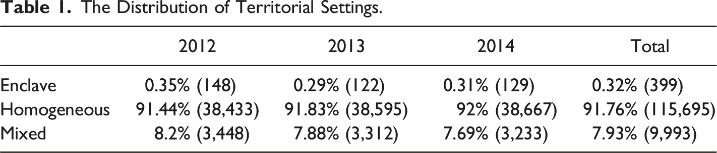
These divergent empirical observations suggest that the impact of natural disasters varies across territories. This raises the question: Why do natural disasters escalate conflict dynamics in some territories, while in others they do not? This paper addresses this question by considering an understudied factor: the spatial configuration of territorial control in the location struck by a disaster. I introduce a typology of the spatial configuration of territorial control, which considers the control of both the given territory and its neighboring territories. I argue that the impact of natural disasters differs across three pre-disaster spatial configurations of territorial control: (1) the homogeneous setting, where the affected territory is encompassed by the territories controlled by the same actor; (2) the enclave setting, where the affected territory is encircled by the territories controlled by the rival; (3) the mixed setting, where the affected territory is surrounded by multiple territories, some of which are controlled by the same actor, others controlled by the rival.
I present a theoretical framework in which natural disasters are treated as exogenous shocks that disrupt the local power balance. Natural disasters create opportunities for belligerents to exploit the temporary weaknesses of affected opponents to expand territorial control. However, the extent of this opportunity is conditional upon the pre-disaster spatial configuration of territorial control. More specifically, I suggest that in a homogeneous setting, logistical constraints prevent the rival from exploiting the disaster-induced weakness. In an enclave setting, the weakened force is highly vulnerable, leading to shifts in territorial control with minimal battle-related violence. In a mixed setting, the defender may either reinforce the territory, resulting in increased battle-related violence without shifts in territorial control, or abandon it, producing conflict dynamics similar to those in an enclave setting. Additionally, since governments tend to have superior logistical capacity, they can reinforce affected territories more effectively than rebels. Consequently, natural disasters have a more pronounced effect on rebel-controlled territories.
Empirically, I employ a difference-in-differences design (DID) to explore the role of the pre-disaster spatial configuration of territorial control in moderating the relationship between natural disasters and two conflict outcomes - shifts in territorial control and battle-related violence. To study shifts in territorial control, I use fine-grained spatial data on natural disasters and territorial control at the barangay-year level in the Philippines (excluding the Autonomous Region in Muslim Mindanao (ARMM)1) between 2012 and 2014. The Philippines, which experienced frequent rainfall-related natural disasters such as storms or floods, and has an ongoing civil war between the NPA and the government, provides an ideal testing ground. For the analysis of battle-related violence, I use barangay-month level data from the Davao region between 2012 and 2014. Located in southeastern Mindanao, the Davao region was a hotbed for the NPA activity during the study period.
Supporting the theoretical expectation, I find that the impact of natural disasters on shifts in territorial control and battle-related violence varies depending on the pre-disaster spatial configuration of territorial control. The empirical findings suggest that, after natural disasters, shifts in territorial control increase in mixed and enclave settings, but not in the homogeneous setting. Battle-related violence increases in the mixed setting only. Additionally, the impact of natural disasters on shifts in territorial control in mixed and enclave settings is more pronounced in rebel-controlled territories.
This paper offers several contributions. First, I introduce a new moderator that explains variation in the relationship between natural disasters and conflict dynamics. Existing literature that emphasizes the importance of disaster location focuses on whether natural disasters hit conflict zones (Rosvold 2019), or on which combatant is victimized (Nemeth and Lai 2022). Instead, I introduce a typology of spatial configurations of territorial control and analyze the heterogeneous effects of natural disasters across these pre-disaster spatial configurations. Second, I analyze how natural disasters differently affect both shifts in territorial control and battle-related violence. This extension is important because territorial control is a key strategic objective during civil wars. By focusing on the occurrence of battle-related violence alone, existing literature overlooks shifts in territorial control that may occur without explicit acts of violence, such as strategic withdrawals. Third, I address limitations in existing empirical research on natural disasters by introducing a new measure of rainfall-related natural disasters. Commonly used datasets, such as the Emergency Event Database (EM-DAT), suffer from the incomplete subnational coverage and endogeneity concerns due to the definition of natural disasters based on their human implications. To mitigate these issues, I construct a new measure using precipitation data from NASA’s Integrated Multi-satellite Retrievals for GPM (IMERG).
Literature Review
Existing literature presents various theoretical mechanisms and empirical predictions on how natural disasters affect conflict dynamics. Some suggest an adverse effect of natural disasters on conflict dynamics, arguing that such disasters exacerbate violent conflicts (Kikuta 2019; Nel and Righarts 2008), fuel terrorist attacks (Adam and Tsavou 2022; Berrebi and Ostwald 2011), prolong conflict duration (Eastin 2016), or escalate repression (Wood and Wright 2016).
The literature identifies two primary theoretical mechanisms that underlie empirical findings. First, natural disasters may exacerbate grievances. The environmental security literature suggests that natural disasters contribute to escalating “simple scarcity conflicts” (Homer-Dixon 1999). Additionally, natural disasters are argued to have psychological implications (Kelman 2012; Slettebak 2012). Scholars posit that disasters can increase individuals’ discomfort and aggression, potentially leading to increased violence or triggering other forms of unrest, including protest (Anderson and Bushman 2003; Flores and Smith 2013).
Second, natural disasters may widen opportunities for conflict. Eastin (2016) indicates that natural disasters damage infrastructure and strain state finances, thereby weakening the government’s capacity to combat rebel groups. This creates a window of opportunity for rebels to escalate conflict intensity (Berrebi and Ostwald 2011), or prolong conflict duration (Nardulli et al., 2015). Others focus on the impact on rebels, arguing that these disasters disrupt their supply lines and paralyze their mobilization capacity. Consequently, this may shift conflict dynamics in favor of the government, potentially resulting in a reduction in conflict intensity or enabling increased government territorial reclamation (Kreutz 2012; Tominaga and Lee 2021; Walch 2018).
In contrast, an alternative line of research emphasizes the potential pacifying effect of natural disasters. Scholars in the sociology of natural disasters propose the formation of a “community of sufferers” built upon inter-subjective understanding, which helps mitigate preexisting divides and deter violence (Fritz 1996; Kang and Skidmore 2018; Slettebak 2012). Likewise, the disaster diplomacy literature argues that humanitarian activities and international involvement, together with domestic emergency responses in disaster-stricken regions, can contribute to short-term peace-building efforts (Kelman 2012).
The divergent findings underscore the significance of moderators, with an emerging consensus suggesting that the impact of natural disasters on conflict dynamics varies across contexts (Xu et al. 2016; von Uexkull and Buhaug 2021). Various moderators have been explored in existing literature, including ethnic heterogeneity (Schleussner et al. 2016), local institutions (Linke et al. 2018; Petrova 2021), state capacity (Adam and Tsavou 2022), post-disaster aid (Juan et al., 2020), or rebel–civilian relationships (Walch 2014).
Following the emphasis on moderators, some scholars suggest the significance of disaster location in understanding how natural disasters affect conflict dynamics. Instead of solely evaluating whether a natural disaster occurs, it is important to disaggregate its effects based on where the disaster occurs. Existing research explores disaster location as a moderator by investigating whether natural disasters occur within conflict zones (Rosvold 2019) or which combatant is victimized (Nemeth and Lai 2022). Despite their contributions, these studies focus on a single dimension - either the geographical location of the disaster or the identity of the affected actor. By focusing on the pre-disaster spatial configuration of territorial control, which considers the territorial control of both the given territory and its neighboring territories, this paper not only considers where disasters occur and who is impacted, but also the strategic interactions among belligerents.
Additionally, as reviewed above, the existing literature has examined various conflict outcomes. However, territorial control, which serves as a key goal for both belligerents in a civil war (Kalyvas 2006; O’Sullivan 1983) remains understudied in empirical research. Shifts in territorial control can still occur without explicit acts of violence. This is particularly evident when the defending force is incapacitated due to natural disasters. Thus, it is necessary to examine battle-related violence as a means and shifts in territorial control as an outcome.
Finally, the existing literature is notably restricted by the measure of natural disasters. Previous research often relies on event-level datasets such as EM-DAT. However, this approach faces criticism (Rosvold and Buhaug 2021; Tin et al. 2024). First, these datasets often lack a complete subnational coverage of natural disasters, limiting the feasibility of within-country research designs. For example, EM-DAT includes many cases where location names cannot be matched to a specific geographical area or refer to multiple locations within the same country (Rosvold and Buhaug 2021). Second, the EM-DAT definition of natural disasters relies on human and social vulnerability, which introduces endogeneity concerns, as socioeconomic attributes such as poverty or ineffective governance may contribute to both vulnerability to natural disasters and conflict dynamics (Felbermayr and Gröschl 2014; Osberghaus 2019). To address these limitations, I employ a new measure of natural disasters based on precipitation data from IMERG.
Theory
This paper focuses on the type of civil war in which rebels cannot move military resources freely, while governments retain greater mobility and logistical advantages. Also, it examines conflicts between two direct rivals, though the theory has the potential to extend to civil wars involving multiple armed actors. The case of the Philippines meets these scope conditions, as it centers on the direct contest between the Philippine government and the NPA. 2
Both territorial control and contention are important concepts in the study of civil wars. Territorial control serves as a key goal for belligerents involved in civil wars (O’Sullivan 1983). Governments seek to maintain control over territory within their boundaries. Rebels often pursue the opposite - working toward goals such as overthrowing the government or achieving secession (Hammond 2018). Contention, often manifested through battle-related violence, serves as a strategic means to contest or defend territorial control (Kalyvas 2006).
While shifts in territorial control and contention are interrelated, they are distinct phenomena. Shifts in territorial control may occur without battle-related violence, especially in the aftermath of exogenous shocks such as natural disasters. In such scenarios, the defending force may become incapacitated due to the impact of natural disasters and subsequently choose to retreat or surrender, thus relinquishing the territory. Conversely, battle-related violence can occur without any shift in territorial control. For instance, failed offensives, where an attacking force is unable to break through strengthened defensive lines, often result in intense fighting and high casualties without altering territorial control (Kalyvas 2006). I examine both shifts in territorial control and contention in tandem, which provides a more comprehensive understanding of how these two conflict outcomes evolve during civil wars.
Scholars and practitioners have long argued that the distribution of military power is pivotal in determining territorial control, with the belligerent holding a relative power advantage often winning a given territory (Kovenock and Roberson 2012; Roberson 2006). This power advantage broadly depends on military resources, including civilian collaboration, infrastructure, and military personnel and equipment.
First, civilian collaboration is important because it influences both counterinsurgency tactics and rebel violence (Kalyvas 2006; Sonin and Wright 2023). In counterinsurgency operations, information on rebel activities is considered ‘a central resource within civil wars’ (Lyall et al., 2013), and rebels similarly rely heavily on civilian collaboration (Sonin and Wright 2023). Second, infrastructure, such as roads, bridges, and communication networks, plays a pivotal role by enhancing the military efficacy of counterinsurgency (Eastin 2016). This argument also extends to rebels, since such infrastructure serves as key supply lines that influence their combat capabilities (Hammond 2018; Walch 2018). Third, personnel and equipment are indispensable for both belligerents and can be deployed across multiple territories, thus shaping local power dynamics (Eastin 2016).
An exogenous shock that disrupts the prior power balance is the occurrence of natural disasters. Natural disasters can significantly alter civilian support, destroy infrastructure, and impact military resources. First, natural disasters threaten civilian survival and influence their collaboration decisions. Civilians may inform the rival when the opportunity cost of collaboration with the rival falls and grievances against the de facto controller rise (Hendrix 2013; Walch 2018). Second, natural disasters may damage infrastructure, personnel, and equipment in the affected territory, thereby weakening the military capacity of the de facto controller, including either government forces or rebels (Eastin 2016; Tominaga and Lee 2021).
Thus, natural disasters disrupt the balance of power between belligerents. This disruption creates opportunities for both shifts in territorial control and battle-related violence, depending not only on the extent to which one belligerent is weakened, but also on the pre-disaster spatial configuration of territorial control. Belligerents strategically choose their optimal targets based on the costs of attack and the rival’s capacity to reallocate their personnel and equipment for defense. These strategic considerations are shaped by the pre-disaster spatial configuration of territorial control.
I propose a typology of pre-disaster spatial configurations of territorial control. This typology accounts for the territorial control of both the given territory and its neighboring territories. It includes three empirically exhaustive categories: the homogeneous setting, where the affected territory is encompassed by the territories controlled by the same actor, the enclave setting, where the affected territory is encircled by the territories controlled by the rival, and the mixed setting, where the affected territory is surrounded by multiple other territories, some of which are controlled by the same actor, others controlled by the rival, as shown in Figure 1. Territorial settings. A. Homogeneous, B. Enclave, C. Mixed. Note. Squares and triangles represent territories controlled by two opposing belligerents. Red shapes indicate the central territory in each setting.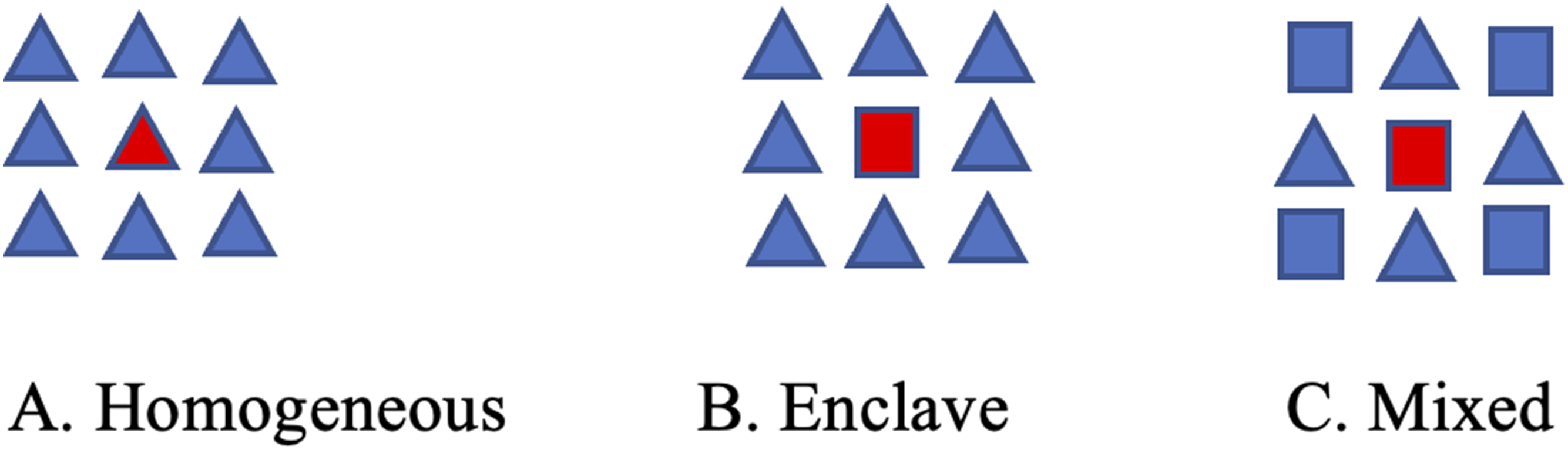
I consider both contiguous and non-contiguous movements. Under contiguous movement, both belligerents allocate military personnel or equipment to the affected territory only from neighboring territories, as reallocation from non-adjacent territories is prohibitively costly. Contiguous movement provides a simplified baseline for understanding how spatial configurations influence post-diaster shifts in territorial control and battle-related violence. I also extend the analysis to non-contiguous movement, in which one belligerent – often the government – possesses superior logistical capacity such as the use of air transport to reinforce its defense (Walch 2018). While this capacity introduces additional strategic options, reliance on adjacent territories remains critical in determining how territorial control is contested. 3
Under contiguous movement, I theorize that the impact of natural disasters on shifts in territorial control and battle-related violence varies across different spatial configurations of territorial control, as they affect post-disaster military strategies, including the cost of moving military personnel and equipment for offensive operations, and the rival’s capacity to reallocate forces to reinforce defense.
In the homogeneous setting, natural disasters weaken the military capacity of the controller in the affected territory. However, because the affected territory within this setting is surrounded by its own controlled territories, the configuration, combined with limited logistical capacity on both sides, makes a successful attack on the affected territories highly unlikely. Belligerents can only move personnel or equipment into directly adjacent territories, which makes it prohibitively costly for the rival to initiate an attack across multiple territories. Thus, I expect that:
In the enclave setting, natural disasters also weaken the actor controlling the affected territory, making it more vulnerable to become a target. At the same time, the unique spatial configuration of the enclave setting enables the rival to exploit the post-disaster power imbalance and seize control of the affected territory. The rival can reallocate military personnel and equipment from its adjacent controlled territories to launch an attack, while the affected actor cannot move forces across adjacent rival-controlled territories to reinforce the affected territory. In this power-imbalanced context, the defending force is at a severe disadvantage and is often overwhelmed or forced to retreat. Thus, I expect that
In the mixed setting, natural disasters weaken the controller in the affected territory. However, its unique spatial configuration introduces more complex strategic considerations for the affected actor. The mixed setting is characterized by the affected territory being encircled by territories, some of which are controlled by the affected actor, and others controlled by the rival. The affected actor faces a strategic decision: whether to defend the affected territory or abandon it. They may choose to reinforce the territory by reallocating military personnel or equipment from adjacent controlled territories, or opt for a strategic withdrawal. The decision depends on whether the value of the affected territory outweighs the costs of defending it, including the risk of losing the territories from which the defending forces are drawn. If the former outweighs the latter, the affected actor is more likely to defend the affected territory from being taken control by the rival. As a result, battle-related violence is more likely, as the rival attempts to exploit temporary weakness by attacking it, while the territory’s strategic value draws in more defending forces. If the latter outweighs the former, the affected actor is more likely to abandon the territory, resulting in a scenario that mirrors the enclave setting. Thus, I expect that
The impact of natural disasters on shifts in territorial control may spillover into adjacent unaffected territories, as the affected actor reallocates military personnel and equipment from those adjacent territories to defend the disaster-affected territory. In civil wars, belligerents often target the most vulnerable territories, including those affected by natural disasters. However, when the affected territory is considered highly valuable, the affected belligerent may choose to reallocate military personnel and equipment from adjacent territories to defend it (Eastin 2016; Powell 2007). This reallocation disrupts the power balance in the territories from which military personnel and equipment are moved out, rendering them more vulnerable. As a result, the affected actor is more likely to strategically abandon those less valuable territories without engaging in battle-related violence. Thus, I expect that
Additionally, I examine an extended form of non-contiguous movement, in which the government can move personal and equipment from non-adjacent territories (reflecting e.g. air transport capacity), while rebels can only mobilize personnel and military equipment from adjacent territories. Following natural disasters, rebels face logistical challenges in reinforcing their defense due to limited access to infrastructure and equipment, whereas governments can allocate resources nationwide (Walch 2018). Consequently, the impact of natural disasters is more pronounced in rebel-controlled territories and varies depending on the pre-disaster spatial configuration of territorial control. In the homogeneous setting, given the high cost of cross-territory attacks, I expect that the lack of the impact from natural disasters on two conflict outcomes remains unchanged.
In contrast, in the enclave setting, the government can reinforce affected territories by reallocating military personnel and equipment from more distant territories, leveraging its superior logistical capacity. A similar military reallocation can also be observed in the mixed setting. As a result, rebels face greater difficulty in seizing control of the affected territory due to the potential for defense reinforcements. As defending forces are reinforced in government-controlled territories, the likelihood of battle-related violence may increase, as rebels encounter stronger resistance during attempted attacks. Thus, I expect that
Research Design
I empirically test my hypotheses using a DID design to analyze the impact of natural disasters on two conflict outcomes. For shifts in territorial control, I study the civil war between the NPA and the Philippine government between 2012 and 2014 at the barangay-year level. For battle-related violence, I focus on the Davao region only between 2012 and 2014 at the barangay-month level. 4 The barangay is selected as the unit to conceptualize the territory because it represents the smallest administrative and governance unit in the Philippines, making it an ideal level for examining localized conflict dynamics. As the primary site of state governance and community interaction, the barangay is also a focal point of the NPA activity (Richard 1989). This alignment is further reflected in counterinsurgency guidelines, which prioritize interventions and data collection at the barangay level. 5
The Philippines serves as an optimal testing ground due to its frequent exposure to rainfall-related disasters and the ongoing communist insurgency. Nemeth and Lai (2022) examine how the victimization of combatants by natural disasters influences negotiation outcomes, citing the Philippines as a key illustrative case. Additionally, qualitative research by Walch (2014) shows that government forces intensified the military operations in the NPA-controlled territories following the Typhoon Bopha in 2012, which hit territories under the NPA control. This empirical evidence aligns with my theoretical expectation.
Conflict Outcomes
I focus on two outcomes: shifts in territorial control and the occurrence of battle-related violence. Two datasets are constructed. For shifts in territorial control, the dataset encompasses 42,029 barangays across 1647 municipalities in the Philippines (excluding the ARMM). For battle-related violence, due to data availability, the dataset is confined to the Davao region, where the NPA was most active during the specified 3-year period. It comprises 1161 barangays across 49 municipalities.
I measure shifts in territorial control using the Armed Forces of the Philippines (AFP) intelligence assessments. These assessments, while primarily intended for internal use, serve as a valuable tool for avoiding the implementation of peace-building or economic development initiatives in areas with security concerns. These year-end reports categorize each barangay into a four-category scale of NPA presence, defined as: 0) Unaffected, (1) Threatened, (2) Less Influenced, and (3) Influenced. Notably, the 2012 assessment does not distinguish between “less influenced” and “influenced” or between “threatened” and “unaffected” designations. Thus, I collapse the scale into a binary variable: 1 indicates the NPA presence (“less influenced” or “influenced” barangays) and zero denotes government control (“threatened” and “unaffected”).
6
This measure captures institutions of rebel control. Unlike short-term territorial fluctuations, these rebel-controlled territories reflect a more stable organizational structure capable of sustaining military operations. The shift in territorial control is calculated as the difference between the given year and the preceding year.
7
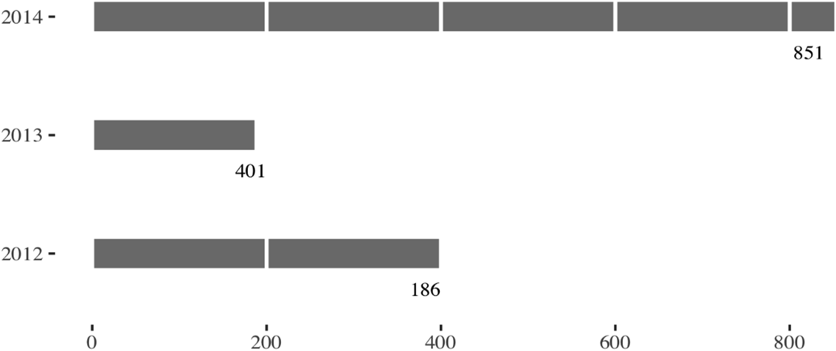
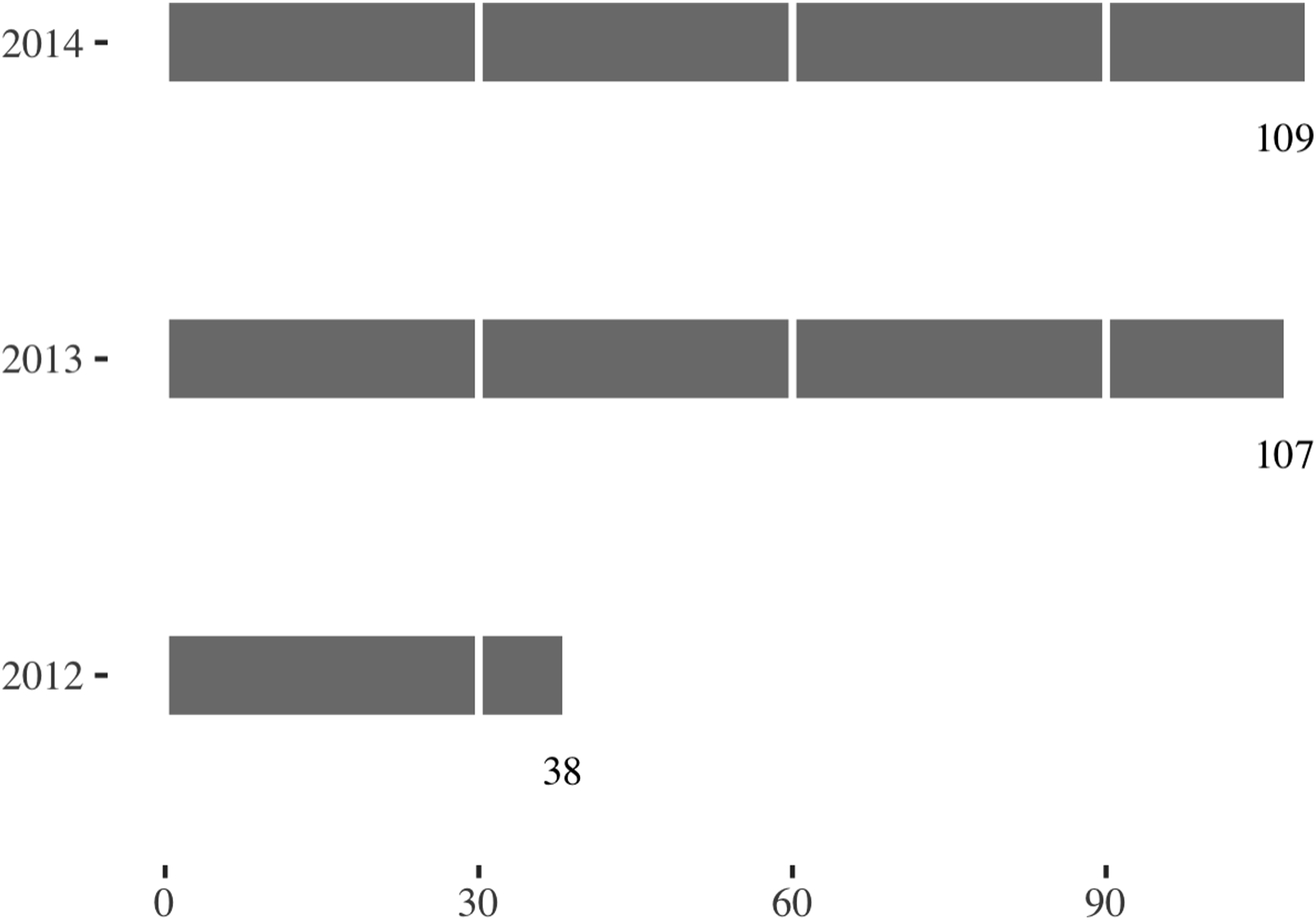
It takes a value of 1 if there is a shift in territorial control (from rebel to government or vice versa) and zero otherwise. Figure 2 illustrates that 1438 barangays (3.4%) experienced a shift in territorial control at least once between 2012 and 2014. Figure 3 shows the annual number of shifts in territorial control over the study period. The number of barangays that underwent shifts in territorial control decreased from 401 in 2012 to 186 in 2013, but then increased to 851 in 2014. The spatial distribution of shifts in territorial control. Note. The map illustrates the barangays that experienced at least one shift in territorial control between 2012 and 2014. The number of barangays with a shift in territorial control by year, between 2012 and 2014.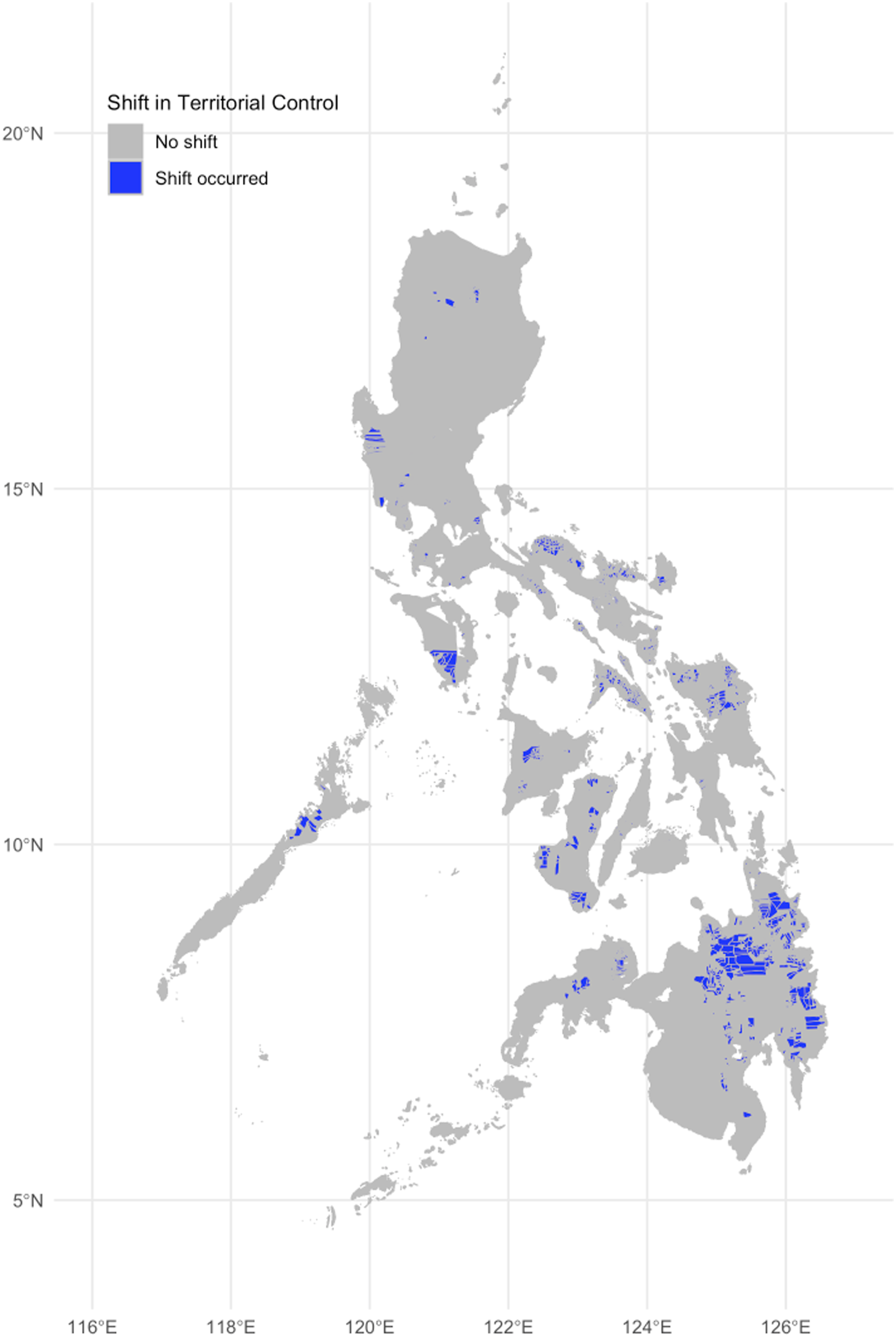
The second outcome is battle-related violence. I measure it using data from the Bangsamoro Conflict Monitoring System (BCMS).
8
The BCMS collects information from “regional and provincial police blotters”, supplements it with “media reports”, and subsequently validates the data through “meetings with various local stakeholders”. This three-stage process enhances the reliability and granularity of the dataset. However, BCMS data exclusively covers the ARMM and the Davao region. Furthermore, the dataset includes various forms of violence, including clashes among civilians or clans, as well as those involving rebel groups and the government. For the analysis, I focus on the Davao region and the conflict between the NPA and the government. I aggregate the data at the barangay-month level and create a binary variable indicating whether battle-related violence occurred within 1 year following a given month. This variable is coded as 1 if any battle-related violence occurred in the barangay during the 12-month period after that month, and zero otherwise. Since battles often require preparation time, the 1-year window is used to capture the delayed impact of natural disasters on battle-related violence. As a robustness check, I also use a count variable at the barangay-month level, which measures the number of incidents of battle-related violence per barangay each month. Figure 4 shows the spatial distribution of battle-related violence in the Davao region, where 10.4% of barangays experienced battle-related violence at least once between 2012 and 2014. Figure 5 presents the annual trend in battle-related violence. The spatial distribution of battle-related violence. Note. The map illustrates the barangays that experienced at least one conflict incidence between 2012 and 2014. The number of barangays that experienced battle-related violence by year, between 2012 and 2014.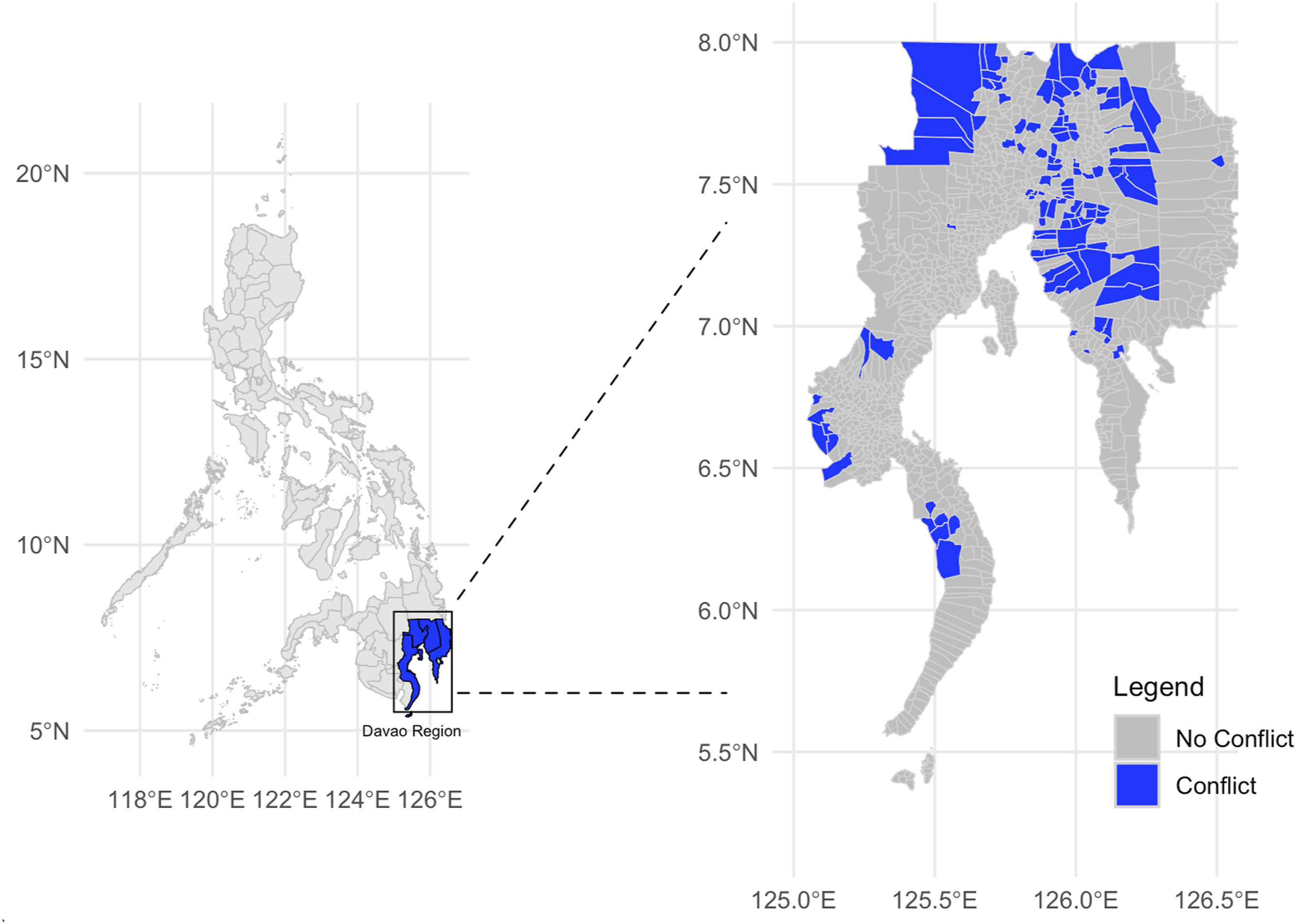
Natural Disasters as the Treatment
The main explanatory variable is the occurrence of natural disasters. 9 Given that the predominant natural disasters in the Philippines are extreme rainfall events, including landslides, floods, and storms, I classify a unit as having experienced a natural disaster when the precipitation deviation exceeds a barangay-specific threshold derived from the event-level dataset of EM-DAT. 10 Given the short study period (2012–2014) and the fact that disaster recovery often spans multiple years, a staggered adoption design is applied as the main specification for a better causal estimation. To avoid bias caused by lingering effects of previous disasters, I treat the period between the first and second hits of natural disasters in each barangay as a distinct treatment phase, and exclude the periods after the second hit as well as affected barangays in 2010 and 2011 (Hassell and Holbein 2024; Xu et al. 2016). 11 As an alternative, I define the natural disaster occurrence at the barangay-month level by assigning a value of 1 if a barangay’s precipitation deviation exceeds the threshold in a given month, and zero otherwise.
This measure mitigates two concerns about EM-DAT raised above. First, the geographical precision of the precipitation data addresses EM-DAT’s incomplete subnational coverage of natural disasters. Second, including precipitation - an exogenous phenomenon - mitigates the endogeneity concern in EM-DAT’s disaster definition.
Precipitation deviation is based on the Integrated Multi-satellite Retrievals for GPM (IMERG) dataset, version 6.0, which provides monthly precipitation estimates aggregated at the barangay-month level. 12 The dataset offers a 0.1 ° × 0.1 ° grid resolution (roughly 10 × 10 km) and spans from 2000 to the present, effectively covering the study period.
The precipitation deviation is calculated as the standardized difference between the monthly average precipitation and its 10-year moving average for each barangay-month. The formula is as follows:
To define a threshold for excessive precipitation indicative of a natural disaster, I calculate the precipitation deviation for barangays affected by rainfall-related natural disasters including storms, floods, and landslides. The classification of barangays as experiencing such disasters is based on geographical information from EM-DAT. I use a precipitation deviation value of 1.6 as the threshold for classifying a barangay as experiencing a rainfall-related natural disaster. This corresponds to the third quartile of the precipitation deviation distribution.
In Figure 6, I display the spatial distribution of natural disasters based on my measure. Additionally, Table A16 in Online Appendix K presents a comparison of the annual number of barangays affected by natural disasters (at least once) between my measure and the EM-DAT-based measure. The spatial distribution of natural disasters. Note. The map illustrates the barangays that experienced at least one natural disaster between 2012 and 2014.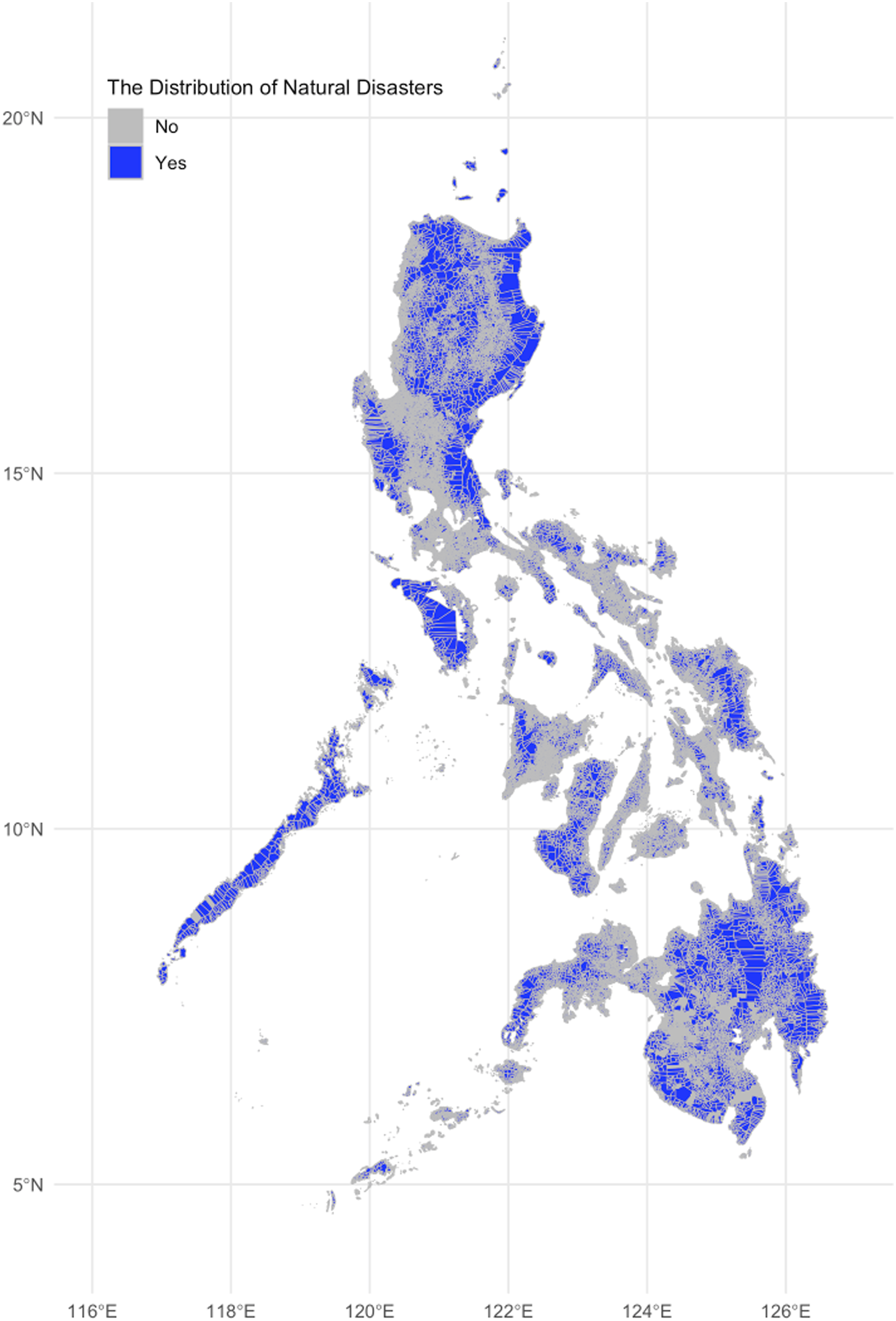
Territorial Setting
The Distribution of Territorial Settings.
Difference-In-Differences Design
To identify how territorial settings moderate the impact of natural disasters on two conflict outcomes, I exploit both the variation between disaster-affected and unaffected territories across different territorial settings, and within-unit changes in the risk of those conflict outcomes for affected territories before and after natural disasters.
I use a two-way fixed effects (TWFE) model to estimate the moderating relationship between natural disasters and conflict outcomes, accounting for common time shocks and time-invariant barangay characteristics. The main specification uses a TWFE model with a staggered adoption design, supplemented by a simple TWFE model that treats natural disasters as an occurrence at a specific time for each barangay. I first estimate the unconditional impact of a natural disaster on two conflict outcomes.
To test the hypotheses concerning the moderator of territorial settings, I include interaction terms between natural disasters and the territorial settings, as specified below.
For the TWFE model to be interpreted causally, it is important that, in the absence of natural disasters, each barangay would exhibit similar conflict dynamics - a parallel trends assumption (PTA). I conduct an event study model to examine the plausibility of parallel trends. This involves using binary treatment indicators for the occurrence of natural disasters, with leads and lags, to assess whether trends in conflict outcomes were comparable prior to the occurrence of disasters (Chiu et al. 2023; Hassell and Holbein 2024). Results from Figure A1 and Figure A2 in Online Appendix D suggest no clear violation of the PTA. 13
Results
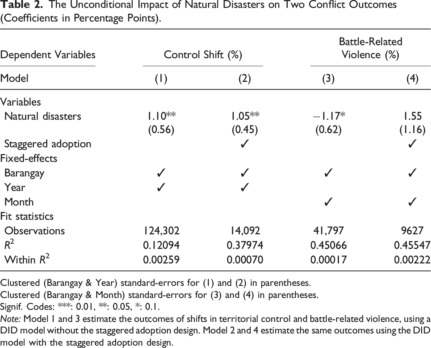
The Unconditional Impact of Natural Disasters on Two Conflict Outcomes (Coefficients in Percentage Points).
Clustered (Barangay & Year) standard-errors for (1) and (2) in parentheses.
Clustered (Barangay & Month) standard-errors for (3) and (4) in parentheses.
Signif. Codes: ***: 0.01, **: 0.05, *: 0.1.
Note: Model 1 and 3 estimate the outcomes of shifts in territorial control and battle-related violence, using a DID model without the staggered adoption design. Model 2 and 4 estimate the same outcomes using the DID model with the staggered adoption design.
Table 2 also presents the results for the occurrence of battle-related violence. Model 4, which uses the staggered adoption design, indicates that the occurrence of natural disasters does not have a statistically significant effect on battle-related violence. This finding aligns with the expectation that shifts in territorial control should be treated independently and not every shift is accompanied by increased battle-related violence. However, it is worth noting that Model 3, which does not use the staggered adoption design, shows a negative and statistically significant effect on battle-related violence at the 10% level.
Main Model
Then, I evaluate the moderating role of territorial settings on the relationship between natural disasters and both shifts in territorial control and battle-related violence. Figure 7 (based on Model 2 with the staggered adoption design in Table A1 in Online Appendix A) presents the results on the moderating effect of natural disasters on shifts in territorial control. As shown in Figure 7, the effect of natural disasters on shifts in territorial control in the enclave setting is positive and statistically significant at the 5% level. This finding supports Hypothesis 2.1, which posits that in enclave settings, natural disasters are more likely to lead to shifts in territorial control. The risk of a shift in territorial control increases by 18.91% in disaster-affected territories within the enclave setting, compared to a 0.39% decrease in affected territories within the homogeneous setting. This result is consistent with Model 1 in Table A1, which does not use the staggered adoption design. A similar pattern is also observed in the mixed setting, where natural disasters also increase the risk of a shift in territorial control. According to Figure 7, the effect of natural disasters in the mixed setting is positive and statistically significant at the 5% level, supporting Hypothesis 3.1, which proposes that natural disasters are more likely to lead to shifts in territorial control in the mixed setting. In affected territories within the mixed setting, the risk of a shift in territorial control increases by 3.90%. Although the estimated coefficients for the enclave and mixed settings are not statistically significantly different, this increase in the risk of a shift in territorial control is substantively larger in affected territories within the enclave setting than in the mixed setting. This supports Hypothesis 3.1, which compares the impact of natural disasters across these two settings. However, the result for the interaction term with the enclave setting should be interpreted with caution, as the statistically significant and positive effect does not hold in Model 1, which does not use the staggered adoption design, as shown in Table A1. The conditional impact of natural disasters on two conflict outcomes, by territorial settings: 90% and 95% confidence intervals. Note. The top panel shows the effect of natural disasters in enclave, mixed, and homogeneous settings on shifts in territorial control (based on Model 2 in Table A1). The bottom panel shows the effect of natural disasters in the same settings on battle-related violence (based on Model 2 in Table A2).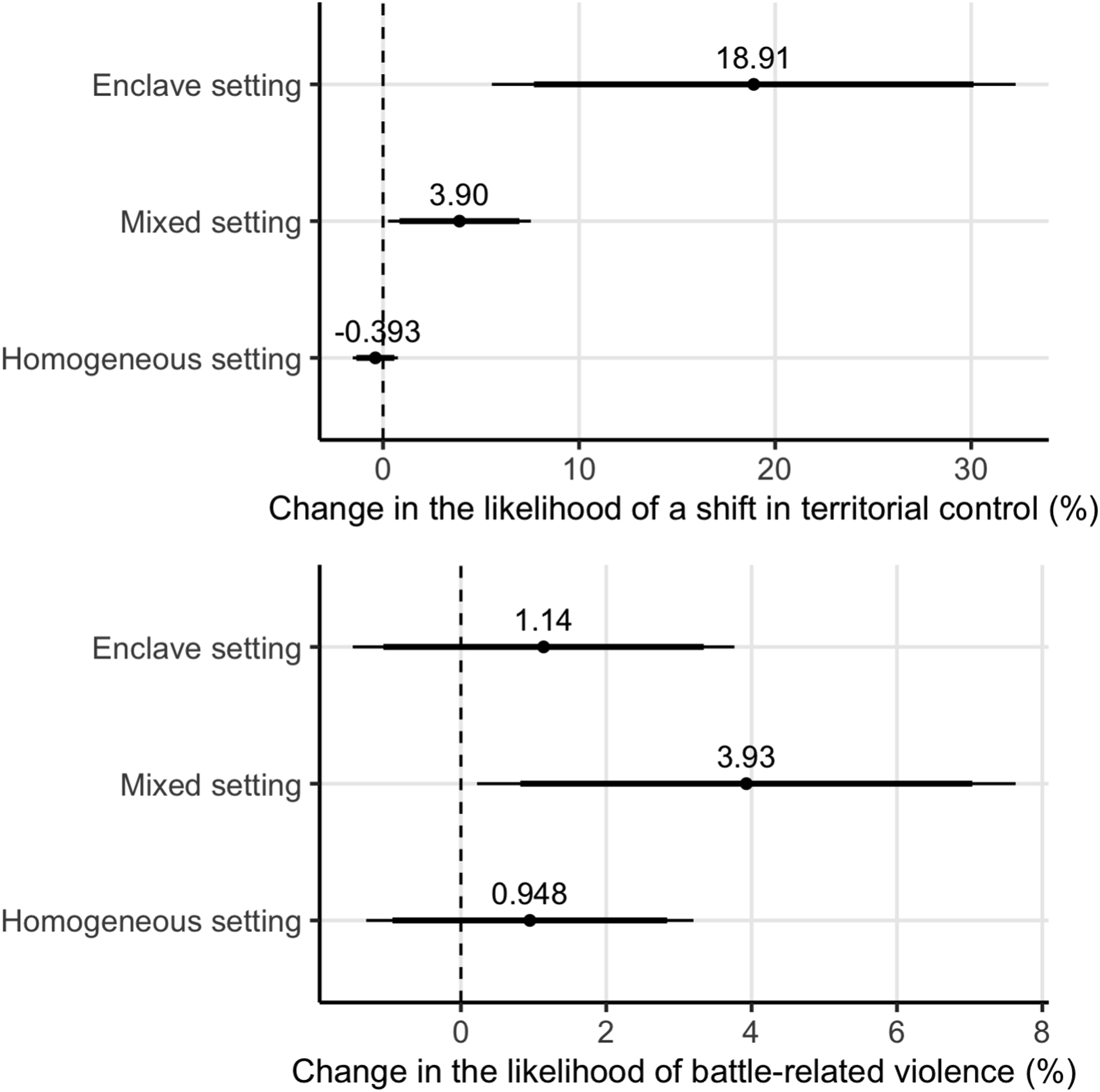
Figure 7 (based on Model 2 in Table A2) also presents results on the moderating effect of natural disasters on battle-related violence. As shown in the bottom panel of Figure 7, the effect of natural disasters in the mixed setting is positive and statistically significant at the 5% level. This finding suggests that battle-related violence is more likely to occur in disaster-affected territories within the mixed setting. The risk of battled-related violence increases by 3.93% in affected territories within the mixed setting, compared to a 0.95% increase in the homogeneous setting. This supports Hypothesis 3.2, which posits that in the mixed setting, natural disasters are more likely to lead to increased battle-related violence. However, it is worth noting that the positive and statistically significant result does not hold in Model 1, which does not use the staggered adoption design, as shown in Table A2.
Consistent with Hypotheses 1.2 and 2.2, the results show no statistically significant effect of natural disasters on battle-related violence in either homogeneous or enclave settings.
The Spillover Effect of Natural Disasters
Additionally, I examine the spillover effect of natural disasters. According to Model 2 in Table A5 (Online Appendix C), the interaction term between the spatial lag of the occurrence of natural disasters and the spatial lag of the mixed setting is positive but not statistically significant. This finding does not support Hypothesis 4.1, which posits an increased risk of a shift in territorial control in adjacent unaffected territories within the mixed setting. Similarly, Model 2 in Table A6 shows that the interaction term with the spatial lag of the mixed setting is negative and not statistically significant, providing no support for Hypothesis 4.2, which concerns the occurrence of battle-related violence in adjacent unaffected territories.
Non-Contiguous Movement
I further examine shifts in territorial control and battle-related violence under non-contiguous movement. To assess how the moderating effect of rebel control varies across different spatial configurations, I include three-way interaction terms between natural disasters, mixed or enclave settings, and rebel control. Figure 8 (based on Model 2 in Table A3 and Model 2 in Table A4) presents these results for both shifts in territorial control (top panel) and battle-related violence (bottom panel). The conditional effect of natural disasters on two conflict outcomes: a three-way interaction between natural disasters, territorial setting, and rebel Control. Note. The top panel shows results for shifts in territorial control (based on Model 2 in Table A3), and the bottom panel presents results for battle-related violence (based on Model 2 in Table A4. In both panels, from the top to bottom, the results show the effect of natural disasters in: (1) government-controlled territories within the enclave setting, (2) rebel-controlled territories within the enclave setting, (3) government-controlled territories within the mixed setting, (4) rebel-controlled territories within the mixed setting, (5) government-controlled territories within the homogeneous setting, (6) rebel-controlled territories within the homogeneous setting.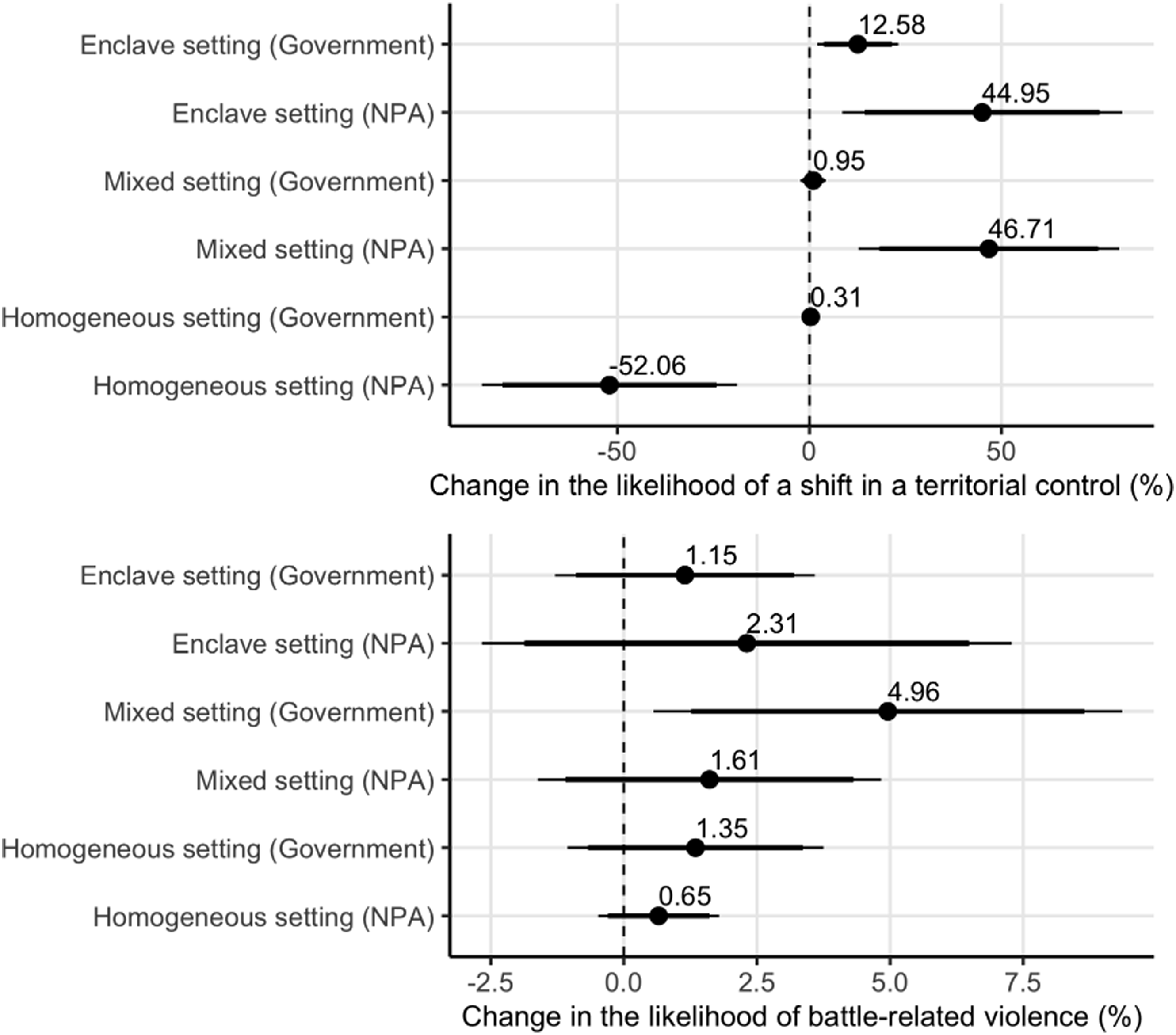
As shown in the top panel of Figure 8, the effect of natural disasters on the risk of a shift in territorial control is more pronounced in rebel-controlled territories within the mixed and enclave settings compared to government-controlled ones. Specifically, in rebel-controlled territories affected by a disaster, the risk of a shift in territorial control increases by 46.71% in the mixed setting and by 44.9% in the enclave setting. In contrast, the corresponding increases in government-controlled territories are only 0.95% and 12.58%, respectively. These findings support Hypothesis 5.1, which posits a stronger effect of natural disasters on shifts in territorial control in rebel-controlled territories within enclave or mixed settings.
However, for battle-related violence, the bottom panel of Figure 8 shows a positive and statistically significant effect of natural disasters in government-controlled territories within the mixed setting, but not in the enclave setting. This provides only limited support for Hypothesis 5.2.
Robustness
The results remain robust across various robustness checks, including adjustments for the choice of the barangay as to conceptualize the territory, concerns about spatial dependence, and alternative measurements of key variables such as natural disasters, territorial settings, and conflict outcomes.
First, a critical consideration in this study is how territory is conceptualized across different levels of spatial aggregation. While the barangay, the smallest administrative unit in the Philippines, serves as the most granular level for governance and conflict engagement, it raises questions about whether this level adequately captures broader territorial dynamics. For example, a homogeneous setting at the barangay level may appear as an enclave setting when analyzed at a higher level of aggregation. To address this concern, I conduct additional tests at the municipality level. I recalculate the municipality-level precipitation deviations and reclassify territorial control based on aggregated barangay data. The results from Online Appendix F confirm that the localized conflict patterns observed at the barangay level largely hold at the municipality level, particularly in the enclave setting.
Differences in the geographic size of barangays may also influence how territorial settings are classified, potentially shaping conflict dynamics. Larger barangays require a greater number of surrounding enemy-controlled territories to be classified as enclave or mixed settings. In contrast, smaller barangays are more easily classified as enclave or mixed settings, as fewer surrounding enemy-controlled areas are required to meet the classification threshold. To address this concern, I examine the distribution of barangay sizes and find that 90% fall within a range, from −0.389 to 0.422 z-scores relative to the mean size of 7 km2 (see Table A10 in Online Appendix G). Furthermore, to account for the influence of outliers, I re-estimate the models using restricted samples that exclude the most extreme 5% and 10% of barangays by size. The results for shifts in territorial control remain robust (see Tables A11 and Table A12 in Online Appendix G).
Additionally, recognizing that regions without the NPA presence may differ systematically from contested territories, I restrict the analysis to municipalities and provinces where the NPA is present. However, this sample restriction cannot be applied to the analysis of battle-related violence, as the Davao region is a hotspot for the NPA activity, with the NPA presence in most municipalities. The results for shifts in territorial control remain robust (see Table A13 in Online Appendix H).
Second, another concern in this study is the spatial dependence. Variables such as rainfall-related natural disasters, territorial settings, and the two conflict outcomes may be spatially correlated. To address this, I re-estimate the main models with Conley standard errors (Conley 1999), applying alternative distance cutoffs of 10 km, 20 km, 50 km, 100 km, and 200 km. The results, presented in Table A14 and Table A15 in Online Appendix I, confirm that the findings for shifts in territorial control remain robust. For battle-related violence, the results hold in models using Conley standard errors with cutoffs of 100 km and 200 km.
Additionally, I conduct a randomization inference (see details in Online Appendix J). I randomly reshuffle the values of Di,t across the study period. For example, Di,t in December 2011 may be replaced by its value from December 2012. I repeat this process 1000 times and estimate placebo effects for each iteration. I then compare the actual estimates of the interaction terms between natural disasters and the mixed or enclave settings based on Model 2 in Table A1 for shifts in territorial control and Model 2 in Table A2 for battle-related violence (Online Appendix A) to the distribution of these placebo effects. The estimated interaction effect between natural disasters and the mixed setting exceeds 95% of the placebo estimates (p < 0.05) for both shifts in territorial control and battle-related violence, while the interaction effect for the enclave setting exceeds 90% (p < 0.1) for shifts in territorial control and 95% (p < 0.05) for battle-related violence.
Third, a further concern relates to the measurement of key variables, including natural disasters, territorial settings, and conflict outcomes. To address this issue, I conduct a series of robustness checks using alternative measurements informed by both theoretical and empirical considerations.
Regarding the measurement of natural disasters, while my threshold-based approach - using monthly precipitation deviation - captures average monthly precipitation, it may overlook short-term rainfall intensity. A higher precipitation deviation, when coupled with rainfall concentrated over a short period, constitutes a more severe disaster than the same total precipitation distributed evenly throughout the month. 14 To test this, I incorporate monthly rainfall concentration into the model and asseses its moderating effect on conflict outcomes. Monthly rainfall concentration is calculated using the IMERG dataset (version 6.0), which provides daily precipitation estimates. I use these daily values to calculate the monthly rainfall concentration. According to Model 2 in Table A17 (Online Appendix L), the impact of natural disasters on shifts in territorial control in the mixed setting is more pronounced during months with higher rainfall concentration. However, this effect is not observed in the enclave setting. According to Model 2 in Table A18 (Online Appendix L), the moderating impact of rainfall concentration is not observed for battle-related violence.
I also examine the heterogeneous effects of disaster severity by testing alternative thresholds for defining natural disasters, ranging from 1.5 to 2 precipitation deviation. Figure A7 and Figure A8 in Online Appendix N present results for both conflict outcomes. For shifts in territorial control, the effect of natural disasters in both mixed and enclave settings becomes notably stronger at the thresholds of 1.9 and 2, which suggests that more severe disasters are more likely to lead to shifts in territorial control. For battle-related violence, the impact becomes negative in both mixed and enclave settings, indicating that severe disasters may reduce battle-related violence. One possible explanation is that the greater destruction caused by severe disasters forces defending forces to withdraw and thus enables shifts in territorial control without direct confrontation.
As an alternative to the threshold-based measure of natural disasters, I estimate a zero-stage model to assess the impact of natural disasters on both conflict outcomes. In the first stage, the occurrence of natural disasters based on EM-DAT geographical information is regressed on monthly precipitation deviation and rainfall concentration. In the second stage, the two conflict outcomes are regressed on the predicted values of natural disasters from the first stage (see Online Appendix M for more details). The results for both conflict outcomes remain robust.
For the measurement of territorial settings, while my main theory simplifies the spatial configuration of territorial control into three discrete territorial settings, the actual spatial configurations can be more complex. The proportion of neighboring territories controlled by enemy forces varies across affected territories. To account for this complexity, I further test the impact of pre-disaster spatial configurations of territorial control on shifts in territorial control by incorporating both the extensive and intensive margins of enemy-controlled neighboring territories. The extensive margin captures the presence of any enemy-controlled territory in the vicinity, while the intensive margin measures the proportion of neighboring territories under enemy control, ranging from 10% to 90% in 10% increments. As shown in Figure A9 (Online Appendix Q), the marginal effect of enemy control on shifts in territorial control intensifies as the proportion increases, with the strongest effects observed at 60% and 90%. Beyond 60%, the effect slightly attenuates, suggesting possible saturation effects.
For the measurement of battle-related violence, instead of using a binary indicator, I also examine the total number of battle events per month to capture the intensity of contention. To address potential overdispersion in the outcome variable, I use count models - specifically, Poisson and negative binomial regressions. The results remain robust, as shown in Table A25 (Online Appendix S).
Additionally, I test whether the moderating effect of natural disasters on battle-related violence holds under alternative temporal aggregations of battle-related violence (see Figures A11 and A12 in Online Appendix T). The results remain robust.
Conclusion
This paper presents a theoretical model and subnational quantitative analysis of the relationship between natural disasters and two conflict outcomes: shifts in territorial control and battle-related violence, introducing the spatial configuration of territorial control as a moderator. This paper delineates three distinct territorial settings: homogeneous, enclave, and mixed to capture the pre-disaster spatial configuration. This paper argues that natural disasters disrupt the power balance in affected territories. However, the impact varies across pre-disaster spatial configurations of territorial control, as these offer different opportunities for the post-disaster allocation of military personnel and equipment.
Taken together, the empirical findings lend support to several of the hypotheses. The analysis shows that after natural disasters, the risk of a shift in territorial control increases in the mixed and enclave settings, but not in the homogeneous setting. Battle-related violence increases only in the mixed setting. Additionally, the impact of natural disasters on the risk of a shift in territorial control in the mixed and enclave setting is more pronounced in rebel-controlled territories.
As with other subnational research, it is important to clarify the extent to which the findings from this paper, focused on a single case of the conflict between the NPA and the Philippine government, are applicable to broader civil war contexts (Blattman and Miguel 2010). The dynamics observed in this paper – such as the moderating effect of spatial configurations of territorial control on post-disaster shifts in territorial control and battle-related violence – are likely relevant to other countries vulnerable to natural disasters due to climate change, where belligerents are engaged in territorial conflicts. For example, countries such as South Sudan, Myanmar, and Colombia have experienced territorial conflicts during civil wars and are projected to face increased vulnerability to climate change (IPCC 2018). This suggests that the theory and empirical results presented in this paper may have broader applicability.
However, the unique characteristics of the Philippines should be taken into account when generalizing these findings. Its archipelagic geography, which poses logistical challenges for both counterinsurgency and disaster response, and the decentralized structure of the NPA distinguish it from more contiguous conflict zones or those with centralized rebel groups. Future research should replicate this analysis across diverse conflict settings to assess the robustness of these findings and explore how context-specific factors may shape conflict dynamics.
Finally, these findings suggest that the growing frequency and severity of natural disasters due to climate change may further complicate conflict resolution by increasing uncertainty over territorial control. Additionally, this paper offers policy insights for conflict prevention, providing policymakers with a more nuanced understanding of how conflict dynamics can shift in the aftermath of natural disasters. The findings can help identify potential security hotspots and inform resource allocation for conflict prevention and resolution, ultimately contributing to more stable and peaceful post-disaster environments.
Supplemental Material
Supplemental Material - The Impact of Natural Disasters on the Ongoing Civil War: The Role of Spatial Configuration of Territorial Control
Supplemental Material for The Impact of Natural Disasters on the Ongoing Civil War: The Role of Spatial Configuration of Territorial Control by Wangyin Zhao in Journal of Conflict Resolution
Footnotes
Acknowledgments
I am especially in debt to Anouk Rigterink and Patrick Kuhn for their consistent support and feedback. I also particularly thank Dotan Haim and Michael Rubin for generously sharing data that were crucial to this paper and their valuable comments. I am grateful for valuable comments and support from Christoph Dworschak, Juraj Medzihorsky, Adrian Millican, Nils Metternich, Neil Mitchell, Eric Gabo Ekeberg Nilsen, Steve Pickering, Resul Umit, Muzhou Zhang, Olga Demetriou, Vicente Valentim, Andreas Forø Tollefsen, and Elisabeth Lio Rosvold. I thank participants at the European Political Science Association (EPSA) Annual Conference 2024, the Conflict Research Society (CRS) Annual Conference 2024, the Northeast Research Development (NERD) Workshop at Durham and Newcastle Universities, the 2024 Conflict & Change Workshop at University College London (UCL) (especially Giovanni Hollenweger and Yilin Su), and the Empirical Study of Conflict (ESOC) lab meeting at Princeton University (especially Ethan Kapstein) – for their helpful comments. Finally, I am also grateful to the editor and the anonymous reviewers for their constructive feedback. All errors remain my own.
Declaration of Conflicting Interests
The author declared no potential conflicts of interest with respect to the research, authorship, and/or publication of this article.
Funding
The author disclosed receipt of the following financial support for the research, authorship, and/or publication of this article: This work was supported by the Economic and Social Research Council funded NINE Doctoral Training Partnership [ES/P000762/1].
Data Availability Statement
The dataset used in this study is available at https://doi.org/10.7910/DVN/WOL1EC (Zhao, 2025).
Supplemental Material
Supplemental material for this article is available online.
Notes
References
Supplementary Material
Please find the following supplemental material available below.
For Open Access articles published under a Creative Commons License, all supplemental material carries the same license as the article it is associated with.
For non-Open Access articles published, all supplemental material carries a non-exclusive license, and permission requests for re-use of supplemental material or any part of supplemental material shall be sent directly to the copyright owner as specified in the copyright notice associated with the article.