
Abstract
We provide a mixed-methods, comparative analysis of the development of the urban-rural electoral cleavage in Canada, Great Britain, and the United States from the early 20th century to the present. Using aggregate election results, electoral district boundary files, and electoral district population measures, we construct a new comparable dataset of district election results and urbanity for the lower house of the legislature in each country. We use this dataset to measure the importance of the urban-rural divide for election outcomes across countries and time. We find that the cleavage has widened over time in each country, each arrived at its current urban-rural divide via a distinct developmental trajectory, which we interpret with reference to secondary literature. We conclude by discussing the significance of our findings for theories of both the causes and consequences of urban-rural divides and discuss the implications of our work for the comparative study of urban-rural cleavages.
Keywords
Introduction
Conflict between country and city is a defining national political cleavage in the 21st century. This conflict routinely manifests as the geographic polarization of party support on urban-rural lines. Surveying the American scene, Rodden (2019, p. 106) describes recent elections as ‘battles between a party that represents the downtown core and inner suburbs … and a party that represents the sprawling exurbs and rural periphery of such cities’. Today, urban-rural divides in election outcomes are evident in countries as diverse as France, Poland, Switzerland, and the United Kingdom (Emanuele, 2017; Marcinkiewicz, 2018; Rodríguez-Pose, 2018; Valero, 2022).
Societies are of course divided by many cleavages – religious, ethno-racial, linguistic, socio-economic, and so on (Lipset & Rokkan, 1967). More recently, scholars have identified an emerging national cleavage that divides the winners and losers of globalization and which is rooted in educational attainment and attitudes toward immigration (Hooghe & Marks, 2022; Kriesi et al., 2005; Teney et al., 2014). National urban-rural cleavages, and their apparent widening in recent years, matter because they represent the territorialization of political conflict. Urban-rural political conflict intensifies as cleavages and party support align with rather than crosscut the city-country divide. In this context, politics polarizes geographically around competition for policy attention and state resources. This effect is magnified when representatives in national political institutions are elected from territorial districts, as in the United States, Great Britain, Canada, Australia, France, India, and other countries.
In this study, we examine the long-term development of the urban-rural cleavage at the national level in three democracies: the United States, Great Britain, and Canada. We do so over an extended period, beginning our analysis early in the 20th century with the first election in each country in which female suffrage was enabled. The result is a novel comparative perspective on the emergence and importance of the urban-rural cleavage.
Our analytic focus is on the lower house of the national legislature, which in our three case countries is elected entirely from districts on a plurality basis. We focus on the legislature for two reasons. First, election from districts, rather than by proportional representation or party list, explicitly territorializes political competition (de Miguel, 2017). Competing for support within specific localities, the candidates must be responsive to local interests, preferences, and conditions, and therefore urbanity (and rurality) will be more strongly articulated through local district systems than they would be in, for example, a party list proportional representation system. Second, doing so enables cross-national comparison. Most analyses of the United States – the country in which the analysis of the contemporary urban-rural cleavage is perhaps most advanced (Rodden, 2019; Scala & Johnson, 2017) – focus on party vote shares in presidential elections and use the county as their unit of analysis. However, counties, which vary considerably in population, are not units of national political representation and therefore not the targets of party competition. Analysing elections to the House of Representatives permits direct comparison to the other countries’ lower houses.
The article unfolds in three parts. First, we review the literature on the causes and effects of the urban-rural cleavage in district-based electoral systems. We then describe our data collection and measurement strategy, including our measure of the ‘importance’ of the urban-rural divide in legislative elections across countries and time. Finally, we summarize the urban-rural divide in our case countries. Drawing on the framework that we outline in the first part of the article, we combine our quantitative analysis with secondary qualitative and quantitative research to offer descriptive vignettes of the development of the urban-rural divide in each country. We conclude with a discussion of the implications of our findings for the comparative historical study of the urban-rural cleavage.
Causes of the Urban-Rural Divide: A Developmental Perspective
Urban-rural divides in party support and voting behaviour have been found in diverse national contexts (de Dominicis et al., 2020; Emanuele, 2017; Marcinkiewicz, 2018; Rodríguez-Pose, 2018; Valero, 2022). These divides parallel substantial demographic and economic differences between cities and national hinterlands (Young, 2013) in access to services (Cattaneo et al., 2021) and in geographically divergent policy attitudes, levels of trust in government, public health behaviours, and other phenomena (Callaghan et al., 2021; Huijsmans, 2020; Kenny & Luca, 2021; Mitsch et al., 2021).
We know less about how these divides have developed over the long term. Several studies have examined the historical development of urban-rural divides or urban representation in national legislatures in Canada (Armstrong et al., 2022) and the United States (Lieberman, 2009; Ogorzalek, 2018; Rodden, 2019), but these studies are rare. Even less common are comparative historical treatments of the urban-rural divide. Data availability limitations, together with the challenge of developing approaches that enable comparisons across diverse party systems and electoral institutions, have inhibited long-term longitudinal and cross-national comparison.
This is an important gap. While identifying and describing contemporary urban-rural divides in national politics is an important starting point, adopting an historical perspective clarifies the cleavage’s development – where, when, and why it was salient, and how countries arrived at contemporary patterns. Comparative analysis may reveal the degree to which national patterns of continuity and change are idiosyncratic or transnational in nature. To take advantage of these analytical opportunities, however, requires that we theorize urban-rural divides from an explicitly developmental perspective. We propose a framework that begins with the two foundational mechanisms of place-based cleavage – the effects of people and the effects of places – and then discuss two mechanisms by which it may be amplified or attenuated: issue agendas and their strategic activation by political elites. We draw on this framework in our case discussions.
People (Composition Effects)
For many behavioural political scientists, steeped in methodological individualism, geographic cleavages are reducible to individual characteristics (King, 1996). Political scientists have long recognized the role of core socio-demographic characteristics – age, class, religion, race, and so on – as predictors of voting behaviour (Lazarsfeld et al., 1944). For example, across many advanced industrial countries, rural areas tend to have older, less educated, and whiter populations than urban areas (Gimpel et al., 2020). To the extent that individuals with particular characteristics are clustered in space, divergent group political behaviours will manifest in geographic patterns of party support.
This ‘compositional’ argument is supported by considerable recent research. In Europe, Maxwell (2019) finds that urban-rural divides in immigration policy attitudes can be traced almost exclusively to differences in the composition of urban and rural places. Similarly, in the United States, Cantoni and Pons (2022) find that the overwhelming majority of variation in party registration across American states results from differences in the characteristics of state populations. In the United Kingdom, Sobolewska and Ford (2020, p. ch. 2) highlight postwar educational expansion and ethnic diversification as demographic shifts that have electorally polarized generationally distinct groups: older, less educated, and white social conservatives with ethnocentric views of national identity and opposed to immigration, and younger, university educated, and ethnically diverse liberals accepting of racial diversity, immigration, and European integration. This has taken on a geographical dimension that is magnified by district-based elections: Graduates and ethnic minorities congregate in big cities, while white school leavers concentrate in smaller towns and rural areas. These are polarising tendencies – identity liberals and identity conservatives increasingly live and socialise among people from their side of the identity politics divide, and apart from those on the other side. Such geographical segregation also has the potential to increase the electoral impact of identity conflicts, as the British electoral system is built around competition for control of small, geographically defined constituencies. (Sobolewska and Ford 2020, p. 48)
From a developmental perspective, compositional effects could increase or decrease the urban-rural divide because of politically relevant changes to the composition of urban and rural places. This process often occurs as an indirect effect of other changes. In recent years, for example, strong labour markets, high returns to skills and education, and attractive amenities have attracted younger and more educated residents to core metropolitan areas in many countries (Moos, 2016). In the United States, institutionalized racism and discrimination have segregated residents on the basis of race and class through processes of ‘white flight’ from urban neighbourhoods as rural African Americans migrated into cities to escape oppression and seek industrial employment opportunities (Sugrue, 2005; Trounstine, 2018). In each of these processes, geographic differences in voting patterns emerge as an indirect result of the spatial concentration of groups defined by politically relevant socio-demographic characteristics.
Politically salient changes to the composition of urban or rural places can also occur through homophily, the desire to live in proximity to those with similar characteristics such as race, class, or religion. To the extent that these characteristics are associated with political behaviour, they may give rise to geographically concentrated support for political parties (Martin & Webster, 2020; Tam Cho et al., 2013). Mummolo and Nall (2016) find that Democrats and Republicans in the United States prefer to live with co-partisans, although this is not a strong driver of residential relocation. In Europe, individuals who move to cities tend to have pro-immigration attitudes characteristic of urban areas before they move (Maxwell, 2019). Whether changes to the composition of urban and rural places emerge from political preferences directly or as an indirect consequence of other preferences, they may generate changes to urban-rural voting patterns.
Places (Contextual Effects)
A second foundational argument for the presence of urban-rural political divides is about places rather than people. On this argument, two individuals with identical socio-demographic characteristics or backgrounds would develop distinct political preferences simply by virtue of living in different contexts. Social and economic milieux and localized patterns of social interaction, institutions and rules, social identities, and cultural schemas shape the political preferences of the people who live there. Considerable recent research has shown that such place effects are an important component of contemporary urban-rural divides in the United States and elsewhere (Cantoni & Pons, 2022; Huijsmans et al., 2021; Luca et al., 2023; Martin & Webster, 2020). As Gimpel et al. (2020) have argued: If we take two voters who are of the same race, religion, age, education level, income, sex, marital status, and reporting the same level of religious commitment, and one is living in the central city, and other lying well outside a metro area, there will be a difference in political party affiliation. (1363)
These place-based attitudes can be produced and reproduced in a variety of ways (for a review, see Walks, 2006), including interpersonal social interaction (Cramer Walsh, 2004; Gamson, 1992; Johnston & Pattie, 2006, ch. 4) and exposure to place-based lifestyles (DellaPosta et al., 2015).
A developmental perspective on these place effects would emphasize how changes to place characteristics alter the strength of place effects over time. For example, economists and others have documented growing trends toward uneven development driven by accelerating returns to urban and especially large-metropolitan agglomeration (Krugman, 1991); deindustrialization and the rise of higher-order services and cognitive-cultural industries in large cities (Sassen, 2000; Scott, 2008); the delocalization of capital through corporate consolidation (Heying, 1997); the shift from labour-to capital-intensive forms of production through the adoption of information and communications technologies, industrial automation, artificial intelligence (Autor, 2015; Goaied & Sassi, 2019); and growing reliance on trade with low-wage economies (the ‘China shock’) to supply goods and services to the domestic economy (Autor et al., 2020). The effects of these factors vary across national space, generating a growing divergence of economic fortunes between urban and rural areas. Territorial inequality has grown as population and employment growth have flowed to large urban places on the one hand while rural places and small-town places (outside of the recreation economy) have experienced relative or absolute economic decline.
Context also encompasses the material form of human activity. Patterns of settlement and the property rights that underpin them, as well as transportation and other infrastructure systems, are highly durable (Sorensen, 2018), and may produce unanticipated consequences long after their initial development. For example, Rodden (2019, p. ch. 4) argues that the enduring characteristics of prewar industrial urbanization – high-density housing in proximity to employment – cast a ‘long shadow’. The leftward bias of urban cores was initially due to the concentration of organized industrial labour. With deindustrialization, these zones, with their low-cost housing and ‘legacy of amenities and cultural and consumption opportunities’ (Rodden, 2010, p. 331) have attracted low-income residents, immigrants, and gentrifiers, all of whom benefit from collective consumption of services and amenities, including public transport and recreation spaces (Castells, 1977; Dunleavy, 1979). By contrast, rural and suburban contexts are identified with privatistic and individualistic lifestyles, which may be expressed through personal automobile transport (Moos & Mendez, 2015; Urry, 2004; Walks, 2015), as well as home ownership and the attendant incentive to protect property values and internalize consumption within the home (Fischel, 2005; Hall & Yoder, 2021; McCabe, 2016; Ronald, 2008).
Of course, people and places – composition and context – are not independent of each other: the social composition of a place becomes a context within which people live out their lives. In so doing, they may establish cohesive place-based identities (Jacobs & Munis, 2020; Martin & Webster, 2020). As both composition and context evolve, macro-structural cultural and economic changes may create new out-groups, give rise to status anxiety (Gest, 2016), ‘status discordance’ (Kurer & Van Staalduinen, 2022), and a collective sense of loss (Hochschild, 2016), and generate resentment (Cramer, 2016). Thus, behavioural, anthropological, and aggregate-level research on the urban-rural divide, primarily in the United States but also cross-nationally, underscores pervasive conceptions of rural areas and small towns as ‘forgotten places’ (Lyson & Falk, 1993) or ‘places that don’t matter’ (Rodríguez-Pose, 2018) that are home to the ‘left-behind’ (Wuthnow, 2018).
The Political Salience of the Urban-Rural Divide
In our framework, people and place effects – and their evolution over time – provide the preconditions for the urban-rural political divide. While these changes make geographic axes of conflict more or less likely in national political life, they are not sufficient to explain why the urban-rural cleavage may become politically salient.
One mechanism by which this may occur is through changes in the issue agenda. Some issues divide urban and rural places more sharply than others, and when these issues are especially salient, they can produce especially pronounced geographic divides in voting patterns (Scala & Johnson, 2017). The gilets jaunes movement in France, for example, was galvanized by rising energy prices and energy taxes, which disproportionately affected rural residents and agricultural workers who have no alternative to gas-powered transportation (Chamorel, 2019). Agricultural and resource extraction regions are also disproportionately affected by fluctuations in commodity prices. Single-industry towns are more vulnerable to automation and trade shocks, as well as offshoring, than diverse metropolitan economies. National political conflict on urban-rural lines increases as issues rise on the agenda that divide rather than unite voters located in urban and rural places.
Another mechanism is the strategic activation of the urban-rural cleavage by political elites for partisan gain. They may strategically emphasize policy issues that divide urban from rural areas. Or they may make identitarian appeals, such as 2008 Republican vice-presidential candidate Sarah Palin’s appeal to ‘real Americans’, which pitted white ‘heartland’ Americans against cosmopolitan elites, minorities, and immigrants in cities, or governor Scott Walker’s mobilization of rural and small-town Wisconsinites (Cramer, 2016). Similarly, pro-Brexit elites in Britain make nostalgic appeals to English voters living outside the diverse metropolis (Jennings & Stoker, 2016). Such appeals, which also may draw on place-based imaginaries (Jacobs & Munis, 2018), minimize cross-pressure by mapping multiple cleavages – racial, economic, and so on – onto the urban-rural divide.
We use this framework to interpret the long-term development of the urban-rural cleavage in the three case countries. First, however, we develop a strategy for measuring the divide using available data sources.
Measuring the Urban-Rural Divide
Our primary objective is to identify when urban-rural cleavages in party support are most important over an extended period. We focus on methods that maximize our ability to compare the importance of the urban-rural divide across countries with measures that are as intuitive and directly comparable as possible. We do this in two ways. First, we assess the degree to which district urbanity improves our ability to predict the winning party in each district at each election. We then assess variation in party vote share in each election when comparing low-density and high-density districts. Each approach is explained in more detail below.
Operationalizing District Urbanity
Our first task is to operationalize the urban or rural character (‘urbanity’) of each electoral district. There are of course different types of ‘urban’ places, including large metropolitan cores that are sites of both concentrated wealth and disadvantage, and also medium-sized cities and smaller towns, each of which may be considered urban in different contexts. There are also a wide variety of ‘rural’ places: agricultural production zones, resource extraction hinterlands, recreation hubs, exurban residential clusters, and so on (Gimpel & Karnes, 2006; Nemerever & Rogers, 2021; Scala & Johnson, 2017). Some researchers have also focused on ‘suburbanity’ as a distinct place type, although there is little agreement on whether suburban places occupy an intermediate position between urban and rural, or a cluster of characteristics and behaviours that may exist in any physical location (Fishman, 1994; Keil, 2018).
Researchers have adopted several measurement strategies to capture the urban-rural distinction (for a general discussion, see Cattaneo et al., 2021). Some rely on urban and rural categories provided by national statistical agencies or cross-national indicators constructed by the World Bank and other agencies (e.g., Huijsmans et al., 2021; Luca et al., 2023). Others categorize districts as urban if they overlap with municipalities whose population exceeds a fixed threshold (Gamm & Kousser, 2013; Sauerzopf & Swanstrom, 1999) or share of the national population (Lieberman, 2009; Ogorzalek, 2018). Another is to identify districts as urban if they correspond with metropolitan areas as defined by national statistics agencies (McGrane et al., 2017; Mettler & Brown, 2022; Scala & Johnson, 2017; Wolman & Marckini, 1998). These approaches are not feasible for our purposes as they require that researchers have data on the boundaries and population sizes of local administrative units, which are not consistently available in our case countries. Population thresholds and statistical definitions may also have different meanings and practical effects at different times in history and in different national contexts. Moreover, categorical approaches, which use dichotomous urban/rural codes or a small number of categories (e.g., rural, small town, suburb, city), struggle to capture the relative urbanity (or rurality) of districts.
Another approach is to conceptualize urbanity as a latent construct measured by multiple elements of the urban-rural continuum (see also Nemerever & Rogers, 2021; e.g., USDA, 2020). The most elaborate example is Armstrong et al.’s (2022) continuous district urbanity measure, which incorporates urban settlement size, municipal incorporation, population density, economic base, and social diversity. Although this approach captures urbanity’s multidimensional nature while reducing measurement error, its reliance on ancillary data renders it infeasible for comparative analysis as the necessary information is not consistently collected in different countries.
We opt instead for a parsimonious solution, operationalizing district urbanity as the intensity of human habitation: population density. Population density has been employed in several studies of urban-rural divides (Gimpel et al., 2020; Rodden, 2019), and long-term studies of the urban-rural cleavage have shown that results from density-based measures are similar to those using more elaborate latent variables (Armstrong et al., 2022). 1 Population density also has the practical advantage of being relatively simple to calculate while being consistently measurable across time and space. A continuous measure also transcends the reductionism of the bipolar counterposition of ‘urban’ and ‘rural’ (Johnson & Scala, 2022, p. 264).
Measuring the Importance of the Urban-Rural Divide
To assess the importance of the urban-rural cleavage across nation-states and time, our goal was to identify a measure that was as easily interpretable and directly comparable as possible. This is a challenging task because political parties, party systems, and electoral institutions vary across the three countries and within each country over time. Some obvious possibilities – such as comparing the effect of population density on vote share for left and right parties, or assessing R2 values for models that predict party vote share using district density – would not provide comparable results because the number and character of political parties varies widely within and across countries. While the relationship between district urbanity and party vote share is an important component of urban-rural divides – we ourselves directly incorporate vote share into our analysis, as we explain below – we believe that a cross-national comparison of urban-rural divides must begin by exploring the extent to which the urban or rural character of a district predicts which party’s representative will be elected in that district.
An alternative approach, used by Armstrong et al. (2022) in their analysis of urban-rural divides in Canada, is to use expected proportional reduction in error (ePRE) to compare the importance of the urban-rural divide for election outcomes (Andersen & Armstrong, 2022). This procedure begins by fitting two models for each election, both of which use the winning party in each district as the dependent variable: first, a model with intercepts for each region as the sole independent variable, and a second model with region intercepts and district urbanity as independent variables.
2
For each of these models, we calculate the expected proportion correctly predicted (ePCP)
We emphasize that this measurement approach is valuable for both empirical and theoretical reasons. Empirically, the approach enables straightforward comparison across cases, even when party systems vary, and it facilitates such comparison by requiring that researchers need only have access to district-level winners, rather than detailed vote shares. Theoretically, our measurement approach focuses attention on the substantively important outcome of which party wins and loses district elections. While marginal differences in expected support for political parties across urban and rural places can certainly be important, diverging patterns in election outcomes create powerful representational feedback loops. When distinctly urban or rural areas come to represent the ‘core’ of party caucuses, this shapes those parties’ willingness and ability to extend their policy efforts and electoral appeal to people in other places (Rodden, 2019).
Additional Analysis: District Density and Party Vote Share
Following our comparative analysis of the overall importance of the urban-rural cleavage across countries and time, we then provide brief discussions of the long-term trajectories in each countries. To enrich these vignettes and supplement the ePRE analysis, we add a second analysis of the relationship between district urbanity and party vote share for each party (with density rescaled in each country such that our analyses compare the expected change associated with a comparison of the minimum and maximum density districts). In each district, vote shares constitute a composition; vote shares (theoretically) sum to one, and for a party’s vote share to increase, another party’s (or parties’) vote share has to decrease by the same amount. Building on the foundational work of Aitchison (1982), Tomz et al. (2002) propose a multivariate regression model in which a party that runs candidates in all districts serves as the baseline. We then estimate
One problem recognized by Tomz et al. (2002) is that all parties may not run candidates in all districts. 4 We account for this by estimating separate models for different compositions of partisan candidates. We then average over these sub-models, weighting by prevalence, to generate an overall effect. More details on the process are available in on-line Appendix B.
Data Sources
Our analysis requires three main pieces of data: district-level party vote shares and winners and, to calculate density, the population and land area of each electoral district. Our data sources for each of these measures in our three case countries are described in detail in on-line Appendix A. 5
Findings
To provide a general sense of the distribution of electoral district urbanity in each of the case countries over time, we begin with Figure 1, which plots the distribution of (logged) population density for each election in each of the three countries (to ease interpretation, we converted labels for the horizontal axis back to the original scale; these labels are individuals per square kilometre). The vertical lines indicate the mean density value at each election. Distributions of log-transformed population density by election.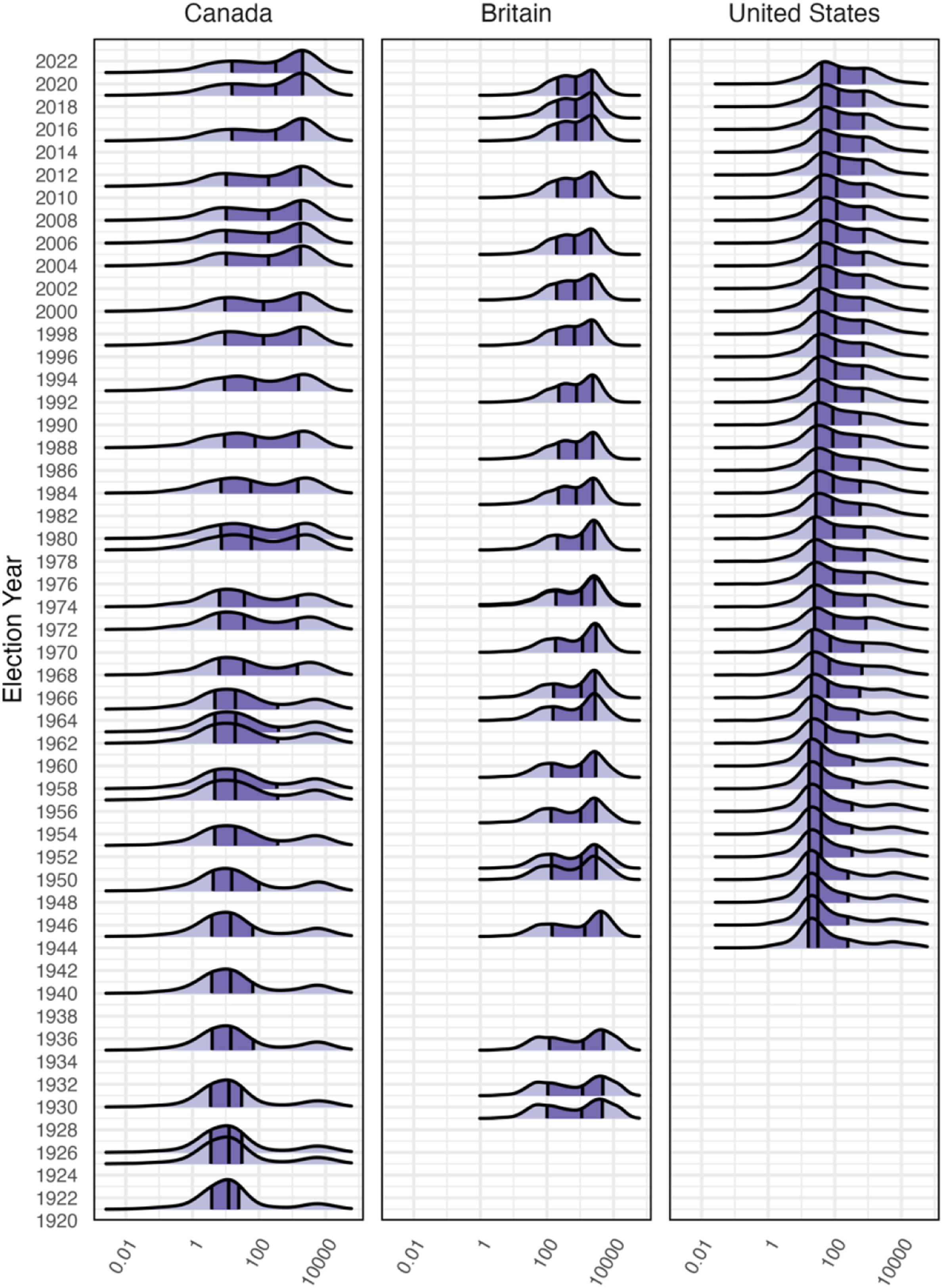
The distributions in Figure 1 reveal variation across countries and time. In Canada, the gradual rightward shift of the mean density lines, and the increasing rightward skew of the density distribution over time, illustrates the gradual urbanization of both the country and legislative representation. The density distributions have always been bimodal, with an ever-decreasing number of low-density districts and an ever-increasing number of higher-density districts. The urban side of this bimodal distribution became dominant in Canada in 1987, reflecting the country’s relatively late urbanization overall. The left tail of the distribution remains long even today due to the small number of very low-density northern districts. Nevertheless, most electoral districts in Canada today are at the ‘urban’ end of the distribution.
Britain’s district density distribution is also bimodal, with a prominent urban peak throughout the entire study period. The average district density has hardly changed. 6 In recent years, however, the middle of the bimodal distribution has filled in, perhaps reflecting electoral boundary commissions’ reduced emphasis on drawing constituencies that respect county and local authority boundaries, and also the rapid growth of the country’s population relative to the number of seats in the House of Commons; as Rodden (2019) argues, larger districts tend to dilute smaller urban centres.
In the United States, we see evidence of a modest shift toward denser districts over time, but also a distinctive leftward skew in the distribution relative to the other countries. In the United States, a small legislature relative to the country’s population, a geographically large country, the strict requirement of equal district populations since 1965, and partisan redistricting efforts that favour rural interests produce large numbers of relatively low-density districts. As a result, American districts have remained disproportionately rural even as the country has urbanized.
The Importance of the Urban-Rural Divide
The density distributions in Figure 1 illustrate the supply of urban and rural districts in each country over time, but how important is this variation in district urbanity for election outcomes? Figure 2 summarizes the results of our analysis of the expected proportional reduction in error (ePRE) associated with the district urbanity model for each election in each country. Each country’s panel summarizes ePRE scores for each election. Election scores are connected with lines to better visualize each country’s longer-term trajectory. Recall that larger values indicate a larger proportional reduction in error associated with the model containing district population density – when the ePRE score is higher, in other words, district density is more valuable for predicting election outcomes, and the urban-rural divide is thus more important for understanding which parties won and lost in the election. Estimated proportional reduction in error due to Urbanity.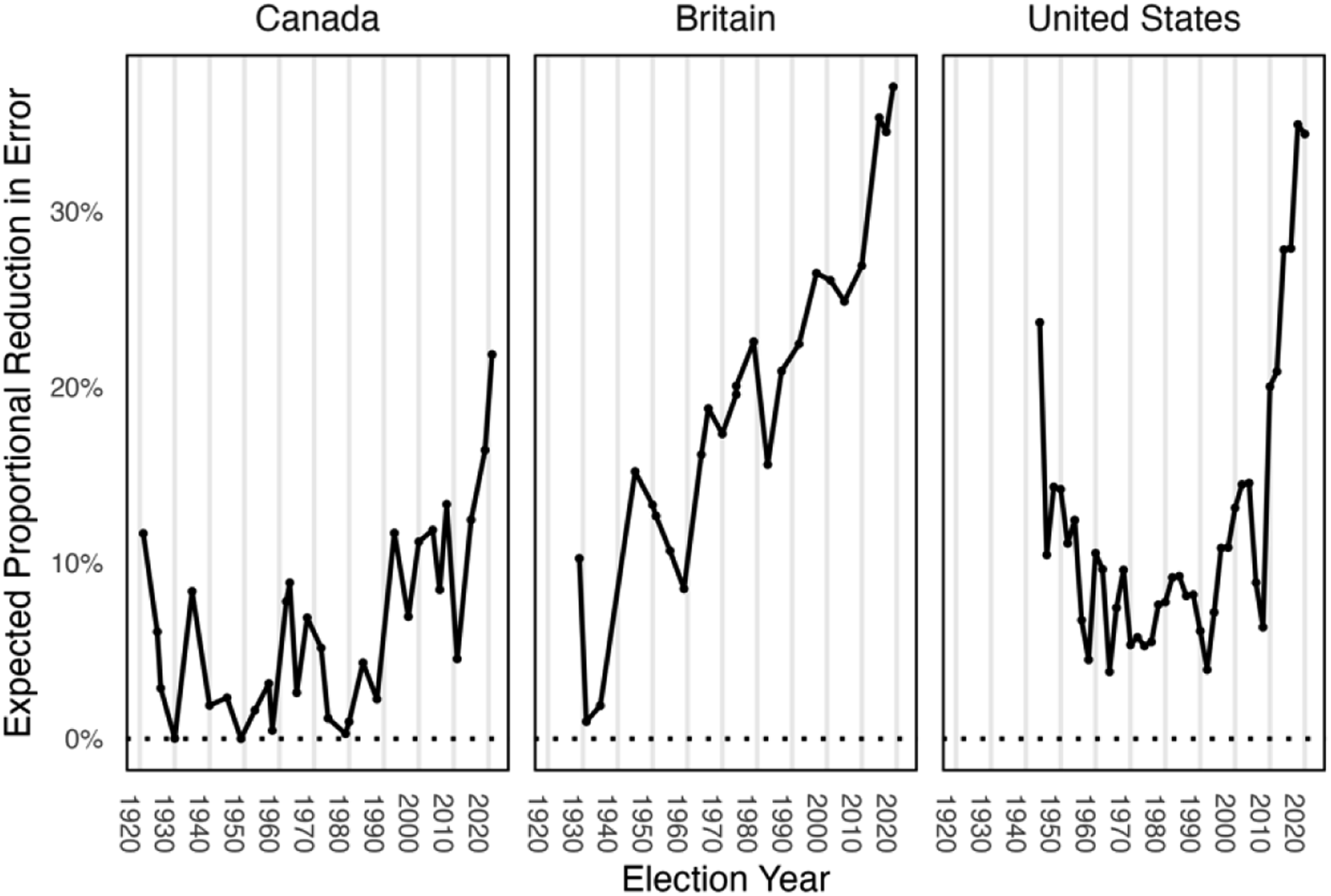
The results in Figure 2 suggest that the development of the urban-rural divide has followed a distinctive trajectory in each country. In Canada, the importance of the urban-rural divide is episodic, with distinct surges in the 1920s, 1930s, and 1960s, and a more consistent pattern of growth since the 1980s. Until the most recent decades, however, ePRE scores return nearly to zero between episodes. In Britain, we see a large and increasing urban-rural cleavage over the study period, with dips during the 1950s, 1983, and 2005–17 periods. (The low values in 1931 and 1935 are produced by emergency coalition governments whose caucuses comprised most seats). Unlike Canada, Britain’s overall trajectory trends upward since 1928; following each dip, elections return to ePRE values substantially above where they were before. Compared to Canada, the importance of the urban-rural divide in British elections has been ratcheting upward over a much longer period.
The pattern is very different in the United States. Between 1940 and 1970, the ePRE scores are especially volatile, oscillating between peaks and valleys with an overall downward trajectory. In this era, the two parties’ geographic patterns of electoral dominance were reinforced by gerrymandered districts and, especially in the South, voter suppression, but disrupted by rapid urbanization, population movements, and the erosion of the New Deal settlement. The landmark court decisions of the 1960s, which required equal district populations, expanded voting rights, and restricted racial gerrymandering, enabled the parties to better compete on each other’s turf. The values move episodically, without any obvious upward or downward trend, from the late 1960s until the early 1990s, when they move sharply upward again. With the exception of the 2006 and 2008 elections, this sharp upward trend has continued, with very high ePRE values in the country’s most recent elections.
One noticeable feature of the results in all three countries is the especially high ePRE values in recent elections. Figure 3 reinforces this finding by plotting the ten highest ePRE scores in each country along a timeline from the 1920s to the present. Each election is labelled with its overall rank (lower values indicate higher ePRE scores), with darker shades indicating elections in which the urban-rural divide was most important. What is most noticeable in the figure is the clustering of high values in more recent elections. Of the ten elections in which the urban-rural divide is most important for understanding election outcomes, eight have occurred since 1990 in all three countries. Even more strikingly, the very highest ePRE scores are among the two most recent elections in each country. Thus, despite important differences in the long-term trajectories in Figure 2, the overall rankings in Figure 3 illustrate that the urban-rural divide has become more salient in all three countries in recent years. The ten highest ePRE scores by country.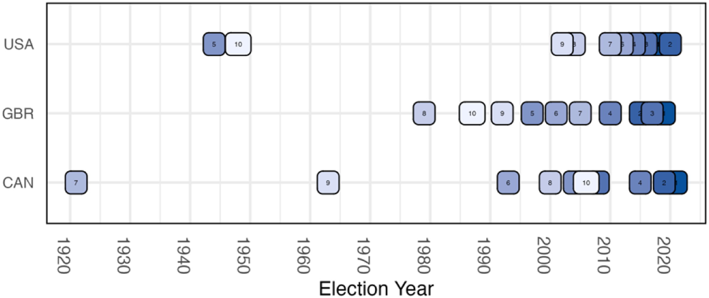
The Urban-Rural Divide in National Party Systems
Our ePRE analysis suggests that the urban-rural divide has been an important predictor of election outcomes in all three countries, especially in more recent elections. However, the trajectories by which each country has arrived at this point, and the timing of episodes in which the urban-rural cleavage is stronger or weaker, are quite distinctive. In this section, we provide a brief description of the long-term development of the urban-rural divide in each country and draw on secondary literature to interpret the observed patterns using the framework introduced earlier in the article.
To enrich these descriptive vignettes, Figure 4 summarizes the relationship between party vote share and district urbanity for each election in each country. As we discussed earlier, this analysis focuses only on major parties that have contested elections in all or nearly all districts. We record coefficient estimates with coloured lines and 95% confidence intervals with the shaded regions. When the solid lines and associated shaded regions are above the horizontal zero line, this indicates that the party performed significantly better in the most urban districts than in the least urban districts in that election. When the line and shaded region is below the zero line, the party does better in less urban (i.e., more rural) districts than in urban districts. The vertical axis can be interpreted as the party’s expected difference in vote share when moving from the least urban to the most urban district in a particular election, controlling for regional variation in party support. Expected shift in party vote share, lowest density to highest density district.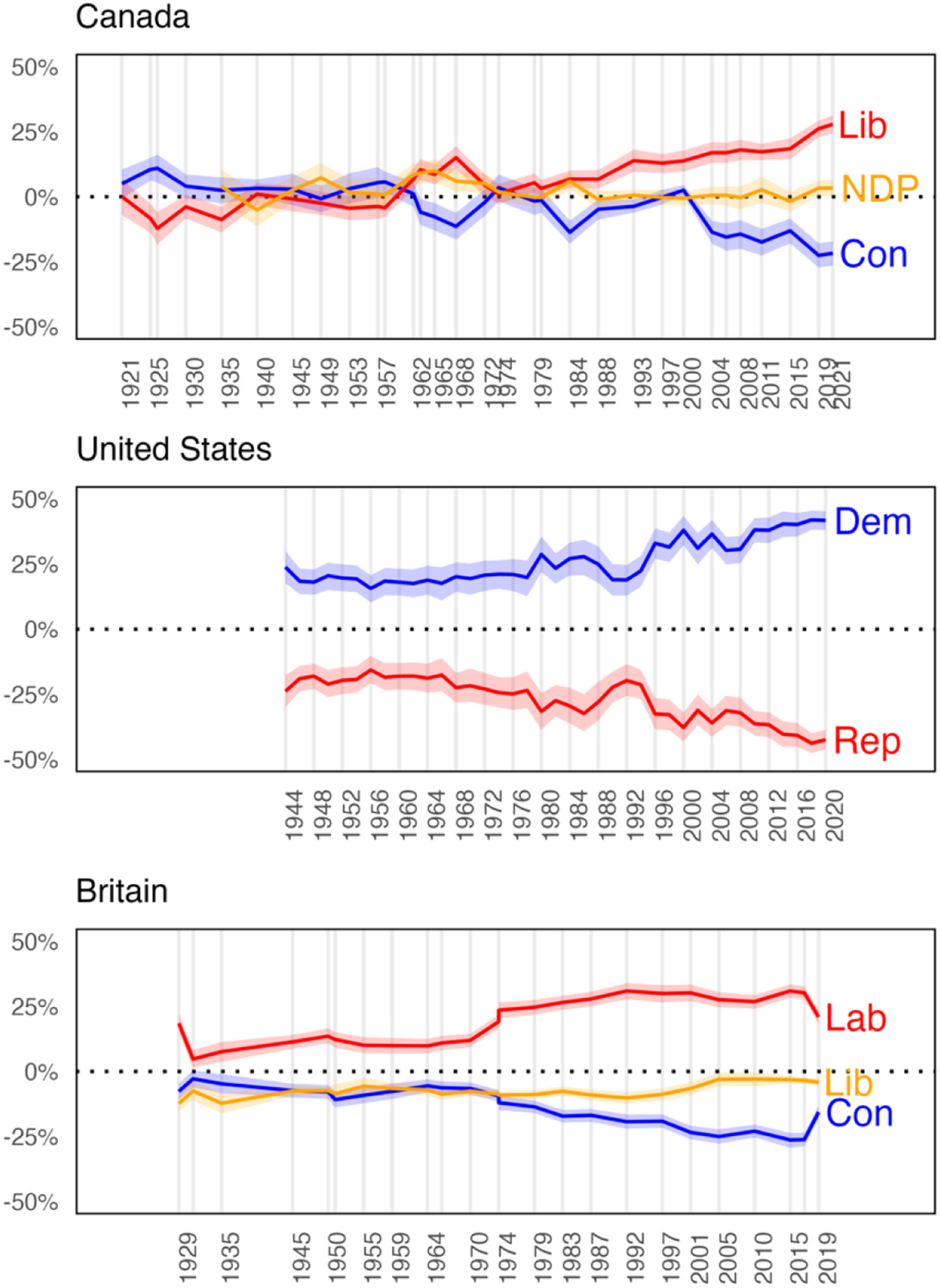
The United States
Figure 4 shows a persistent, symmetrical, and widening division between an increasingly urban Democratic party and increasingly rural Republican party over the postwar period. Nationally, the gap between the two parties steadily increased between the mid-1950s and late 1980s before moderating during the early 1990s. It then further increased through the George W. Bush, Obama, and Trump presidencies to unprecedented levels. This finding is consistent with analysis by Ogorzalek (2018, p. 214), who finds that after 1965, approximately 75% of city representatives were Democratic, and between 40 and 50% of the Democratic caucus came from city districts.
In McKee’s (2008), Mettler and Brown’s (2022), and Hopkins’ (2017) tellings, the realignment of the Democratic ‘Solid South’ to a Republican bastion established the conditions for the emergence of a national urban-rural cleavage as the parties’ alignments with urban and rural interests converged and consolidated across regions. Through this transformation, the urban-rural cleavage subsumed sectionalism. Figure 5 illustrates the regional articulation of the urban-rural divide. The Democrats’ modest urban bias after the Second World War was the product of its strong support, consolidated during the New Deal, from big-city ethnic ‘machines’ and organized labour in the North and Midwest (Ogorzalek, 2018). The Republican bias toward the rural in the 1940s and 1950s reflected the party’s relative strength among proprietors and smallholders in Northern small towns and rural areas. Expected shift in party vote share, lowest density to highest density district, USA by region.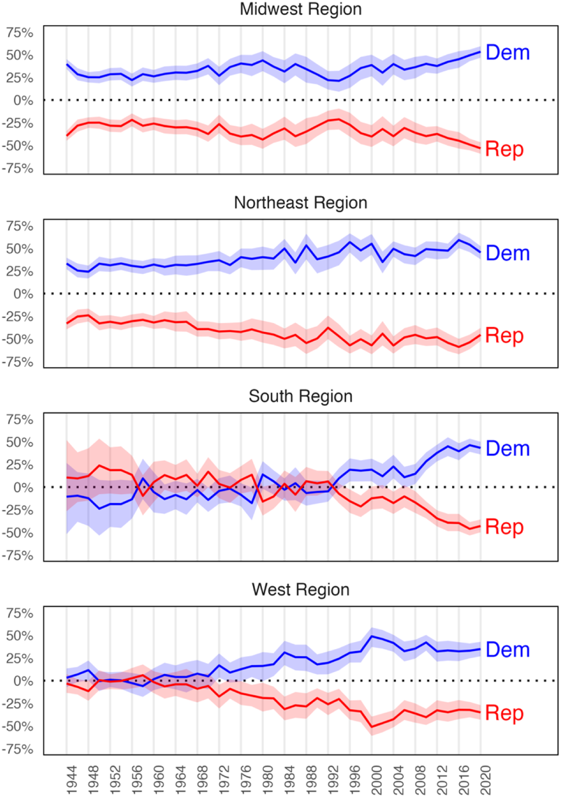
The parties’ urban and rural biases in the North have intensified over time as Northern Democrats’ economic liberalism and embrace of civil rights made African-Americans a core component of the Democratic electoral coalition (Schickler, 2016), and the Second Great Migration, immigration, and ‘White flight’ transformed the ethno-racial composition of Northeastern and Midwestern cities (Boustan, 2010). By 2000, 55% of Blacks lived in central cities nationally, compared to 22% of non-Hispanic Whites (McKinnon, 2003, p. 2). Across all metropolitan statistical areas, whites comprised 77% of the aggregate central-city population in 1970, but only 50% in 2010 (Massey & Tannen, 2018, p. 1600). As reliable Democratic voters – first white ethnics and unionized industrial workers, then Blacks, Latinos, knowledge workers, and public-sector labour – became increasingly concentrated in urban areas in the postwar period, the Republican base became whiter and less urban. The urban-rural gap between the parties has increased since 2000 in the Midwest, where it is now wider than at any point since the Second World War.
These compositional dynamics played out differently in the South and West. As Key (1962, p. 229) noted, American governing coalitions were historically assembled from sectional building blocks. The long Democratic hegemony in Congress during the New Deal and early postwar periods was underwritten by agreement between Northern (urban) labour and Southern (urban and rural) whites on matters of trade and economic development policy, while submerging racial oppression in the South. Northern Democrats’ embrace of civil rights fractured this coalition. Republicans seized this opportunity to capture the white South (Flynt, 2002). This is clearly visible in Figure 5. The inversion of the parties’ urban-rural support occurred gradually. In 1956, when the Supreme Court desegregated schools, Democratic Party representation in the South was based in rural areas. By the time of Reagan’s victory in 1980, following Goldwater’s and Nixon’s activation of white racial resentment in earlier campaigns, neither party was biased toward the urban or the rural in the South. Starting the 1990s, however, an urban-rural partisan gap akin to that observed elsewhere in the country emerged and expanded.
For its part, the emergence of an urban-rural divide in the Western region since the 1970s reflected the conjuncture of rapid Sunbelt urbanization and Democrat-voting minorities’ increasing share of metropolitan and especially central city populations, all of which rendered the Western states more like the other regions.
The stark political cleavage that has opened since the 1990s is the product of rapid social and economic changes that have intensified the compositional and contextual differences between urban and rural areas (Manyika et al., 2012; Parker et al., 2018). City populations are increasingly more educated, younger, economically productive, and racially diverse than rural areas. While metropolitan areas are experiencing rapid, immigration-fuelled population and employment growth, rural populations are declining. Urban and rural residents’ attitudes now diverge on a wide range of issues, including marriage equality, the desirability of immigration, and perceptions of groups in society (Gimpel et al., 2020). The ‘culture wars’ that have emerged since the 1970s, and intensified since the 1990s, represent the strategic activation of increasingly place-based issues and identities by opportunistic elites, largely on the Republican side (Cramer, 2016). The urban-rural divide also reflects the decline of the personal vote and the nationalization of American politics. Vote choice is increasingly driven by party identification rather than by local candidates’ personal appeal or following, a process driven by the delocalization of media and the economy and the nationalization of issues (see also Holliday, 2022; Hopkins, 2018). The Democratic Party’s loss of 63 seats and control of the House in the 2010 midterm elections is credited to opposition to President Obama’s signature health care and stimulus bills, for example. In that election, the Democrats lost seats in all regions, and especially in rural and suburban areas of the Midwest and South (Edison Research, 2010). Party system nationalization amid geographically concentrated partisanship and a district-based electoral system is a recipe for the entrenchment of territorial cleavage.
In sum, the literature suggests that the observed widening of the urban-rural divide in the United States is the product of both compositional and contextual effects. The divide is reinforced by the zero-sum nature of the two-party system, whereby partisanship assimilates highly correlated sets of opposing positions on a wide range of issues (Klein, 2020; Mason, 2018), and by elites’ strategic activation of place-based issues and identities.
Great Britain
Earlier we noted that the urban-rural cleavage in Britain has grown since the early 20th century. Figure 4 shows that this manifests primarily as a divide between the Labour and Conservative Parties, which together attracted the vast majority of votes cast in 20th century elections. Scholarship on British electoral behaviour, especially regarding the pre-1970 period, has emphasized class as the primary determinant of vote choice. Electoral geography in this period is therefore largely associated with the clustering of individuals with similar characteristics. As Johnston and Pattie (2009, p. 1867) put it, ‘Once you knew where the different classes lived, you could predict with considerable accuracy which party would win which constituency – and also whether it would be won easily, or the contest would be close, depending on the constituency’s class composition’. Thus, as shown in Figure 4, Labour’s persistent urban bias is the product of its roots in urban industrial trade unionism, and the Conservatives’ opposing bias stems from the party’s historical development as the champion of landowners, agrarian and industrial interests, and, especially since the 1970s, small proprietors and entrepreneurs in the towns and cities (Grant, 1980).
Nevertheless, Figure 4 reveals two aspects that must be explained. First, the relationship between district urbanity and vote share for Labour and the Conservatives is asymmetrical. Labour’s bias toward the urban has always been stronger than the Conservative Party’s bias toward the rural. As the Labour Party gained electoral strength in the interwar period, it ‘anchored its expression of national identity in the industrial labour movement’ (Brooks, 2020, p. 796) based in cities and mining towns, leaving the Conservative Party to identify Englishness with pastoral landscapes and rural life. Indeed, between Labour’s 1945 and 1997 landslides, the Conservative Party virtually monopolized rural parliamentary representation (Woods, 2005, ch. 4), framing itself as the defender of the countryside, property rights, and Englishness against the increasingly diverse cities. For its part, the Liberal Party was a marginal force since being displaced by Labour early in the 20th century. After its merger with the Labour splinter Social Democrats in 1988, it received increasing support mostly from ‘a geographical heartland on the “Celtic fringe” and a sociological heartland among the educated middle classes’ (Sloman, 2020, p. 36), increasing its vote share when it succeeded in attracting suburban and small-town Conservative voters – a pattern visible in Figure 4 in the Liberal Democrats’ upward trajectory, and the Conservatives’ downward trajectory, between 1997 and 2010.
Figure 4 also reveals an intriguing temporal pattern. Most of Labour’s urban shift occurred prior to its 1964 victory under Harold Wilson, while most of the Conservatives’ rural shift has occurred since. This is consistent with scholars’ analysis of the shifting class composition of cities, suburbs, and rural areas. In their review of elections between 1955 and 1979, Curtice and Steed (1982) point to the suburbanization of managers and professionals (a Conservative constituency) in the early postwar period and the decline of rural mining (historically a Labour constituency), especially after 1966, as drivers of the changing electoral geography (on the latter, see also Beynon et al., 2021; Martin et al., 1993).
The resurgence of the Liberal Party already discussed, and the rise of nationalist parties in Wales and Scotland starting in the 1970s, also chipped away at historical bases of major party support, sometimes tipping constituency elections in less predictable directions (Johnston et al., 2017, p. 525). Nevertheless, Johnston et al. (2009, p. 614) argue that in the 1950–2001 period, Labour has consistently outperformed the Conservatives in more urban settings – constituencies characterized in their analysis as ‘(Ex-)Mining, Deprived Urban, Manufacturing, and Inner London (where “blue-collar” occupations dominated)’. However, this accompanied the general numerical decline of Labour’s (urban) unionized blue-collar base through deindustrialization and, after 1979, Conservative Prime Minister Margaret Thatcher’s programmatic assault on union rights and marketization of the welfare state. It was not until the 1990s that Tony Blair’s ‘New’ Labour constructed a new electoral coalition based on a ‘one nation’ appeal that attracted not only the remaining mostly public-sector unionized workers, but also middle-class voters in the now-growing urban centres and their suburbs. The past quarter-century has seen increasing social and economic divergence between city and country, as London and, to a less extent, second-tier cities, have run away with population and employment growth and become increasingly diverse (Jennings & Stoker, 2019).
The increase in the urban-rural gap between the Labour and Conservative parties since 2010 has occurred during a time of Conservative government. The collapse of the Liberal Democrats following their electorally disastrous coalition with the Conservatives (2010–15) and the obsolescence of the pro-Brexit minor parties after the 2016 Leave vote sharpened the competition between the two major parties, at least in England, while reducing the number of competitive seats (Johnston et al., 2017, p. 526). In an analysis of voter surveys in the 2015, 2017, and 2019 elections, Curtice (2020) finds that the Conservatives undercut Labour by increasing, election over election, their support among working-class and less educated voters, while also attracting over 60% of the high-turnout senior vote. It is therefore no surprise that the Labour vote has tilted increasingly urban, as its contemporary core constituencies of young people, unionized workers, and educated professionals and managers are concentrated in cities. Indeed, a regional analysis (see on-line Appendix C) suggests that the partisan gap widened the most in regions with larger cities: London, the North West (including Liverpool and Manchester), the West Midlands (including Birmingham), and Yorkshire and the Humber (including Bradford, Hull, Leeds, and Sheffield).
Brexit was a key driver of this partisan realignment. The ‘take back control’ narrative assimilated multiple issues that divide along the urban-rural continuum (Jennings & Stoker, 2019). English voters outside London and other diverse urban growth centres blamed immigrants and labour mobility within the European Union for the declining economic fortunes of rural and small-town Britain (Sobolewska & Ford, 2020). Rising support for English nationalist and pro-Brexit political parties pulled the Conservatives to the right; after Brexit, the Conservative party has been dominated by its right-populist faction. Rhetorically, the Conservatives have positioned themselves as the defenders of ‘real’ Englishness against cosmopolitan London (Brooks, 2020), despite many Tory leaders being members of the metropolitan professional class. For its part, Labour has struggled to mount a coherent response.
In sum, British electoral behaviour is viewed as largely driven by class, and therefore electoral geography is to an important extent a manifestation of the class composition of districts, which in turn has been profoundly reshaped by macro-economic and social transformations: deindustrialization, the rise of the knowledge economy, and migration. Still, elite appeals and agendas matter. Labour’s appeal to the emerging urban professional class was important to its success in 1997 and subsequent elections, much as the Conservatives’ national-populist appeal to rural and small-town ‘left-behind’ white voters contributed to their 2019 landslide.
Canada
The ePRE analysis in Figure 2 suggested, and the vote share analysis in Figure 4 reinforces, an episodic interpretation of the urban-rural divide in Canada. The first discernible urban-rural division began amidst the fractious politics of the First World War, as anxious farmers – who nervously trusted, and were then betrayed by, a Conservative-led ‘Unionist’ coalition – revolted against established parties and turned their support to upstart United Farmers and Progressive Parties (Morton, 1950; Young, 1972). By the 1920s, this agrarian impulse had largely been absorbed into the Liberal Party (Johnston et al., 1992).
The urban-rural cleavage reappeared, this time more durably, in the early 1960s. This episode began with the extraordinary success of Conservative Prime Minister John Diefenbaker, whose prairie populism, progressive policy promises, and contempt for central Canadian urban elites powerfully reshuffled the Conservative Party’s traditional support coalition (Courtney, 2022; Regenstreif, 1965; Smith, 1997). Both the Liberal Party and the New Democratic Party responded to the upheaval of the Diefenbaker years by transforming their parties’ external image and internal operation; the transformation was deeper and more durable for the Liberals, whose urban vote share advantage, first acquired in 1962, reappeared in every election thereafter (Surich, 1975; Wearing, 1981; Young, 1964).
While the Liberal Party’s urban advantage was stable after 1962, the Conservative Party followed a different path, with extended periods in which the party’s rural advantage either disappeared or was substantively small. In the late 1960s and early 1970s, these periods reflect the party’s attempts to shed Diefenbaker’s anti-metropolitan legacy. In the 1990s, they reflect the party’s diminished status and migration to the centre in the face of the Reform Party, a transitory right-wing insurgent party that captured much of the Conservatives’ western rural base, and the Bloc Québécois, which won many rural Québec seats (Flanagan, 2009; Johnston, 2017). In 1997 and 2000, vote-splitting between the Conservative and Reform parties handed the Liberals many victories in rural Ontario.
By the 2004 election, following more than a decade of Liberal Party dominance, the Reform Party (by then called the Canadian Alliance) had merged with the rump Progressive Conservative Party, creating a new Conservative Party whose ideological flavour and geographic base of support was much more the heir of Reform than of the Progressive Conservatives of earlier decades. Only after this point did a truly symmetric and growing divide between the two major parties emerge, with the Liberal Party’s vote share becoming ever more urban, and the Conservative Party’s vote share leaning increasingly rural.
Unlike the United States, the development of the urban-rural divide in Canada does not reflect a nationalization of the urban-rural cleavage out of a period of more regionalized politics – in fact, despite some differences in timing and magnitude, the post-war trajectory of the urban-rural divide has been broadly similar across Canadian regions (Armstrong et al., 2022). Instead, the long-term changes appear to reflect dramatic economic and cultural changes to the composition and character of urban and rural Canada, alongside the path-dependent character of the electoral coalitions that the Liberal and Conservative parties have constructed.
Compositionally, Canada’s urban regions are now extremely ethnically diverse, with the three largest metro areas absorbing the overwhelming majority of the country’s large immigration totals each year. While patterns of party support within Canada’s immigrant population are diverse, and the Conservative Party has made serious efforts to attract the immigrant vote, the Liberal Party has enjoyed a longstanding advantage among immigrant voters (Taylor, 2021). The Liberals also have a strong advantage among the highly educated, who are concentrated in cities.
However, the speed with which the urban-rural divide emerged and grew in Canada, both in the early 1960s and more dramatically since the early 2000s, suggests that compositional changes are only part of the story. The appeal of the major party leaders and the two parties’ strategies for constructing a majority coalition in a single member plurality electoral system also clearly play a role. We have already noted how John Diefenbaker’s rural appeal, and the increasing disgust with which he was greeted by the country’s urban elites (fully reciprocated by Diefenbaker), created a new rural base for the party. Even more important, perhaps, were the effects of the Diefenbaker experience on the Liberal Party’s leadership selection decisions and political strategies in the same era: as Diefenbaker dominated rural areas and the Prairies, the Liberal Party elected leaders with appeal in the cities, creating push-pull factors throughout the 1960s which repelled farmers and other rural supporters from the Liberal Party but also attracted middle-class reform-minded urbanites (Wearing, 1981). In the 1980s and 1990s, the path-dependent quality of these pre-existing coalitions combined with an increasingly ideologically structured politics (Cochrane, 2015) to produce an urban-rural divide that is grounded not only in place-based economic differences, but also in urban-rural ideological disagreement, reflected by the major parties, on salient issues including environmental policy, Indigenous-settler relations, and COVID-19 responses.
Conclusion
Our principal purpose in this paper has been to develop methods to enable long-term comparative analysis of the urban-rural divide using available data and to provide a framework with which the historical trajectories that we uncover might be interpreted and compared using secondary qualitative and quantitative evidence. Our analysis has produced two main findings. First, across all three countries compared, the urban-rural divide in voting patterns for national legislatures has increased substantially over time, and is larger and more important today than at any point during the period analysed. Our results confirm the widespread recognition that the urban-rural cleavage has become important for national election outcomes.
We have also found, however, that each country has followed a distinctive pathway to the current moment. Our qualitative comparative interpretation highlights the importance of both compositional and contextual change, intersecting with entrenched regional differences, in the long-term development of the urban-rural partisan divide in each country. In Britain, geographically articulated class cleavages produced an ever-growing urban-rural divide, one propelled to new heights in the Brexit era. In Canada, episodes of urban-rural cleavage emerged and disappeared for decades – a pattern reflecting the country’s late urbanization and profound regional divides – but began to grow more durably in the 1960s and then more sharply in the early 2000s. In the United States, longstanding patterns of urban-rural cleavage in the Midwest and Northeast, rooted in the Democrats’ post-New Deal strength in industrial cities and the Republicans’ relative strength among small-town proprietors and landholders, grew slowly over time, but were balanced by the absence of such divides in the West and cross-cutting cleavages in the South; after the southern realignment, and then the emergence of the divide in the West, the ingredients were in place for a national divide of unprecedented size and scale.
The ebb and flow of the importance of the urban-rural partisan divide is explainable, at least in part, by the actions of party elites who have at different times strategically activated conflict on urban-rural lines for partisan gain. As discussed, Republican politicians from Goldwater to Trump have inflamed rural grievances and racial resentment, even as the social and economic geography of the country polarized, thereby capturing the white South from the Democratic coalition. More recently, British Conservative politicians have breached the ‘Red Wall’ of northern Labour seats through direct appeals to white English voters in declining areas. In Canada, the leading party of the right has at times railed against metropolitan elites while avoiding race-based appeals, and, partly in reaction to the Liberal Party’s dominance of the cities, has consolidated a strong base of support in much of rural Canada.
While these dynamics are nationally idiosyncratic, some compositional and contextual trends are common to the three cases, suggesting that global economic and social transformations have fuelled the urban-rural divergence. Since the 1990s, cities are increasingly where most national population and employment growth occurs, propelled by immigration and agglomeration, while rural areas have experienced relative or absolute decline. As a result, cities are generally wealthier, more diverse, and more highly educated than rural areas across the Global North. Party elites have responded to these transformations with appeals on growing socio-economic polarization along urban-rural lines in recent years. The result is today a wider partisan gap in each country, relative to its own past, than ever before.
Of course, fully assessing these possibilities – and disentangling the exogenous and country-specific mechanisms that have generated the especially large urban-rural divides we see today – will require considerable additional quantitative and qualitative research. We conclude by identifying several priorities for future work.
First, as data availability permits, it would be valuable to expand the comparison to include other democracies that have experienced similar socio-demographic and economic shifts – for example, Germany, France, and Australia. Careful analysis of the interaction between these countries’ different electoral systems, the social and economic geography of urbanization, mass value change, and discourse of party elites would clarify the mechanisms that link macrostructural changes to political behaviour and illustrate the degree to which institutions encourage or frustrate the production and reproduction of the urban-rural cleavage in national politics. Our approach to measuring the importance of the urban-rural divide – which focuses on the role of district urbanity as a predictor of who wins and loses elections – can be usefully extended to other cases in which legislators are elected from geographic sub-districts. By focusing our primary attention on the parties that actually win elections in urban or rural districts, we see our ‘importance’ measure as a practically feasible approach to comparative studies of urban-rural divides that also connects directly to theoretical concerns about the consequences of urban-rural divides for political representation, party system development, and public policy outputs.
Second, more detailed research on these and other cases would reveal more clearly the institutional mechanisms through which the urban-rural cleavage becomes politically salient. We hypothesize that in single-member plurality electoral systems, urban-rural political polarization is reinforced as parties’ organizational presence ebbs in areas where they become uncompetitive. Moreover, we expect that as party caucuses become more homogenously urban (or rural), they lose the ability to recognize and address rural (or urban) problems and become less willing to compromise their core support by cooperating with their opponents across the aisle (Rodden, 2019).
Third, further analysis could explore the interaction between electoral district boundaries and the urban-rural cleavage. Rodden (2019) convincingly argues that large-population districts dilute the influence of urban settlements that are smaller than the average. To what extent do the United States’ exceptionally populous districts contribute to the extraordinary level of urban-rural polarization compared to Britain and Canada? There is also the matter of gerrymandering. Where district boundaries are drawn by legislatures as opposed to arm’s-length bodies, governing parties can manipulate boundaries to their advantage, entrenching rural overrepresentation where it already exists.
Supplemental Material
Supplemental Material - The Development of the Urban-Rural Cleavage in Anglo-American Democracies
Supplemental Material for The Development of the Urban-Rural Cleavage in Anglo-American Democracies by Zack Taylor, Jack Lucas, David A. Armstrong, and Ryan Bakker in Comparative Political Studies
Footnotes
Acknowledgments
The authors are grateful to the following research assistants for their work on different aspects of this project: Moira Benedict, Tyler Girard, Christopher Hewitt, Amanda Miknev, and Kandys Paterson. We are grateful for the assistance of Danny Dorling and Charles Pattie in locating British data and to Jonathan Rodden and Jacob Hacker for thoughtful comments on an earlier version. This work is based in part on data provided through ![]() and uses historical material which is copyright of the Great Britain Historical GIS Project and the University of Portsmouth. Contains National Statistics data © Crown copyright and database right 1983, 1991, 1997, 2005, 2010.
and uses historical material which is copyright of the Great Britain Historical GIS Project and the University of Portsmouth. Contains National Statistics data © Crown copyright and database right 1983, 1991, 1997, 2005, 2010.
Declaration of Conflicting Interests
The author(s) declared no potential conflicts of interest with respect to the research, authorship, and/or publication of this article.
Funding
The author(s) disclosed receipt of the following financial support for the research, authorship, and/or publication of this article: This project was supported by Social Sciences and Humanities Research Council of Canada Insight Grant #435-2019-0224 and internal seed grants from the Faculty of Social Science, University of Western Ontario.
Data Availability Statement
The data given this article are replication materials and code can be found at ![]() .
.
Supplemental Material
Supplemental material for this article is available online.
Notes
Author Biographies
References
Supplementary Material
Please find the following supplemental material available below.
For Open Access articles published under a Creative Commons License, all supplemental material carries the same license as the article it is associated with.
For non-Open Access articles published, all supplemental material carries a non-exclusive license, and permission requests for re-use of supplemental material or any part of supplemental material shall be sent directly to the copyright owner as specified in the copyright notice associated with the article.