
Abstract
P-12 geography courses are often taught as a body of facts students should learn in order to be geographically literate. Geographers, however, typically think of their discipline as encompassing practices and core concepts that help people make sense of the world around them. In this article, we consider three teachers’ pedagogical content knowledge in geography, specifically their knowledge and application of a problem-based geographic inquiry (PBGI) framework. We discuss the extent to which their classroom instruction reflected geographic practices and the cornerstones of geographic inquiry over the course of two years. Our findings suggest that 1) encouraging students to think beyond their current sense of place requires teachers to have a strong grasp of the cornerstones of geographic inquiry, 2) helping teachers to use PBGI strategies to promote geographic thinking for citizenship requires more models of exemplary practice than are currently available, and 3) developing pedagogical content knowledge for geography via professional development is critical but uniquely challenging.
Keywords
Students’ lives are increasingly impacted by complex problems of national and global scale. The study of geography offers great potential for helping them prepare to navigate these problems as citizens. The discipline provides critical factual knowledge, concepts, and theories that might allow people to better understand the context of social problems (Heffron & Downs, 2012). Geographers commonly explore the spatial and ecological dimensions of problems, for instance, but other perspectives can be used as well (Heffron & Downs, 2012). The power of geography to support effective citizenship is evident, but Thornton (2019) notes the curriculum “must be marshaled to the task” if it is to be effective in this regard (p. 11).
To pursue geography teaching for citizenship goals, teachers must possess deep knowledge of core geography concepts along with geographic inquiry practices that can be used to structure inquiry for citizenship purposes. The transition to inquiry-based instruction is challenging for most teachers, and research suggests that geography educators continue to rely on traditional instruction for a variety of reasons (Knowles & Theobald, 2013). In 2015, in the wake of calls for studies of exemplary geography teaching (Bednarz et al., 2013) and calls for professional development (PD) to promote exemplary geography teaching practices (Schell et al., 2013), we initiated the Bridging Divides Project to investigate ways to support teachers in enacting a specific inquiry-based model we refer to as problem-based geographic inquiry (PBGI). Distinctions between PBGI and other well-known inquiry models like the C3 Framework are subtle, but worth exploring as context for understanding the rationale behind our project. First, in PBGI, emphasis is placed on engaging students in the investigation of national and international public issues debated by citizens and policy leaders. Compelling questions (NCSS, 2013) and geoinquiry questions (National Geographic, 2018) can have a similar focus, but this is not a requirement.
Additionally, we seek to align topics selected for in-depth inquiries with broader persistent issues that consistently impact democratic societies (Saye & Brush, 2004). Linking instruction to persistent issues creates cohesion across units within a course allowing students to better envision how topics have contemporary relevance for democratic citizenship. Using persistent issues also supports connections across the broader social studies curriculum since teachers can work together to ensure the same persistent issues are explored across grade levels. In this way, the model helps teachers to make informed decisions regarding which topics to explore in-depth in an often crowded list of standards. The most used version of the inquiry design model (IDM), based on the C3 Framework, organizes instruction around compelling and supporting questions (Grant et al., 2017). However, these IDMs do not necessarily emphasize connections to broader overarching questions that cut across social studies subjects and grade levels.
Several other important aspects of our problem-based model are noteworthy. Problem-based geographic inquiry units emphasize disciplinary thinking in geography and jurisprudential reasoning, grounded in the work of Oliver and Shaver (1966). The jurispru-dential approach to inquiry guides learners to deeply analyze questions citizens confront and consider how values shape public policy (see example provided in Kohlmeier, 2021). Since our focus is on both geography and citizenship, PBGI units tend to feature a broader range of instructional strategies and learning experiences than might be found in geoinquiries or C3-based inquiries. The teacher typically provides the ill-structured question or problem for the unit and promotes guided, collaborative deliberation about persistent social issues (Saye & Brush, 2004).
The integrative and value-based aspects of the jurisprudential model make it attractive for use in social studies classrooms today, particularly since these elements are also emphasized within the NCSS Vision of Powerful Teaching and Learning in the Social Studies (National Council for the Social Studies, 2016). Problem or issues-based curriculums grounded in the jurisprudential model have been studied and refined over the course of many years (Kohlmeier et al., 2020; Kohlmeier & Saye, 2014; Newmann & Oliver, 1970; Parker, 1989; Saye et al., 2009). However, this research has mainly occurred in history and civics/government settings. Our PBGI model builds off this research base and seeks to equip learners with the ability to think like geographers and weigh the ethical dilemmas embedded in persistent social issues.
In this article, we describe the experiences of project teachers as they sought to design and implement a unit of instruction that leveraged geography to achieve citizenship learning goals. We hoped to identify barriers to this work so that social studies teacher educators and PD leaders might improve efforts to help teachers pursue citizenship aims in their geography teaching. We use a case study approach to convey findings related to two research questions:
Research Question 1: To what extent did project teachers implement instruction consistent with the problem-based geographic inquiry model?
Research Question 2: What can social studies teacher educators and professional developers do to better help teachers engage in this type of instruction?
In other work, we have carefully examined the designed curriculum, including the principles that guided its development (Maddox & Howell, 2018). In this paper, we provide enough context about the curriculum to understand the findings but do not consider the curriculum in depth. While student products were collected and examined during observations and discussed during observation debriefing meetings, student learning is also not the focus of this paper. Given our goal of introducing teachers to PBGI and helping them to link instruction to citizenship aims, we focused our PD efforts and subsequent analysis on the teachers’ use of broad cornerstones and practices embedded within geography.
Literature review
In this section, we synthesize the research that informs our approach to designing geographic inquiries that prioritize citizenship learning goals. We initially situate our model within scholarship in geography education pertaining to inquiry-based instruction and best practices for teaching geographic thinking and reasoning. This research provides the basis for ensuring inquiries effectively build the capacity of students to think like geographers. Next, we consider research in problem or issues-based learning in geography that focuses on democratic citizenship. These studies convey a need for more research focused specifically on geography teachers as they seek to modify their practice and enact high quality problem-based learning. We conclude by discussing problem-based geographic inquiry (PBGI) and our goal of building teachers’ pedagogical content knowledge (PCK).
Developing geographic thinking and reasoning skills
Leading geography educators advocate a balanced curriculum that preserves the traditional focus on teaching geographic content but embeds this instruction within inquiry activities that cultivate mastery of concepts and reasoning skills (Schell et al., 2013). Since geographers seek to “understand how people interact with their environment in places” (Gersmehl, 2014, p. 141), their work often involves inquiries that emphasize location. Put succinctly by Gritzner (2002), geography involves “What is Where, Why There, Why Care?” (p. 38). In seeking to better explain what it means to do geography, geography educators have identified six categories of geographic practice that parallel the inquiry-arc of the C3 Framework. These include 1) posing geographic questions, 2) acquiring geographic information, 3) organizing geographic information, 4) analyzing geographic information, 5) answering geographic questions and designing solutions, and 6) communicating geographic information (Bednarz et al., 2013).
If learners are to engage in geographic practices, teachers must guide them to develop knowledge of disciplinary ideas pertaining to location, condition, connection, and spatial reasoning, what Gersmehl (2014) calls the “cornerstones” of geographic inquiry. Some sources add human-environment interactions to this list and use different terminology (e.g., place used instead of condition), however geographers generally view the discipline as emphasizing similar “core” ideas (see Schell et al., 2013, p. 22). When learners explore these core disciplinary ideas during geographic inquiries, they should gradually develop an expanding array of knowledge and tools that permit more sophisticated thinking and reasoning. Students best derive deep meaning from geography instruction when they consider geographic content, theories, and values together (Gersmehl, 2014).
Geographic content knowledge plays a key role in effective thinking and problem-solving. Inquiry-based units offer extended opportunities for students to work with geographic terms and concepts within real world contexts. As students develop expertise working with foundational geographic ideas, they should begin to be able to engage in automatic processing and attend to more aspects of a complex problem without experiencing cognitive overload (National Academy of Sciences, Engineering, & Medicine, 2018).
Geographic inquiries also support students’ capacity to engage in geographic thinking and reasoning by encouraging exploration of theories. The practice of analyzing geographic information often involves “constructing an explanation or prediction for phenomenon by comparing data to a model or theory” (Schell et al., 2013, p. 28). Students become more effective problem solvers when they are aware of and able to use applicable geographic models that relate to various issues (e.g., the demographic transition model for understanding population growth). Application of geographic models and theories represents the complex thinking required to solve many of the world’s most pressing challenges including climate change, human migration, and poverty.
Finally, learners often confront values when they design and evaluate solutions to geographic problems (Gersmehl, 2014; Mitchell, 2018). This aspect of geographic thinking and reasoning has relevance for our model of problem-based geographic inquiry since it focuses on examinations of ill-structured issues within a jurisprudential framework. Hopwood (2008), for instance, describes how controversial issues instruction can easily fit into the geography curriculum and result in a complex range of outcomes for students. Geographic inquiries ultimately feature a progression of steps consistent with the geographic practices and allow learners to explore a range of problems that share an emphasis on “place.”
Teaching geographic thinking
We have described a vision of secondary geography instruction that supports learners in developing increasingly sophisticated geographic understandings and problem-solving tools while engaged in inquiries involving the geographic practices. In this section, we turn to the literature on how to teach these skills with emphasis on studies involving problem-based learning. Efforts to improve the teaching of geographic thinking are primarily informed by cognitive development studies (Uttal, 2000), neurological studies of spatial reasoning (Hegarty et al., 2006; see also; Gersmehl & Gersmehl, 2007), expert/novice comparison research (Anderson & Leinhardt, 2002; Liben & Downs, 1989), and laboratory studies designed to evaluate specific disciplinary thinking competencies (Wiegand, 2003). The lack of large-scale classroom-based research describing best practices for effectively teaching geographic practices and reasoning has been noted as a weakness in geography education (Bednarz et al., 2013; Saye, 2017). However, quality research is available to guide teachers and curriculum designers in developing lessons that target specific thinking and reasoning competencies (e. g. related to map reading). Curriculum exemplars and case studies are also available that provide evidence of the types of positive learning outcomes that can be achieved in secondary settings when students have the opportunity to engage in thoughtful inquiries using a variety of inquiry models (Audet & Ludwig, 2000; English & Feaster, 2003; Malone et al., 2002; Oberle, 2020).
Problem-based learning
Curriculums more specifically designated as problem or “issues-based” are also advocated by geography educators (Bednarz, 2000; Weiss, 2017; Yeung, 2010). Appendix A highlights several geography curriculums and projects that fit into this category and emphasize citizenship learning goals. The Geographic Inquiry into Global Issues (GIGI) curriculum most closely fits our model (Hill, 1993). GIGI materials were evaluated during national trials in the early 1990s and the results provide some evidence of the curriculum’s effectiveness with secondary learners (Klein, 1995). We particularly endorse this curriculum’s emphasis on having students explore persistent societal issues such as “diversity and unity, spatial justice, quality of life, territorial conflict, interdependency, and environmental stability and change” (p. 74). The Choices Curriculum (Watson Institute for International & Public Affairs, 2018) for geography is also an important contemporary of our model due, in part, to its intentional use of deliberative activities and simulation-based role plays. This curriculum challenges students to consider policy questions from multiple perspectives, to reason with peers about policy options, and to use geographic knowledge and skills to support their conclusions. Finally, more recent work by Schlemper et al. (2018, 2019) also contributes to the research base on problem-based learning in geography with secondary learners. The PBL model used in this project contains multiple parallels with our own to include an emphasis on collaborative problem-solving and exploration of authentic issues using disciplinary tools. The experimental curriculum, implemented in summer workshops involving learners in grades 7-12, increased students’ awareness of local problems and the ways geospatial technologies can be used to better investigate solutions (Schlemper et al., 2019).
Problem-based geographic inquiry
A PBGI unit is organized around an ill-structured, open-ended central question related to a geographic topic. This central question acts as a manifestation of a larger persistent social issue. It serves as the spine of an instructional unit that drives towards a performance assessment. The performance assessment requires students to apply disciplinary knowledge to answer the question, usually by making an evidence-based decision. In lessons within the unit, learners actively work with rich sources of geography content through a variety of student-centered instructional strategies. At the heart of the framework is a desire to promote civil discourse and democratic decision-making that prioritizes the common good.
PBGI is underpinned by research on Authentic Intellectual Work (Newmann et al., 2016) and constructivist theories of learning. It is also informed, as previously mentioned, by the jurisprudential model of instruction (Newmann & Oliver, 1970; Oliver & Shaver, 1966; Saye & Brush, 2004). We utilize design principles derived from this research/theory base to inform our decision-making during curriculum development. These design principles are explained in our previous research (Maddox & Howell, 2018) and included in Appendix B.
Our goal in this study is to support geography teachers in designing and field-testing a PBGI curriculum by providing PD based on a Japanese lesson study process. Modified planning scaffolds first developed in earlier social studies PD projects (e.g., Kohlmeier & Saye, 2014; Saye & Brush, 1999, 2007) were used to guide participating teachers through the design process and encourage frequent consideration of the design principles. Additional adaptations were made to these scaffolds to support teachers’ development of geography-specific pedagogical content knowledge. Research suggests the transition to inquiry-based instruction from more traditional forms of pedagogy can be challenging due to various barriers (for a summary of the barriers, see Saye, 2017). The scaffolded lesson study process has shown promise in helping teachers overcome some of these barriers and integrate problem-based historical inquiry, to varying degrees, into their practice (Saye et al., 2009, 2017). This research suggests similar results are possible in geography.
Little classroom-based information is available that focuses specifically on barriers or challenges that face geography teachers as they plan and enact problem or issues-based inquiry in secondary settings (see Appendix A). Studies that examine teachers’ use of core tenets of geographic inquiry and geographic thinking within PBL units are even rarer. By identifying barriers to problem-based geographic inquiry and identifying strategies that might assist geography teachers in building pedagogical content knowledge to overcome these barriers, our research addresses a need in the field, including calls for supporting the PD needs of geography educators (Schell et al., 2013).
Theoretical framework
Broadly speaking, Shulman’s (1987) notions of pedagogical content knowledge (PCK) served as the theoretical framework guiding our study. For geography teachers to use geographic practices to help students think geographically, they must have adequate pedagogical content knowledge (Shulman, 1987). In other words, teachers must not only have deep knowledge of geography and geographic reasoning skills, but also be able to translate that knowledge into instructional experiences that encourage students to think geographically about social issues. In recent years, Shulman’s notions of PCK have been refined. Ball et al. (2008), for instance, have suggested that teachers must have specialized content knowledge (knowledge and skill from the content area that is unique to teaching). Teachers need to be able to flexibly unpack disciplined thinking to make quick decisions about problems and examples that best exemplify concepts or skills being taught. Specialized content knowledge is integral to fully-developed pedagogical content knowledge. In our analysis, the cornerstones of geographic thinking and the geographic practices represented specialized content knowledge. While geographers have expertise in applying geographic practices and thinking geographically, we contend that they rarely need to unpack that understanding for pedagogical purposes. With PBGI, teachers must use their understanding of geographic practices and thinking to effectively scaffold students’ work using geography to address social issues from more than one lens. Among our three selected participants, we anticipated that varying degrees of pedagogical content knowledge would be present based on their prior experience with geography and geography PD. Given the diverse backgrounds and experiences of our participants, we took a “wisdom of practice” approach (Shulman, 1987) to the study, seeking to understand the varying ways the participating teachers implemented PBGI.
Research context
This study focused on three geography teachers at the Mississippi site of the Bridging Divides Project. The three teachers were purposefully selected from the larger pool of teachers because they taught geography and participated in both years of the project. Table 1 summarizes demographic data for the selected teachers. Madeline had prior knowledge of Geo-Inquiry as framed by National Geographic and had engaged in multiple geography professional development (PD) activities. Michael, a relatively new teacher, had recently completed two geography courses under the guidance of the project geographer, an economic geographer. While Katherine had no prior experience with geography teaching or geography PD, she had a deep interest in gifted education including inquiry-oriented activities.
Participant demographics at the Mississippi site.
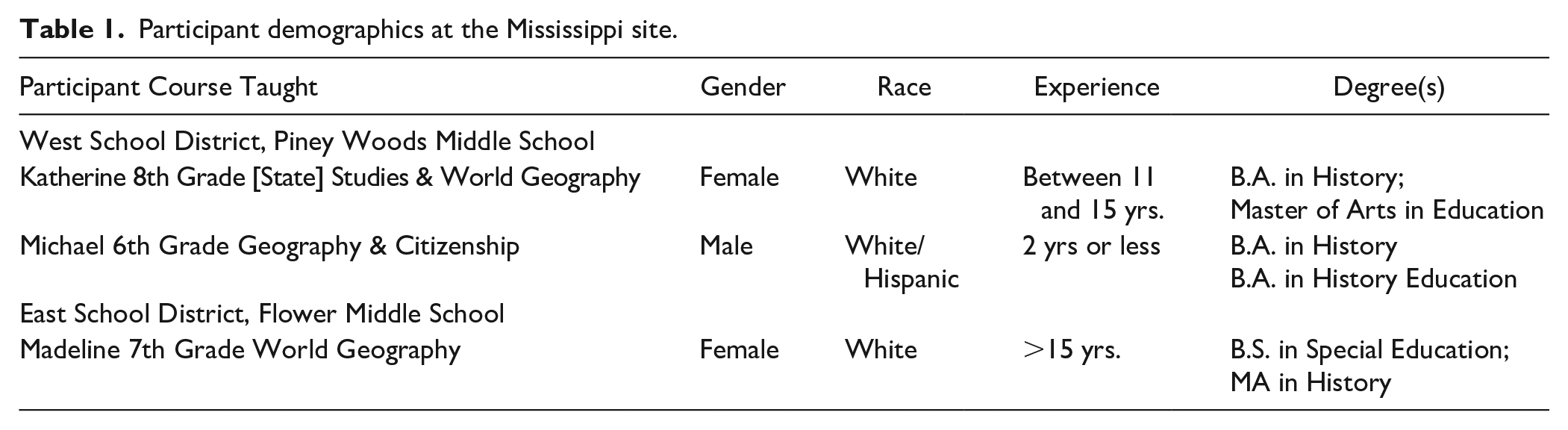
In 2016, the first year of the project, Piney Woods Middle School had 404 students, 85% of whom were White and 9% were Black (Mississippi Department of Education, 2016). The state ranked Piney Woods Middle a B school. 42% of students were deemed proficient or advanced in English and 60% of students were eligible for free or reduced lunch. Flower Middle School had 625 students, 75% of whom were White, 15% of whom were Black, and 5% of whom were Hispanic. The state ranked Flower Middle School an A school with 62% of students proficient or advanced in English. 60% of students in the school district were eligible for free/reduced lunch.
The selected teachers were participants in a two-year lesson study project designed to facilitate teachers’ use of problem-based geographic inquiry (PBGI). Lesson study is a research and development approach to PD that involves collaboratively designing a focus lesson within a larger unit, implementing the lesson, reflecting on how the lesson impacted student learning, and modifying the lesson to improve learning.
Yearly lesson study cycles began with a summer seminar during which the project geographer provided content overviews, project researchers modeled PBGI learning strategies, and project participants and researchers engaged in instructional design of a PBGI unit. During the academic year, one teacher participant implemented the planned focus lesson from the unit for all other team members to observe and then critique during a debriefing meeting. After making changes to the focus lesson based on the first observation, a second teacher participant implemented the updated lesson for all others to observe and critique. Figure 1 depicts the yearly lesson study process (Kohlmeier et al., 2020).
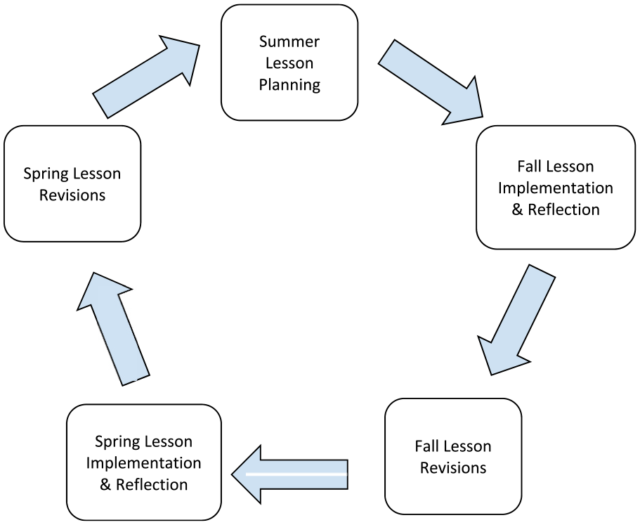
Yearly lesson study cycle.
Teacher participants selected U.S. involvement in global trade as the topic for their two years of work in the project. Global trade was featured in the state standards, the national standards for geography (Heffron & Downs, 2012), and the curricular suggestions contained within the C3 Framework, which asked teachers to help students understand global interconnections (NCSS, 2013, p. 44). Global trade and interconnectedness was also a noted area of concern for the teachers as they considered student learning goals across their geography classes. The teachers wanted to expose students to geographic perspectives beyond those informed by their small town locations. Table 2 below summarizes the unit sequence designed during lesson study. In Year 1, lesson three was the focus for participant and researcher observations. In year 2, lesson five was the focus. As researchers, we acted as instructional coaches, scaffolding the design of the curriculum and the post-observation debriefing conversations. We drew from extensive experience conducting PD with social studies teachers, including several multiyear lesson study projects. We also relied on our personal work in geography. The first author had taught high school geography for several years and had experience framing geography instruction around problems students found interesting. The second author developed expertise applying geographic skills and engaging in spatial reasoning while in the U.S. Army as an Air Defense Artillery officer.
Unit overview.
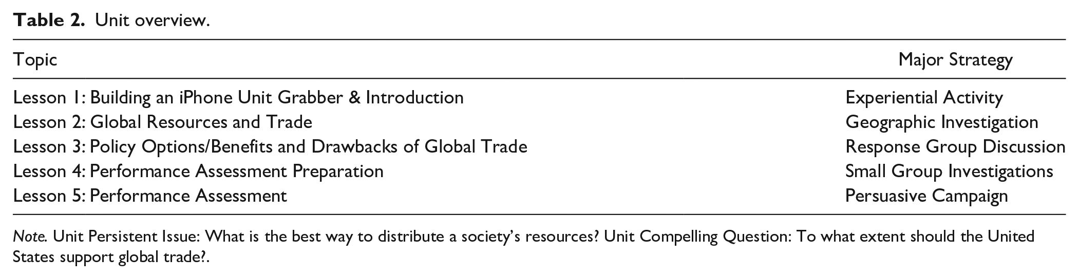
Note. Unit Persistent Issue: What is the best way to distribute a society’s resources? Unit Compelling Question: To what extent should the United States support global trade?.
Methodology
We used case study methodology (Yin, 1994) because it allowed us to examine each teacher’s implementation of the designed curriculum and to treat the teacher as the unit of analysis. We organized our data into three cases. Since we purposefully selected the three teachers to highlight the varying ways participating teachers used their geographic knowledge within a problem-based framework for instruction, each case represented an instrumental case study (Stake, 1995). In choosing case study methodology, we were guided by similar case study analyses in political science (see, for instance, Journell et al., 2015) and economics (see, for instance, Ayers, 2019).
Each case consisted of data collected across two years of the project: ten days of curriculum planning across two summers, focus lesson implementation observations in Year 1 and Year 2, respectively, and an exit interview conducted at the end of the project. Appendix C summarizes our data collection efforts for the first (AY 2016-2017) and second (AY 2017-2018) years of the project.
Participants were initially recruited in spring 2016 and final exit interviews were conducted in spring 2018.
With data organized, we then employed content analysis and analytic induction techniques (Lecompte & Schensul, 1999) to ho-listically conduct within-case analysis and identify emergent themes. We initially coded the data using the geographic practices (Bednarz, 2016) and cornerstones (Gersmehl, 2014) before subsequently coding for instances when both were connected to citizenship. Once fully analyzed, we met to discuss interpretations of each case and to refine our interpretations. When we were comfortable with our interpretation of each case, we independently compared cases before meeting again to discuss holistic interpretations and the lessons learned from all cases (Lincoln & Guba, 1985). Appendix D summarizes our coding scheme.
Findings
In the following section, our findings are organized to address Research Question 1: To what extent did project teachers implement instruction consistent with the problem-based geographic inquiry (PBGI) model? In the subsequent discussion section, we synthesize findings regarding project teachers’ instruction before turning fully to Research Question 2 addressing what social studies teacher educators and professional developers might do to better help teachers engage in PBGI.
Kattherine (veteran 8th grade World Geography teacher)
Planning
Katherine, a veteran teacher, taught several periods of 8th grade World Geography. At the start of the project, it was her second year teaching geography. Katherine had no college coursework in geography and had not participated in any geography-specific PD. In her entry survey, Katherine said she loved activities and projects because “the more students are invested in the learning process, the more they will take away from the lesson.” Katherine also suggested early in the project that she wanted her students to move beyond memorizing geographic material saying students “memorize for a test. . . but have no clue when asked at a later date.”
When goals for the unit were first discussed during Year 1 planning, Katherine noted how her students’ typical response to anything out of the ordinary was “that’s stupid.” Although she did not use the language of a geographer explicitly, Katherine suggested that her students had limited understanding of human conditions which made it difficult for them to ask and answer geographic questions requiring use of knowledge of places beyond the local. Katherine also said she was unsure how to best extend students’ understanding of condition. She described how her students could not conceptualize human trafficking as a social problem that must be addressed with geography because students were unwilling to consider conditions and connections beyond what they already knew. She suggested that students have an “Oh well, that’s not here” attitude and that “getting them to understand that [just because] you don’t think of it as happening in our location, it doesn’ t mean that it isn’ t happening here.” According to Katherine, students could not conceptualize “where things are” in the world much less how human trafficking was a spatial problem at multiple scales. Later, as the teachers worked collaboratively to design the Year 1 focus lesson, Katherine expressed satisfaction that the curriculum included global trade case studies that began with local connections (i.e., a local chicken farm that sells internationally) before extending to the global because starting local meant students would begin with locations that were accessible.
Focus lesson implementations
During the Year 1 focus lesson implementation, Katherine did not emphasize how lessons would prepare students to answer geographic questions and design solutions. She did not, for instance, explain how the geographic inquiry lesson related to the case studies lesson or how both would help students decide if the U.S. should support global trade. To do problem-based geographic inquiry well, students need to be reminded frequently of the geographic question they are seeking to address. For Katherine, however, pressures of time seemed to make her shortcut portions of the case study focus lesson that might have encouraged geographic reasoning. As students tried to decide the best trade policy option for a local chicken farmer trying to navigate foreign competition, Katherine used her own knowledge of conditions and location to tell students the policy option a local chicken farmer would favor. To achieve her stated goal of helping students extend beyond the local, she might instead have asked students questions about the chicken farmer’s conditions or his existing trade connections. Katherine also significantly scaled back the debriefing portion of the response group strategy that would have helped students understand how their selected trade policy options might have impacted U.S. involvement in global trade including the connections required to implement a more expansive trade policy.
Throughout the Year 1 focus lesson and as the above example illustrates, Katherine did draw from her own personal understanding of the small town where her school was located. She frequently used unscripted local examples to illustrate the relationship between location, conditions, and connections. Katherine told students how their local community routinely resisted the influence of more global-minded companies like Walmart and Walgreens because town leaders feared these companies would alter local economic connections. Katherine specifically shared how a Walgreens Pharmacy was turned away by town leaders for fear that the store would destroy the local, family-owned drug store. While these localized examples seemed to maintain student interest, Katherine might also have linked them back to the geographic question at the heart of the unit: Should the U.S. support global trade? She might, for instance, have helped students organize geographic information by asking questions that hinted at the ways local leaders’ rejection of Walgreens reflected resistance to globalization. Doing so might have helped students grapple with how their local community was both connected to and distinct from other communities.
During the implementation of the performance assessment preparation lesson in Year 2, Katherine pointed to an upcoming standardized test as the reason for study, not the authenticity of the assessment, telling students, “You have to read and write on your state tests; I know you hate it, but we have to practice.” Katherine might instead have drawn from unit plans to emphasize how students’ prior geographic analysis would help them design and communicate a solution to the problem via a persuasive campaign on U.S. involvement in global trade. Despite this, during her exit interview, Katherine said she appreciated the PD because the overall focus on U.S. involvement in global trade helped prepare her students as economic citizens.
Michael (novice 6th grade geography and civics teacher)
Planning
Michael, a novice teacher in his second year, taught World Geography and Civics to 6th graders during Year 1 of the study but was shifted to 7th grade World History in Year 2. He described how news reports and comedy sketches that poked fun at Americans’ geographic illiteracy motivated him to teach geography well. He wanted his instruction to correct students’ misconceptions about the world. Michael routinely told his students that “Hawaii and Alaska are not close to each other, despite what maps of the United States show” and that “not all Muslims are terrorists and not all Mexicans are drug smuggling job stealers.” Michael may have believed that his students’ limited sense of condition led them to espouse stereotypical views. In the entry survey, Michael wrote that most of his assessments were multiple choice tests that did not challenge students to think deeply. Consequently, geographic inquiry practices like posing geographic questions and helping students to acquire, organize, and analyze geographic information were not part of his normal instruction.
During lesson study planning, Michael continued to argue that his students lacked a global perspective that permitted them to see how location and condition would influence global connections. According to Michael, his students yearned for simple explanations (i. e., goods do not need to be made in other countries if the raw materials for those goods can be found in the U.S.). As an example, he described students’ confusion during a lesson on “The Travels of T-Shirts in the Global Economy” (Rivoli, 2005). Michael specifically wanted his students to understand a cornerstone of geographic thinking: connection. He wanted his students to see how the world was connected economically by tracking cotton from farm to t-shirt. Unfortunately, students struggled to grasp why cotton “isn’t just grown in Texas, spun into cotton, made into a t-shirt, dyed, and printed to be sold right here.”
According to Michael, instruction grounded in geographic practices like those required for PBGI were important. Since students are “not used to this sort of problem solving” in geography, Michael wanted students to get some practice through the designed unit. During planning, Michael proved capable of using geography content knowledge to push the design team to consider important economic geography concepts such as tariff, quota, and embargo. These were economic geography concepts emphasized by the project geographer in his presentation comparing laissez-faire policies and economic protectionism. Michael was also the team member who most emphasized the cornerstone of connection. Michael reminded the lesson study team that organizations like the European Union and World Trade Organization influence connections and that these organizations represent points along a continuum of economic integration.
Perhaps due to his desire to increase the rigor of his instruction and align it more closely with geographic practices, Michael helped the team conceptualize an engaging geographic question for students to consider as well as an end-of-unit performance assessment that would motivate students to answer a geographic question, design a policy solution, and communicate geographic information in the form of a persuasive campaign about U.S. involvement in global trade. Michael also urged the team to find ways for students to consider the spatial patterns that emerged because of global connections. He understood, however, that any inequitable spatial patterns would have to be addressed through policy. As a result, he wanted students to grapple with who benefited most from global trade. When it came time to plan for focus lesson observations, Michael was adamant that the thing that needed to be most observed was whether students understood the benefits and drawbacks of various trade options and how a trade action in one country might impact another country. To Michael, the designed curriculum achieved his aims because it “connect[ed] to a real-world, persistent public problem” and put students in a position of reasoning with geography to make important decisions.
Focus lesson implementations
During the focus lesson implementation in Year 1, Michael was one of two teachers who reminded students of the geographic question posed in the unit. He did so by asking, “What were we trying to figure out?” When a student responded with the geographic question about the extent to which the U.S. should support global trade, he asked, “What does that mean?” A new student jumped into the conversation and explained that the class was trying to figure out “how far the U.S. should go.” While this example illustrates his grasp of the geographic question anchoring instruction, Michael largely abandoned the question during the middle of the lesson and therefore failed to employ other geographic practices. For example, student groups were supposed to present their economic policy choice in response to each of three global trade case studies. Next would have been a whole class deliberation about the proposed policy solution and its impact on U.S. involvement in global trade during which the teacher might ask questions about the case actor’s location, conditions, and ways existing connections could influence the types of global connections the case actor would favor. Michael did not use these cornerstones of geographic inquiry to help students reason with geography, however. Given his stated goal of helping students understand the benefits and drawbacks of various trade options and how those options impact trade patterns, exploring the proposed policy solutions and global trade connections discussed within the case studies would present the best opportunity to achieve those ends. While Michael did question each group’s choices by asking them to explain their favored policy option, more fully integrating core concepts like location, condition, and connection would help students reason geographically about U.S. involvement in global trade.
Despite missing opportunities to question students more fully using the cornerstones of geographic inquiry, Michael did use knowledge taken from the project geographer’s content presentations to help reduce student confusion. At one point, for example, students struggled to think about tariffs accurately. Michael intuitively used a cafeteria metaphor to illustrate how tariffs might work in practice. In another instance, Michael noticed that students were struggling to decide if the primary case actor preferred protectionist, bilateral, or multilateral trade policies. After listening patiently to the group discussion for 2 min, he realized that bilateralism was the source of students’ confusion. Leaning in, he asked, “What two countries would [the case actor] want to increase trade with?” Students responded by digging back into the case and ultimately concluded that the case actor likely preferred protectionist policies that limited global connections. Michael’s actions represented in the moment scaffolding that helped students wrestle with complex patterns of global trade. While the cornerstones of geographic inquiry remained somewhat elusive, Michael pushed students to consider the economic geography concepts he had seemingly mastered. In so doing, he enhanced the students ability to think about the connections required of various trade arrangements.
Madeline (veteran 7th grade geography teacher)
Planning
Madeline, a National Geographic Certified Educator, was the second most experienced teacher on the lesson study team and by far the most experienced with geography. Administrators at her school praised Madeline for her professionalism, high expectations for student learning, and expert classroom management skills. Quoting Marie Montessori in her entry survey, Madeline said, “The greatest sign of success for a teacher is to be able to say, the children are now working as if I did not exist.” Madeline was an avid traveler and regularly attended PD activities each summer, many of which were connected to geography. In talking about her specific goals for geography prior to the start of the project, Madeline emphasized cooperative learning and critical thinking. As an example of how she achieved these goals, she described how one performance assessment required student teams to apply geographic practices. Teams conducted exhaustive research on a geographic problem tied to a region in the world before producing a live National Geographic-style documentary that included the problem’s impact and student-generated solutions. Madeline linked the idea for the project back to National Geographic’s (2018) Geo-Inquiry framework. For Madeline, Geo-Inquiry was about students becoming “global citizens” who could use geography to inform decisions.
During the planning phase of Year 1, Madeline was most responsible for helping the design team narrow the geographic question from globalization to U.S. involvement in global trade. After examining state and national geography standards which emphasized trade, she zeroed in on the core geographic cornerstone of connection and its relationship to condition and location. She wanted students to understand that global trade was not arbitrary but emerged because of “where the resources are” and “who needs what” to produce goods. In the dialogue that follows, Madeline used knowledge of what she called “interdependence” (connection) to steer the lesson study team towards a more precise geographic question.
“What about like with global trade and how it came about—you know, what makes global trade effective? What cooperation techniques are used? Why is Canada our best trading neighbor? Geography, of course! They’ re right next to us! I do a lot of group work in my class, and we talk a lot about cooperative learning, and what makes a good team, but what makes an effective trade partner?”
Ok, so it’s almost like a rationale for making that choice—
Right, and like why is it working? Why does it continue to work? Or maybe stop working.
Madeline, like Michael, wanted students to understand that not everyone benefited from global trade equally, so students needed to wrestle with “the best way to ensure that everyone benefits from globalization.” She wanted students to reason spatially and hoped that the unit would help students understand how local actions impact global patterns and vice versa.
As with the geographic question, Madeline was also a strong proponent of applying geographic practices. Perhaps drawing from her experience using National Geographic’s Geo-Inquiry framework, Madeline argued the unit performance assessment should force students to create and communicate answers to the geographic question posed. As the quote below illustrates, Madeline’s thinking may have stemmed from her worry that students’ location and limited sense of condition limited their ability to answer geographic questions.
We’re in the middle of the Bible belt, and [students] have been grounded in these same thoughts and ideas for generations and everything else is just—they don’ t want to be aware of what else is out there. They want to live in their bubble and ignore what goes on outside of that.
Focus lesson implementations
During the Year 1 focus lesson implementation, Madeline began by not only reviewing the geographic question posed to students but by explaining how understanding the benefits and drawbacks of global trade would help students answer it. Later in the lesson, Madeline also employed a team-designed “Benefits and Drawbacks of Global Trade” scaffold to help students synthesize their findings from the focus lesson prior to completing a sticky note formative assessment that asked students to give their initial thoughts on whether the U.S. should support global trade. Combined with her efforts to review the prior lesson and her reminder to students that they would have to create and communicate an answer to the question during the end of unit performance assessment, Madeline seemed to understand that the team designed lessons existed as part of a larger unit employing geographic practices - namely that students would have to decide a policy question about global trade and support their decision with geographic data. She also understood that students would need assistance both in organizing and analyzing geographic information if they were to answer the geographic question effectively.
In addition to using previously designed “hard” scaffolds (Saye & Brush, 2002), Madeline was also able to provide scaffolding in the moment that pushed students to employ geographic concepts more authentically. For example, she worked the room as student groups completed the case studies and probed students in ways that resulted in higher order thinking with geography content. The students’ understanding of the economic policy options, their use of economic geographic terms like tariff, and their ability to take a defensible position on the case studies were all improved by Madeline’s efforts. The dialogue below illustrates Madeline’s ability to scaffold students’ understanding of key economic geography concepts such that students could subsequently use them as they shared their responses to the case studies. The dialogue also illustrates how the pressures of time and a resulting focus on efficiency likely encouraged Madeline to reduce opportunities for students to reason geographically using the cornerstones of geographic inquiry (location, condition, connection, and spatial reasoning). The case study in question featured Sam, a small, low-cost grocery owner in a nearby town who was struggling to stock his shelves with cheap products his customers would buy.
Three minutes. Looks like you’re almost there.
Me and him (Student 2) had different ideas on this. Raising the quotas - would that be like where they could trade more with each other?
Tell me what quota means.
[reading from notes] A quota is the number of goods and services that can be imported or exported during a particular time period.
Ok, so if I raise the quota, is that going to help Sam [the case actor]?
I think it would.
As this same group presented its policy choices during the whole class response group discussion, Student 1 demonstrated understanding of the key ideas embedded in the policy options and identified policy options that would benefit the case actor.
Ok, good. [Exits group]
Which [policy options] did you put?
The removal of all tariffs between the United States and the nations in South America because he [the case actor] traded with a paper company from Brazil and that would help him. And, the removal of all embargoes against Chinese goods coming into the United States. Like he bought household products from China; that would allow more products to come into the United States. Raising quotas on all agricultural goods from NAFTA members; that would allow more food products to come into the United States also.
I like it. Good job.
As the closing of the dialogue above illustrates, Madeline missed some opportunities to facilitate a rich class wide discussion of the group’s favored policy option by problematizing their choice. Madeline might have also asked questions of groups that helped them consider concepts of location, condition, and connection. For example, she might have asked questions that led students to consider how Sam’s [the case actor] desire for cheap products led him to consider buying from companies with global connections to ensure the cheapest prices possible. Additionally, if students understood economic policy actions available to the case actors from a geographic perspective, they could consider how the options selected for one case study would negatively impact the other case actors or, at a larger scale, how one nation’s trade actions could impact other nations and funnel down to local communities.
During the Year 2 focus lesson implementation, a persuasive campaign on whether the U.S. should support global trade, Madeline framed the task effectively for students by reminding them of the geographic question posed within the unit and everything they had learned to that point. As students worked in groups preparing their campaign, Madeline scaffolded students’ geographic understandings but misconceptions persisted. In one group, for instance, students argued that the U.S. had no choice but to take protectionist policy actions because it protected American lives and because it would help lower the national debt. In another group, students concluded that free trade caused countries to lose money while protectionism saved money. In these groups, students tended to favor protectionism because they assumed that the benefits of free trade were mostly geopolitical, not economic. Groups who favored free trade wrestled with similar misconceptions. One group, for instance, assumed that free trade meant a nation could trade with any nation, but this denies the role of geography and how location, condition, and connection influence trade. Overall, students struggled to understand the complicated spatial patterns that make up global trade networks and instead sought to simplify those trade choices into more binary geopolitical choices.
Although Madeline pointed out during planning sessions that geography influences trade patterns, Madeline’s tendency was to consider whether students offered evidence to support claims. When students offered a plausible reason for whether they believed the U.S. should support global trade, regardless of whether they applied geographic understandings or not, she moved on. Consequently, the complexity of policy options were sometimes reduced; the fact that physical geography, cultural geography, international trade agreements, and resource distribution influence trade were deprioritized. In discussing the results of the performance assessment during the lesson debriefing, however, Madeline recognized both the strengths and weaknesses of the arguments students made within the performance assessment. On the one hand, she was pleased that her students enjoyed the opportunity to make a choice about what the U.S. should do, saying, “When [students] are given a choice, they automatically like it better; I think it’s just trying to convince someone they’ re right and they like doing that.” On the other hand, Madeline suggested that students retained some misconceptions about global trade, saying, “I think the topic is hard; some of the kids, I could tell, they weren’t getting what I wanted them to get.”
Discussion
Our goal was to determine the extent to which project teachers implemented instruction consistent with problem based geographic inquiry (PBGI; Research Question 1) and to identify what could be done to support geography teachers in this type of instruction (Research Question 2). Regarding Research Question 1, we found lesson study to be a powerful professional development (PD) tool for developing PBGI curriculum aligned with geographic practices. In contrast, however, teachers’ instruction was not always consistent with the model or illustrative of rich pedagogical content knowledge (PCK). Regarding Research Question 2, our findings suggest that we must give more attention to developing teachers’ PCK, including their skills marshaling geographic practices and the cornerstones of geographic inquiry during instruction. We also recognize that more must be done to help geography teachers work through the unique challenges they confront within schools as they seek to develop their PCK. In the section that follows, we explore what might be done to better support teachers’ implementation of PBGI.
Encouraging students to think globally
The three teachers featured in this study entered the project with goals of expanding students’ sense of condition, what others more commonly call “place.” They each argued that their students had very limited understanding of the world beyond their immediate location and that to be effective citizens, students had to break free from limiting views put forth by their respective communities. This collective desire to push students to examine locations outside their own community was a motivating factor for engaging in PD featuring geographic inquiry. All three teachers wanted students to be open-minded and empathetic.
To achieve the full promise of helping students to think geographically about global trade, use of the cornerstones of geographic inquiry - location, condition, connections, and spatial thinking - is paramount (Gersmehl, 2014). For students to build empathy for others beyond their current location, they must be exposed to geographic conditions that influence human behavior. Students must also understand that human connections are not arbitrary and that trade, for instance, emerges because of intentional choices. In the case of Michael and Madeline, we saw them use knowledge of economic geography concepts to support student decision making. However, across all three teachers, we saw less strategic use of the cornerstones of geographic thinking.
Our data makes clear that we did not do enough to develop the PCK needed for teachers to help students think globally. Teachers did not consistently think about U.S. involvement in global trade like a geographer might. We do not consider this an oversight or error on the teachers’ part; instead, we view it as an opportunity for professional developers like us to support geography teachers more fully as they “do” geography. Indeed, we missed opportunities to focus teachers’ curriculum design, lesson observations, and debriefings on geographic content and skills because we tended to focus more on the overarching citizenship goals for the project. We needed to have done more to guide teachers towards geographic inquiry by including more substantive information on the cornerstones of geographic inquiry, particularly spatial reasoning. We also needed to model how those cornerstones are central to geographic reasoning about social issues. Gersmehl (2014), for instance, provides a series of very practical spatial thinking questions that we might have used to guide thinking about U.S. involvement in global trade. Questions centered on location, for example, ask: “What is here at this place? How is this place linked to other places?” Questions like these may have helped us guide teachers in considering how geographic scale impacts decisions about U.S. involvement in global grade. During debriefings, we might have focused the teachers’ attention on students’ use of the economic geography concepts within the lesson or the students’ use of the four cornerstones of geographic inquiry (location, condition, connection, and spatial reasoning). Lesson debriefings tended to drift towards issues of engagement, higher order thinking with social studies content, and civic reasoning about the policy question. All are important and worthy of consideration, but for teachers to develop improved PCK, our facilitation work needed to be much more tightly focused on geographic practices and cornerstones of geographic inquiry. In future projects, it will be essential to integrate the project geographer more fully throughout the project, so we do not lose sight of what it means to “do” geography. Due to scheduling issues, our project geographer engaged only in limited content sessions at the start of the project.
Using PBGI strategies to promote geographic thinking for citizenship
PBGI was new to all three teachers. More importantly, the strategies embedded in the focus lessons as part of PBGI - a response group (Teachers Curriculum Institute, 2018) and a persuasive campaign performance assessment - were also new. For teachers to do PBGI well, they must recognize how these strategies fit within the geographic practices and ultimately develop citizenship skills. In other words, PBGI strategies are intentional and designed to accomplish particular aims. The response group lesson gave students practice considering policy options available to nations as they wrestled with global trade. The persuasive campaign performance assessment gave students experience answering a geographic question using geographic data. These strategies serve the purpose of equipping students to make an informed decision on the unit’s overarching geographic question.
For all three teachers, the novelty of the PBGI strategies proved an obstacle. Teachers missed opportunities to use the strategies to develop students’ geographic thinking more fully. In the response group lesson, for instance, Michael did not engage his class in rich conversation about their selected policy options, nor did he use a prepared scaffold that would have assisted students in weighing the benefits and drawbacks of global trade. Both opportunities might have allowed Michael to emphasize geographic practices while also pushing students to justify their policy choices using geographic thinking. Likewise, while Madeline seemed much more assured about the geographic practices, likely from her experience with Geo-Inquiry, she too missed opportunities to employ the strategies to engage students more fully in geographic thinking by asking questions that would encourage students to consider how location, conditions (place), and connections influence global trade.
In addition to understanding PBGI strategies, teachers also needed knowledge of physical geography, economic geography, human geography, civic decision making, and at least some familiarity with leading students to reason ethically. While this complexity reflects the nature of geography itself, we likely asked teachers to do too much too soon. Simply put, they were being asked to wrestle with ways to teach new content using new strategies. Michael, for instance, was eager to use more intellectually challenging instructional strategies. As a new teacher, however, he was still very much exploring what it meant to be a teacher much less a geography teacher. With Madeline, we see a teacher who was predisposed to geographic practices through her engagement with National Geographic’s Geo-Inquiry framework. Yet, even for Madeline, the novelty of the content within the PBGI strategies created challenges. She too missed opportunities to probe students’ geographic thinking more fully in both the response group lesson and the persuasive campaign. These missed opportunities suggest that our goals for project activities needed tighter focus on geographic practices and geographic cornerstones and that teachers needed increased exposure to PBGI strategies.
While there was evidence in other subjects suggesting problem-based learning’s positive impacts on student learning, there was little problem-based, geography education research to inform our perspective on obstacles to PBGI instructional strategies. Our work brings focus to ways that problem-based learning can be accomplished in geography, but we agree with geography education scholars who have called explicitly for “additional [PBL] research concerning best implementation practices and assessment methods” (Bednarz et al., 2013, p. 43). Part of that work must be developing stronger models of geographic teaching and learning that can be employed during PD. In our previous PD work with history teachers, we employed numerous video cases depicting expert teachers using problem-based strategies to help students to think historically. These video cases included teacher reflection about implementation barriers. In our future work, we hope to develop online video cases of geography teachers leading students to think geographically. Since PBGI unfolds over many days, these video cases will be positioned within a larger PBGI unit framework and include linkages to a persistent public issue. This “framing” should help viewers see that similar inquiries could occur with other geography topics or in other social studies disciplines. Combined with genuine teacher and researcher reflection about implementation successes and barriers, these video cases could model the expansion of PCK in an accessible form.
The education and professional development of geography teachers
For geography teachers to effectively expand students’ ability to think geographically and for teachers to have greater comfort using problem-based strategies, changes to teacher education and PD may be needed. All three of the teachers in our project had minimal geography coursework. Madeline overcame this limitation through extensive PD over many years. To decrease the time horizons needed for teachers to develop knowledge of geographic practices and geographic thinking, a geography-specific methods course would be ideal. Recognizing, however, that such a course is very unlikely given pressures on education degree plans, social studies teacher educators could emphasize what it means to “do” geography using both the practices and cornerstones of geography. Since many P-12 students take only one or two geography courses, teacher educators might instead help teacher candidates consider ways to do geographic inquiry within other social studies subject areas. In geography, teacher educators might, for instance, help teacher candidates plan instruction that examines the spatial dimensions of a historic problem or modern social issue. Efforts have been made in economics that might provide appropriate models (see, for instance, Schug et al., 2018). If the cornerstones of geographic thinking could be unpacked within multiple contexts, social studies graduates might have a stronger frame of reference for thinking about what it means to “do” geography. Even one hands-on, community-based geography experience (see, for instance, Hall et al., 2020), tied to a persistent social issue where students apply the cornerstones of geographic inquiry could provide candidates with a model for doing geographic inquiry.
Geography-specific PD that assists teachers in using both the practices and cornerstones of geographic inquiry will remain important. Such efforts, however, may be more challenging than in other social science subjects like history. Along with the limited content training previously noted, geography teachers are less likely to have mentors who engage in rigorous geography instruction. Many middle and high schools only have one or two geography teachers, so assembling a core group of geography teachers interested in implementing geographic inquiry is challenging. In our study, we found ourselves very fortunate to have at least one teacher deeply knowledgeable of Geo-Inquiry. If every school had a teacher like Madeline, we believe geography teachers might require less PD support. Madeline was already convinced that geography mattered in her school and state and that geography had embedded skills that were useful for solving complex problems. We would contend, however, that Madeline is an exception to the norm. As a result, we need more examples of expert geography teaching, including PBGI, that can be emphasized during teacher education and PD to help novice geography teachers develop expertise.
In some instances, the schools where the teachers were employed inadvertently worked against our PD efforts. Michael and two other teachers in the wider project were moved out of geography following Year 1 and were moved into World History or U.S. History. Michael entered the project committed to expanding the rigor of his geography teaching, but doing so was never going to be an instantaneous effort. When Michael was moved to World History following Year 1 of the project, his chances of developing PCK in geography were substantially diminished. When teachers are consistently moved from geography to other social science subjects that commonly receive more attention, it becomes even more difficult to develop expert geography teachers capable of implementing PBGI.
As we have wrestled with how to overcome the obstacles of doing PD with geography teachers, we wonder if smaller scale, PBGI interventions might prove beneficial in developing teacher’s PCK. If we could combine those efforts with a commitment from administrators to focus on enhancing geography teaching, we might be able to create the contexts that would help us develop additional models of expertise. While Madeline, for instance, was the teacher most predisposed to the ideas embedded in PBGI, she was also the teacher who felt most supported by her administrator. Her administrator consistently praised her classroom management as exemplary, but he also recognized the intellectual rigor of her geography teaching and all her efforts to engage in PD to improve it. Indeed, he consistently supported her work with the state geographic alliance and with our own project even as it took her out of the classroom. Given the time needed to develop PCK, it seems important that those engaged in geography PD more fully engage with school and district-level administrators prior to and during their work to ensure the strongest commitment to the work as possible.
Teacher beliefs
The three teachers featured in this paper were compassionate, collaborative, and devoted to their craft. Any limitation imposed by teacher beliefs represents a failure on our part to shift those beliefs. Intentional elements designed to shift teacher beliefs were embedded in our efforts: a focus on “our” lesson (not the teacher’s teaching), modeling of student-centered strategies, carefully scaffolded planning and observation reflection guides, and collaborative conversation after implementations focused on student learning. We acknowledge, however, that participating teachers’ beliefs about students’ ability to do geography may have limited their willingness or ability to implement PBGI. While provincial beliefs about students encouraged teachers to engage in geography-specific PD, those same beliefs may have led teachers to reduce the intellectual burden placed upon them. Combined with pressures of time, the curriculum was sometimes narrowed, teaching shifted towards content mastery, and the need for student deliberation was reduced.
Shifting teacher beliefs (Nespor, 1987) is challenging work (Howell & Saye, 2015). Past experience working with history teachers in one of the poorest counties in the United States suggests that models of vulnerability whereby teachers publicly shift from deficit-based to optimistic beliefs about students can have an impact. In future video cases of geography teachers, we hope to capture teachers not only leading students to think geographically but being vulnerable about what it took to do so. Teacher noticing (Sherin et al., 2011; van Es & Sherin, 2002) using such video cases may be one means to shift teacher beliefs during future PD efforts since the focus of teacher noticing work is on seeing teaching in interactional terms. If, for instance, a PBGI video case captured a teacher lowering the cognitive demand of an instructional experience, we might follow the episode with conversation about why and the role beliefs played (Kisa & Stein, 2015). If we were successful in capturing vulnerability within a geography context, we might use it to create a safe environment where teachers are willing to reflect on how their views of students impact their geography teaching.
Conclusion
Our study illustrates an authentic geographic inquiry project that pursues integrated and complex aims - teachers’ use of geographic practices and geographic inquiry for the overarching purpose of developing students’ ability to address social issues as citizens. It addresses calls from geography education researchers for more classroom-based studies that document how teachers with and without strong backgrounds in geography come to implement high quality instruction (Bednarz et al., 2013). Recognizing that geography is itself complex, our work also addresses calls for research that examines how teachers can facilitate students’ use of multiple subjects, geography and economics in our case, to address complex problems (Bednarz et al., 2013).
As researchers, we have been closely involved in a series of lesson study projects with the same basic objective: to build the capacity of teachers to design and implement problem-based inquiry instruction (Saye & Brush, 2004). Our most recent efforts to engage geography teachers in designing and implementing PBGI have been rewarding and represent our first sustained attempt at addressing calls for additional research investigating exemplary geography teaching. Students need experiences using geographic thinking to address social issues. In this study, we have presented three teachers who collaboratively designed and then implemented PBGI instruction. Given that few of the teachers in our study clearly scaffolded students’ geographic thinking, more must be done to support geography teachers.
We are optimistic about the ways PBGI can assist geography teachers. In our work with history teachers, we found that repeated professional development efforts that emphasized teachers’ use of core disciplinary concepts to address persisting societal questions helped teachers to see coherence within and across their curriculum. As teachers created more problem-based units, they developed a curriculum where civic and historical reasoning skills were repeatedly practiced and deliberation about persistent social issues was commonplace. While we have a long way to go in our work, we look forward to future research efforts to cultivate this same sort of curricular coherence in geography classrooms.
Footnotes
Problem-based Geographic Inquiry.
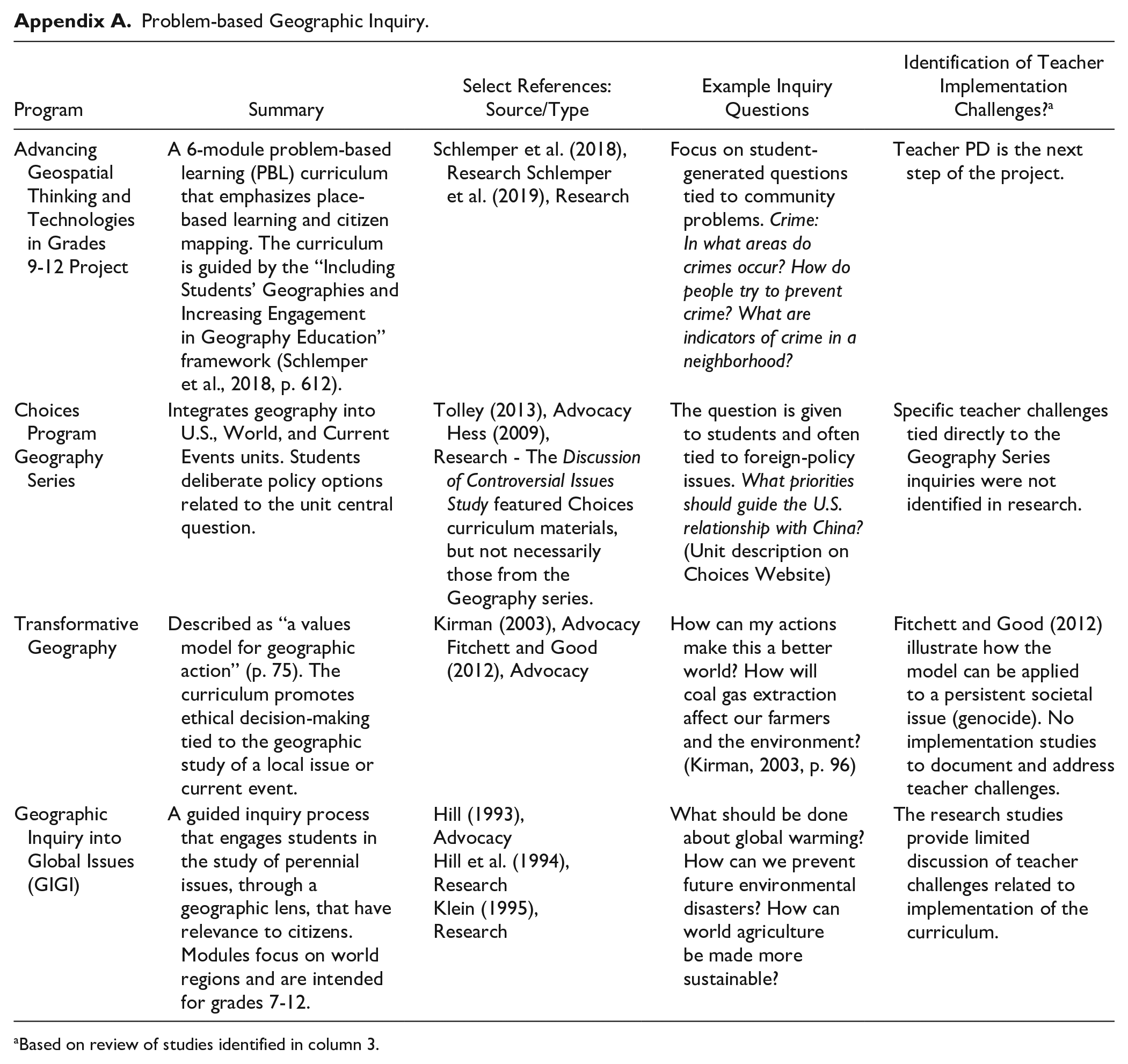
| Program | Summary | Select References: Source/Type | Example Inquiry Questions | Identification of Teacher Implementation Challenges? a |
|---|---|---|---|---|
| Advancing Geospatial Thinking and Technologies in Grades 9-12 Project | A 6-module problem-based learning (PBL) curriculum that emphasizes place-based learning and citizen mapping. The curriculum is guided by the “Including Students’ Geographies and Increasing Engagement in Geography Education” framework (Schlemper et al., 2018, p. 612). | Schlemper et al. (2018), Research Schlemper et al. (2019), Research | Focus on student-generated questions tied to community problems. Crime: In what areas do crimes occur? How do people try to prevent crime? What are indicators of crime in a neighborhood? | Teacher PD is the next step of the project. |
| Choices Program Geography Series |
Integrates geography into U.S., World, and Current Events units. Students deliberate policy options related to the unit central question. | Tolley (2013), Advocacy Hess (2009), Research - The Discussion of Controversial Issues Study featured Choices curriculum materials, but not necessarily those from the Geography series. |
The question is given to students and often tied to foreign-policy issues. What priorities should guide the U.S. relationship with China? (Unit description on Choices Website) | Specific teacher challenges tied directly to the Geography Series inquiries were not identified in research. |
| Transformative Geography | Described as “a values model for geographic action” (p. 75). The curriculum promotes ethical decision-making tied to the geographic study of a local issue or current event. | Kirman (2003), Advocacy Fitchett and Good (2012), Advocacy | How can my actions make this a better world? How will coal gas extraction affect our farmers and the environment? (Kirman, 2003, p. 96) | Fitchett and Good (2012) illustrate how the model can be applied to a persistent societal issue (genocide). No implementation studies to document and address teacher challenges. |
| Geographic Inquiry into Global Issues (GIGI) | A guided inquiry process that engages students in the study of perennial issues, through a geographic lens, that have relevance to citizens. Modules focus on world regions and are intended for grades 7-12. | Hill (1993), Advocacy Hill et al. (1994), Research Klein (1995), Research |
What should be done about global warming? How can we prevent future environmental disasters? How can world agriculture be made more sustainable? | The research studies provide limited discussion of teacher challenges related to implementation of the curriculum. |
Based on review of studies identified in column 3.
Appendix B
Data Sources.
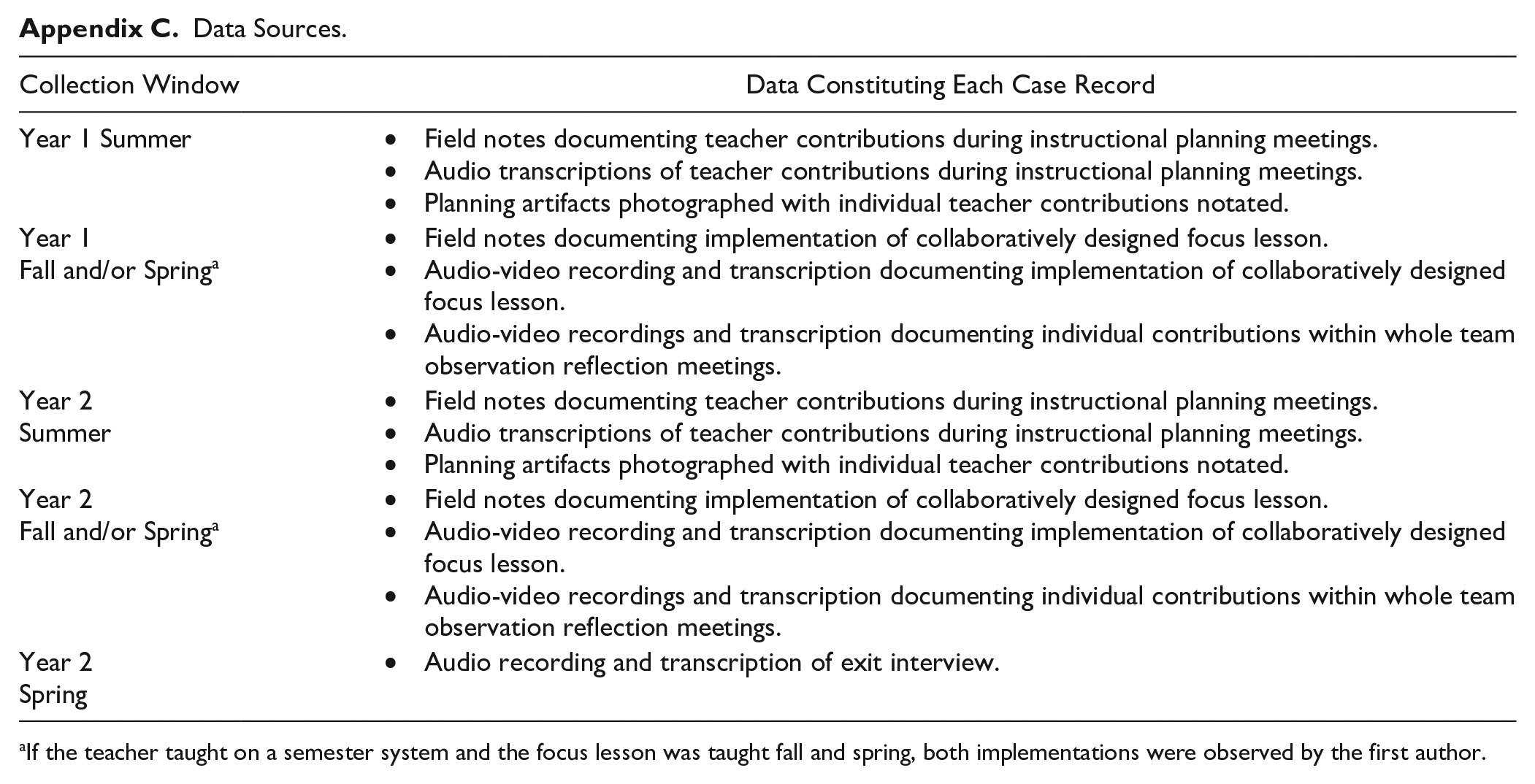
| Collection Window | Data Constituting Each Case Record |
|---|---|
| Year 1 Summer | • Field notes documenting teacher contributions during instructional planning meetings. • Audio transcriptions of teacher contributions during instructional planning meetings. • Planning artifacts photographed with individual teacher contributions notated. |
| Year 1 Fall and/or Spring a |
• Field notes documenting implementation of collaboratively designed focus lesson. • Audio-video recording and transcription documenting implementation of collaboratively designed focus lesson. • Audio-video recordings and transcription documenting individual contributions within whole team observation reflection meetings. |
| Year 2 Summer |
• Field notes documenting teacher contributions during instructional planning meetings. • Audio transcriptions of teacher contributions during instructional planning meetings. • Planning artifacts photographed with individual teacher contributions notated. |
| Year 2 Fall and/or Spring a |
• Field notes documenting implementation of collaboratively designed focus lesson. • Audio-video recording and transcription documenting implementation of collaboratively designed focus lesson. • Audio-video recordings and transcription documenting individual contributions within whole team observation reflection meetings. |
| Year 2 Spring |
• Audio recording and transcription of exit interview. |
If the teacher taught on a semester system and the focus lesson was taught fall and spring, both implementations were observed by the first author.
Coding Scheme.
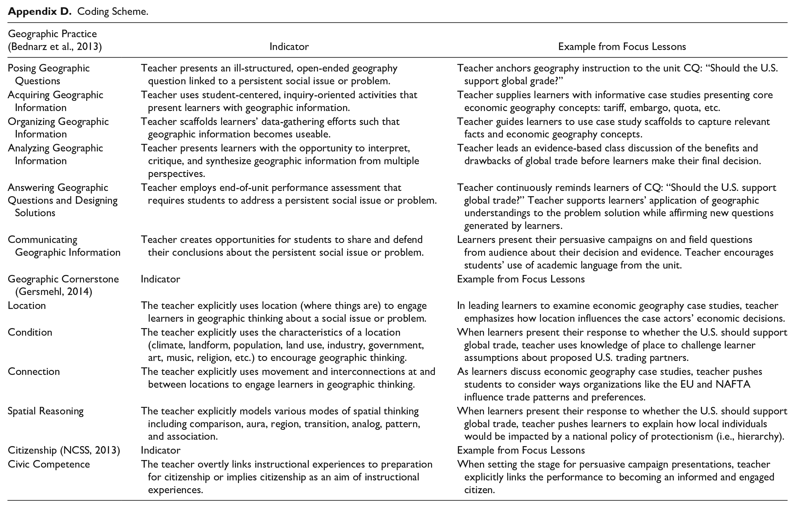
| Geographic Practice (Bednarz et al., 2013) | Indicator | Example from Focus Lessons |
|---|---|---|
| Posing Geographic Questions | Teacher presents an ill-structured, open-ended geography question linked to a persistent social issue or problem. | Teacher anchors geography instruction to the unit CQ: “Should the U.S. support global grade?” |
| Acquiring Geographic Information | Teacher uses student-centered, inquiry-oriented activities that present learners with geographic information. | Teacher supplies learners with informative case studies presenting core economic geography concepts: tariff, embargo, quota, etc. |
| Organizing Geographic Information | Teacher scaffolds learners’ data-gathering efforts such that geographic information becomes useable. | Teacher guides learners to use case study scaffolds to capture relevant facts and economic geography concepts. |
| Analyzing Geographic Information | Teacher presents learners with the opportunity to interpret, critique, and synthesize geographic information from multiple perspectives. | Teacher leads an evidence-based class discussion of the benefits and drawbacks of global trade before learners make their final decision. |
| Answering Geographic Questions and Designing Solutions |
Teacher employs end-of-unit performance assessment that requires students to address a persistent social issue or problem. | Teacher continuously reminds learners of CQ: “Should the U.S. support global trade?” Teacher supports learners’ application of geographic understandings to the problem solution while affirming new questions generated by learners. |
| Communicating Geographic Information | Teacher creates opportunities for students to share and defend their conclusions about the persistent social issue or problem. | Learners present their persuasive campaigns on and field questions from audience about their decision and evidence. Teacher encourages students’ use of academic language from the unit. |
| Geographic Cornerstone (Gersmehl, 2014) | Indicator | Example from Focus Lessons |
| Location | The teacher explicitly uses location (where things are) to engage learners in geographic thinking about a social issue or problem. | In leading learners to examine economic geography case studies, teacher emphasizes how location influences the case actors’ economic decisions. |
| Condition | The teacher explicitly uses the characteristics of a location (climate, landform, population, land use, industry, government, art, music, religion, etc.) to encourage geographic thinking. | When learners present their response to whether the U.S. should support global trade, teacher uses knowledge of place to challenge learner assumptions about proposed U.S. trading partners. |
| Connection | The teacher explicitly uses movement and interconnections at and between locations to engage learners in geographic thinking. | As learners discuss economic geography case studies, teacher pushes students to consider ways organizations like the EU and NAFTA influence trade patterns and preferences. |
| Spatial Reasoning | The teacher explicitly models various modes of spatial thinking including comparison, aura, region, transition, analog, pattern, and association. | When learners present their response to whether the U.S. should support global trade, teacher pushes learners to explain how local individuals would be impacted by a national policy of protectionism (i.e., hierarchy). |
| Citizenship (NCSS, 2013) | Indicator | Example from Focus Lessons |
| Civic Competence | The teacher overtly links instructional experiences to preparation for citizenship or implies citizenship as an aim of instructional experiences. | When setting the stage for persuasive campaign presentations, teacher explicitly links the performance to becoming an informed and engaged citizen. |
Acknowledgements
The authors wish to thank The National Council for Geographic Education for funding this work through the 2015 E. Willard and Ruby S. Miller Grant for Research in Geographic Education. The authors also wish to thank Christopher Cagle and Elizabeth Edwards, graduate assistants at The University of Southern Mississippi, who helped with transcribing data, literature searches, preparing data for analysis, and proofreading and Olivia Brady, graduate assistant at The University of North Alabama, who provided supporting research for the literature review. Finally, the authors wish to thank Dr. Mark Miller, a geographer at The University of Southern Mississippi, who provided content support to the project.