
Abstract
February 6th, 2023 Mw7.7 and Mw7.6 Kahramanmaras earthquakes caused severe damage to lifeline systems across 13 provinces in Turkiye and regions of Northern Syria. Impacts to water and wastewater infrastructure were significant, requiring the mobilization of support from across the region, and around the world to provide life-sustaining service to the approximately 14 million impacted people. This study documents water infrastructure performance during the event and efforts required to repair damage during the days and months that followed. With a particular focus on water transmission and distribution pipelines, details acquired during multiple field reconnaissance visits and meetings with officials are provided for the most heavily impacted water utilities. Both general recovery efforts and specific examples of earthquake-induced pipeline damage are incorporated to draw conclusions relative to emergency preparedness, resilient network design, and communication across agencies as well as with the public.
Introduction
The Kahramanmaras earthquakes of February 6, 2023 consisted of two main shocks. The Pazarcik earthquake struck first with a magnitude Mw7.7 at 4:17 local time with an epicenter in the Pazarcik district of Kahramanmaras Province at a depth of approximately 8.6 km and a total fault rupture of approximately 350 km in length. The Mw7.6 earthquake was the second main shock that struck at 13:24 local time on a nearby fault with a rupture extending about 170 km in length (Turkish Disaster and Emergency Management Presidency (AFAD), 2023a; Garini and Gazetas, 2023). The epicenter was in Ekinozu, Kahramanmaras Province approximately 100 km north of the Pazarcik epicenter, with a depth of approximately 7 km (AFAD, 2023a). These seismic events unfolded along the East Anatolian Fault Zone (EAFZ), recognized as one of the most active fault zones in Turkiye, affecting at least 13 provinces in Turkiye and parts of northern Syria, impacting a population of over 14 million resulting in loss of over 50,000 lives, and significant property damage.
Following the February 6th events, the authors conducted multiple visits to the disaster-stricken area and engaged with relevant utility agencies as members of various reconnaissance teams, including Gebze Technical University and EERI Lifelines teams. This collaboration aimed to offer assistance and gather valuable information regarding the extent of damage and ability to provide water services. Lifeline services in the affected region experienced varying durations of disruption. The extent of damage to these systems was, in many ways, more severe than what has been observed following other recent earthquakes (e.g. O’Rourke et al., 1996, 2014; Toprak et al., 2019; Wham et al., 2017). Permanent ground deformations (PGD), such as fault movement, liquefaction, and landslides, as well as transient ground deformations caused significant damage to infrastructure systems in the region. Following the earthquake, reconnaissance work, reported by Toprak et al. (2024c, 2024d) and GEER-EERI (2023), documented various examples of damage to infrastructure systems. Toprak et al. (2024a, 2024b) also provided an analysis of the performance of water supply pipelines in the affected areas. The disaster area faced substantial disruptions to essential lifeline systems, including water, wastewater, gas, liquid fuels, electricity, communication, and transportation. Unal et al. (2024) reported damage to 21 natural gas pipelines in the region, caused by surface ruptures, landslides, and liquefaction. Uckan et al. (2024) also presented a series of case studies on damage to the Duzbag transmission line caused by the Kahramanmaras earthquake. Based on information gathered from more than 50 interviews during nine visits to the impacted region, this article focuses on evaluating the performance of water systems across various cities within the earthquake-affected zones, as described in the following section.
The disaster area and water systems
After the February 6th Kahramanmaras earthquakes, a state of emergency was declared in the following 11 provinces shown in Figure 1: Kahramanmaras, Gaziantep, Hatay, Kilis, Diyarbakir, Adana, Osmaniye, Sanliurfa, Adiyaman, Malatya, and Elazig, which consisted of an area of 108,745 km2. Shortly after, a state of emergency was declared in the Bingol, Kayseri, Mardin, Tunceli, Batman, and Nigde provinces, an additional area of 53,047 km2, to more effectively provide government support to these provinces (AFAD, 2023b) because they also experienced building damage, especially in towns near the borders with the initial 11 provinces.
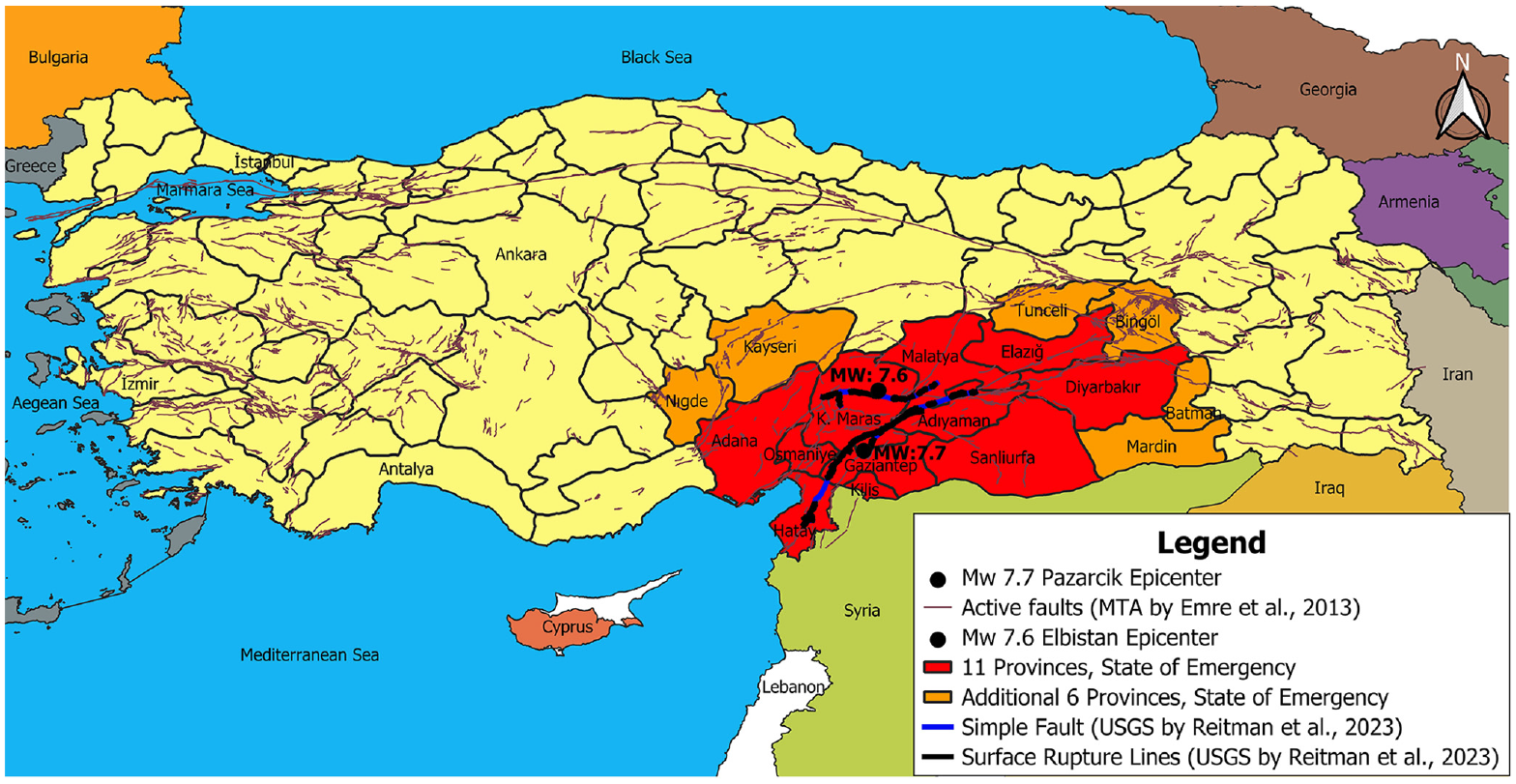
The regions where a state of emergency was declared following the Kahramanmaras earthquakes.
Table 1 identifies characteristics of five of the most heavily impacted water systems within the earthquake-affected zones. Spanning multiple provinces, the damage incurred by these water systems, as well as the responses and recovery efforts undertaken by water utilities in distinct cities, displayed considerable variation in the extent and severity, including building structural damage. In some provinces and towns, rescue operations took precedence and persisted for several weeks, making it nearly impossible to access heavily affected areas for pipeline damage assessments. In Turkiye, provinces having a population exceeding 750,000 can be converted into metropolitan municipalities having boundaries the same as the provincial administrative boundaries. These metropolitan municipalities, identified in Table 1, administrate the water and sewer services for the central city and towns located within the province.
List of water systems studied in this article
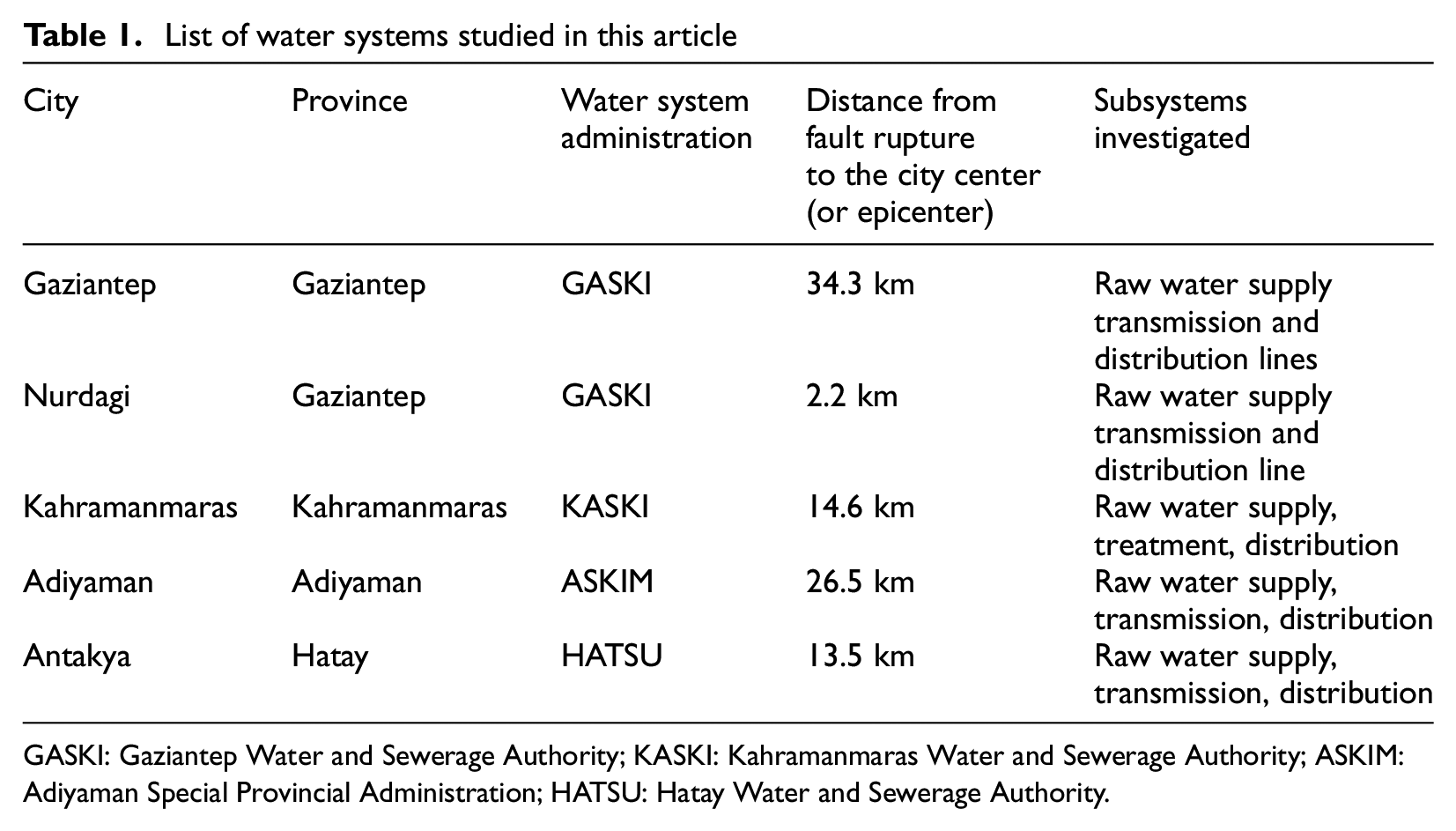
GASKI: Gaziantep Water and Sewerage Authority; KASKI: Kahramanmaras Water and Sewerage Authority; ASKIM: Adiyaman Special Provincial Administration; HATSU: Hatay Water and Sewerage Authority.
The following sections describe the subsystems listed in Table 1 in the order of the cities identified in the first column. Treatment processes were not directly investigated by the authors for this initial effort. Therefore, information on water treatment subsystems is only reported based on general information when obtained in interviews, but more information will be attempted to be described in future efforts.
An initial description of the earthquake impacts to water systems is presented in this article, including a breakdown of the damage sustained and repairs made, the status of services, and insights derived from the earthquakes. Furthermore, corresponding recommendations are offered in the conclusion, grounded in the findings and experiences documented as of the time of this writing. Additional information is continuing to be pursued and, as it becomes available to the authors, will be assembled and reported in future work.
Overview of water systems before the earthquake
Water systems in the disaster area varied among and within the provinces. Also, not all of the water utilities have the same level of documentation about their systems. For example, GASKI was an earlier adopter of geographical information systems and Supervisory Control and Data Acquisition in their operations and as a result has more detailed documentation of their infrastructure than other systems investigated herein.
This study focuses on critical water system components in 4 of the most impacted water administration districts. Table 2 provides a summary of primary attributes of these water administration districts (e.g. water service, infrastructure systems, resources) based on the most recent information available prior to February 6th. Gaziantep city and province are served by GASKI, the largest administrative district, which gained metropolitan status in 2014 and provides water to nearly double the population of the next largest district in the impacted area. KASKI, incorporated in 2014, is the second largest system and serves approximately 1.18 million people in Kahramanmaras Province. Hatay Province, located to the southwest of the impacted region, is served by HATSU and includes the cities of Antakya, which was of the most impacted locations, and Iskenderun, located along the Mediterranean Sea. While the first 3 are provincial districts, ASKIM is the smallest system and only provides service to the city of Adiyaman.
Detailed information about the water administration district service area and infrastructure system
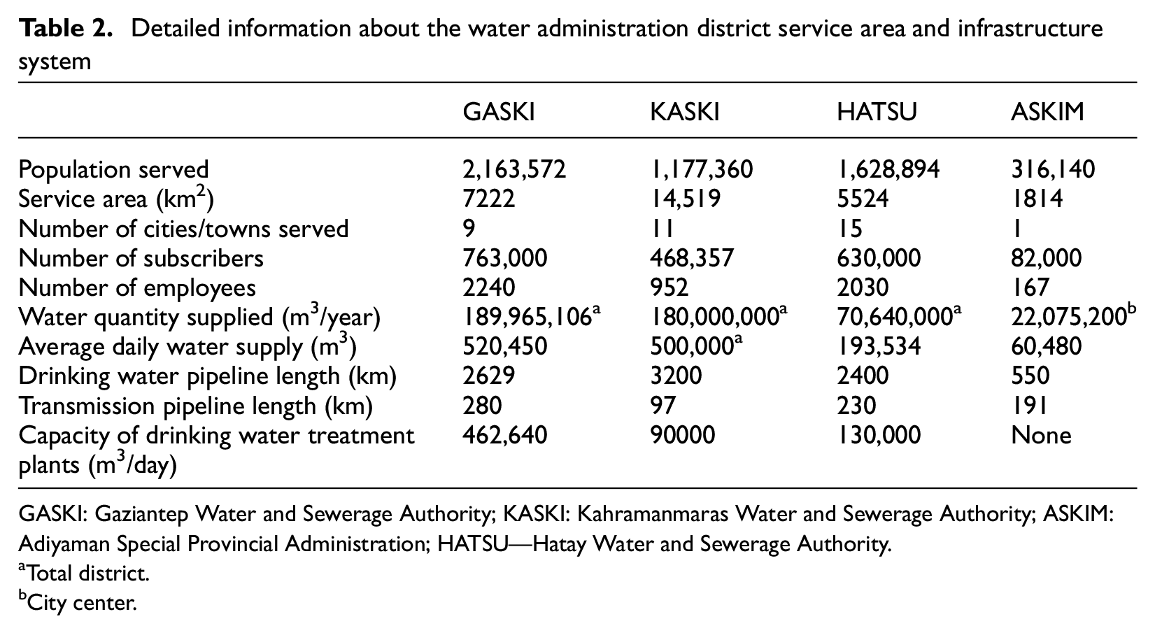
GASKI: Gaziantep Water and Sewerage Authority; KASKI: Kahramanmaras Water and Sewerage Authority; ASKIM: Adiyaman Special Provincial Administration; HATSU—Hatay Water and Sewerage Authority.
Total district.
City center.
Figure 2 shows the coverage area of these 4 water works and sewage administrative districts covered in this study. The “surface rupture lines” in Figure 2 represent the comprehensive mapping of fault surface ruptures seen in WorldView 1, 2, and 3 (2023 Maxar). This classification excludes surface deformations that are assumed to be caused by lateral spreading, liquefaction, or landslides. The “simple fault” label indicates fault traces found using InSAR scenes (Reitman et al., 2023). The active fault in Turkiye can also be seen with brown color in this figure (Emre et al., 2013). The remainder of this article describes how the Kahramanmaras earthquakes impacted the infrastructure in water systems managed by the 4 administrative districts.
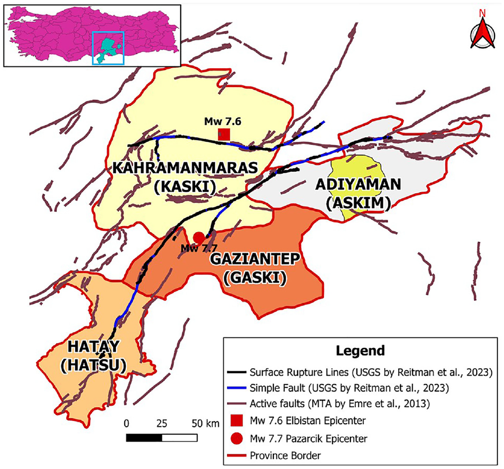
The service areas of HATSU, GASKI, KASKI, and ASKIM.
Gaziantep water systems and damages
Significant damage to the water supply, namely water transmission lines, occurred in this province, as well as water quality concerns in some areas. The process of resolving the water supply issues occurred over the course of several weeks and, after 1 month of efforts, the system was returned to serviceable operations (i.e. adequate volume, pressure, storage, and treatment for consumption). Drinking water-related issues in Gaziantep were primarily resolved by GASKI’s own staff and resources; external utility support was directed predominantly to other regions, including Kahramanmaras and Hatay, where the need was greater. Recovery was also impacted by the significant influx of people to Gaziantep Province from other impacted areas, which resulted in an increasing and irregular demand for water in the region after the earthquake.
Due to the absence of sufficient local water supply, Gaziantep city meets its population’s water needs from three primary sources: Duzbag, Kartalkaya, and Mizmilli. Figure 3 shows that these three transmission conduits transport water from areas to the north and northwest of the city, outside of the provincial boundaries, south and east to the city, and surrounding population. The figure also shows that, while Gaziantep city was located some distance from significant ground movements (e.g. fault rupture), each of its water supply corridors crossed various observed and historically identified offset zones.
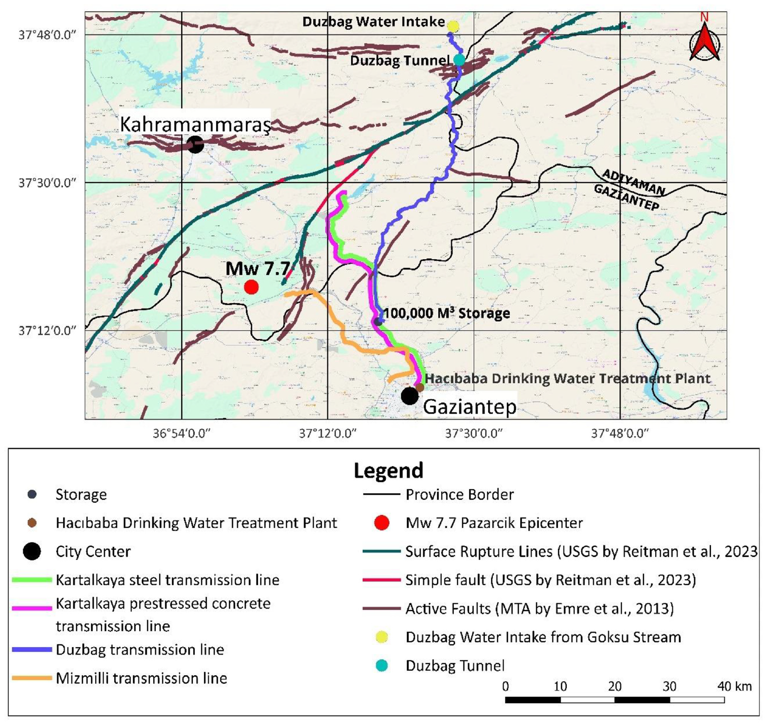
Location of Gaziantep water infrastructure and transmission lines relative to earthquake impacts including surface rupture lines (satellite imagery measured after earthquake), simple faults (INSAR satellite data), and active faults.
After the earthquake, Gaziantep city was without water due to impacts on a variety of critical infrastructure, including water intake structures, energy transmission lines, and water transmission lines. On February 8th, repairs at the Kartalkaya booster station were completed, and water supply to the city was gradually restored. The Mizmilli water source was also put into operation on the same day, but only for non-potable uses due to quality issues (i.e. discoloration, turbidity) and, starting February 21st, its supply was determined suitable for consumption. By March 5th, 27 days after the main events, the water supply was fully restored to the city. Between February 6th and April 24th, GASKI received at total of 80,560 requests from customers for issues related to the drinking water and sewerage systems, including 18,847 in Gaziantep city, 24,541 in Islahiye, 23,035 in Nurdagi, and 7591 in Araban, Yavuzeli, Nizip, and Karkamis towns (Gaziantep Water and Sewerage Authority (GASKI), 2023a). Despite many challenges, including those related to alignment terrain, weather, staff, and materials, the GASKI team carried out rapid repairs and efficiently returned the drinking water system to operation after the earthquake. Solemny, 8 GASKI employees lost their lives due to the earthquake.
Duzbag transmission system
The Duzbag water supply project is the second largest water intake project in Turkiye, after only the Istanbul Melen project. Its design was based on the projected 2050 water needs of Gaziantep Province (GASKI, 2023b). The Duzbag project consists of the Duzbag regulator with intake structures and settling basins (Figure 4a), a booster station, a loading pool, the Duzbag transmission line, the Duzbag tunnel, and connecting lines between storage facilities. The energy required for the booster station is provided from Golbasi district through 23 km of 34.5 kV transmission lines. Water is transferred from the regulator (at elevation 922 m) to the 6750 m3 loading pool (at elevation 1046 m) via four pumps (one extra for backup; Figure 4b). The Duzbag regulator is located north of the Helete (Duzbag) district in Caglayancerit, Kahramanmaras Province, situated on the Goksu River, a tributary of the Euphrates, upstream of the Cetintepe Dam. Duzbag is 117 km from Kahramanmaras city, 22 km from Golbasi, and 17 km from the Caglayancerit district. A series of parallel pipelines with diameters of 1.2–1.8 m orient water from the loading pool to the primary 2.6 m transmission line. The 2.6-m diameter steel pipe, with a wall thickness of 14 mm (0.55″), extends from this source a distance of approximately 82 km to the water treatment center in the city, 3.52 km of which is located within a tunnel. The transmission line crosses through Caglayancerit and Pazarcik in Kahramanmaras Province, Golbasi in Adiyaman Province, and Sehitkamil in Gaziantep Province, finally terminating in Gaziantep city. There are 15 pipeline valves, 44 discharge valves, and 55 air valves along the transmission pipeline.
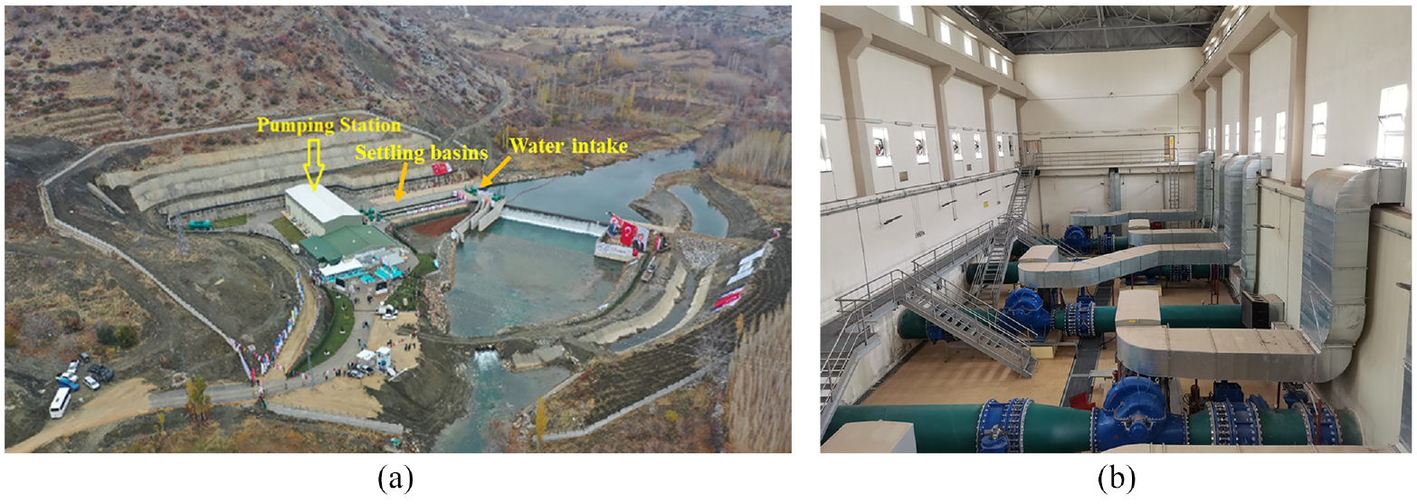
Duzbag. (a) Water intake structures. (b) Pumping station building.
The tunnel, primarily built to house the 2.6-m water transmission line, was constructed in 2019 and includes distinctive engineering features designed to accommodate this crucial infrastructure. The tunnel passes through a fault zone, described later in this section, and was designed to be larger than the pipeline to facilitate maintenance access and protect the pipeline from potential earthquake-induced permanent ground movement during its service life. As shown in Figure 5a, the tunnel’s structural design comprises an inverted U-section with a circular arch, optimizing the tunnel’s integrity and facilitating the management of pipeline conveyance, internal ventilation, and structural loads. The standard internal cross-section width is 5.0 m, ensuring ample space for the enclosed water pipeline and maintenance access. At strategic locations, referred to as encounter pockets, the width is expanded to 8.0 m to provide additional space for operational activities (Figure 5b). The tunnel maintains a maximum height of 5.0 m along its 3.52 km length, allowing for the efficient operation and inspection of the water transmission line. It also features a minimal slope of 0.002, a deliberate design choice to aid in drainage of both water conveyed in the pipe and potential ground water ingresses through the tunnel liner. This tunnel, and the critical water conduit it encases, is an example of advanced infrastructure engineering and modern design practices.
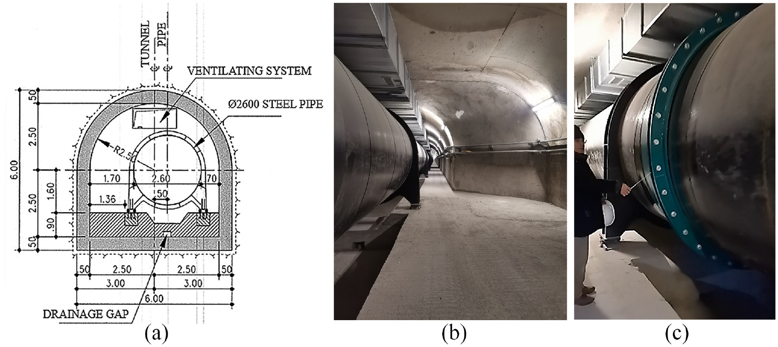
Details of Duzbag tunnel. (a) Cross-section (dimensions in meter). (b) Photo inside of tunnel at an enlarged encounter pocket. (c) Image of pipeline expansion joints and supports (looking north).
The entirety of the tunnel traverses through sediments deposited in shallow neritic facies, manifesting a stratigraphic layering that reveals distinct geological features. The top sections of the tunnel cross-section are embedded in material characterized by light cream-colored, clayey, chalky limestone that occasionally contains chert nodules. In contrast, the lower sections comprise a yellowish, massive, dolomitic limestone with intermittent occurrences of chert nodules, all part of the Midyat formation (GASKI, 2016). The tunnel is situated above the water table along its alignment.
This geological setting is particularly noteworthy due to its proximity to the East Anatolian Fault, which has imparted the area with a highly fractured and jointed structure, occasionally punctuated by crush zones. Such structural complexities are indicative of the region’s dynamic tectonic history, contributing to the diverse geomorphological features observed today. Geologic investigations revealed the presence of a local fault zone related to the East Anatolian Fault, which is shown in Figure 3. Further reporting on the geologic materials that the tunnel passes through is beyond the scope of this article, but is discussed by Ilaf (2019) and anticipated to be described in future reporting of the tunnel performance.
Duzbag transmission pipe is constructed of ST44 steel which is a medium-grade structural steel used for a wide range of applications. This steel grade has a tensile strength of 430–580 MPa, a yield strength of 275 MPa, and an ultimate strain capacity of 23%. With a density of 7.85 g/cm3, ST44 steel is commonly employed in applications such as pipelines, bridges, building structures, and components of vehicles and machinery. It has a combination of desirable properties, including good weldability, machinability, and high strength. The steel pipe has I-beam column supports, shown in Figure 5, spaced at approximately 12.1 m. The steel supports are placed on rollers allowing up to ±0.13 m of displacement along the axis of the pipe while allowing perpendicular movement. The pipeline in the tunnel also has 16 expansion joints which allow approximately 7 mm of axial displacement. A typical roller support and expansion joint are shown in Figure 5c while seismic performance of these components are discussed later in this section.
In the tunnel design, material specifications were aligned with the standards delineated in TS 500 (Turkish Standards Institute (TSI), 2000). Concrete designated as C25 was employed, characterized by a compressive strength of 25 MPa, tensile strength of 1.8 MPa, and modulus of elasticity of 30,000 MPa. Concurrently, the reinforcing steel used was grade S420a, adhering to TS 500 (TSI, 2000) and TS 708 (TSI, 2010) standards, which stipulates a yield strength of 420 MPa, ultimate tensile strength of 500 MPa, and modulus of elasticity of 200,000 MPa. The circumferential reinforcement bars were number 16 spaced at 20 mm on center and the longitudinal bars were number 12 and spaced at approximately 20 mm on center, ensuring the structural integrity of the tunnel design under various stress conditions.
After the first earthquake, the Duzbag transmission line went out of service. There was no electrical power the first night after the earthquake due to issues at 4 locations along the power transmission lines and the absence of backup generators for the source pumps. Within 4 days after the earthquake, GASKI, AKEDAS (Adiyaman Kahramanmaras Electricity Distribution, Inc.), and TEIAS (Turkish Electricity Transmission Corporation) teams identified and repaired the electric power transmission lines (Figure 6), and the water system began to receive power. Due to adverse weather conditions, recovery efforts were delayed. Since the roads were mostly closed due to snowfall, extra effort was required to clear them while some locations were only accessible by snowmobile (Figure 6a). Six days after the earthquake, damages were detected along the 82-km steel conveyance line, and interventions began on the damaged air release valves and drain valves. Locations of repairs made along the northern section of the 82-km-long Duzbag transmission line are shown in Figure 7, superimposed on the peak ground velocity (PGV) distribution of the first earthquake. A description of the damage type, repair effort, and location-specific PGV for the Duzbag system are summarized in Table 3. Repairs and operations were made at 21 locations along the Duzbag transmission line. Of these, 5 were caused by an air release valve malfunction, and 4 were due to drain valve/room malfunctions. In addition, there were issues with the steel pipe at several points, as noted in Table 3. As for the line valves, there are malfunctions at seven points. The water at the noted locations was drained, and the problematic components were replaced, repaired, or reinforced during the restoration process.
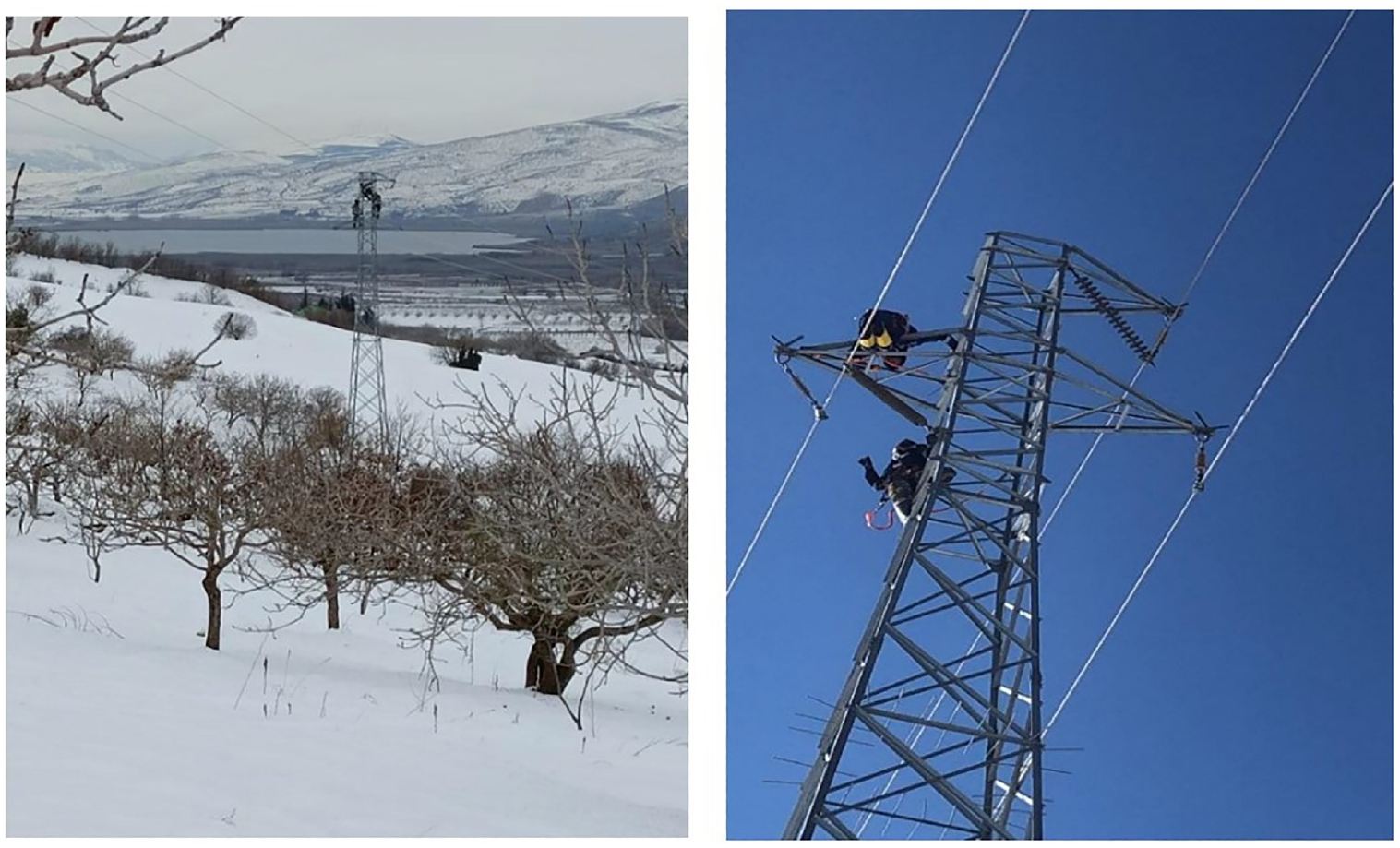
Power transmission line repairs for the Duzbag water sources (Courtesy of GASKI).
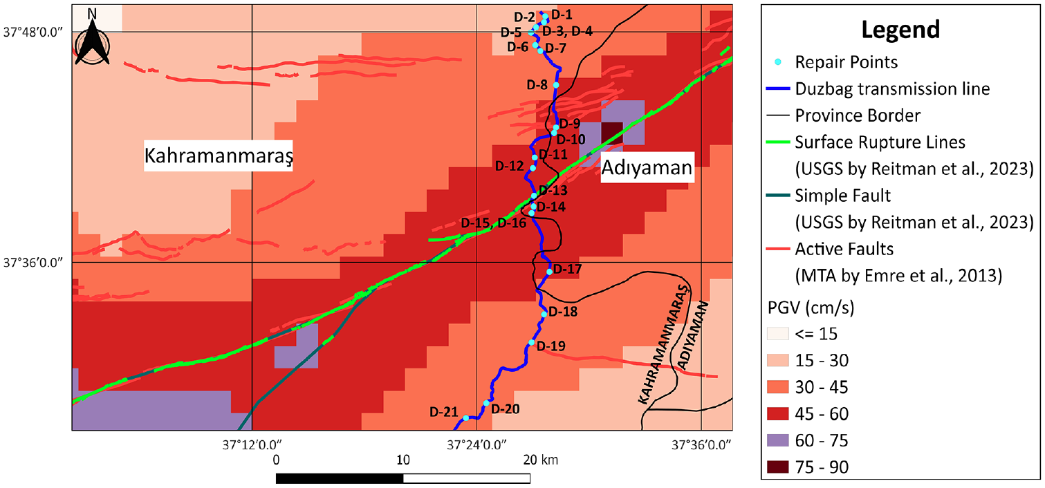
Repair points along the Duzbag water transmission line.
Damages and repair operations in Duzbag collection and transmission system (not including damage to the concrete tunnel liner)
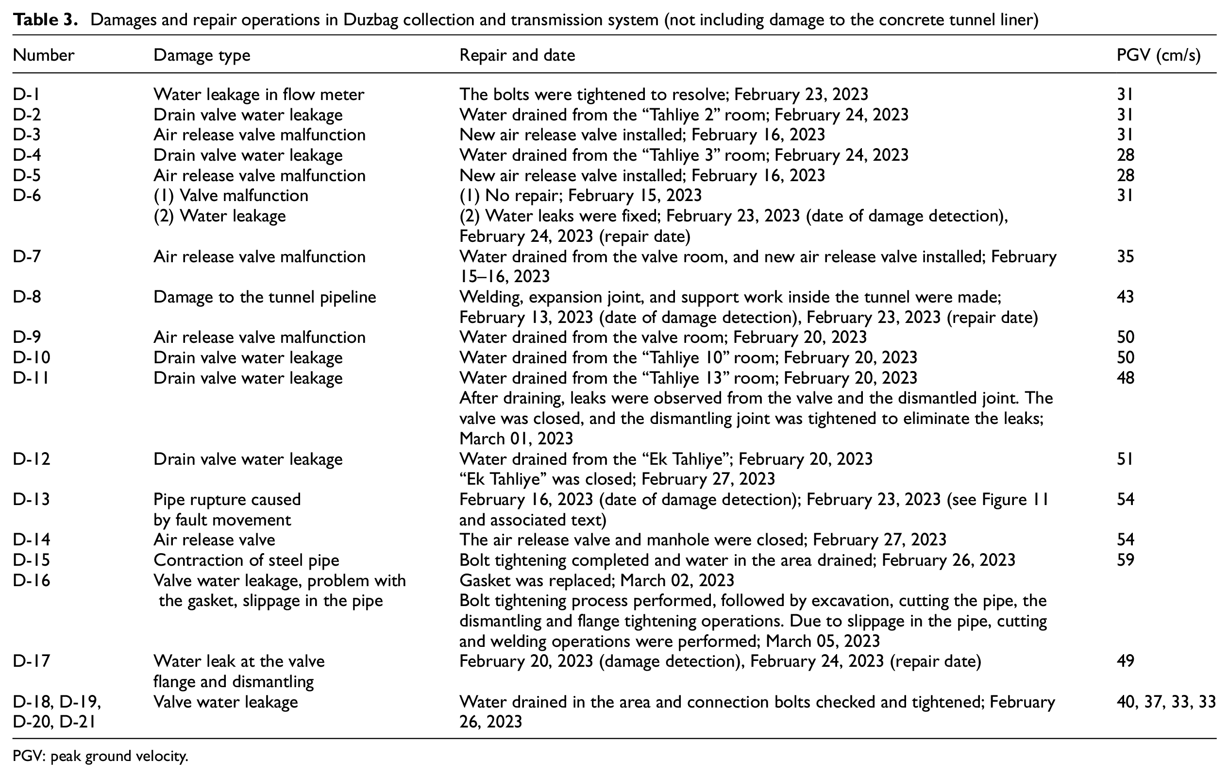
PGV: peak ground velocity.
A week after the earthquake, entry was made into the 3.52-km-long Duzbag tunnel by GASKI and ILBANK personnel to conduct damage detection. ILBANK provides financing for special provincial administrations and municipalities. Nine days after the earthquake, the tunnel and enclosed 2.6-m steel pipeline were rechecked by Gebze Technical University and GASKI teams, followed by two subsequent inspections by the authors in later months. As shown in Figures 8 and 9, the reinforced concrete tunnel was significantly damaged and offset laterally, axially, and vertically, assumed to be from fault rupture, at no less than 7 locations along its alignment. Figure 8 provides geographical information along the tunnel and identifies the approximate locations of seven damages to the tunnel lining, which are reasonably consistent with previously mapped active fault locations (shown as blue lines at the top portion of Figure 8). Given the tunnel geometry and extent of damage, the most consistent location to assess relative movement along the alignment was at the elevated section of the tunnel floor, where distributed horizontal and vertical displacements were recorded with maximums of 15 and 18 cm, respectively. Figure 9 presents measurements of vertical, horizontal, and axial tunnel floor relative offsets at the 7 damage locations.
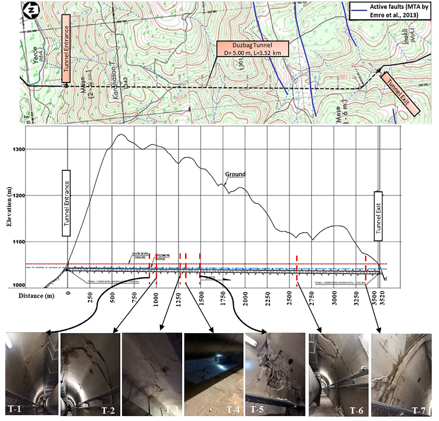
Duzbag water transmission tunnel topographical map of tunnel alignment and active faults; elevation view of tunnel alignment and approximate location of observed tunnel liner damage.
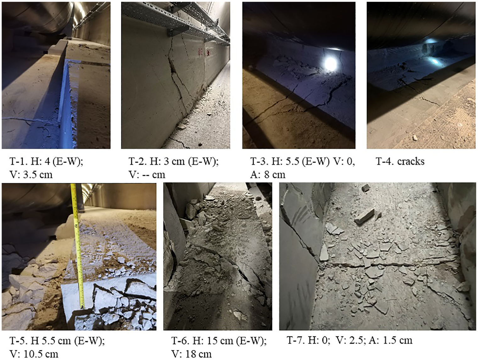
Details of 7 tunnel liner damage locations (T-1 to T-7) including horizontal (H) (all left-lateral direction), vertical (V) (all indicate north side elevated relative to south), and axial (A) (all indicating extension) offsets (all numerical values in centimeter).
These movements also axially displaced the 2.6-m steel pipe at the expansion joints, as shown in Figure 10d, causing damage and/or offset to fixed support mechanisms (Figure 10a) and roller supports (Figure 10c) along the length of the pipeline. To restore the pipe’s support points to near their pre-earthquake positions, a section of the pipe about 10 cm in length was circumferentially cut out, and the pipe was pushed apart from the cut area to both sides using hydraulic jacks (D-8 in Table 3). This resulted in a 30-cm gap at the cut section. A 30-cm-long section of steel pipe was prepared from a spare 2.6-m steel pipe on-site, and it was transported to the location inside the tunnel. At this point, welding and inspections were carried out to complete the repair (Figure 10b). Welding, expansion joint, and manhole work inside the tunnel were completed approximately 3 weeks after the earthquake. There were also several locations where damage (e.g. pounding, localized concrete cracking) at the roller support mechanisms indicated transient movement caused the supports to separate vertically from the concrete base of the tunnel.
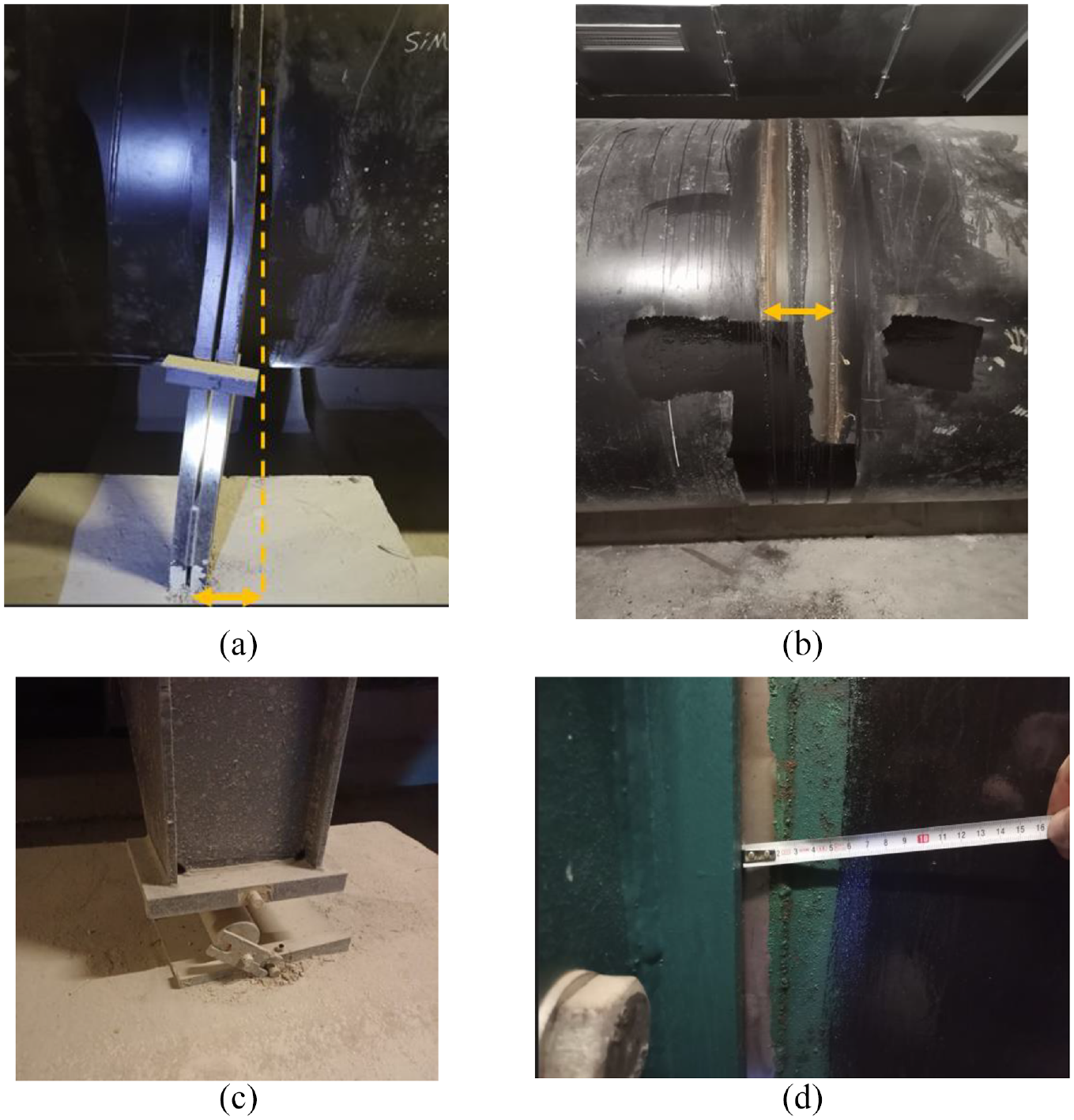
Observations of damage to Duzbag drinking water transmission line and tunnel. (a) Bent fixed support. (b) Insertion of 30-cm pipe segment to reset displaced expansion joints. (c) Damage to the pipe support roller. (d) Axial expansion at pipeline joint.
At D-13, shown in Figure 7 and located between the tunnel and Hacibaba water treatment plant in the city, a sink hole was identified 10 days after the earthquake. Further inspection revealed that a section of the 2.6-m Duzbag transmission line suffered severe damage due to a surface fault rupture. This damage coincidentally occurred where a 1.0-m diameter steel gas pipeline, operated by BOTAS (Petroleum Pipeline Corporation), crosses over the Duzbag pipeline. Figure 11a shows the proximity of the fault line, the 1.0-m gas pipeline, and the 2.6-m Duzbag water transmission pipeline. Also Figure 11a and b provides a closer look at the damage to the Duzbag pipe at the intersection and the approximately 4 m of lateral displacement. There was no problem with BOTAS’s steel gas pipeline. Figure 11c shows the pipes that were removed during the repair process and relocated to a GASKI storage area. The repair process faced significant challenges, including the existence of a water ponding due to the leaking transmission pipeline, the need for extensive excavation, the proximity of the petrol pipeline, and the logistical challenge of fabricating and transporting the large 2.6-m pipelines over long distances. Despite these obstacles, GASKI made every effort to expedite the repair process and restore water to Gaziantep as quickly as possible. Their efforts are illustrated by the notable fact that this location’s entire repair process took approximately 1 week to complete.
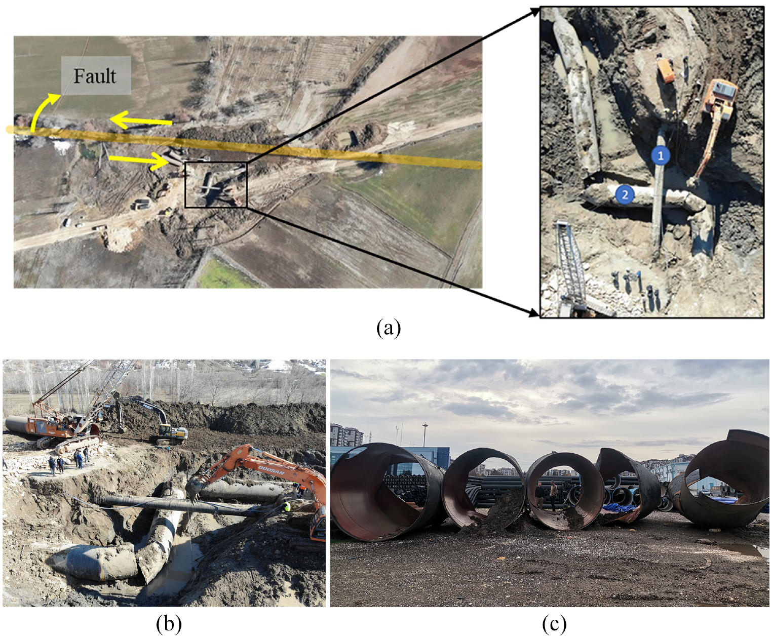
Duzbag transmission line damages at the fault intersection (steel pipe: 2600 mm diameter). (a) The location of the fault line and close up view of the intersection of Duzbag water transmission line (1) and BOTAS gas pipeline (2). (b) The view of BOTAS gas and Duzbag water pipelines intersection. (c) Pipes removed from the ground.
Seventeen days after the earthquake, water was supplied to the Duzbag line, which allowed the detection of previously unknown damage along the pipeline. Subsequently, the necessary water discharges were carried out and repairs completed in the respective areas as noted in Table 3. Air release valves, drain valves, and bolts were checked, and necessary measures were taken for problematic areas (Figure 12). In addition, cathodic protections were inspected, and measurement work was conducted. Approximately 1 month after the earthquake, all identified damages were rectified, and water supply through the line resumed.
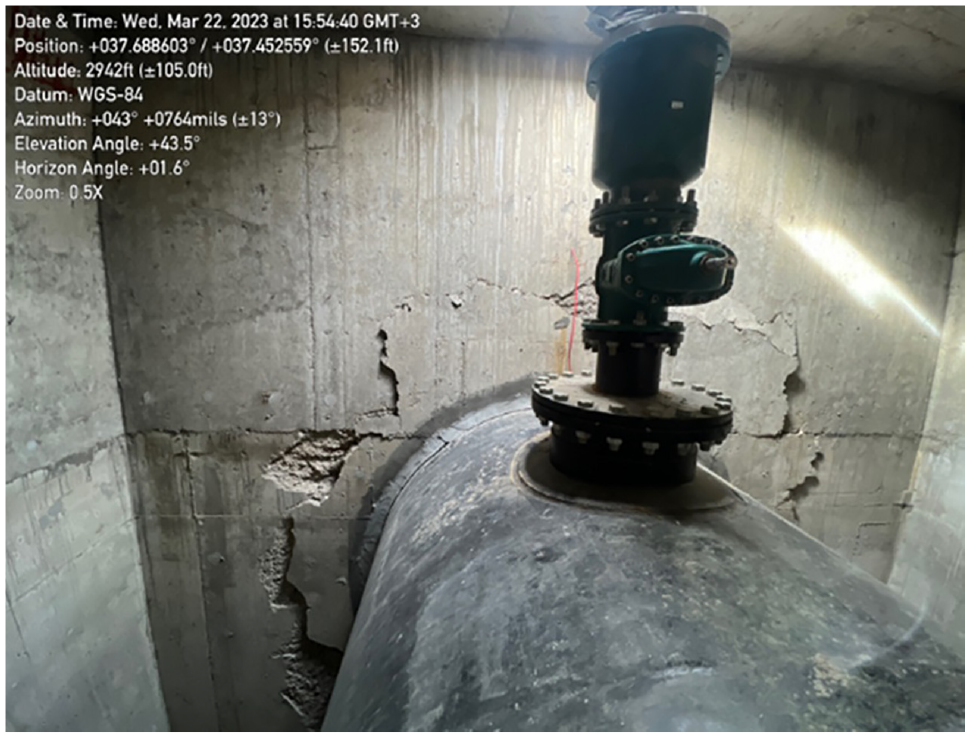
Air valve at crown of pipe in vault with concrete spalding around the entrance point to the vault (between D-11 and D-12).
Kartalkaya system
The Kartalkaya water supply system is 53.7 km long and consists of two parallel transmission lines: the original 1.4-m diameter prestressed concrete (PSC) pipe, commissioned in 1976, and more recently constructed 1.8-m diameter welded steel pipeline, commissioned in 1996 (GASKI, 2023a). While the Kartalkaya steel pipeline supplied 13,000 m3 of water per hour, the reinforced concrete pipeline supplied 7200 m3 per hour. In addition, portions of about 20 km of the Kartalkaya PSC line were replaced with steel at different times before the earthquake. The steel pipeline, which was constructed alongside the older PSC line with approximately 3 to 10 m of separation between them, did not experience any detected damage or leaks due to the earthquake. The Kartalkaya PSC line, however, needed to be repaired no less than 11 times at 6 locations (GASKI, 2023, personal communication). The problems were primarily related to the bell and spigot joints linking each 4-m-long (typical) pipe segment and their gaskets. Figure 13a shows the locations of repairs superimposed on PGVs from the first earthquake. An elevation view of the 6 repair locations along the Kartalkaya PSC line is provided in Figure 13b.
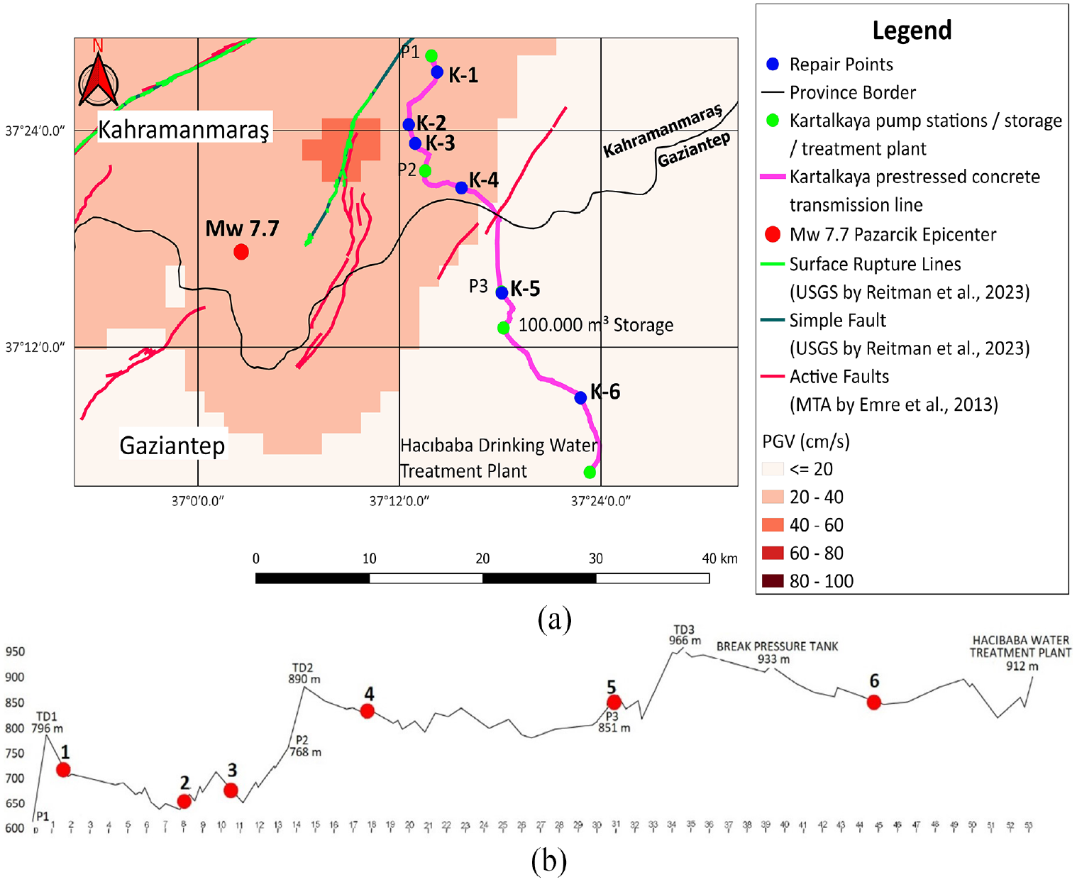
The Kartalkaya prestressed concrete transmission line. (a) Repair locations (K-1 to K-6) and PGV distribution (P1, P2, and P3 are pumping stations; TD1, TD2, and TD3 are collection storages). (b) Elevation view of repair locations.
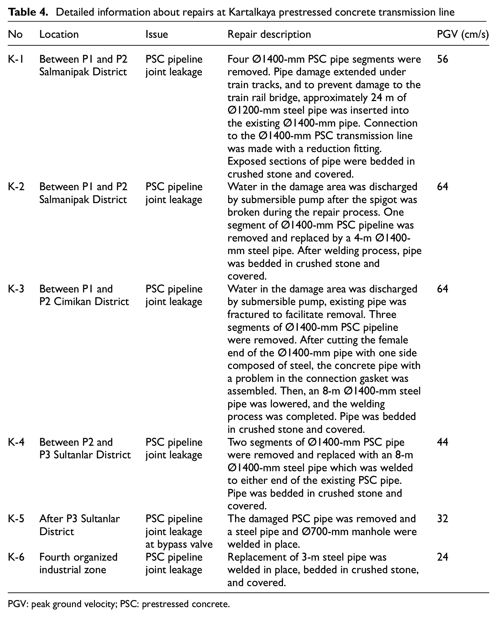
As water was reintroduced into the PSC pipeline after each repair, additional leaks were detected downstream, water was drained from the pipeline, and subsequent repairs made, as detailed in Table 4. Figure 14 shows examples of repair activities at location K-4. As the images show, concrete segments were removed and joints were replaced with steel pipe segments. In addition, all pumping station buildings along the PSC pipeline were constructed from reinforced concrete, whereas the pumping stations for the steel pipeline were prefabricated (lower part reinforced concrete, upper part steel construction). The reinforced concrete structures sustained damage, while the prefabricated structures remained relatively undamaged. Due to earthquake-induced damage to the pipeline and pump stations, the Kartalkaya PSC line has not returned to service as of the time of writing and its future remains uncertain.
Detailed information about repairs at Kartalkaya prestressed concrete transmission line
PGV: peak ground velocity; PSC: prestressed concrete.
Repair activities at location K-4 along 1400-mm Kartalkaya Pipeline (Courtesy of GASKI).
Mizmilli system
Mizmilli transmission line consists of a 42-km-long, 1.2-m diameter steel pipe. Mizmilli is groundwater sourced and water supply is provided from 30 wells with an average depth of 120 m (Figure 15a). Of these 30 wells, 26 are actively operating and the remaining 4 are backup. In addition, 7 extra wells were drilled in Mizmilli before the earthquake to increase capacity, but these wells have not yet been included in the existing 30 well water system due to the earthquake. The groundwater level in each well is 25–30 m below the ground surface. The pumps are at a depth of 60 m in the wells. Water is transported to the TO4 reservoir, with a capacity of about 20,000 m3, via the ground water wells and 3 additional pumping stations at varying elevations. Water then travels to the DY-12 reservoir, with a capacity of 15,000 m3, at the end of the Mizmilli line by gravity. Water is delivered from the submersible pumps in each well to the first pumping station at elevation +588 m. This first stage pumping station lifts the water to the second stage pumping station located at +707 m elevation. The third stage pumping station, TO4, and DY-12 reservoirs are located at elevations +826, +1020, and +983 m, respectively. There are four pumps (one of them is a backup) in each of the pumping stations.
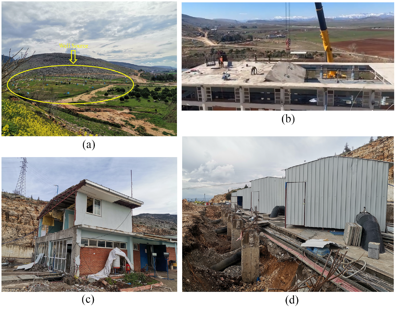
Mizmilli water source and pump station 1. (a) Location of wells at Mizmilli water source. (b) Controlled demolition of pumping station 1. (c) Pumping station 1 control room. (d) Temporary protection pump station 1.
The February 6 Kahramanmaras earthquakes caused damage to the reinforced concrete structure housing the stage 1 pumps. However, the pumps themselves were not damaged. A video recorded within the pumping station at the time the earthquake is provided by Toprak et al., (2024c). Figure 15b and c shows the controlled demolition of the concrete structure, which was carried out to ensure the safe operation of the pumps and to maintain the water supply to Gaziantep city center. The pumps were then placed under temporary protection shown in Figure 15d. Mizmilli started providing water 2–3 days after the earthquake. After the earthquake, well number 8 in the Mizmilli Groundwater Wells Zone malfunctioned. The submersible motor and pump equipment were damaged, but they have since been replaced and commissioned. While there was no other significant well damage detected post-earthquake, the water was cloudy in Mizmilli for at least 1 week following the event. Water from this source was used for cleaning purposes only during this time. As of February 21, adequate treatment levels were achieved and water was deemed suitable for consumption.
Nurdagi district
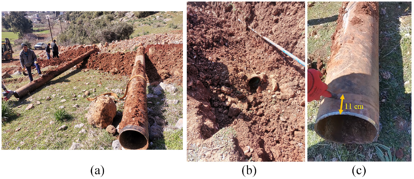
The earthquake caused major structural damage in Nurdagi District town center, located in Gaziantep Province, as well as significant damage to infrastructure systems. There are 88 water wells supplying water to Nurdagi city center as well as 48 water storage tanks. As part of the treatment process, the well water is chlorinated in the tanks and then distributed to the network. The water trunk system predominately consists of 6-m long, 300-mm diameter segmented ductile iron (DI) pipes. During the earthquakes, damages occurred in the DI pipelines due to fault movement and slope displacements. For example, 10 days after the earthquakes ongoing repairs to damaged sections were examined on-site. According to the information received from GASKI staff, all joints along a 300-m section of segmented DI pipeline were separated. Along the damaged line, separations occurred at the 11-cm-long, unrestrained, gasket sealed, bell-and-spigot joints of the segmented pipes (Figure 16). Figure 17 shows the intersection of the fault and the pipeline, as well as the extent of the damage area. Due to the ground movement that imposed mostly axial tension to the pipeline, most pipe repairs required only cleaning the existing pipe joints and reassembling the bell-and-spigot connections.
Ductile iron (unrestrained, bell-and-spigot) pipe damage at Nurdagi area. (a) Removed DI pipe segments. (b) Damaged DI bell. (c) DI spigot.
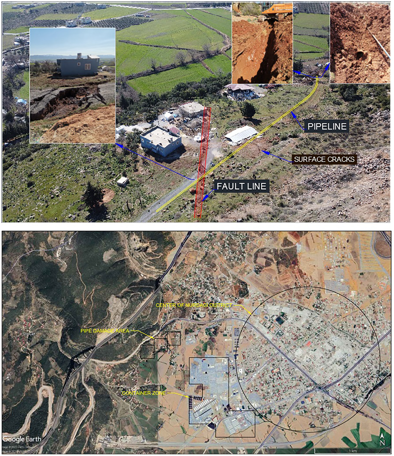
Overview of Nurdagi pipeline damage site.
Kahramanmaras water system and damages
As of the end of 2022 the provincial population of Kahramanmaras was 1.18 million people (Table 2). Kahramanmaras Water and Sewerage Authority (KASKI) was established in 2014 and serves all areas within the 14.52 km2 municipal boundaries.
An investment project funded by the European Union (EU) was approved on January 28, 2019 to meet the demand due to overpopulation (refugee influx due to Syria war) and to prevent water losses in the distribution network, which were around 70%. In the short term, the project planned to replace 85 km of cast iron (CI) pipes in the network. In the medium term, 103 km of asbestos cement (AC) pipes would be replaced. In addition, construction of new and improvements to pumping stations, tanks, and the existing Karasu and Ayvali water transmission lines are planned. On the Karasu transmission lines, construction of two flow measurement rooms and a Buyukgoz flow measurement room, mechanical and electrical modifications of 14 reservoirs and 3 pumping stations, construction of 3 water reservoirs, and renewal of iron and AC pipes (without removal) are planned. As a result of these efforts, the distribution network, tanks, pumping stations, and transmission lines of other network regions within Kahramanmaras city are also planned in the long term (BELGEP, 2022).
At present, the city receives its water supply through the 59.1-km-long Karasu Line originating from the western side of the city. Water is also sourced from the Ayvali Dam, situated on the eastern outskirts of the city, and is conveyed to the Ayvali Water Treatment Plant, located 10 km away, via 1.4-m diameter steel pipes. From there, it is further transported to the city through the Ayvali Transmission Line (ϕ1.5 m), which was completed in 2010. In addition, supplementary supply lines from the northern part of the city facilitate the distribution of water. Finally, water is sourced from the Sanayi, Adana, and Asfalt water supply wells located in the southeastern, southern, and southwestern areas of the city, respectively.
The four primary water sources of Kahramanmaras city center are summarized as (BELGEP, 2022):
Karasu (flow Q = 1.5 m3/s—steel pipeline with a length of 59.1 km and 5.5 km GRP (fiberglass reinforced polyester)),
Pinarbasi (Q = 0.5 m3/s—AC pipeline with a length of 0.85 km),
Ayvali Dam (Q = 1 m3/s—steel pipeline with a length of 27.2 km), and
Groundwater wells (Q = 0.645 m3/s—Steel pipeline with a length of 7.8 km)
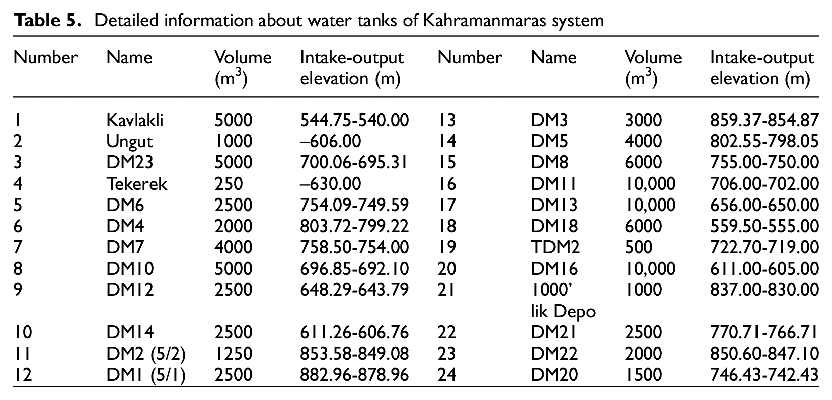
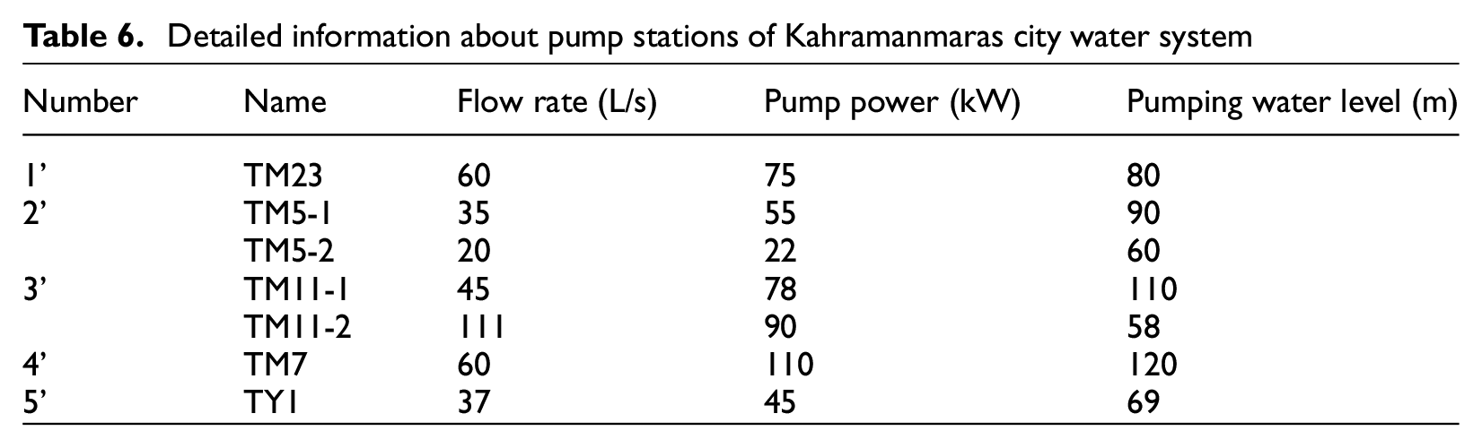
Figure 18 shows water transmission pipelines, water tanks, and pump stations in Kahramanmaras. Table 5 shows detailed information about water tanks of the Kahramanmaras system. The table contains location, volume, intake elevation, and output elevation information for 24 water tanks in the city system. Table 6 shows location, flow rate, pump power, and pumping water level information for the 5 pump stations of Kahramanmaras system.
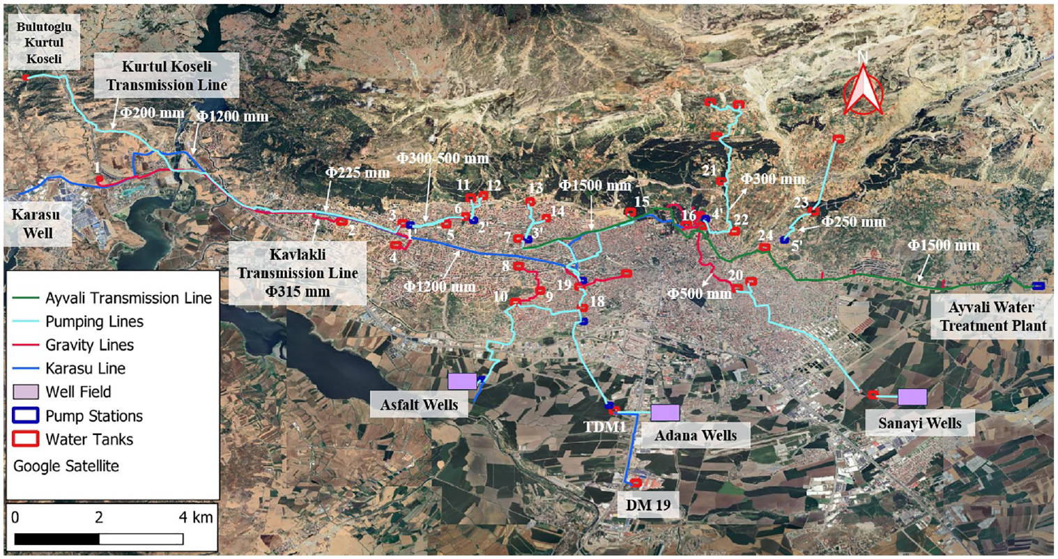
Kahramanmaras water supply system.
Detailed information about water tanks of Kahramanmaras system
Detailed information about pump stations of Kahramanmaras city water system
KASKI manages about 3200 km of distribution network lines in total, including approximately 2500 km in Kahramanmaras city. There are different types and diameters of pipes in the distribution network of the city and their approximate lengths are as follows: polyethylene (PE) (≈2000 km), AC (480 km), polyvinyl chloride (PVC; 480 km), CI (≈85 km), and other.
Following the earthquake, thousands of repair requests and reports of malfunctions were received via calls to the 112 call center. The number of damage calls regarding drinking water and sewage systems for various date ranges taken from the official website of KASKI is given in Table 7. While the last data available before the earthquake was February 03, 2023, the first data shared after the earthquake was April 21, 2023. After the earthquake, KASKI teams perform an average of 100 pipe repairs daily. In addition, structural damage occurred in the standpipe reservoirs within the system. The Ayvali water treatment plant, which is part of the Ayvali Dam source, also sustained damage due to the earthquake but managed to continue operations. Three pressure pipes (125-mm diameter PVC) in the balancing pool were damaged. During the post-earthquake investigation, it was observed that similar diameter PVC pipes with a pressure capacity of 10 bar were being prepared for installation. Details on the number of transmission and distribution pipeline repairs have not yet been able to be obtained from KASKI, but persistent and significant efforts are underway to acquire this information and, if received, will be reported in the future.
The number of damage calls regarding drinking water and sewage systems in Kahramanmaras
Adiyaman water system and damages
Adiyaman’s water supply is derived from various sources, including Gurlevik, Havseri, Tut-Medetsiz, and Koru-Palanli. The water originates from the foothills of the mountains in Adiyaman. Transmission lines extending from these sources serve as the primary means of water supply for Adiyaman (Kacar, 2022). The water pipelines for Havseri, Gurlevik 1, and Gurlevik 2 each span a distance of about 27, 29, and 40 km, respectively. In contrast, the Tut-Medetsiz and Koru-Palanli transmission lines cover distances of about 47 and 13 km, respectively. These transmission lines operate based on gravity flow, and additional details are provided in Table 8. A total of 550 km of urban drinking water distribution pipeline exists in Adiyaman city. These pipelines are constructed primarily of AC, PVC, and PE materials and water is distributed via gravity flow.
Detailed information about Adiyaman water supply system
Years before the 2023 Kahramanmaras earthquakes occurred, plans were made to renovate the aging pipeline systems and reduce water losses in Adiyaman. The Gurlevik Drinking Water Transmission Line Construction Project, which is fully funded through an EU grant and is carried out by the Adiyaman Municipality, under the MADAD (EU Regional Trust Fund) framework, began in April 2021. This project included the construction of a 35-km DI water transmission line and a 20,000-m3 water reservoir. As of August 2022, the construction of six structures, including flow meters and valve chambers, had been completed, and 29 km of the 35-km pipeline had been finished. The project was planned to be fully completed by June 2023 and be functional in the beginning of February 2024. This initiative aimed to prevent water losses due to frequent breakdowns in the Gurlevik Water Transmission Line and ensure longer term water supply in case of potential malfunctions.
In addition, another major project, the Central Drinking Water Network Construction Project, fully funded by the EU under the FRIT-II framework (The Financial Assistance Program for Refugees in Turkiye) and financed by the French Development Agency, was announced for August 2022. This project focused on the renovation of approximately 550 km of drinking water pipelines in Adiyaman city. Furthermore, it involved the construction of a new 10,000-m3 capacity drinking water reservoir. Upon the completion of this project, the city’s internal network would be managed through state-of-the-art automation systems, which was seen as a significant step in promptly addressing potential issues within the drinking water network.
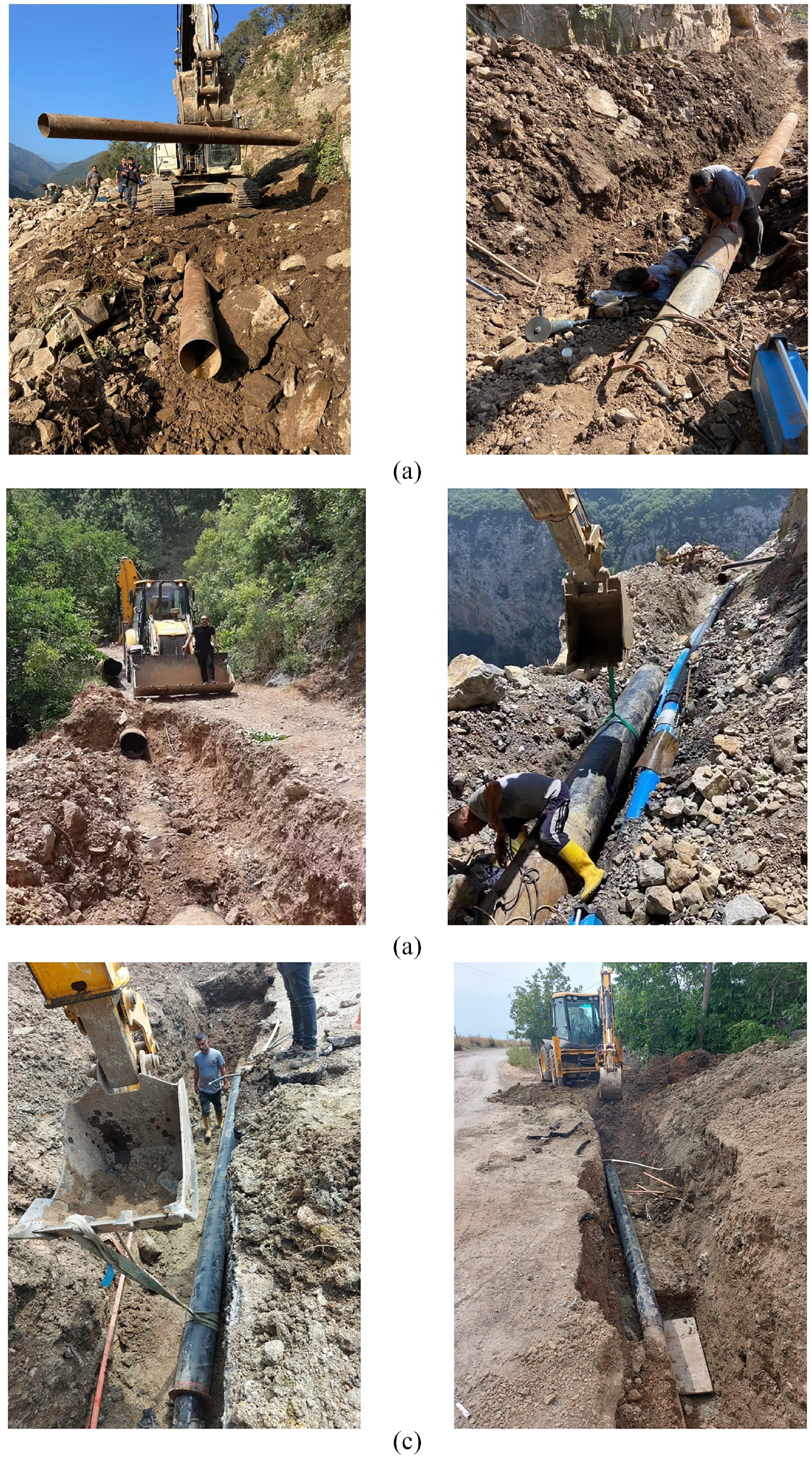
The Kahramanmaras earthquakes caused damage to the water transmission lines. Depending on the territory, PGD, such as landslides and various ground movements, caused damages in the pipelines while rock falls impacted pipelines at other locations. Figure 19 shows some of the damages observed at Havseri and Gurlevik transmission lines. Because some of the water transmission pipelines bringing water to Adiyaman city are old and brittle, many breakdowns occurred in water supply systems due to the earthquake. Examination of the pipeline damage in the aftermath of the earthquake sequence revealed a variety of failure mechanisms, including tensile failures, buckling, bending fractures, and joint failures. Notably, the Gurlevik steel pipeline in Adiyaman suffered significant damage. Some sections of the pipeline were completely separated due to torsional and tensile effects caused by the seismic activity, while other sections experienced transverse (bending) fractures and local buckling due to axial compression forces. These damages were exacerbated by factors such as long-term corrosion in steel pipes, a reduction in wall thickness, and weakened joints (Toprak et al., 2024a). This highlights the critical need for more resilient infrastructure to withstand potential seismic geohazards. To mitigate future risks, measures such as the application of cathodic protection to prevent corrosion, using appropriate lining materials for steel pipes, and replacing pipes that have reached the end of their service life are essential for enhancing the resilience of the water supply system. The new DI pipe located on the Gurlevik transmission line was damaged due to rock falls triggered by the earthquake. The DI pipeline was under construction during these rock falls, and the trench was open during the earthquake. Although repairs were made, since the pipeline was not in service, this damage did not affect the water supply performance. While the Gurlevik 1 and Gurlevik 2 lines were in service before the earthquake, Gurlevik 1 was taken out of service and the DI line was activated afterward. As a result, water began to be supplied to the city center of Adiyaman from both Gurlevik 2 and the DI (Gurlevik DI) line. Thus, the Adiyaman city center was able to take advantage of having multiple water supply systems that could act as alternatives to each other right after the earthquake.
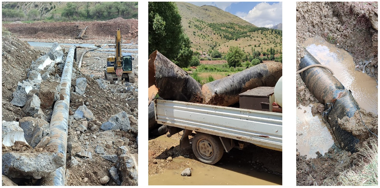
Steel pipeline damages at Havseri and Gurlevik transmission lines (ASKIM, 2023, personal communication).
After the Kahramanmaras earthquakes, the distribution of water within the city was suspended, mostly to ensure the safety of ongoing rescue operations and to protect the lives of individuals trapped beneath the debris of collapsed buildings, especially considering the sub-freezing temperatures. Consequently, the resumption of water supply to the city began on the fourth day, commencing with the Altinsehir district, which had the most recently installed drinking water pipelines within the system. Fortunately, there were only a few issues there, which facilitated the swift restoration of water services. These pipelines were constructed using PE material, resulting in minimal damage.
As water was supplied to the city, the system’s issues became more evident. A substantial number of breaks had occurred, reaching levels that even the dedicated efforts of around 24 Adiyaman Water Works field staff could not handle. To address this situation, water works experts from unaffected provinces volunteered to assist with repair work following the earthquake. Intensive repair work by Adiyaman Water Works’ own staff continues more than 1 year after the earthquake, and significant water losses are still being observed. In addition, within the framework of the FRIT-II project, new pipeline installations have commenced. Sustained water losses increased the urgency of the pipe replacement program. As of July 2024, approximately 75 km of pipelines have been replaced with new PE. The complete details of the number of transmission and distribution pipeline repairs have not yet been obtained from ASKIM. However, persistent and significant efforts are underway to acquire this information, which will be reported in the future.
Hatay water system and damages
The province of Hatay, located at the southwest of the heavily impacted region, is provided water and wastewater services by Hatay Water and Sewerage Administration (HATSU), established in 2014, servicing a population of over 1.6 million according to 2019 data. Six of the 15 towns that HATSU serves experienced significant infrastructure damage, including Antakya, Iskenderun, and Kirikhan, while operations of all 15 districts were heavily impacted due to fluctuations in population in the aftermath of the event, exacerbated in part by population growth associated with immigration from Syria predating these earthquake events, and associated increases in demand for drinking water. HATSU reported that the number of subscribers decreased from 630,000 to 350,000 because of building collapse/demolitions and general migration from the province. In the face of all the destruction caused by the earthquake, HATSU’s workload increased 10–12 times compared to before the event. In discussions with the authors, HATSU’s management identified several factors contributing to the inadequate water supply post-earthquake, including: earthquake-induced infrastructure damage, substantial population shifts in specific regions, the displacement of underwater resources, and recurring power failures. Immediately following the earthquake, utility personnel reported the greatest challenge to water system recovery was staff shortages, where only a couple hundred of HATSU’s 2500 employees were available to work due to people searching for lost family members, dealing with personal property damage, and, in 34 cases, loss of life.
The province’s gravity water resources are as follows: Bagriyanik (16 L/s), Dortyol Besikgol (373 L/s), Kirikhan Delibekirli (77 L/s), Harbiye (550 L/s), and Payas Karacaoren (94 L/s). There was significant damage that occurred on transmission pipelines in Hatay Province. Figure 20a displays the restoration efforts carried out on a 7-km segment of a 37-km transmission line, which sustained damage in the Karacaoren area of the Payas district as a result of seismic activity. The 300-mm diameter welded steel pipeline was affected by permanent ground movements. Figure 20b shows repair activities performed on two different types of pipes: 500-mm diameter steel pipes and 225-mm diameter PE pipes, totaling a length of 9 km. These pipes were significantly damaged during the earthquake in the Iskenderun Degirmendere region. In addition, Figure 20c illustrates the repair work on a 28-m section of transmission line that supplies the Akarca and Kavaklioluk neighborhoods in the Iskenderun district (HATSU, 2023).
Repair works at different locations in Hatay Province (HATSU, 2023). (a) Repair work on a 300-mm diameter steel pipeline in the Karacaoren region of Payas district. (b) Repair works in Degirmendere region. (c) Repair works in Iskenderun town.
Antakya, the city center of Hatay, was one of the hardest-hit areas, experiencing severe damage to buildings and structures. Rescue and debris removal efforts in this region took a considerable amount of time. Due to the extensive infrastructure damage, conducting a thorough post-earthquake reconnaissance was challenging, as much of Antakya had been reduced to empty spaces—either from building collapses during the earthquake or the demolition of medium and heavily damaged structures afterward. Utility personnel reported that DI pipelines, which had been installed to replace parts of the old pipeline system, generally performed well during the earthquake, although some damage occurred due to demolition activities.
For approximately 20 days following the February 6th earthquakes, potable water was supplied to the region via trucks and distributed water tanks. As water service returned to the primary pipelines making up the distribution system, the main lines were tapped with temporary service connections throughout the region to provide water to residents living in surviving structures, to the temporary tent and container cities established by the emergency managers, and to many people living in tents and containers outside of the formal temporary tent and container cities. A combination of building damage (uninhabitable) and water service line damage made service to buildings in most communities infeasible and resulted in this practice to provide a most basic level of service.
Over 126 km of the drinking water distribution network has been built since February 6, 2023 in order to renew damaged sections and transmit water supply to various locations. Within the scope of repairing the damaged wastewater lines and ensuring the discharge of wastewater in living areas, nearly 45 km of wastewater lines have been repaired or constructed since February 6. Some 7500 service connection reinstatements were carried out to ensure clean water transmission and discharge wastewater in new living areas established in various regions. Over 2600 electrical faults were responded to due to maintenance work on electronic components in drinking water tanks and pumping centers. Examples of damage to water treatment facilities, wastewater treatment plants, water storage towers, and other related system components, predominantly due to strong ground shaking, are provided by GEER-EERI (2023). The complete details on the number of transmission and distribution pipeline repairs have not yet been obtained from HATSU. However, persistent and significant efforts are underway to acquire this information, which will be reported in the future. In addition, future reporting is anticipated to provide more details on how the earthquake impacted the water supply and delivery to different towns within Hatay Province.
Discussions and conclusions
This study presents water system performances related to the 2023 Kahramanmaras Earthquakes in 4 Turkiye provinces. Field reconnaissance observations, discussion with utility personnel, and information available online were utilized to provide an understanding of challenges faced and actions taken to restore water services. The following conclusions are provided based on individual utility experience and general observations across the impacted region.
Diversification and redundancy of water resources are critical to providing water to a city following major earthquake, as demonstrated in Gaziantep. While repairs occurred on the damaged transmission pipeline, the other transmission lines could be used to provide a basic level of service. Relying on a single water source for a city’s water supply may not be sufficient, and there is a need for alternative city water sources that are properly designed to withstand expected induced forces and displacements during and following natural hazards. Moreover, critical systems at each facility should have backup capabilities. For instance, if electrical power lines are damaged, diesel-powered generators are needed at water intake stations to operate valves, pumps, and control systems while other repairs are made.
These events demonstrated that it is necessary to have sufficient resources, including equipment and large teams, to quickly mobilize an earthquake response (i.e. search and rescue, post-earthquake system assessment). In such a major earthquake, solving problems at the local level is difficult and quickly changes. Preplanning to define necessities and providing these to the related organizations before the event are critical to disaster recovery. In the weeks following the event, staff shortages were reported across the region as utility workers dealt with personal matters. The staff shortages were compounded by the level of devastation throughout the cities, making efforts to restore system operations extremely difficult and documentation of the impacts and repair efforts to the system nearly impossible. Coordination and leveraging of external support from less impacted regions were critical to addressing various challenges and restoring operations. Coordination and the mobilization of external support from less affected regions were crucial in overcoming challenges and restoring operations. Technical teams from other cities played a key role in repair efforts, particularly in Hatay, Kahramanmaras, and Adiyaman. In Hatay, for instance, assistance from 14 water and sewerage administrations from other provinces focused on repairing transmission lines for nearly 2 months.
Despite the region’s earthquake awareness, the magnitude and scale of the disaster were unexpected. Officials from KASKI, HATSU, GASKI, and ASKIM highlighted the need for realistic earthquake preparedness plans and emphasized infrastructure renewal. Upgraded transmission and distribution lines, planned and completed before the earthquake, were not significantly impacted, highlighting the value of such improvements. To enhance infrastructure resilience, it is essential to prioritize the renewal and upgrading of critical systems with materials and designs capable of withstanding seismic forces. This is particularly evident in Kahramanmaras and Adiyaman, where pre-existing high water loss levels sharply increased following the earthquake. The adoption of advanced technologies, especially real-time data monitoring systems, is also vital for efficient management and response.
Clear and regular communication with the public is critical. The use of social media by water utilities to communicate the status of the water system and water quality updates and share the repair work proved valuable to multiple agencies during recovery.
Given the extensive damage to buildings and infrastructure, alternative methods for providing temporary water services were essential in many areas. Water supply was also critical in temporary settlements, such as container cities, which housed both displaced residents and recovery workers in the weeks and months following the disaster. Utilities emphasized the importance of having the necessary supplies and equipment to quickly connect to the distribution system. In addition, they highlighted the need to plan for the locations of emergency housing in advance, ensuring that the water system has the capacity to support those areas prior to a disaster. The earthquake also caused significant population shifts, as many people migrated from damaged urban centers to rural areas. This shift in population altered water demand in various localities, requiring further consideration and tailored solutions.
Many specific details of damages and associated repairs were unavailable and further study is encouraged to, for example, more closely correlate ground movement characteristics with individual system component performance. Utilities should consider implementing a damage documentation plan prior to an event, and have staff trained in quickly collecting fundamental data related to each repair activity to aid in understanding the status of the system as well as circumstances that caused damage.
Footnotes
Acknowledgements
The authors would like to thank GASKI General Manager Huseyin Sonmezler, GASKI Treatment Facilities Manager Ahmet Ozturk, and all members of their team who provided support; KASKI Deputy General Manager Mustafa Altunok, KASKI Department of Water Supply and Sewerage Manager Enes Arabaci, and all members of the team who provided support; HATSU 1st Region Drinking Water Maintenance and Repair Branch Manager Ziya Can Karaca and the team; Adiyaman Water and Sewage System Director Abdullah Gazi Firat and all members of the team who provided support; and large number of people who contributed at different stages during our visit to the disaster area but are not mentioned here. Special thanks is also extended to Dr. Craig Davis for his valued contributions to reconnaissance activities and constructive feedback.
Funding
The author(s) disclosed receipt of the following financial support for the research, authorship, and/or publication of this article: Parts of the reconnaissance efforts were supported by Gebze Technical University, TUBITAK-1002C, and the Earthquake Engineering Research Institute (EERI).
Declaration of conflicting interests
The author(s) declared no potential conflicts of interest with respect to the research, authorship, and/or publication of this article.
Data availability statement
Portions or all of the data presented in this publication can be found in the cited references. Some of the data are openly accessible through DesignSafe (https://www.designsafe-ci.org/). Specifically, the dataset is available with the DOI: ![]() , as referenced in Toprak et al. (2024c).
, as referenced in Toprak et al. (2024c).