
Abstract
In the context of rapid urbanization, the scientific planning and development of ecological parks in small- to medium-sized cities are essential for enhancing the well-being of city dwellers and optimizing the ecological quality of urban environments. Traditional site suitability methods, however, are increasingly limited due to data resolution constraints and the challenges of balancing ecological protection, urban development, and socio-economic interests, which hardly provide insights for ecological park planning in small and medium-sized cities. This study addresses these limitations by employing a multi-source geographic big data framework, and applying it in Yongji City, Shanxi Province, by integrating remote sensing, Points of Interest, and land use data, a detailed 10m × 10m spatial grid was used for analysis. A comprehensive three-dimensional evaluation framework was developed, comprising ecological, infrastructural, and socio-economic factors, represented by 11 indicators. Points of Interest data have effectively assessed infrastructural configurations necessary for urban ecological parks, while remote sensing data provides critical insights into surface temperature and vegetation cover, which provide high-resolution indicators of environmental quality in urban and sub-urban regions. The site suitability analysis results reveal that hydrophilic landscapes, such as the Yellow River mudflats and Wuxing Lake wetlands, were identified as optimal areas for ecological park development due to their cooling effects and ecological benefits. Zone C, located southwest of Wuxing Lake, emerged as the ideal site due to its abundant natural assets and high accessibility, with a phased development strategy of other recommended sites based on their suitability. This research establishes a data-integrated framework that advances the methodology for urban ecological park planning in small- to medium-sized cities, providing both theoretical and practical insights that can inform similar projects in other urban contexts.
Keywords
Introduction
With China advancing through an era of rapid urbanization, the accelerated development of small- and medium-sized cities has amplified the focus on improving urban quality of life (Wang et al., 2019b; Zhang and Zhao, 2020). Responding to national policies aimed at creating livable, park-centric cities, ecosystem restoration within these urban areas has gained prominence. This shift has directed both academic and governmental attention toward urban park planning, particularly for ecological parks that offer diverse services and environmental benefits (Benedict and McMahon, 2002; Chen et al., 2011; Liu et al., 2019). Consequently, urban planners face critical challenges in determining the scientific siting, optimal placement, and efficient layout of such parks to maximize benefits for residents (Cao et al., 2014; Shang and Mou, 2021).
Urban ecological parks fulfill distinct roles within city environments by addressing urban-specific ecological and social needs, distinguishing them from more remote nature reserves (Chen et al., 2011; Chen et al., 2021a). While nature reserves are largely dedicated to preserving ecosystems with minimal human disturbance (Li et al., 2015), urban ecological parks are designed as accessible green spaces, fostering recreation and social interactions within urban landscapes (Deng, 2003). Their management emphasizes a balance between ecological conservation and resident accessibility, positioning these parks as crucial elements of urban well-being that cater to both ecological and social demands (Chen et al., 2021b; Karen, 2018; Li et al., 2020).
Research on urban ecological parks has predominantly explored conceptual definitions, planning frameworks, quantitative assessments of ecological functions, and site selection criteria (Li and Ma, 2021; Liu et al., 2020b; Liu, 2016). Early studies provided foundational reviews of this field, defining ecological parks as integrated spaces that conserve biodiversity, deliver ecological services, and promote public ecological education—ultimately fostering harmony between people and nature (Cranz, 1982; Deng, 2003; Ding, 2009). In urban planning, concepts such as ‘eco-cities’ and ‘green infrastructure’ have been adopted, incorporating elements like wetlands and ecological corridors that support functions such as water management and air purification (Heymans et al., 2019). Quantitative evaluation of ecological functions often utilizes multi-criteria analysis to provide a rigorous basis for assessing both environmental and social benefits (Dika and Rimac, 2021; Herva and Roca, 2013). Site suitability analysis for urban parks has evolved with both traditional multi-criteria decision-making methods and advanced data-driven approaches, such as Geographic Information System (GIS), Remote Sensing(RS) and machine learning, demonstrating diverse methodological perspectives and applications (Chen et al., 2011).
Despite these advancements, small- and medium-sized cities often encounter significant challenges in planning urban ecological parks due to the lack of comprehensive ecological and social data, complicating site suitability analysis for urban parks (Chang et al., 2007). Existing studies on urban park planning largely emphasize conceptual frameworks (Chen et al., 2021) while often overlooking the scientific integration of urban spatial elements necessary for coherent and rational planning (Mao et al., 2019; Tang and Wan, 2019). Furthermore, precise geoscientific techniques for site selection in these smaller cities remain underdeveloped, with traditional planning relying heavily on single-source data that lack the spatial detail needed for accurate assessments (Gelo and Turpie, 2021). The distinct spatial and public service roles of urban ecological parks require sophisticated planning approaches to address diverse factors, including natural environments, infrastructure, and socio-economic elements, creating additional layers of complexity.
The advent of big data introduces transformative opportunities for urban ecological park planning. Multi-source geographic big data enhances spatial analysis by providing deeper insights into urban ecosystems and facilitating a refined understanding of human-environment interactions (Pei et al., 2019; Zhang et al., 2019). Remote sensing, web-scraped data, and commercial Points of Interest (POI) analytics, for example, enable high-precision site suitability assessments that balance ecological integrity with urban development objectives (Wang et al., 2019b).
This study utilizes multi-source geographic big data to refine and enhance traditional methodologies for urban ecological park site suitability analysis. A comprehensive evaluation system for park siting suitability is constructed by integrating multiple datasets, including remote sensing images, digital elevation models, urban infrastructure data, and socio-economic indicators, with a particular focus on Yongji City, Shanxi Province. This system assesses and balances ecological, infrastructural, and socio-economic factors at a small- to medium-sized urban scale, identifying optimal locations for park development that align with broader urban planning objectives. Consequently, this research not only contributes to the theoretical framework for urban ecological planning but also provides practical insights and targeted recommendations for the development of urban ecological parks in similar urban contexts.
Materials
Study area
Yongji City is located at the junction of the Shanxi, Shaanxi, and Henan provinces, encompassing an area of approximately 1,208 km² and supporting a permanent population of around 460,000 residents (Ding, 2009; Wang, 2019). Positioned on the Loess Plateau, Yongji experiences a dry, arid climate with limited rainfall (Guo and Gong, 2020). The city’s topography can be divided into four distinct elevation-based regions: the Zhongtiao Mountain area to the south, the Yellow River wetlands to the west, the gentle slopes in the northwest, and the plains in the central and eastern areas (Figure 1). A prominent feature near the city center is Wuxing Lake, the largest natural freshwater lake in Shanxi Province, with a core water area of 11.3 km² (Zhang and Zhao, 2020). This lake plays a pivotal role in Shanxi’s ‘Five Lakes’ ecological initiative, which is dedicated to environmental protection and restoration (Gao, 2017; Guo, 2020). In alignment with goals to enhance urban livability and sustainable development, local authorities are leveraging these natural assets to establish an urban ecological park, reinforcing Yongji’s strategic position as a regional ecological and recreational hub.
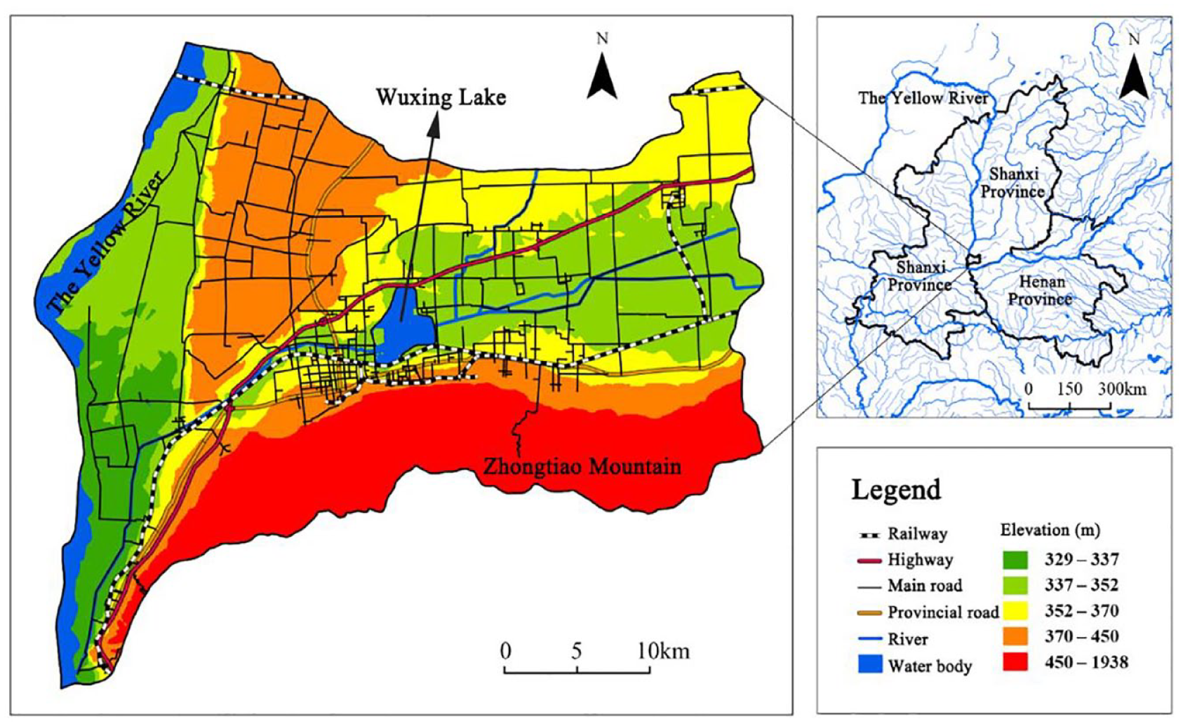
Summary map of the study area.
Data source
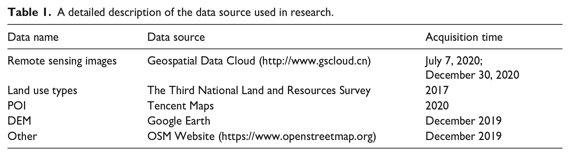
To ensure the scientific rigor and comprehensiveness of the site suitability analysis process, this study employs multi-source geographic big data, systematically extracting and analyzing multiple layers of influential factors. Integrating these diverse data sources facilitates a quantifiable and robust analysis, which is essential for evaluating potential sites. A detailed overview of the data sources used in this research is provided below (refer to Table 1):
A detailed description of the data source used in research.
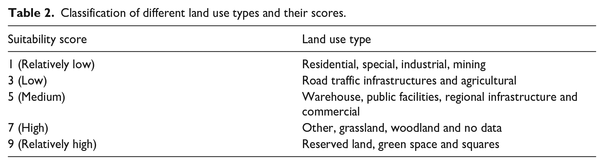
Classification of different land use types and their scores.
Methods
Indicator system
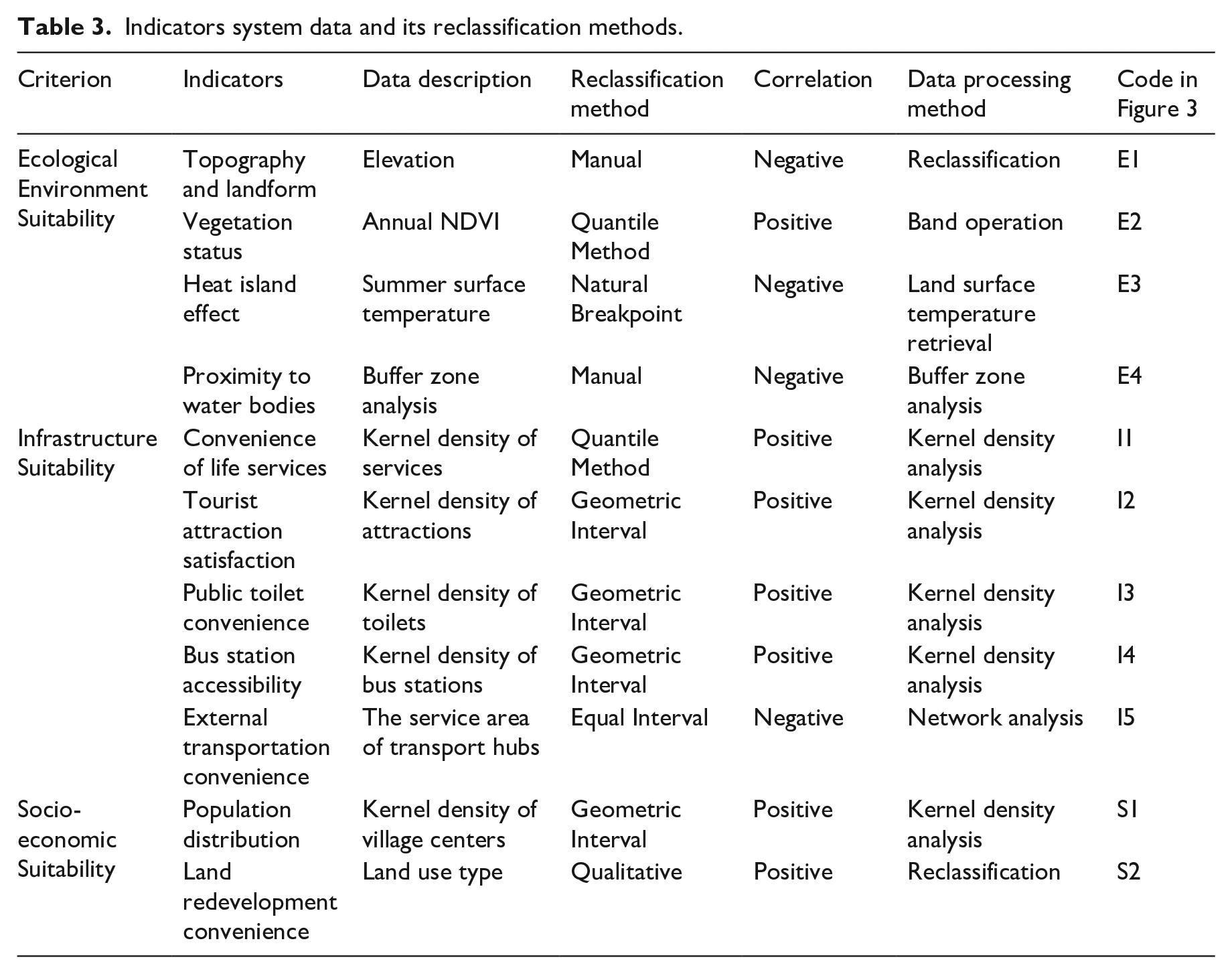
This research develops a robust evaluation indicator system that incorporates 11 factors across three critical dimensions—ecological environment suitability, infrastructure suitability, and socio-economic suitability—based on the three fundamental attributes that urban eco-parks must embody and drawing from a diverse range of foundational studies (Luo and Yang, 2018; Wang et al., 2020; Xiao et al., 2015; Yi et al., 2020; Zhan et al., 2016; Zhao et al., 2016). A more detailed description of the indicators is provided in the Online Supplementary Material . The development of this indicator system, along with the application of reclassification techniques, is informed by a series of studies addressing similar thematic areas within urban ecological planning, including assessment frameworks for infrastructure and land use types, as well as methodologies for evaluating socio-economic and environmental factors. The specific flow of experimental steps is shown in Figure 2 below.
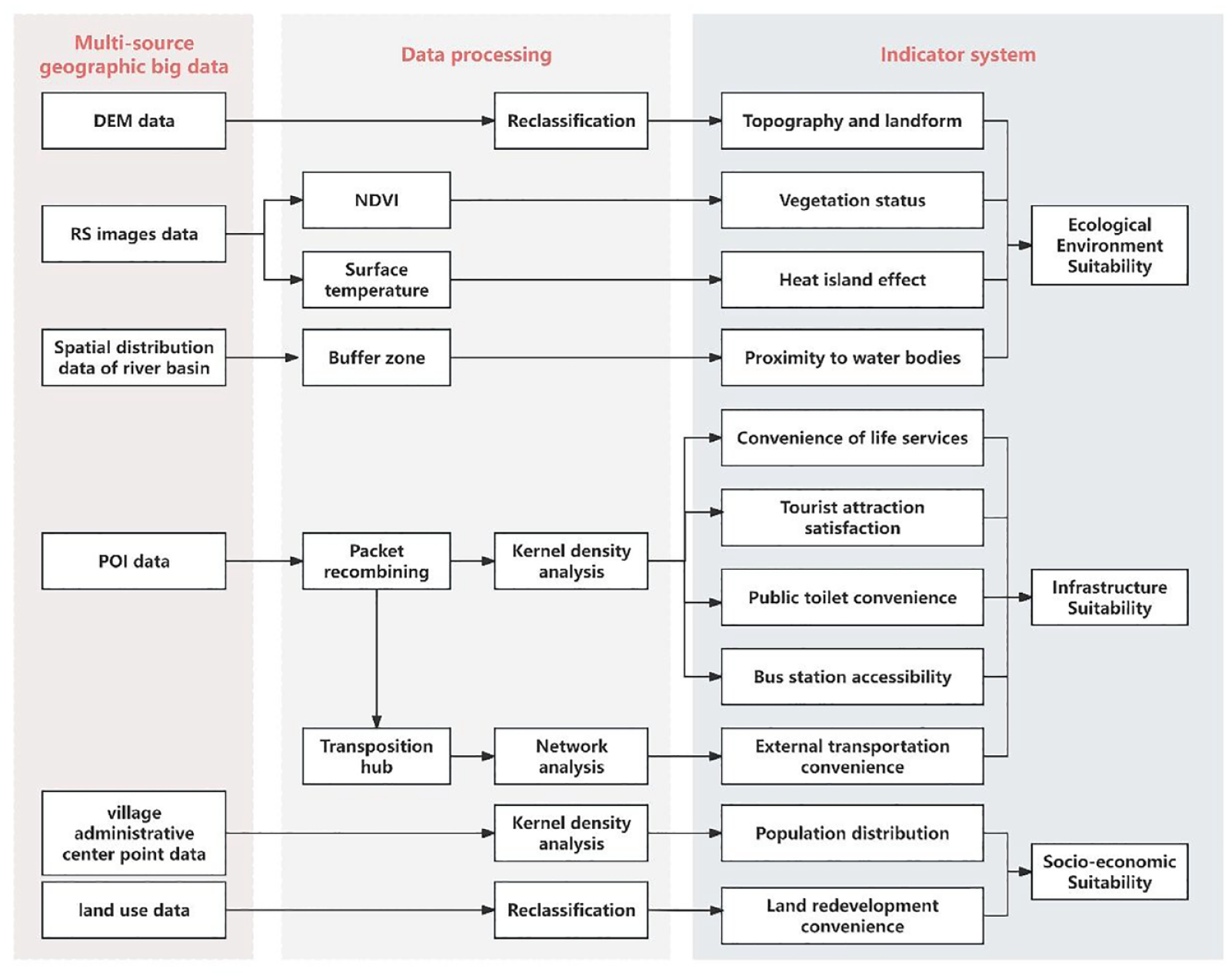
Flow chart of the experiment.
Data processing
Remote sensing
The processing of remote sensing images in this study was conducted using ENVI 5.3.1 software. The study focused on the NDVI and surface temperature to assess the condition of surface vegetation. NDVI is a widely utilized indicator for representing vegetation growth (Chen et al., 2021) and can be employed to approximate and infer land cover types and surface vegetation coverage within a specified area. The formula for calculating NDVI is as follows:
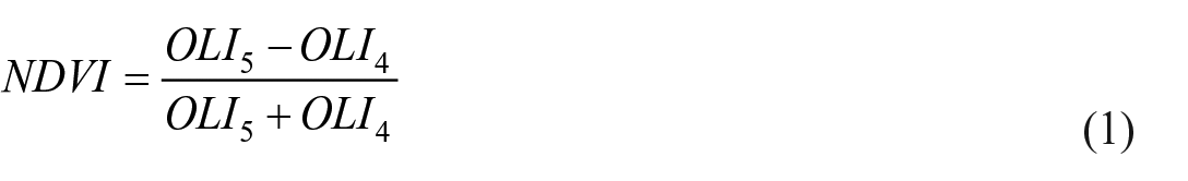
In the formula,
The thermal environment of urban areas, particularly surface temperatures during the summer, effectively reflects the urban heat island phenomenon, thereby revealing the broader characteristics of the ecological environment at a deeper level (Chen et al., 2021). The method for extracting surface temperature is presented in Formula 2.
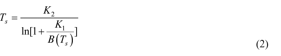
Among them, the values of parameters
Spatial analysis
This study applies spatial analysis methods, including kernel density analysis and network-based service area analysis, to process vector elements (Xu et al., 2020; Zhang and Zhao, 2018). In kernel density analysis, the spatial distribution of various point elements is examined in relation to the central urban area of Yongji City and the influence zone of Wuxing Lake, using a 2 km search radius. This radius is selected based on the average walking distance that urban residents are generally willing to cover to access public spaces. Network analysis evaluates and analyzes connectivity between targets by utilizing network nodes, distances, and impedance. Among these methods, service area analysis determines the reach or influence of facilities within a specified distance or time. Given that human mobility patterns are often shaped by road networks, accessibility is higher in areas with road access and lower in areas lacking infrastructure. This study identifies three types of transportation hubs—Yongji City’s train station, long-distance bus station, and highway exits—as key facility points to construct irregular, ring-shaped network service areas at equal intervals and different levels, thus assessing the convenience of external transportation.
Reclassification
Using ArcMap 10.5, factors are meticulously reclassified and scored to reflect varying degrees of site suitability, with scores of 1, 3, 5, 7, and 9 representing ‘Relatively Low,’ ‘Low,’ ‘Medium,’ ‘High,’ and ‘Relatively High’ suitability ratings, respectively. Detailed scores and intervals assigned to the indicators are provided in the Online Supplementary Material . Reclassification methodologies vary based on each factor’s statistical characteristics. For quantitative data (e.g., NDVI, summer surface temperature, and external transportation connectivity), reclassification is performed according to statistical relationships with suitability. Conversely, qualitative factors (e.g., land use types and landform types) are reclassified based on inherent suitability relationships, supported by relevant literature. Notably, factors such as topography, landform, summer surface temperature, and external transportation connectivity exhibit an inverse correlation with their original data values; thus, their correlations in Table 3 are negative.
Indicators system data and its reclassification methods.
Weighting
Each indicator data layer provides spatial insights into the suitability of urban ecological park locations from unique perspectives, yet their impacts on the final overlay results vary. To assign appropriate weights that reflect the interrelationships and relative importance of each factor, this study employs the Analytic Hierarchy Process (AHP) using Yaahp software. Through pairwise comparisons of criteria and sub-criteria layers, the relative importance and weights of each factor are calculated, effectively capturing both the general attributes and specific conditions of the study area.
Raster overlay
The study conducted an overlay analysis using ArcMap 10.5, where the reclassified result layers of each factor were multiplied by their respective weights and subsequently summed to produce the comprehensive site suitability result layer for Yongji City’s urban ecological park. The formula for raster weighted calculation is presented as follows (Liu et al., 2020b):
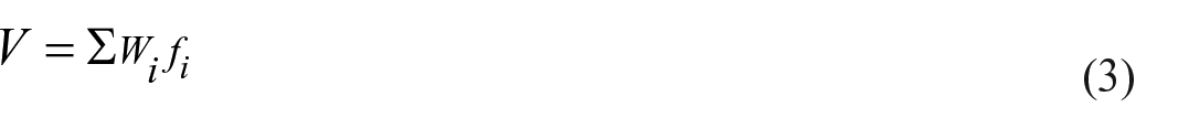
In this formula, for each pixel involved in the raster calculation, V represents the calculated result value, f is the raster value of the single-factor layer, W is the corresponding weight, and i is the factor index .
Results
Suitability assessment
Reclassification results
Figure 3 presents the reclassification results, which demonstrate a distinct gradient of suitability across the study area, thereby underscoring the variability in spatial suitability. High-suitability areas are characterized by optimal vegetation cover, lower summer surface temperatures, and strong transportation connectivity, which support their potential as ecological park sites. These areas typically exhibit stable topography, high ecological value, and moderate levels of human activity. In contrast, low-suitability zones are located in areas with elevated surface temperatures and minimal vegetation, indicating limitations in ecological functionality and accessibility for urban residents.
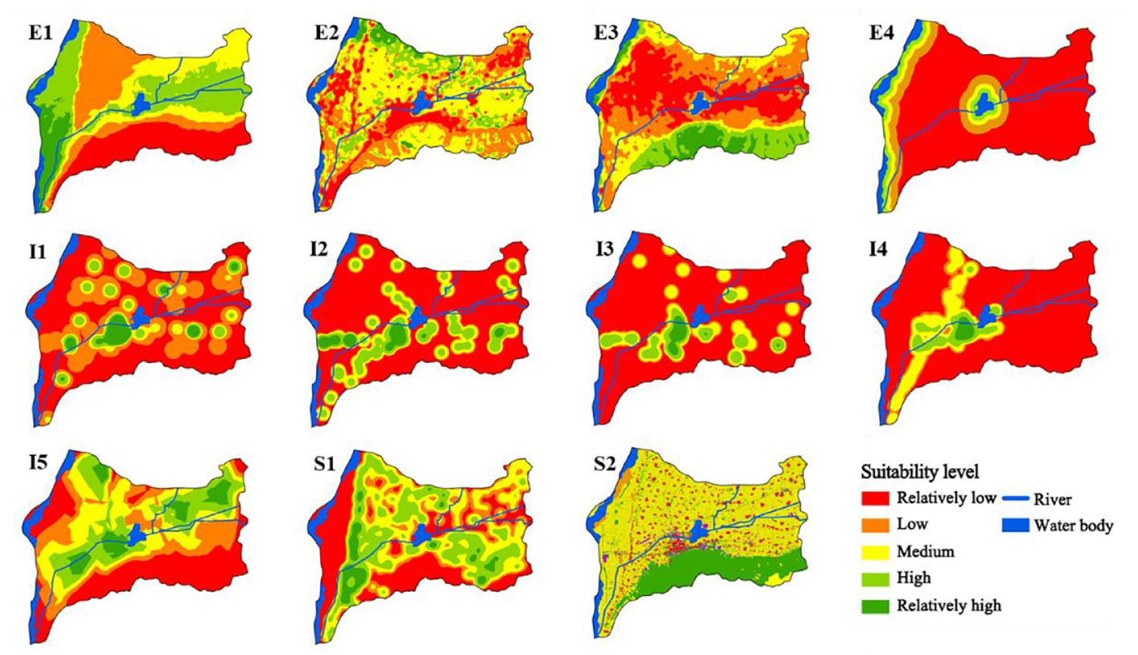
Suitability level map of each indicator.
Weight results
The results of the weighting calculations are presented in Table 4.
Weights of criteria and indicators using the AHP method.
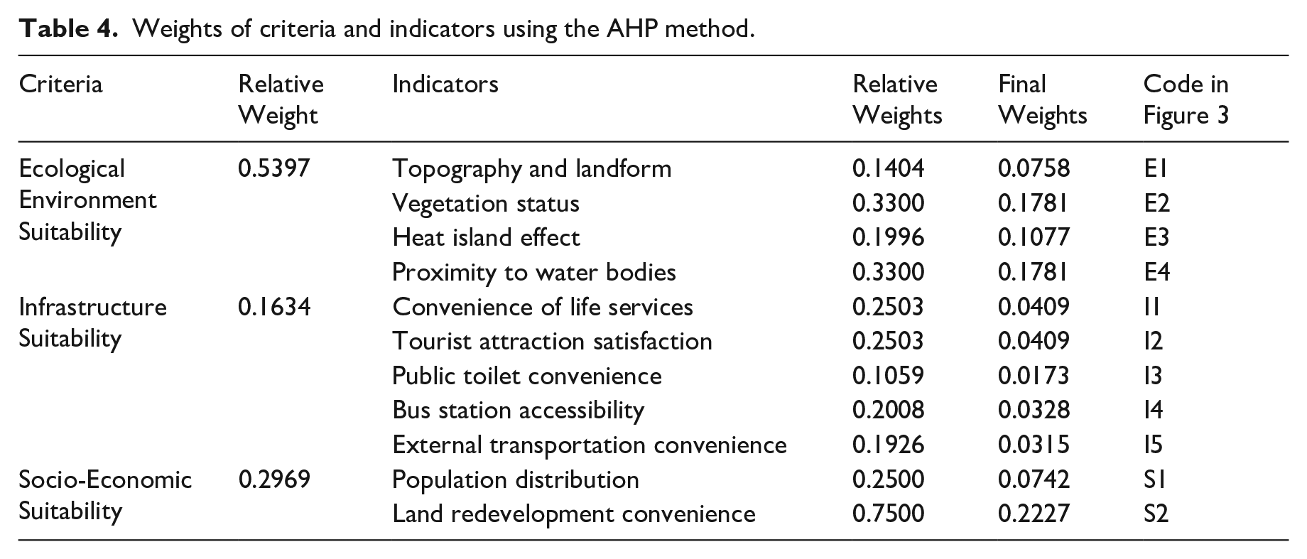
This nuanced weighting approach rigorously evaluates each factor, accurately reflecting its specific impact on the suitability of urban ecological park sites. By integrating these weighted factors, the study presents a comprehensive framework for selecting optimal park locations that support environmental sustainability, infrastructural adequacy, and socio-economic benefits.
Evaluation
The weighted overlay of the factor layers was conducted, and the natural breaks method was used for classification and mapping, as shown in Figure 4.
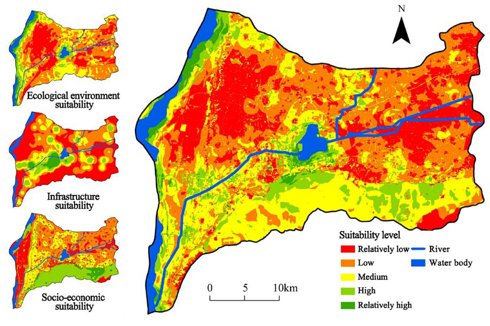
Comprehensive suitability of Yongji urban ecological park site selection.
The results indicate that areas with high ecological environment suitability are predominantly located within hydrophilic ecological landscapes, such as the mudflats along the Yellow River and the surroundings of Wuxing Lake Wetland. These wetlands and water bodies not only offer high-value natural landscapes but also positively influence vegetation coverage and local climate conditions.
In contrast, infrastructure suitability is largely influenced by urban layout. High-suitability zones are concentrated within Yongji City’s main urban area and around various town administrative centers, extending along major transportation routes. For socio-economic suitability, high-value regions are primarily situated in the southern mountainous areas, especially near the Wulao Peak Scenic Area, which requires minimal restoration and land-use transformation costs. Only a few areas deviate from this general trend.
Additionally, the issues in the regions marked as relatively low (in red) on the resulting map warrant attention. The gentle-sloped loess areas in the northwest, at a slightly higher elevation, face severe water scarcity due to their proximity to the Yellow River bank and the Loess Plateau, necessitating comprehensive wind and sand control measures and the installation of water diversion channels. The plains in the east, designated as key agricultural zones, require a more scientific approach to agricultural practices to reduce soil exposure, maintain a balance between natural ecosystems and economic productivity, and achieve long-term sustainable development.
Optimal site selection
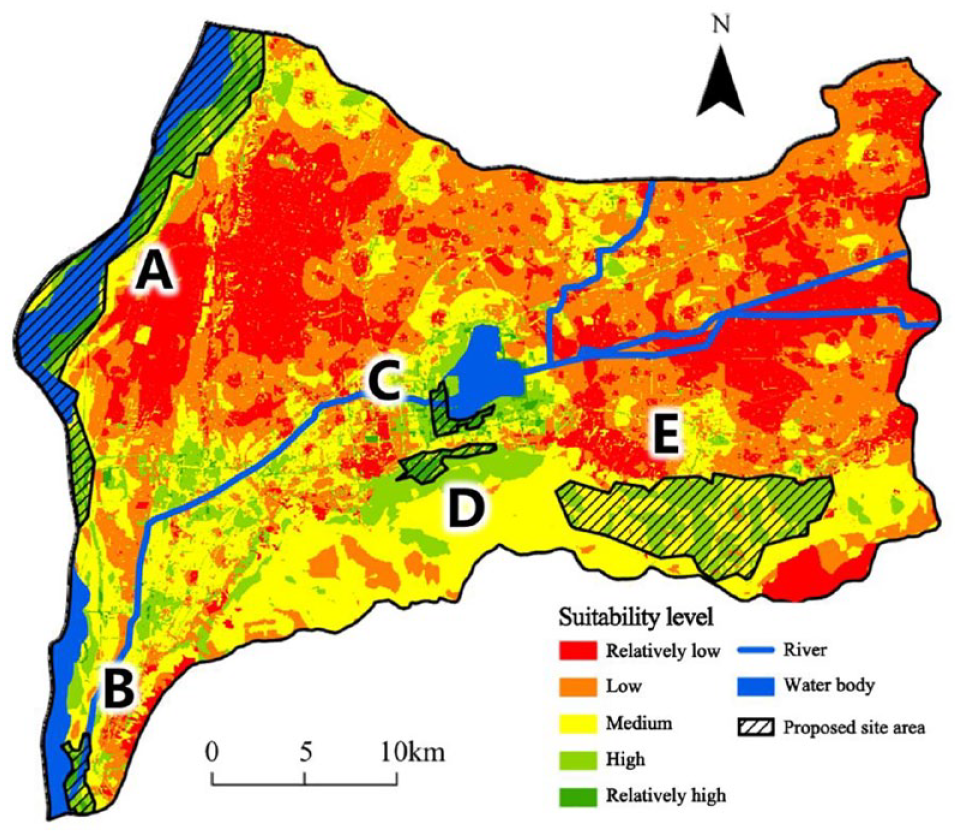
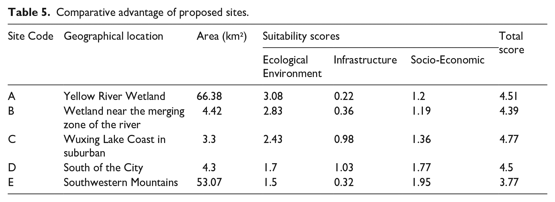
Considering the results across the 11 factors and three criteria, the sites that are suitable for building an urban ecological park in Yongji City are mainly distributed in five regions:
A: Yellow River wetland
B: Wetland near the merging zone of the river
C: Wuxing Lake coast in suburban
D: South of the city
E: Southwestern mountains
Each of these regions exhibits high overall suitability for park site selection, but with distinct factors and dominant elements, offering unique advantages and disadvantages (Figure 5).
Map of top five optimal sites for the urban ecological park.
For each of these five candidate sites, regional statistics were employed to calculate suitability scores for ecological environment, infrastructure, and socio-economic aspects, yielding an overall composite score. Suitability for each area was subsequently assessed and compared, taking into account regional characteristics, relative advantages, and other relevant factors, as detailed in Table 5.
Comparative advantage of proposed sites.
Above all, multi-source geographic big data enhances site suitability analysis by integrating detailed spatial data on environmental, infrastructural, and socio-economic factors. It enables precise assessment of ecological suitability (e.g., vegetation, water bodies), infrastructure access (e.g., transport, amenities), and socio-economic context (e.g., population density, land use). This comprehensive approach supports informed and sustainable site suitability analysis decisions.
In general, most candidate sites—except Site E—are located near hydrophilic ecological landscapes, underscoring the significance of water bodies in the semi-arid Loess Plateau region. These water-related ecological processes are vital to the overall ecological environment and positively influence local climate and vegetation. Consequently, these areas enhance suitability for local tourism and recreational development and present ideal locations for new lakeside and riverside ecological parks.
Furthermore, improved infrastructure and favorable socio-economic conditions on the urban outskirts increase the overall suitability of these locations. Sites C and D, closer to the city center, receive higher scores in both infrastructure and socio-economic suitability. Conversely, areas remote from population centers often struggle with poor transportation, limited infrastructure, and low levels of development, which reduce their suitability for urban ecological parks. Nevertheless, sites with favorable natural conditions in these distant areas could be considered for tourism development and ecological conservation.
In summary, the optimal location for the urban ecological park is Site C, situated in the southwestern suburban area near Wuxing Lake. This site offers advantages such as proximity to lake wetlands, robust infrastructure, and low land modification costs. Other suitable areas may be developed in phases according to their suitability characteristics. Sites B and D, with strong transportation links and infrastructure, are ideal for the second phase of ecological park development. Meanwhile, Sites A and E, due to their larger size, should prioritize ecological protection and consider the integration of low-impact ecotourism initiatives.
Discussion
This study leverages multi-source geographic big data to elucidate the refined and precise characteristics essential for small- and medium-scale spatial analyses, comprehensively quantifying suitability factors, including the natural environment, infrastructure, and socio-economic conditions. Through the integration of high-resolution satellite data, we assessed the ecological environment, while POI data facilitated precise infrastructure localization (Xu et al., 2019). Additionally, population and land use data provided a basis for evaluating park service effectiveness and identifying construction challenges (Yin et al., 2008). This approach enables an accurate, quantitative methodology for urban ecological park site suitability analysis.
Urban ecological parks serve crucial environmental and social functions, demanding a careful equilibrium between ecological, infrastructural, and socio-economic factors to determine optimal locations (Liu et al., 2009 ; Yan and Liu, 2021). Previous research primarily highlights ecological benefits such as biodiversity conservation and urban climate regulation (Li et al., 2015; Wang et al., 2019). However, the evaluation metrics and methodologies used in this study extend beyond these traditional focuses. By employing a multi-source geographic data framework, this study addresses data scarcity issues typically encountered in small- and medium-sized cities during detailed planning phases. It also provides a more nuanced balance among ecological, infrastructural, and socio-economic factors. Although similar methodologies have been applied in larger urban contexts (Pei et al., 2019; Shang and Mou, 2021; Zhang, 2024), their application to small- and medium-sized cities, such as Yongji, remains limited. This study fills a critical gap by adapting these methods for detailed planning in smaller urban contexts, offering valuable insights and benchmarks for other cities with similar characteristics Zhang, 2019.
While the framework presented here establishes a solid foundation for urban ecological park site suitability analysis, several limitations persist. First, the absence of long-term time-series surface monitoring data within the study area limits the temporal resolution of vegetation assessments (Guo et al., 2019). Furthermore, incorporating urban social survey data could enhance the accuracy of assessments related to visitor capacity and tourism potential (Li et al., 2020). Future research should prioritize integrating long-term ecological monitoring data and conducting comprehensive social surveys to capture dynamic urban population needs more accurately (Guo, 2009; Zhao and Peng, 2024). Such advancements will enable urban planning methodologies to become increasingly adaptive, responding effectively to evolving urban and environmental conditions over time (Liu et al., 2022).
Conclusion
This study demonstrates the potential of leveraging multi-source geographic big data to significantly improve the precision and depth of site suitability analysis processes for small- to medium-sized urban ecological parks. Addressing the limitations inherent in traditional methodologies, it establishes a comprehensive framework that integrates diverse datasets—including remote sensing, POI, and land use data—to enable a balanced evaluation of ecological, infrastructural, and socio-economic factors. Using Yongji City as a case study, this approach effectively synthesizes these data sources, producing a holistic and detailed assessment. The primary findings are as follows:
Multi-source geographic big data effectively mitigates data limitations commonly encountered in urban ecological park site suitability analysis for smaller urban areas. Remote sensing data provided critical insights into ecological variables, such as surface temperature and vegetation cover, while POI data enabled a detailed analysis of infrastructural elements. Additionally, socio-economic conditions were assessed through land use and population distribution metrics, enabling a comprehensive and well-rounded evaluation.
The study highlights the Yellow River mudflats and Wuxing Lake Wetland as key areas for ecological park development, owing to their substantial urban cooling and ecological benefits. These water-adjacent areas support enhanced ecological processes that are vital for improving local climate conditions and biodiversity.
The optimal Site Selection, Zone C, is located southwest of Wuxing Lake, and emerged as the most suitable site for park development due to its advantageous natural features and high accessibility. Recommendations for phased development of additional sites are provided, with development strategies tailored to the unique characteristics of each location.
In summary, this research introduces a robust methodological framework that advances urban ecological park planning for small- to medium-sized cities by capitalizing on the analytical strengths of geographic big data. This approach contributes to urban livability and ecological sustainability, setting a benchmark for similar urban environments.
Supplemental Material
sj-docx-1-tee-10.1177_2754124X241302041 – Supplemental material for Suitability analysis of ecological park site selection in small and medium-sized cities based on multi-source geographic big data
Supplemental material, sj-docx-1-tee-10.1177_2754124X241302041 for Suitability analysis of ecological park site selection in small and medium-sized cities based on multi-source geographic big data by Chenfeng Cai, Xiaoqian Liu, Sike Ma, Peng Peng and Ziyuan Ma in Transactions in Earth, Environment, and Sustainability
Supplemental Material
sj-docx-2-tee-10.1177_2754124X241302041 – Supplemental material for Suitability analysis of ecological park site selection in small and medium-sized cities based on multi-source geographic big data
Supplemental material, sj-docx-2-tee-10.1177_2754124X241302041 for Suitability analysis of ecological park site selection in small and medium-sized cities based on multi-source geographic big data by Chenfeng Cai, Xiaoqian Liu, Sike Ma, Peng Peng and Ziyuan Ma in Transactions in Earth, Environment, and Sustainability
Footnotes
Author Contributions
All authors contributed to the study conception and design. Chenfeng Cai was responsible for data processing, generating graphs, and manuscript writing and editing. Xiaoqian Liu provided funding, guidance for research framework, and direction for paper writing. Sike Ma was in charge of data processing and keyword clustering. Peng Peng handled data collection and graph processing. Ziyuan Ma was responsible for data processing. All authors have read and agreed to the published version of the manuscript.
Declaration of conflicting interests
The author(s) declared no potential conflicts of interest with respect to the research, authorship, and/or publication of this article.
Funding
The author(s) disclosed receipt of the following financial support for the research, authorship, and/or publication of this article: This research was supported by the General Program of the National Natural Science Foundation of China (No. 42271112), General Research Project of Beijing Municipal Commission of Education Science (No. KM202011417008).
Supplemental material
Supplemental material for this article is available online.
Author biographies
References
Supplementary Material
Please find the following supplemental material available below.
For Open Access articles published under a Creative Commons License, all supplemental material carries the same license as the article it is associated with.
For non-Open Access articles published, all supplemental material carries a non-exclusive license, and permission requests for re-use of supplemental material or any part of supplemental material shall be sent directly to the copyright owner as specified in the copyright notice associated with the article.