
Abstract
Evaluations of ecosystem services values (ESV) and ecological risk (ER) are crucially important for sustainable ecosystem management and ecological security. While numerous studies have been conducted for ecosystem service values and ecological risk assessment, respectively, few studies have investigated their linkage and correlation, especially from a social-ecological perspective. Additionally, the correlation is inconsistent, varying among studies conducted at different spatial scales, which makes it difficult to apply to a building regional ecological security pattern. Here, taking the Yongding River basin, China as an example, we first quantified the spatiotemporal variation of ecosystem service values and ecological risk from 2000 to 2020 using the evaluation models of ecosystem service and ecological risk. We then explored the spatiotemporal correlation between ecosystem service values and ecological risk by using bivariate spatial autocorrelation model to identify areas where prioritized ecosystem management is required in the process of urbanization and ecological restoration. We found: (1) the total ecosystem service value in the basin decreased first, but then continued to increase. The ecosystem service value in 2020 was 679.27 million yuan lower than that in 2000. The ecosystem service values had large spatial variations, with higher ecosystem service values in mountainous areas along the distribution of the river systems. (2) Ecological risk also varied in space, with most areas having low and medium risk levels in 2020, resulting from an overall continued decrease of the ecological risk, and a shift from medium, high, and extremely high ecological risk to low and extremely low in general. (3) There was a negative spatial correlation between ecosystem service value and ecological risk, showing widely distributed “Low ecological risk vs High ecosystem service value” in non-urbanized areas, and “High ecological risk vs Low ecosystem service value” located in newly constructed land in the southeast corner of the watershed dominated. This is a result of combined effects of urban expansion and ecological restoration. Our findings can provide insights on regulation of ecological risk in the Yongding River basin, help build a regional ecological security pattern, and achieve sustainable development.
Introduction
Rapid urbanization has caused a series of negative impacts on the eco-environment directly or indirectly through drastic changes in landscape types (Grimm et al., 2008; Zhou et al., 2022), such as habitat area shrinkage (Shochat et al., 2010), biodiversity loss (Zhou et al., 2017), and environmental pollution (Miller and Hutchins, 2017), which raises ecological risks and further affects human well-being (Xia et al., 2018; Yi et al., 2018). To ensure regional ecological security and sustainable development of human society, research related to ecological quality and ecosystem security has become a hot topic (Lin et al., 2019). Ecosystem services are the various benefits that humans obtain from ecosystems, including tangible material product supply and intangible service provision (Costanza et al., 1997; Daily et al., 1997). Their value assessment is an important basis and foundation for achieving ecosystem safety, which can quantitatively characterize the positive side of ecological safety. Ecological risk refers to the possible adverse consequences of the interaction of landscape patterns and ecological processes under the influence of natural or human factors, and ecological risk assessment is a prerequisite for prediction and risk control of future development and changes in ecological conditions, and can characterize ecological safety from the opposite side (Piet et al., 2017).
Both ecosystem service evaluation and ecological risk evaluation are important types of eco-environmental evaluation (Tian and Gang, 2012), and there is an increasing interest in the integration of the two types of assessment (Chen et al., 2011; Hommen et al., 2010; Van der Biest et al., 2014). Many studies tried to put ecosystem services into ecological risk evaluation, for example, Cao et al. introduced ecosystem services into risk evaluation and constructed a framework for an ecosystem service based landscape ecological risk assessment (ESRISK) (Cao et al., 2018); Liao et al. used important ecosystem service areas as risk receptors to conduct a comprehensive evaluation and prediction of urban integrated ecological risk in Xiamen city (Liao et al., 2018); Ouyang et al. used a combination of ecosystem service assessment models, ecosystem health assessment models, and correlation analysis to evaluate ecological risk in Changsha-Zhuzhou-Xiangtan urban agglomeration and classified the degree of risk (Ouyang et al., 2020); Gong et al. integrated ecosystem services and ecological risk into adaptive management at the landscape scale (Gong et al., 2021).
The integration of ecosystem service valuation and ecological risk assessment can provide more comprehensive insights for regional ecological security. Therefore, there has been an increasing interest in the integration of these two (Jia et al., 2020; Xu et al., 2021; Zhang et al., 2022). However, previous studies have shown that the spatial relationship between the two is inconsistent, varying among studies conducted at different spatial scales. For example, Jia et al. (2022) found a positive spatial correlation between the total ecosystem service value per unit area and ecological risk index in Wuhu city. However, Xu and colleagues discovered a negative correlation in 2000, but positive ones in 2009 and 2015 in Fuzhou city. In contrast, Zhang et al. (2022) found that the correlation between landscape ecological risk and ecosystem services was not significant in Xi’an Metropolitan Area. Such inconsistency can be related to the different spatial units and the scale at which the case studies were conducted. A previous study has indicated that biophysically meaningful units such as watersheds, rather than grids or administrative units, can be more appropriate for such analysis to address the mismatch between ecological processes and human management (Zhao et al., 2018). Additionally, it is necessary to explore the temporal and spatial characteristics of ecosystem service value and ecological risk and the correlation mechanism between them, which can help achieve sustainable development of regional socio-ecological systems (Ouyang et al., 2016; Reyers and Selig, 2020).
With an area of 74,000 square kilometers, the Yongding River basin covers 43 counties and cities in Beijing, Tianjin, Hebei, Shanxi and Inner Mongolia, containing a vast population and economy. It is a typical area with strong social and ecological interactions, as well as a concentration of conflicts between development and protection. Socio-economic development, excessive resource extraction and unreasonable land use have led to the degradation of ecosystem service functions and an increase of ecological risks in the watershed, seriously hindering sustainable development. To ensure ecological security, a series of ecological restoration measures, such as a green corridor construction, have been carried out in the Yongding River basin since 2000. Furthermore, the basin is located at the intersection of large ecological restoration projects such as Grain for Green Project and Beijing-Tianjin Sand-Storm Source Project. In the context of simultaneous urbanization and ecological restoration, the landscape patterns of the watershed have changed dramatically, and its social-ecological system has also undergone drastic transformation.
Taking the Yongding River basin, China, as a case study, we systematically analyze the temporal and spatial variation of ecosystem service value and ecological risk from 2000 to 2020 and their spatial association. The main objectives are to: (1) evaluate the temporal and spatial distribution patterns of ecosystem services values (ESV) and ecological risk (ER); (2) explore the correlation between ESV and ER in a typical study area with a complex human activity context of urbanization and ecological restoration; and (3) identify the key areas for ecological restoration in the study area according to the research results. Results from this study can provide guidance for ecosystem service value enhancement, ecological risk prevention, and ecological restoration and protection in the study area.
Materials and methods
Study area
The Yongding River consists of two major tributaries, Yanghe River and Sanggan River, and flows through Inner Mongolia, the Shanxi and Hebei provinces, as well as Beijing and Tianjin municipalities. It is one of the seven major parts of the Haihe River basin, with a total length of 747 km and a watershed area of 47,000 square kilometers, covering the northwestern ecological containment area, the central core function area and the eastern coastal development area of Beijing-Tianjin-Hebei (Figure 1). It plays an important role in ensuring flood control safety, water supply and water source protection. With excessive involvement of human activities in urbanization, the watershed is facing ecological space shortage, eco-environmental crises such as flow breakage, deforestation, and soil erosion. Meanwhile, a series of ecological restoration measures have been implemented in the watershed since 2000, and the landscape patterns have undergone a drastic change, with consequent changes in the value of ecosystem services and ecological risks.
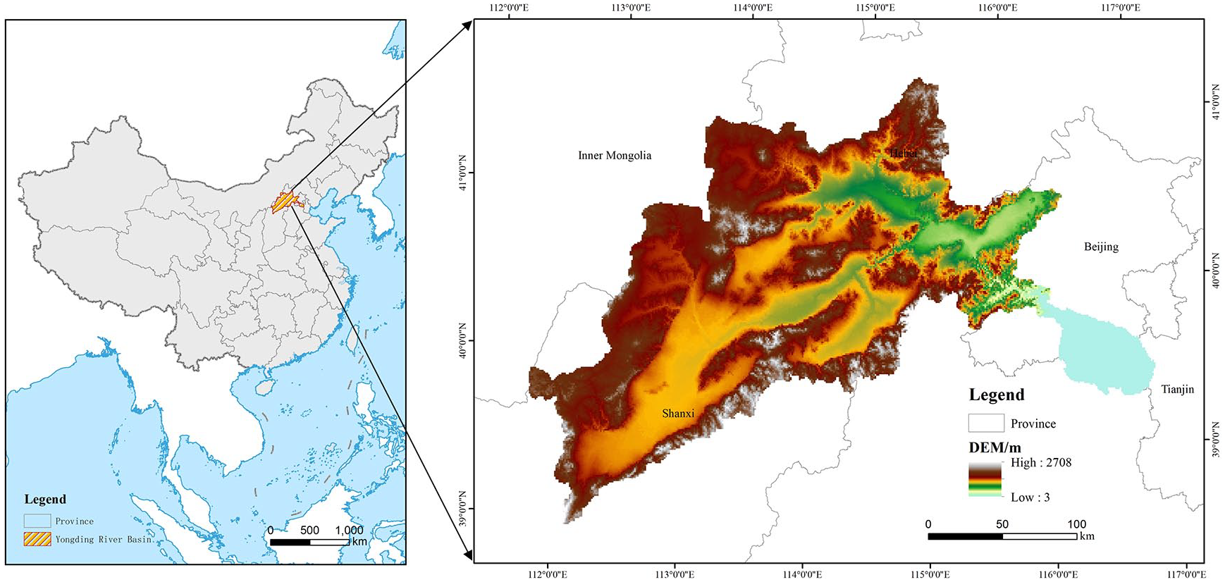
Location of the study area.
Data sources and processing
The land use data for 2000, 2010 and 2020 were obtained from the Resource and Environment Science and Data Center with a spatial resolution of 30m, which have six categories: cultivated land, forest land, grassland, wetland, construction land, and unused land. The data on the production and planted area of major crops were retrieved from the provincial statistical yearbooks of Beijing, Tianjin, Hebei, Shanxi and Inner Mongolia, and the data on the average production and average price of grain were obtained from the National Farm Product Cost-benefit Survey.
Considering the relevant study (Jia et al., 2020) and computing efficiency, we used a 5 km×5 km grid to resample the study area and formed 2106 evaluation units. Based on these evaluation units, ecosystem service values and landscape ecological risk were calculated and assigned to the central points of the evaluation units, then kriging interpolation was performed to analyze their spatial pattern distribution characteristics, finally the correlation between ESV and ER were explored to identify the key areas for ecological restoration in the Yongding River basin (Figure 2).
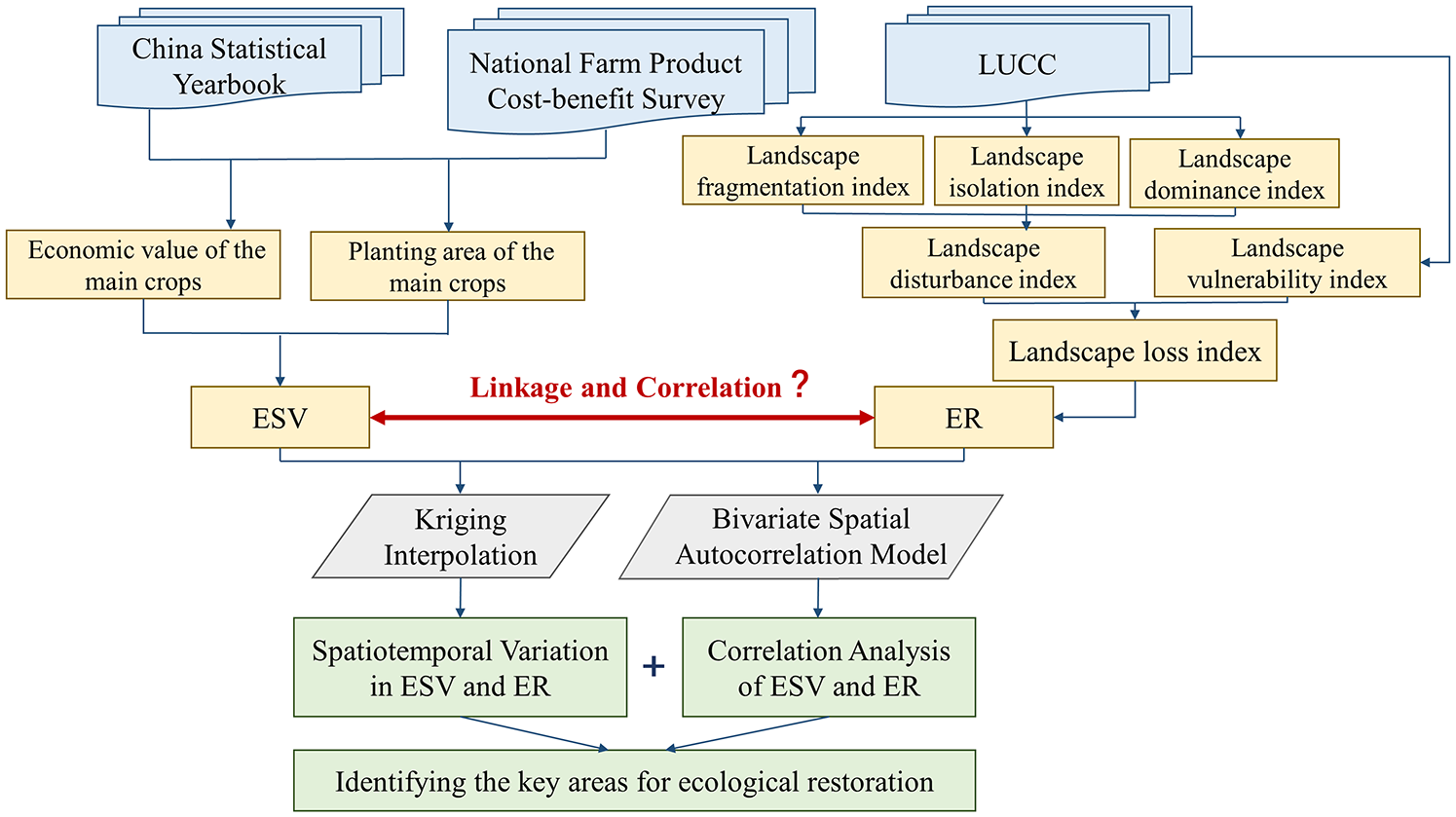
Research flowchart.
Methods
Calculation of ecosystem service values
The ESV assessment model of Costanza et al. (1997) was used to calculate the ESV of the Yongding River basin in the three periods. The formula is as follows:
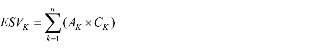
where ESV is the total ESV in the study area (yuan); n is the number of landscape types; Ck is the ESV coefficient per unit area of the landscape type k (yuan/ha); and Ak is the area of landscape type k (ha).
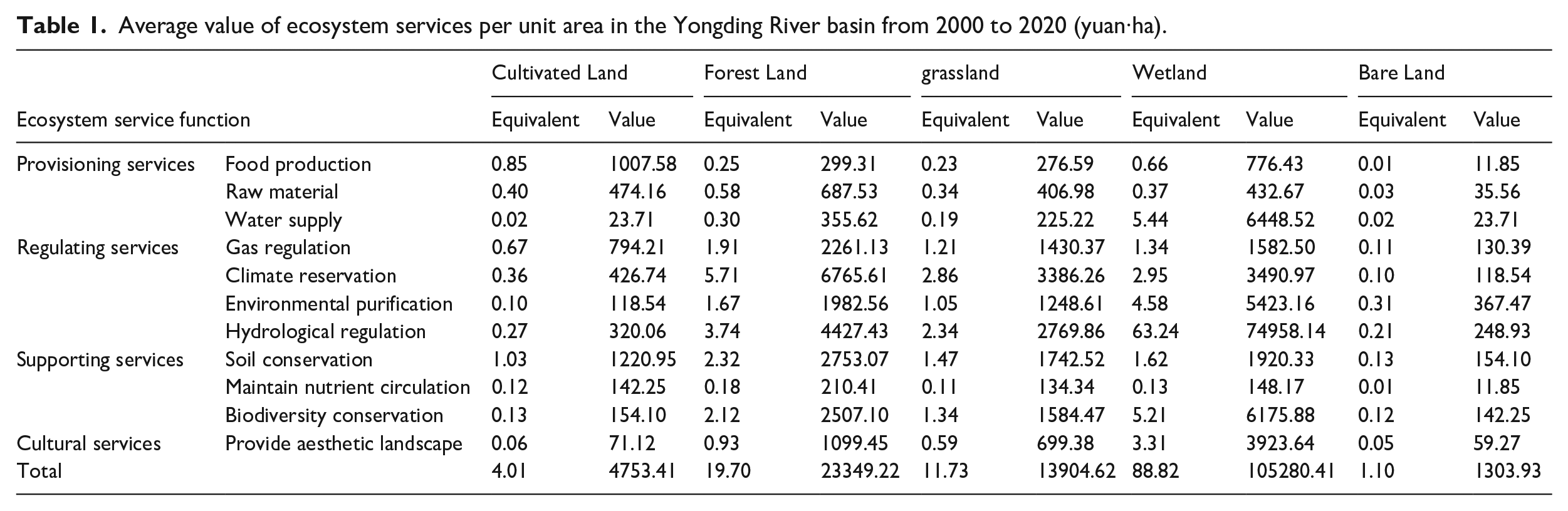
The value equivalent was modified in accordance with the ESV equivalent per unit area of China’s terrestrial ecosystem as determined by Xie et al., as well as the land use types and research requirements of the Yongding River basin (Xie et al., 2015). In this study, the ecosystem types and landscape types of the Yongding River basin were correlated. The value equivalents of cultivated land, forest land, grassland, and bare land correspond to the ecosystem types of farmland, forest, grassland, and desert, respectively. River channels, lakes, reservoirs, ponds, beaches, and marshes are all considered wetlands In this study. As a result, the equivalent value of wetland is the mean equivalent value of wetlands and river systems (Table 1). ESV reflects a utility value, so only the positive effect of ecosystem services was calculated, while construction land, including urban land, rural settlements, transportation land and industrial and mining enterprise land, is more destructive to the eco-environment and was not included in the accounting (Chen et al., 2020).
Average value of ecosystem services per unit area in the Yongding River basin from 2000 to 2020 (yuan·ha).
Following the methods detailed in Xie et al., expert knowledge-based assessment of ecosystem services can be used as to assess ecosystem services with known land use areas, but the spatial disparity of ecosystem services should be also considered (Xie et al., 2003). Therefore, we also referred to the economic values and planting areas of the main crops of each province within the Yongding River basin boundary in the provincial statistical yearbooks and the National Farm Product Cost-benefit Survey in 2000, 2010 and 2020. Based on the correction method: a standard economic value of ecosystem service equivalent factor is 1/7 of the economic value of food production per unit area of farmland. The formula is as follows:

where Ea is the economic value of the food production service function provided by the farmland ecosystem per unit area (yuan·ha), i represents different types of crops, mi is the economic value of the main crops (yuan), Mi is the planting area of the main crops (ha).
We used the average grain yield and price in 2000, 2010 and 2020 as the benchmark yield and price in the study area, and the equivalent value of ecosystem service value in the Yongding River basin was derived as 1185.39 yuan/ha according to the China Statistical Yearbook and the National Farm Product Cost-benefit Survey.
Calculation of ecological risk
The magnitude of the ecological risk is a function of the spatial combination and proportion of different landscape types (Zhou et al., 2019). Based on this, with reference to the existing research results (Dale and Kline, 2013), the Ecological Risk Index (ERI) of landscape was constructed based on the area proportion of different landscape types in each evaluation unit, which was used to evaluate the risk of ecological service function loss per unit area in the Yongding River basin and to compare the ecological risk differences per unit area. To accurately evaluate the ERI caused by different landscape patterns, the landscape pattern index model with two indices, degree of landscape disturbance and degree of landscape vulnerability, was used. The formula is as follows:

where ERIi is the ecological risk index of evaluation unit i, n is the number of evaluation units, Aki is the area of the k- type landscape in the evaluation unit k, Ak is the area of evaluation unit k, Ri is the landscape loss index of the k-type landscape. The calculation formulas and ecological significance of each parameter are shown in Table 2.
Calculation methods of landscape indices.
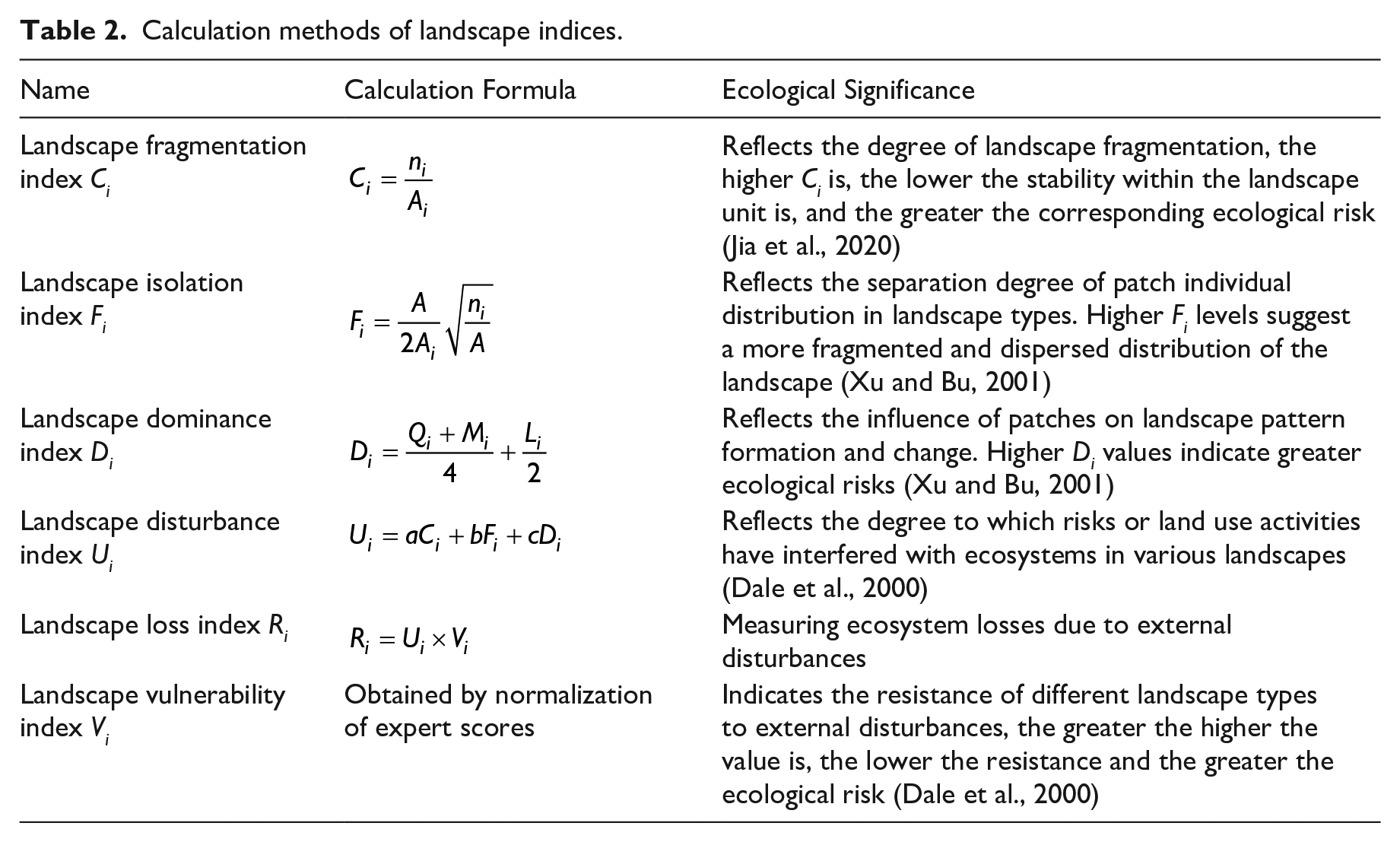
Note: ni is the number of patches of landscape type i, Ai is the total area of landscape type i, A is the total area of all landscape types, Qi is the sample number of type i pattern/total number of samples, Mi is the number of type i patches/total number of patches, Li is the area of type i patches/area of samples, a, b and c are the weights of fragmentation, isolation and dominance, respectively, and the weights of 0.5, 0.3 and 0.2 were assigned to them based on previous studies with similar geographic location or scope to our study area (Gong et al., 2015; Liu et al., 2012; Mo et al., 2017; Zhang et al., 2022).
Bivariate spatial autocorrelation model
The spatial autocorrelation model can reflect the degree of correlation of a certain factor in spatial location, including global spatial autocorrelation and local spatial autocorrelation (Ord and Getis, 2010; Wartenberg, 2010). The Moran’s I value is expressed as follows:
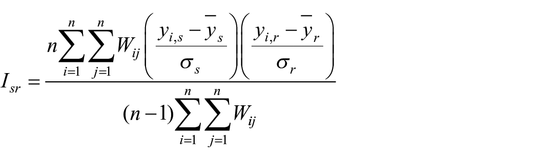
where Isr is the bivariate global autocorrelation coefficient of ecosystem services value s and ecological risk index r per unit area, yi,s and yi,r are the value of ecosystem services per unit area and ecological risk index in sampling plots i, respectively, n is the number of sampling plots,
Related scholars have extended the bivariate global autocorrelation and local autocorrelation based on Moran’s I index, which provides a method to reveal the correlation of spatial distribution of different elements (Anselin et al., 2002; Wartenberg, 2010). The formula is as follows:
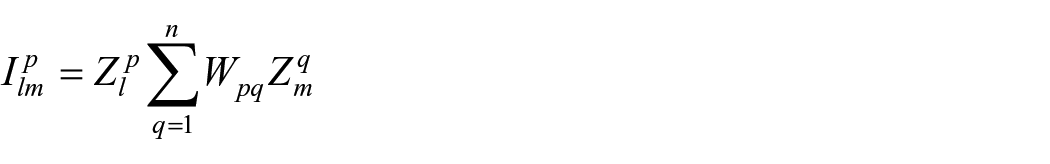
where
In this study, Moran’s scatter plot and spatial correlation local index were used to conduct spatial autocorrelation analysis based on the bivariate spatial autocorrelation model. The spatial distribution relationships were divided into high-high clustering (H-H), high-low clustering (H-L), low-high clustering (L-H), and low-low clustering (L-L) to explore the spatial correlation of ecosystem services values and ecological risks (Cheng, 2016; Souris and Bichaud, 2011). The calculations were performed in GeoDa 1.18.0.
Results
Analysis of spatiotemporal variation in ESV
Characteristics of landscape changes
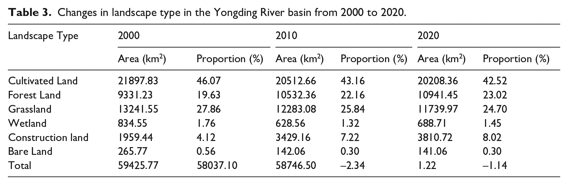
The results of landscape type change shows that the proportion of cultivated land (>42.52%), grassland (>24.70%), and forest land (>19.63%) ranked in the top three from 2000 to 2020. Cultivated land had the highest net loss of area, followed by grassland (1501.58 km2), the net increase of forest land and construction land area was the largest, increasing by 1610.23 km2 and 1851.28 km2, respectively, while the changes in wetland and bare land were unremarkable (Table 3). Besides, the spatial distribution map and Sankey map of landscape types shows that the loss of cultivated land was mostly converted to forest and construction land due to the policy of Grain for Green Project and rapid urbanization, while grassland was mostly converted to forest, cultivated land, and construction land (Figure 3).
Changes in landscape type in the Yongding River basin from 2000 to 2020.
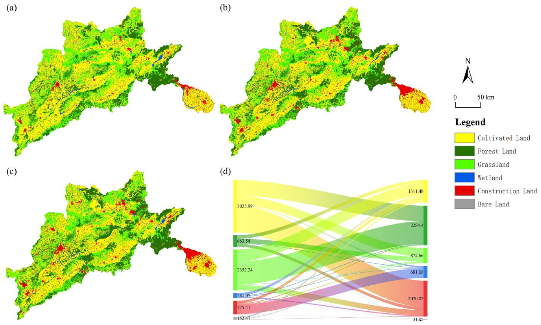
Spatial distribution of the landscape types in the Yongding River basin for (a) 2000; (b) 2010; (c) 2020 and (d) Sankey map of landscape types transfer matrix from 2000 to 2020 (km2).
Table 4 shows the amounts and changes of ESV in the Yongding River basin from 2000 to 2020. The total ESV in the Yongding River Basin was 59425.77, 58037.10, and 58746.50 million yuan in 2000, 2010, and 2020, respectively, showing a patten of first decreasing but then increasing. The total ESV decreased by 2.34% from 2000 to 2010 and increased by 1.22% from 2010 to 2020. The overall value still decreased by 679.27 million yuan during the two decades, with a change rate of -1.14%.
ESV of different landscape types and changes in the Yongding River basin from 2000 to 2020.
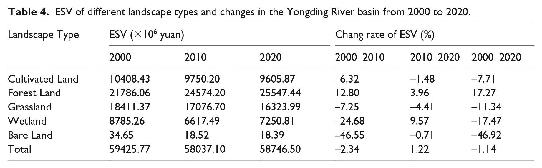
In terms of various landscape types, forest land contributes the most to the ESV of the Yongding River Basin, with a proportion above 36.66% and growing, which is due to the large area of forest land and the advantage of forest land in regulating and supporting services. While the ESV of grassland and cultivated land continued to decrease, with the change rates of -11.34% and -7.71%, respectively. Furthermore, the ESV offered by wetland decreased and then increased, but had not yet made up for the decrease, while the value of bare land continued to decrease (Table 4).
Changes in various and individual ESV
In terms of the structural function of ESV, the value of each service in descending order is as follows: regulating services > supporting services > provisioning services > cultural services (Table 5). The ESV of regulating and cultural services were increasing, and the ESV of supporting and supplying services were decreasing. The ESV of all individual service were decreasing, with the exception of the values of climate regulation (3.80%), biodiversity conservation (0.91%), environmental purification (0.67%), and aesthetic landscape (0.09%), which were increasing.
ESV of different service functions and changes in the Yongding River basin from 2000 to 2020.
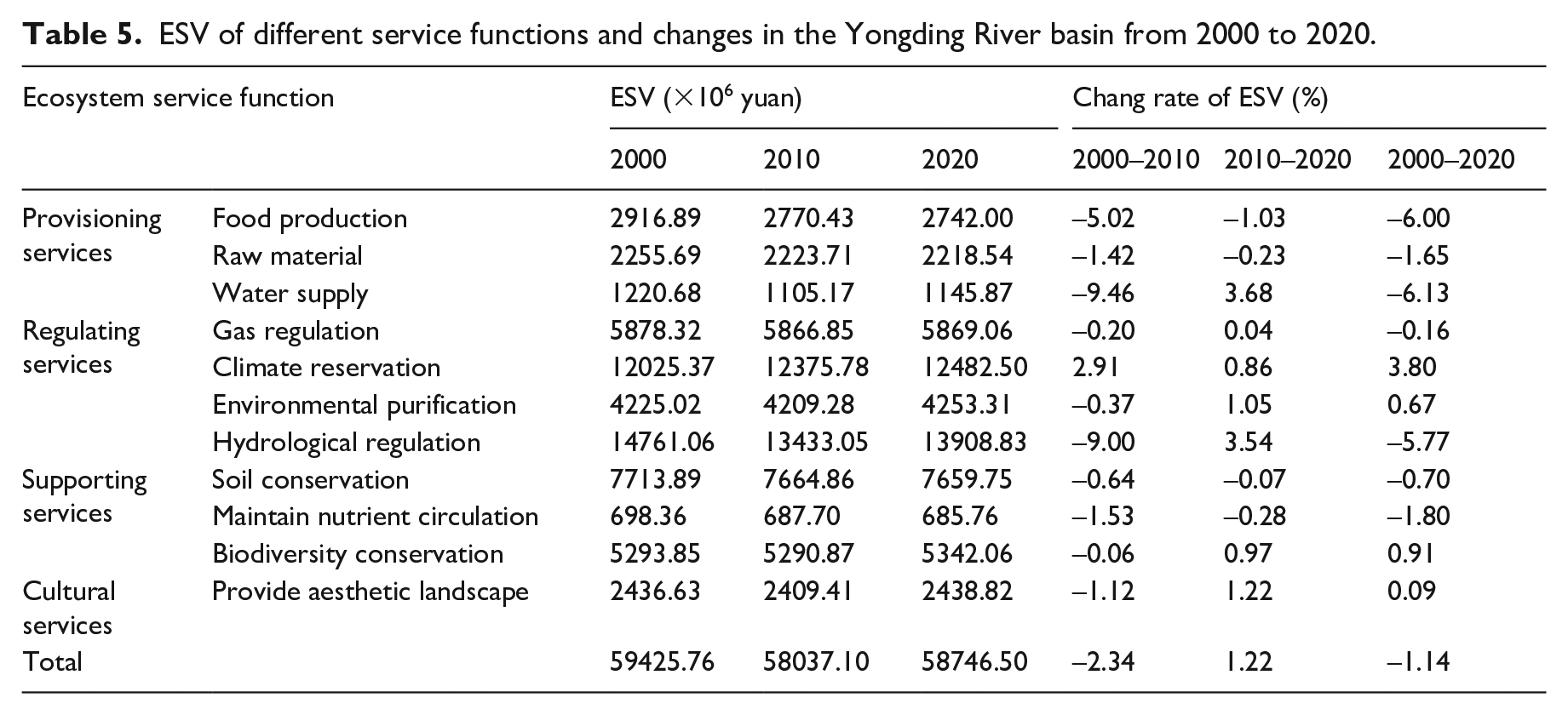
The value of hydrological regulation accounted for the highest percentage of the total ESV (>23.15%), showing a trend of first decrease and then increase, indicating that the conservation and restoration of wetland landscape in the Yongding River basin has achieved some success.
Spatial pattern of the total ESV per unit area
The total ESV was calculated, spatially interpolated, and assigned to the center point of the evaluation unit, and then divided into five levels based on the equal interval method for better visualization: extremely low ESV [0, 1500], low ESV [1500, 3000], medium ESV [3000, 4500], high ESV [4500, 6000], and extremely high ESV [6000, ∞] [×104yuan]. The spatial distribution of the total ESV per unit area in three periods was illustrated in Figure 4, and the variation of the total ESV at different grades was shown in Table 6.
Spatial distribution of total ESV per unit area in the Yongding River basin for (a) 2000; (b) 2010 and (c) 2020.
Proportion and change rate of ESV at different grades in the Yongding River basin from 2000 to 2020.
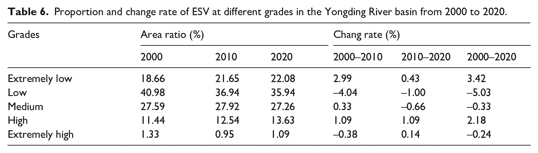
The results showed that from 2000 to 2020, the total ESV per unit area in the Yongding River basin was mainly dominated by two grades, low ESV and medium ESV, with the area accounting for more than 35.94% and 27.26%, respectively. The area of extremely low and high grades ESV showed a decreasing trend; besides, the area of low, medium and extremely high ESV showed an increasing trend. In terms of spatial distribution, ESV is higher in mountainous areas or places distributed along river systems, high ESV areas are mainly in Mentougou District, Huailai County, and Datong City, and was generally lower in urban areas. The overall changes of the total ESV per unit area were insignificant, indicating that the ecological environment of the Yongding River basin has been better protected in the context of rapid urbanization development.
Analysis of spatiotemporal variation in ER
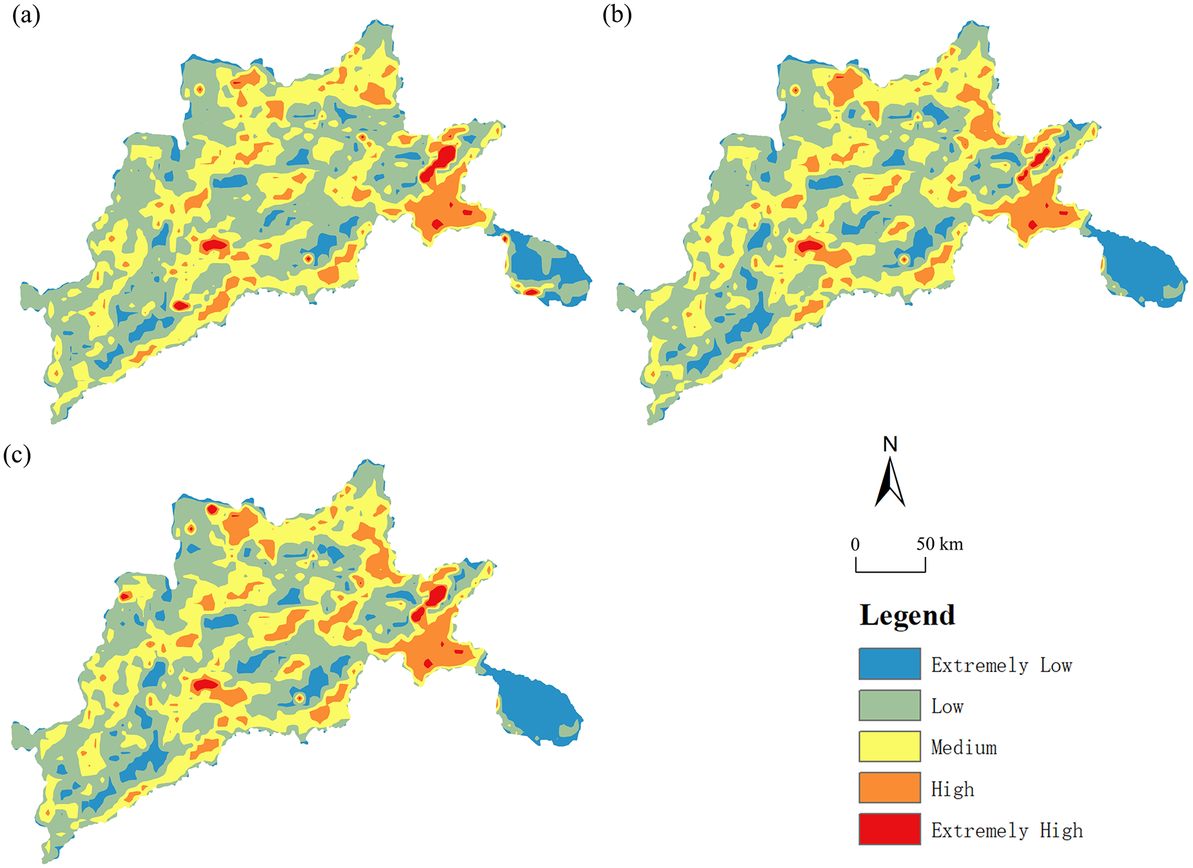
Combining the actual situation of the study area and the range of the ecological risk index (ERI) per unit area, the ecological risk was reclassified into extremely low [0, 0.022], low [0.022, 0.033], medium [0.033, 0.046], high [0.046, 0.078], and extremely high [0.078, ∞] with the natural breakpoint method. The spatial pattern distribution and area changes of ecological risk in the Yongding River basin from 2000 to 2020 are shown in Figure 5 and Table 7.
Proportion and change rate of ERI at different grades in the Yongding River basin from 2000 to 2020.
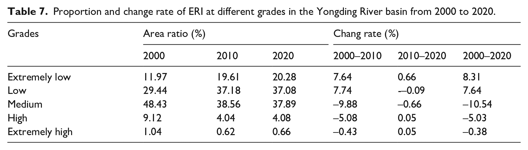
Spatial distribution of ERI per unit area in the Yongding River basin for (a) 2000; (b) 2010 and (c) 2020.
The spatial distribution of ERI in the Yongding River basin during 2000-2020 is generally striped, with obvious spatial differences, mainly in low and medium risk levels, concentrated in the eastern part of the basin, such as Mentougou District and Chongli District, which have a high proportion of forest land and grassland. High-risk areas were mostly in Huailai County, Xinghe County, Datong City, Yang Yuan County and Wei County, distributed along the river system. The ecological protection of such areas needs to be strengthened in the future. In general, the study area showed a shift from medium, high and extremely high ecological risk to low and extremely low, indicating that the eco-environment of the basin had a tendency to increase its resistance to external disturbance. The percentage of extremely low and low risk areas increased significantly, with growth rates of 8.31% and 7.64%, respectively; the percentage of medium and higher risk areas decreased, with decline rates of 10.54% and 5.03%, respectively; the percentage of high ERI areas did not change much. Overall, the ecological restoration of the Yongding River basin has been remarkable in the past 20 years.
Correlation analysis of ESV and ER
Bivariate global spatial autocorrelation
Based on GeoDa, spatial weight matrices were established to analyze the bivariate spatial correlation characteristics of ESV and ERI in the Yongding River basin. The global Moran’s I was -0.162, -0.151, and -0.116 in 2000, 2010, and 2020, respectively, indicating that there was a certain negative spatial correlation between ESV and landscape ER in the study area. In other words, the enhancement of ESV will reduce the landscape ER. This is mainly due to the disturbance brought by human activities in socio-economic development leading to landscape fragmentation, which further affects the ecosystem services value, while the correlation tended to weaken. In GeoDa, the Monte–Carlo Simulation method was used to test the significance of Moran’s I, and the P values of the three periods were all equal to 0.001, indicating that the spatial autocorrelation was significant at the 99.90% confidence level.
Bivariate local space autocorrelation
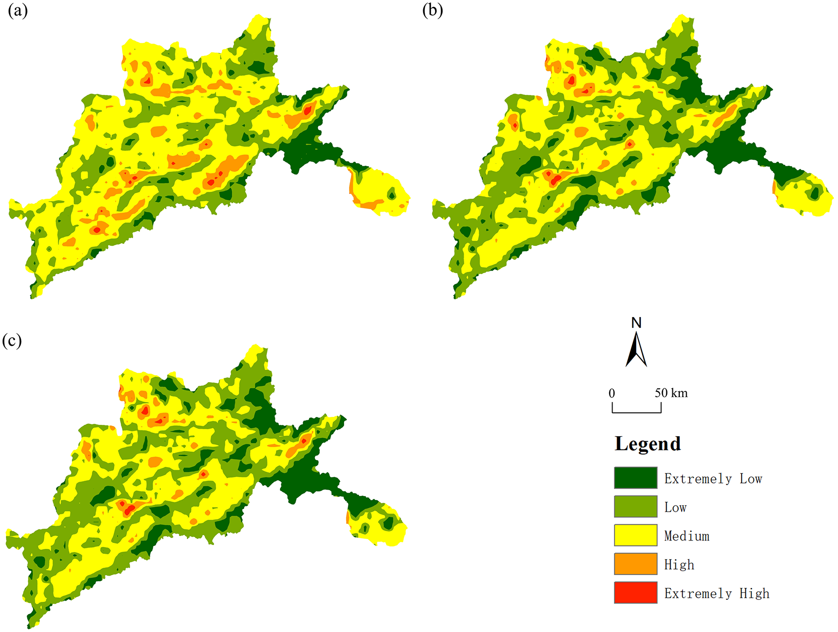
The Local Spatial Autocorrelation (LISA) clustering map is a geographical representation of the units that passed the significance test in the scatter plot. During 2000-2020, the relationships between ER and ESV in the study area were divided into five types (Figure 6): High ER vs High ESV, Low ER vs Low ESV, Low ER vs High ESV, High ER vs Low ESV and not significant zone.
Local spatial autocorrelation LISA maps from 2000 to 2020.
Proportion and change rate of ERI at different ERI-ESV relationships and local spatial autocorrelation LISA maps in the Yongding River basin from 2000 to 2020 are shown in Table 8 and Figure 6.
Proportion and change rate of different ERI-ESV relationships in the Yongding River basin from 2000 to 2020.
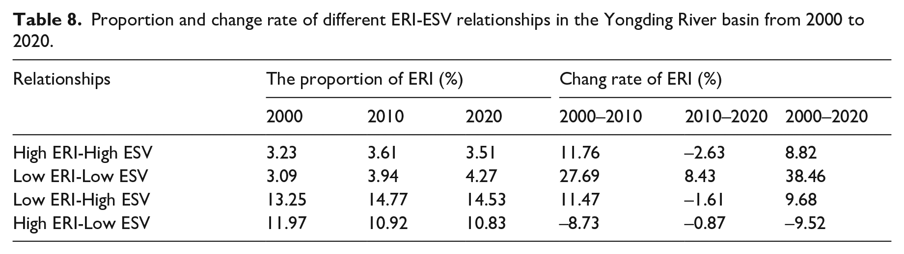
H-H represents the area with high ER rating per unit area and high ESV at the same time. This type of area accounted for a relatively high percentage (more than 10.83%) in 20 years, and showed an overall increasing trend with a growth rate of 8.82%, mainly located in wetland with larger area and capable of providing high ESV. However, the wetland faces high ecological risks of fragmentation, shrink, erosion by cultivated land and construction land, so it is necessary to strengthen the ecological protection and restoration in such areas.
L-L represents the area with low ER per unit area and low ESV. This type of area accounted for a very small percentage but high growth rate, with an area increase of 38.46% in 20 years, and is mainly located in the cultivated land around the built-up areas in the southeast corner of the watershed. This is attributed to the low contribution of cultivated land to the ESV and the ecological risk is low because it is relatively stable.
L-H represents the area with low ER per unit area and high ESV. The proportion of such areas was always the highest (more than 13.25%) and the growth rate reached 9.68%, which is the main relationship type in the basin. These areas were mostly forest land areas, such as Mentougou district and Chongli county, indicating that the implementation of many ecological restorations, such as Grain for Green Project, Beijing-Tianjin Sand-storm Source Project, and the construction of the green ecological corridor of the Yongding River, has contributed to the increase of ESV and decrease of ecological risk in this study area.
H-L represents the areas with high ER per unit area and low ESV. These areas were mainly the construction land in Daxing District of Beijing and some areas in Hebei province, located in the southeast corner of the basin, so the ESV was relatively low while the ER was high. Moreover, the area ratio had decreased by 9.52% in 20 years. Therefore, these areas need to strengthen ecological supervision to reduce ecological risks and improve ecosystem service values.
Discussion
Numerous studies have been conducted for ESV and ER assessment, respectively, but few studies have investigated their linkages and interactions, especially from a socio-ecological perspective. We first quantified the spatial and temporal heterogeneity of ESV and ER in the Yongding River watershed over a 20-year period in which the watershed has undergone the influence of both urbanization and ecological restoration. What is new in this study is that we further explored the correlation between ESV and ER with a focus on the effects of ecological restoration in the watershed and thereby can provide scientific support for the construction of regional ecological security patterns. We found that the spatiotemporal heterogeneity of ESV and ER in the basin was large and closely related to the process of ecological restoration and urbanization. Temporally the overall ESV in the study area ranged from decreasing to increasing, with an inflection point after the implementation of ecological restoration, and the ER generally showed a shift from high to low. Spatially the areas focused on restoration had higher total ESV and lower ER, and urban expansion areas had lower total ESV and higher ER. In addition, we found a significance negative spatial correlation between ESV and ER in the study area. The ratio of Low ER vs High ESV areas was the highest and is still growing, mostly located in the forest land of the basin. The High ER vs Low ESV areas that need to continue to strengthen ecological supervision are mainly located in the construction land in the southeast corner of the basin.
Integrated application of ESV and ER provides a new perspective for regional ecological safety assessment and prediction
Unlike most previous studies that assessed ESV or ER separately, the comprehensive application of ESV and ER can serve as a bridge to link human well-being and eco-environment, reflect the ecological status and development potential of the region from socio-ecological perspective. To some extent, it can better reflect the changes in ecological conditions caused by human activities, providing a newer perspective for analyzing and predicting ecological carrying capacity, and makes ecological regulation more targeted. In this study, a comprehensive assessment of ESV and ER was conducted, and we found that ER has a certain predictive effect on the change of ESV; ESV in high ER areas shows a decreasing trend, and conversely, ESV in low ER areas shows an increasing trend, which is instructive for ensuring regional ecological security. For areas with High ER vs High ESV, which are both the high ecological risk areas and main supply areas of ecosystem services, special attention should be paid to their ecological safety construction, and for areas with High ER vs Low ESV, their landscape patterns should be optimized to reduce risks and enhance values, as for areas with Low ER vs High ESV, ecological supervision and protection should be the focus.
Overlaying the results of the spatial distribution of ESV and ER we found that among the various landscape types in the Yongding River basin, forest lands have the highest contribution to the total ESV and are also the areas with high level of ER distribution, which is similar to the findings revealed by Jia and colleagues in the Yangtze River basin (Jia et al., 2022). But in other human activity-dominated areas such as cities (Li and Gao, 2019), it may be wetlands that contribute the most to the total ESV. These results underscore the need to strengthen the protection of forest lands or wetlands to reduce the disturbance by human activities such as urban expansion. Protection of the forest lands and wetlands in the watershed can enhance the overall ecological conditions and reduce ecological risks by improving the single ecosystem services value such as carbon storage and sequestration, soil retention, biodiversity conservation and so on, it can also enhance socio-economic benefits by promoting tourism. Additionally, the inconsistency of the correlation between ESV and ER among different studies warrants further research in the future.
Significant spatiotemporal heterogeneity of ESV and ER was found due to ecological restorations
We deliberately chose 2010 as the midpoint of the study period, because a series of cities in the Yongding River basin began to implement ecological restoration after that time, and we wanted to take this opportunity to objectively evaluate whether these restorations can withstand the pressure brought by urbanization to improve the ecological environment of this basin, and the results of the study do confirm this. From the perspective of time scale, due to the implementation of ecological restoration projects, the ecological security pattern changed significantly in 2010, the total ESV changed from a decreasing trend to an increase, and the ER decreased significantly. In terms of spatial distribution, the change was particularly obvious in places where restoration projects were implemented, with a significant increase in ESV and a significant decrease in ER, while the total ESV showed a decreasing trend in urban expansion areas. The results are inextricably linked to two important events, the implementation of The Yongding River Green Ecological Corridor Construction Plan in 2011 and The Yongding River Comprehensive Management and Ecological Restoration General Plan in 2016. Both programs mentioned the initial formation of the Yongding River ecological corridor in 2020 through the construction of shelter forests and water conservation forests. The results show that under the negative impact of urban expansion, ecological restoration is indeed an important factor in promoting the eco-environment and ecological security pattern of the Yongding River basin for the better.
Limitations and opportunities for future studies
There are some limitations in this study. First, this study focuses on the relationship between total ESV and ER, while the relationships between a single ESV and ER is not clear. Zhang et al. (2022) found that although the rapid urban development resulted in improvement in landscape ecological security and residential support functions, the total ecosystem services declined due to the reduction in water yield and crop production in the Xi’an Metropolitan Area, China. Therefore, the relationship between a single ESV and ER should be further explored. Furthermore, this study’s main emphasis is on the correlation between ESVs and ER results, after which further analysis of the coupling process is needed. Apart from this, the measurement of ESV and ER in this study was based on landscape types because landscape type change has a direct impact on ecosystem services and alters ESV, so new methods can be explored in subsequent studies to incorporate more social and economic factors into the accounting so that the results can guide ecological conservation more comprehensively. Finally, some studies have suggested that ESV changes are lagging relative to ER (Deacon et al., 2015) and that there are scale effects (Haase et al., 2012; Li et al., 2021), which also need to be further explored. In summary, it is of vital important to clarify the mechanisms and effects of the interactions between ecosystem services and ecological risks, and to measure services and risks from multiple perspectives and scales.
Conclusion
This paper explored the spatiotemporal patterns of ESV and ER in the Yongding River basin from 2000 to 2020, with a special focus on the correlation between them from a social-ecological perspective. Total ESV turned from a decrease to an increase in 2010, when several ecological restoration projects began to be implemented and the areas with high ESV per unit area were mainly distributed in mountainous areas and both sides of the river system where ecological restoration projects were carried out, while the ESV of built-up areas formed by urban expansion was generally low. Similarly, although overall ER was on the decline, ER in built-up areas was also higher than mountainous areas. There was a significantly negative spatial correlation between ESV and ER in the study area, which is mainly due to the disturbance brought by human socio-economic activities. Such activities resulted in landscape fragmentation that can significantly affect the ecosystem services values. Therefore, the correlation between ESV and ER should be evaluated in a spatially explicit way, and place-based knowledge is critically important. L-H has the highest area ratio (>13.25%) with a growth rate of 9.68%, and was the main relationship type area, mostly located in the forest land of the basin. H-L was mainly located in the construction land in the southeast corner of the basin, and the area share had decreased by 9.52% in 20 years. Accordingly, we recommend focusing more on conservation of forest land and wetland resources in the context of urbanization process and ecological restoration, and when implementing ecological restoration projects, the single ESV should be weighed to maximize the total benefits. These results have important theoretical and management implications for ecosystem service value improvement, ecological risk prevention, ecological restoration and protection in the Yongding River basin, and are helpful to the research of regional ecological security.
Footnotes
Declaration of conflicting interests
The author(s) declared no potential conflicts of interest with respect to the research, authorship, and/or publication of this article.
Funding
The author(s) disclosed receipt of the following financial support for the research, authorship, and/or publication of this article: This study was supported by the National Natural Science Foundation of China [grant number: 42225104].