
Abstract
Land Use Mix (LUM) has attracted attention for its potential to promote walking; however, the LUM-walking association was not universally positive. Existing research, potentially confounded by diverse LUM connotations and walking metrics, prompted our effort to establish a comprehensive framework. This framework aims to clarify LUM’s influence on walking, including various LUM indicators (mix in quantity, distance, function), multiple walking indicators (frequency, time, distance), distinct geographical background (residence, workplace), and travel types (weekly travel, weekday-exclusive travel). Besides, China’s unique context provide an opportunity to mitigate residential self-selection effects. We found that the proximity (LUM in distance) is the sole environmental factor driving increased walking frequency. While the LUM in quantity or function could enhance resident convenience by diversifying services, it occasionally diminishes walking distance and duration, potentially conflicting with public health considerations. Conversely, although exposure to high-functional mixed, low-compatibility environments may increase walking time and distance, it is more likely a compensatory behavior aimed at avoiding the negative externalities such as pollution and noises. Additionally, the placement of public transit stops will not only help ease traffic congestion but also encourage walking.
Introduction
Rapid urbanization is causing tremendous pressures on cities today. A growing number of cities are meeting the challenge of population expansion, traffic congestion, environmental degradation, and so on (Lu et al., 2021). Walking, which may provide moderate intensity activities that can be incorporated into daily life directly and decrease the share of motorized travel indirectly, has the potential to contribute to public health, energy efficiency, congestion reduction, and air pollution alleviation (Krizek et al., 2009; Omorou et al., 2020; Woodcock et al., 2007). Therefore, encouraging people to walk is recognized as one of the crucial strategies for sustainable development by urban decision makers (Sallis et al., 2016)
In the past three decades, the built environment-travel behavior research has received growing attention (Le et al., 2018; Wu et al., 2021) based on the premise that the urban built environment defines basic contexts and constraints on individual travel behavior (Zhao, 2011). This great research enthusiasm stems from the expectation that walking could produce individual and social benefits (Zhao et al., 2018). Additionally, there is recognition that policy and planning measures have the capacity to shape and transform the urban built environment (Wang, 2010). The most commonly used features of the built environment are the 5Ds, namely, population and employment “Density,” land use “Diversity,” “Design” of street networks, “Destination” accessibility, and “Distance” to transit service (Le et al., 2018). Among them, continuing interest has grown in the links between Land Use Mix (LUM) and travel behavior, influenced by the Compact City policies and New Urbanism in Western countries (Randolph, 2006). Two reasons may account for this rising interest. Firstly, land use planning approaches cover the set of policy instruments available to regulate and manage forms of land development and use in a broad sense (Zhao, 2011), which have been proven in practice. For example, the distribution of urban infrastructure facilities can be affected by the land supply, thus influencing travel behavior (Cervero and Day, 2008; Li et al., 2020). Secondly, the associations between LUM and walking remain unclear. Many studies in Western industrialized countries found that residents living in a community with higher LUM are likely to drive less and walk more (Tewahade et al., 2019), whereas some studies in China did not report the expected associations (Feng, 2016).
However, considering the difference in the social context and the development speed, knowledge about the correlates of walking from developed countries may not necessarily be transferable to developing countries. Since the 1980s, China has experienced economic reforms from the central planning economy to the market economy, followed by the urban built environment changing at an incredible speed. By the end of 2021, the urbanization rate of China’s permanent residents has reached 64.72%, with the urban population rising from 170 million in 1978 to 910 million. As the legacy of urban form before the reform and opening up, different land use types have a low degree of isolation in Chinese cities, which is evidently different from Western industrialized countries (Wang, 2010). In recent years, the rapid economic development and motorization have greatly changed residents’ travel behaviors—the number of private cars continues to increase. Meanwhile, the share of walking and cycling gradually decreases (Beijing Transport Institute, 2017). Due to concerns over deteriorating environment and public health, promoting green travel has been integrated into policy since 2015 in Beijing (Zhao et al., 2018). Efforts have been made to optimize the jobs–housing balance, improve the bicycle and pedestrian system, control license ownership, etc. (Beijing Daily, 2015). Among them, the Chinese government attaches great importance to LUM, which plays a positive role in breaking the bottleneck of land use and encouraging walking-friendly communities. Overall, China’s spatial transformation, institutional context, and rapid changes in recent years offer us a good opportunity to observe the connection between LUM and walking.
Moreover, researches conducted within the same country, thereby eliminating differences arising from the social context, have still unveiled inconsistent associations between LUM and walking (Supplement Table A1). It is noteworthy that this phenomenon appears to stem from variations in measurement criteria and research emphases. For example, the Shannon entropy index focuses on the quantitative diversity of land use types (Cheng et al., 2019; Zheng, 2018), yet it lacks the capability to capture disparities in layout and proximity, as well as the incompatibility of specific land use types (residential and industrial) (Tian et al., 2017), factors that could potentially influence travel patterns. Secondly, while walking has raised research attention across various disciplines, different methodologies for its measurement exist. For instance, scholars in the field of urban planning mainly concentrate on factors like the choice among walking, cycling, and driving as modes of transportation, along with the frequency of walking each week (Sallis et al., 2004). Conversely, researches within the medical sphere place greater emphasis on assessing the intensity of physical activity (Frank et al., 2005). Finally, travel for different purposes (e.g., commuting or recreational journeys) exhibits varied responses to the built environment. In many cases, a robust travel motivation can counterbalance individuals’ adverse perceptions of the surrounding and mitigate the perceived travel expenses (Jones, 1978).
Therefore, taking Beijing as an example, this study aims to enhance our understanding of walking behavior and its influencing factors in the context of China. This study will contribute to the existing research on LUM-walking through the following aspects. Firstly, investigate the LUM-walking correlation in the context of China’s rapid social development. Capitalize on China’s distinct land system and housing market to rectify potential biases stemming from self-selective residential choices. We believe that findings from China would enhance existing literature and offer illustrative instances for other developing countries. Secondly, construct a comprehensive research framework to evaluate the relationship between LUM and walking, which involves the consideration of various land use indicators (diversity, proximity, compatibility), diverse measurement indicators for walking (frequency, time, distance), and distinct geographical background (residence, workplace) and travel types (weekly travel, weekday-exclusive travel). This approach will furnish more nuanced recommendations for prospective land planning endeavors, tailored to diverse policy objectives.
In the following sections, we first review the previous studies and introduce our research framework in the second section, followed by data and methods in the third section. Then, the fourth section describes the regression results and reveals the complex relationships among the different indicators of LUM and walking before discussing our findings in the fifth section. The last section summarizes the research results and puts forward some suggestions.
Research framework
This study endeavors to explore the relationship between LUM and walking in a more comprehensive framework (see Figure 1), distinguish diverse indicators for LUM and measurement criteria for walking, and account for varying geographical backgrounds and travel purposes.
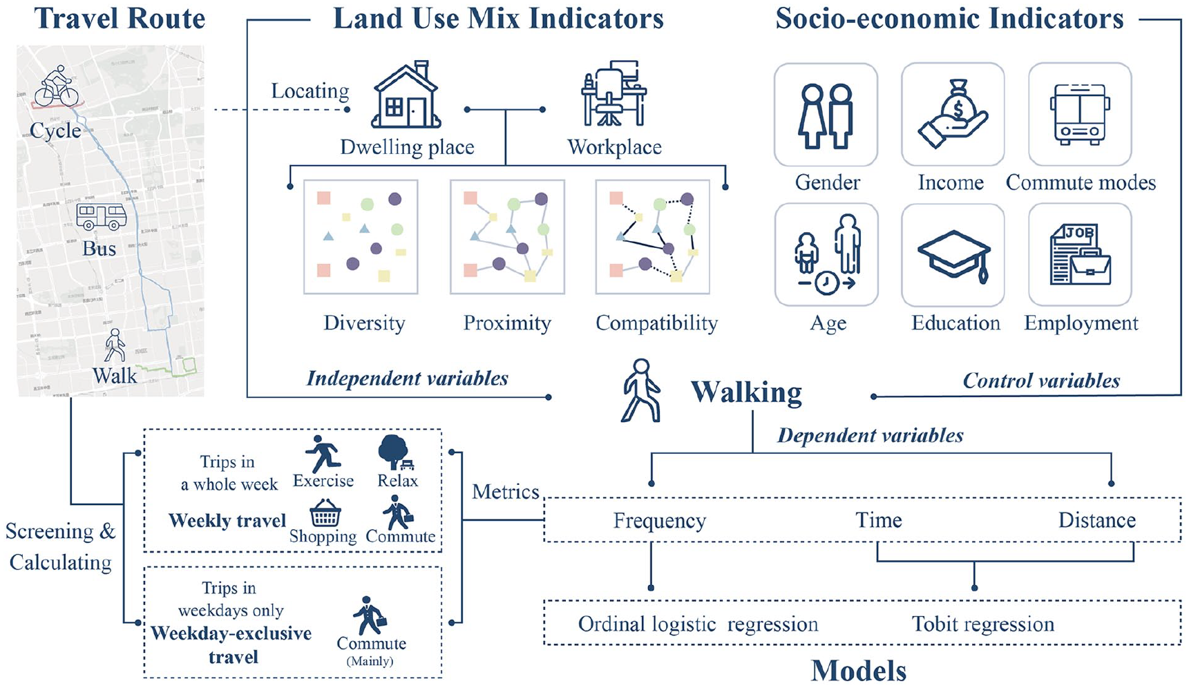
Research framework.
Various indicators for land use mix
Previous studies have confused meanings of LUM indicators (Hajna et al., 2014). As Chinese cities are highly mixed, the differences of land use mix may be more subtle and sensitive, so it is not comprehensive to measure LUM only by the Shannon entropy index (the most commonly used index in previous studies). A clearer definition and classification of LUM is thus required. According to the definition by U.S. Department of Transportation (www.transportation.gov/mission/health/land-use-mix), LUM is a 0–1 indicator that measures the mix of multiple land use types (such as office, retail, industrial, services, recreation, education, health, and public sector) within a given area. A score close to 1 indicates that there are a large number of blocks with different functions in a given area, with easy access to a variety of jobs and services.
LUM indicators can therefore generally be divided into three dimensions (Song et al., 2013; Zheng, 2018): quantity, distance, and function. In terms of quantity, the Shannon entropy index is often used to emphasize the richness and evenness of land use types within a certain range (Zheng, 2018). Other indicators in same dimension are Simpson’s diversity index and the balance index (Van Eck and Koomen, 2008; Song et al., 2013). However, the limitation of the Shannon entropy index is its inability to portray the spatial arrangement and relative significance of distinct land types. In instances where the proportion of residential, commercial, and public service land remains constant within a specific area, the Shannon entropy index would yield identical values (Hajna et al., 2014). However, close integration or dispersed layouts of these three land types may have different impact on walking behaviors. Furthermore, the Shannon entropy index fails to discern different functions of land use types, as it employs a uniform calculation approach for all land use types. In terms of distance, Euclidean distance and walk scores (Abdullahi et al., 2015; Hall and Ram, 2018) are developed to calculate accessibility or proximity, which could weigh up the level of convenience for residents to head for various destinations. Then, regarding the function aspect, the mixed degrees index can effectively and quantitatively measure the compatibility of land use types, which can more intuitively depict the mix of function (Tian et al., 2017). The mix of residential, workplace, commercial, and service land is widely believed to promote walking (Li et al., 2020), whereas those less related to daily travel may dilute the presence of important terminals, such as shopping malls or parks (Duncan et al., 2010).
This study will adopt the Shannon entropy index to describe the mix in quantity, take the walk scores to depict the mix in distance, and quantify the mixed degrees index for the mixed function. Generally, these three indicators summarize the widely used built environment factors to a large extent. Among them, the Shannon entropy index follows the diversity in 5Ds. The proximity of LUM comprehensively reflects the accessibility of various urban facilities (including public transport stations) and takes into account street characteristics, that is, being modified by the intersection density. In addition, the mixed degrees index is applied in the LUM-walking study for the first time. We emphasize the compatibility and exclusion of different functions.
Diverse indicators for walking
The existing literature has measured walking in different ways, such as frequency, time, distance, and mode selection (Sallis et al., 2004; Wu et al., 2021). However, the links between LUM and various walking metrics were inconsistent. Although studies find that mixed land use types can boost the travel frequency of residents, the total travel distance tends to drop due to the compact destination layout (Cervero, 1996). Correspondingly, the high-mixed community is generally held to be capable of facilitating the occurrence of walking, whereas no significance was found between LUM and travel time (Yin et al., 2020).
Obviously, under the goal of promoting public health of the population, individuals’ level of physical activity is closely related to the frequency, duration, and distance of active travel. Consequently, this study aims to concurrently scrutinize the relationship between LUM and walking frequency, duration, and distance. This approach facilitates a comprehensive comprehension of how identical LUM factors influence various indicators of walking behaviors.
Distinct geographical context and travel types
The purpose of travel, such as recreation, exercise, and commute, will affect residents’ travel behavior. The reasons why people head for a certain place may offset the perceived travel expenses (Jones, 1978), thereby changing the impact of the built environment on walking. Hence, in this study, we treat weekday travel and overall weekly travel as distinct entities, enabling us to examine the links of LUM-walking with different travel purposes. Although weekday travel does not entirely represent commuting behavior, we assume the majority of weekday travel corresponds to commuting activities. The dissimilarity between weekly travel and weekday-exclusive travel can be attributed to non-commuting activities during weekends.
Moreover, different geographical contexts may be tied to specific travel purposes (Ding et al., 2011). For example, in the vicinity of the dwelling place, daily activities, such as shopping, picking up children, or entertaining, can chiefly account for why residents prefer to walk in the community. Thus, proximity to shops, parks, or retail facilities is usually regarded as a feature that encourages walking (Guo and Loo, 2013). By contrast, the commercial facilities around the workplace may not affect the travel of commuters (Sarjala, 2019), as convenience is more critical than the abundant public services for active commuting (Mackenbach et al., 2016). Therefore, this research deems it imperative to examine the LUM around the dwelling place and the workplace separately.
Data and methods
Study area
Our study area is located in Beijing, a typical high-mixed city with high density in China. By the end of 2019, the permanent resident population of Beijing was 21.536 million, with land area reaching 16,411 km2 and the urbanization rate surging to 86.6%. Since the 1990s, the main built-up areas of Beijing have been extending in a circular pattern, gradually forming a polycentric urban spatial structure. The wave of urbanization and suburban urbanization has brought remarkable changes to residents’ travel modes. According to the fifth comprehensive traffic survey of Beijing, the number of private cars in the city was 4.197 million at the end of 2014, an increase of 630,000 compared with 2010, while the cycle mode share gradually fell from 62.7% in 1986 to 11.3% in 2014 (Beijing Transport Institute, 2017).
The data were selected from Shangdi Community and Qinghe Community in Haidian District, Beijing (see Figure 2), where they have recently created a new residential and job center, 16 km away from the downtown.
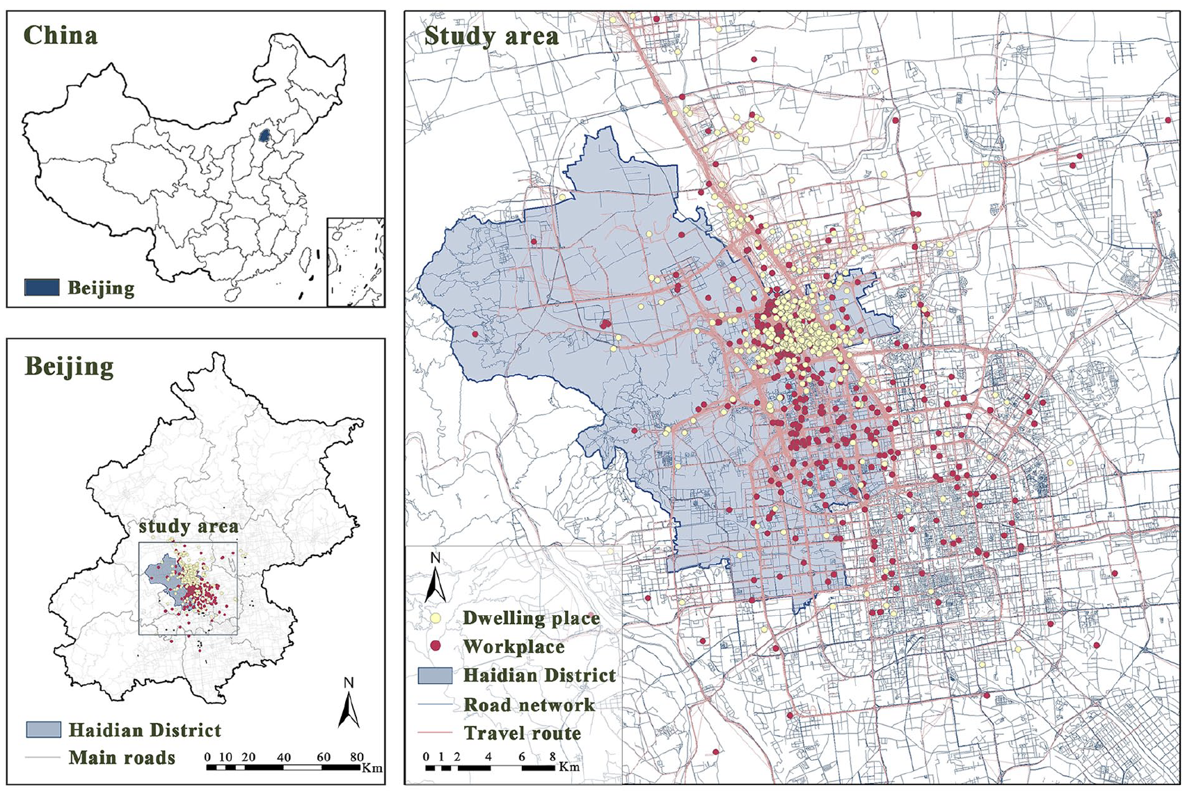
Study area.
Resident travel survey information
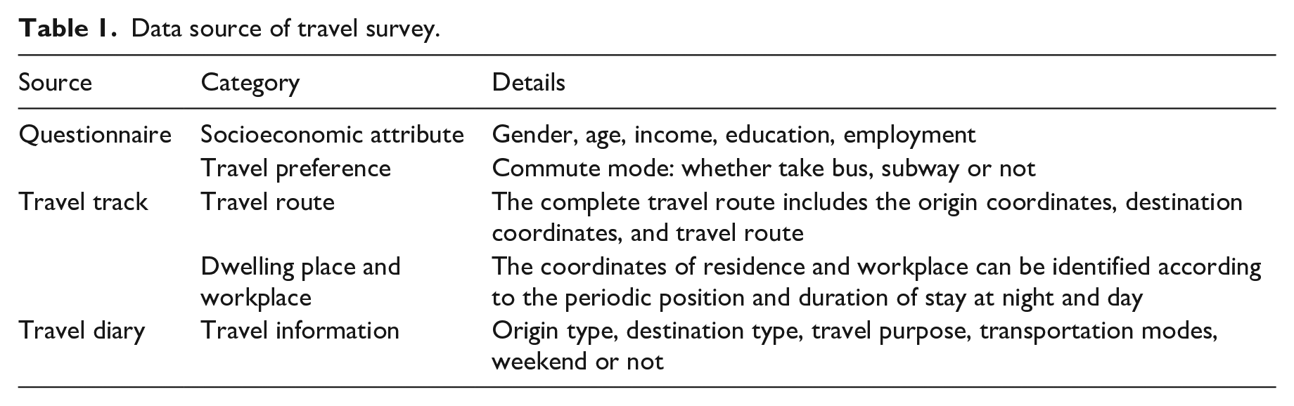
The travel survey was conducted from October to December 2012 in Shangdi and Qinghe communities, Haidian District, Beijing. The survey team adopted the PPS (Probability Proportionate to Size) sampling survey method, which means the sampling probability depends on community/firm size. Then we recruited the same number of respondents from the 24 communities and 22 firms selected. The survey can be divided into three parts: questionnaire, travel track, and travel diary. See Table 1 for the data and details that can be extracted. First of all, the participants need to fill in a questionnaire that contains basic personal information and their travel preferences. Second, they were required to wear a wristband with a built-in GPS tracking system in their daily life. During the one-week travel survey, the wristband records spatial coordinates every 30 sec and uploads the data every 5 min. Finally, the travel diary asked respondents to record some specific information, including start time and end time of each travel, destination type, and transportation modes. It is noteworthy that each respondent could accumulate multiple travel records within a week, including diverse modes such as walking, public transportation, cycling, and motor vehicle travel. Our analysis exclusively focused on walking records and calculated the total frequency, time, and distance of walking per individual within the workdays or the whole week. Besides this, according to the periodic location and duration of stay both night and day, we could identify the coordinates of their residence and workplace.
Data source of travel survey.
In this study, a total of 43,997 original sample travel records with multiple transportation modes were collected. The data cleaning finally resulted in 6329 records of walking from 664 individuals. According to Beijing Statistical Yearbook 2015 (http://tjj.beijing.gov.cn/), 23.7% of the permanent residents held at least a bachelor’s degree, and 53.8% of the population had stable jobs. However, due to response bias within the resident survey, our sample comprised a higher proportion of individuals with at least a bachelor’s degree (57.4%) and employment (90.2%), potentially introducing influence on results to some extent.
As not all respondents provided precise coordinates for their residence or workplace, we finally screened out 641 sets of coordinates for dwelling places and 600 sets for workplaces. The survey results demonstrate that the separation of residence and workplace is common among residents, as numerous people who work in the city center have to endure long commutes. The respondents live relatively concentrated in Shangdi-Qinghe Communities, whereas their workplace and travel routes are nearly all over the downtown area of Beijing. Precisely due to the convergence of dwelling place and the variation of workplace, this survey offers a unique perspective to study the relationship between LUM and walking.
Correcting for residential self-selection
Over the past two decades, the possible confounding effects of residential self-selection (RSS) on the influence of the built environment on walking have gained much attention (Ewing and Cervero, 2010). The key issue is that if people select housing due to their own expectations, namely, when self-selection exists, people’s attitude rather than the neighborhood affects travel behavior. For example, individuals who enjoy walking may prefer to live in walking-friendly neighborhoods and walk more often. Under such circumstances, we may overestimate (Bohte et al., 2009) or underestimate (Yang et al., 2019) the influence of a built environment on walking, thus misleading the subsequent public policies.
Therefore, a growing number of studies have applied multiple strategies to address RSS, including (quasi-)longitudinal design, propensity score matching and structural equations (Cao and Fan, 2012; Wang and Lin, 2019). On the basis of the China’s unique contexts, this study mitigates the potential bias due to RSS by screening for specific housing types. The feasibility of this method has been verified in previous studies (Wu et al., 2021).
In the past, Danwei, a generic term denoting a work unit of any kind, including public institutions, party organs, government departments, military units, and state or collectively-owned enterprises in China (Wang and Chai, 2009), has existed as a dominant structural unit of Chinese urban built environment and society. Each Danwei is allocated some land, usually contiguous, thus providing employees with not only jobs but also housing and social services. Since the reform and opening up, China’s housing market has undergone a transformation from a welfare housing regime to a liberalized market. The transition has left cities with a complicated housing stock (Wang and Zhou, 2017). Altogether, Chinese cities now have two major sources of housing. One is the commodity housing traded in the market. The other is housing provided to specific groups at below market price, including reformed housing produced by the privatization of Danwei under the socialist welfare housing regime, resettlement housing built by the government in the process of urbanization, and affordable housing provided to middle- and low-income groups (Chen and Han, 2014). Evidently, the location of the latter depends on the land historically allocated to state-owned units or urban development plans, with a small self-selection effect.
Therefore, to mitigate the influence of RSS, residents who live in Danwei-reformed housing, affordable housing, or urban resettlement housing will be selected as subsamples with smaller endogeneity. This approach aims to minimize potential estimation biases associated with LUM-walking. Among them, 207 subsamples were selected from 641 residential samples, including 1874 walking records; 186 subsamples were obtained from 600 workplace samples, containing 1690 walking records.
LUM indicators
We adopt the Shannon entropy index to describe the mix in quantity, take the walk scores to depict the mix in distance, and quantify the mixed degrees index for mixed function. The calculation methods of these three indicators are as follows.
Shannon entropy index
The land classification data came from the second national land survey (published in 2013, with data collection spanning until December 31, 2009). We selected seven types of land, including residential, commercial and services, science and education, cultural and recreational, public facilities, park and green space, and transportation land, for which we calculated the Shannon entropy index in a 500 m and 1500 m buffer (representing the ranges of 5 min and 15 min walking, respectively) around the dwelling place and the workplace. The formula is
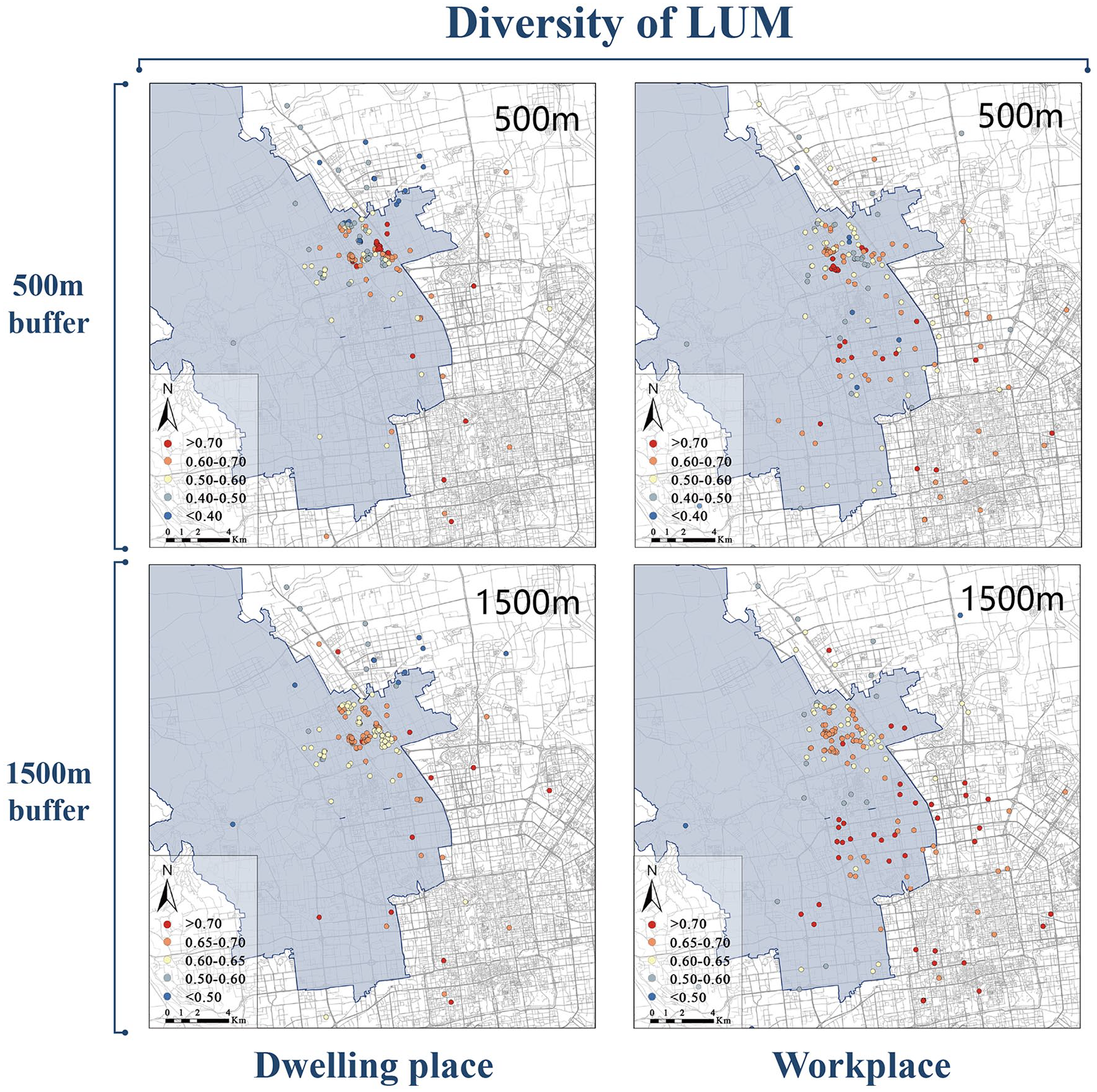
Distribution of diversity of LUM around the dwelling place and workplace.
Walk scores
Point of interest (POI) is obtained in 2015 by crawling the Baidu map through Python. Nine POIs, namely, leisure and entertainment, medical services, life services, education and training, shopping facilities, catering facilities, public facilities, banks, and public transportation stations, are unaffectedly chosen. We assigned scores according to the shortest distance from each type of POI to the starting point, the coordinates of the dwelling place or workplace. Consulting the calculation method shared by www.walkscore.com, a distance greater than or equal to 2000 m is scored as 0. The closer the distance, the higher the score, as the full score is 100. Then, the mean walk scores of the above nine POIs were applied to represent the proximity of LUM. We must emphasize that that the walk score itself does not represent distance. Instead, a higher walk score entails better access to the nearby amenities. Figure 4 presents the walk scores distribution.
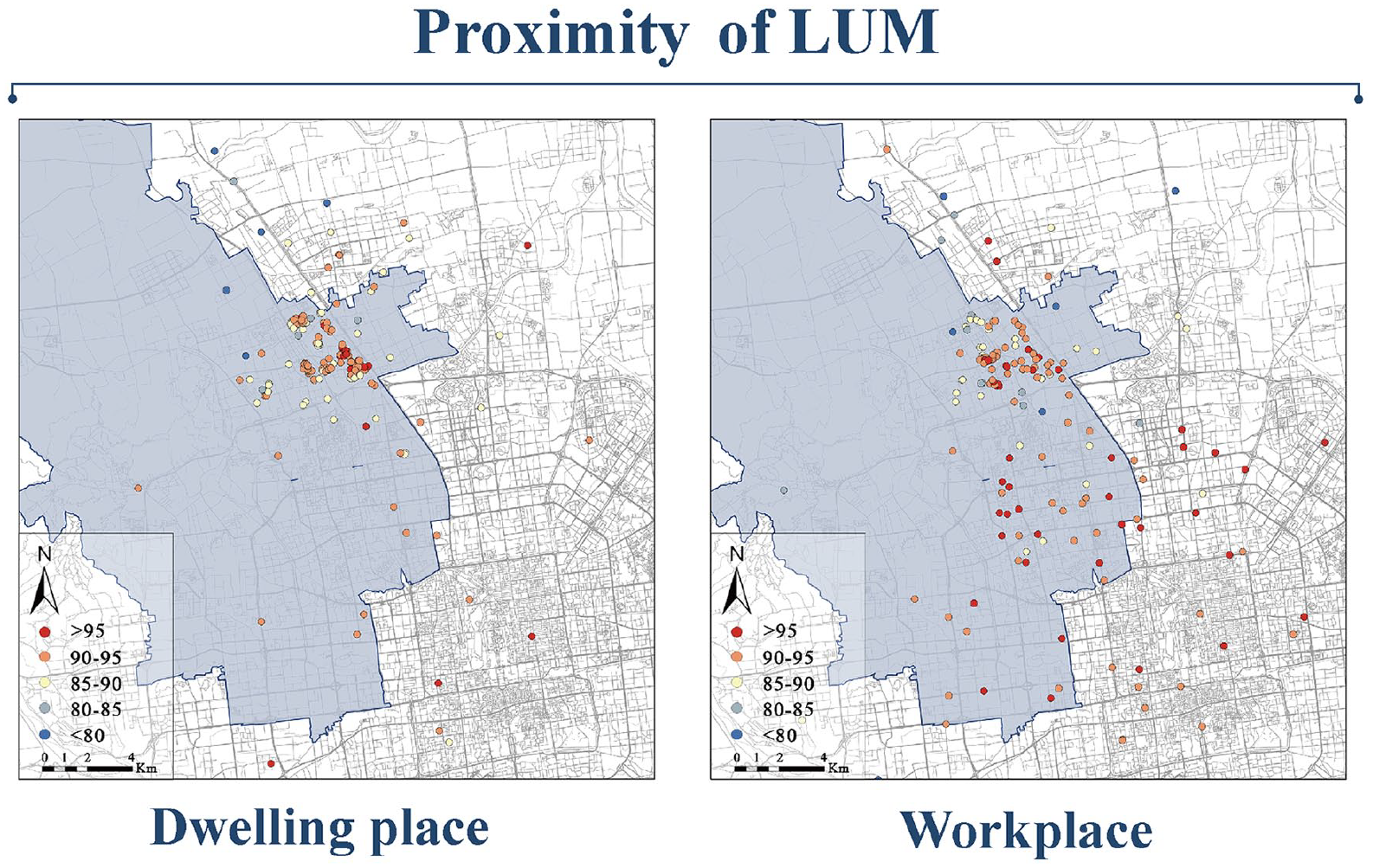
Distribution of proximity of LUM around the dwelling place and workplace.
Mixed degrees index
A 100m*100m grid is established in ArcGIS, which is the minimum spatial unit to meet the demands of function. The grid of the dwelling place and workplace is determined in accordance with the proximity. The main land use type of each cell is identified by the proportion of land use type in the grid. In this study, a compatibility comparison matrix of land use types was established (Supplement Table A2) with reference to (Tian et al., 2017; Zheng, 2018). For instance, residential and commercial land are considered compatible and assigned a value of “1”. Residential and transportation land are considered conditionally compatible, meriting a value of “2”. In contrast, residential land is deemed incompatible with mining land, thus assigned a value of “3”. The cell of dwelling place or workplace is regarded as the center in which basic value is designated as “1”. Eight neighboring cells are assigned values according to the compatibility comparison matrix, and all scores are added up to finally obtain the mixed degrees index of each spatial unit. Slight mix is based on a value of “1–4”, and medium mix is based on a value of “5–9”. A value greater than or equal to “10” is considered to be high mix. See Figure 5 for the distribution of MDI.
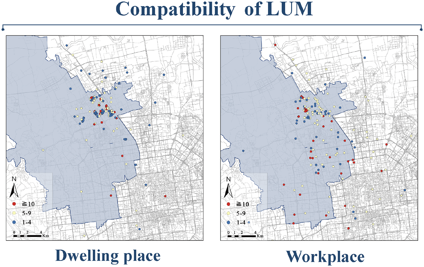
Distribution of compatibility of LUM around the dwelling place and workplace.
Models
The study used the frequency, time, and distance of walking as dependent variables, which are calculated for the whole week (weekly travel) and on workdays (weekday-exclusive travel). It is imperative to clarify that we did not directly compute two-day travel patterns on weekends, due to the limited number of walking records during weekends. Additionally, each participant only reported their weekend travel for a specific week, possibly influenced by chance occurrences. To discern shared patterns, we opted to aggregate data for the entire week. We assumed that travel during workdays is mainly for commuting, while weekly travel may cover leisure on weekends (Wu et al., 2021).
The independent variables were calculated using the individual’s residential and workplace as the fundamental units of analysis, while the dependent variables were not counted based on residence and workplace. Meanwhile, diversity, proximity, and compatibility of LUM were separately incorporated in the model to exclude the interference of collinearity. Moreover, a range of individual and socioeconomic attributes were controlled for, including gender, age, income, education, commute mode, and employment. Given that more than 10% of the interviewees did not report walking within a week, resulting in an increased frequency of zeros in the dependent variable, we opted for statistical models tailored to accommodate this data distribution. Specifically, we employed the ordinal logistic regression model to analyze walking frequency, while the Tobit regression model was selected for investigating walking time and walking distance. The non-zero parts were regulated by logarithmic transformation to meet the requirements of normal distribution. For all models, standard errors were clustered at the level of communities or firms. Descriptive information of each variable is shown in Table 2.
Description of model variables.
Results
The results of the subsamples are shown in the table below. Only the smaller yet less endogenous samples with the predetermined residential location have been used. The results of the full sample are presented in the online appendix. By comparing the regression results of the full sample and subsamples, we can further confirm effect robustness and reveal the loss in statistical power through the change of sample size on the one hand and observe the influence of RSS on the correlations on the other hand.
Correlation between LUM and the frequency of walking
Tables 3 and 4 show the results of the ordinal logistic regression models with the frequency of walking as the dependent variable. At the home end, the diversity of LUM is only related to the commute. A higher diversity entails a lower probability of residents walking at high frequency on weekdays. Moreover, its association weakens when the buffer zone is enlarged (500 m buffer: OR = 0.111 < 1; 1500 m buffer: OR = 0.014 < 1). However, the proximity of LUM is always positively correlated with the walking frequency around the workplace (All travel: OR = 1.061 > 1; Commute: OR = 1.060 > 1). No significant effect is identified on walking frequency by the compatibility of LUM, either around the home or the workplace.
Subsample correlation of LUM and frequency of walking around dwelling place.
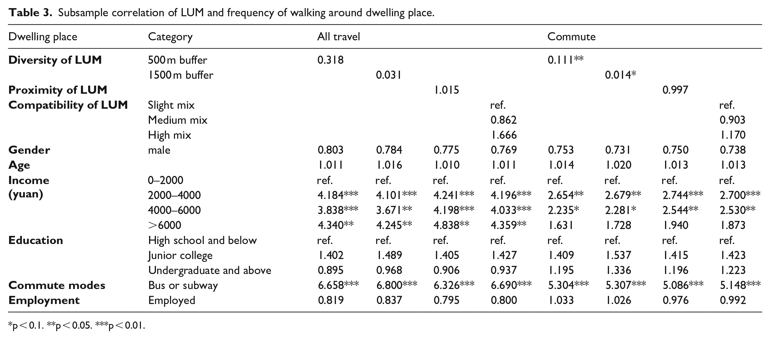
p < 0.1. **p < 0.05. ***p < 0.01.
Subsample correlation of LUM and frequency of walking around workplace.
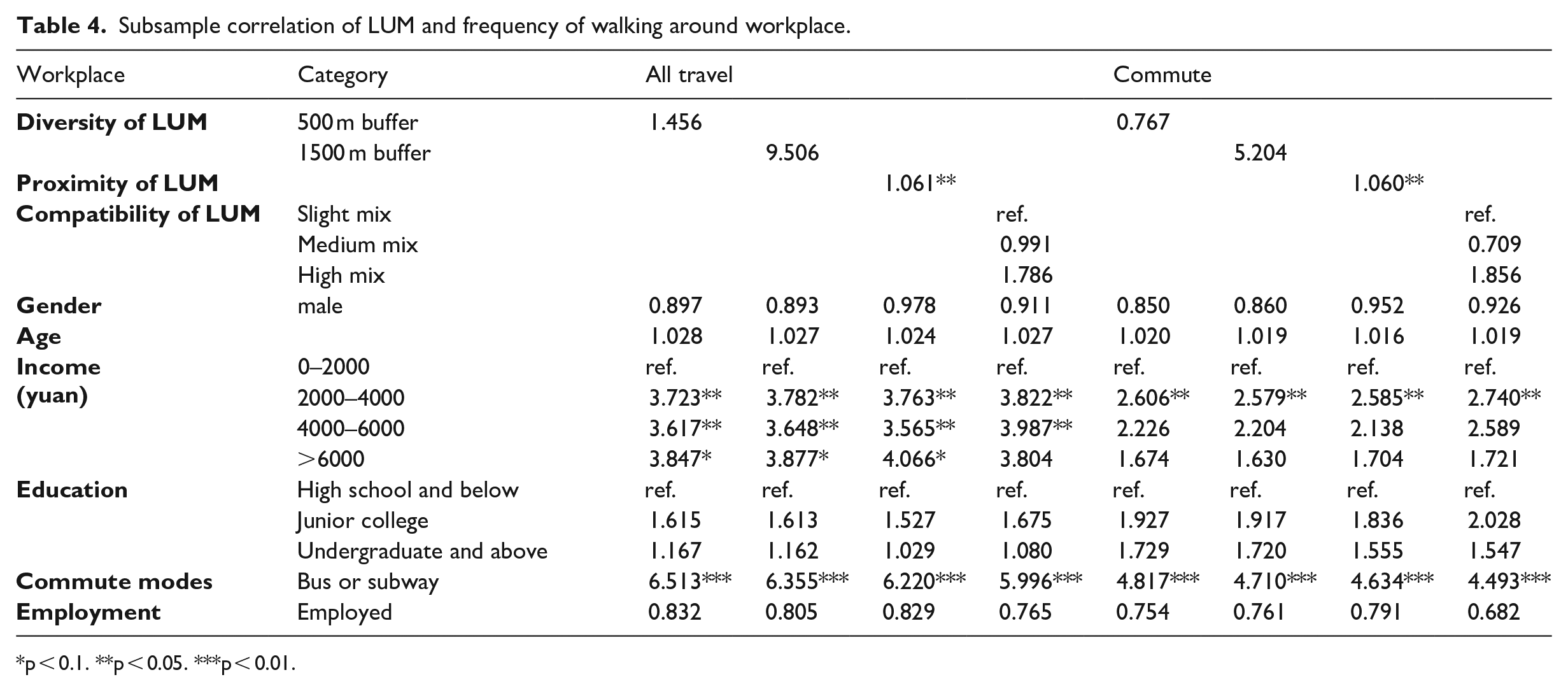
p < 0.1. **p < 0.05. ***p < 0.01.
Among the control variables, income and commute modes strongly influence the walking frequency. Compared with low-income groups, people with a higher monthly income walk more often, especially during non-commute hours. However, when the commute travel is considered solely, people making more than 6000 yuan per month are no longer inclined to walk due to their high possibility of car ownership. In addition, those who take the bus or the subway for their daily commute are more likely to walk.
Compared with the full samples’ multivariate correlations (Supplement Tables A3 and A4), the estimated effect of diversity on the walking frequency around the dwelling place shows consistency between the two sets of results, except with some loss of statistical significance in the subsample estimates due to sample size reduction. Similarly, the negative correlation between home-end proximity and active commute frequency disappears in the subsample, and so does the high-mix land use’s positive correlation with walking frequency around the workplace. However, some differences may not be attributed to sample size, that is, the results in the smaller subsample are either opposite in sign or more significant statistically. In addition, they may indicate the influence of endogenous variables. For instance, around the workplace, proximity’s effect on walking frequency turns from insignificant in the full sample to positive in the subsample. With regard to the control variables, the full sample’s results show that the walking frequency of residents will decrease with the growth of age, which is in line with the hypothesis that the elderly will reduce their walking frequency due to physical decline.
Correlation between LUM and the time of walking
Tables 5 and 6 show the Tobit model results, with the natural logarithm value of walking time as the dependent variable. The Tobit model applies to constrained dependent variables, which are distributed roughly continuously on positive values but contain a subset of observations of zero with positive probabilities. In addition, the table records the average marginal effect of the core variable on the dependent variable when y > 0. The Marginal Effect (ME) typically represents the alteration in the dependent variable resulting from a one-unit shift in the explanatory variable (Liu et al., 2017). In the present study, since the dependent variable is processed with natural logarithms, a one-unit alteration in the independent variable corresponds to a (ME*100) % change in the dependent variable.
Subsample correlation of LUM and the natural logarithm of walking time around dwelling place.
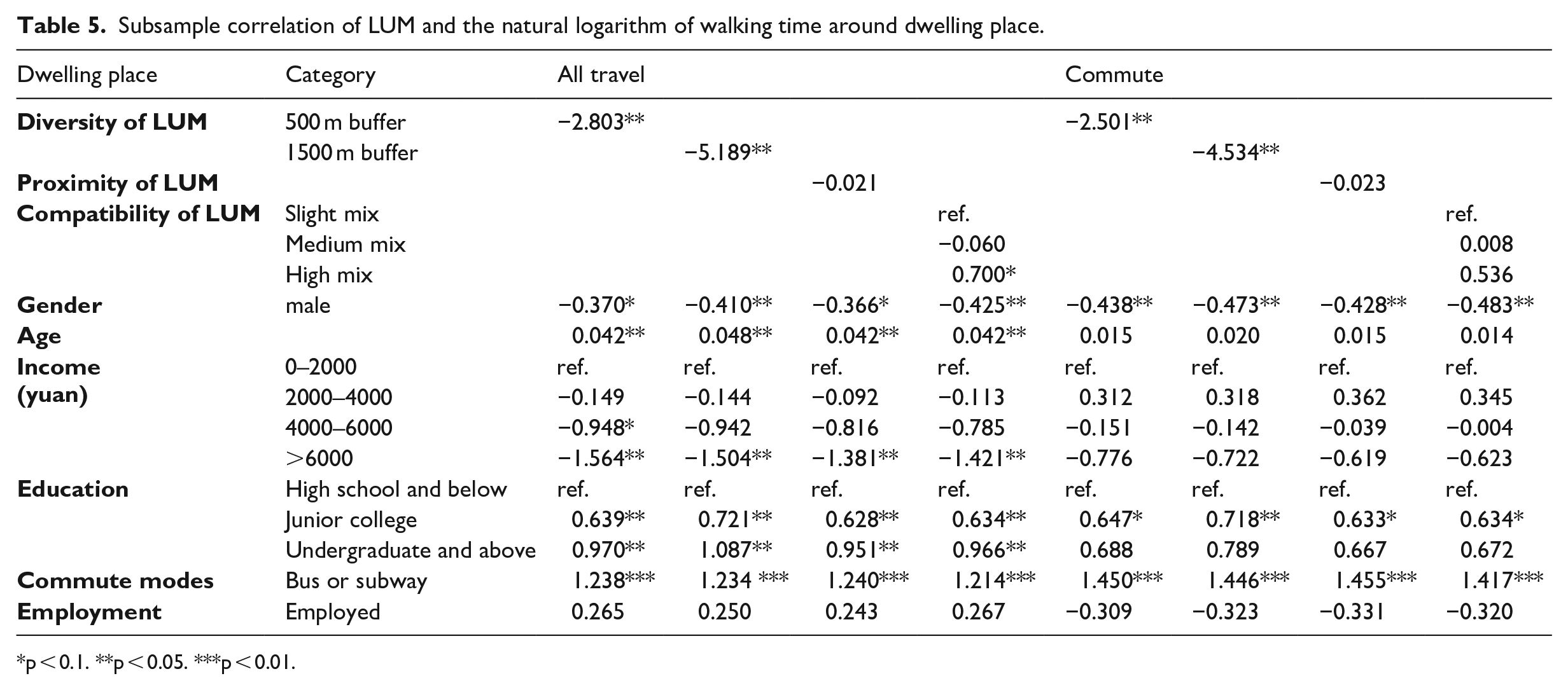
p < 0.1. **p < 0.05. ***p < 0.01.
Subsample correlation of LUM and the natural logarithm of walking time around workplace.
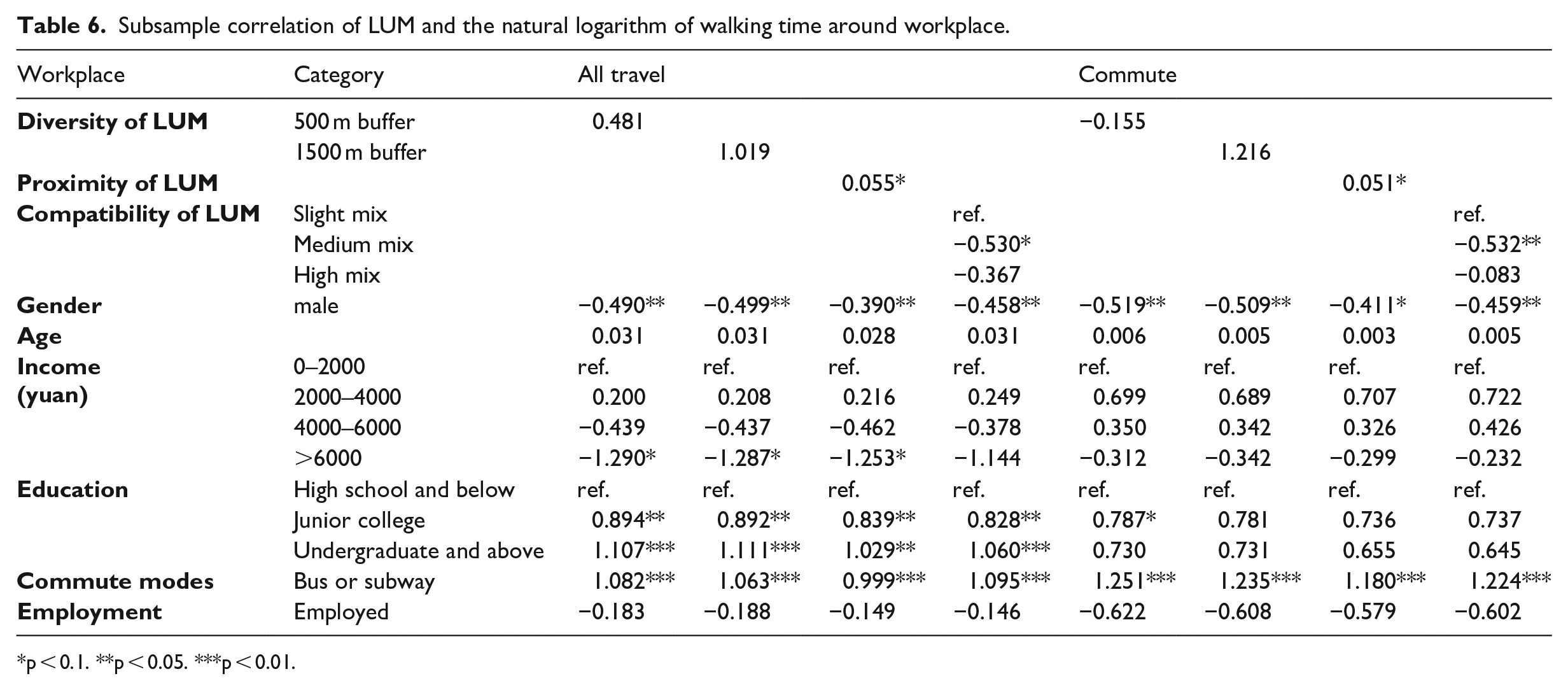
p < 0.1. **p < 0.05. ***p < 0.01.
In terms of samples in the dwelling place, the diversity is always negatively correlated with the walking time. In addition, a high functional mix of land use cultivates residents’ weekly walking time by an average of 70.0% compared with a slight functional mix. As for the workplace, weekly walking time and commute walking time increase by 5.5% and 5.1%, respectively, on average for each increment in the proximity of LUM. Surprisingly, moderate functional mix of land use near the workplace results in less walking time than slight mix.
Gender, age, income, education, and commute mode all show statistical significance on walking time. Generally, men will have less walking time than women. Older people are likely to walk longer. Higher levels of education greatly increase individuals’ walking time in leisure time, while people with higher income have less walking time. Groups that take buses and subways for their daily commutes will walk longer.
Some factors’ correlations with walking time remain the same compared with the full samples’ multivariate correlations (Supplement Tables A5 and A6), such as home-end diversity and job-end proximity. For compatibility indicators, the positive effect of moderate mix land use around the residence on walking time disappears in the subsample, whereas the effect of high-mix land use around the workplace changes from insignificant in the full sample to negative in the subsample. Similar differences occur in the control variables, such as age and income, which are not significant in the whole sample but are significant in the subsample.
Correlation between LUM and the distance of walking
Tables 7 and 8 also exhibit the Tobit model results, with the natural logarithm value of walking distance as the dependent variable. Around the dwelling place, a higher diversity of LUM entails a shorter walking distance of residents. The individuals’ weekly walking distance under high mix land use will increase by 34.9% on average compared to slight mix land use. In the vicinity of the workplace, proximity is positively correlated with walking distance. Meanwhile, compatibility is negatively linked. The average weekly walking distance and commuting distance will be reduced by 27.4% and 27.8% when the land use around the workplace is moderately mixed compared with slightly mixed. In addition, the effects of gender, age, income, education, and commute modes on walking distance are consistent with those on walking time.
Subsample correlation of LUM and the natural logarithm of walking distance around dwelling place.
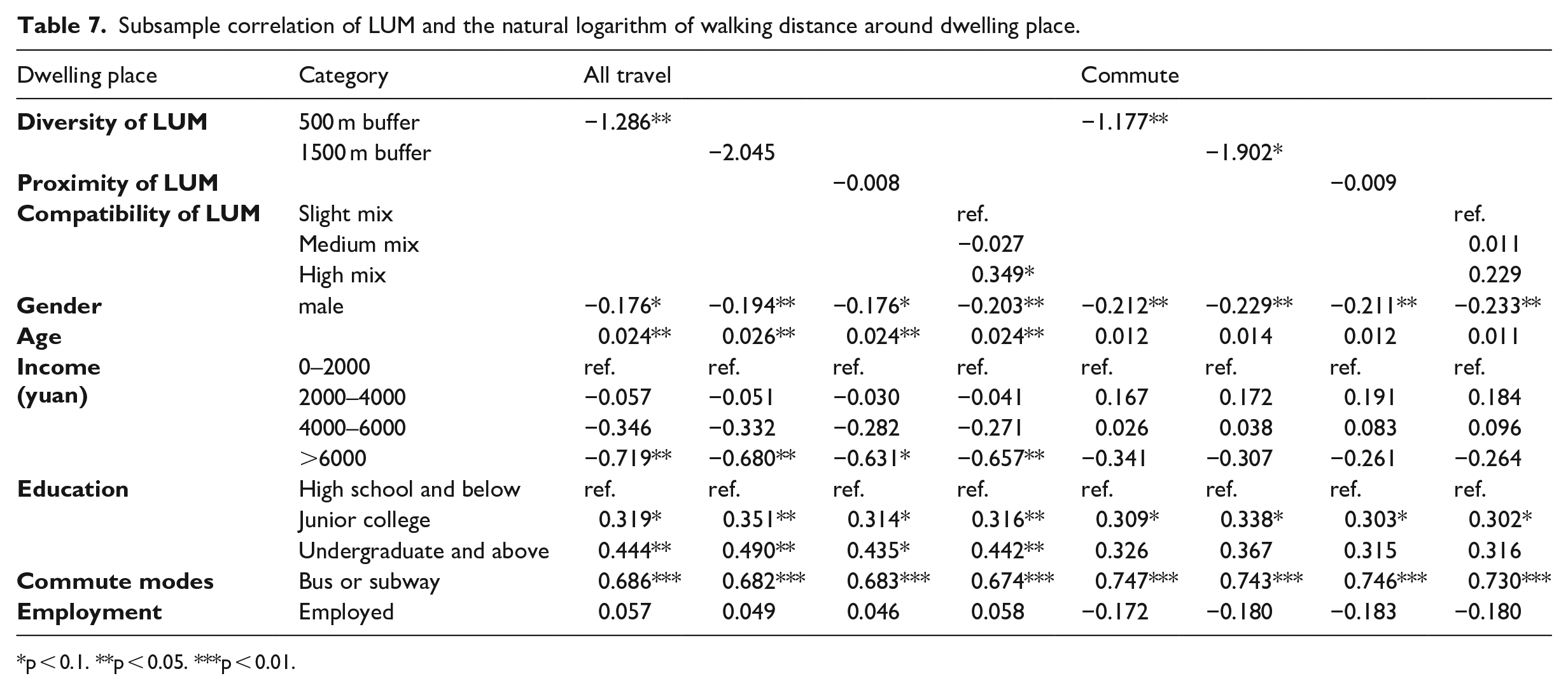
p < 0.1. **p < 0.05. ***p < 0.01.
Subsample correlation of LUM and the natural logarithm of walking distance around workplace.
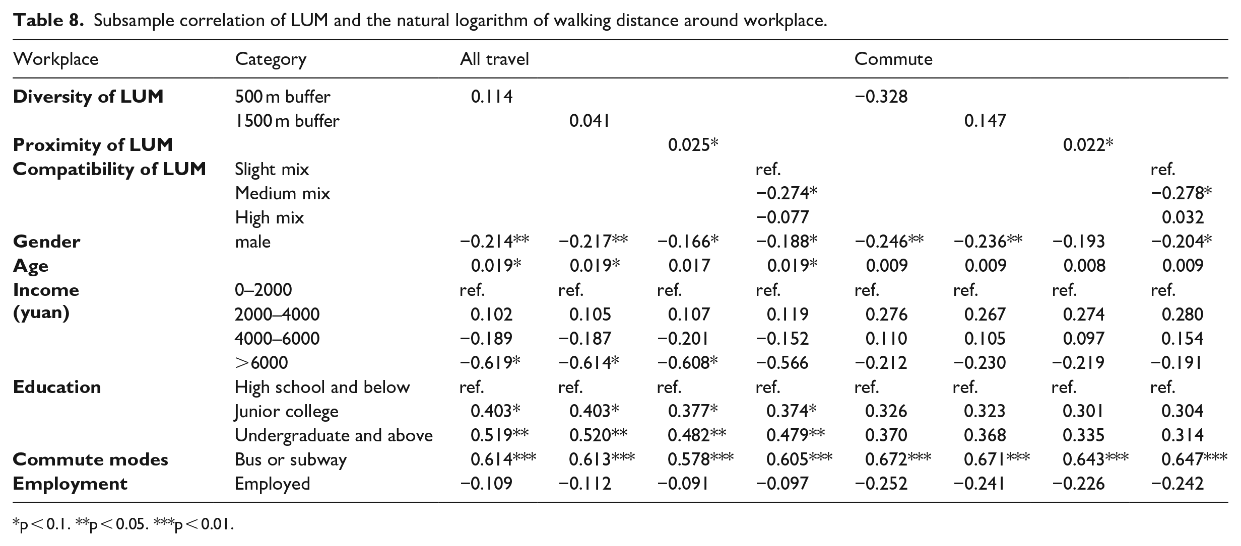
p < 0.1. **p < 0.05. ***p < 0.01.
In the full sample (Supplement Tables A7 and A8), land use diversity within the 500 m buffer around the residence is negatively correlated with the walking distance. On the job end, only the proximity’s effect on the walking distance remains significantly positive. Moreover, the ways in which all kinds of factors affect the walking time or distance are basically similar.
Model summary
We summarize the model results of all subsamples to Table 9 and obtain some interesting findings after comparing them.
Model summary of subsamples.
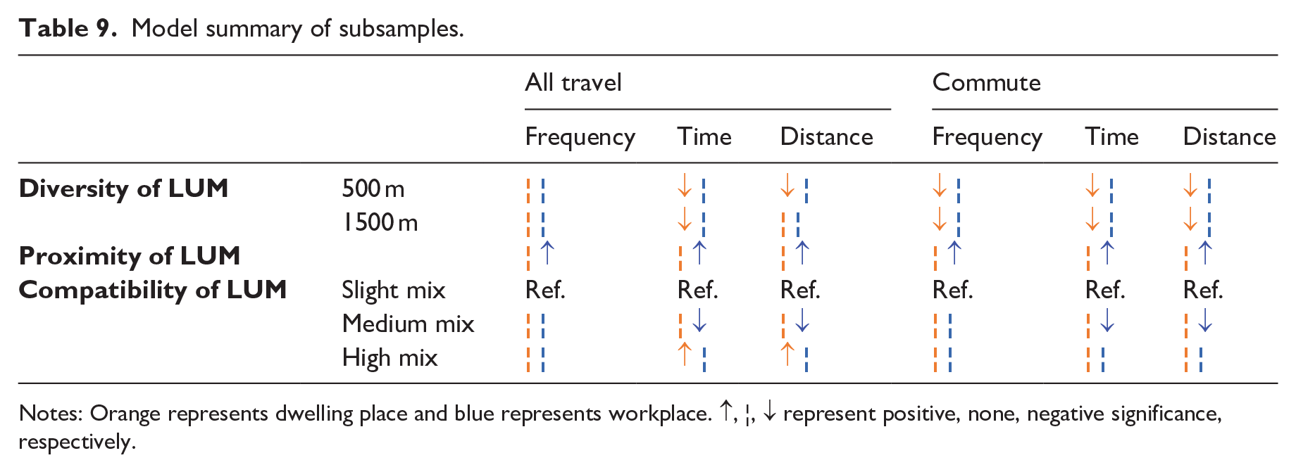
Notes: Orange represents dwelling place and blue represents workplace. ↑, ¦, ↓ represent positive, none, negative significance, respectively.
First, different LUM indicators have a complex impact on walking behaviors. For example, land use diversity is negatively correlated with walking metrics around the residence, while land use proximity shows a positive correlation only around the workplace. In addition, the moderate mix of land-use functions is not conducive to the walking time and distance in any time period, whereas high mix of land-use functions is able to increase the weekly walking time and distance.
Second, the time and distance of walking respond to changes in the built environment or individual attributes in a basically similar way but different from walking frequency. Specifically, the diversity and compatibility of LUM show significant associations with walking time and distance. However, they are not associated with walking frequency. Gender, age, and education level do not affect the frequency of walking. However, they affect the time and distance of walking. Income increases the walking frequency but decreases the time and distance.
Third, differences exist between the results of all travel and commute, which indicates that residents’ walking behavior and preference will differ with the change of travel purpose. For instance, higher diversity of land use around the residence entails a lower frequency of commute walking. However, diversity does not seem to affect travel on weekends. The positive effects of functional land use mix on walking time and distance appear to promote walking on weekends, while they have nothing to do with commute tours. Moreover, the results of control variables show that those who take the bus and the subway on their daily commute always have higher frequency, time, and distance of walking.
Discussion
Diversity of LUM vs. proximity of LUM vs. compatibility of LUM
The existing research generally agrees that mixed land use types could provide a greater variety of destinations within a shorter travel distance, thus increasing residents’ likelihood to walk (Boarnet and Crane, 2001). This interpretation implies many aspects of LUM, namely, diverse destinations, shorter distances, and rich functions. In this study, the diversity, proximity, and compatibility of LUM are all taken into account, which have various effects on walking behavior.
Contrary to most previous studies (Cervero, 1996; Ewing and Cervero, 2010), this study remarkably found that greater land use diversity is associated with reduced total weekly walking time and distance within the 500-meter buffer zone around the dwelling place, and this correlation diminishes within the 1500-meter buffer. Specifically, when analyzing weekday travel exclusively, an increase in land use diversity correlates with a decrease in walking frequency. This phenomenon may have two possible explanations. First, a greater deal of land use types is by no means tied to a further variety of destinations, as not all of the land use types can encourage walking. Visibly, the mix of residential and commercial land use types not only facilitates residents’ social life to promote walking but also stimulates the long-term vitality of commercial areas (Song et al., 2013). Meanwhile, the same quantity of residential and transportation land mixture may enhance the proportion of vehicle travel due to the improvement of connectivity (Ewing et al., 2011). Second, large-scale commercial property serves the residents (especially for commuters) with one-stop services (Cheng et al., 2019), such as shopping, entertaining, etc. so that they can achieve all purposes with only one trip per week but with reduced frequency of walking. To align with their available time, individuals with demanding work schedules often engage in maintenance shopping on optimal days (Nordfalt, 2009), such as buying necessities for the upcoming week during weekends or opting for food delivery services (Oostenbach et al., 2023). Therefore, the integrated, one-stop, and all-customer shopping center or commercial complex satisfies the needs of residents, which may usher the transition from making multiple, separate trips to chaining these trips into one tour. Moreover, the wholesale shopping market may also reduce the frequency of trips for shopping in a week, as its goods are always with large quantity and low price (Cadilhon et al., 2003).
The effects of land use proximity are in line with expectations: the nearer the distance, the more likely it is to boost walking. As has been verified by existing studies, when the residence is closer to destinations, such as city centers, commercial facilities, public transportation stations, green space (Cheng et al., 2019; Næss, 2013; Vich et al., 2019), and so on, residents would drive less and have less reliance on vehicles, thereby encouraging the possibility of walking. Evidently, people’s willingness to travel also follows the theory of distance decay (Næss, 2013), that is, for those facilities or places that are tightly bound to daily life, residents always tend to opt for those closer with similar destination quality. Interestingly, proximity promotes walking only in the vicinity of the workplace but not around the residence. This observation may imply that trips around the workplace are more likely to be influenced by efficiency, which seems to be more important than the abundance of public facilities (Mackenbach et al., 2016).
Some interesting insights into how LUM might modify walking can be drawn. Despite Western countries in the 20th century attempting to increase efficiency and security by separating incompatible land uses (Hoppenbrouwer and Louw, 2005), in decades of experience, such single functional zoning, namely, slight mix of land use types in this study, has caused problems, such as workplace-residence separation, regional congestion, and loss of urban vitality (Herndon, 2011). Conversely, moderate mix represents a certain degree of functional diversity with compatible mixed land use types, which verify the results of previous studies that functional mixed land uses can reduce the time and distance of each trip (Feng et al., 2013). This notion also coincides with the current planning concept that the mix of diverse uses can create vibrant and successful neighborhoods (Fuller and Moore, 2017). However, high mix of function, although contributing to extended walking duration and distance, does not correlate with increased walking frequency, which may not inherently indicate a positive outcome. If there is an evident exclusion of adjacent land such as the mix of residential and industrial land leading to negative externality like noise and pollution (Bogale et al., 2022), residents might be compelled to go to a farther place for exercise (Næss, 2013). In addition, we found that the residential self-selection phenomenon is more likely to affect compatibility. In other words, if residents have a preference for housing or workplace, they care more about whether the surrounding functions meet their needs rather than the distance or density of diverse facilities.
Travel modes vs. physical activity
As more frequent walking indicates a lower proportion of vehicle travel, walking frequency implies the choice of travel modes (Wu et al., 2021). It is regarded as an important policy parameter to achieve the target of intervention, such as alleviating traffic congestion, improving air pollution, and mitigating climate change (Krizek et al., 2009; Woodcock et al., 2007). Moreover, walking time and distance are commonly used to measure individual physical activity levels, which are also defined as the policy parameters to intervene in residents’ physical and mental health (Omorou et al., 2020). Notably, these two types of indicators do not respond in the same way to variations in the built environment. The impact of LUM on walking time and distance tend to be consistent but generally not in line with walking frequency.
A longer walking time with a longer walking distance may imply two interpretations. First, the increase in frequency leads to an increase in the total walking volume (Cheng et al., 2019). Second, although the frequency stays the same, the walking time and distance rise, as the destination is located farther. In this study, how land use proximity around workplace affects walking behaviors belongs to the former, which encourages people to choose to walk and creates more physical activity. However, around the residence, the impact of high mix land uses on walking behavior is more likely to be the latter, which demonstrates that the negative externality generated by high mix probably affects residents’ travel choices (Tian et al., 2017). Compared to the nearer activity space, residents are more willing to select those that are better but farther.
Groups earning more than 6000 yuan a month will walk more frequently with less walking time and distance. This circumstance appears to match user characteristics of high-income groups, who are expected to visit comprehensive shopping malls to experience one-stop service. In contrast, women and the elderly walk longer and farther, which is consistent with the family responsibility hypothesis (DiSantis et al., 2016). Such daily routine would not change the walking frequency. As for highly educated people, they walk longer and farther in hopes of improving their physical fitness through exercise.
However, the question now is: can different policy goals (e.g., reducing congestion and promoting health) associated with encouraging walking be achieved simultaneously by a specific built environment intervention (Wu et al., 2021)? We suggest that solutions may be found from the following two perspectives. First, although LUM may reduce the duration and distance of each trip, creating a more convenient, time-saving, and continuously attractive walking environment may encourage residents to walk more often (Næss, 2013) and help them achieve recommended levels of physical activity in total. Second, even if the frequency of walking cannot be increased directly, longer and farther walking can be motivated under the condition that the LUM is compatible. Some suggestions include adding sports complexes or gyms to one-stop services and enhancing residents’ awareness of exercise through the popularization of science.
Recreational travel vs. commute
Some built environment-walking studies have realized that how the environment affects walking is related to travel purposes (Ding et al., 2011). Therefore, land use policies seem to be modified with different travel purposes. Among them, utilitarian-oriented commute and recreational trips, which are primarily about the travel experience, are evidently different. Our results confirm the views of previous studies that utilitarian walking is more affected by proximity to destinations, connectivity, and mix, whereas recreational walking is more related to the quality (Giles-Corti et al., 2013). Specifically, travel behaviors around the workplace have a strong response to the land use proximity, while moderately mixed functional land reduces commuting time and distance. Apparently, commute is more subject to the objective constraints, such as time and money, rather than individual intentions; thus, efficiency comes first (Mackenbach et al., 2016). In contrast, recreational travel is more affected by personal will. In other words, the freshness, security, and good experience that may be brought by travel environment will become an attraction to encourage leisure walking. Our study found that only when travel over the weekend is considered does functional mix of land show a positive effect on walking time and distance. This condition also confirms the hypothesis that residents may opt for farther but better-quality environments for physical exercise, and, in the process, the strong desire to travel to a certain place is sufficient to offset the cost of travel (Jones, 1978). Similarly, the significant links between individual socioeconomic attributes and walking are greater in the full sample, thus suggesting that people will walk more aside from commuting, which is much related to their personal habits and social environment. For example, older people are accustomed to walking, exercising, and participating in neighborhood socializing (Cheng et al., 2019). The appropriate land use planning can help to create a more intimate environment for social relations, thus producing an opportunity to alleviate social exclusion and increase the subjective well-being of the elderly (Li et al., 2020).
When it comes to commute, jobs–housing balance is generally deemed to be a powerful influencing factor in encouraging walking (Ewing and Cervero, 2010). In this study, the residences of respondents are mainly located in the Fifth Ring Road of Beijing, whereas the workplaces are mostly concentrated in the city center with high density. Hence, the separation of workplace and residence still exists in Beijing. Since the 1980s, many Chinese cities have undergone a dramatic expansion of their built-up areas, suburbanization, and spatial transformation (Wang and Zhou, 2017). Planners make an effort to relieve the pressure of the central built-up area by an outward movement of population and jobs from the city center to the suburbs. However, the reality is that suburban clusters fail to develop independently but are absorbed by the central built-up area, thus forming a circle structure with a Chinese nickname “TanDaBing” (Yang et al., 2012). Central areas remain the best-equipped parts of the city, with relatively poor population groups migrating to the suburbs. The process of moving to the suburbs leads to fewer jobs and longer commutes. However, living near transportation facilities can effectively reduce travel costs, thus making it a popular choice for commuters (Cervero and Day, 2008). In fact, many studies on commuting behavior confirm that the number of bus stops and bike stops has a positive effect on walking (Ewing and Cervero, 2010). This study also found that people who choose buses and subways for daily commute are always highly related to walking. However, our study highlights that public transport-oriented planning can not only ease congestion and reduce environmental pollution in urban centers but also provide walking or cycling opportunities to and from stations; thus, the levels of physical activity are increased (Cheng et al., 2019).
Conclusion
This study examines the links of LUM-walking under a comprehensive framework in China. It emphasizes that diverse LUM indicators affect walking in different ways and that a various different walking metrics may lead to contradictory policies. Moreover, trips for different purposes may be affected by multiple factors. In addition, we take advantage of the unique institutional context of China’s urban housing market to observe the residential self-selection.
In general, this study states the following findings. Firstly, proximity of LUM stands as the sole environmental factor driving an increase in walking frequency. While the mix in quantity and function implies the provisioning of diverse services within a specific radius, thus enhancing convenience for residents, it might also incline residents to link multiple trips into one, thereby potentially reducing walking frequency. Secondly, while the positive impact of mixed land use on promoting walking to replace motor vehicle travel holds true, there are instances where varied and convenient travel environments could lead to shortened walking distance and duration. Such a scenario might not align favorably with public health considerations. Conversely, in other cases, although residents increase their walking duration and distance, it might be a compensatory behavior aimed at avoiding the negative externalities stemming from high functional mix. Thirdly, on weekdays, most trips tend to prioritize practicality and efficiency, whereas weekend leisure travel are more influenced by personal preferences. Moreover, encouraging the use of public transport facilities during daily commutes not only alleviates traffic problems caused by jobs–housing separation, but also promotes walking behavior as people move between stations.
We acknowledge that the data used in this study are from about a decade ago, during which time China’s urbanization has increased significantly, thus changing urban environment. However, the results of this study still offer useful insights into contemporary urban planning. On the one hand, the period of built environment data aligns with travel survey data, which ensure the reliability of our regression outcomes. On the other hand, our study’s primary contribution lies in establishing a comprehensive research framework for LUM-walking, emphasizing the imperative of discerning the multidimensional connotations of LUM in planning. This entails moving beyond the generic term “land use mix” and specifying the dimensions in which land should be mixed. We also point out that promoting walking frequency and extending walking time (or distance) correspond to different policy objectives – reducing congestion and promoting health, respectively. Given that different walking indicators may be positively associated with different dimensions of LUM, it is necessary to clarify policy objectives and select appropriate built environment interventions.
In view of the excessive concentration of urban activities with the unbalanced investment in transportation and municipal facilities (Yang et al., 2012), Beijing’s multi-core development vision in the past decade has not been perfectly implemented. Currently, the latest Beijing City Master Plan (2016–2035) (Beijing Municipal Commission of Planning and Natural Resources, 2017) puts forward a spatial development strategy aimed at “relieving non-capital functions of Beijing, optimizing urban functions and spatial structure layout”. This strategic approach advocates for the scientific allocation of resource elements, promoting intensive and efficient land use, optimizing the job–housing relationship, and enhancing the transportation environment. The overarching goal is to attain sustainable urban development, which coincides with our conclusion. However, we believe that those responses can be strengthened in the following ways.
First, planning documents generally limit the scale of different land use types. However, we highlight that the mix of functions should be considered on a smaller scale, such as a community. Based on the theory of community life circle, a pedestrian-friendly environment should also consider the intensive configuration of facilities and the compatibility of land use. At present, large urban complex projects are growing rapidly. Although they are held under a mode of land saving and mixed development, we should be careful that development is significantly land price and center-oriented.
Second, compatible and diverse lands seem to be powerful for selecting walking instead of driving. However, a “cancelling-out” risk exists (Boarnet and Crane, 2001), that is, reducing the time and distance of each trip. Therefore, we encourage one-stop service places to add sports-related functions in addition to business and entertainment in the future to give residents the opportunity to do more exercise while enjoying convenience.
Lastly, accelerating the achievement of the jobs–housing balance in non-central urban areas is conducive to the residents’ walking. A large body of cases demonstrate that land use planning and market can play a pivotal role in the jobs–housing balance, thus driving the employment, housing, and commercial service of the suburbs to undergo coordinated development (Zhang and Zhao, 2017) and accumulating walking within the region while reducing the cross-regional travel demand. In doing so, new development zones far from the city center can also rejuvenate (Zhou et al., 2014). Additionally, for those who earn less and live in the suburbs or satellite towns, the placement of public transit stops will not only help ease traffic congestion but also encourage residents to walk.
Undeniably, some limitations persist in this study. During the sample selection process, a notable representation of respondents with higher educational level and substantial employment is observed, potentially introducing respondent bias. In terms of control variables, future research can further discuss whether travel attitude and job–housing distance have an impact on the association between LUM and walking. As for data processing, the computation of the Shannon entropy index in this study involves using concentric circles of varying radii to denote distinct travel extents. However, this method might not accurately mirror actual travel ranges based on road networks. Furthermore, this study treats all POIs with equal weight when calculating walk scores, which may ignore the differences in the appeal of various interest points to travel.
Supplemental Material
sj-docx-1-tus-10.1177_27541231241248852 – Supplemental material for Complex associations between multidimensional land use mix and walking: Walk more or farther?
Supplemental material, sj-docx-1-tus-10.1177_27541231241248852 for Complex associations between multidimensional land use mix and walking: Walk more or farther? by Tiantian Xu, Na Ta, Yanwei Chai and Jiayu Wu in Transactions in Urban Data, Science, and Technology
Footnotes
Declaration of conflicting interests
The author(s) declared no potential conflicts of interest with respect to the research, authorship, and/or publication of this article.
Funding
The author(s) disclosed receipt of the following financial support for the research, authorship, and/or publication of this article: This work was supported by the Natural Science Fund of Zhejiang Province (LY22E080013), National Science Foundation of China (NO. 32271935),Young Elite Scientists Sponsorship Program by CAST (2021QNRC001)
Supplemental material
Supplemental material for this article is available online.
Author biographies
Tiantian Xu received a Master’s degree in 2024 from Zhejiang University. She will commence her PhD study at the Bartlett School of Planning, University College London. Her research focuses on urban environment, active travel, and healthy cities.
Na Ta is an Associate Professor at the School of Geographic Sciences, East China Normal University. Her research focuses on behavioral geography, spatial-temporal behaviors, and social spatial issues.
Yanwei Chai is a Professor at College of Urban and Environmental Sciences, Peking University. His research focuses on human geography, social geography, behavioral geography, temporal geography, and urban and regional planning.
Jiayu Wu is the corresponding author, an Associate Professor at the College of Agriculture and Biotechnology, Zhejiang University. His research focuses on urban green space.
References
Supplementary Material
Please find the following supplemental material available below.
For Open Access articles published under a Creative Commons License, all supplemental material carries the same license as the article it is associated with.
For non-Open Access articles published, all supplemental material carries a non-exclusive license, and permission requests for re-use of supplemental material or any part of supplemental material shall be sent directly to the copyright owner as specified in the copyright notice associated with the article.