
Abstract
As the focus of human settlements in China shifts from incremental to quality improvement, scientific assessment and quantitative research on urban public space quality are urgently needed. However, there is no research to review and summarize the progress of urban public space quality evaluation of Chinese publications. Through a systematic review, this study screens the relevant literature of China National Knowledge Infrastructure and conducts statistical analysis on the 43 included studies, including the publication time, authors’ field, study area, study dimension, index system, method and purpose. It is found that Chinese studies on urban public space quality evaluation have developed rapidly in the last five years, and the study objects mainly focus on street space. A few studies (17, 32.6%) can focus on both physical space characteristics and human perception. Compared with traditional methods such as questionnaire survey and field survey, street view images combined with machine learning technology is now the most commonly used method to measure public space quality. The purposes of the existing studies mainly focus on the space quality evaluation itself (22, 51.2%), and the optimization of measurement methods and the externalities, influencing factors and mechanisms of public space quality need to be further studied.
Keywords
Introduction
Urban public space is a very important concept in urban planning, and the definition has been enriched with time. This concept first appeared in the field of sociology and philosophy in the 1950s, and it was introduced into the field of urban built environment in 1960s (Nadal, 2000). Saalman defined this concept as the space “accessible to all within relatively few limits” in a city (Saalman, 1968). Subsequently in the 1990s, Carr defined urban public space as a common place for people to perform functional or ritual activities from the view of behaviors (Carr, 1992). In the early 2000s, Carmona further emphasized that urban public space should be a place that could accommodate all kinds of public activities in which citizens could participate (Carmona, 2003). In recent years, it has been increasingly recognized that urban public space refers to any external component of the built environment that is widely accessible to the public, such as streets, squares, and parks, which can provide the spatial foundation for people to carry out various public social activities (Foroughmand Araabi, 2022). It is essential in the city and plays a key role in the urban structure, character, and attractiveness of the urban landscape, which can give the city image and a sense of place (Wojnarowska, 2016). Quality refers to the degree of excellence in meeting customer needs. Public space quality means that a good public space can be characterized and measured according to its ability to meet the needs and desires of users (Malek et al., 2010). It can be broken down into the physical environment characteristics of urban public space and the influence of users’ perception and behavior. The former generally reflects the overall quality through the characteristics and service level of several components of the space. The latter uses “people” as the medium to investigate users’ perception in the space (Long and Tang, 2019; Muleya and Campbell, 2020). The quality of urban public space affects citizens’ behavior, cognition, and mental outlook (Lynch, 1964; Schmidt and Németh, 2010). High-quality urban space can improve users’ physical, social, and mental health by increasing the opportunities for fitness, leisure, and social interaction (Koohsari et al., 2015; McCormack et al., 2010; Mehta, 2014).
The evaluation of the public space quality should be based on understanding the preferences, needs, and usage patterns of the users of public space so that it can be measured by its ability to meet the needs and desires of users (Malek et al., 2010). The researchers argue that to capture people’s reactions and feelings in the city, it is necessary to develop new methods to evaluate people’s emotions with specific indicators and parameters (Bergner et al., 2013), and appropriate criteria are needed to guide planners, designers, and managers in evaluating design options to optimize quality public spaces (Sholihah and Heath, 2016). However, most studies about the quality of urban public space belong to the qualitative research category, and quantitative research is relatively lacking. Public space design mainly relies on the experience and subjective judgment of designers and lacks scientific support. One of the main reasons is that it is difficult to obtain the objective form and subjective perception data of public space. It is difficult for researchers to get the attribute data of an extensive range of public space through field research, and the traditional way of understanding users’ subjective perception through questionnaires and interviews costs a lot.
With the emergence of ICT technology, quantitative research on the urban environment has developed rapidly around the world, and analysis on the quality of urban public space keeps emerging. In the existing English literature, researchers combined traditional data with new open data and explored the quantitative evaluation, the correlation between the public space quality and other elements, and the development of methods and tools by using new technological methods such as machine learning and virtual audit. The public space quality was evaluated on a large scale (Abbasi et al., 2016; Siregar, 2014). The relationships between public space quality and urban activities, built environment attributes, and housing prices were explored (Hsu et al., 2022; Li et al., 2022; Uzgoren, 2016); A tool for assessing the quality of public spaces was developed based on a smartphone application (Hoffimann et al., 2018). These studies all reflect that the research on the quantitative measurement of public space quality has entered a new stage.
With the rapid development of urbanization in China, social economy, public services, and other aspects are growing rapidly, but “urban diseases” such as traffic congestion, shortage of energy and resources, environmental pollution, loss of general activity space, and decline of urban vitality appear (Tao et al., 2021). Currently, the focus of human settlement environment construction in China has changed from increment to quality improvement, and the quality of urban public space is becoming increasingly important. Evaluating and optimizing the quality of urban public area is an essential issue in the current urban development of China (Long and Tang, 2019).
The existing literature has traditionally reviewed studies about the public space quality worldwide, and only focused on a specific direction or scale of relevant studies, such as methods, indicators, or street space. Nicholas Muleya and Malene Campbell reviewed the current public space quality measuring indicators of different sensory quality principles, indicating that the existing literature and methods are improving, but further attention should be paid to user contributions and the multi-sensory quality of public areas (Muleya and Campbell, 2020). Some Chinese researchers also reviewed the studies on urban public space quality. Zhou Jin and Huang Jianzhong summarized the concept and connotation of the quality of urban public space, the significance of evaluation, and the index system and proposed that the construction of the quality evaluation index system of urban public area should not only follow the general principles of scientific integrity and effectiveness but also meet the principles of objectivity, comprehensiveness, hierarchy, and operability (Zhou and Huang, 2003). Wang Lan sorted out the evaluation indexes of urban space quality from social, traffic, landscape, design, and other dimensions (Wang et al., 2018). Long Ying and Tang Jingxian reviewed the progress of quantitative methods on street space quality from the street spatial quality, large-scale quantitative method, and space quality measurement method. They found that the evaluation of physical street space has accumulated several methods in different aspects but few integrated applications of multiple methods (Long and Tang, 2019). Ye Yu et al. summarized the possibility of new technologies and data supporting human-scale street space quality assessment and proposed that the emergence of new technologies and new methods would help to solve the previous relatively vague and subjective urban space quality assessment and help to change the current situation of too large design scale and imprecise indicators caused by the restriction of primary data conditions (Lynch, 1964). However, in the context of the urgent need for the scientific evaluation of the urban public space quality in China, there is no research on the systematic review of related Chinese publications so as to help understand the development of scientific and accurate evaluation of the urban public space quality in China. Therefore, this paper is aimed at addressing this research issue.
This paper comprehensively presents a full picture of the research progress of the Chinese studies by systematically quantifying the publication time, research field, study area, dimension, index system, method, and purpose of 43 high-quality Chinese studies. The findings of this paper can objectively reflect the characteristics of the Chinese publications about the evaluation of urban public space quality and provide a direction for future urban space quality research in China.
Method
We adopted a systematic literature review approach to know the research progress of quantitative evaluation of public space quality in China. It involved three steps: (1) searching existing literature; (2) screening title and abstract; (3) screening full-text. We searched in CNKI (China National Knowledge Infrastructure), the largest academic platform in China for relevant Chinese articles published before December 31, 2022. The search terms used were (“quality” OR “perception” OR “perceive”) AND (“public space” OR “open space” OR “outdoors” OR “city” OR “urban” OR “built environment” OR “space”). (The search terms in Chinese are “题目=(质量 或 品质 或 感知) 且 题目= (公共空间 或 开放空间 或 户外 或 城市 或 建成环境 或 空间)”. In Chinese, “quality” can be translated as “质量” or “品质” with similar meanings. “Perception” and “perceive” are translated as “感知”, and there is no spelling difference due to the part of speech. “City” and “urban” are both translated as “城市”.) When determining the search terms, “public space quality” is divided into two parts: “public space” and “quality”, and the studies containing the two parts of the search terms are the targets. In order to avoid omissions as much as possible, in the “public space” part, we not only used related terms such as public space, open space and outdoors, but also used the terms such as space, city and built environment in a larger scope. After searching, two researchers read the full text to determine whether the study area is the urban public space. In the “quality” part, terms with similar meaning to quality in Chinese were used, and “perception” and “perceive” were added as the search word according to the definition of public space quality.
To control the quality of the studies, we selected the journal pieces included in Chinese Core Journals or CSSCI (Chinese Social Sciences Citation Index) or CSCD (Chinese Science Citation Database) as the search conditions. They are the directory of academic journals commonly used in China. Two researchers independently screened the results searched by the strategy to identify studies that meet the inclusion criteria. Out of 3209 initial results, two researchers included 43 eligible studies through repeat screening, title and abstract review, and full-text review. The conflicts in the vetting process were resolved in a face-to-face meeting whereby inclusion criteria were reviewed, and reasons for not meeting criteria were discussed. The method of literature screening is shown in Figure 1.
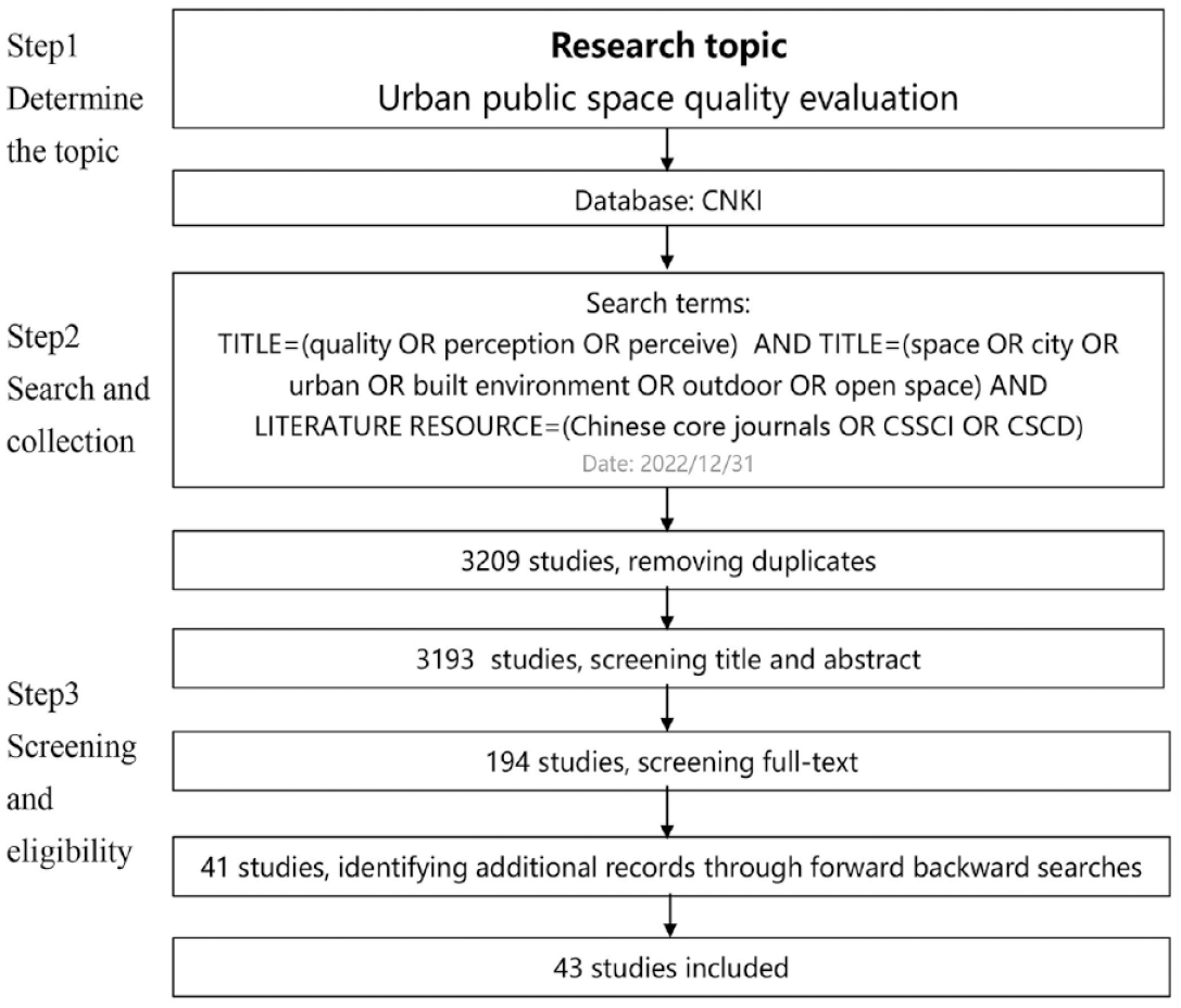
Literature screening process.
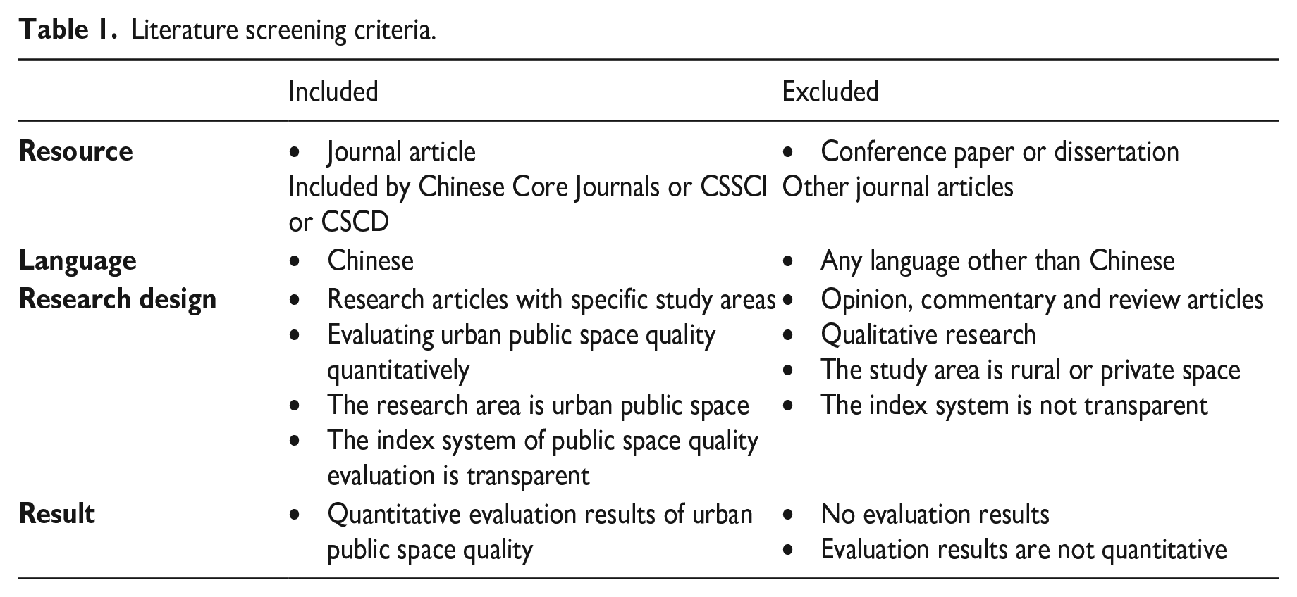
We selected the studies using criteria of source, language, research design, and results, as shown in Table 1. In addition to controlling the source of literature and including only Chinese studies, we used the following four criteria to select the studies in the research design: (1) only those research articles with specific study areas, excluding the types of opinion, commentary, and review articles; (2) studies that evaluate the urban public space quality quantitatively, rather than qualitatively; (3) studies where the study area is urban public space, not rural or private space; (4) studies where the index system for quantitative evaluation of the quality of urban public space is transparent. Finally, in terms of results, studies with precise quantitative assessment results are screened, and articles with no marks or results that are not quantitative are excluded.
Literature screening criteria.
To understand the progress in multiple aspects of the urban public space quality evaluation, we extracted the publication time, study area, author field, spatial scale, research dimension, index system, data, and methods, and research purpose of each study included for further analysis.
Results
Overall situation
Among the included studies, the first Chinese study on evaluating urban public space quality appeared in 2009. Taking Chongqing metropolis as an example, the paper made a quantitative analysis and evaluation of them by combining questionnaires with interviews according to the impression degree, better quality and worse quality of the urban recreational spaces. This study revealed the relationship between quality sorting and tourists’ perception about recreational spaces, thus offering some help to planning, designing, and constructing urban recreational areas (Feng et al., 2019). From 2009 to 2018, studies on the evaluation of urban public space quality were all in the initial stage, with a small number. Since 2019, the number of studies has increased significantly, and Chinese studies on the measurement of public space quality have entered a stage of rapid development.72% of the studies were published after 2019 (Figure 2).
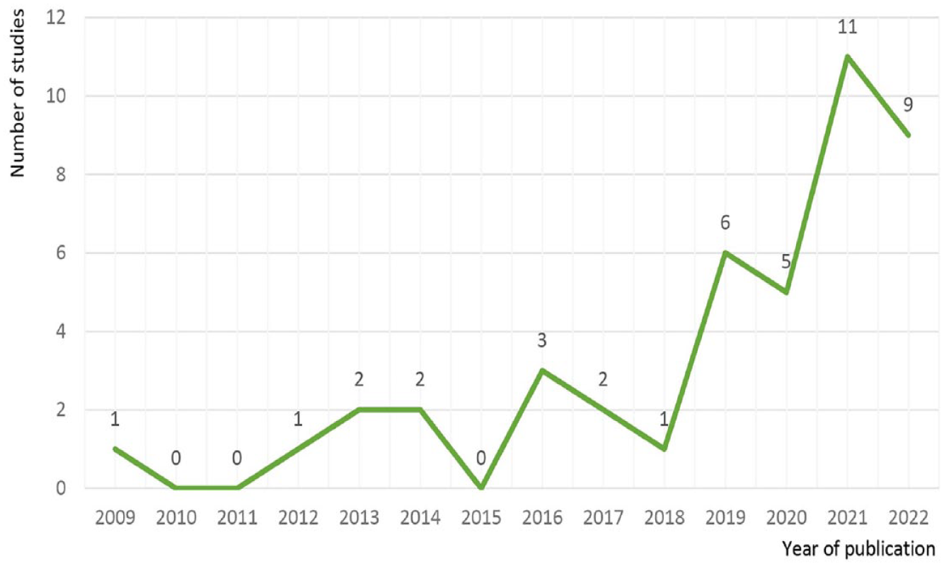
Publication year of studies.
According to the result, most authors of the included studies were from urban planning and architecture, accounting for 62.8% of the total (Figure 3). However, in the past five years, researchers in landscape architecture (20.9%), geography (7.0%), management (4.7%), geographic information systems (2.3%), and design (2.3%) have gradually paid attention to evaluating urban public space quality.
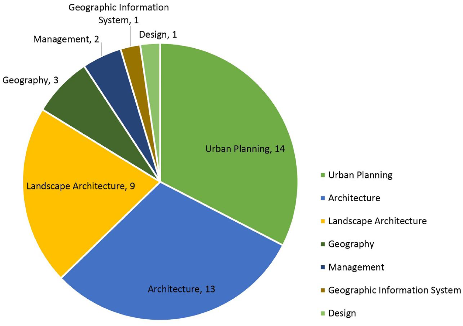
Authors’ fields of studies.
Study area and spatial units
As the capital and one of the most developed cities in China, Beijing was the city that researchers paid the most attention to. The study areas of the seven studies are located in Beijing, followed by Shanghai, Guangzhou, and Chongqing (Figure 4). Some studies focused on medium and small cities with distinctive features, such as Lhasa, a historical and cultural city with ethnic characteristics (Fan et al., 2020) and a snowy plateau, and Qiqihar, a shrinking city with prominent population loss (Li and Long, 2018). One of the included studies taking Beijing and Shanghai as the study area simultaneously analyzed objective elements and subjective assessment and evaluated the street space quality in the central urban areas of these two megacities with streetscape images (Tang and Long, 2017). The most extensive study area study used street view images and a deep learning model to evaluate the spatial quality of 287 major cities in China (Chen et al., 2020). In addition, it is worth noting that a study took virtual space as its area. The subjects were asked to walk, glance, and experience the space on a virtual square on different scales and to answer questions to reflect subjects’ preferences and images on separate “pure” spaces of the square, by which the authors explored the relationship between space scale and quality (Xu et al., 2012).
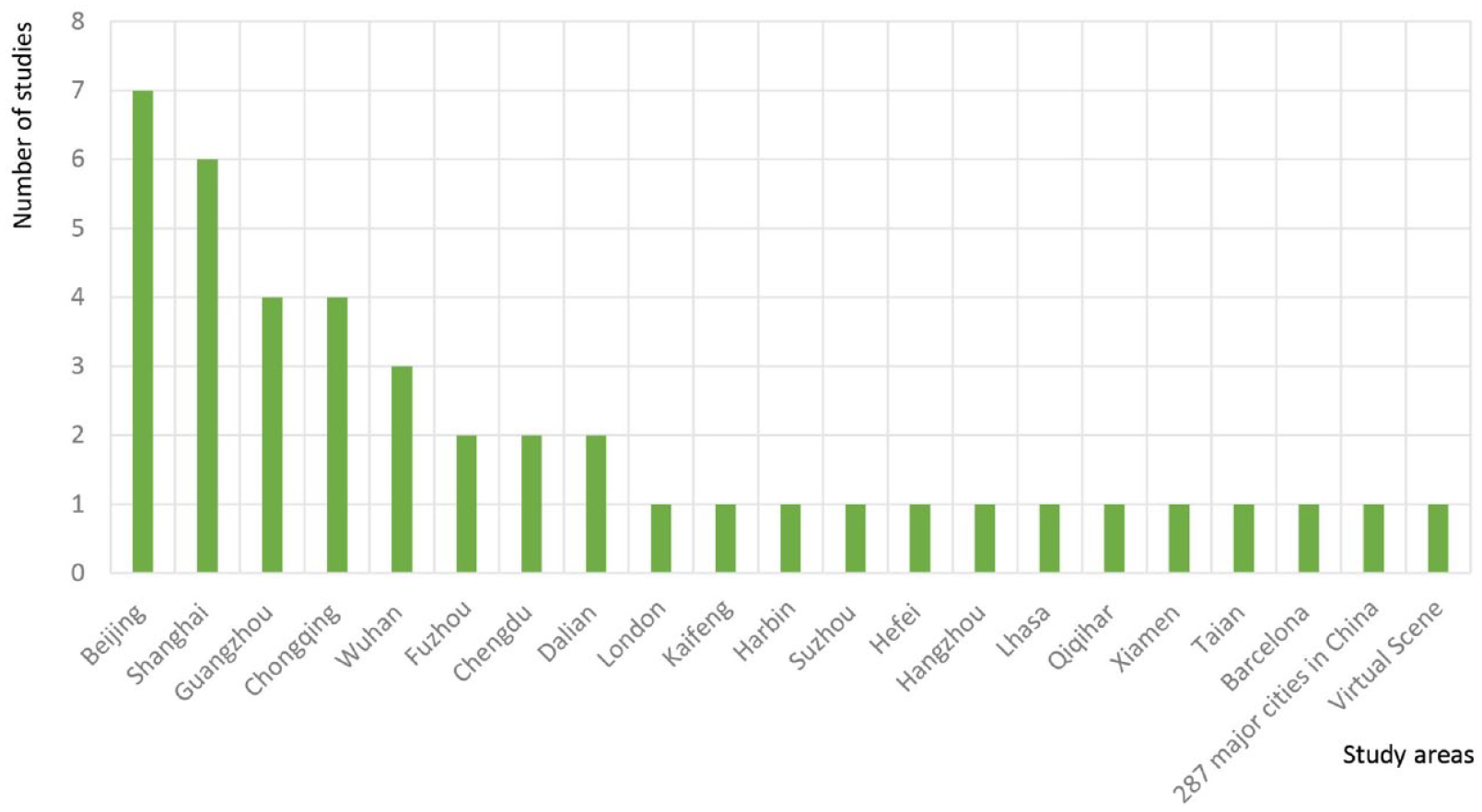
Study areas.
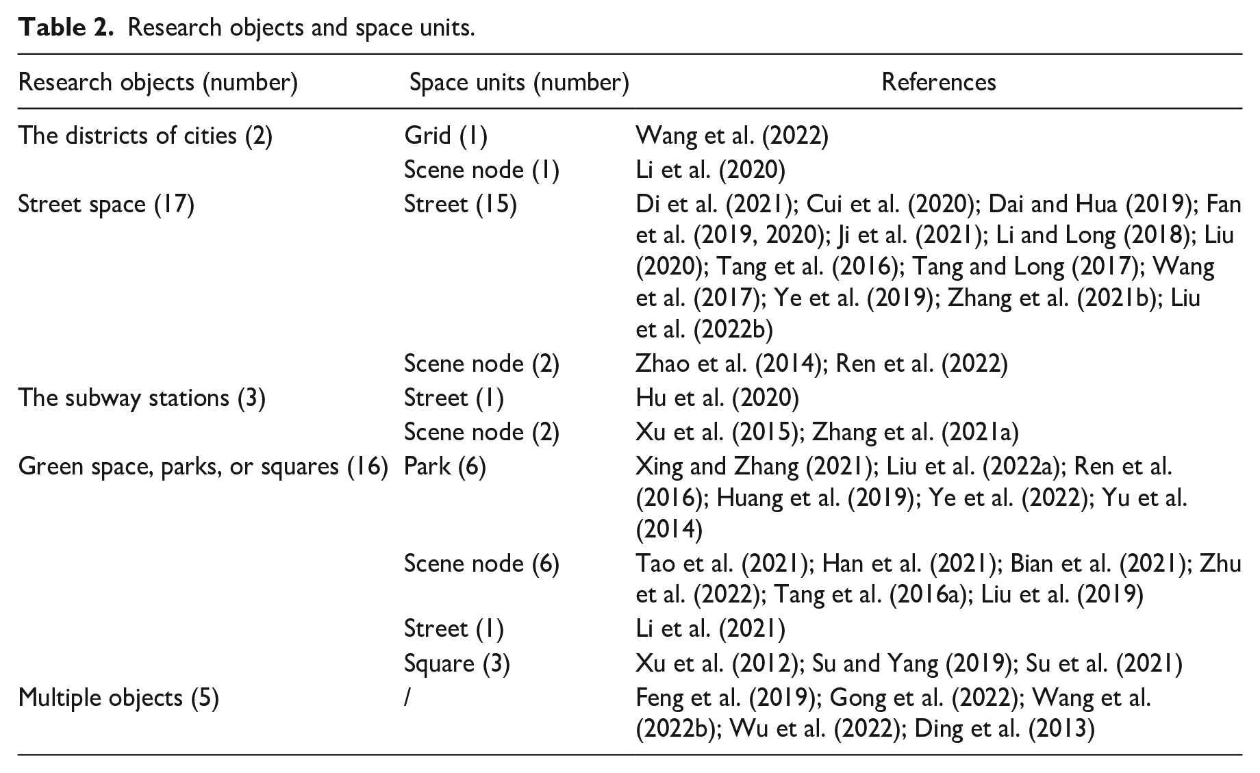
By analyzing the research objects, we find that in addition to focusing on the quality of typical public spaces such as streets, parks, and squares, some studies also took the area around the subway station as research objects, or took multiple types of public spaces at the same time (Table 2). As the widespread and representative public space, the street was the most-used research object (17, 39.5%). Researchers usually used big data such as street view images to evaluate the space quality of streets (Di et al., 2021) or select several representative streets in the area for investigation and evaluation (Liu, 2020). Some studies chose the area’s most typical spatial scene nodes and estimated space qualities (Li et al., 2020). Studies focusing on the quality of atypical public space in residential areas and around subway stations took the street or the whole subway station as the research unit (Hu et al., 2020; Xu et al., 2015; Zhang et al., 2021a). Researchers evaluated critical public spaces in the city, parks, and squares, or selected typical public space scenes in parks for quality evaluation (Su and Yang, 2019; Tao et al., 2021; Xing and Zhang, 2021). Five studies measured the quality of various public spaces in the study area. One evaluated the public space quality of 21 parks, 21 squares, and 21 streets in the main urban area of Dalian City (Gong et al., 2022). Another took the recreational space of Chongqing as the research object and evaluated the quality of various types of public space, such as pedestrian streets, squares, cultural heritage, public green spaces, landmark buildings, and roads (Feng et al., 2019). Wang et al. sorted out the network evaluation text data of four typical Internet-famous spots in Chongqing and perceived their space from the aspects of theme and emotion. The four spots included a commercial street, a sightseeing cableway, a light rail station, and a cultural park (Wang et al., 2022b). Ding et al. (2013) evaluated the visual perception of various open scenic spots in Kaifeng through a questionnaire survey. Based on the behavioral paradigm of eye movement, Wu et al. (2013) recruited subjects to watch street scene videos of the Central Business District, subway station, road and commercial pedestrian street in Beijing to explore the influencing factors of public space perception.
Research objects and space units.
Dimensions of studies
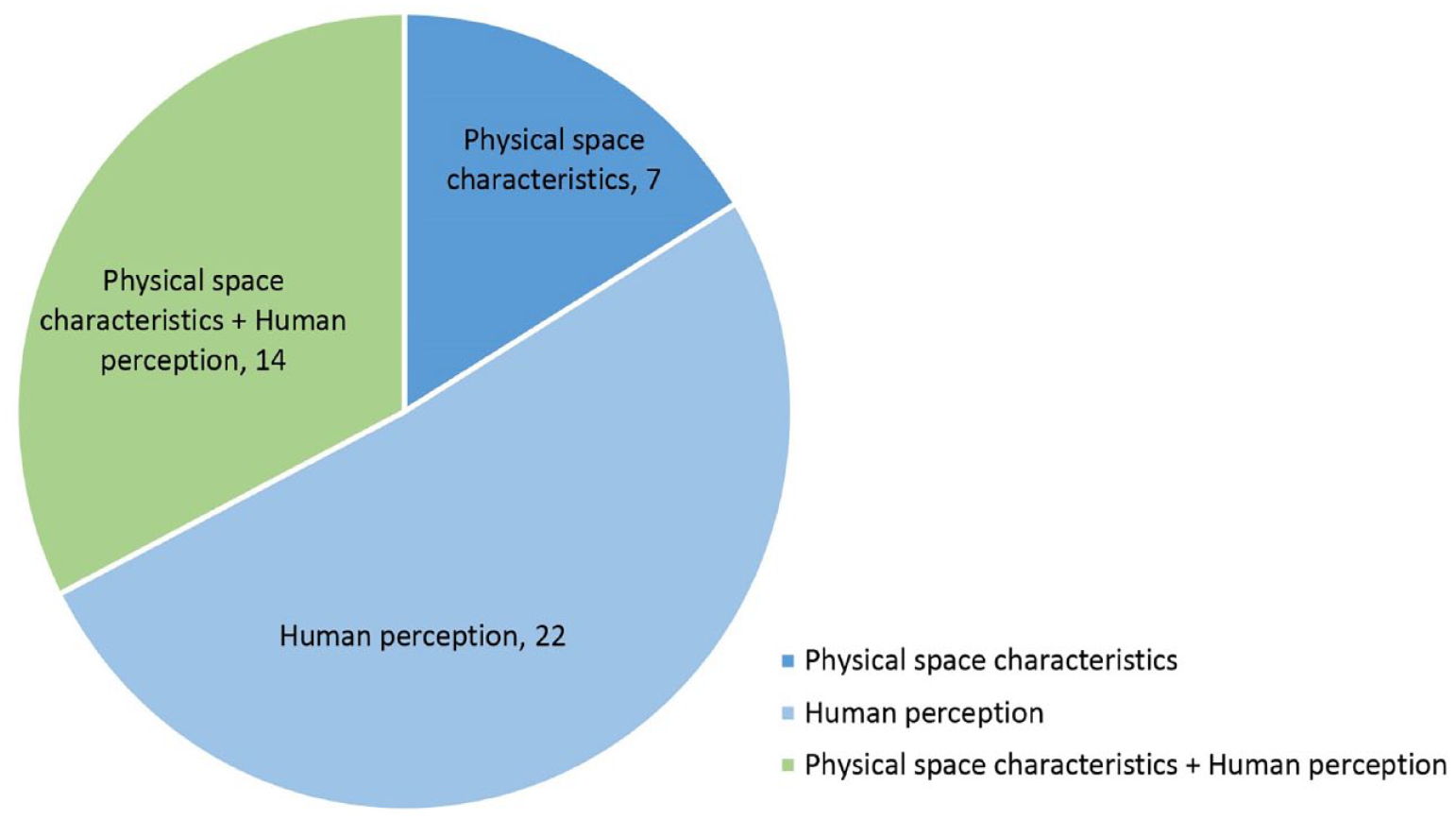
According to the definition of public space quality, the evaluation of public space quality can be divided into two dimensions from the perspective of space and people: the measurement of physical space characteristics and human perception. Urban public space is firstly an objective material space; its core function is to carry out all kinds of general activities in cities. Therefore, the characteristics of objective physical space are the basis of the quality, such as scale, greening level, arrangement of rest space, enclosing degree of the interface, microclimate, etc., which impact human activities and interpersonal communication, thus affecting the public space quality.
On the other hand, from the human perspective, people use public space based on the cognition of their subjective feelings about the public space, to evaluate whether their needs will be met and decide whether to use it. So for users, what matters is the perceived public space. Psychological research points out that people choose information from the physical environment and form a psychological environment based on the report, which can be called the cognitive model (Zhou and Huang, 2003). This is very important for people to decide whether and how to use public space. Therefore, the quality of urban public space quality must contain the content of users’ perception. Still, these are usually more subjective and difficult to be directly measured, such as security, comfort, beauty, and so on.
Among the 43 studies included, 7 studies evaluated the urban public space quality from the physical space characteristics, and 22 studies evaluated the dimensions of human perception (Figure 5). In addition, 14 studies pay attention to both space and human dimensions.
Dimensions of studies.
The index system
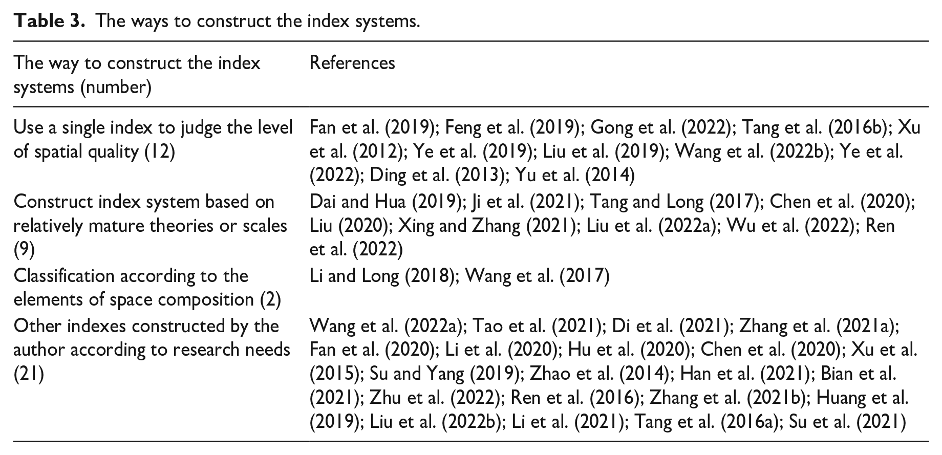
The index system used to evaluate the urban public space quality in the included studies can be divided into four categories (Table 3).
(1) Use a single index to evaluate space quality (12, 27.9%). For example, users are directly asked whether the space quality is good or bad, how they feel about using public space, whether they have a sense of depression, and how much they want to stop, etc. (Fan et al., 2020; Gong et al., 2022; Hu et al., 2020; Tang et al., 2016b; Xu et al., 2012; Ye et al., 2019).
(2) Construct the index system based on relatively mature theories or scales (10, 20.9%). The three studies referred to the significant urban design qualities proposed by Ewing and Handy, including imageability, enclosure, human scale, transparency, and complexity, and then changed or expanded them (Dai and Hua, 2019; Ji et al., 2021; Tang and Long, 2017: 66). In addition, other studies focused on the negative spatial quality, namely spatial disorder, and considered the common space quality problems such as old and damaged buildings, garbage stacking, poor greening level, etc. (Chen et al., 2020). A study focusing on the quality of child-friendly parks used the Child-Oriented Park Quality Assessment Scale (QUINPY) (Xing and Zhang, 2021). Another study constructed the index system, including five aspects based on several critical points of the upper policy construction (Liu, 2020). Two other studies explored the restorativeness of spatial perception using the Perceived Restorativeness Scale (PRS) (Liu et al., 2022a; Wu et al., 2022).
(3) Starting from the elements of space composition, the public space quality was evaluated from street, building, open space, wall, green landscape, and other elements (2, 4.7%).
(4) Other index systems constructed by the authors according to research needs, usually including the form, function, and other indexes of space (21, 48.8%). This is the most commonly used way of constructing index system in the included articles.
The ways to construct the index systems.
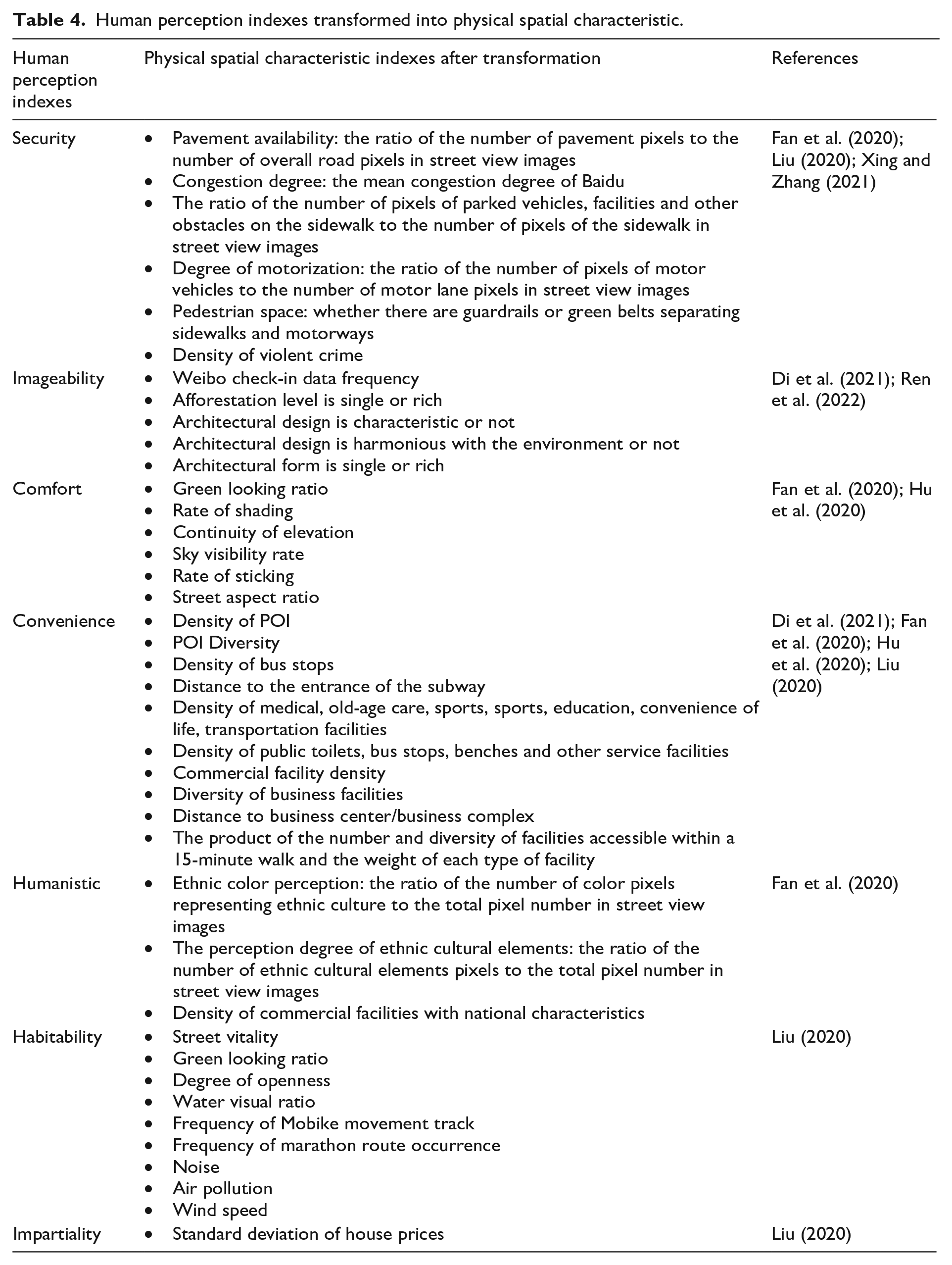
Specific to a single index, it can be divided into the evaluation of physical space characteristics and human perception according to the study dimensions. We made statistics on the use of each index in different study units. Due to space, all human perception indexes and physical characteristics space indexes that have been used more than once have been visualized (Figure 6). The results showed that in terms of physical space characteristics, greening rate, exposure and enclosure were the most used. From the perspective of different study units, the number of studies taking the street as the research unit was the largest, and the indexes involved were also the most abundant. Rather than grids and streets, studies of squares and scene node focus on microclimatic factors, rest facilities and other micro-indicators. It is worth noting that most of these studies evaluate spatial quality based on visual features, but some studies focus on auditory indicators. For example, in three articles, the sound pressure level detected by the sound level meter is used as an indicator to measure spatial auditory quality (Bian et al., 2021; Ren et al., 2022; Su et al., 2021).
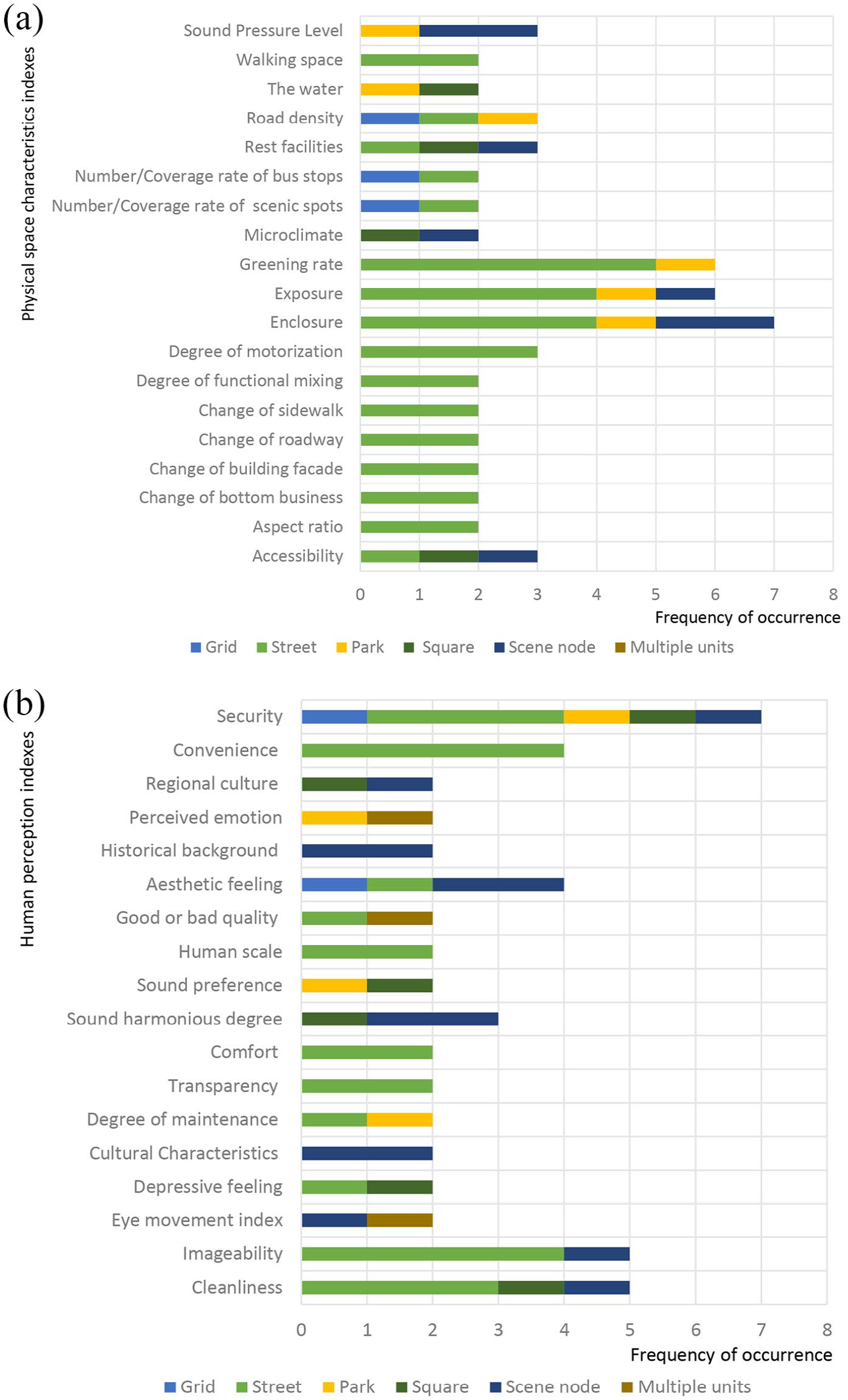
The indexes of urban public space quality evaluation. (a) Physical space characteristics indexes. (b) Human perception indexes.
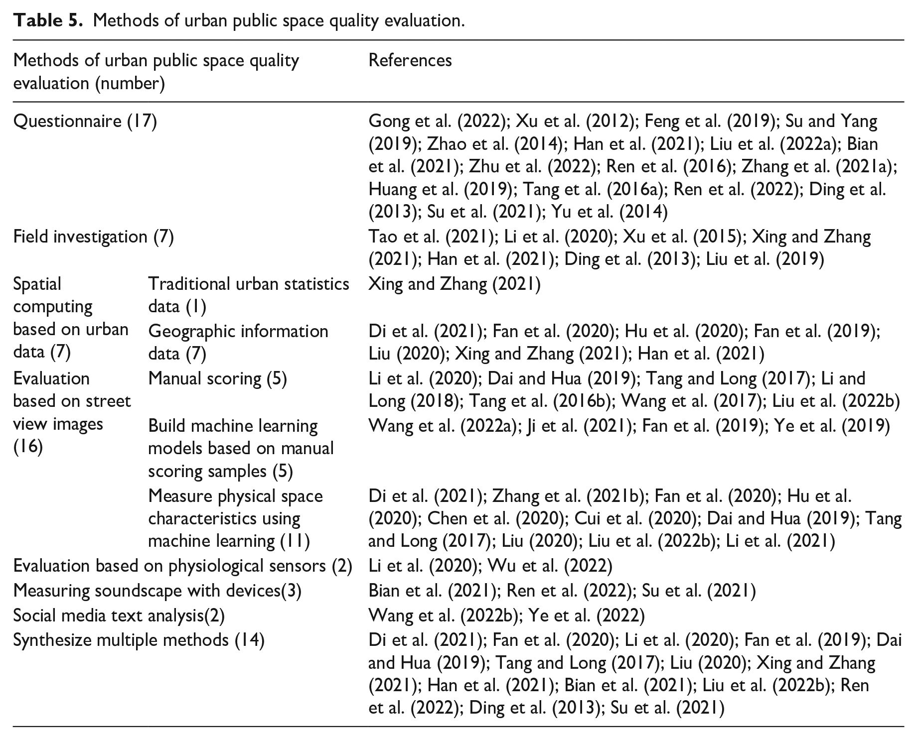
In terms of human perception evaluation, security was the most used index (seven times), followed by imageability and cleanliness. In evaluating human perception, many indexes were relatively abstract and difficult to measure directly. In addition to now asking users about their feelings or ratings, many studies transformed the subjective indicators into one or more specific objective indexes for easy quantification. For example, indexes such as road feasibility, congestion degree, and motorization degree were used to comprehensively determine security (Fan et al., 2020), and the density of violent crime was also used as a proxy for security (Xing and Zhang, 2021). We reviewed the human perception indexes that were converted into physical space characteristics in the included studies and found that convenience and security were used in many studies. The physical space characteristics indexes used to evaluate them were also rich and diversified (Table 4).
Human perception indexes transformed into physical spatial characteristic.
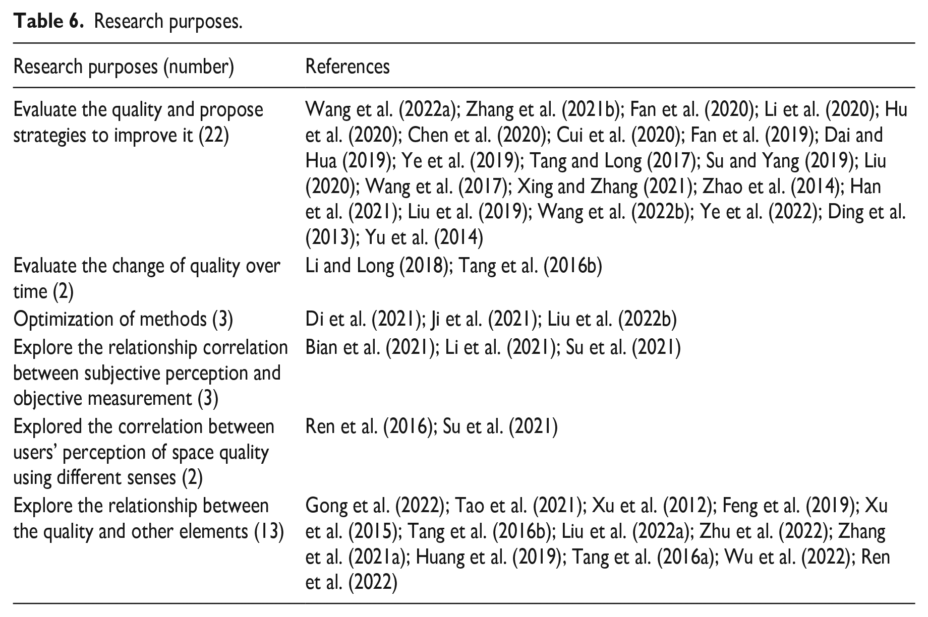
Methods of urban space quality evaluation
We sorted out the methods used to evaluate the urban public space quality in the included studies, and the results showed that the plans were divided into five categories (Table 5). Questionnaires have been an effective way to directly collect users’ perceptions; similarly, field investigation is another traditional way to collect physical characteristics of urban space. Although these two traditional methods are easy to grasp for researchers and the data are more intuitive, yet they consume relatively high labor efforts and thus research ranges are confined. On top of that, urban data with geo-locations are frequently adopted by researchers nowadays as more and more high-granularity databases are being released by governments and high-tech companies in China, which save a lot of time on data collection. Other than that, a new tendency is to apply big data and deep learning technologies to make up for the relatively low efficiency and data-richness of traditional questionnaires and field investigations. New methods such as street view images, online media comments, and personal sensors have been breaking the limitation of data in terms of time and space, which also increases the possibility to track individual perceptions of public spaces.
Methods of urban public space quality evaluation.
Questionnaire
In four studies, a questionnaire survey was used to evaluate the quality of urban public space quality. The questionnaire was used to obtain the respondents’ feelings on the space quality of the study area. One way was to use a single subjective perception index. For example, Xu Leiqing et al. used a five-point scale ranging from very depressed to very open to measure interviewees’ sense of depression after using space to represent their perception of space quality (Xu et al., 2012). Another way was to use multiple indexes to judge users’ public space perception comprehensively. For example, Su Jianming and Yang Cheng understood users’ satisfaction with space through 19 indexes from the material, social, and psychological levels and evaluated the quality of public space by integrating the scoring results of these indexes (Su and Yang, 2019). The advantage of a questionnaire survey is that it can directly understand users’ subjective feelings. Still, the disadvantage is that it is time-consuming and laborious, and the sample of respondents needs to be more comprehensive, can be biased, and other problems.
Field investigation
Another traditional way is to measure the quality of public space through field surveys (4, 16%). The researchers collected the characteristics of the elements of the physical space through field investigation to evaluate the space quality. For example, the site’s temperature, humidity, thermal radiation, and other indexes were measured on the spot to assess micro-climate characteristics (Tao et al., 2021). A study evaluated the spatial enclosure, the proportion of commerce in the interface, and the availability of facilities around the three subway stations through field investigation (Xu et al., 2015). And in another study, 19 physical space characteristic indexes of streets, roads, environmental facilities, and green landscapes in the study area were scored to comprehensively evaluate the public space quality through field investigation (Wang et al., 2017). Due to the high cost and limited efficiency of field investigation, the studies using this method usually aimed at a small research scope, such as a scenic spot in a park, three subway stations, and a street, and it is not easy to achieve a large-scale evaluation of space quality.
Spatial computing based on urban data
In addition to questionnaires and field investigation, spatial calculation using standard urban data is also one of the methods to evaluate the quality of urban public space. Due to the low spatial accuracy of traditional urban statistical information, few studies used it to measure the quality of public space. In one of the included studies, the area of parks and the number of violent crimes were obtained through a statistical yearbook and other general government data, and the quality of parks was assessed together with other data (Xing and Zhang, 2021). Many researchers evaluated the public space quality using the increasingly popular urban geographic information data (7, 28 %). With more kinds and higher precision, big data provides better conditions for the feature measurement of large-scale public space. For example, Di Di et al. used POI data to calculate the dominant function of the street and calculated road density with refined road network data. The check-in data of Weibo was used to reflect the imageability reflection of users (Di et al., 2021). Open street maps (OSM), Baidu Maps, Gaode Map, Tencent Map, and other platforms provide a variety of big data with geographic information, and the numerical quality of Chinese cities is improving day by day, which facilitates the acquisition of basic knowledge of urban public space and enhances the efficiency of quality measurement of public space.
Evaluation based on street view images
The emerging street view images based on human view provide an important essential data source for street research. As big image data directly reflects urban public space, street view images are characterized by a strong sense of reality, a rich degree of information, and comprehensive coverage, which can effectively describe urban public space scenes and make up for the deficiencies of non-visual data (Naik et al., 2017). Currently, street view images have been widely accepted as an effective means to evaluate the built environment, and it is also the most used method in the included studies (16, 64%). There are two types of street view images in the included studies. Most studies used street view images provided by internet platforms such as Baidu and Tencent. It is usually crawled through an open API interface depending on the scope of the study. Its data access is convenient and not subject to weather, time, or place restrictions. However, in the case that the street view images provided by the internet platform did not cover the research area or did not meet the study demand, two studies obtained street view images using self-collection. Street view images were collected along the road inside the community by simulating the activities of pedestrians from the perspective of pedestrians (Zhang et al., 2021b). The other study collected and screened 28 typical photos of spatial scenes that can fully and genuinely reflect the spatial morphological characteristics from the perspective of pedestrians in Hankou, Wuhan (Li et al., 2020).
The methods of using street view images to evaluate public space quality can be divided into three categories. Firstly, some studies used street view images to replace field scenes. Researchers (or recruited volunteers) perceived and scored all the street view images of the study area to evaluate the public space quality. For example, the raters were asked to score the street scene images of the central urban areas of Beijing and Shanghai from the five aspects of the enclosure, human scale, transparency, cleanliness, and imageability, and combined with other physical spatial characteristics to evaluate the street space quality (Tang and Long, 2017).
The advances in the computer field in machine learning also have a positive spillover effect on the research of the built environment. To further improve efficiency, some researchers manually scored a small number of street view images and used machine learning technology to quickly and efficiently go through all the streets in the study area according to the manually scored samples (Fan et al., 2019; Ji et al., 2021; Wang et al., 2022a; Ye et al., 2019). Artificial Neural Network (ANN) (Fan et al., 2019; Ye et al., 2019) or Convolutional Neural Network (CNN) algorithms (Ji et al., 2021; Wang et al., 2022a) in the field of machine learning were usually used to construct the evaluation model. The evaluation models were trained based on relatively small samples’ street view image evaluation results. They formed the quality judgment ability of class experts to conduct large-scale evaluations and ratings of all street view images.
In addition, many studies automatically identified street elements and measured physical space characteristics indexes using image segmentation in machine learning. SegNet, the deep fully convolutional neural network architecture segmentation technology of pixel level, was usually used in the studies to extract street spatial feature elements (such as street greening, sky, buildings, and roads, etc.) in fine detail and calculate the proportion (Dai and Hua, 2019; Di et al., 2021; Tang and Long, 2017; Zhang et al., 2021b). For example, by calculating the proportion of trees as the visible green rate of this point, the street exposure was measured by the sky ratio, and the sum proportion of buildings, columns, and trees was used as the interface enclosing degree (Tang and Long, 2017). These physical space characteristic indexes were used to evaluate the public space quality. As mentioned above, multiple space characteristic indexes, which were easy to quantify, were used to comprehensively determine the human perception indexes and then evaluate the public space quality.
Evaluation based on physiological sensors
The maturity and mobility of physiological sensors technology also provide a new means for the intelligent evaluation of public space quality (Tang and Long, 2019; Zhang et al., 2018). A study used eye-tracking metrics (ETM) to reflect subjects’ perception through eye movement indexes such as the total number of fixation points, fixation frequency, and fixation time, and to understand the elements people pay attention to in space through the analysis of fixation hotspots. Physiological phenomena reflect psychological characteristics to a large extent. This kind of technology can break through the subjective component of users’ evaluation of the scene or image to a specific time and make it possible to collect people’s feelings and information in real time.
Measuring soundscape with devices
A few studies specifically focus on the soundscape perceptions of urban recreational green space (Ren et al., 2016), greenways (Bian et al., 2021), and urban parks (Liu et al., 2022a) to provide guidance on improving the quality of urban green space . Based on the current studies, the general categories of soundscapes can be divided into natural sound, living sound, and mechanical sound. Most of these studies tried to build associations between the frequencies of hearing a specific sound and their emotional feedback using a combination of questionnaires.
Social media text analysis
New media has refined the concept of leisure activities nowadays. It is worth noting that online media and people’s comments and communications over such platforms has an increasing influence on the community’s choice of travel destinations. Abundant text data that contains individual subjective information has made it possible for researchers to understand spatial perceptions of certain public spaces, such as internet-famous Spots (Wang et al., 2022a) and urban parks (Ye et al., 2022). The main procedures include sourcing text comments on social media of research areas, preprocessing the texts, breaking down sentences into segments, picking up the frequent keywords, and applying deep learning technologies to perform text sentiment analysis to get emotional tendencies – negative, neutral, or positive. Such methods provide a new perspective to sense public space qualities, however, may be largely improved by the advancements in algorithm and basic language library of the text sentiment engines.
In general, new data and technology gradually transform the method of evaluating public space quality. Multivariate big data and the continuous development of artificial intelligence technology have brought new possibilities for assessing public space quality in terms of analysis scale and content. Fourteen studies used multiple methods to complement each other and measure together, evaluating urban public space quality more accurately, and comprehensively, with high precision and efficiency.
Purpose of urban space quality evaluation
The purpose of most included studies (22, 51.2%) was to evaluate the space quality of the study areas and propose strategies to improve quality only (Table 6). It is worth noting that two studies assessed the temporal variation of space quality. The changes in street space quality in Qiqihar and Beijing were manually identified using street view images over many years (Li and Long, 2018; Tang and Long, 2019). Three studies put forward the optimization in the method of measurement. In one of them, with the support of new data and new technology, a multi-dimensional and sub-index comprehensive evaluation framework of urban street spatial quality was constructed, which took into account the characteristics of street shape and the perception and behavior characteristics of users, and the evaluation efficiency was tested based on the comprehensive evaluation results and the comparison of consensus cognition (Di et al., 2021). In another study, a machine learning method combined AlexNet and Support vector regression (SVR) was designed to evaluate urban space quality attributes by a manual annotation data set using street view images (Ji et al., 2021). In the study by Liu et al., six types of urban perception models were established based on the street view images, coupled with perception scoring data and Random Forests algorithm. Then, based on the Shapley value method, the impact of various urban ground objects on human perception in the forest model is decomposed. Finally, combined with the decomposition results, the applicability and advantages of the Shapley value method in the nonlinear model are explored (Liu et al., 2022b). Three studies creatively focused on the correlation between subjective perception and objective measurement of space quality. Li et al. used the multiple linear regression model to explore the relationship between landscape features and visual perception (Li et al., 2021). Bian et al. and Su et al. explored the correlation between objectively measured sound pressure level and subjectively perceived soundscape quality (Bian et al., 2021, Su et al., 2021). Two studies explored the correlation between users’ perception of space quality using different senses, and analyzed the correlation between users’ auditory perception and visual perception in the same space (Ren et al., 2016, Su et al., 2021). In addition, 13 studies explored the relationship between the urban public space quality and other urban characteristics, such as awareness, number of users, user impression, user environmental attitude, user individual factors, site function, spatial scale, environmental design factors, space attraction, space vitality, etc. (Feng et al., 2019; Gong et al., 2022; Liu et al., 2022a; Ren et al., 2022; Tang and Long, 2019; Tang et al., 2016a; Tao et al., 2021; Wang et al., 2019; Wu et al., 2022; Xu et al., 2012; Zhu et al., 2022; Zhang et al., 2021a).
Research purposes.
Discussion
Discussion of the findings
This paper adopted a systematic literature review to understand the research progress of urban public space quality evaluation in China. It made a statistical analysis of 43 studies on the quantitative assessment of urban public space quality. Unlike previous studies focusing on a specific direction or scale, this paper comprehensively presented the full picture of the research progress of Chinese publications on the evaluation of urban public space quality. It is helpful for more scholars, planners and policy makers to understand the research on the quality of urban public space in China.
Since 2019, more and more Chinese researchers have paid attention to the evaluation of the quality of public space quality. In addition to urban planning and architecture, other disciplines have shown interest. All these indicate that Chinese scholars are increasingly interested in studying the quality evaluation of urban public space. But the existing study areas mainly focus on densely populated and economically developed mega cities in China, such as Shanghai and Beijing, and lack of attention to other cities. Some studies evaluated the quality of public space in small and medium towns, but few explained the study area’s characteristics and representativeness. The street was the type and research unit of public space that received the most attention. This may be due to the widespread use of street view images, and relatively few studies evaluated the quality of other public spaces. When constructing the index system, the authors selected the most commonly used index according to the availability and operability of data, and there was a lack of reference for the theory. Among many indexes, greening rate, exposure, enclosure, convenience, imageability, and cleanliness were widely used to evaluate the public space quality. Some studies transformed human perception indexes, which were difficult to be directly measured, into one or more physical space characteristic indexes. However, whether these physical space characteristics can accurately reflect the subjective perceptual indexes remains to be considered and further verified.
Although the conventional way can obtain more comprehensive and detailed information, it is very time-consuming and laborious, making it impossible to conduct large-scale urban quantitative research and refine the spatial scale. A series of new data and technologies have brought new possibilities for public space quality evaluation in terms of analysis scale and measurement content. The latest data environment provides multi-source data of fine-scale spatial form and users’ perception, which makes it possible to grasp the public space attributes and characteristics in a multi-scale and quantitative way. At the same time, the development of new technology provides quantitative analysis tools and related algorithms for the studies of urban spatial form, function, behavior, and perception. It provides technical means for refined and human-oriented spatial analysis. The integrated use of new data and technology represented by street view images and machine learning has made it easier to obtain primary spatial data and use street view images efficiently. Applying relevant algorithms of machine learning technology can provide refined preliminary data for spatial quality research and rapidly process large-scale data while ensuring refinement, which solves the problem that large-scale traditional data is difficult to be refined while refined local information is challenging to represent the whole situation. It makes it technically possible to measure previously unmeasurable space qualities. However, take advantage of new technology and data while facing its limitations. For example, the information displayed by street view images is almost the same as that of traditional surveys in visual terms. Still, it cannot reflect other environmental factors such as temperature, smell, and sound for the time being. In general, more and more studies are using new data and new technologies or combining old and new methods to evaluate the quality of public space quality, which has become a significant feature of relevant research development.
In terms of study purposes, most of the existing studies were limited to measuring the status quo of the public space quality and proposing some strategies to improve the quality. Only few studies can put on innovations in the evaluation methods or pay attention to the externalities or influencing factors of public space quality.
Future directions
Currently, Chinese studies on evaluating public space quality have made some progress. Based on the results of the systematic literature review, this study predicted trends in the future development of the research on the quality of urban public space in China and recommended new research directions by the following aspects.
Firstly, it is suggested that researchers pay more attention to the quality of public space in cities with characteristics and typical cities, and focus on the quality of multiple types of public space, which can promote the diversification of research on evaluating urban public space quality in China.
Secondly, more scientific public space quality evaluation index systems should be built. At present, there is still little effective integration of multi-dimensional factors in public space quality evaluation index systems. Overlaps or contradictions widely exist between various factors in many index systems, and the mutual influence relationship of these factors is not clear enough. The current studies lack enough comparison of different evaluation methods. There is an urge for the breakthrough in the field of evaluation of the urban public space quality itself. Therefore, it is still very necessary to sort out the relationship between the factors of different dimensions in an index system, and more explicit theories on the quality of urban public space is still needed to build a more reasonable integrated evaluation index system.
Third, the future research should have a more systematical consideration about the evaluation dimensions including both physical space characteristics and human perception to make the evaluation process more rigorous and the evaluation results more credible. Existing research tends to concentrate more on physical space characteristics as they are easier to be analyzed. In terms of evaluating the human perception, it includes both physiological and psychological senses. Current studies are generally limited to the sense of vision, and only a very limited number of studies paid attention to the sense of hearing and psychological senses. The perception of other senses, like touch, olfaction, or taste, has not been reflected. Although some researchers have explored new methods such as physiological sensors, environment measuring equipment and text analysis tools, these new methods are still rarely used at present. Combining more diversified ways to conduct a more comprehensive and complete evaluation of public space quality may be one of the future development directions for evaluating the quality of urban public space.
Meanwhile, further studies may explore changes of quality from the perspective of spatial-temporal changes, externalities, and influencing mechanisms. The deep research on the influencing mechanisms shaping the urban public space quality is still rare currently. With the wide spread of smart technologies, cities and people’s needs are experiencing changes. How to interpret the quality of urban public space in the context of future human habitats may be an important direction for future studies.
In addition, the direct role of existing research in supporting planning and design needs to be strengthened. The current studies mainly focused on the calculation methods and quantitative description of the existing urban public space quality, while studies on the relationship between the theoretical evaluation and practical optimization is very limited. Some studies used new technologies like artificial intelligence models or sensing equipment to calculate certain indicators of the quality of urban public space, but their roles in supporting decision-making are still not clear enough. This research gap should be considered more in future studies to make the evaluation more effective for optimizing the planning and design to improve urban public space quality.
Finally, it is necessary to develop more suitable theories and methods for Chinese cities concerning local conditions. Most of the current studies began with the theories of urban morphology from Western countries, and most of the Chinese studies just introduced and applied these theories as it is, lacking adequate consideration on local conditions in China. It is thus suggested that the conceptual system and methodological framework directly based on the development stage, cultural and social background as well as morphological characteristics in China should be more explicit and comprehensive in future studies.
Conclusions
Through statistical analysis of 25 articles systematically screened, it was found that the Chinese literature on the evaluation of urban public space quality has increased significantly in the past five years. The study areas are concentrated in major Chinese cities such as Shanghai, Beijing, and Wuhan, and streets are the type of public space that has been evaluated the most.
The methods included in the study to measure the quality of public space can be roughly divided into five categories. They are questionnaires, field investigation, spatial computing based on urban data, evaluation based on street view images, and evaluation based on physiological sensors. The existing studies most often used street view images combined with machine learning to measure the quality of public space.
The primary purposes of existing studies are still to describe public space quality and propose quality improvement advice simply. There are a few innovative pathways left to have deeper insights on the measurement, influencing mechanism, optimization and theoretical localization of urban public space quality. Therefore, there is still significant research vacancy for evaluating urban public space quality in China in the future.
Footnotes
Acknowledgements
We thank Huimin Zhao and Wenzhu Li for their advice.
Declaration of conflicting interests
The author(s) declared no potential conflicts of interest with respect to the research, authorship, and/or publication of this article.
Funding
The author(s) received no financial support for the research, authorship, and/or publication of this article.