
Abstract
Equalization of land rights is a noble goal for societies to pursue. The reform of farmland to the tiller has significantly transformed Taiwan’s agricultural economy and paved the way for rapid industrialization. Nevertheless, market-led equalization of urban land rights may result in unfavorable effects that prevent scarce urban land resources from optimal utilization. The research of Wanhua Railway Station redevelopment zone has discovered the phenomenon of the double-tragedy of the commons and anti-commons. Fragmented land rights hamper redevelopment efforts and induce illegal construction instead. Double-tragedy leads to social segregation that amplifies inequality between urban neighborhoods.
Keywords
Introduction
Dr. Sun Yat-Sen’s doctrine of equalization of land rights has profound impacts on rural as well as urban landscapes. Equal distribution of farmland to farmers by the state is meant to reduce the inequality between landlords and tenant farmers, and it also intends to enhance agricultural productivity. Urbanization accentuates the land asset value, and thus urban land reform in terms of equalization focuses on the increment of land value that should be accrued to the public via land taxation. State-led equalization is imperative for the development of high-density regions in the early stage of an agricultural economy. Market-led equalization of urban land rights also serves the purpose of achieving social equity.
This research chooses the case of Wanhua Railway Station (WRS) redevelopment zone in Taipei in order to throw light on the mechanism of market-led equalization of land rights and its impacts. The built-in momentum of land subdivision equalizes the land ownership, but it also creates fragmentation of land rights. Land rent dissipation because of fragmented land holding induces social segregation, and clustering of the low-income households tends to deteriorate a place physically and socially, which further attracts low-income inhabitants. Low-income households are often tempted by high land prices to sell a part of their land holding for cash much needed for their family urgencies.
Excessive equalization of urban land ownership has given rise to a double-tragedy of the commons and anti-commons. Redevelopment of the WRS zone is hampered by high transaction costs in land assembly because of the fragmentation. Illegal construction has been rampant, which degenerates the WRS zone into deterioration with a concentration of low-income households. Ironically, equalization of urban land rights results in social segregation, which creates inequality between neighborhoods.
Urban governance under the land rights regime
Property rights link the economic system with political structure and legal regime. Land rights are an important institution for urbanization. Land rights are primarily a bundle of rights associated with ownership, which consists of the right to 1) use land, 2) derive income from it, 3) change its form and substance, and 4) alienate the rights mentioned above to another party at a price mutually agreed upon according to rules. The market of urban physical development is structured by the institution of land rights that are considered essential for urban governance (Fischel, 1985).
Because of heterogeneity, low liquidity, high transaction cost, and location fixity in relation to land and buildings, externality becomes an intrinsic attribute to land and land development. Therefore, land use and development have to be defined by land use planning in order to internalize detrimental externalities. Planning controls, which attenuate the land rights by the state’s intervention, are regarded as positive in making the land market efficient and equitable. Without a detached and disinterested state to enforce rules, externalities and short-term behaviors ensue at the expense of welfare of neighborhood and interests of the general public.
Equalization of land rights led by the government
Dr. Sun Yat-Sen, the founding father of the Republic of China, had set ‘equalization of land rights’ as the foundation of his political movement. After the Nationalist Party of China fled to Taiwan, the government carried out a series of land reforms to enhance the welfare of tenant farmers and equalize farmland holdings. There were 876,084 hectares of farmland stock for a total of 4,498,350 rural population in 1952, only 0.19 hectares per rural people and 1.21 hectares per rural household that relied on farming only for livelihood. According to statistics, tenant farming households accounted for 68% of the total rural households (Tang, 1954).
The first measure of the land reform was to cap farmland rents at 37.5% of crop yields under the 37.5% Arable Rent Reduction Act. Its rationale was based on the assumption that the working capital contributed by farmers was about 25% of the total agricultural harvest. The remaining 75% of the crop yield should be split into two halves, one for the landlords (and thus 37.5%) and the other for the farmers themselves. Moreover, as long as tenants have paid land rents at 37.5% for land leasing, tenants’ right to use farmland is secured and even perpetuated. Land use rights held by the tenants have become an independent attribute of land ownership. In case of land sales by the landlords, existing land leasing contracts could not be terminated. Thus the prices of land plots with incumbent tenancy are about two-thirds of the prices of land without existing tenancy (Taiwan Review, 1953). The impact of the 37.5 Act still lingers on, though the land area with such leases only accounted for 3.2% of the total farmland up to 1991 (Hsiung, 1992).
On top of rent cap, under the ‘land to the tiller’ program, occupant tenants could purchase state-owned farmland. It was followed by the policy that set the limits to large private landholdings that landlords could hold, and land exceeding the limit was to be sold to the tenants at state-regulated prices. As a result of the land reform, 235,244 hectares of farmland (27.2% of the total farmland in 1949) were provided to 360,266 farming households (58.0% of the total farming households in 1949) (Taiwan Review, 1963). Farmland ownership became more equalized. Eighty-seven percent of the farmers tilled land of their own in 1964 (Taiwan Review, 1964).
Impact of urbanization on land asset value
Taiwan’s economic transformation driven by industrialization and urbanization has been extraordinary since 1950. The agricultural sector contributed 32.2% to the GDP and employed 56.0% of working population in 1952. The land-to-the-tiller reform directly improved the agricultural productivity as the tillers were incentivized for efficient production. The share of agricultural sector in GDP declined continuously to 15.5% in 1970, 4.2% in 1990, and 1.8% in 2017, respectively. Correspondingly, the agricultural sector accounted for 36.7% of the total employment in 1970, and 12.5% in 1990, respectively (Cheng, 2001). The urbanization rate was only 26.8% in 1950. It rose to 36.5% in 1970, 66.3% in 1990, and further to 80.1% in 2023, respectively (CIA, 2024; Statista, 2024).
Average farmland holding per farmer was 1.45 hectare in 2014, and it increased to 1.57 hectare in 2023 (Yang and Hsiao, 2024). Per capita farmland holding in 2023 was 8.3 times of that in 1952. Farmland becomes less scarce over the course of urbanization, while competition for urban land is intensified along with the increase of urban population. Competition for urban land uses escalates the land asset value. Land reform in the name of equalization of land rights also extended to the urban domain in the early 1950s. Urban land reform was mainly about land value taxation. Appreciation in land asset value should be reaped by the public, in the belief that land value increment is due to general economic development, urbanization, and public investment (Lin, 1984). Lin (1984: 341) claimed that ‘[t]he progressive rates of land value tax are designed to break up large holdings’, as landlords of large land holding wished to reduce tax payments. According the statistics, the average parcel size of privately owned land in Tainan decreased from 0.13 hectare (1970) to 0.09 hectare (1978) (cited by Lin, 1984: 342). In Taipei, the number of land owning households increased from 50,216 in 1964 to 226,578 in 1978 (cited by Lin, 1984: 342). Breaking large land plots into smaller ones is conducive for social equality as more households can become land owners, but smaller land plots impinge on land use efficiency that is equally crucial for high-density cities. 1 Thus urban governments are empowered to carry out consolidation of fragmented land parcels for urban renewal that is of public interest, subject to agreement by over 50% of concerned land owners as well as over 50% of land areas combined.
The case of Wanhua Railway Station (WRS) redevelopment zone, Taipei
Wanhua, historically known as Bangka, is one of the oldest central areas of Taipei. It is situated in the southwest of Taipei City (see Map 1). Located in Wanhua, Long-Shan Temple, built in 1738, has been one of the most culturally significant temples in Taiwan. It is a symbol of traditional religion from Ming-Nan of China. It shows the evidence of early agricultural cultivation and commercial activities of Ming-Nan migrants. Wanhua Railway Station, built in 1901, is to the south of Long-Shan Temple and in the center of Wanhua. The research area, outlined in red (see Map 3, left), was listed as one of the 50 prioritized redevelopment areas of whole Taiwan in the ‘Speeding up Urban Redevelopment Program’ by the Taiwan government in the 1990s (see Map 2). The designated area is 39.5 hectares in size, and about 60% of it has been designated for regeneration.
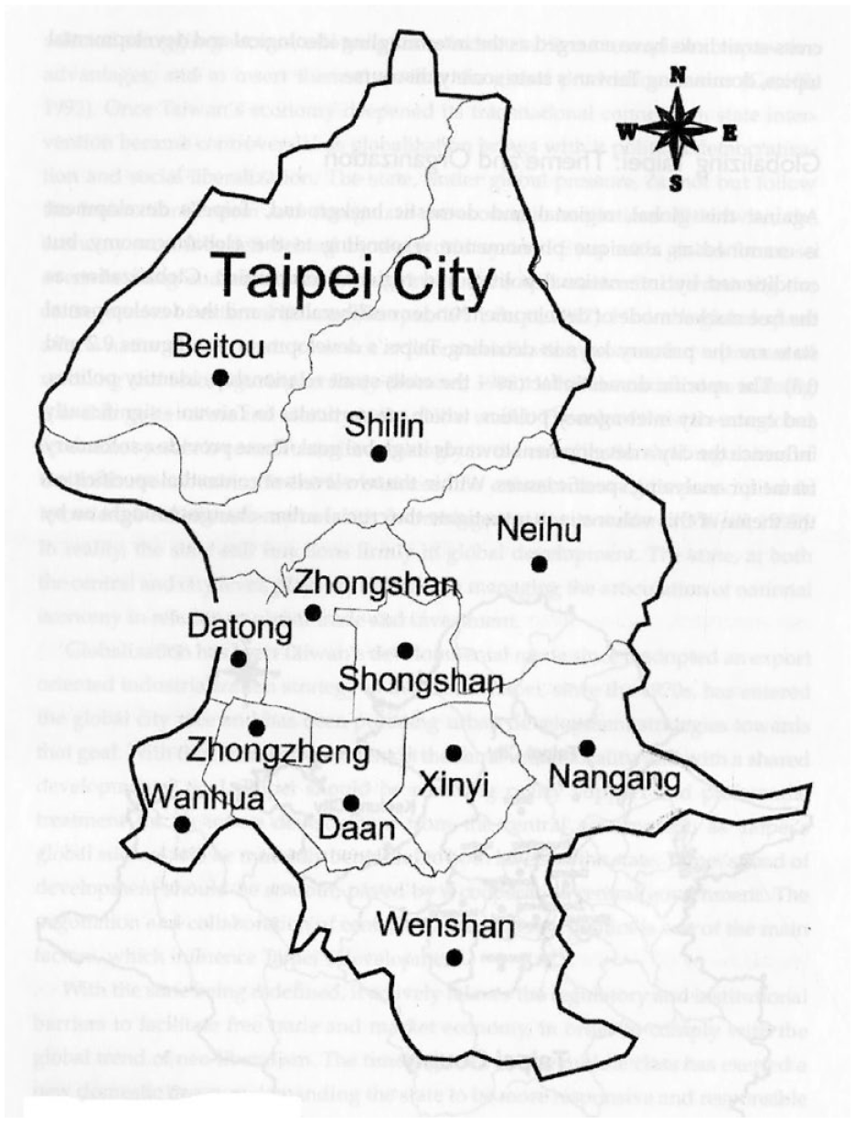
Wanhua in Taipei City.
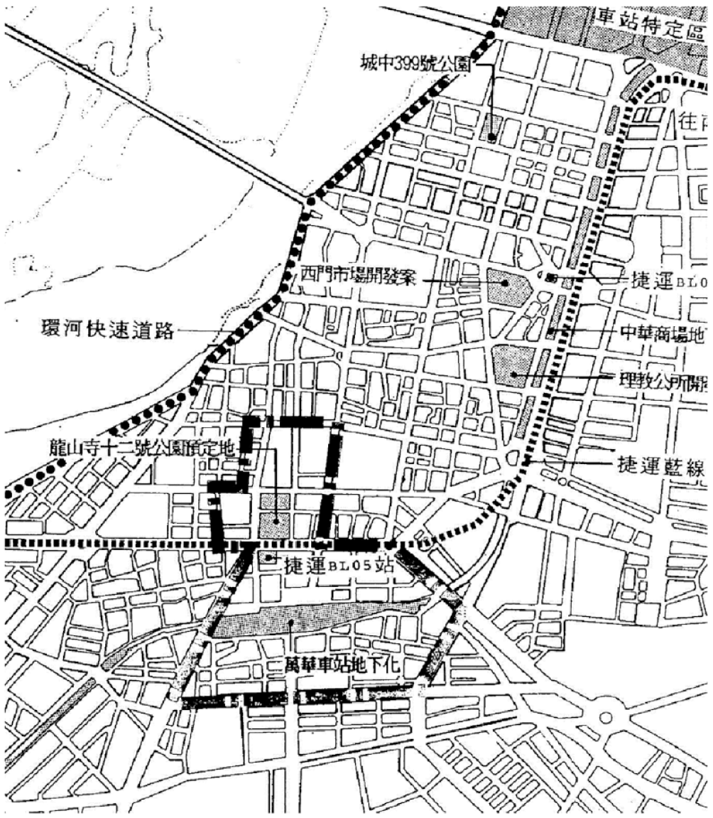
Wanhua Railway Station redevelopment area.
Wanhua has been identified as a strategic regeneration focal area by the Taipei municipal government. Mr. Ma Ying-Jeou during his mayorship of Taipei (1998–2006) proposed to pay attention to the regeneration of old downtown in the west (fanzhuan zhouxian, xidong bingju, 翻转轴线,西东并举). Since the 1960s, the central business district (CBD) has been moving eastward, first to the district of Zhongxiao Road, East and then to Xinyi, where Taipei 101 was built in 2004. The planning initiative intends to revitalize the WRS redevelopment zone so as to remake it as the CBD in the west of Taipei. It has achieved a partial success. The twin tower located in the WRS has been built, and named Bangka 101 in 2017, corresponding to Taipei 101 in the east CBD. In collaboration with the redevelopment of Wanhua Railway Station and public road works, regeneration planning of the WRS redevelopment zone encourages participation of private land owners by providing necessary incentives in relation to zoning changes.
The WRS case study intended to study how bottom-up forces and government efforts formulate urban spatial texture in the context of private landownership system. As the fieldwork had discovered the WRS maps for 1969 and 2007, the research focused on the spatial changes that occurred during the period 1969–2007 (see Map 3). The research team then searched the ‘Taipei City GIS e-Map’ in the public domain for redevelopment and refurbishment projects and found 220 registered cases (see Map 4). There are a couple of government initiated redevelopments on state-owned land or on land parcels compulsorily acquired: Long-Shan Temple conservation, Long-Shan Temple MRT Station, Wanhua Park, Wanhua Railway Station refurbishment, opening up new urban roads, widening existing roads etc. These are social facilities, infrastructure, and public amenities. The majority of redevelopments were carried out by individual land owners on their privately owned land.
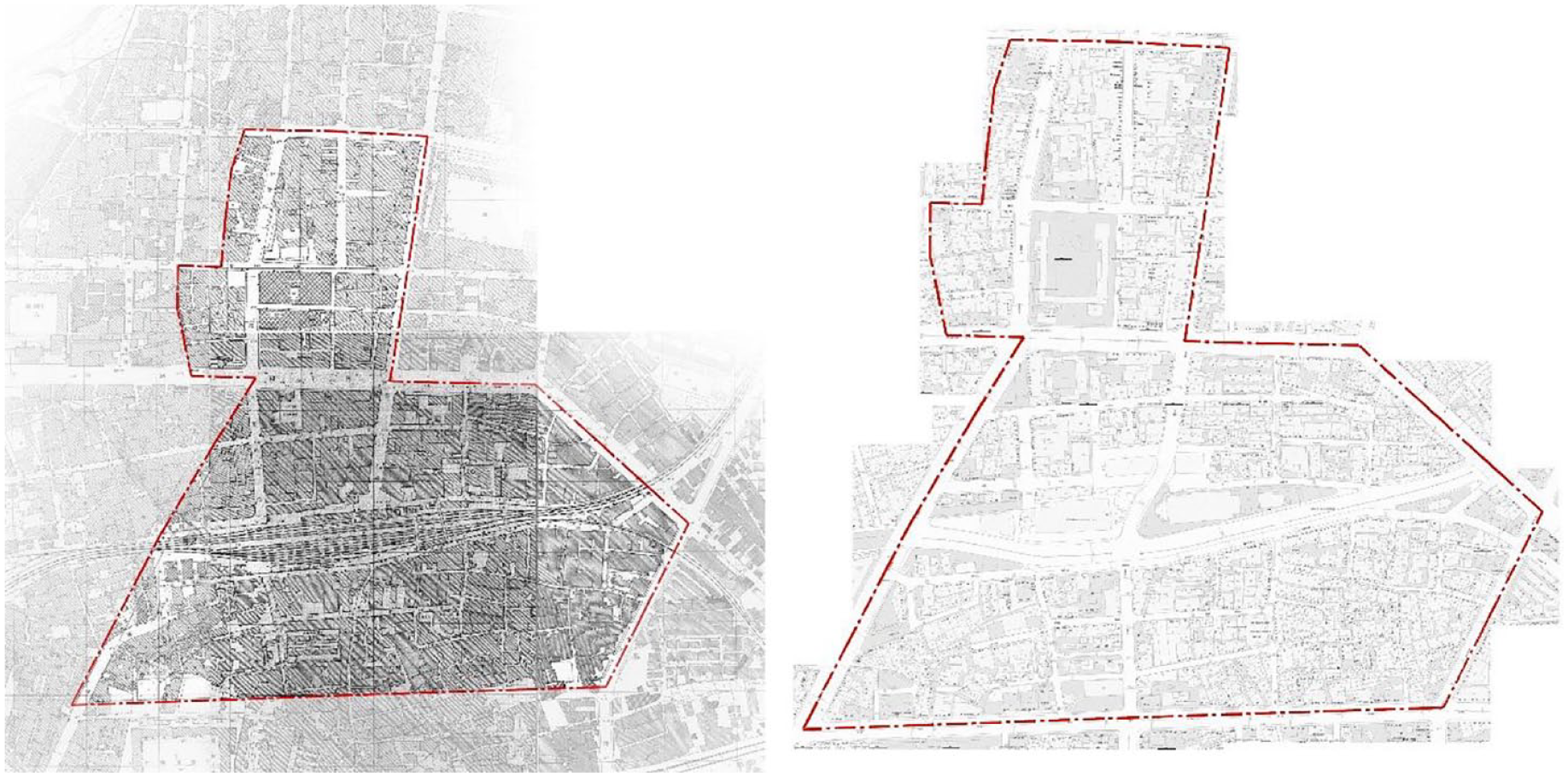
Wanhua Railway Station area in 1969 (left) and in 2007 (right).
Spatial changes in Wanhua Railway Station redevelopment area during the period 1969–2007.
Market-led equalization of land rights: Built-in mechanism for land subdivision momentum
The research team then searched the archives provided by the Taipei municipal government for the records of building use permits that applied to those land parcels undertook redevelopment (land parcels highlighted in Map 4), and registration of land titles for ownership of all land parcels. There were 2,247 land plots with the average size at 101.8 m2 in 1977. The number of land plots went up to 2,621 and the average size came down to 87.3 m2 in 1988 (Lin et al., 2018). This is bottom-up equalization of land rights. Voluntary land subdivision created additional 374 land plots to be shared with new owners, and the average size of land plots became smaller over 11 years.
Incessant land subdivision results in fragmentation of land rights in the setting of high population density, and thus high land scarcity, in Taipei. Fragmented land holdings make land assembly carry a high transaction cost, as combining land parcels is imperative for efficient area regeneration. Wanhua has already shown signs of physical and social deterioration (Jou, 2000), which tends to form a vicious cycle into further concentration of low-income households. Low-income households under financial stress are often tempted by inflated land prices to sell a portion of their land holding for cash much needed for family urgencies. Land subdivision ostensibly boosts equalization of land rights, but it actually creates unintended negative effects of social segregation. According to the observation of slums in Southeast Asia, land subdivision seems unstoppable in socially segregated and unprivileged districts because of poverty (Marcussen, 1990; Zhu and Simarmata, 2015). 2
Double-tragedy as a result of excessive equalization of urban land rights
Private land ownership is the norm in Taiwan. As at 2011, the total land stock held by the private owners was 123.3 km2, accounting for 45.4% of the total area of Taipei. Between the first quarter of 2000 to the third quarter of 2012, Taipei’s housing price index increased by 168.3%, while its total housing stock increased by only 11.9% (Lin et al., 2018). Housing supply lagged greatly behind the housing price increase, which suggested the sluggish land supply should cause inelasticity in housing supply. Constraints in land supply make land resources artificially more expensive.
According to Taipei’s urban renewal regulations, the minimum size of land parcels qualified for planning-coordinated area regeneration is 500 m2. The sizes of land parcels redeveloped in WRS redevelopment zone are between 282.2 m2 and 307.5 m2, smaller than 500 m2. Thus those land redevelopments are considered self-initiated. In spite of the suboptimal sizes, those redeveloped land parcels had gone through about three rounds of land assembly and it took 6.4 years on average. The sizes of those land parcels without going through redevelopment were between 70.5 m2 and 90.0 m2. During the period 1970–1988, redeveloped land areas only accounted for 25.1% of the total areas (Lin et al., 2018). Thus it is clear that regeneration of WRS zone has been hampered by the fragmented small land holdings.
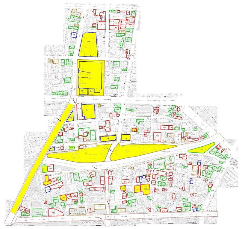
The research team conducted a spatial survey at the neighborhood level (see Map 5). Illegal construction is rampant, and open spaces are encroached upon. Planning control does not seem to work effectively as negative externalities become uncontrollable. Site coverage ranges from 26% to 98%, and plot ratio from 0.52 to 3.89. Continuous land subdivision gives rise to high site coverage. With economic and population growth, urban land becomes scarcer over time. In order to accommodate rising population, initial low plot ratio moves towards high plot ratio. The WRS redevelopment zone is becoming an extremely high-density district with high site coverage plus high plot ratio. Illegal construction degenerates the neighborhoods. Urban slums are in the making.
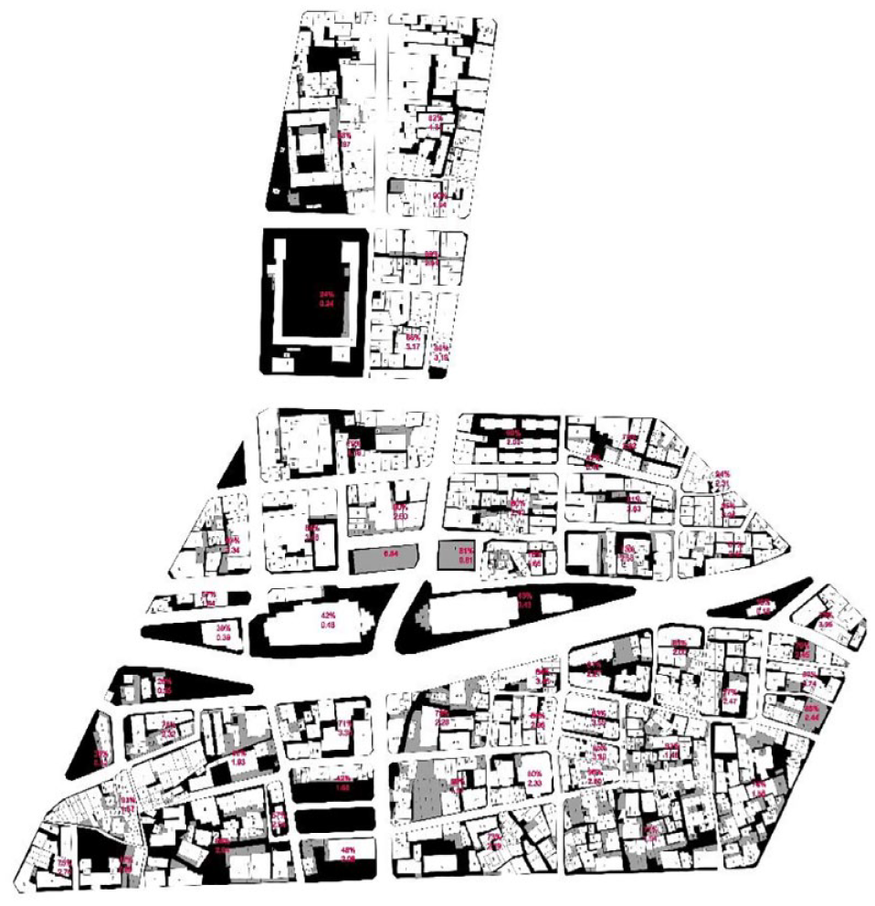
Site coverage and plot ratio of neighborhoods in WRS redevelopment zone.
There is a property rights situation known as the anti-commons, or practically known as the ‘hold-out’ problem, where multiple owners have effective rights excluding each other from efficient utilization of resources (Buchanan and Yoon, 2000; Heller, 1998). The onerous land assembly suggests high transaction costs incurred should prevent land assembly, if not make it impossible. Driven by heavy demand from people who need shelters, individual landholders carry out intensification of land use themselves on their small land plots in order to materialize the enhanced land asset value. In order to maximize the housing floor areas, private individual builders often ignore building codes and zoning, thereby imposing negative externalities on the neighborhood. Individual gains (maximization of housing floor areas) leads to neighborhood losses (loss of open and green spaces), as Map 5 has shown.
With aggregated negative externalities, neighborhood environment deteriorates. The neighborhood becomes the commons, another property rights situation where environmental amenities are over-consumed and land utilization becomes suboptimal. In contrast to the anti-commons, the commons is the case of open access to resources. Individuals seeking personal gain leads to depletion of resources as a result of overconsumption and under-investment, which harm the collective benefit, the so-called ‘tragedy of the commons’ (Hardin, 1968). The absence of planning control (demolishing illegal construction would otherwise make inhabitants homeless) constitutes the commons, which essentially deprives rights to other residents not to be adversely affected by developments in the neighborhood. Uncontrolled developments in the setting of high density result in substandard and inferior habitations.
The double-tragedy of the commons and anti-commons in the land development market of WRS redevelopment zone reveals the absence of an effective state in achieving sustainable urban forms. Clear land rights (residents not to be affected adversely by the neighbors) and effective development controls can contain the commons. Government regulations over land rights to curtail individual interests can avert the anti-commons for the sake of collective benefits (Zhu, 2017). The anti-commons in the land development market prevents optimal utilization of scarce land resources, and inefficiency exacerbates inequity. The double-tragedy constitutes a mechanism that creates a vicious cycle of continuous degeneration of the urban environment, worsening social equity between the current generation and future generations, and the city entrenched in an unsustainable mode (Zhu, 2012).
Conclusion
Equalization of agricultural land rights is about sharing land use value with the tenant farmers, though land asset value dissipation occurs as an unintended effect of perpetual use rights associated with farmland leasing. Equalization of urban land rights is meant to distribute land asset value equally among urban inhabitants. The progressive rates of land value taxation may have contributed to the equal holding of urban land, but incessant market-driven land subdivision, revealed by the study of the WRS redevelopment zone, has resulted in extreme fragmentation of land rights in the setting of Taipei’s high population density, though it seemingly enhances urban equality. Too-equal land rights give rise to a double-tragedy of the commons and anti-commons that sets the WRS redevelopment zone in a trap of uncontrollable deterioration. The consequent social segregation leads to inequality between urban neighborhoods. The intended equality evolves into actual inequality. Taipei’s CBD eastward movement from Wanhua to Zhongxiao and further to Xinyi has explained the difficulties in urban regeneration that is mired in anti-commons hold-out.
Footnotes
Declaration of conflicting interests
The author declared no potential conflicts of interest with respect to the research, authorship, and/or publication of this article.
Funding
The author received no financial support for the research, authorship, and/or publication of this article.