
Abstract
As an important component of China’s efforts at reform and its opening-up policy, China’s development zones have been experiencing rapid development for nearly 40 years and have played a huge role in promoting the country’s economic growth, industrial development, technological innovation and urban construction. This article focuses on the changing priorities and objectives of high-tech development zones and how they have shaped the spatiality of development zones. We also analyse the role of urban planning in delivering these spatial changes thereby expanding on the concept of planning centrality which was introduced by Wu in his 2018 article ‘Planning centrality, market instruments: Governing Chinese urban transformation under state entrepreneurialism’. By drawing on the case of the Optics Valley of China (also known as Wuhan East Lake High-Tech Development Zone), we illustrate how development zones have evolved spatially over 30 years due to the changing needs of the national government as well as the Wuhan municipality. We categorise these changes to the project’s spatial form into three stages: from block to park, from park to urban area, and finally, from urban area to new city. These three stages signify the different priorities of the Chinese state starting from industrial development, to land-based accumulation and now focusing on delivering an ecological civilisation and attracting and retaining a highly skilled workforce. For each corresponding stage, urban planning has played a crucial role whereby the change from a block to park was driven by regulatory and strategic planning whilst for instance the change from an urban area to a new city required planning to focus more on the delivery of high-quality public spaces and amenities through detailed urban design guidance and schemes.
Introduction
Large-scale urban development projects have become a major feature in Chinese urbanisation (Ren and Weinstein, 2013; Robinson et al., 2022; Shen and Wu, 2017; Shen et al., 2020). Chinese mega urban projects take on many different forms including new towns, mega-event led projects, regeneration schemes and as a specific policy area, so-called development zones, which are the focus of this article. Development zones represent an important institutional attempt to implement the strategic policies of reform, opening up and development that were put into practice in the late 1970s (Chien, 2008; Li and Yuan, 2022). Development zones have played an important role in the rapid growth of China’s regional economies and even its national economy. After nearly 40 years of rapid development, in 2018, China boasted 552 national development zones of various types (China Development Zone Audit Announcement Catalogue 2018). Among them, the national economic and technological development zones and national high-tech development zones have achieved a combined regional GDP of about 21.3 trillion yuan, accounting for about 24% of the national GDP, and their nearly 82,000 high-tech enterprises account for more than half of the country’s total of 172,000. The number of invention patents per 10,000 people in high-tech development zones is 57, which is five times the national average (11.5), and the number of invention patents per 10,000 people in economic and technological development zones is 72, which is 6.3 times the national average (Statistical bulletin on the national economic and social development of the People’s Republic of China in 2018; Statistical analysis of innovation and development of national high-tech zones in 2018; Assessment and evaluation of the comprehensive development level of national economic and technological development zones in 2019). Outstanding representatives of a number of national development zones include Zhongguancun Science Park in Beijing, Zhangjiang High-Tech Park in Shanghai, Suzhou Industrial Park, Optics Valley China in Wuhan, and Tianjin Economic-Technological Development Area. China’s development zones are not only the vanguards of China’s economic and industrial development in the past 40 years of reform and opening up, but also the promoters and participants of urban space development during the 40-year period of rapid urbanisation. Unlike the market-led mode of industrial park construction in the Global North, in China, the national will and the government-led nature of the construction and development of development zones are more prominent (Wu, 2018). However, whilst the role of the Chinese state in developing development zones is well known, most studies have focused on large-scale projects that have enjoyed interventions and policy support from the national government whilst bottom-up projects promoted by local governments are comparatively under-researched (Jiang and Waley, 2020; Shen et al., 2020; Wang and Wu, 2019; Zhang, 2017). This article seeks to contribute towards this knowledge gap by drawing on Wuhan’s East Lake High-Tech Development Zone, also known as the Optics Valley project. Our study charts how urban planning helped the Wuhan government align the mega project’s development over the last 30 years with the city’s evolving economic and strategic objectives. In particular, we shine light on the three different development stages of the Optics Valley project and how each development stage emerged and was shaped by changing wider economic and social conditions as well as the local government’s strategic vision for the city-region. Our study also illustrates the changing spatiality of development zones, evolving from enclosed and purely industrial parks to more self-sustained mixed used urban areas. Finally, this article summarises the successful experience of local governments in actively planning the development of development zones from the bottom up in the absence of national policy support; it makes constructive suggestions for government approaches to the construction of industrial parks in other developing countries. We also offer recommendations for future research on the government’s role and orientation in the construction and development of development zones.
Mega urban projects and the evolving role of development zones in China
Mega urban projects have been a salient feature across the globe. Whilst capital accumulation is the primary motivation to develop mega urban projects (Lehrer and Laidley, 2008; Orueta and Fainstein, 2008; Swyngedouw et al., 2002), more recent studies have uncovered that mega urban projects may be driven by multiple reasons including extra-economic objectives such as developing state housing (Meth et al., 2022), addressing social segregation (Harrison et al., 2019), enabling industrial upgrade (Shen et al., 2020), delivering critical infrastructure (Schindler and Kanai, 2021) and restoring a state-dominated urban order (Hsing, 2010; Wang, 2022). In urban China, mega urban projects have also become a dominant way of urbanisation and include new towns (Shen and Wu, 2017; Zhang and Wu, 2021), regeneration projects (Wang et al., 2022; Wu, 2016; Wu et al., 2022) and greenways (Chung et al., 2018; Zhang et al., 2020). Amongst the diverse range of mega urban projects, development zones have been particularly favoured by the Chinese state and played a significant role in attracting foreign direct investment and stimulating the economic growth of China (Cartier, 2001; Cheng et al., 2017; Wei and Leung, 2005). The development zone is a concept built on the experience of foreign export processing zones and high-tech parks. According to Li (2011), 1 a development zone is an area delimited by the government in a specific city, and it enjoys special management systems and preferential policies in various fields. Compared to many mega projects in the Global North that are developed through a public private partnership format, development zones in China are purely driven by the state, a development approach that is more prominent in the developmental Global South (Ballard et al., 2017; Goodfellow and Huang, 2021; Kennedy, 2015; Meth et al., 2019; Williams et al., 2022). According to Wu (2018), development zones have been developed in the context of state entrepreneurialism, whereby the state makes use of market instruments and its centralised planning to deliver urban growth. Land development under state entrepreneurialism can pursue multiple objectives including capital accumulation but also more strategic goals such as upgrading the industrial structure of a municipal region or enhancing social stability (Wu and Phelps, 2011; Wu et al., 2022). In practice this means that the state takes on multiple roles including the planning, financing, delivery and governance of development zones (Follmann et al., 2022; Robinson et al., 2021, 2022; Shen and Wu, 2017; Shen et al., 2020; Wang and Wu, 2019; Wu, 2018). Unlike industrial zones or free trade zones in many Global North contexts where they are formed spontaneously by relying on the presence of resources, the Chinese state is deeply involved in the management, investment promotion, planning and resource utilisation of development zones (Chien, 2008; Wong and Tang, 2005). Amongst the country’s many development zones, national-level economic and technological development zones and high-tech industrial development zones have been strongly supported by the government because of their large number, great contribution to economic development, large individual spatial areas, and obvious impact on urban space (Cheng et al., 2017; Chien, 2008; Yang and Wang, 2008; Zhang, 2015).
Development zones have also evolved in many ways since their initiation in the 1970s with regard to its governance, spatial characteristics, objectives and range of typologies. Whilst earlier development zones have focused almost solely on supporting the economy through industrial developments, since the late 1990s their objectives and resulting spatial characteristics have multiplied (Cartier, 2001; Cheng et al., 2017). Chien and Woodworth (2022) assert that development zones can be broadly divided into four categories including new Alpha cities that aim to be self-sufficient, middle class enclaves, techno-poles and themed cities. What these new types of urban projects share in common is that they no longer solely focus on industrial land development. Instead, they are multifunctional and include many urban functions including residential, commercial, and leisure land uses (Cheng et al., 2017; Chien, 2008). The motivation to develop multifunctional development zones is to generate economic growth through both industrial development but crucially also through urban consumption (Theurillat and Graezer Bideau, 2022). In addition to driving economic growth, development zones now also need to meet extra-economic objectives set out by the national government (Zhang and Gao, 2022). For instance, the national government has been trying to move away from China’s world factory model and to drive technological innovation through the development of high-tech parks such as Zhangjiang industrial park in Shanghai (Zhang, 2015; Zhu et al., 2022). The mushrooming of eco-projects also reflects the national government’s pursuit of eco-friendly developments whilst somehow preserving economic growth, which has been described as an urban sustainability fix (Chung et al., 2018; Zhang and Wu, 2021; Zhang et al., 2020).
The evolving spatiality of Chinese development zones
With the multiplying of types and objectives of development zones, their spatial characteristics have also diversified significantly over the years. For instance, studies have noted how the relationship between development zones and the core city has changed. Using geographic informational systems and grey relational analysis, studies find that most development zones have become the main driving force for the spatial expansion of the cities where they are located (Li et al., 2005; Wang et al., 2002). Others have examined the location types of development zones in their cities (Ma, 2014; Shen, 2003). Cheng et al. (2017) also observe that more recent development zones are developed along the edges of cities and share many similarities to edge cities found in the US. Drawing on 60 development zones across China and from different time periods as case studies, Hu et al. (2018) identified three locational types of development zones, each having a different relationship to the main city: the edge type, the outer suburb type, and the inclusion type (see Figure 1). Each type of development zone has also been developed following three modes of urban expansion, namely, axial extension, cluster growth or enclave jumping mode.
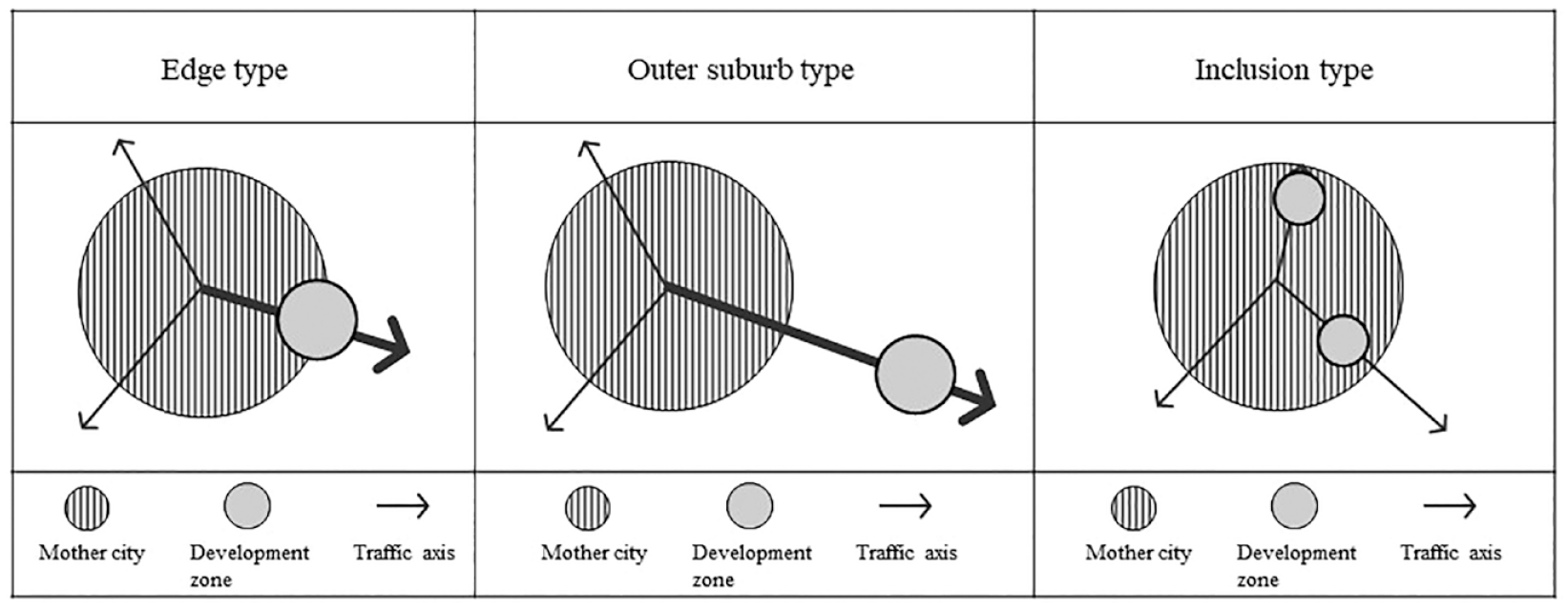
Three locational relationships between development zone and mother city.
Edge-type development zones retain a relatively close distance to the main city and are developed in the peri-urban areas of cities alongside an existing traffic axis that has been expanded. The axial extension mode is a common spatial growth path of edge-type development zones. Under the dual effects of the external expansion of the mother city and the development of emerging industries, the development zone spreads from the core resource cluster around the edge of the mother city to develop along the main transportation line or the axis of the direction of urban development. Finally, innovation and the shaping of new centres takes place, yielding growth on the main development axis (see Figure 2).
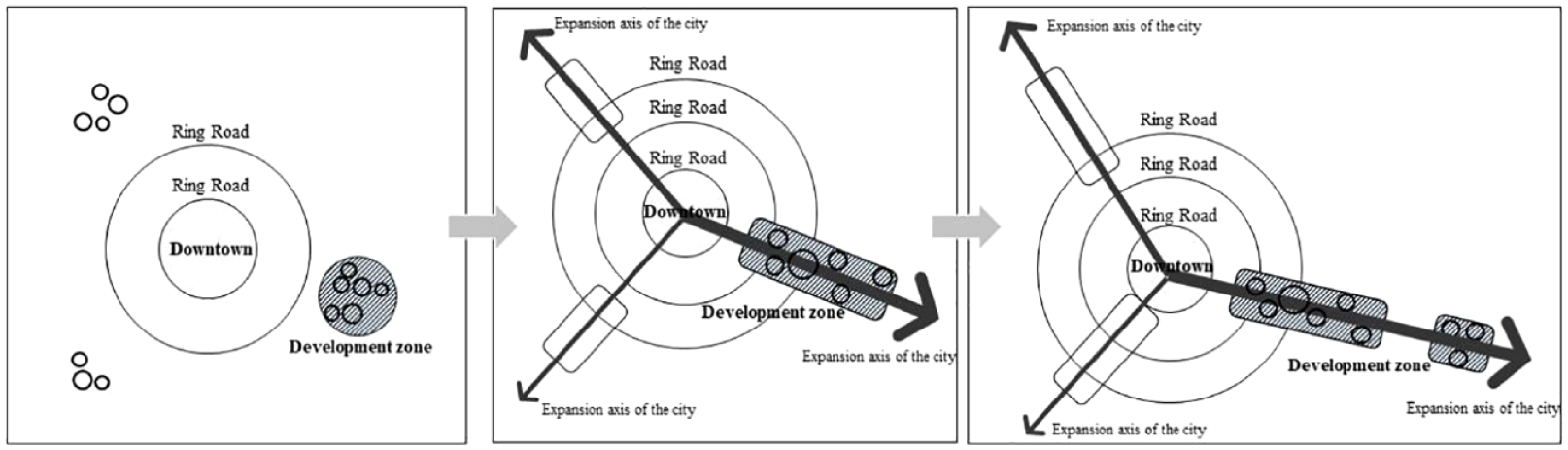
Schematic diagrams of axial extension.
Outer suburb development zones, in contrast, are situated much further away from the mother city, with much of the land between the main city and the development zone being rural land. The cluster growth type represents the spatial growth path of the outer suburb type; the development zone initially realises single-point clustering around outer suburban resources, then develops into multi-polar cluster expansion. Furthermore, development clusters appear near the regional traffic arteries that run between the mother city and the development zone (see Figure 3).
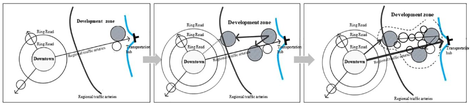
Schematic diagrams of cluster growth.
Finally, inclusion-type development zones are developed inside the main city, developed alongside existing roads. The enclave jump is a more common growth path of the inclusion type. In the early stage of development, the development zone shows point-like diffusion; then, enclave jumps occur along the main axis of urban development; finally, multi-directional enclave jumps of ‘one zone and multiple parks’ appear (see Figure 4).
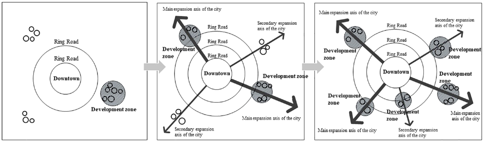
Schematic diagrams of enclave jumping.
The spatiality of development zones are influenced by their industrial and urban functions. Development zones which focus on economic and technological development usually appear in the outer suburbs of the main city. This is because its development goal is to introduce advanced foreign technology and management experience to form an industrial development cluster near the city. Therefore, this type of development zone generally favours a relatively isolated area with convenient external transportation, keeping a relatively large distance from the main city in order to be self-sustained (Sun, 2016). In comparison, high-tech development zones, which primarily aim to promote the transformation of scientific research into mass-production and to stimulate high-tech development, are generally edge types or inclusion types (Cai, 2013). This is because a high-tech development zone needs to be close to science and technological centres, which tend to be in the main city but also require abundant space for industrial development as well as good urban service provision and a balance of innovation, industry, urban services and other elements.
In the context of urban China, the state’s dominant role in developing mega projects is already well known. Existing research has also revealed the changing role of development zones and the diversification of its objectives (Cartier, 2001; Chien, 2008; Zhang, 2015). However, few studies have paid attention to the changing spatiality of development zones (Cheng et al., 2017 is a notable exception) and how these changes to the spatial patterns were facilitated through urban planning. The function of planning and how it has helped the local state to promote its projects and achieve its strategic goals requires further research in particular. More studies on such areas are thus required, as well as analyses of how local governments use planning methods, including organising planning, formulating planning strategies, applying planning results, etc., in the long term. It is in this way that government exerts its power to guide the spatial expansion of development zones. This article seeks to address this gap by discussing the evolution of the Optics Valley project over the past 30 years in relation to its changing planning priorities and its corresponding changes to its spatial patterns.
Methodology
This study draws on various kinds of data and insights collected from a multitude of sources over a period of three years since October 2019. The study first and foremost draws on the first-hand insights of the project gained by the first and second authors of this article, who have been involved in the planning of the Optics Valley of China project since 2015. During this period, the authors have participated in the development and production of multiple rounds of plans for the project. The authors also have insights into the day-to-day operations and governance of the project and have access to internal reports, documents and data. The two authors have either taken part in or have access to information related all the 175 planning projects that were developed as part of the Optics Valley of China since 1984. Furthermore, we conducted interviews with six individuals, including the former heads of the Planning Bureau and planning practitioners who work on the Optics Valley of China. Interviews took place between October 2019 and December 2020 and have lasted 30 minutes on average. In addition, this study also carried out archival research and has examined more than 30 official publications on the Optics Valley, such as ‘East Lake High-Tech Zone Chronicle’ and ‘China Optics Valley Record’, which are available from the archives of the Optics Valley of China, more than 60 books and more than 10,000 reports and news articles from the libraries of Hubei Province and Wuhan City related to the Optics Valley.
Introducing the Optics Valley project in Wuhan
Wuhan’s East Lake High-Tech Development Zone is referred to as the East Lake High-Tech Zone, also known as the Optics Valley of China, or simply as Optics Valley.
2
The project was first conceived to help China achieve its ambitions in technological innovation and meet the national government’s requirement for GDP growth. To do so, the Wuhan Municipal Government sought to build on its advantages in science and education and focused on collaborating with major science institutions of the city that have developed and produced China’s first optical fibre including the Wuhan Post and Telecommunications Research Institute, Huazhong University of Science and Technology and other university research institutes (Wuhan government senior planner, May 2020).
Wuhan East Lake Technology-Intensive Economic Community (the predecessor of Optics Valley) was therefore established in 1984. The motto of the Wuhan government was to work first and work on one project at a time until it has matured sufficiently. When the project is successful then promote the brand, and our achievements will be recognized and supported by the central government (Wang Qun, first secretary of the Wuhan municipal party committee, from Donghu High-Tech Zone Publishing Committee, 2015).
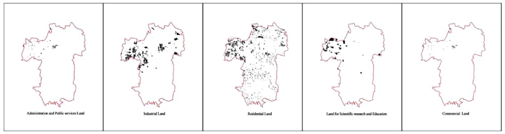
After more than 30 years of rapid development, the Optics Valley has become one of the most influential national-level high-tech development zones in China. The Optics Valley project is located in the southeast of Wuhan, a city in central China with a total area of 518 km2. Optics Valley’s eastern borders are on the administrative boundary of Wuhan next to the city of Ezhou in the Hubei province (see Figure 5). In terms of its typology, the Optics Valley is therefore a typical edge city development zone. In 2019, the population of Optics Valley reached 2.043 million, and those aged below 44 accounted for 77% of its population (East Lake High-Tech Zone Innovation Development Report, 2019). The population structure of Optics Valley is dominated by a young and highly educated working population. In 2019, the GDP of Optics Valley reached 187.677 billion yuan, a year-on-year increase of 10.2%. Specifically, the added value of high-tech industries reached 117.67 billion yuan, an annual increase of 21.6%, accounting for 62.7% of the regional GDP (East Lake High-Tech Zone Innovation Development Report, 2019). In 2019, the comprehensive strength of Optics Valley ranked fourth in the national high-tech development zone (Hubei Provincial Government, 2020). The leading industrial cluster of Optics Valley is its Optical Core Screen Terminal Network, which is China’s largest fibre-optic cable manufacturing base, optoelectronic device production base, optical communication technology research and development base, and laser equipment production base.
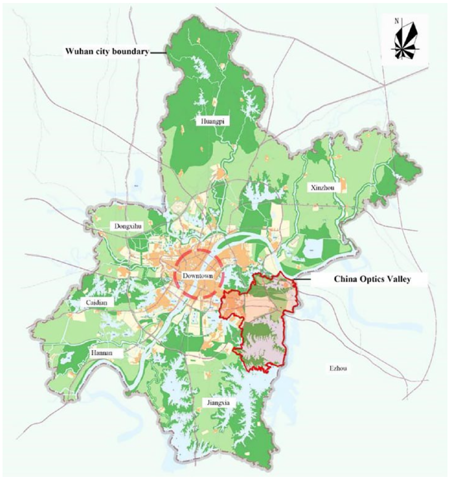
Location of Optics Valley in Wuhan.
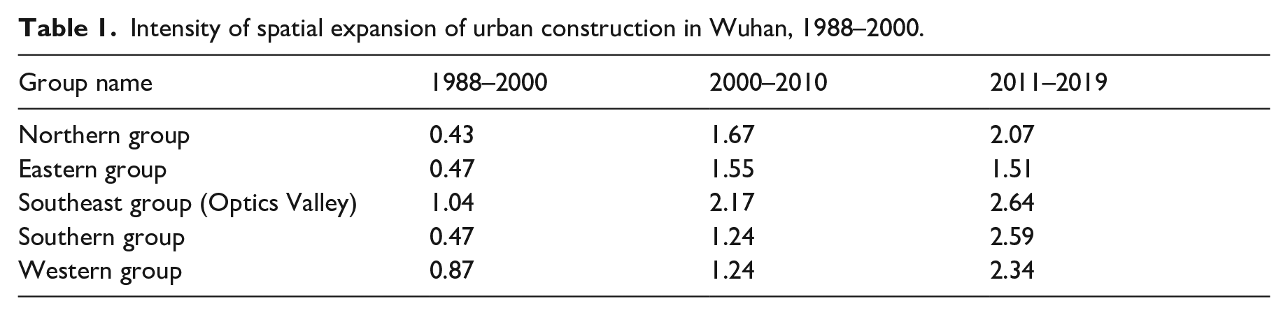
In terms of the project’s urban governance, Optics Valley is a governed by the Wuhan Municipal Government and the Hubei Provincial Government. The Optics Valley is governed by two state organisations, namely the Optics Valley management team (OVMT hereafter) which consists of provincial and municipal government leaders and the Optics Valley Management Committee (OVMC), according to the East Lake National Independent Innovation Demonstration Zone Regulations. The OVMT is responsible for dealing with major issues and liaising with national ministries and commissions whilst the OVMC is the de facto local government of the Optics Valley area and has all the administrative responsibilities and powers of the area. The OVMC is therefore also in charge of the development zone’s urban planning including (1) the preparation and approval of the land use plan and various national land and spatial plans in the Optics Valley; (2) the delivery of specific development projects and ensuring that the masterplan is implemented, including the development and construction of industrial parks and residential areas and the construction and maintenance of parks and other public facilities for culture, sports, medical care, elderly care, and delivery of local infrastructure such as road transportation and municipal facilities; and (3) the evaluation of the implementation of various Optics Valley plans and supervision and ensuring that planning objectives are completed on schedule. Planning centrality and state-oriented development are therefore the main features of Optics Valley’s urban governance. In this way, the local government has the sole authority to lead the spatial planning and construction of the development zone. In general, OVMC’s planning department would appoint an urban planning consultancy with relevant professional qualifications to carry out planning preparation and ensuring that the demands of the various developmental stages are met. This represents a concentrated expression of the local government’s professional research and judgment + problem response + government intention. Professional research refers to the analysis and understanding of the characteristics and trends of economic and social development at each stage whilst problem response means looking for solutions that can solve problems that have arisen or may arise at each stage. Government intention means that these solutions are generally implemented through planning, which is the expression of the will of the government. In terms of its spatial development pattern, the Optics Valley project follows the axial extension mode outlined by Hu et al. (2018). Overall, the project’s spatial evolution can be divided into three phases: block to park (1988–2000), park to urban area (2001–2010) and urban area to new city (2011–2020). Table 1 shows the rate of urbanisation of the Optics Valley over the three main periods of development compared to the urbanisation rate of other parts of Wuhan.
Intensity of spatial expansion of urban construction in Wuhan, 1988–2000.
The remainder of this article analyses the different objectives of the development zone and how they have influenced the morphology of the project and the preparation and the planning priorities at each of the three phases. It further reveals how urban planning was used to shape Optics Valley’s spatial development.
From block to park (1988–2000)
In the 1980s, China introduced a series of major reforms such as the opening up to foreign investment, implementing a tax-sharing system, introducing an urban and rural land use system, and the privatisation of housing. Pressure to produce economic growth also shifted to the local level. Local governments, in pursuit of GDP growth, participated directly in economic activities through direct investment, investment promotion and the establishment of numerous investment and financing platforms. At the same time, in light of the ‘reform and opening up’ context, local governments also sought to kickstart domestic research and development by supporting domestic universities and scientific research institutes. During this time, Wuhan’s government focused on collaborating and supporting key research institutes including Huazhong University of Science and Technology, Wuhan University, the Wuhan branch of the Chinese Academy of Sciences, FiberHome Technologies Group and other universities and scientific research institutes, which mainly focus on science and engineering. A large number of start-up enterprises were formed in the laser and other industrial fields, becoming the main force for the formation of the Optics Valley industrial system and the foundation for the spatial development of the Optics Valley. At this time, the land area of the Optics Valley was a mere 120 square kilometres, which is around 23% of the project’s current size.
Spatial development pattern
The reason why it was decided to develop the Optics Valley at the edge of Wuhan is because of its proximity to the city’s science powerhouses, which all congregated in one particular area of the city which the government dubbed the ‘new technology street’, as one Wuhan government official explains: The geographical location of Optical Valley originates from the ‘New Technology Street’. The municipal government has chosen this street to build Optical Valley because this street has gathered many colleges and universities, scientific research institutes, high-tech enterprises, and has a good scientific, educational and industrial foundation. (Wuhan government official A, May 2020)
Looking at Wuhan’s incremental land development from 1988 to 2000, it becomes apparent that the Optics Valley was the area with the fastest spatial expansion and the greatest intensity of growth in the main urban area of Wuhan during that period, thereby rendering it an important spatial growth node of the city. The project started from the ‘new technology street’ and gradually expanded along the main urban traffic roads in a point-like pattern. Luxiang Square, the easternmost downtown area of Wuhan, was the core of the project and development gradually moving east and southwards as can be seen in Figure 6.
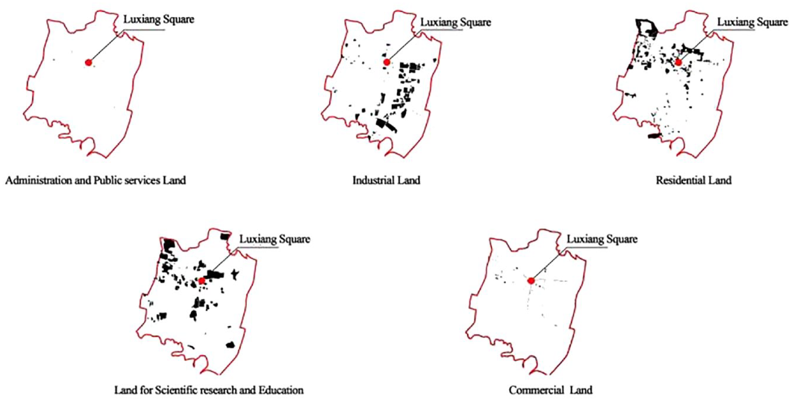
Distribution map of five types of land in Optics Valley (2000).
Role of urban planning
In its early stage of development, planning sought to develop the Optics Valley into a high-tech block and a leading area for R&D in the region. This included supporting universities and scientific research institutes’ innovative capabilities developing the scientific research industrial sector in the suburbs of Wuhan. During this rapid urban expansion of the development zone, however, problems such as scattered functional layout, a lack of overall planning and unplanned mixed land use functions emerged. The OVMC was also concerned that the development zone’s poor built environment quality, characterised by disorderly and dirty public spaces, did not match the high demands of a high-tech oriented development zone. The reason why the development zone suffered from these challenges in its early stage is because the Wuhan government was overly focused on developing the high-tech industry without considering how such rapid industrial growth might affect the built environment. In fact, at that time the OVMC’s planning was passive and reactive as existing spatial plans would only be altered if there was a new specific industrial project. There was no overall spatial vision for the development zone or proactive planning that sought to develop the zone in a more comprehensive manner. Planners noted that the industrial development speed during the project’s early stages far outpaced the speed of the OVMC to produce its spatial plans. To address these problems, the government later developed planning guidance at this stage in two ways. First, it created a regulatory plan 3 and a detailed municipal and road construction plan that met the needs of the industry and would gradually enlarge to the size of the park and ensured the rapid establishment of start-ups from launch to low-cost factory construction. Secondly, it implemented environmental renovation and transformation plans based on the intention to shift ‘from suburb to city’.
From park to urban area (2001–2010)
In the 21st century, with the acceleration of globalisation and China’s inclusion to the WTO, the central government also sought to change the national industrial spatial pattern by transferring many of the country’s China industrial sectors from coastal regions to the inland and from the eastern parts of the country to the central and the western parts of China. This overall strategy became one of the most important drivers for the Optics Valley development, which at that time was already an important industrial cluster of the central region of China. The Optics Valley was thus one of the key receiving areas of the domestic industries that came from the eastern coastal regions of China. Concurrently, the Wuhan Municipal Government further improved Optics Valley’s nexus of industry–university–research cooperation and continued to promote the development and diversification of innovation platforms and the specialisation of incubators. For the abovementioned reasons, the linkage mechanism of production, education and research in Optics Valley gradually matured, and the cooperation between production, teaching and research produced remarkable results, including many well-known, innovative enterprises with independent intellectual property rights and independent brands. Continuous innovation capabilities also emerged and attracted prominent high-tech companies such as Fiberhome Communication Technology Co., Ltd and Huagong Tech to the development zone. Driven by the influx of external industries and the improvement of its own scientific and technological innovation capabilities, the total industrial output value and the total income of Optics Valley increased significantly from 2001 to 2010 by 27.19% and 27.57% respectively (Statistical report of Wuhan East Lake High-Tech Zone, 2001–2010). During this 10-year period, the rapid development of the economy and industry and the increase of employment and entrepreneurial groups made Optics Valley the area with the fastest growing foreign population in Wuhan. The working population increased from 113,300 to 328,800, with an average annual growth rate of 12.6%. To ensure the development of Optics Valley’s industries and to meet the demand of the employed population for more land resources and comprehensive urban amenities, the Wuhan Municipal Government took the initiative and applied to the provincial government to expand the development zone’s territory. As a result, the development zone grew from 120 km2 to its current size of 518 km2.
Spatial development pattern
The Optics Valley’s development in the previous phase was characterised by a gradual expansion from point-like diffusion to axis agglomeration, and the intensity of its land expansion still ranks first in Wuhan (see Table 1). Optics Valley became the main axis of Wuhan’s urban expansion. The interior space is characterised by the coexistence of filling less developed interior areas and extending the outward axis along the main roads and scattered industrial parks. With the gradual improvement of the zone’s public infrastructure and amenities, Luxiang Square was at this stage built into an important transportation and public service hub in the eastern part of the main urban area of Wuhan. The urban space within Wuhan’s third ring road formed a multi-horizontal and multi-vertical network structure, with differentiated but connected spaces for living and production filling the area within the third ring road. The development zone also transformed from a peri-urban area, with many rural areas to a purely urban area. At the same time, the area outside the Third Ring Road continued to extend east and southwards along the city’s two main roads (High-Tech Avenue and Optics Valley Avenue). This expansion of the zone was again driven by the development of several research, industry and public amenity developments. At this stage the Optics Valley was gradually transforming from a single-use industrial park to a comprehensive suburban city (see Table 1, Figure 7).
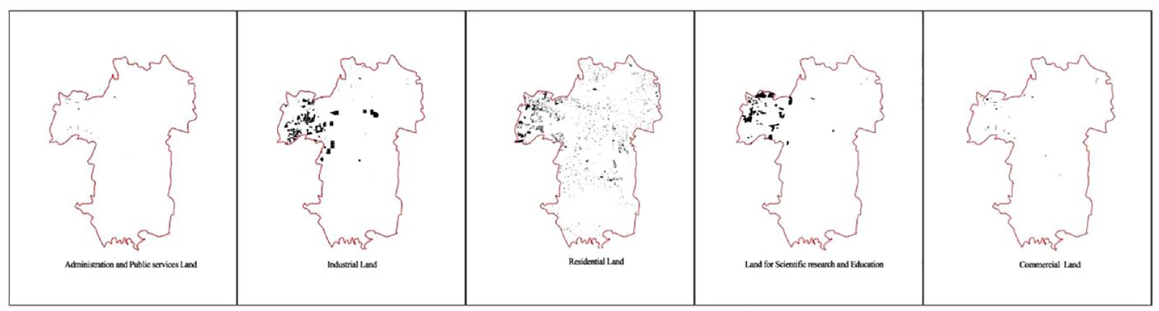
Distribution map of five types of land in Optics Valley (2010).
Role of urban planning
With the rapid development of the industry, the rapid growth of the population and the further expansion of the area under its jurisdiction, Optical Valley has gradually changed from a park to an urban area at this stage. The Wuhan Municipal Government also began developing a comprehensive and systematic plan that would transform the industrial park into a part of the city. The planning priorities at this stage included (1) how to develop the development zone into an area that is both conducive of scientific development and innovation whilst delivering a high-quality ecological spatial framework for production and living in the Optics Valley and (2) how to achieve greater intensity and efficiency of spatial resources to boost economic and social development. These two issues were the main problems facing the Wuhan Municipal Government at this stage.
To address these issues the government started developing a more comprehensive urban planning system. Optics Valley established a framework for urban planning in the form of master plan + special plan for public facilities + regulatory plan, and it innovatively proposed the idea of strategic planning + industrial planning + spatial planning to compile the master plan. In essence, this entailed the establishment of a special planning system that integrated strategic planning, industrial planning and urban planning, meaning that industrial developments were planned alongside the needs of the people who would inhabit the development zone. The masterplan also shifted from simplistic industrial planning covering aspects of culture, education, health, sports, elderly care and other public service facilities. At the same time, Optics Valley also ensured that the regulatory plan was strictly implemented and adhered to in order to serve the development zone’s land development and construction needs. During this stage of rapid development of the Optics Valley, the government’s planning behaviour was characterised by proactive urban planning, framework building and system building. This proactive planning approach was in stark contrast to the zone’s passive planning approach during its initial development stage.
From urban area to new city (2011–2019)
Following the slowing down of economic growth in China, the central government has also changed its development approach from rapid urban expansion to a slower urban growth rate that focuses on delivering high-quality development. The focus of economic, social and urban space construction in China has shifted from speed and quantity to quality. This has also deeply affected the transformation of the development mode of the Optics Valley. After its rapid expansion in the past decade, the ‘Optics Valley brand’ has become well known in China and has been favoured by many Chinese national development strategies. High-profile development and policy initiatives such as the National Innovation Demonstration Zone, China (Hubei) Pilot Free Trade Zone Wuhan Area, National Optoelectronic Information Industry Base, National Bio-Industrial Base and National Innovation and Entrepreneurship Demonstration Base have all settled in the Optics Valley. The Wuhan Municipal Government has continued to drive industrial innovation in the Optics Valley by expanding collaboration not only with universities and research institutes but also working with enterprises. The strategy has worked well and the government managed to attract major high-tech companies such as Huawei and Xiaomi to set up second headquarters in the development zone. Whilst innovative enterprises and its highly skilled employees are helping Optics Valley gradually move from the domestic to the global stage, they also have greater demands for high-quality urban spaces and tailor-made supporting services and amenities. Concurrently, with the central government emphasising the development of an ‘ecological civilisation’ and a ‘beautiful China’, the protection and utilisation of Wuhan’s ecology have also become top priorities. The Optics Valley’s goal for the achievement of high-quality development has at this stage become the protection and beneficial utilisation of its ecological space and the shaping of a new type of urban space suitable for the needs of its high-skilled and creative population.
Spatial development pattern
Since 2011, the spatial expansion of the Optics Valley has gradually slowed down. This is because the project’s territory reached the administrative boundary of Wuhan and there is no new space to expand. In addition, out of consideration for the protection of the ecological spaces of the city such as mountains and rivers, Optics Valley’s development now focuses on consolidated centre growth + discontinuous cluster growth. In practice, this means the improvement urban public services and enhancing the quality of public spaces. Major developments during this stage of the project includes the construction of public service facilities at the provincial and municipal levels, such as the Optics Valley Management Committee building, the Hubei Olympic Sports Center, Hubei Science and Technology Museum, Optics Valley Science and Technology exhibition Center, Hubei Maternal and Child Optics Valley Branch, and Wuhan Welfare Institute, amongst others. These public buildings are mostly situated in the central part of the Optics Valley and has accelerated the development of its central area and become a regional centre in the east of Wuhan. A functional and well-managed public service centre system comprised of both the main (Optics Valley town centre) and the secondary (Luxiang sub-centre) area has been formed, which has also comprehensively driven the development of facilities supporting various living and production needs in the development zone (Donghu High-Tech Zone Management Committee, 2021). The built environment quality has significantly improved, compared to the previous phase, as can be seen in Figure 8. To ensure that there is sufficient supply of land for industrial development whilst ensuring that natural ecological spaces are protected, the Optics Valley has started the construction of functional groups at the easternmost end and the northern and southern wings of Wuhan. It is worth mentioning that Optics Valley has also made some attempts to tap into the potential of built-up space at this stage, representing an attempt to meet the spatial development needs of industrial iteration through urban regeneration rather than urban expansion.
Distribution map of five types of land in Optics Valley (2019).
Role of urban planning
To ensure that the development zone complies with the current era’s new requirements for development, the spatial planning of Optics Valley at this stage focuses on two aspects, namely ‘precision’ and ‘pioneering’. ‘Precision’ refers to the fact that the objects of planning are more precise. Spatial planning focuses more on the needs and expectations of innovative companies and people in Optics Valley. Based on the production and lifestyle of its highly skilled population, the OVMC has produced a series of special plans for high-quality service facilities such as global ecological spaces, blue and green infrastructure such as water systems and greenways, technology incubators and developing the night-time economy. The key objective of ‘precise’ planning is to create a living environment that caters to the needs of the development zone’s high-skilled workers, to stimulate innovation and entrepreneurship and to enhance the happiness and sense of belonging of Optics Valley’s new population. ‘Pioneering’ refers to the OVMC’s attempt to gradually shift from land use planning and zoning towards more detailed planning of high-quality building spaces. There is now a much greater focus on urban design and place-making, emphasising creating three-dimensional urban spaces. All newly developed areas of Optics Valley at this stage are required to produce high-quality urban design schemes. Among these urban design schemes, the overall urban design framework of the Optics Valley central area is the most important and representative planning project. Based on the spatial characteristics of multi-element synergy under the banner of three-dimensional urban development and based on the urban design concept of being intensive, efficient and integrated, the development zone now makes more efficient use of the area’s above-ground space, ground-level space and underground space. The spatial model of the small neighbourhood and dense road network proposed by this project is exceptionally forward-looking and innovative in China.
Conclusion
There is a significant body of research concerned with the various roles of the state in delivering large-scale urban development projects across the globe (Follmann et al., 2022; Robinson and Attuyer, 2021; Robinson et al., 2022). In China it is now very well known that the state is the most dominant stakeholder in developing mega urban projects for both economic and strategic objectives (Wu, 2018; Wu et al., 2022; Zhu et al., 2022). The Chinese state does so by drawing on a state entrepreneurial approach that utilises planning centrality and market instruments (Wu, 2018). Development zones are arguably one of the most prominent and widespread form of mega projects that have been developed by the state through this state entrepreneurial model and have been used to meet the country’s push for economic growth, industrial upgrade and land-based accumulation model (Cartier, 2001; Cheng et al., 2017; Chien, 2008; Chien and Woodworth, 2022; Zhang et al., 2020; Zhang and Wu, 2021). Whilst studies now understand the evolving functions that development zones have had to fulfil for the state over the last 30 years, it remains relatively unknown how these development zones have changed in terms of their spatial characteristics and the vital role of urban planning practices in shaping their spatiality and urban functions. This study has sought to contribute to this research gap by drawing on the case of the Optics Valley in Wuhan.
Our study shows that the development of the Optics Valley project cannot be separated from the local government’s active involvement and leadership. In its initial stage, the Wuhan government was keen to follow the national government’s strategy of industrial development and solely focused on industrial innovation and manufacturing. This resulted in the Optics Valley taking on the form of an industrial park that was located close to existing research institutions but was otherwise largely cut off from the city. With the development zone’s rapid expansion, the industrial park was required to provide more urban amenities and housing for its growing workforce and the park gradually morphed into an urban area. This also enabled the city government to financially benefit from rising land values and the sale of residential and commercial properties. Finally, with the Chinese government’s more recent move away from land-based accumulation and the promotion of ecological civilisation and developing indigenous innovation, the development zone changed spatially yet again. It now focuses on delivering high-quality urban environments for its highly skilled workforce, high density and compact urban design that is less resource- and land-intensive.
The OVMC’s planning of the development zone has been crucial in delivering the spatial changes of the Optics Valley. The role and approach of the planning of the Optics Valley differed at each stage of the development zone. At the stage of shifting from block to park, the government completed low-cost local regulatory plans which could be quickly implemented, improved urban road systems, and built park roads, and changed zoning laws to support the rapid arrival of industrial projects and park construction, functioning as a surveyor in the early phases of urban planning. At the stage of developing from park to urban area, the government’s planning focused on determining a long-term development strategy, completing the preparation of special plans that provided public service facilities and detailed regulatory planning. Planning at this stage emphasised on achieving long-term strategic objectives, public service facility support and project implementation. During the stage where the zone changed from an urban area to new city, the government’s planning focused on delivering innovative, green and people-oriented concepts and detailed and high-quality urban design schemes in order improve the quality of the built environment and was conducive to attracting high-skilled workers, businesses and tourism. Through our case study, we find that in China, local governments use the preparation of spatial planning to guide the development of development zones, which has advantages and disadvantages. In terms of advantages, local governments use spatial planning as a tool to play a key role to promote the unified allocation of various resources. This means resources can be assembled very swiftly because planning is solely developed by the state. At the same time, however, we can see that the government interferes excessively in the market. The development and construction of the Optics Valley reflect the unilateral will of the local government. Targets and strategies are solely set by the state and do not receive sufficient societal and market evaluations and the entire planning approach lacks flexibility and fairness. Wu (2018) has highlighted the key role of planning centrality in China’s urban governance approach. In terms of this study’s theoretical contribution, we expand the concept of planning centrality. Our study shows that ‘planning centrality’ itself can contain a highly diverse set of planning practices that range from more flexible strategic zoning and regulatory planning all the way to detailed urban design schemes. Planning centrality is therefore not static but changes its approach depending on the need and the context of development.
Footnotes
Declaration of conflicting interests
The author(s) declared no potential conflicts of interest with respect to the research, authorship, and/or publication of this article.
Funding
The author(s) disclosed receipt of the following financial support for the research, authorship, and/or publication of this article: Funding for this project was obtained from the independent research project fund of the Wuhan Planning & Design Institute.