
Abstract
Developmental state literature almost completely neglects the fact that one of the unique features of the developmental state is its capacity to reorganize its territory, and the literature on the Chinese developmental state repeats the same oversight. Against this backdrop, this study attempts to retheorize China’s spatial planning from a developmental state perspective. In light of the theoretical discussion in this study, we argue that the developmentalist spatial planning has five main characteristics of the developmentalist spatial planning: (1) The state sees its territory as a means of production, not as a living environment. (2) Industrial location policies were market-conforming. (3) The spatial planning was controlled or strongly influenced by the elite economic agency that formulates industrial policies and guides the market. (4) The bureaucracy is more or less insulated from local growth coalitions. (5) Spatial planning creates rather than responds to economic changes. These five characteristics are apparent in China’s spatial planning as much as in South Korea’s.
Keywords
Introduction
The study aims to theorize Chinese spatial planning based on the reconceptualization of the developmental state. We claim that integrating spatial planning and economic planning is a key aspect of Chinese spatial planning. Such theorization contributes to the wider developmental state literature as well because the spatial aspects of the developmental state have been almost completely ignored.
Coined by Johnson (1982) to explain Japan’s economic growth, the developmental state concept was expanded to other fast-growing East Asian economies, i.e. Taiwan, South Korea, and Singapore, and, by the late 1990s, became a dominant theory on the role of the state in late industrialization. Various interpretations and reformulations of the concept exist, but the developmental state is essentially a state that has an economically rational long-term strategic plan for economic development and implement market intervention in a consistent manner under that plan. A developmental state differs from post-war socialist regimes, though both employ strategic planning for economic growth, because the former does not deny private ownership of the means of production. The developmental state also differs from a post-war Keynesian state, though both are heavy interventionist capitalist states, because the former’s intervention goal is fast economic growth rather than the maintenance of stable growth and social welfare. The developmental state was distinctive in the global south because it actively engaged in global trade while most others were building an independent economy through import substitution policies (Woo-Cumings, 1999: 182–199). All four developmental states listed above are authoritarian or pseudo-democratic, but whether a developmental state with a liberal democracy can exist is still an unsolved theoretical issue.
Today, the discussion continues around four separate, but related themes: (1) China as a developmental state (Baek, 2005; Breslin, 1996; Karagiannis et al., 2020; Lin and Zhang, 2019; Nee et al., 2007; Song, 2019; Szekely-Doby, 2020; Wu, 2015; Zweig et al., 2021); (2) developmental states as policy prescriptions for developing economies (Kayizzi-Mugerwa and Lufumpa, 2020; Mkandawire and Yi, 2014; Mohale, 2020; Oqubay, 2015: 374; Poon and Kozul-Wright, 2019; Tomkinson, 2019); (3) the collapse of developmental states and the neoliberalization of advanced East Asian economies (Bowles, 2020; Park et al., 2012; Sonn and Lee, 2015; Wade, 2018); and (4) retheorization of the developmental state from strategic relational and multi-scalar perspectives (Glassman, 2018; Glassman and Choi, 2014; Hwang, 2016; Sonn, 2010; Sonn and Hsu, 2022)
The original and the four more recent bodies of literature tend to overlook the spatial dimensions of developmental state’s policies. This is an important gap because the economic planning for late industrialization had to go hand in hand with spatial planning. We are not simply restating here that an economic growth model always includes a spatial dimension, an obvious fact considering the spatially uneven distribution of resources. Rather, we argue that a developmental state is unique in proactively manipulating the spatial distribution of these resources proactively by integrating spatial planning and economic planning, (i.e. ‘economic-cum-spatial planning’) and that such planning is one of the main characteristics that define the very nature of the developmental state. 1
Reinterpreting the developmental state through Lefebvre’s (1991, 2002) view of space and the developmental state, we will show why spatial planning on the district, urban, and national scales must be merged with the national economic plan in a state-led late-industrialization context. In so doing, we use examples from the spatial planning experience in South Korea and China. These two economies were chosen as examples mainly because of the huge difference in their physical sizes. Since the physical size of a country is likely to influence the way a state uses spatial planning, presenting the similarities that exist between the two countries, despite their extremely different physical sizes, can help us generalize the developmental model of spatial planning.
Spatializing the developmental state
The concept of a developmental state developed by Johnson (1982), Wade (1990), and Amsden (1989), among others, and was a critique of the neoclassical interpretation of East Asian economic growth. Neoclassical interpreters such as Balassa (1982) and Ranis and Fei (1975) argued that the role of the state should be limited to removing price distortions (i.e., getting the price right). However, developmental statists claimed that ‘the [developmental] state deliberately intervenes with subsidies to distort relative prices in order to stimulate economic activity’ (Amsden, 1989: 7) (i.e., getting the price wrong). According to Johnson (1982), a state is a developmental state if (1) it prioritizes economic growth over other goals, (2) its bureaucracy is more or less insulated from parliamentary politics and other political influences, (3) its intervention is ‘market-conforming’, and (4) it has a small elite agency that formulates industrial policies.
These main principles of the developmental state could be extended to the spatial dimension of a developmental state, as we will do in the latter part of this paper. The scarcity of previous attempts to do so is rather surprising to us because in the earlier decades, space was a usual part of discussion in development economics and development studies. Prominent economists such as Myrdal (1964) and Hirschman (1958) offered theories of spatially uneven development. Boudeville’s (1966) ‘growth centre’, which builds upon Perroux’s (1950) growth pole, was widely used in planning in France and elsewhere. Such spatial traditions were neglected in the academic discussion on the developmental state. .
Geographers and planners did notice the spatial dimensions of economic growth in East Asia but treated it in an ad hoc manner. Many find the literature on the developmental state useful (for example, Hill and Kim, 2000; Hsu, 2004; Lee and Tee, 2009; Park, 2008; Shin et al., 2015; Sonn and Shin, 2020), but their studies treat spatial policies as one of the developmental states’ actions and focus on the manner in which the characteristics of developmental states are reflected in urban and regional policies. They do not illuminate the fact that spatial planning constitutes one of the fundamental characteristics of a developmental state. In other words, geographers and planners were active in using the developmental state concept, but they did not make a sufficient contribution towards improving the concept. Sonn (2007) is one of the few exceptions, but he exclusively focuses on the political conditions of implementing spatial planning. He offers little explanation for the economic rationale for integrating economic and spatial planning, or why such integration is a necessary condition for a state to be defined as a developmental state.
In overcoming this limitation, we find theoretical inspirations in two theoretical sources: Lefebvre’s (2009) view of space as a means of production (see also Brenner, 2004; Smith, 2008; and Swyngedouw, 1992) and the scaling debate in human geography (Agnew, 1997; Brenner, 2001; Marston, 2000; Smith, 1984; Swyngedouw, 1997; Taylor, 1982). First, we explain how we use Lefebvre’s view on space as a means of production.
Since some of the key resources for economic growth are unevenly distributed across national territories, there is no growth model without implicit or explicit spatial dimensions. But some resources are more spatially bounded than others. Productive infrastructure such as industrial parks and transportation, energy, and water infrastructure, among others, are almost completely fixed on land and cannot be moved. How these means of production are spatially organized within the national territory significantly influences the productivity of the national economy. To put it more crudely, infrastructure of the right quality in the wrong location cannot be as efficient as the infrastructure of right quality in the right location. That is why Lefebvre considers space itself as a means of production. According to Lefebvre, the ‘spatial arrangement of a city, a region, a nation, or a continent increases productive forces, just as do the equipment and machines in a factory’ (Lefebvre, 2009: 188). This is because ‘the network of exchanges and the flow of raw materials and energy that make up space are also determined by space’ (Lefebvre 2009: 188).
It should be noted that the right location of infrastructure is relative to the location of other infrastructure. As such, the right location is more than just finding the right location of one piece of infrastructure, but reorganizing the relative locations of all related infrastructure in the country. In that sense, we agree with another argument that Lefebvre makes, the importance of the state in reconfiguring space as a means of production. He writes, ‘Only the state is capable of taking charge of the management of space “on a grand scale”. . .because only the state has at its disposal the appropriate resources, techniques and “conceptual” capacity’ (Lefebvre, 2002: 90).
We can further discuss the need for state intervention from scalar mismatch perspectives (Brenner, 2004; Smith, 2008). We can think of four scales with which to further discuss the scalar mismatch of ownership and deduct room for state intervention: firm, district, city and national territory. 2 Mismatch between private ownership at the firm level and the collective creation of agglomeration economies at the district level requires district planning. The scalar mismatch between the local production chain and the city as the spatial unit of labor reproduction requires urban planning. Finally, the scalar mismatch between production at the district scale and spatial division of labor across national territory requires national territorial planning. In the following sections, each of these mismatches within a late industrialization context as well as the role of the state are discussed with examples from China and South Korea.
National-strategic industrial park for creation and internalization of positive externality
The scalar mismatch between a firm and agglomeration economy
The first scalar mismatch to deal with is related to the scale of the agglomeration economy. The mismatch between a firm and the district is the source of agglomeration economies. These benefits arise when multiple firms in related sectors co-locate. (Dicken and Lloyd, 1972; 1990; Fujita et al., 1999; Hoover, 1937). Firms are some of the main contributors of the agglomeration economy, but they cannot claim ownership due to a mismatch between the scale of ownership and the scale of agglomeration economies. Agglomeration economies rise between firms, not within a firm. As such, a firm can take advantage of the agglomeration economy only when it is within the site of agglomeration economy. When a firm leaves that site, it loses the agglomeration economy that the firm has been contributing to. In that sense, agglomeration economies are internal to a district, but external to individual firms. When none of the contributors can claim ownership of the agglomeration economy, the one who owns the land might despite the fact that the landowner does not contribute to the agglomeration economy.
Theorization of appropriation of locational benefits in the form of rent dates back to Adam Smith (1776), although Smith discussed locational benefits in the context of land fertility not agglomeration economies. As much as the benefits of fertility improvement agricultural capitalists create can be appropriated by the rentier class, an agglomeration economy that is created by industrial capitalists can be. Such appropriation reduces the incentives for the capitalists to contribute to agglomeration economies, which, in turn, negatively impacts capital accumulation and industrialization of the national economy. This situation can change if agglomeration economies are somehow internalized within firms that contribute to the agglomeration economy.
Special Importance of agglomeration economy in developing economies
Agglomeration economies are important regardless of the level of development, but it is more so for late industrialization. The widening gap between the advanced and developing economies during the post-war period made exploitation of the agglomeration economies imperative in the late industrialization period. When Germany and France were catching up with Britain, the latter was not too far ahead in terms of general education level, skills, quality of life, and productivity. However, by the 1950s or later, when Japan and latecomer developmental states were industrializing, the advanced economies in North America and Western Europe were far ahead in every aspect (Amsden, 1989; Chang, 1999).
Furthermore, late industrializers had to compete against the advanced economies in a market already occupied by them. This problem was exacerbated due to the fact that the physical barriers to international trade were substantially overcome by means of cheaper transportation. Although international trade before World War I was as active as it was in the 1970s (Estevadeordal et al., 2003; Hirst et al., 2015; Sutcliffe and Glyn, 2019), trade in prewar times was limited to high-value, lightweight products. In the post-war period, trade was in heavy goods such as automobiles, machines, and even steel thanks to containerization in intermodal freight transport, the increasing size of freight ships, and automization of seaports. Nearly all products of late industrializers were exposed to international competition.
Protectionist trade policies that theorists of the developmental state put enormous emphasis on cannot completely remove this problem (Oqubay, 2015). If the products of a certain industry are priced higher than the international level, other industries using those products would not be competitive in the export market. State subsidies such as tax cuts and free offering of infrastructure can help, but the state’s financial capacity is often limited in resource-developing economies.
Developmentalist means of intervention
These are the reasons that agglomeration economies were important in the industrialization of developmental states, and the developmental state aggressively built industrial parks for these reasons. In a developing economy lacking natural resources, comparative advantage is usually based on cheap labor, which is abundant in big cities in developing economies. State-led industrialization often aims at economic upgrade rather than augmentation of existing comparative advantage. Industries of long-term strategic importance are formed and protected by the state. For these industries to sustain without comparative advantage at their initial stage, some other compensating factors should exist. Agglomeration economies can be one of the compensating factors.
State intervention can remove the possibility of appropriating the agglomeration economy by landowners through various means, solving the mismatch between the scale of ownership and the scale of agglomeration economy. If businesses are assured of such removal at a certain site, they are likely to be located in those sites. Through careful selection of the beneficiaries of these favorable conditions, the state can choose to co-locate certain firms, thereby creating agglomeration economies of certain types. When the gap between the land rent charged and the benefits of location increases, firms are even more likely to be affected by the state’s designation of locations. Thus, the state can, if necessary, locate economic activities at sites that do not match natural market outcomes.
Another effect of the state’s involvement in industrial park development was the assurance of other investors. When the construction of an industrial park begins, domestic businesses and foreign investors, assured of the state’s will, were less reluctant to get on board (Oh, 1996: 59–60). The state’s assurance of the project’s success was an especially important factor in investors’ decisions.
Industrial parks were not an invention of developmental states. Some argue that the origin is the UK, but they can be easily found in various countries (UNIDO, 2019). Even the earlier rural locations of the factory towns, including those of utopian sociologies such as Charles Owen’s phalanstery, were industrial parks. What distinguishes developmental states’ industrial parks from others is their strategic usage by the state (Sonn, 2019). Industrial parks were developed as a tool for the promotion of certain industries where the state is strategically important. For that reason, we will call these ‘national-strategic industrial parks (NSIPs)’. Examples of NSIP are ample in the history of developmental states. The Bupyong District of Inchon and the Guro District of Seoul in South Korea were developed by the state agencies in the 1960s (Sonn and Kim, 2020). Sino-Singaporean Industrial Park of Suzhou and the early development of Shenzhen are comparable examples from China.
Labor reproduction and new industrial city development
Scalar mismatch between an industrial complex and a city
The second scalar mismatch is between the NSIP and the city around the NSIP. The main production activities occur within the NSIP, but those activities cannot be sustained without the two types of ‘inputs’ that cannot always be produced within the park. They are urbanization economies and labor.
The supply of labor also requires a city because the labor power is often produced in cities. Workers and their families reside within the commuting distance of the industrial park, so their residences are scattered over a wider area than the NSIP. This area constitutes a city in which the daily and intergenerational reproduction of labor power occurs. The production and reproduction of labor requires a spatial unit because some of the infrastructure required for this process is spatially immobile. The daily reproduction of labor power requires facilities such as houses, leisure facilities, retail facilities, hospitals, and various other urban facilities. The inter-generational reproduction of labor power requires childcare, education, and training facilities. A city is a collection of all such facilities, which Castells (1977) called the ‘structure of collective consumption’. The state influences the location of those facilities through land use control, and provides the infrastructure required to support them.
Special conditions in latecomer economies
In a developing country where proper infrastructure is lacking, a firm’s economically rational choice of location is usually the biggest cities of the country because those cities have the best available infrastructure in a country relatively lacking in proper infrastructure. When firms are located in the biggest cities, workers are attracted to those cities for job opportunities. These two tendencies reinforce each other, and the biggest cities grow further, a process Gunnar Myrdal referred to as ‘cumulative causation’ (Lundahl, 2021; Myrdal, 1964). Adding firms and people to cities without sufficient infrastructure would cause negative externalities to outgrow positive externalities. As such, from an agglomeration economy point of view, it is important to create NSIP where the positive externality is bigger than the negative.
The location of labor force should also be considered. The discussion on the relationship between labor pooling and economic growth is abundant. (Faggio et al., 2020; Fujita et al., 1999). Such discussion, however, tends to focus narrowly on the availability of workers with the required skills. They also tend to assume that skilled workers are available somewhere in the country, so labor pooling is achieved by bringing them together. However, for new industries, the necessary skills might not yet exist. Therefore, an urban economy needs not only to bring in workers but also to transform them into certain types of workers that the industry needs (Storper and Walker, 1989).
The transformation includes not only the acquisition of new skills, but also the evolution of sociocultural qualities. Labor force must be disciplined with industrial ethics and have other capitalist workers’ qualities. This type of labor is almost ubiquitously available in advanced economies, where the modern education system instils general (as opposed to job-specific) knowledge as well as mental and physical discipline. However, such workers are scarce resources in developing economies with short histories of capitalism. Modern factory work is distinctly different from traditional peasant work in that the former is restricted in terms of time and space. Workers must be at a certain place at a specific time and must work for a certain number of hours. They must follow instructions and work in collaboration with many colleagues. In mechanized factories, the work rhythm is controlled by machines such as conveyor belts, not by workers themselves. All these characteristics of factory work require explicit external control over the human body until the requirements are fully integrated into the social norm and become cultural conventions. Economic transformation from primary to secondary requires not only urbanization of people, as Arthur Lewis (1954) discussed, but also the transformation of people themselves.
Furthermore, the daily and intergenerational reproduction of labor requires stable marriages and families. Considering this requirement, Henry Ford famously sent investigators to the homes of his automobile factory workers in the evening to confirm that the workers were home and not engaging in drinking or prostitution. This was also why Antonio Gramsci considered industrialization a wider sociocultural process (Camprubí, 2020; Gramsci, 1971).
Developmentalist means of intervention
Examples of industrial cities are ample in South Korea and China. In South Korea, a new city, Ulsan, was built to offer a living environment to families of workers who worked in the Petrochemical Industry Complex. Changwon was built for the mechanical industry complex. (Sonn and Kim, 2020). In China, Shenzhen was created to offer living infrastructure for workers who worked for foreign firms (Zhu, 1994).
Note that these South Korean and Chinese industrial towns are different from new towns in the United Kingdom and suburban development in the United States. Urban planning in the Anglophone tradition is a response to urban problems caused by economic change. In the 18th century, due to industrial development in cities and the enclosure movement in the countryside, cities became overcrowded and the idea of building new towns was born (Hall and Tewdwr-Jones, 2011). In contrast, new towns like Ulsan and Changwon in South Korea and Shenzhen, China, were built to host industries. Industries needed workers, and workers needed cities. In that sense, a new town was built as a tool to create economic change, and not as a response to it. In other words, new towns under the developmental state were proactive planning, while Anglophone new towns exemplified reactive planning.
Inter-regional division of labor and national territorial planning
Scalar mismatch between the site of industrialization and production of inputs
The next scalar mismatch is between the city of industrialization and the national provision of productive factors. The main site of industrialization is the strategically built NSIP, and labor reproduction is at the city scale. However, not everything is provided at these two scales, so industrialization requires changes in other parts of the national territory outside the site of industrialization.
Some of the inputs needed for production in NSIP are being produced or would be better to be produced in other regions of the country. Therefore, the creation of an NSIP always requires some changes in other parts of the national territory. Depending on the context, the changes in other parts of the territory may be minimal (e.g., a slight expansion of transportation capacity). In developmentalist economic-cum-spatial-planning, however, the construction of an industrial park was normally part of a bigger national territorial planning initiative and was therefore frequently accompanied by major changes in a wider territory. These inputs are transported to the NSIP through linear infrastructure. Just as various machines are connected through wires and belts through which power, raw material, and intermediate products are transferred, a production district must be connected to other regions through linear infrastructure such as water pipes, sewage, roads, gas pipes, and electric cables.
This does not mean that the developmental state is the only entity that uses Lefebvrian reconfiguration of the space. Firms locate their various divisions and branches in different locations, creating a spatial division of labor within the firm (Massey, 1987). Firms in the built environment sector provide other firms with the necessary infrastructure for such a spatial division of labor. Such infrastructure is given in response to the other firms’ spatial decisions and/or simultaneously influences their spatial decisions. The state takes part in this reconfiguration either through direct intervention or policies that influence private firms. This is common in all capitalist economies. Under the developmental state, however, the state’s share within Lefebvrian reconfiguration is larger because of the lack of huge capital investments required to manage large-scale infrastructure projects in the long run. In addition to this quantitative criterion, we propose and theorize two qualitative criteria: the state’s willingness to create regional disparity for the sake of Lefebvrian reconfiguration and the integration of spatial planning and economic planning. China and South Korea meet both these qualitative and quantitative criteria as discussed below.
Special conditions in late industrialization
Economies before fully-fledged spatial division of labor in production in national territories are well explained by the Ricardo and von Thunen’s logic of interregional trade. A region’s advantage is based on its natural endowment (Ricardo, 1817) and location (von Thunen, 1966), which determines what that region produces. The post-war economic order, or Fordism, is based on a reconfiguration of the national territory as an industrial production space. A Fordist economy entails an increase in the scale of production, mechanization, and a wider distribution of products. Thus, more intensive use of the national territory was required. The provision of transportation, water, energy, and other types of infrastructure integrate national territory into the production process, a change that we refer to as the Lefebvrian reconfiguration of territory. Similar to an industrial engineer who designs the layout of a factory, locating productive machines and support facilities at optimal positions, a territorial planner in a developmental state designs a map that shows the optimal locations of industrial parks, power plants, dams, expressways, railways, ports, and even cities.
Developmentalist means of intervention
South Korea’s First National Comprehensive Physical Plan (1972 to 1981), and China’s Coastal Development Strategy are examples of developmental states configuring national territory to make it a more efficient means of production. Those plans are drastically different from those in Western liberal economies.
In the 1960s and the 1970s, many Western Europe and North American countries followed national territorial planning, which some call the ‘Keynesian regional policy’. The primary aim of Keynesian regional policy was to reduce regional disparity (Brenner, 2004). Good examples include the actions taken by the Delegation for Regional Development and Territorial Planning (DATAR) in France that actively used the growth pole concept. In post-war Western Europe and North America, the growth pole was placed within an underdeveloped region, thereby reducing the gap between developed and underdeveloped regions within the national territory.
Because of the lack of physical infrastructure in a developing country, the national territorial planning in developing economies was different from that in advanced economies. Developmentalist territorial planning is not intended to reduce regional disparity to reconfigure the national territory into a more efficient means of production. This often involved creating regional disparity, which is contrary to the Keynesian regional policy’s aim, but consistent with Friedmann’s (1979) suggestion to concentrate the available resources in a small number of places where industrialization can take place. Deng (1986) in his famous quote from a TV interview said, ‘We permit some people and some regions to become prosperous first, for the purpose of achieving common prosperity faster’. China could afford this explicitness because there was general discontent toward equity-oriented economic policies under the command economy before 1979. The South Korean state, on the other hand, maintained that it was creating the second pillar of development in a balanced development of the territory. However, as shown in Sonn (2007), the First Comprehensive Physical Plan clearly indicates that the South Korean government was planning to concentrate available resources on the Southeast coast.
Conclusion
From a spatial viewpoint, the developmental state should have a tight grip on the entire national territory and reconfigure it as a means of production. Such reconfiguration is difficult because a premodern national territory is fragmented, not only in countries like China, where strong local pre-modern kingdoms and modern warlords existed, but also in countries such as Korea, whose territory is smaller and where there is a longer history of political centralization. In premodern national territories, with limited transportation and communication infrastructure, the availability of production goods differed greatly across spaces. Such resources had to be brought together for industrialization, which in turn, required the developmental state to integrate its territory.
Based on this discussion, we argued that the integration of spatial and economic planning is not one of the actions that a developmental state happened to take. Rather, such integration was a necessity that a developmental state could not do without (Table 1 summarizes our findings and arguments).
Developmentalist spatial planning at three spatial scales.
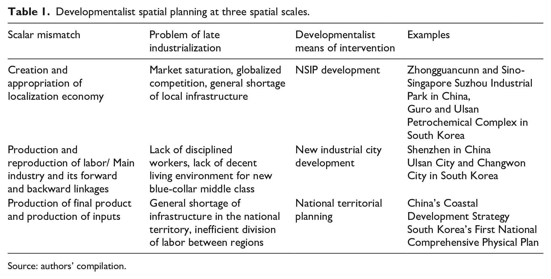
Source: authors’ compilation.
In light of the discussion in this paper, we can revisit the first and third elements of Johnson’s (1982) definition of the developmental state, which we mentioned earlier. The first element can be rephrased as ‘the state sees its territory mainly as a means of production’. We can rephrase the third element as follows: ‘industrial location policies were market-conforming’. While the state offered preferable conditions to selected industrial capitals, these conditions were facilitated through the allocation of private ownership or use rights. The state rarely relied upon confiscation or free allocation.
The other two elements of Johnson’s definition were not directly discussed in this paper and require further research. We can, however, speculate based on well-known anecdotal evidences. The second element can be rephrased as follows: ‘the spatial policy was under the control of or strongly influenced by the elite economic agency that formulates industrial policies and guides the market’. In the case of South Korea, the Economic Planning Board itself made important decisions about spatial planning. The Department of Construction, which was a spin-off of the Economic Planning Board, was heavily influenced by the economic planning and spatial planning decisions made by the Economic Planning Board. In the case of China, National Development and Reform Commission and its predecessors made almost all key decisions on national territorial planning as well as economic planning.
Concerning the fourth element, we can rephrase it as follows: ‘the bureaucracy is more or less insulated from local growth coalitions’. As Sonn (2007) partly covered, insulated from parliamentary politics with a centralized financial system, the state bureaucracy could navigate through the influences of local growth coalitions and make economically rational decisions in spatial planning. In China, where public finance was delegated to provincial governments, the state controlled the local governments and local growth coalitions by making them compete for the state’s support and by making local leaders compete for the good of the state, which in turn is critical for the survival of their political careers. Furthermore, As Deng’s (1986) statement quoted earlier in this paper indicated, Chinese people of that time were supportive of technocratic decisions in spatial planning for the sake of the economic growth.
In addition to these four elements, we would like to introduce one more, which is in contrast to spatial planning in the advanced capitalist economies. The additional element is as follows: ‘spatial planning creates economic changes rather than responding to economic changes’. This is the aspect that in this paper we called ‘proactive planning’ if we can call the mainstream planning ‘reactive planning’. Examples of ‘proactive planning’ are ample in studies on Chinese local entrepreneurialism and/or pro-growth coalition (Du, 2019; Wu, 2003; Zhang, 2002; Zhu, 1999). Wu (2015) is worthy of particular mention here. He presents how local governments’ high-tech industrial policy was used to facilitate land development at the local level, espousing a view that is compatible with that of the present paper. Through the concept of ‘proactive planning’, we would like to emphasize the national state’s intentions and its national industrial policy. In this study, we find that, despite the political and physical differences between South Korea (small-size, authoritarian centralized state) and China (continental-scale, party-state with a substantial level of fiscal decentralization) the aforementioned five elements of spatial planning are common in the two economies. The specific mechanism of its working requires further research. The fiscal decentralization of China made earlier researchers of Chinese economic development propose a ‘local developmental state’ (Blecher, 2008; Fang and Hung, 2019; Zhu, 2004). They argued that the developmental state in China exists not at the national scale, but at a local scale. Regardless of whether one agrees that the national government of China was not a developmental state, it is evident that the role of local governments in overall developmentalism was much more salient than in South Korea or other developmental states. However, China’s national-territorial planning seems to have many traits of developmentalist spatial planning.
Footnotes
Declaration of conflicting interests
The author(s) declared no potential conflicts of interest with respect to the research, authorship, and/or publication of this article.
Funding
The author(s) received no financial support for the research, authorship, and/or publication of this article.
1.
From an urban planning viewpoint, this mode of planning might be called ‘proactive planning’ in contrast to ‘reactive planning’. We call Anglo-American planning ‘reactive planning’ because it originated in reactions to urban problems caused by economic changes. Some of the origins of modern Anglo-American planning such as architectural regulations under the Poor Law and new town movements were reactions to extreme urban conditions into which the working class was forced. Unlike these reactions to economic changes, a large part of developmental states’ planning was about proactively creating positive change.
2.
Please note that ‘city’ is loosely defined here. Bigger than a district, ‘city’ is a shorthand for a subnational territorial unit, in which labor reproduction and economic activities beyond daily commuting occur. The size of the ‘city’ can vary depending on the socio-economic conditions of a nation. The city can be small, fitting the traditional definition of the city; that is, a contiguous built area. It can also be a city region, which is a constellation of multiple smaller cities that are adjacent to each other. Historically, the size of the ‘city’ has been growing, and the city region is becoming the normal functional unit of today’s globalized economy (Scott, 1998). In Chinese context, Yangtze River Delta, Pearl River Delta, and Jing-Jin-Ji (Beijing-Tianjin-Hebei) seem to be close to becoming city regions. The political project of the region making in those areas might accelerate the process (Li and Jonas, 2019; Li and Wu, 2018; Li and Yuan, 2022).