
Abstract
Prince Edward Island (PEI) is the smallest Canadian province and only island province in Canada. This small sandstone island has a lengthy coastline, of which nearly one-third is classified as sand dune, and over half on the northern shore facing the long reach of the Gulf of St. Lawrence. While scientific interest has focused on coastal erosion, the role of coastal dunes is less understood, and historical records are scarce. However, the boundedness and small size of the island has historically provided opportunities for mapping, with the exacting surveys of Captain Samuel Holland in the eighteenth century, Admiral Henry Bayfield in the nineteenth century, and comprehensive aerial photo analysis and topographic mapping in the twentieth century. Overlaying these sources in a Geographic Information System (GIS), and comparing them with additional historical maps and charts at the site of the first settlement around St. Peters Bay provides insight into the rapid and continuing evolution of the nearby coastal sand dunes, which can in turn be linked to key eras in the island’s 300 years of colonial history.
Keywords
Introduction
In September 2022, I presented my initial research question to my classmates in the Master of Arts in Island Studies program at the University of Prince Edward Island (UPEI): how can we maintain the resilience of the Island’s coastal dunes? Less than a week later, the storm surge from Hurricane Fiona removed an estimated 40% of the mass of our cherished dunes. With a crash course in environmental history and an introduction to the DUNES – Sea, Sand, People project headed by Joana Gaspar de Freitas, 1 my research question shifted to: what can we learn from past experiences in managing the dunes?
How does understanding the environmental history of coastal dunes relate to Island Studies, though? In the July 2023 issue of this journal, Romain Grancher called for a strengthening of the links between environmental history and Island Studies, noting that island examples ‘invite us to pay attention to the uncontrolled and unforeseen effects that human actions can have on island environments’. 2 Similarly, in their recent book, Entire of Itself, Milica Prokić and Pavla Šimková argue that island attributes such as boundedness, remoteness and vulnerability amplify environmental change. 3
Then there’s the coastal aspect of Island and Coastal Studies: islands just have a greater percentage relative to land area. Prince Edward Island, for instance, has only a total area of 5,600 km2, but over 3,000 km of coastline due to extensive bays and estuaries. 4 Of approximately 800 km of coastline directly bordering the sea (the Gulf of St. Lawrence or Northumberland Strait), over half of the Gulf-facing north shore is classified as dunes. 5 These dunes have played a significant role in the settlement – or lack thereof – on the north shore, and continue to provide little-recognized environmental protection to both humans and habitat.
Freitas makes a case for an environmental history of dunes in her 2020 paper of the same name, arguing that the results of the European transformation of dunes demonstrates that they are hybrid environments, requiring thinking across multiple domains. 6 With colleagues, Freitas further argues that ‘perceptions, ideas and policies are modelling agents of dunes as much as the wind, the ocean and the sand’, and these ideas carry throughout her recent book, A Global Environmental History of Coastal Dunes. 7 But while Prince Edward Island’s recent history has many parallels in the evolution of its coastal dunes, it differs from many of Freitas’ and the DUNE project studies in several ways: a much shorter colonial history, a legacy of British ownership, multiple political jurisdictions, a colder climate with (diminishing) winter pack ice, and minimal intentional coastal modification.
Answering my research question thus required a better understanding of how PEI’s coastal dunes – and people’s perceptions of them – have changed over time. While PEI is blessed with some comprehensive surveys, maps and aerial photos since the eighteenth century, there are significant gaps in the historical record that need to be supplemented with other records, given how rapidly sands shift. The St. Peters Bay area provides an illustrative example of the sources available, given the location of first and largest Island settlement at Havre Saint-Pierre, 8 and the unique parabolic dunes at the Greenwich sector of PEI National Park.
Methods and sources
Map collections
While a small island may not have been of much concern to the early European explorers, it has had the advantage of being manageable since the first days of the British surveyors. Many of the early maps held in the provincial archives have been digitized in the UPEI Robertson Library’s Island Imagined collection; the university’s GeoREACH lab 9 has in turn georeferenced significant orthophotos and surveys, providing a wealth of information about the evolution of the shore over the past three centuries.
There are few maps specifically of Île Saint-Jean, but more general maps of French possession identify the major bays and settlements, and local drawings from the eighteenth century add further insights. It is the comprehensive and (mostly) accurate survey by Samuel Holland in 1765 that demonstrates the features of the island less than a decade after the Acadian Deportation. 10 While subsequent maps were updated with new roads and communities, the coastline on these maps remained that of Holland’s original survey until the mid-1800s.
The primary surveys of the nineteenth century were the nautical charts of Captain Henry Bayfield, who surveyed much of the east coast of North America in the century’s middle decades. 11 Subsequent surveyors and mapmakers based their coastlines on Bayfield’s surveys into the early 1900s, although Meacham’s comprehensive 1880 Atlas 12 implies an alternate survey.
Twentieth century technologies
The boundedness of the island also proved beneficial for conducting complete aerial photo surveys, starting in 1935, with detailed topographic maps subsequently produced by the Geological Survey of Canada. Orthophoto sets were also created for the 1968, 2000 and 2020 aerial surveys, and photo sets (not geo-rectified) are also available for 1958, 1974 and 2010.
But given how quickly a sandy coast can change, there are still significant gaps in this record, particularly in the first half of the twentieth century. Construction drawings for harbour works in the government archives, covering the period 1910 to 1955, demonstrate that the first half of the twentieth century was significant for coastal construction and illustrate how the coastline – and coastal dunes – changed as a result.
Background
Prince Edward Island lies in the southern Gulf of St. Lawrence, separated from New Brunswick and Nova Scotia by the Northumberland Strait, 13 km from the mainland at the closest point. With only the low-lying, sandy Magdalen Islands between PEI and the coasts of Newfoundland and Labrador, northerly winds and waves have a 300 km fetches over which to form (Figure 1). 13
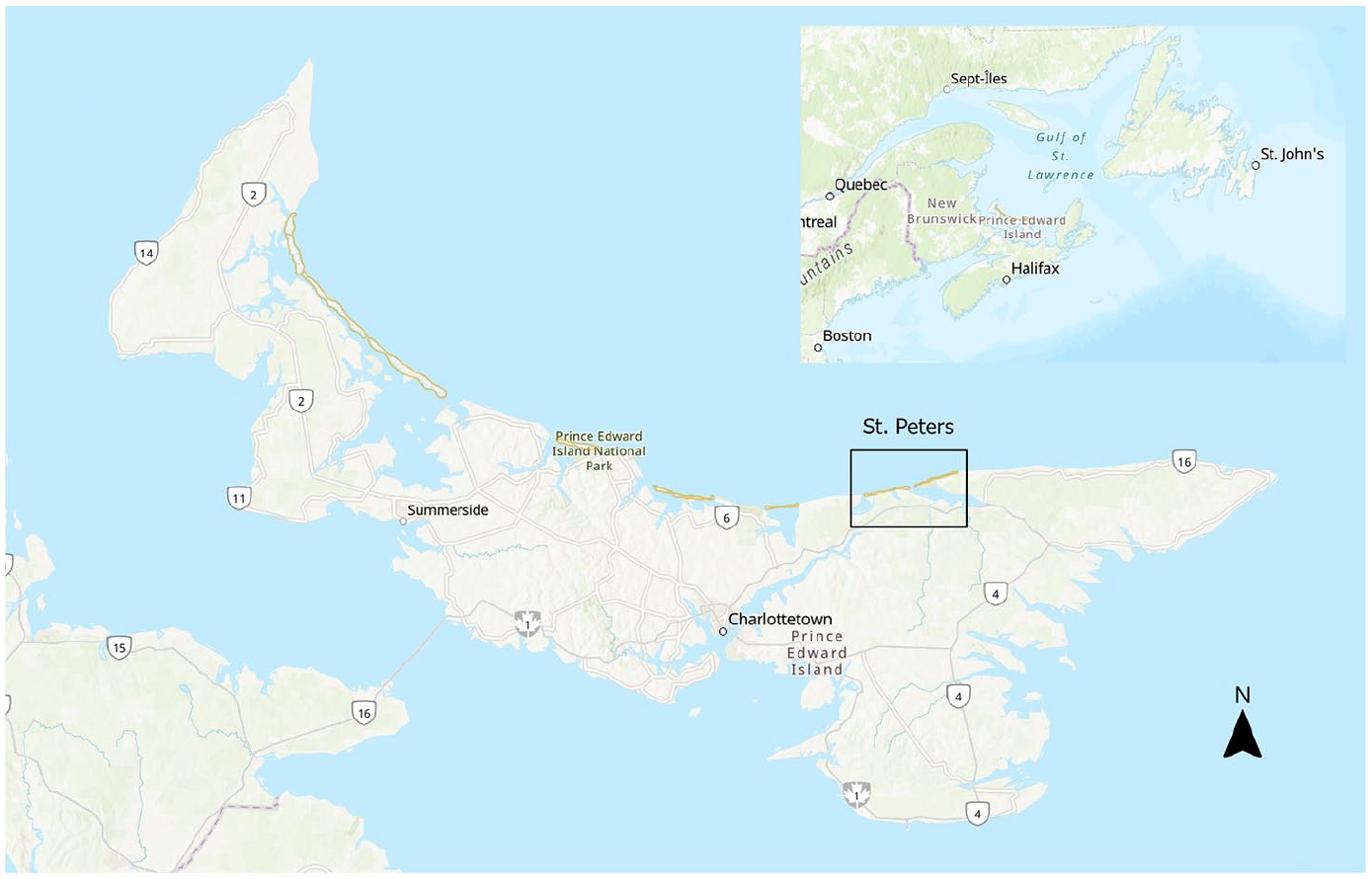
Prince Edward Island in the Gulf of St. Lawrence, with area of study marked.
While the island geology is primarily sandstone and shale, it is the iron-rich ‘sedimentary redbeds’ and resulting red soil for which the island is primarily known, although a prevalence of quartz on the beaches and dunes make them seem lighter in colour. 14 In 2002, scientists suggested that the original coastal dunes were domes, gradually followed by parabolic dunes formed by northwest winds – lagoons, marshes and forest cover prevented inland migration of the dunes, leading to transverse dune complexes. 15 On the dunes, the dominant vegetation was – and still is – native Ammophila brevigulata (American beachgrass or marram grass), with successional species on the lee slopes. 16
PEI’s climate – ‘cool temperate with a strong maritime influence’ 17 – could be considered a contrast to the stereotypical dunes in warmer climates or bordering open oceans. While hurricanes and the resulting storm surges are increasing along the Atlantic Coast in intensity and impact with climate change, 18 a gradual decrease in winter sea ice coverage with global warming is allowing northerly winter storms to increasingly pound the shore. 19 Coastal conditions such as longshore drift and sea level rise also impact the PEI coast, influencing the resilience and migration of the dunes. Although PEI is microtidal, with a range 1 m on the north shore, storm surges can double that. 20 Longshore drift on the north shore generally moves west to east, but varies locally, 21 influencing both the sediment supply to the dunes and the likelihood of sand hazards along the coast.
At the St. Peters Bay study area, a line of dunes runs from St. Peters Lake to the former St. Peters Harbour on the west side; to the east, a line of foredunes encloses rare parabolic dunes at Greenwich point, now part of PEI National Park. Early maps and charts indicate a barrier island that migrated and became part of the shore over the course of a century, while more recent historical maps, air photos, and engineering drawings show that few of the current dunes are natural formations, and most didn’t even exist a century ago.
Tracking Coastal History at St. Peters Harbour
The colonial history of Prince Edward Island (Figure 2), like much of the Americas, is more recent and more compressed than Western Europe. For millennia, following the retreat of the Laurentide Ice Sheet, the island has been the ancestral territory of the Mi’kmaq Nations, known as Epekwitk; PEI’s colonial history and written record only begins with the arrival of the French in 1720. While there are parallels with the impacts of agriculture and deforestation on coastal dune formation, this history has led to different challenges in facing the current climate crisis.
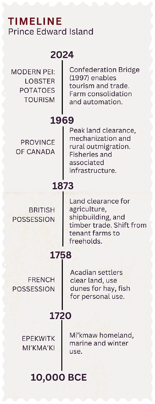
Significant eras in PEI/Epekwitk history.
Eighteenth century
The first settlers considered the sand dunes and coastal marshes as prime real estate for pasturing animals and gathering winter hay on an island that was largely treed. 22 Although the majority of the French and Acadian settlers were deported from the island by the British less than 40 years later, 23 Island historian Andrew Clark concluded that, ‘the French settlers had widely tested the fisheries, the timer, and the soil [across the island], cleared hundreds of acres of woodland, and had been responsible for the accidental burning of many thousand more acres’, in addition to leaving names on the map, and animals, seeds and weeds that would affect future settlers. 24
By virtue of its size and importance, Havre St. Pierre features on many of the early French maps (Figure 3). A sketch map, likely from the 1740s, is the earliest illustration of a barrier island to the west of the bay, as well as a road connecting to the then-named Rivière Port La Joye (unlabelled, centre).
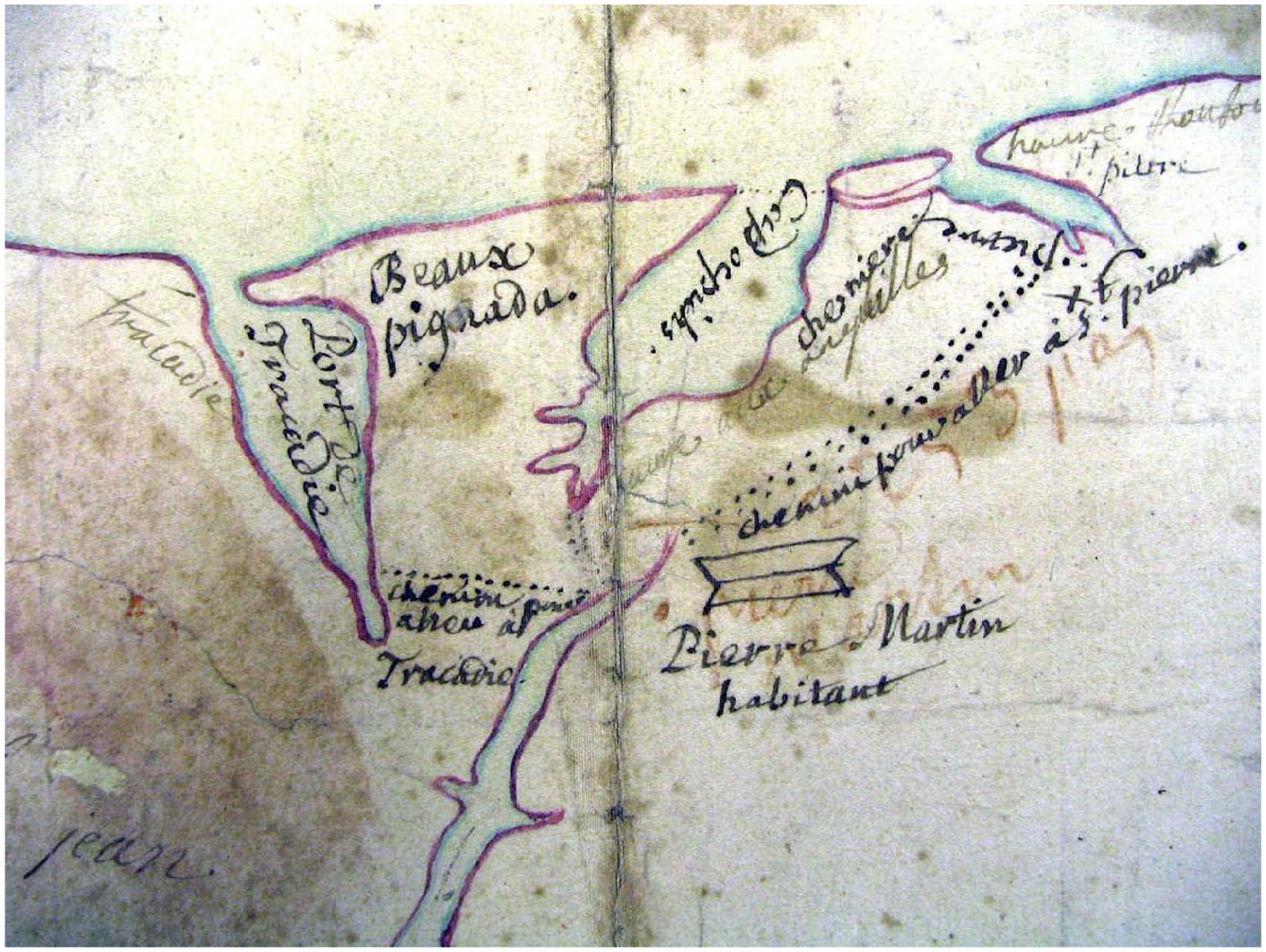
Extract, Anonymous, The d’Arrigand Map, 1713 (likely later). PEI Archives and Records Office, map 0,547.
Samuel Holland’s detailed 1765 survey reveals the state of the island shortly after the deportation (Figure 4), clearly illustrating both settlement and sandhills on both sides of St. Peters Bay, with a barrier island stretching from the west side across now-St. Peters Lake.
From Holland, Samuel and Charles Pettigrew. A Plan of the Island of St. John in the Province of Nova Scotia. 1765. Library and Archives Canada.
Nineteenth century
The attitudes of the British towards their new possessions influenced both the evolution of the coast and our ability to manage coastal change today. The detailed survey conducted by Holland resulted in 67 townships or ‘lots’, granted to supporters of the Crown. But these land grants would leave little public lands or coastal access, aside from an inconsistent application of a 500-foot fishery reserve along the coast. 25 For the settlers, it was farming, not fishing, that paid the rent; 26 like the Acadians before them, they valued the marshes and dunes along the coast for their fodder and pasture. 27
Henry Bayfield’s mid-century survey of the Gulf of St. Lawrence reflects the low value assigned by the British to the north coast of PEI, with only Richmond (Malpeque) Bay warranting a detailed chart (Figure 5). 28 The placement of lines on this chart of the north-east coast implies that most of the barrier island on Holland’s chart had indeed merged with the coast only 80 years after Holland’s survey.
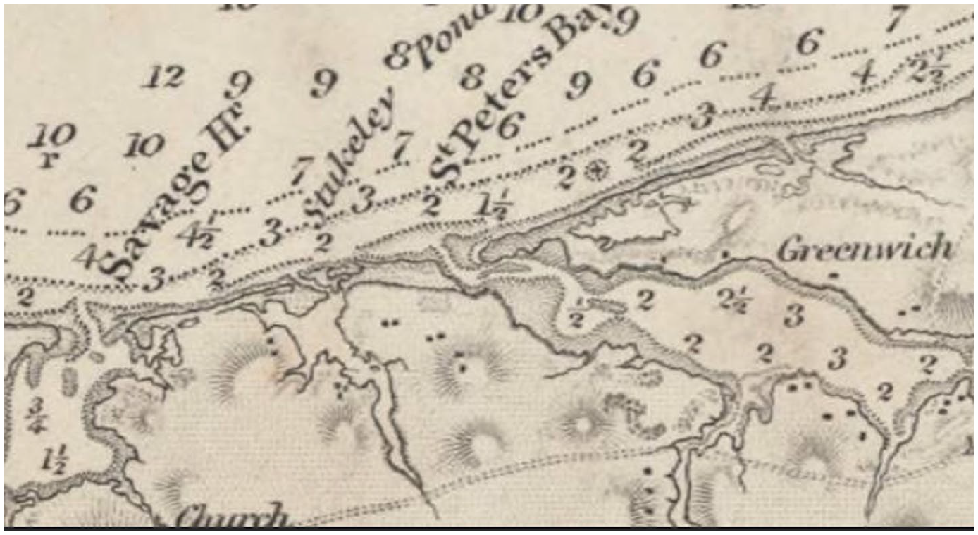
From Bayfield, Henry W. The Gulf of St. Lawrence. Sheet IX, eastern part of Northumberland Strait. London: Hydrographic Office of the Admiralty, 1845. McGill University Library.
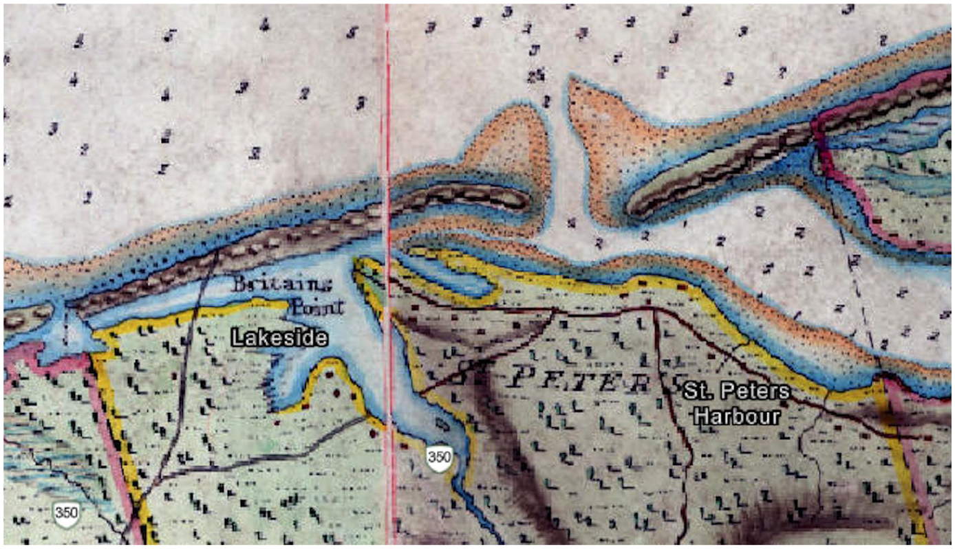
By the time PEI became a province of Canada in 1873, the coast, including the marshes and dunes, was largely in private hands, and the Crown had abandoned its claim to shore above the high-water mark. 29 The parallel rise of the lobster fishery now required infrastructure, with lighthouses to guide the way through sandbars, breakwaters to deepen harbours and lobster canneries strung along the shore. 30 Sand became a drawback, rather than a benefit (Figure 6).
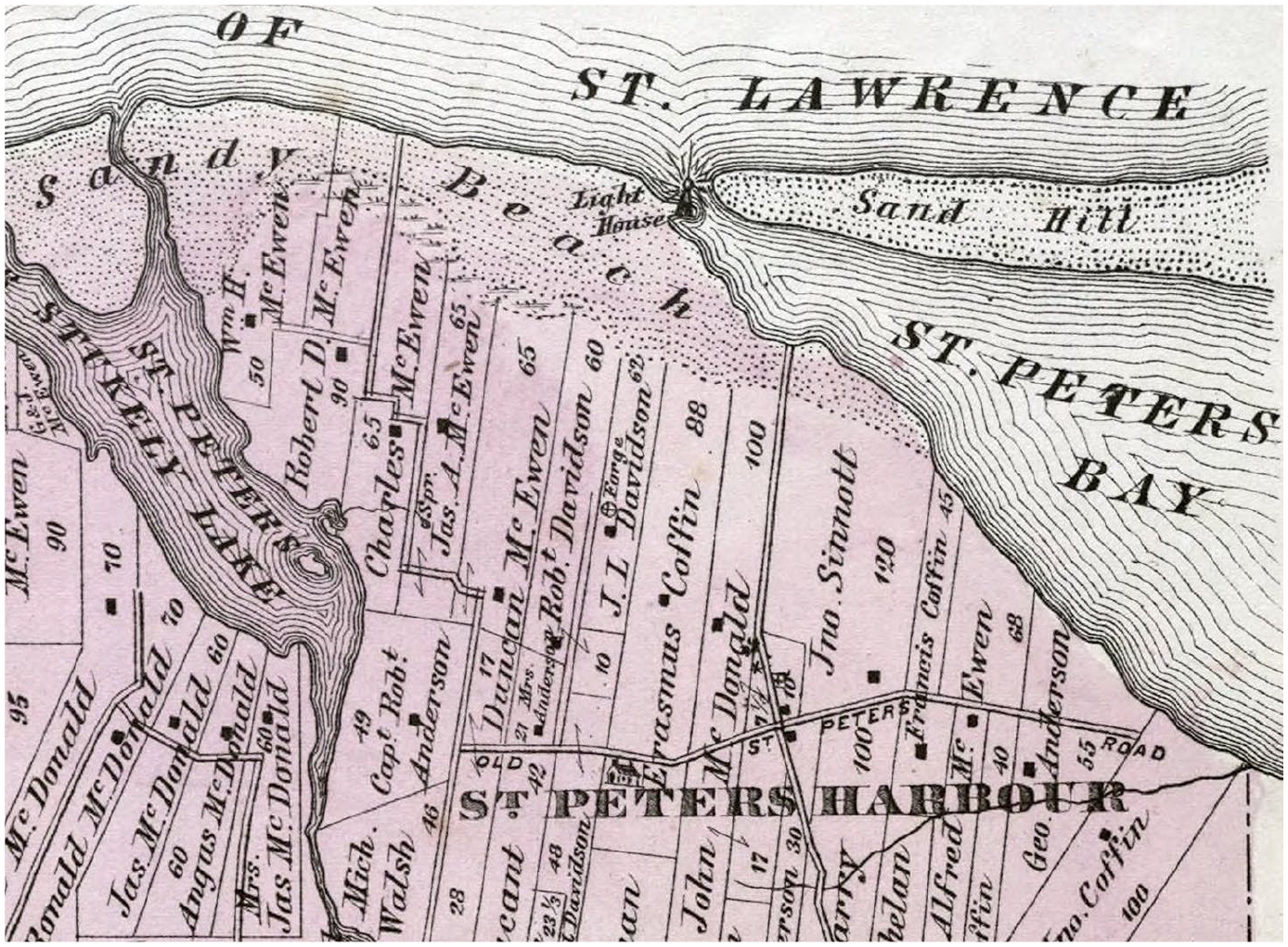
From Allen, C.R. Plan of Lot Thirty Nine: Kings Co., P.E.I. Philadelphia, PA: J.H. Meacham & Co., 1880. Atlas Map, 98.
In Meacham’s 1880 atlas, the topography west of the bay is labelled ‘Sandy Beach’, implying that there are no longer any dunes on this stretch of shore – this may have been a mapmaker interpretation of their relative significance, but given the recorded storms, 31 this may have also been an accurate representation of the state of the coast at that time.
With increased population pressure, 32 land clearance for agriculture, a growing shipbuilding industry, and increasing demand for wood, the island changed rapidly over the nineteenth century: 33 by 1900, over two-thirds of the Island’s original forest cover had been removed, and the remainder had been drastically changed through harvesting and fire. 34 So while European countries were implementing afforestation schemes, 35 colonial PEI (and much of Canada) was still focused on deforestation, creating a denuded landscape that provided increased sediment to the ocean and allowing the dunes to move inland. 36
Twentieth century
Engineering works started in earnest along the PEI coast in the late 1800s, but few maps or records are available before 1910. A 1913 engineering drawing for St. Peters Bay documents sand beaches at the mouth of the bay, sand hills to the east at Greenwich, and breakwaters on either side of the channel (Figure 7).
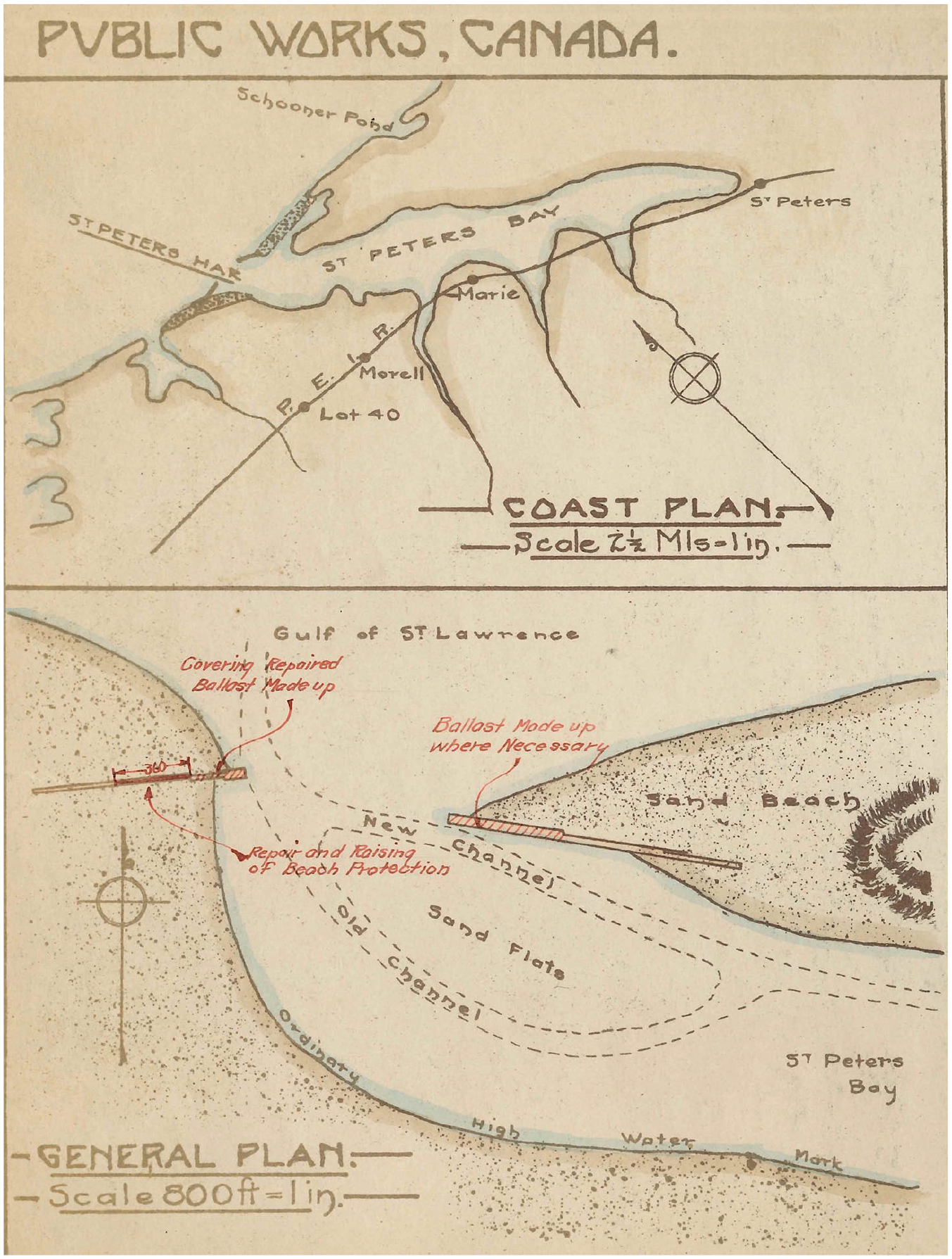
From Department of Public Works Canada, District of Prince Edward Island, St. Peters Harbour, Kings County, [1913–1914].
There is a gap in the public record, though, until the first aerial survey of 1935, which shows a new channel between the eastern breakwater and the Greenwich sand hills, a 1919 breach that was only reflected on historical hydrographic charts (Figures 8 and 9). 37 Less than a decade later, the old harbour had been largely abandoned, and engineering attention turned to preventing further breakthroughs and closing the old channel using sand fences.
St. Peters Harbour, PEI, 1935.
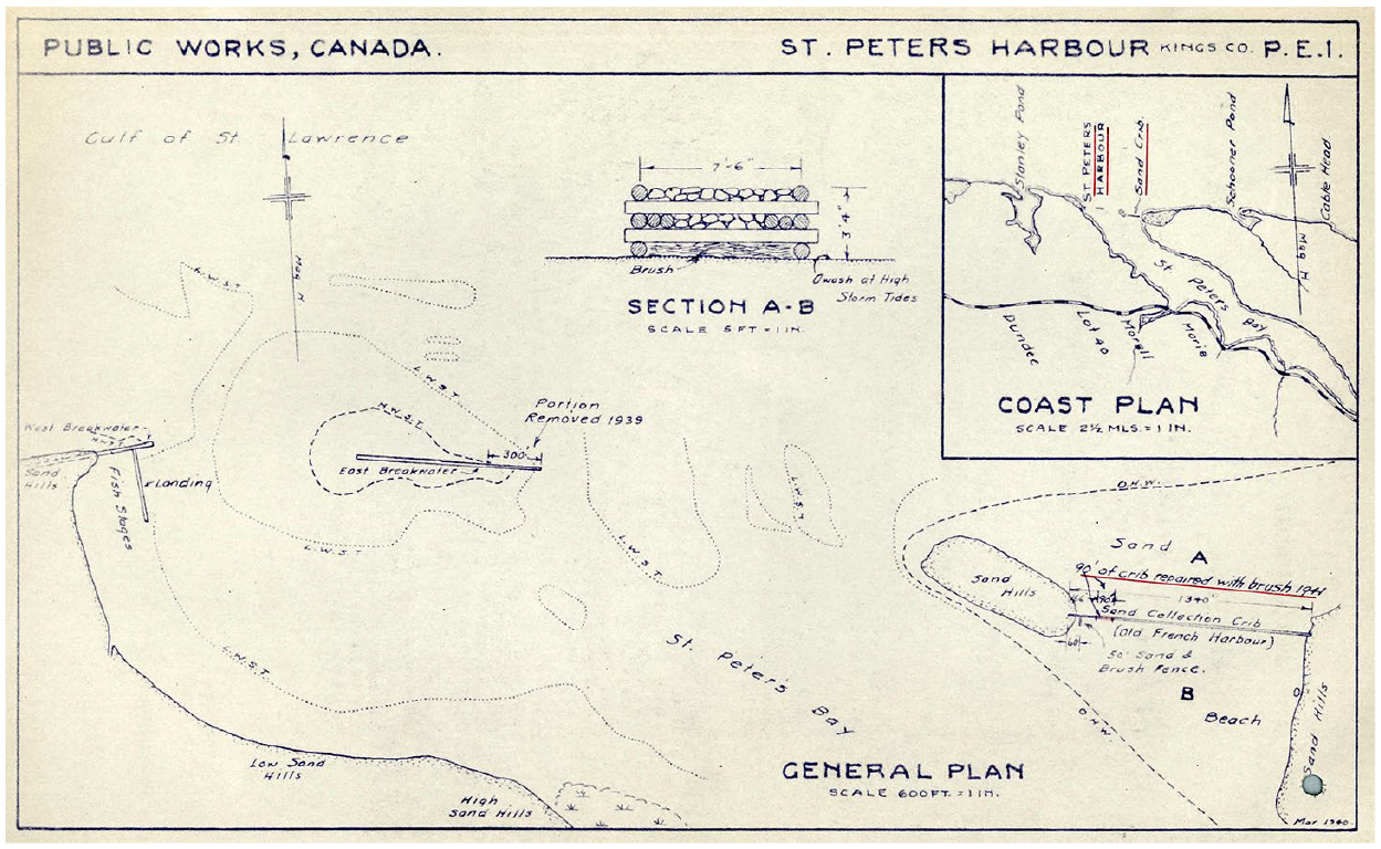
Department of Public Works Canada, District of Prince Edward Island. St. Peters Harbour, Kings County, Prince Edward Island, March 1940.
The first topographical map of the area, produced in 1946, shows the main channel into the harbour significantly to the east, with a new wharf at the former cannery site (Figures 10 and 11). By the 1968 aerial survey, all that can be seen of the former harbour infrastructure is the scar from the breakwater (map centre) and the remainder of the wharf, jutting into the inlet.
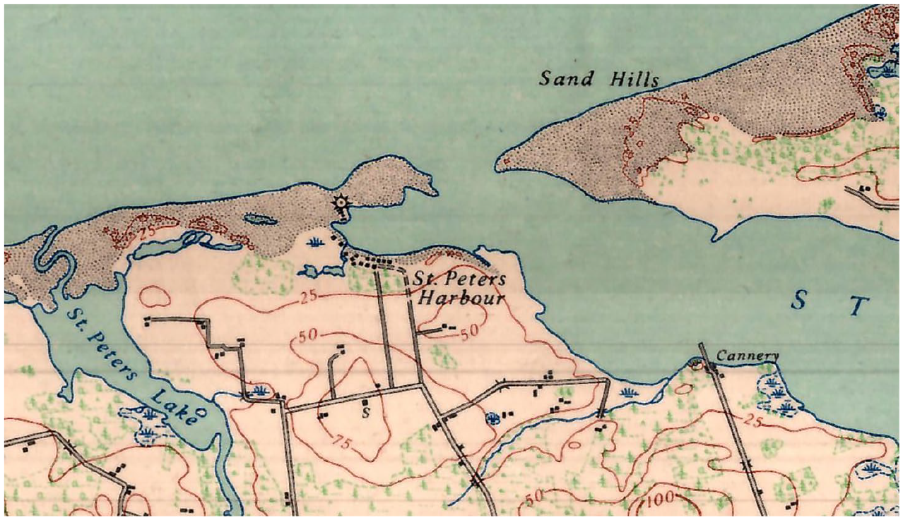
Surveyor General, Department of Mines and Resources. Mount Stewart, Prince Edward Island, Sheet 11 L/7. Ottawa: Department of National Defence, 1946.

St. Peters Harbour, PEI, 1968.
By the mid-twentieth century, with growth in motorized and air transportation, improvements in refrigeration, and the ease in shipping live lobster, the need for lobster canneries and worker accommodation at the shore dwindled. 38 But while the fishers were moving away from the shore, other people were flocking there. The era of the automobile and increased living standards brought North Americans to the island, and paved roads made the shore more accessible. 39 Seasonal homes or cottages along the shore boomed in the late twentieth century, 40 particularly with the completion of the Confederation Bridge in 1997 linking PEI to the mainland.
Twenty-first century
Along with the rise of coastal tourism, came a slightly lagging rise in environmental awareness. However, the protective role of the dunes has not been widely recognized here, and coastal management is still constrained by the British legacy of private ownership: today only 13% of the coast (slightly greater on the north shore with PEI National Park) is protected today by national, provincial and private groups. 41 Efforts to protect the dunes include localized marram grass planting and restricted access, but the effectiveness of these activities in maintaining the overall ecosystem resilience has not been demonstrated in the face of increasing storm activity.
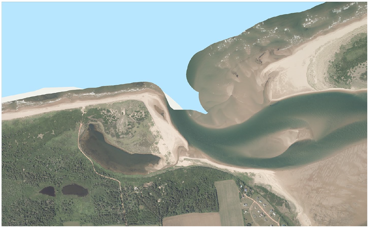
Although there is no longer a fishing harbour at the mouth of St. Peters Bay, and the channel is now marked by lit buoys that are set out for the fishing season, the shifting sands continue to be a challenge to navigation. Between 2000 and 2020, the aerial photos illustrate a westward progradation of the tip of Greenwich 42 and more changes in the channel. But the dunes between the bay shore and the lighthouse – now accessible by road – have also grown, with increasing vegetation on the slopes (Figures 12 and 13).

St. Peters Harbour, PEI, 2000.
St. Peters Harbour, PEI, 2020.
The sand seems to be shifting ever faster now. After the winter of 2023, a new channel opened on the west side of the breakwater remains; where locals could once walk out to almost the end of the old breakwater, today there is no beach access (Figures 14 and 15).
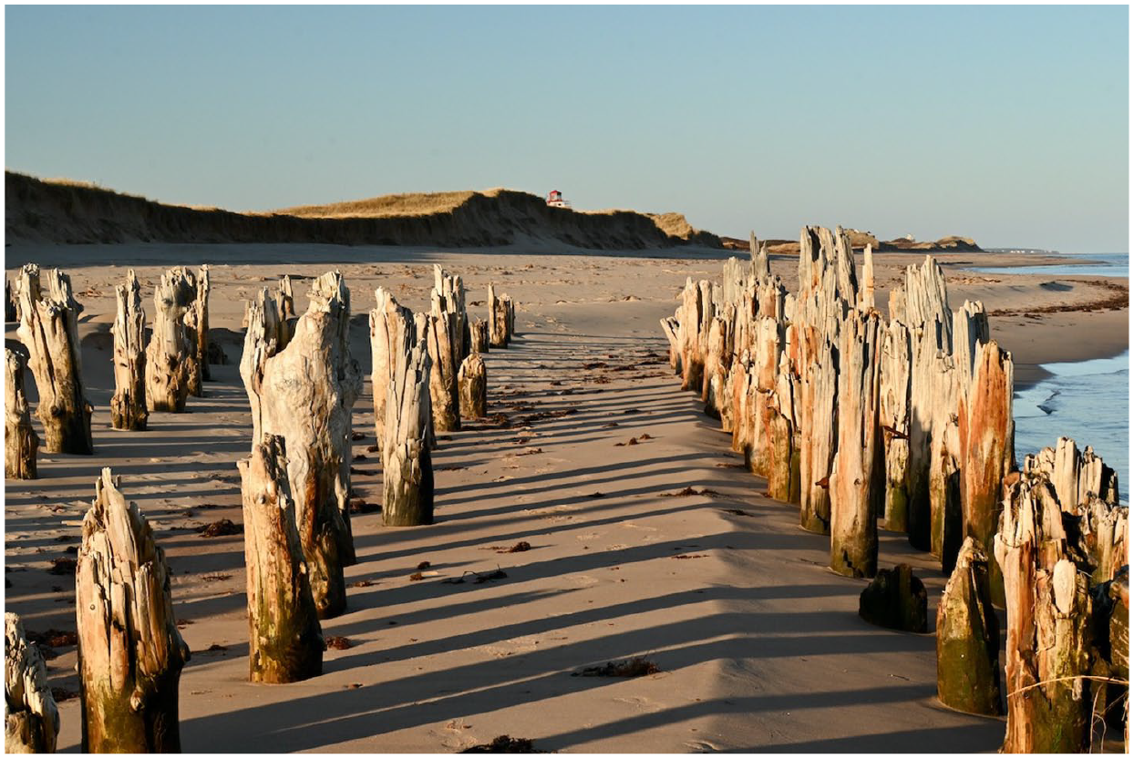
October 2022, after Hurricane Fiona, looking west from the breakwater.
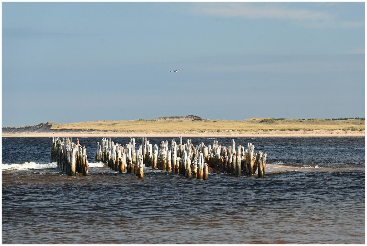
October 2023, looking east to the Greenwich peninsula.
Conclusions
These drawings, maps and photos demonstrate that there is nothing so constant as change, especially visible on a small island with sandy shores. Although we have only general reports and high-level sketch maps of the coast before the European settlement, the maps and surveys since the late eighteenth century illustrate rapid changes to the dunes on the north shore of PEI over the past 250 years, exacerbated by human activity. However, given the rapidity of shifting sand, maps and surveys must be supplemented with other records such as newspaper accounts and engineering drawings to see the complete picture.
As with other global locations, 43 grazing and deforestation contributed to the rapid destabilization of PEI’s coast, with an increase in sand budget, but people only began to see issues as they moved to the coast – whether for fishing or recreation – and established fixed infrastructure. In contrast to many European locations, though – perhaps due to relatively late deforestation, there were never any efforts at afforestation; sand drift was primarily an issue at harbour entrances, increasingly managed with engineered solutions.
With the majority of the PEI coastline in private hands, and multiple political jurisdictions, coast and dune management continues to be a fractured affair with numerous stakeholders and often-conflicting value systems. Research continues by various groups into isolated pockets of sand drift along the shore, but there is no holistic approach to managing sediment budget or the impacts of activities at other locations on the resilience of the coastal dunes.
Answering my research question of what we can learn from past experiences in managing the dunes first requires identifying how we can learn about coastal change. Georeferenced historical maps, charts, drawings and textual sources at this one site illustrate the impact – intended and unintended – of human activity of coastal dunes; extended to other sites, this approach will provide a bigger picture. Prince Edward Island, like any island, is both representative and unique; the same could be said for its coastal dunes. As this island becomes increasing vulnerable to climate change, not only from rising sea levels but from decreasing ice cover, we need to integrate our understanding of the multiple historical influences and perspectives, in order to protect our natural buffers.
Footnotes
Acknowledgements
The author is grateful for the support of Dr. Joshua MacFadyen, Canada Research Chair in Geospatial Humanities, and for the Canada Research Chairs Program for the funding that supports the GeoREACH lab (![]() ) and makes this research possible. Initial research and participation in the DUNES project workshop was also partially funded by the Social Sciences and Humanities Research Council (SSRHC), Canada. I would also like to thank Reg Porter for his extensive analysis of PEI map history, the staff at the PEI Archives and Records Office (PAROPEI) for their assistance in searching the archives, and the two anonymous reviewers whose insights greatly improved this article. And a huge thank you to Dr. Joana Gaspar de Freitas for her inspiration and warm welcome to this global research community.
) and makes this research possible. Initial research and participation in the DUNES project workshop was also partially funded by the Social Sciences and Humanities Research Council (SSRHC), Canada. I would also like to thank Reg Porter for his extensive analysis of PEI map history, the staff at the PEI Archives and Records Office (PAROPEI) for their assistance in searching the archives, and the two anonymous reviewers whose insights greatly improved this article. And a huge thank you to Dr. Joana Gaspar de Freitas for her inspiration and warm welcome to this global research community.
Declaration of conflicting interests
The author declared no potential conflicts of interest with respect to the research, authorship, and/or publication of this article.
Funding
The author received no financial support for the research, authorship, and/or publication of this article.
Ethical considerations
Ethical approval was not required for this article.
2
Romain Grancher, “Hybrid Islands: Some Reflections on the Intersection Between Island Studies and Environmental History,” Journal of Coastal Studies and Society 2, no. 2 (2023): 168.
3
Milica Prokić and Pavla Šimková, eds., Entire of Itself?: Towards an Environmental History of Islands (Winwick: White Horse Press, 2024): 351.
4
5
6
Joana Gaspar de Freitas, “Making a Case for an Environmental History of Dunes,” Anthropocenes – Human, Inhuman, Posthuman 1, no. 1 (2020): 1–5.
7
Joana Gaspar de Freitas, A Global Environmental History of Coastal Dunes (London: Routledge, 2025); Monique Palma et al., “It’s Not Only the Sea: A History of Human Intervention in the Beach-Dune Ecosystem of Costa da Caparica (Portugal),” Journal of Integrated Coastal Zone Management 21, no. 4 (2021): 230.
8
9
Geospatial Research in Atlantic Canadian History, directed by Dr. Joshua MacFadyen, Canada Research Chair in Geospatial Humanities.
10
Holland’s survey included detailed recording of Acadian infrastructure, summarized in Earle Lockerby and Douglas Sobey, Samuel Holland: His Work and Legacy on Prince Edward Island (Charlottetown, PE: Island Studies Press, 2015).
12
13
Jeff Ollerhead et al., “Annual to Decadal Morphodynamics of the Foredune System at Greenwich Dunes, Prince Edward Island, Canada,” Earth Surface Processes and Landforms 38 (2013): 286.
14
Norm Catto et al., “Geomorphic Response to Late Holocene Climate Variation and Anthropogenic Pressure, Northeastern Prince Edward Island, Canada.” Quaternary International 87 (2002):103, 106; Hope Parham et al., “The State of the Coast,” 11.
15
Norm Catto et al., “Geomorphic Response,” 106.
16
Ibidem, 104; Ian J. Walker et al. “Scale-Dependent Perspectives,” 224.
17
Jeff Ollerhead et al., “Annual to Decadal Morphodynamics,” 286.
18
Karthik Balaguru et al., “Increasing Hurricane Intensification Rate Near the US Atlantic Coast,” Geophysical Research Letters 49 no. 20 (2022): GL099793; Donald S. Lemmen et al. (eds.), Canada’s Marine Coasts in a Changing Climate (Ottawa, ON: Government of Canada, 2016).
19
Norm Catto et al., “Geomorphic Response,” 103; Donald S. Lemmen et al., “Canada’s Marine Coasts,” 108.
20
Elizabeth George et al. “Short Communication: Storm Impact and Recovery of a Beach-Dune System in Prince Edward Island,” Geomorphology 384 (2021): 2; Ian J. Walker et al., “Scale-Dependent Perspectives on the Geomorphology and Evolution of Beach-Dune Systems,” Earth-Science Reviews 171 (2017): 220–53. 224.
21
Coldwater Consulting, “Geomorphic Shoreline Classification,” 43; Jeff Ollerhead et al., “Annual to Decadal Morphodynamics,” 286.
22
Andrew Hill Clark, Three Centuries and the Island. A Historical Geography of Settlement and Agriculture in Prince Edward Island, Canada (University of Toronto Press, 1959): 33; Matthew G. Hatvany, “‘Wedded to the Marshes’: Salt Marshes and Socio-Economic Differentiation in Early Prince Edward Island,” Acadiensis 30 no. 2 (Spring 2001): 41–2.
23
The Acadian deportation, immortalized by Henry Wadsworth Longfellow in “Evangeline”, although the PEI deportation proceeded several years later.
24
Clark, Three Centuries, 41.
25
Rusty Bittermann and Margaret E. McCallum, “The One that Got Away: Fishery Reserves in Prince Edward Island,” Dalhousie Law Journal 28 no. 2 (2005): 386.
26
Edward MacDonald and Boyde Beck, “Lines in the Water: Time and Place in a Fishery,” in Time and a Place: An Environmental History of Prince Edward Island, eds. Edward MacDonald, Joshua MacFadyen and Irené Novaczek (Montreal, QC: McGill-Queen’s University Press, 2016), 224.
27
Bitterman and McCallum, “The One that Got Away,” 397–8; Hatvany, “Wedded to the Marshes,” 46.
28
Samuel Holland reported Port Joy, Cardigan and Richmond Bays as ‘the only places where Ships of burthen [sic] can safely enter’ (Lockerby and Sobey, Samuel Holland, 75).
29
Bitterman and McCallum, “The One that Got Away,” 405.
30
MacDonald and Beck, “Lines in the Water,” 226–33.
31
In particular, the ‘Yankee Gale’ of September 1851 and the ‘August Gale’ of 1873 are well-known in Island history, resulting in the loss of hundreds of ships and lives on the sandbars of the north coast.
32
The population of the island increased from 7,000 people in 1805 to over 110,000 in the late 1880s, after which it started to decline again (Clark, Three Centuries, chapters 5–7). Increased population and land clearance in rural communities also meant increased livestock.
33
Douglas Sobey, “The Forests of Prince Edward Island, 1720–1900,” in Time and a Place: An Environmental History of Prince Edward Island, eds. Edward MacDonald, Joshua MacFadyen and Irené Novaczek (Montreal, QC: McGill-Queen’s University Press, 2016), 99–106.
34
Douglas Sobey, “The Forests of Prince Edward Island,” 82.
35
Joana Gaspar de Freitas, Coastal Dunes, Chapter 4.
36
Norm Catto et al., “Geomorphic Response,” 106.
37
The 1928 Cummins’ Atlas (![]() ) used Meacham’s 1880 maps for shoreline configurations, and did not reflect the shoreline of the 1920s. The hydrographic charts are not publicly available, but were used by S.B. McCann in his December 1987 report “The Shoreline, Dunes and Marshes at Greenwich, St. Peters, Prince Edward Island,” in Morello Associates “St. Peters Bay Estates Project and Environmental Impact Assessment,” 1988.
) used Meacham’s 1880 maps for shoreline configurations, and did not reflect the shoreline of the 1920s. The hydrographic charts are not publicly available, but were used by S.B. McCann in his December 1987 report “The Shoreline, Dunes and Marshes at Greenwich, St. Peters, Prince Edward Island,” in Morello Associates “St. Peters Bay Estates Project and Environmental Impact Assessment,” 1988.
38
MacDonald and Beck, “Lines in the Water,” 236.
39
Alan MacEachern and Edward MacDonald, The Summer Trade: A History of Tourism on Prince Edward Island (McGill-Queen’s University Press, 2022), Chapter 4.
40
Joshua MacFadyen, Time Flies: A History of Prince Edward Island from the Air (Island Studies Press, 2023), 157.
41
Hope Parnham et al., “The State of the Coast,” 67.
42
Sojan Mathew, Robin G. D. Davidson-Arnott, and Jeff Ollerhead, “Evolution of a beach-dune system following a catastrophic storm overwash event; Greenwich Dunes, Prince Edward Island, 1936–2005,” Canadian Journal of Earth Sciences 47 (2010): 280.
43
Joana Gaspar de Freitas, Coastal Dunes.