
Abstract
Remote sensing technologies that offer unprecedented views of the planet are increasingly important in environmental governance. This paper contributes to understanding the role of these new data technologies in ocean governance, and the effects they have on the agency of governance actors. Specifically, it considers two cases where satellite tracking has been used to support fisheries governance in the UK Overseas Territories: one focused on marine turtles in the Caribbean, and the other on monitoring illegal fishing in the Atlantic Ocean. Through the analysis of interviews, event-based observations, and policy documents, the paper charts how stripped-back data collected and shared through new data technologies are packaged in governance logics to make them meaningful and actionable for governance actors. Emergent ontologies of the ocean enabled by remote sensing are co-produced alongside a social order that defines who needs to know what and who needs to act how as part of fisheries governance. The research has implications for those seeking to collect, share and use data for environmental management, and suggests a need to be more explicit and critical of the frames of meaning that are wrapped around environmental data to make them actionable.
Keywords
Introduction
Remote sensing technologies, including satellites, drones, and sensors, are increasingly important technologies in environmental governance (see for example, Ghosh, 2019; Nost and Goldstein, 2021; Lehman, 2016). This is particularly the case for ocean spaces that have previously been considered ‘under-governed’ (Drakopulos et al., 2022). Here, remote sensing technologies accompany an emergent imaginary of the ‘smart ocean’ in which real-time data streams are able to offer responsive feedback on marine management strategies (Bakker, 2022; Lehman, 2018; Ritts and Simpson, 2022). However, the new data technologies enrolled in ocean governance are far from neutral. The scientific knowledge supported by these technologies is strategically produced and mobilised by governance actors to define the parameters, scales and possible solutions to environmental problems (Havice et al., 2022). This paper examines the co-production of knowledge about ocean users through satellite-based remote sensing and the implementation of fisheries governance regimes in particular places: specifically, the co-management of a marine turtle fishery in the Caribbean, and the establishment of a large marine protected area in the Atlantic Ocean. It asks how new data technologies are used in the co-production of fisheries governance and the effect this has on the agency of different governance actors. The research finds that the data produced in each case is made legible for environmental action by encapsulating it within established governance logics that are supported by and supportive of specific frames of meaning and social orders. The study has consequences for thinking about the extent to which new data technologies – and the dynamic ocean worlds that they have the potential to make visible – have transformative potential to redistribute agency between and within state and non-state actors in defining future governance regimes for the ocean.
The paper builds on previous scholarship positioning environmental data and information technologies within the assemblages of their production, interpretation and use (Havice et al., 2022). It works with the concept of ‘new data technologies’, which have been defined as data assemblages that encapsulate “methods of data collection and generation, the data themselves, and the platforms, analytical techniques, and infrastructures developed to make sense of them for management purposes.” (Havice et al., 2022: 2174) Scholarship on environmental data production has challenged the widely held misconception that digitally-mediated data production offers “a neutral, more comprehensive picture of the planet.” (Nost and Goldstein, 2021: 4) Rather, environmental data infrastructures, including “the platforms, devices, and institutions” surrounding data production and use are shaped by uneven distribution of resources and power, and put to use for explicitly human purposes (Nost and Goldstein, 2021: 3). Indeed, for this reason, scholarship and policy on the advancement of environmental data infrastructures should attend to the “value-laden choices” around data production as a means of understanding its ultimate effects, how and why it represents the world in the way it does, what it makes visible and invisible, and who might benefit from it (Nost and Goldstein, 2021: 4).
In the context of ocean governance, there is a noted need for more research to explore the ways in which new data technologies produce or reproduce particular ontologies that shape the ocean worlds that are amenable to environmental governance (Boucquey et al., 2019). New data technologies not only produce representations of objects of scientific or political interest, such as fish or ocean currents, but in structuring how information is collected and distributed also configure the available governance roles and responsibilities that can be effectively performed (Toonen and Bush, 2020). In providing novel perspectives on the ocean and its users, new data technologies “transform how control over resources and space is determined.” (Havice et al., 2022: 2175) Building on this previous scholarship, this paper examines two cases of fisheries management that have integrated satellite tracking of ocean users into governance processes. The first case focuses on tracking marine turtles in the Caribbean as part of a co-management regime between local people and the government, and the second case focuses on the remote monitoring of fishing vessels in the Atlantic Ocean as part of establishing a marine protected area. Marine managers and scientists in both cases deploy satellite tracking as part of their ocean data assemblages, and enrol private philanthropic interest to support their cause. Focusing on these cases, the paper foregrounds the importance of the governance logics within which ocean ontologies afforded by new data technologies emerge and their effects on the distribution and usability of knowledge about ocean spaces and resources. The effect of these governance logics is to naturalise the governance roles and responsibilities of different actors, rendering some empowered to act and others not. As the discussion recognises, this has continuing implications for the role of both state and non-state actors in the management of the ocean. Although focused on the oceans, these findings also have broader insights for the political ecology of data (Nost and Goldstein, 2021) across other geographical domains, such as animal geographies (Philo and Wilbert, 2000) and ‘digital ecologies’ (Turnbull et al., 2022).
Governing the ocean with new data technologies
Ocean degradation is a recognised global challenge (Campbell et al., 2016). Overfishing, plastic pollution, ocean acidification and other climate change impacts are dramatically altering ocean environments and impacting on the people and other species that depend upon them (United Nations, 2021). To achieve a sustainable future for the oceans, it is deemed critical to ensure that environmental data is not only actionable, but also that it enables relevant actors to effectively participate in creating the “ocean[s] we need” (Visbeck, 2018). The management of both small and large-scale fisheries is one of the major concerns of global ocean governance (Campbell et al., 2016: 520). However, achieving effective fisheries regimes that deliver on local needs and international goals for conservation, sustainability and global trade (among other concerns) is far from straightforward. The vast areas of ocean space spanning both horizontally and vertically across the planet, and the highly dynamic processes and mobilities that they contain has made the ocean challenging for human-centric and land-centric ways of knowing and governing (Campbell et al., 2016; Lehman, 2018; Peters and Squire, 2019; Peters and Turner, 2025). Yet, recent advancements in remote sensing technologies that allow greater informational access into oceanic worlds offer a step change in this regard (Lehman, 2016; Lehman, 2020).
The recent proliferation of technologies capable of collecting data in and about the ocean, such as in-water sensors, satellite imaging, acoustic monitors, and remote vehicles, have been described as part of an emergent ‘smart oceans’ imaginary (Bakker, 2022; Ritts and Simpson, 2022). This reflects the fact that the oceans are becoming informationalised at a dramatic rate as “new productions of ocean space informed by growing global practices of information-gathering, geocoding, and synthesizing via networks of scientific and political actors” are taking effect (Boucquey et al., 2019: 484). Although remote sensing technologies, especially satellites, have been actively used in environmental science for decades (Lehman, 2018), recent years have seen a rapid uptick in the range of new data technologies being used in the ocean and the accessibility of the data produced through new data portals and platforms (Drakopulos et al., 2022; Bakker and Ritts, 2018; Drakopulos et al., 2023). This has profound effects on people's understanding and relationships with ocean spaces and resources.
Recent scholarship has called for particular attention to the worlds that are made visible by new data technologies. This scholarship notes that the way in which the ocean and its users are represented in data portals – or indeed in any scientific output – is important because the visibility of some things and not others makes some governance interventions “more possible (or easier to imagine) than other activities or mechanisms.” (Boucquey et al., 2019: 493) In an analysis of ocean data portals in the United States of America, for example, Boucquey et al. (2019) found that data portals offered a partial vision of the ocean, effectively representing biophysical features while discounting local and traditional knowledge about marine environments, and therefore making them less prominent for environmental decision-making. Likewise, an analysis of Global Fishing Watch found that the representations of fishing activity by satellite tracking vessels tended to obscure the political economy of fisheries by not revealing more details about the owners and operators of the vessels being observed (Drakopulos et al., 2023). The capacity for new data technologies to represent some things and not others places significant power in the hands of the designers of these technologies. As Toonen and Bush (2020: 133) note: “[o]ften out of sight, technical experts such as system engineers and programmers are the ones who turn fish and vessels into dots or algorithms, making fishing activities not only legible for others but also governable.”
Scholarship has also examined the capacity for new data technologies to enable wider access to ocean-related data and therefore to broaden the scope of actors that can contribute to ocean governance. Scholarship has suggested that there are examples of new data technologies that enable more democratised access to producing, sharing and using knowledge about the ocean (Campbell et al., 2020). The adoption of representational systems based on GPS-coordinates, rather than mapping on paper, is thought to shift the relationships between landscapes and their users (Rankin, 2016). Fishers’ knowledge of undersea topography, for example, can be stored and shared as geospatial references and thereby enable successful fishing without the mediation of the state (Campbell et al., 2020: 288–289). The website Global Fishing Watch is one example of an online platform that offers dramatically improved access to data. This website claims to make “anyone with an internet connection” capable of joining the fight for sustainability by scrutinising commercial fishing activity around the world (Global Fishing Watch, 2023). In this way, new data technologies are recognised to have the potential to contribute towards “democratising the oceans, bringing in wider-imagined communities of ocean citizens” (Toonen and Bush, 2020: 134). New data technologies are thereby seen to also enable more neoliberal approaches to environmental governance, including philanthropic investment and consumer-focused conservation (Gruby et al., 2021; Betsill et al., 2022; Hawkins and Silver, 2023). Animal tracking, in particular, has enabled the sharing of “dramatic, technologically mediated and circulated performances” around nature (Sullivan, 2012 202). The growing trend towards the use of new data technologies to draw private capital and economic interests into ocean governance is evidenced, for example, by an account of a white shark named Miss Costa that was tagged and sponsored by a sunglasses company in 2016, and subsequently promoted via social media (Hawkins and Silver, 2023). Analyses such as this raise questions about the relationships of responsibility that people can and should hold for the environment, which are made possible and rendered appropriate by new data technologies. For some analysts, therefore, geospatial reference data about the ocean can facilitate a decoupling between traditional state-based ways of knowing and seeing, which means that states “no longer have a monopoly on monitoring, reporting and/or verification within their sovereign spatial jurisdiction, nor in jurisdictions held in common with other states.” (Toonen and Bush, 2020: 127) Effectively managing fisheries in this context may require states to negotiate with private actors such as Global Fishing Watch or commercial fishing operators to gain access to information that enables the control of ocean resources within their jurisdiction (Toonen and Bush, 2020: 127).
However, as well as opening up access to information, new data technologies also continue to support traditional forms of state-based control over the ocean. By shaping the ocean worlds that are made visible and therefore amenable to governance, new data technologies can help maintain “hegemonic geopolitical and political–economic orders” (Drakopulos et al., 2023: 1099) including the agency of the state and its sovereign rights over ocean space. Satellite surveillance, for example, is recognised to support “a second wave of control over the oceans based on the remote collection and control of information” (Toonen and Bush, 2020), which expands state forms of seeing to “remote spaces previously outside the effective reach and governance of the state” (Chan, 2018 543) and associated resource extraction within the ‘blue economy’ (Silver et al., 2015; Blair, 2019). Either way, it is clear that the representations and access afforded by new data technologies have important implications for which governance actors feel empowered to act and in which ways with regards to the ocean.
In addition to making ocean worlds visible and enabling data accessibility, scholarship has also drawn attention to the importance of understanding the social orders within which new data technologies are mobilised. Environmental data is not neutral (Nost and Goldstein, 2021), and it also does not emerge in a neutral context. Existing governance logics, including geopolitical interests and resource distribution, shape its interpretation and use. In their study of Atlantic tuna management, for example, Havice et al. (2022: 2189) note how new data technologies have produced data about the lifecycles of tuna that had to “mix with existing and historical spatial power relations embodied in (often historical) political practices.” Their study found resistance to rethinking the management of interconnected tuna populations across the western and eastern Atlantic due to the persistence of political interests that has traditionally separated management regimes (Havice et al., 2022). Related scholarship on the conservation status of marine turtles has also identified tensions between different populations of turtles and the appropriate institutional scales necessary to manage them (Havice et al., 2018). These studies suggest that frameworks of ocean governance are co-produced alongside emergent ontologies of ocean space and resources: the production of one shapes, and is shaped by, the production of the other (Havice et al., 2022; recognising Jasanoff, 2004). These analyses can be extended by further exploring how data is mobilised and made actionable within particular governance logics: By tracing how marine managers and scientists produce and share data that translates “a stochastic pattern traced across a blank page” – or what Benson (2014 39) terms a ‘minimal animal’ – into highly effective resources for justifying environmental governance interventions. As Jasanoff (2017 2) has reflected “if a data set is to elicit a social response, knowledge of something that matters and principles for understanding why it matters must be generated together, or co-produced” alongside it. To examine this process, an analysis of fisheries governance can identify how the co-productive elements of identities, representations, discourses, and institutions (Jasanoff, 2004) provide appropriate wrapping to (re-)embed the data produced by new data technologies back into frames of meaning and associated social orders to enable governance action.
Methodology and case selection
The current study was conducted between November 2019 and July 2022. Empirical data collection included 20 semi-structured interviews with marine managers and scientists involved in designing and implementing the case study interventions. Interviews took place through online video calls and were supplemented with observations at related stakeholder meetings: including the Blue Belt Programme Symposium (Falmouth, UK. August 2019); the Blue Belt Programme technology workshop (London, UK. March 2020); and the Blue Belt Programme Showcase (Online, UK. June 2022). This study was approved by the University of Oxford Central University Research Ethics Committee (approval no. SOGE19-179) on June 26, 2019 and updated (approval no. SOGE20-32) on August 3, 2020. The researcher had no prior relationships or connections that opened access to the cases and interviewees.
The first case focuses on the satellite tracking of marine turtles in the Caribbean as part of a co-management regime in the Turks and Caicos Islands. Co-management is an approach to governance where power and responsibility for the management of a natural resource is shared between the government and local resource users (Carlsson and Berkes, 2005). Co-management is a paradigm of conservation that recognises the value of community-based natural resource management, but also recognises the limitations of local communities to manage resources that are shared across many communities, as is often the case with migratory species (Campbell et al., 2009). The satellite tracking of turtles in this case aimed to develop a long-term fishery management regime for turtles through stakeholder engagement, including management planning, research, outreach, and education (Richardson, 2014). The project led to a set of proposed management measures for updating legislation with regards to turtle fisheries. These included the introduction of size limits, which were approved and came into force in 2014 (Doherty et al., 2020).
The second case focuses on the remote monitoring of fishing vessels in the Atlantic Ocean to support the management of a marine protected area around Ascension Island. Marine protected areas are designated areas of the ocean with legal protection regulating access and use of marine space and resources. They have been a significant feature of ocean governance for many decades (Campbell et al., 2016) and are a major feature of multilateral environmental agreements, such as the Convention on Biological Diversity, whose most recent framework mandates governments to protect 30 per cent of ocean areas by the year 2030 (Campbell et al., 2024). The satellite detection of fishing vessels in this case provided the UK government with an overview of vessel activity, which supported the designation of an over 445,000 square kilometre marine protected area around Ascension Island in 2019. The use of satellites was deemed particularly important, because the vast ocean areas around Ascension Island were beyond the surveillance capacity of any patrol-ship-based approaches to monitoring and enforcement (Rowlands et al., 2019).
The two cases examined in this paper play out in the UK Overseas Territories (UKOTs): a collection of fourteen islands and archipelagos that fall under the sovereign control of the UK as former British Crown Colonies (Cawley, 2015). Although the majority of the UKOTs have their own constitutions that devolve powers to local representative administrations, these territories are still classed as non-self-governing territories according to the United Nations Special Committee on Decolonisation. The environment – broadly defined – is a devolved power to the territories, however the UK maintains jurisdiction in relation to international relations, defence, security and good governance (Montana, 2022). In practice, the UK government and UK-based non-government organisations and researchers continue to play a significant role in relation to biodiversity conservation in the UKOTs.
By focusing on the perspectives of professional marine managers and scientists in these cases, the findings reveal the intention of the authorities in collecting and disseminating satellite data. They explored what marine managers and scientists “wanted to happen, in relation to problems defined how, in pursuit of what objectives, through what strategies and techniques.” (Rose, 1999 20). The longer-term place-based consequences of these interventions, and the agencies of other individuals in shaping or resisting these governance regimes, including the challenges and concerns experienced by fishers and domestic users of coastal waters are important, but not explored here.
Two cases of fisheries governance
The two case studies involve marine managers and scientists using satellite monitoring technologies to track the mobilities of ocean users (marine turtles and fishing vessels) and produce data to support governance arrangements that control the use of ocean space and resources.
Turtle tracking around the Turks and Caicos Islands
The satellite tagging and tracking of turtles in the Turks and Caicos Islands (TCI) in the Caribbean was part of a UK-government funded project, which brought together scientists and the Marine Conservation Society (a non-governmental organisation), in order to gather data to support regulatory changes in local turtle fisheries (Stringell et al., 2013). Across their life histories, marine turtles have large migratory ranges frequently using lots of different habitat types across huge areas (Schofield et al., 2007). This has implications for their conservation, because turtles found in the coastal waters of one location may be important to the maintenance of a distant breeding population elsewhere (Richardson et al., 2009). Prior to this project, the turtles found in the waters around TCI were understood to derive from and return to nest on beaches across the Wider Caribbean region, however scientific evidence of this fact had not been formally established (Richardson et al., 2009). In order to fill gaps in understanding, the TCI turtle project used small satellite trackers that could be attached to green (Chelonia mydas) and hawksbill turtles (Eretmochelys imbricata) to identify the spatial ecologies of these turtles in the waters surrounding the TCI. Green and hawksbill turtles are species of conservation concern. However, for many locals, the turtles are part of a continuing culture of turtle harvest and use (Silver and Campbell, 2005).
The tracking of turtles in TCI, included 17 satellite tags on four hawksbill turtles, two adult green turtles, and eleven sub-adult green turtles (Richardson, 2014). The process of satellite tagging a turtle involved researchers pursuing turtles on motorised boats and then capturing them by hand by diving into the water, in what is sometimes referred to as a ‘turtle rodeo’ (Doherty et al., 2020). Some were also captured by free-divers or sourced directly from fishermen following their capture for consumption. The research team worked with the resident fishing community in TCI to undertake the collection of biological data and undertake satellite tagging (Richardson, 2014). As one of the researchers explained: “The majority of our in water biological research was invariably done in hand with fishermen. They were the ones that were taking us out to their sites where they would catch turtles, but rather than catch them, we would tag and release them. So they had a first hand in the science.” Once captured, satellite tags were attached to the highest point of the turtle's shell using a waterproof two-part epoxy resin covered in anti-fouling paint and the turtles were re-released close to the point of capture (Doherty et al., 2020). When the turtles were on the surface of the water, the tags communicated with satellites of a French organisation called Argos CLS (Collecte Localisation Satellites). The data was cleaned and processed, and then made available to the project team as a set of coordinates, but also in the form of maps positioning the turtle location alongside territorial borders.
The first turtle tagged in the TCI was given the name ‘Suzie’. As one of the research team noted: “Suzie took on a personality and helped the change: to effectively change the fishing legislation with the fishermen for a more sustainable future for the turtles in the TCI.” Suzie was a female green sea turtle that was purchased on the 24th of June 2009 from a fisherman on the island of South Caicos after she initially had been caught for consumption (Richardson et al., 2010). Suzie was tagged and released the following day close to her point of capture. For two months, Suzie remained in the inshore reefs and sea grass beds around East Caicos, before moving further afield across the Caribbean (Richardson et al., 2010). After visiting eight different states and territories in the Caribbean over a 145-day period, Suzie eventually returned to the inshore waters of TCI on 23 January 2010 (Richardson et al., 2010). Suzie helped the research team to construct a powerful narrative around the data collected within their initiative. The results of the satellite tracking were actively shared by the researchers with the local community. As one of the team explained: “we really disseminated that information to the community through posters, showing them maps of these migrations, and the tracks, along with text that was locally sensitive - written in a way that fishers would understand - and this would really help build support for the research and an understanding of what the project was doing.”
The naming of turtles also enabled each turtle to be placed within a personalized narrative that could allow the team to share ‘news’ of their progress as the turtles embarked upon their ‘journey’. Researchers have since reflected about how they would be stopped on a daily basis by kids asking: ‘Where Suzie at?’ (Richardson et al., 2010) and the team further engaged the resident fishing community through social surveys (Silver and Campbell, 2005) and an interactive video project using the Community Voice Method (Cumming et al., 2021).
The route that Suzie took was also highly significant for the shaping of her identity. Suzie travelled 6000 kilometres around the Caribbean over five months (Richardson et al., 2010), and as one of the team explained: “We were really lucky that that turtle did a big loop and came back to TCI because [the local fishing community] felt like it was their turtle, but it had also gone to all these other places around the Caribbean. They really felt that there was some ownership of that turtle, but at the same time, I think they realised that what they were doing in TCI with regards to the fishery, could also be impacting on these other countries around the overseas territories where these turtles would pop up to nest.”
As another of the project team concluded: “I think that really drove home the message to the fishing community, that nesting reproductive females and males needed to be protected so that they could go round and lay their eggs on all these different beaches around the Caribbean. So that was a kind of easier win when it came to the management of the fishery, that it was like okay every fisherman understands that you have to protect the reproductive adults.”
This helped the team to use the traces of Suzie's mobility to foster a sense of kinship between her and the local fisher communities, as well as broader publics in the UK. Suzie made visits to the waters of two other UK Overseas Territories as the first waypoints in her migration, including the British Virgin Islands (BVI) and Anguilla (Richardson et al., 2010). This was widely reported in the international press and further added to her notoriety. The UK Times Newspaper, for example, reported that “scientists watched with incredulity as she skipped non-British nations on her month-long trip”, dubbing Suzie an “anglophile green turtle” (Pope, 2009). Further coverage appeared in the The Daily Telegraph, Metro newspapers, BBC online, and “at least 25 other online news sites from around the world” (Richardson et al., 2010).
Notoriety about the project also helped researchers to garner additional financial support. The satellite tags cost thousands of dollars, and private philanthropic sponsorship of individual satellite tags also took place in the project (Doherty et al., 2020). Opportunities were created for private individuals (alongside members of the project team and local fishers) to participate in knowledge generation through allowing them to purchase satellite tags and to name individual turtles. The names of philanthropic donors were subsequently published alongside the data streams of turtle tracks that were made available online at www.turtleresearch.org.
Monitoring fishing around Ascension Island
The satellite tracking of fishing vessels around Ascension Island in the Atlantic Ocean was part of a UK-government funded initiative called the Blue Belt Programme, which sought to establish at least 4 million square kilometres of marine protected areas around a number of the UK Overseas Territories, including Ascension Island. This programme was coordinated by the UK Foreign, Commonwealth and Development Office with support from the UK Marine Management Organisation. Following a manifesto commitment by the UK Conservative Party in 2015, a large-scale marine protected area was designated around Ascension Island in 2019 extending out to the large Exclusive Economic Zone stretching 200 nautical miles beyond its shores.
The system developed to monitor the activity of fishing vessels around Ascension Island adopted satellite detection of Automatic Identification System (AIS) signals. These radio signals from ships are intended to broadcast their location to other nearby vessels, but can be detected from satellites. However, the AIS signals from ships are able to be turned off or the location of the vessel scrambled to offer a misleading reading. The vessels that lack an accurate AIS signal have often been called ‘dark vessels’ and are deemed to be possible threats to marine management, because they “are potentially trying to hide their individual identifiers” and may be engaging in Illegal Unreported and Unregulated (IUU) fishing (Cefas, 2018a 2). To overcome this constraint, the UK Government partnered with a not-for-profit company called OceanMind, which has developed systems for comparing the publicly available AIS data that indicates the location of vessels with the location of vessels derived from images of the ocean surface taken by Synthetic Aperture Radar or SAR (Cefas, 2018b). By using automated machine learning image recognition that compares the two sources of information, the marine managers hope to identify ‘dark vessels’ in Ascension Island waters. The gathered evidence provides the basis for investigations of suspicious vessels, which can either be intercepted at sea or become subject to later legal prosecutions.
In developing a management plan for the new Ascension Island Marine Protected Area, the movement of fishing vessels was assessed as part of threat analysis. Particular attention was given to these “dark vessels” that switch off their location transmission devices. As one of the marine managers explained: “Although they have AIS you can switch it off, it's just a button. So you can't see them. They can nip into [UK Overseas Terrritory] waters, fish and go out again.” According to the team, solutions needed to be found to grapple with fishing vessels that are not easy to detect. “They’re at sea for hugely long periods of time.” Explained one marine manager. “They operate right on the fringes of [the] territory […] at 200 nautical miles [from land] and you’ve got massive marine areas so even if you do have assets at your disposal, like patrol vessels or ariel surveillance, covering those big areas is really difficult.” As this marine manager continued: “The key issue really is identifying vessels that pose a risk, gathering the evidence to be able to demonstrate that they are in fact doing something illegal.”
The monitoring of fishing around Ascension Island was made sense of within institutions of territorial defence and sovereign control, which were reinforced through a process of “intelligence, risk assessment and threat analysis” as part of the Blue Belt Programme (Marine Management Organisation, 2018: 21). This centred on a historic analysis of probable fishing activity around the island from previous years as a means of understanding which parts of the Exclusive Economic Zone (EEZ) of Ascension Island were likely to be targeted by fishing and at what time of year. As a marine manager explained: “the evidence gathering for that initially was to do a historic analysis of fishing activity in the EEZs, and to get an understanding of the risk profiles of IUU fishing in the EEZs. So by using satellite surveillance, looking at where the fleets are operating. Putting that together with knowledge and evidence about the fisheries themselves, we can develop then a risk profile to understand when your highest risk periods are for illegal fishing.”
The subsequent report couched the data in terms of threats and risks. With the ‘detection’ of fishing activity part of the ‘evidence’ compiled to justify the establishment of the Ascension Island Marine Protected Area and the need for further targeted satellite surveillance going forward. Notably, these reports recontextualised the traces of the fishing vessel mobilities into static images that juxtaposed them with the boundaries of the state's Exclusive Economic Zone to reinforce the institution of sovereignty (Figure 1). They also wrapped up the data in the institutional practices concerned with the admissibility of evidence in legal settings. As one of the marine managers involved reflected: “There's information, intelligence and evidence and they’re all part of the process. The intelligence model that we operate is exactly the same as how the police, well, pretty much any regulator works.”
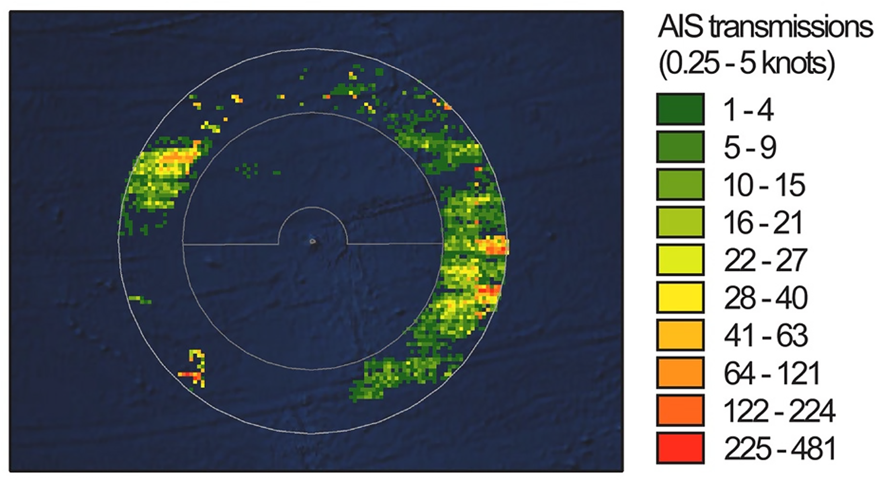
AIS transmissions from vessels tagged as ‘fishing’ operating between 0.25 and 5 knots around the waters of Ascension Island between January and March 2017. Inner circle represents the 200 nm boundaries of the Exclusive Economic Zone and the outer circle an additional 100 nm buffer in the high seas. Reproduced from Rowlands et al. (2019) under Creative Commons CC BY 4.0 Licence. Existing figure number removed from top left-hand corner.
In the case of tracking fishing vessels around Ascension Island, data from satellites was packaged within discourses of legality and illegality, and assessed according to its potential to offer admissible evidence in prosecution. Marine managers explained plans for the UK Government to maintain oversight of this work going forward as part of a “cost-effective” and “economy of scale” approach, particularly given the resource constraint of the governments of the UK Overseas Territories. AIS data detected by satellites and the cross-referenced satellite imagery were to be collated in UK data centres facilitated by OceanMind and the National Maritime Intelligence Centre.
However, largescale monitoring of the oceans is expensive. As with the case of tracking turtles, additional financial support was sought from private wealth to support the establishment of the Marine Protected Area. Fundraisers saw immense value in having tracking data for fishing vessels in order to make a case for investment in marine protection. As one marine manager explained: “you can show it on a satellite, you can look at Global Fishing Watch and see these great kind of dinner plates of areas in the Atlantic, areas nearly the size of France, that's a very attractive proposition for a philanthropist. This isn't reintroducing a few families of endangered birds or something. This is like: splat! Look, you can have something that can be seen from space!”
Here, the detection of IUU was redescribed by marine managers as not so much a threat to sovereignty, but rather as an opportunity to make a visible (from space) difference for marine protection.
Co-producing fisheries governance
The two cases presented here are distinct and similar. The collection and use of satellite data are instigated by different actors and intended to inform different approaches to ocean governance in different locations. However, they are similar in the ways in which marine managers and scientists use satellite data not only to show the movement of ocean users, but also to position those ocean users into a broader narrative of the social order. In both cases, the data produced is made legible for environmental action by passing it through established frames of meaning that are supported by and supportive of specific governance logics. Data streams about marine turtles and fishing vessels were wrapped in the co-productive elements of identities, representations, discourses and institutions that embedded them into particular social orders and made them meaningful and actionable to governance actors (see summary in Table 1). The question posed at the start of this paper asked how new data technologies are used in the co-production of fisheries governance and the effect this has on the agency of different governance actors. In this section, I will elaborate on how satellite data assemblages made ocean worlds visible and accessible in the two cases, the governance context in which these new data technologies were deployed, and how these concerns helped define the scope of appropriate action.
Two cases of satellite-derived tracking data supporting three logics of ocean governance.
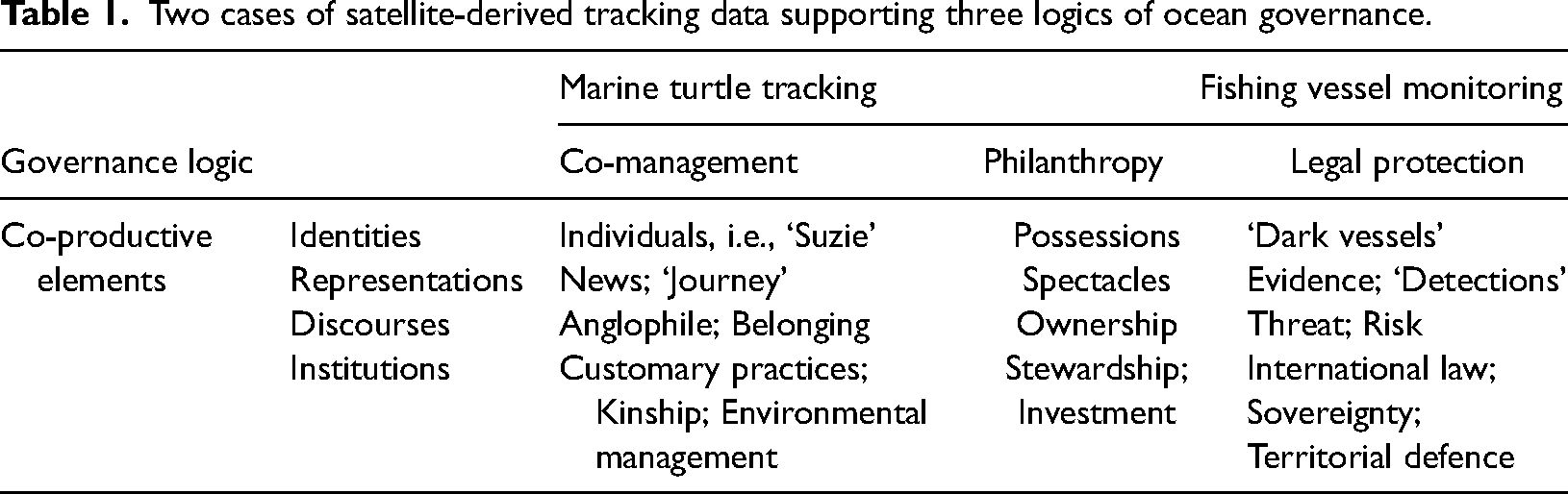
The propensity for new data technologies to make some aspects of ocean worlds visible and not others (i.e., Boucquey et al., 2019) is a clear concern in the cases evaluated here. Satellite tracking and the production of geospatial reference records strips back the associated context around the marine turtles and fishing vessels being tracked (as per Benson, 2014) and makes them more easily enrolled in the governance logics of co-management, philanthropy and legal protection identified in the two cases. The digital signifiers of ocean users are wrapped within co-productive elements that make the oceanic worlds that they inhabit amenable to governance. Visibility, in particular, centres on the identities that are assigned to the ocean users and the representations and discourses that are reproduced in disseminating information about them. The turtles of the Turks and Caicos Islands – such as Suzie – are made visible to observers as desirable friends of the islands across the Caribbean. As occurred with the white shark, Miss Costa (Hawkins and Silver, 2023), naming the individual turtles allowed each to develop a familiar identity for the researchers, fishers, and philanthropists involved in the programme. Meanwhile, the personal narrative built up around Suzie as an “anglophile” green turtle supported positive press coverage while also serving the technical needs of the researchers seeking to demonstrate the distribution of turtles across the Caribbean. Fishing vessels around Ascension Island, by contrast, were constructed as threats to the integrity of the Island's oceanic borders and malevolent foes to be kept away. The pixels of the heat map (Figure 1) show anonymous vessels, whose identities are not immediately evident, nor is the humanity of the crews on board. The intense interest in satellite surveillance around Ascension Island and other marine protected areas is often associated with significantly less effort to understand why the crews of vessels are fishing illegally in the first place (with some exceptions, e.g., Collins et al., 2021) and a limited prerogative to address the root causes of these activities (Toonen and Bush, 2020: 133). The simple stories of friend and foe that are presented in the two cases naturalise responses to these ocean users by appealing to traditional measures of sovereignty, specifically the “moral boundaries of identity” tied to the things that do and do not belong within sovereign borders (Kuus and Agnew, 2007 99). Hence, they support and legitimise the agency of the state to act in the maintenance of national security. Such forms of command and control intervention benefit from the dehumanising tendency of digital representations of fishing vessels on heat maps and ironically juxtapose against the claim that satellite surveillance of fishing vessels heralds the “end to the era of marine anonymity” (McCauley et al., 2016 1150). In part, therefore, the governance logics that the data are wrapped up in reinforce state-based control of ocean species as ‘wards of the state’ (Neumann, 2004) and ocean spaces as ‘territorial waters’ under sovereign control (Montana and Hartman Davies, 2024). However, this assertion is further nuanced by recognising how data accessibility also opens up opportunities for non-state governance actions.
The potential for new data technologies to broaden the scope of participation in environmental governance rests on their capacity to enable information transfer about ocean spaces and resources without the mediation of the state (Campbell et al., 2020; Drakopulos et al., 2022; Toonen and Bush, 2020). These effects were found in the cases analysed here. Indeed, in both cases, new data technologies afforded elements of ‘spectacle’ (Igoe, 2010) in the representation of the tracking data that created opportunities for philanthropic interest to increase financial support for ocean governance interventions. This was certainly the case for satellite tracking around Ascension Island, which as well as enabling state-based surveillance also offered the compelling representation of the Ascension Island Marine Protected Area as a ‘dinner plate […] that can be seen from space’, which could attract philanthropic investment to support the establishment of the marine protected area. The coverage of Suzie's movements in the international press further extended opportunities for the UK public in particular to make sense out of the satellite tracks of her mobility – presumably also enhancing the likelihood that they would donate to the UK-based charity that co-led the turtle tracking work. The shared access to data on marine turtles in TCI by governments, scientists and the local communities also meant that they were able to collectively witness the mobilities of the turtles within the local fishery and co-define the parameters for marine management. The local fishing community in particular were recognized as the most impacted actors by marine management interventions (Campbell et al., 2009), and ensuring that fishers ‘had a first hand in the science’ was seen as crucial to the legitimacy of the findings from the research and the buy in needed to promote the uptake of new fishing regulations. In contrast, the monitoring of fishing vessels around Ascension Island did not seek to involve the boat crews observed in data collection or sharing. Instead, the crews of ‘dark vessels’ were expected to respond to remotely produced “biopolitical climates” of fear and control (Shaw, 2017 891) created through awareness that their movements were being watched from above. The fact that fishers in this case were subject to surveillance without their participation, and that they were not engaged in a dialogue about the marine management challenge being addressed leads to a distancing between fishers and the authorities that seek to regulate them. This, as previously noted with respect to Global Fishing Watch, “runs counter to contemporary fisheries governance which [increasingly] emphasises interactive decision making” as a productive pathway to better social and environmental outcomes (Toonen and Bush, 2020: 133).
Similar influences between actors and agency played out as a result of the geopolitical and resource contexts in which new data technologies were operating in these cases. By virtue of their small size and colonial status, many of the UK Overseas Territories, including the TCI and Ascension Island, have limited funding, people and appropriate infrastructure needed for environmental governance (Montana, 2022; Campbell et al., 2009). The monitoring of fishing vessels around Ascension Island was described as too expensive and technically complex to be locally managed by the marine managers involved, meaning that the effective functioning of this new data technology required the centralised control of data by UK government bodies in ‘centres of calculation’ (Latour, 1990) located away from the UK Overseas Territories themselves. While there is a clear argument for economies of scale in supporting many of the UK Overseas Territories with marine surveillance, the centralised control of the new data technologies also has the effect of displacing agency away from those people most affected by the decisions that this data supports (noted in Adams, 2017) and can also reinforce colonial territorial claims whose legacies are increasingly being drawn into question (De Santo et al., 2011). The distancing effect of satellite tracking was less pronounced in the case of turtle fisheries management in TCI. In this case, considerable effort was made to bring the satellite data back into the frames of meaning and social orders of the communities being governed and even enabling affective bodily encounters between fishers and turtles as part of fostering a sense of responsibility for environmental action. More broadly, however, there is arguably a major concern about the differential access that different countries have to some of the new data technologies that are now being used for ocean surveillance and the social orders they uphold (Montana and Hartman Davies, 2024). For the UK Overseas Territories and other small states, the growing dependence on technologically-intensive data gathering assemblages in environmental governance has the potential to further entrench power differentials between states (Lehman, 2016; Toonen and Bush, 2020: 132) including their capacity to take advantage of or resist economic opportunities in the ocean (Silver et al., 2015; Blair, 2019).
Conclusion
The analysis in this paper reaffirms the value of recent lifecycle approaches to analysing environmental data, including the “extensive systems of sensors, scientists, and technicians that make these processes possible” (Lehman, 2016 114). The contrasting cases provide evidence against technological determinism in the production of knowledge for environmental governance. The use of satellites to produce knowledge about the ocean in both cases did not pre-determine the kinds of governance logic that were ultimately supported. Instead, the two cases showcase the adaptive potential of data streams and the assemblages that produce them to be highly mobile, sharable, used in different places at once, and received by different audiences in different ways. The cases illustrate how satellite tracking of ocean users for both marine management and science results in more than just the production of neutral knowledge about their mobilities. The data produced in each case are wrapped within identities, representations, discourses, and institutions that draw them back into frames of meaning and social orders that make them amenable to action.
The adaptability of environmental data to be supported by and supportive of different governance logics opens up opportunities for further scrutiny and also invites more creative approaches to ‘being otherwise’. There is a clear need for greater attention on the designers of these technologies, who have immense power in defining what is seen, in which way, and who has access to these representations (Drakopulos et al., 2022; Drakopulos et al., 2023; Toonen and Bush, 2020) And also to the governance logics within which environmental data is being curated, evaluated and used (Vurdubakis and Rajão, 2020; Nost and Goldstein, 2021; Jasanoff, 2017). This is particularly necessary if evidence-informed deliberations about the environment are to be shaped by a more grounded consideration of different value-positions about desirable social orders, rather than an uncritical trust in numbers that naturalise what is deemed to be appropriate action Taking account of the governance logics that are supported by new data technologies places an onus on data producers to exercise cautious attention in how they curate data collection, sharing and use. To have desired impact, those involved in data curation need to actively think about how environmental data is contextualised and interpreted where they want the data to take effect (Jasanoff, 2010). This means placing value in understanding the culturally-located ways in which people make meaning about themselves and the world around them, as well as on the technical precision and efficiency with which environmental data is gathered. It also means creating opportunities for other actors to define, contest and reject the frames of meaning that are being wrapped around environmental data in a given context. Achieving this in a just and equitable way is likely to bring more diverse actors into the design, development and use of new data technologies. As advances in remote sensing technologies and the growth in capabilities for big data processing using artificial intelligence offer an increasingly datatified view of the ocean, there is a pressing need to craft strategies for the collection and communication of environmental data that continue to support the agencies of multiple actors and support the social orders necessary for the oceans we need and want.
Footnotes
Acknowledgements
The author would like to thank the anonymous reviewers, the University of Oxford Technological Life Research Cluster, participants at the RGS-IBG Conference (2022), and participants at the Science and Democracy Network Annual Meeting (2022) for their comments and feedback on earlier versions of this article.
Funding
The author disclosed receipt of the following financial support for the research, authorship, and/or publication of this article: This work was supported by the Leverhulme Trust [ECF-2018-097].
Leverhulme Trust, (grant number ECF-2018-097).
Highlights
The production of environmental data through new data technologies can strip information from its context. Two cases where satellite tracking supports fisheries governance are examined. Data from satellites is packaged in representations, identities, discourses and institutions that determine how it is interpreted and used. Opportunities for participation of governments, fishers, funders, scientists and other publics are shaped by governance logics. More research is needed into the opportunities for diverse actors to define, contest and reject the frames of meaning around environmental data.