
Abstract
How might chemicals slip unnoticed across boundaries and through bodies in a range of material and bureaucratic registers? This article responds by extending emergent theorisations of ‘slipperiness’ into the nascent field of chemical geographies. Slipperiness offers a framing for chemicals that challenges and also situates contemporary managerial regimes that subscribe to universalised concepts such as pollution thresholds. Breaking slipperiness into four key characteristics - stealth, dynamism, persistence, and slippages - this paper draws on an empirical case study of Port Kembla, a heavy industry brownfield port in Australia, to outline how industrial chemicals have been instrumental in the port's ongoing relations with the broader residential community. This research takes place at a pivotal juncture in history when such sites are being actively repurposed to support decarbonisation infrastructures. The article hones in on four interrelated themes that emerged from the fieldwork as avenues for exploring the characteristics and consequences of chemical slipperiness. The first theme is the role of historical chemical contamination in maintaining port boundaries. The second explores how governance of contaminants is grounded in the concept of thresholds. The third examines the role of new energy transition infrastructure in disturbing and redistributing historical chemical accretions. The fourth theme is the knowability and visibility of chemical contaminants for residential communities in spatial proximity with the port. This paper develops the concept of bureaucratic slippage and focuses on the potential of voluminous understandings of space to overcome or challenge governance regimes that otherwise would fail to identify and manage contaminant risks.
Keywords
Introduction
This article addresses industrial port chemicals as ‘slippery’ substances (Boudia et al., 2018: 169). It considers the central yet often ‘unnoticed’ (Lou, 2022) role chemicals play within legacy industrial sites – i.e. historical industrial sites that are no longer operational – at a pivotal juncture in history when such sites are being actively repurposed to support decarbonisation infrastructures (Gibson, 2023). Chemical slippages in this sense are both conceptual and physical. They can be viewed in terms of chemicals’ physical ability to escape containment through leakage, spills, and conceptually through historically lax environmental management, while at the same time never entirely leaving their geographic locality. In discussing removal of hazardous waste stockpiles, Balayannis (2020) suggests chemicals can be representationally and bureaucratically erased from a location through such spectacles as paperwork and photographs of the clean-up process while still physically lingering in the soils, groundwater, and greater ecosystem of a geographic area. Through this process of lingering, chemical pasts also slip into chemical presents and futures as toxic legacies that may (not) be noticed and managed.
The issue of contaminated land and waters stemming from industrial operations has been a problem in Australia for centuries. Davies and Lawrence (2019) have meticulously identified documentation of the sludge made of water and suspended mine waste that coated huge areas of Victoria from the 1850s as a result of the gold rush, destroying arable land and waterways. They noted that for Australia the sludge problem was ‘the first stirrings of our awareness that industrial by-products constituted a form of pollution that should be controlled rather than just tolerated’ (2019: 07). Environmental legislation and its administering bodies only began to be developed in earnest to manage contamination in Australia from the 1970s (APH, 1998), at the same time as land contamination in the USA and Western Europe was identified ‘as a potential environment and economic problem’ (Catney et al., 2016: 75).
As this article explores, the port as a spatial category has faced concentrated issues with chemical toxicities and contaminated land, partly attributable to the way ports globally have been delineated through planning, legal, and physical boundaries since the 1100s (Ažman Momirski et al., 2021). Chau (2022) points out that port governance is increasingly framed by economic competition, with spatial boundarisation – here I use the term to mean boundary-making practices and boundary apparatus rather than the physical act of bounding – in turn allowing ports to slip out of the regulatory frameworks of taxation and surveillance that apply to the rest of a state.
In the paper to follow I first outline how the concept of slipperiness has been developed in the chemical studies and geographies literatures, pinpointing particular ways in which it might be extended to further clarify and operationalise slipperiness. In doing so I identify four characteristics of slippery substances and their spatiotemporal and bureaucratic relations: stealth, persistence, dynamism, and slippages. Introducing the case study site of Port Kembla, I explore how these slippery characteristics of legacy port chemicals play a significant role in the port's historical and ongoing reuse, particularly with the development of green energy infrastructures and their interrelationship with environmental management. I then focus in on the patchwork legibility of chemical movements and accretions for fenceline residential communities with vested interests in the environmental and health impacts of port operations. This paper analyses and interprets the case study with the specific objective of offering a lens through which to think with slipperiness.
Slipperiness and slippages: Sensing and knowing industrial chemicals
Slipperiness as a concept has appeared briefly in chemical studies literature (Boudia et al., 2018) while also being developed in relation to spatial conditions within geographies literature (Choi, 2022). In applying slipperiness to the Port Kembla case study, I draw these different literatures together to extend and clarify slipperiness, and indeed slippages, in relation to chemicals. I aim to situate thinking on chemical slipperiness within the geographic literature because chemical relations have geographic specificity. The case study I present takes place on unceded Country, where traditional custodians include the Wodi Wodi people of the Five Islands Dreaming, Dharawal-speaking people, and the Yuin nation. The particular historical conditions of the port and its operations alongside the material qualities and social histories of the land itself are central to understanding the chemical relations in place: ‘[t]hese specific connections do not travel effortlessly to other places with other relations’ (Liboiron, 2021: 30).
Developing a ‘slippery ontology’ as a way of describing the characteristics of the extensive tidal flats of South Korea, Choi (2022) has expanded on the different registers through which slipperiness occurs spatially. She notes that slipperiness is both material and conceptual. In drawing out the idea of slipperiness Choi leans into the ‘in-betweenness’ of tidal mudflats as a space that is neither land nor sea, alongside their dynamism and temporalities. She establishes three modes through which slipperiness emerges: boundaries, matter, and verticality. In looking at boundaries, Choi highlights the impossibility of drawing definite boundaries and hard edges on a temporally and materially dynamic space. Through a focus on matter, she explores the need to become immersed in and interact with the tidal flats to really understand them. Finally, Choi outlines how tidal flats are not vertically legible but instead present nonlinear temporalities that challenge normative scientific sedimentary expectations: “[t]ime does not pile up neatly in tidal flats” (p.351).
In thinking with chemicals, this paper extends Choi's ontology of slipperiness in two directions. It applies the theory, and in particular the concept of ‘in-betweenness’, not to a specific spatial typology (the mudflat) but instead in relation to chemicals moving within space. This expands the applicability of slipperiness beyond the specific geography of tidal flats to other spaces (and relations between spaces) while staying true to its aim of exploring how slipperiness challenges contemporary ways of knowing. Choi also applies slippery ontologies as a potential mechanism for protecting the tidal flats from environmental harms. In turning to chemicals, I explore how slipperiness operationalised in strategic ways can also allow and even facilitate potential harms.
Turning to chemical studies, slipperiness has been addressed by Boudia and colleagues (2018) as one of five properties of chemical residues that helped them ‘reimagine how chemical matter matters’ (p.171). They specify that the concept of ‘slippery’ in relation to residues has several applications. Principally, chemical slipperiness is about residues’ ability to ‘escap[e] modern production and regulatory systems’, and indeed key to this is their ‘slick mobility’ (p.169), or capacity to ‘hid[e] in plain sight’ (p.169). We can therefore think of slipperiness in relation to chemicals as their ability to both evade notice and our ability to know them, aligned with Choi's impossibility of drawing boundaries onto slippery bodies. Further, Boudia et al. note that ‘the politics of residues are slippery too’ (p.169), by which they mean that regulatory and political response to chemicals out of place is ineffective and delayed.
This regulatory response can indeed be delayed, but the slipperiness of chemical politics goes further. As pointed out by Hepler-Smith (2019) regulatory understanding of chemicals is premised upon categorisation ‘on a molecule-by-molecule basis’ (p.536). Within this ‘molecular bureaucracy’, chemical toxicities are managed and regulated according to artificial and negotiable boundaries between chemicals and chemical classes, and are prompted by the ‘logic of industrial capitalism’ (p.551), prioritising profits over care. Hepler-Smith gives the example of decision-making on chemical substitutes for toxic chemical usage in consumer products wherein substitutes are chosen that will ‘minimize disruptions to existing systems of production while remaining legally and politically defensible’ (p.551) rather than genuinely prioritising the minimisation of chemical toxicity exposure for consumers. Liboiron further highlights chemical politics through the ‘threshold theory of pollution’, wherein ‘[s]tate-based environmental regulations in most of the world since the 1930s are premised on the logic of assimilative capacity, in which a body – water, human, or otherwise – can handle a certain amount of contaminant before scientifically detectable harm occurs’ (p.05). This, Liboiron points out, is rooted in ongoing colonial land relations that assume a right to land including the right to pollute it. Such procedures are more than simply delayed regulatory responses to toxicity but strategic decisions that can be categorised as bureaucratic ‘slippages’. Conceptual slippage is where meaning slips across concepts, conflating ideas and losing specificity, often leading to misinterpretations and loss of clarity or meaning. Conversely, bureaucratic slippages allow, sometimes deliberately, not just meaning but things – in this case toxicities – to fall through the gaps that form between various intersecting forms of ‘managerial ontologies’ (Liboiron, 2021: 57) or ways of knowing the world dictated through specific systems of management.
Conversely, within an Indigenous worldview, Redvers and colleagues (2020) point out, life and health at the molecular level crosses both planet and person. Our relationships with our broader environment should therefore be viewed through the lenses of ‘reciprocity, responsibility, and relationality’ (Redvers et al., 2020: 10). This is about not only an abstract connection of chemicals across bodies and the planet, but their intimate capacity to physically traverse the permeable matter of body and planet as part of the same ‘flesh’, without distinguishing between water and land, body and water body (Neimanis, 2017: 48). Chemicals’ ‘slick mobility’ (Boudia et al., 2018: 169) or ability to slip quietly across bodies undermines attempts to manage and regulate them within technoscientific, colonial, or capitalist systems. This application of slipperiness to chemical movements expands what Choi has articulated as a state of in-betweenness. Where a spatial locality may demonstrate in-betweenness through being in a state of flux – tidal flats are not quite land and not quite sea – chemical movements allow a slipping between states – from land to sea, and indeed across tidal flats – without registering their different spatial properties as boundaries. This chemical mobility further forces a refocusing on the conceptual nature of boundarised space, and encourages an examination of how such boundaries are constructed and maintained to give the illusion of control. Here ‘in-betweenness’ becomes a state of all spatialities via their permeability and connectedness to neighbouring spatial states.
This leads me to an exploration of terminology that has been developed to articulate chemical movements within the geographic literature. Bosworth (2017: 25) in discussing polluted and toxic water movements through geological materials into the bodies of people presents ‘permeability’ as a condition of ‘earthly materials (including human bodies)’ and subsequent differences in permeability as a central problem in thinking and politics. Permeability therefore describes not the nature of chemical movements but the condition of the spaces that they move through. Permeability facilitates the slipping of chemicals and liquids and is closely aligned with porosity in its application. Porosity as Neimanis (2017) uses it refers to the specific permeability of borders, whether the skin of humans and animals or the walls of sludge pits. ‘Porosity’ in this sense is also about the qualities of the medium through which chemicals travel, rather than the behaviour or detectability of the chemicals themselves.
On the other hand, the terms that have been established to describe the movement of chemicals do not fully capture the entanglement of regulatory systems and chemicals’ ability to remain invisible both physically and bureaucratically. ‘Leakage’ covers the escape of chemicals from where they are supposed to be, but implies accidental movement rather than capturing the complex construction of bureaucracies that allow chemical mobilities to evade notice. Balayannis (2020: 773), for example, describes how ‘pesticides had been leaking through their broken containers, seeping through the sandy topsoil’. Leakage in this context is a physical state of accidentally breaking free of a boundarised territory, here the container, and seepage are the movement of the pesticides through another medium – the pore spaces of soils. Slipperiness operates in close proximity with these terms but remains distinct in its qualities of movement and its applicability to chemicals within space rather than describing the features of the spaces they travel within and across.
In drawing together the interpretations of slipperiness across the literature and their applicability to chemical contaminants, the case study outlines four characteristics of slippery substances and their contexts, as follows. The first characteristic is their ability to evade notice and knowability or to be stealthy. This relates closely to Boudia and colleagues (2018) term of ‘slick mobility’ but separates mobility from the capacity of chemicals to evade and slip under the radar. This evasion can happen without mobilities, as static accretions can be forgotten by people or permitting over time or remain undiscovered. The second characteristic of chemicals is their dynamism. This corresponds closely with both mobilities and Choi's (2022) ‘in-betweenness’, and refers to chemicals’ capacity to move across and through the very volume of space(s) with no regard for conceptual or constructed boundaries.
The third characteristic is chemical persistence. While there are links between this concept and Choi's idea of nonlinear time, persistence goes beyond questions of the legibility of time within soil layers. It points instead to a tenacity of chemicals in specific spaces across time. While this would appear to undermine the fundamentals of slipperiness, bound up in persistence is chemicals’ ability to evade capture and control. The reshuffling of seabed soil layers in Port Kembla is undertaken not by tides but by machinery. As the seabed is upended the chemical accretions in its layers of soil are freed and made mobile, able to both enter new environments and resettle in new layers until the next disturbance. In this sense persistence is the ability to remain ungraspable through cycles of inactivity and mobility.
The fourth characteristic is slippages, bureaucratic and otherwise. Chemicals, both conceptually and physically, routinely fall through the gaps between different regimes of management. Slippages further evoke a loss of friction between adjoining concepts that allows definitional movement. Cram (2023: 14), for example, highlights how the introduction of the idea of a ‘permissible dose’ of radiation into US radiation protection policy allowed public health policies that originally did not permit pollution to affect anthropogenic health to morph into risk reduction where there is a trade-off to be made between health and (in the case of nuclear technology in the Cold War) national security. This is a conceptual slippage that facilitates spatiotemporal chemical mobilities and persistence.
Within this context of slippery chemicals this paper hones in on four interrelated themes that emerged through the case study fieldwork as avenues for contextualising and exploring the characteristics of slipperiness. The first is the way in which chemical legacies of brownfield sites play an active role in both maintaining and undermining port boundaries within an expanding urban environment. The second is the threshold limits for contaminants established by environmental management agencies (such as the Environmental Protection Agency in New South Wales), and the ways in which these thresholds both acknowledge the ordinariness of chemicals in space while facilitating developments that disturb heavily polluted lands with limited legal and hazy physical consequences. The third is the accelerated movement of legacy industrial chemicals caused by the ramping up of construction of energy transition infrastructures in existing brownfield sites such as ports. The fourth is the knowability and visibility of chemical contaminants for communities in close proximity and overlapping use with heavy industrial sites.
Port Kembla: Context and methods
Port Kembla is a heavy industry complex combining multicommodity shipping movements with metals manufacturing and a range of transport and processing facilities (Warren and Gibson, 2024). It consists of an inner and an outer harbour. The inner harbour and its road infrastructure is completely off limits to the public without explicit permission from a company operating within it. Like the outer harbour it is occupied by companies largely centred on shipping of different commodities, and predominantly takes the form of storage facilities. Notably this includes two grain terminals, temporary imported car storage and a car terminal, as well as a coal terminal. Bluescope Steel also occupies a significant area of the inner harbour, with its steel manufacturing facility covering 760 hectares across both the inner harbour and the surrounding industrial zone (see Figure 1). Like the inner harbour, the entire steelworks is fenced and explicit permission is required to enter the site. South of the inner harbour and the steelworks is the adjoining outer harbour. This area is predominantly zoned as heavy industry, and includes an array of industrial operations including two cement manufacturers, a sulphuric acid plant, and a copper tube manufacturer. The outer harbour is more easily accessible to the public, with traversable road infrastructure and bike lanes and footpaths for use by the local community.
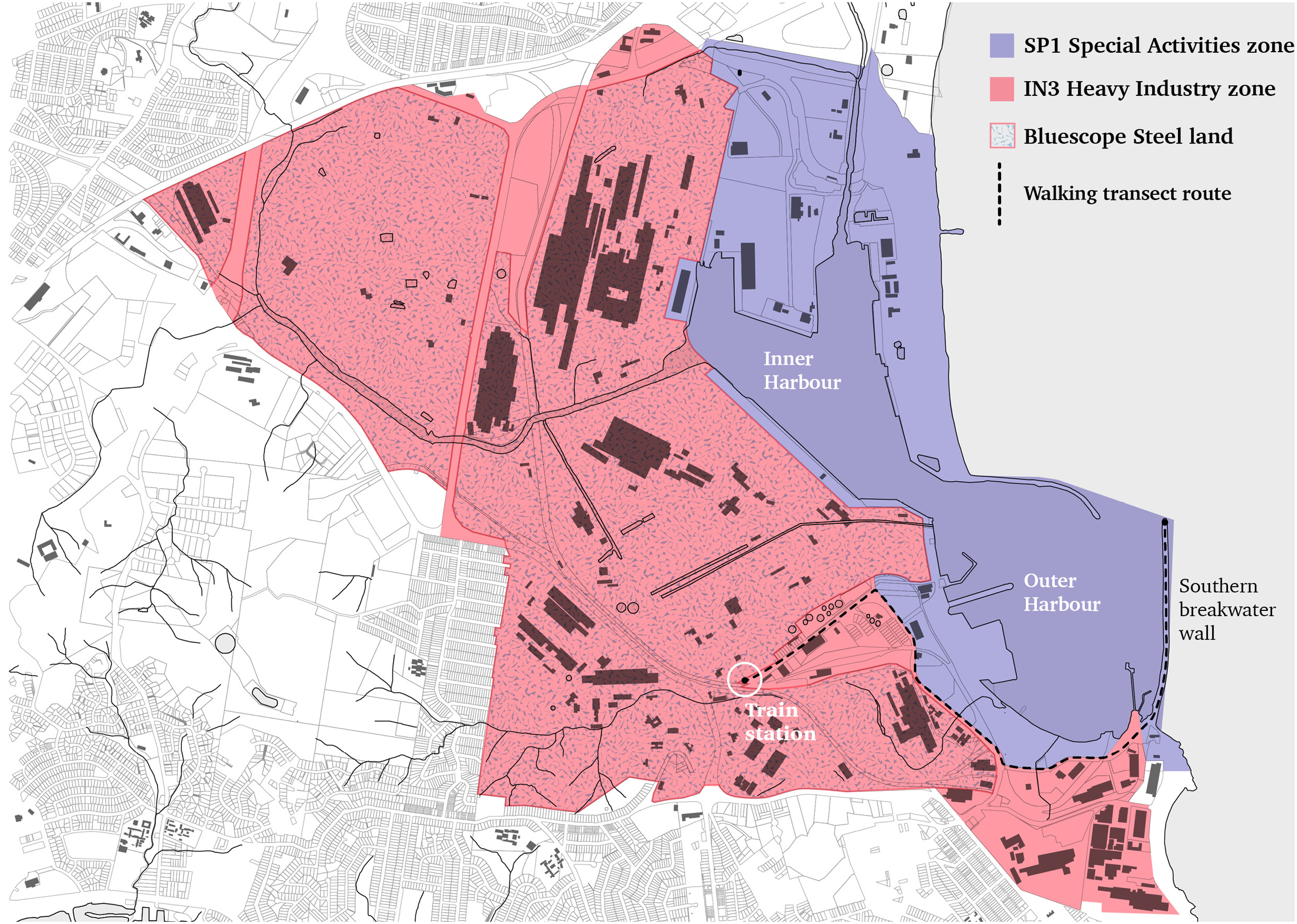
Diagram of Port Kembla with land use zoning and points of interest marked.
The port therefore has different levels and types of boundaries with varying porosity (cf. Cowen, 2014). Hein (2021: 03–04) notes while current literature largely views ports as wholly bounded, ‘their spatial footprint – through infrastructure, warehousing, and logistics networks – as well as their environmental impact – for example, air, water, soil, and noise pollution – extends far beyond the port's demarcated borders’. This variability in porosity can clearly be considered in relation to its capacity to exclude human bodies but only limited ability to prevent the movement of chemicals. Variable porosity is also a mechanism for facilitating conceptual slippages and is effective at boundarising knowledge of industrial operations.
I began walking the same route repeatedly throughout 2022, following the public pathway from the Port Kembla North train station to the southern breakwater wall. The intention was to focus on how I was able to physically traverse the port in relation to its complex boundaries, as well as observing its physical development as decarbonisation industries began the construction of their infrastructure. As I continued to walk this route, my research team was simultaneously becoming deeply engaged in the politics of decarbonisation and its potential to bring about the economic renewal of heavy industry as it played out in relation to Port Kembla at state and local scales (Gibson, 2023; Larkin et al., 2023). This brought a new angle to the walking observations as I not only noticed new industrial operations being constructed but was engaged in their political context. Further, I began participating in a regular environment group meeting from August 2022 to February 2023 that served as an interface between the local community, the port authority, and the many businesses operating within the port. The vigorous discussions that took place during these group meetings offered occasional glimpses beyond company rhetoric into the everyday work of environmental management while making visible regulatory systems in action.
I supplemented these observations with significant desktop research and conducted semi-structured interviews with a small number (6) of managers and environmental scientists from across the range of industries in the port. The project was approved by the Human Research Ethics Committee of the University of Wollongong (Reference: 2021/451), and all documents were in the public domain or already published academic findings. Participants tended to be in senior positions with a degree of autonomy and security in their employment. I further thickened my observations by concentrating on the industrial history of the port. Although I was on the lookout for evidence of chemicals in the present, it was only through consultation with environmental documents and scientific papers enquiring into historical chemical usage and their movements over time that I was able to understand their paths and points of accretion across the port. Although there were specific points along their route where residues made their movements visible, without these publicly accessible documents the legacy chemicals’ spatio-temporal shifts would largely be unknowable. At the same time, they offer only a partial view into what is in place within the port, making visible only that which they have specifically studied and ‘always producing blind spots’ (Balayannis, 2020: 03). There is a politics of limits to the knowability of chemical presence and activity that, I argue, poses uncertainties not only for researchers but also for the local residential community who live in proximity to the industrial port.
Chemical legacies maintaining port boundaries
In this first section I outline how the industrial history of Port Kembla and its chemical legacies play an important role in the maintenance of boundaries in the contemporary urban context of Wollongong. In doing so I focus on the characteristics of slipperiness – stealth, dynamism and persistence – that are fundamental to this ongoing spatial management. I begin by outlining the history of the copper refinery and subsequent environmental cleanup and management and its relationship with the port.
The difficulty in securing access that I encountered both physically through walking and via my attempts to recruit participants reflects the planning and legislative boundaries that define contemporary urban ports. Static buffer zones between heavy industry and residential areas are actively maintained (Harrison, 2005) and hard borders are increasingly used (Hauser et al., 2021). Port Kembla is governed by a planning policy administered at the state level and has specific zoning that maintains a distinction between the port and the surrounding residential areas, preventing encroachment into port space. The port also makes extensive use of hard borders, with the entire northern section of the port fenced off and access secured in addition to the fencing around individual industrial sites such as the steelworks. Hard port boundaries limit which bodies can gain access to these sites, keeping them largely out of public view and allowing the specifics of their environmental maintenance to slip out of sight, evading notice and knowability.
At the same time, this approach to boundarising ports means the amount of available land for heavy industry within them is finite, encouraging the continual reuse and redevelopment of legacy brownfield sites within port boundaries. Environmental legislation is only young but port zoning has in many cases been in place for several centuries. As such, legacy contamination is a major issue for new and operating heavy industry port sites. In New South Wales (NSW), the Port Kembla Harbour Act (Parliament of the State of New South Wales, 07) that ‘sanction[ed] the construction of a deep-water harbour’ was passed in 1898. In contrast, the Protection of the Environment Administration Act, under which the NSW Environmental Protection Agency was formed as the state's environmental regulator, was passed in 1991 (NSW EPA, 2022b), leaving almost a century of heavy industry operations without environment licences or monitoring.
Industry has long been central to port operations and geographic siting. As Ažman Momirski and colleagues (2021) note, in the twentieth Century ports expanded beyond straightforward transport centres as concentrated manufacturing and industrial areas were established close to or often within the port area, or indeed were factored directly into the planning of new ports (Palmer, 1999). Port Kembla itself was located at an existing coal export jetty, and the new port facilities immediately brought major industry into the port area with the Electrolytic Refining and Smelting Works, which specialised in refining copper, beginning in 1907 (Crago and Lowndes, 1931) and the port's current major industry, a steelworks, opening in the 1920s.
Despite closing in 2003 and subsequently demolishing most of the site structures, the copper refinery's final owners, Port Kembla Copper, have retained responsibility for the site remediation via an ongoing environment protection licence. To prepare for closure, Port Kembla Copper capped, or covered, the site with concrete or bitumen over a road base fill (Port Kembla Copper, 2008). Prior to that the company had embarked on several years of investigation and remediation of a ‘groundwater plume’. In 2004 the NSW EPA determined there were elevated levels of arsenic, cadmium, copper, lead, manganese, nickel, and zinc as well as sulphate and acidity in the groundwater beneath the site that was migrating toward Port Kembla Outer Harbour (Port Kembla Copper, 2009). By 2007 the company had established that the groundwater plume was largely stationary. The contamination of the groundwater had occurred through the unnoticed leaching of chemicals through the soil below specific operations within the refinery: ‘the source of the deep contamination was leakage of acidified copper sulfate solution from the electrolytic baths (and transfer lines) located in the Tankhouse building’ (Port Kembla Copper, 2009: 30) (see Figure 2). These were historical operations where over a long period of time the chemicals being used or produced by the refinery had leached into the soils and remained there without the operators being aware of its presence, demonstrating the first characteristic of slippery chemicals; their ability to slip under the radar and remain unknowable until a shift in land use such as the refinery's closure prompts their detection.
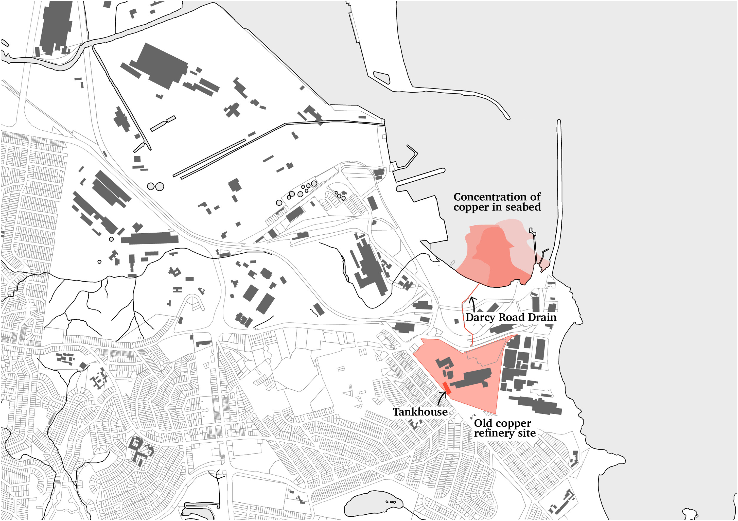
Diagram indicating the location of the old copper refinery, contaminant flows down Darcy Road Drain, and harbour seabed sediments containing high levels of copper at the outlet of Darcy Road Drain, the latter data loosely adapted from Jones et al. (2019).
In seeking to meet EPA remediation requirements, several actions were undertaken over three years, including modelling the groundwater plume. This modelling concluded the ‘natural attenuation processes within the deep aquifer would reduce contaminant concentrations within the plume to less than background levels by the time it reached Port Kembla Outer Harbour’ (Port Kembla Copper, 2009: 30). This is a precise description of assimilative capacity in action as Liboiron has defined it, which ‘strip[s] away the complexities of Land… in favour of elements relevant to settler and colonial goals for using the water as a sink, a site of storage for waste’ (2021: 40). Such a framework facilitates chemical movements across space, a slippery dynamism where contaminants diffuse into the surrounding environment or undergo biogeochemical transformations until they are below a certain threshold in any one sample. Such movement and diffusion were implicitly allowed by the state through their acceptance of the modelling.
Simultaneously, these chemicals demonstrate a slippery persistence, where they become ‘matter out of time’ (Boudia et al., 2018: 171) by lingering (Stanes and Gibson, 2017) beyond the industrial operations they were created from or for, and past structures and operations persist spatially through chemical accretions in underlying soils. Doeland (2019) outlines how waste, and here chemicals past their industrial usefulness are a form of waste, is ontologically ambiguous, both spatially and temporally being and not-being. Chemical wastes may be moved or find their way out of sight, but they never actually go ‘away’ to ‘a spatially and/or temporally ontologically alien realm that will take care of it’ (p.05). The licence continues to regulate discharges of surface water from the on-site wastewater treatment plant, despite the company aiming to surrender its licence and extricate themselves from ongoing maintenance of the site (NSW EPA, 2022a).
The copper refinery was not technically located within the port proper, although its chemical relations clearly extend into the port and its harbour. This is a clear example of the variable porosity of port boundaries (Hein, 2021). Further, the port proximity was one of the key reasons for the refinery's existence in Port Kembla and it was a key catalyst for the growth of the heavy industry land use fringing the port. As Momirski et al. (2021: 137) note, continuous land use across port and neighbouring territories ‘effectively dissolves borders as it creates continuous land use patterns’. As an industry that had been in situ and largely operational for nearly 100 years, the copper refinery had further made a significant chemical impact on the surrounding area – what could be considered another form of boundary dissolving via chemical dynamism, that is its movement through soils and waterways across zonings and boundaries. One interviewee I spoke to discussed the tangible differences in the port now that Port Kembla Copper had ceased operations:
… obviously in the 1900s everything got dumped in this harbour. I mean there's all sorts of heavy metals and it was obviously bad for the environment, but it was really good for the timber jetties because none of the – the marine growth didn't survive on the timber jetties…so when they stopped Port Kembla Copper and particularly in the last few years, the marine growth in the harbour has just gone ballistic…
Industrial chemical residues both persist by lingering in place and demonstrate dynamism as they slip through bodies and media to disperse and accrete in new locations. At the same time, there is a strategic usefulness to these chemical bodies and their capacity to demarcate spaces as legacy sites. The copper refinery is clearly a contaminated brownfield site, and in some ways this has proven advantageous for the maintenance of the port's borders despite the refinery site itself sitting just outside the port's zoning. While the NSW state government has stepped in to prevent the development of the site into nonindustrial uses, an interview participant noted that the contamination itself, and by implication the responsibility of managing it, serves to prevent most developers from pursuing a lease on the land:
We do get people come to us every now and then saying “hey, do you own this block of land? Can we lease it?” I said, “well no and yes, you can lease it, but would you want to? … best you go away and Google Port Kembla Copper and then come back and tell me whether you’re still interested.”
The implication here is that the legacy chemicals remaining in place within the site and the inability of Port Kembla Copper to relinquish the site to the government are enough to deter any potential developers. This deterrence demonstrates that while toxicities are primarily approached in relation to health risks, that risk and the associated regulatory costs of controlling and maintaining chemicals that persist in situ are more complex, with toxicities prompting particular actions that can help preserve port and heavy industrial boundaries. The toxic legacy of the copper smelter, the slipperiness of the chemicals that remain in place and threaten to disperse in unpredictable ways, and the site's relationship with environmental management regulations are useful for the port to maintain its buffer zone with the neighbouring residential areas. They also bring into focus the manufactured nature of spatial zoning and boundaries that structure the port and keep it conceptually separate from its urban surroundings.
Chemical thresholds as facilitators of accretion
In addition to chemical contaminants escaping containment efforts, as in the case of the groundwater plume, they are also allowed to be deliberately released in keeping with the threshold theory of pollution (Liboiron, 2021). In this section I explore how such chemical thresholds facilitate chemical accretion outside the bounds of regulatory control, and the ways in which certain characteristics of slipperiness, in particular bureaucratic slippages, play key roles in these slow processes of accumulation.
Indeed, while the copper refinery's fingerprints can be seen in the types of elevated chemicals across the water and lands of Port Kembla, its methods of dispersing them over the century were not always accidental. Alongside managing the groundwater plume, the company adapted a pre-existing wastewater treatment plant on site to treat stormwater runoff before discharging it into a local storm water main, Darcy Road Drain (Port Kembla Copper, 2009). While this is a controlled discharge, the NSW EPA nevertheless allows certain limits of chemicals (arsenic, cadmium, chromium, copper, lead, oil and grease, selenium, and zinc) to be discharged within the water as long as they do not ‘exceed the concentration limits specified for that pollutant’ (NSW EPA, 2020: 07). The refinery, alongside all other industries in the port, has been gifted the ‘ability to waste, even the right to waste’ (Liboiron, 2021: 57) through environmental governance.
Most environment licences have permissible limits of specific chemicals that can be discharged into the water or air. As Boudia and colleagues note, however, ‘our mistake, and sometimes our political folly, lies in believing that a little bit of something is the same as none at all’ (Boudia et al., 2018: 169). Across the operational timeframes and cumulative industries of the port, a little controlled and regulated chemical discharge on a regular basis can easily accumulate with unpredictable long-term effects on the landscape. Yet, it is not only the cumulative effects of multiple operations leading to the concentration of singular chemicals at issue. As Sprinkle and Payne-Sturges (2021) point out, low level chemical releases can mix and create unanticipated effects on individuals and the environment. Their study, focused on the USA, identifies that this ‘mixture toxicity’, facilitated through environmental and bodily accumulation, has been largely ignored across several decades and political-regulatory regimes. Mixture toxicities have evaded notice and indeed action largely because they ‘presented to regulators an infinitude of interactions … whose sorting, both scientifically and legally, was impossible’ (Sprinkle and Payne-Sturges, 2021: 19). Such conceptualisation of intermingling and unpredictable chemical combinations stands in contrast with molecular bureaucracy underpinning environmental governance (Hepler-Smith, 2019: 536), which ‘render[s] toxic environments tractable to regulatory politics on a molecule-by-molecule basis’ and ‘reduce[s] people and lands to chemical-by-chemical summations of harmful exposures’. The potential for unpredictable chemical mixtures as well as cumulative chemical accretions fall victim to slippage with both possibilities falling through the cracks of governance frameworks because they pose too much complexity to be readily governable.
Returning to the issue of cumulative chemical effects, scientists from the University of Wollongong, close to Port Kembla, conducted a geochemical analysis of sediment samples taken in 1996, 1998, and 2010 from across the Inner and Outer Harbour seabed (see Jones et al., 2019). Jones and colleagues (2019) identified heightened concentrations of lead, copper, gold, antimony, selenium, nickel, and zinc that had accumulated in the seabed but established that it was ‘difficult to determine’ whether it had entered the harbour as airborne fallout, slipping between volumetric elements, or through water runoff. Water-borne pollution from the copper refinery could be either secondary runoff, with rains washing deposited chemicals into stormwater drains, or surface runoff or groundwater movements from the site of the refinery itself.
With the slippery dynamism and persistence of the refinery's legacy industrial chemicals and the length of operations it is not overly surprising that when conducting tests to map pollutant levels on seabed sediments in Port Kembla harbour, Jones and colleagues (2019) found elevated levels of all the key chemical pollutants from the refinery from both controlled and uncontrolled releases. Significantly, the specific pollutants associated with the copper refinery were concentrated in the Outer Harbour around the end of Darcy Road Drain (see Figure 2), a waterway that runs between the refinery site and the Outer Harbour, into which several industrial operations discharge water from their sites.
Controlled chemical releases allow them to slip from accountability and regulation into the broader environment. Bureaucratic slippage grounded in assimilative capacity and threshold theories plays a significant role in this chemical movement and accretion, where governance happens on a manageable chemical-by-chemical and site-by-site basis. These are managerial structures for approaching the world that collectively ignore lived and complex chemical and land relations. In the case of Port Kembla, these management structures in combination with longer industrial histories and shifting understandings of toxicity have actively facilitated the unknowability of released and escaped chemicals. Which other chemicals have accreted in the waterways, aquifers, and sediments of the port remains at least partially unknown and, as the next section explores, even if they are discovered it does not mean they will be effectively managed. The capacity of chemicals to evade notice and persist in the broader environment beyond the confines of individual industrial operations and properties is partially attributable to bureaucratic slippage, wherein chemical relations in place fall by the wayside.
Energy transition infrastructures as environmental disturbance
In recent years Australian ports, in their role as heavy industry localities and central nodes for commodity flows, have become an epicentre of net zero strategies and decarbonisation initiatives (Hine et al., 2024). This section focuses on how slippery persistence and slippages play instrumental roles in obscuring the complexities of brownfield disturbance through the construction of energy transition infrastructures.
At present, much of the literature exploring port decarbonisation efforts and potential understandably deals with reducing emissions within the everyday business and operations of shipping and cargo handling (see Alzahrani et al., 2021; Philipp et al., 2021). A key area of interest for Port Kembla, however, is the approval and implementation of new green energy infrastructures such as gas pipelines and distribution plants being built with the ambition of directly supplying other heavy industry operations within urban port boundaries. This focus extends the concept of port decarbonisation beyond maritime transport into industrial infrastructures and forms a new layer of recycling of brownfield land and seabed within port boundaries.
At the time of conducting fieldwork there was a period of intensive dredging and emplacement work being carried out (see Figure 3) by a new company, Australian Industrial Energy (AIE). AIE is focused on the development of novel gas networks and was building a new double berth that can fit a permanent stationary ship designed as a gas storage facility, known as a floating storage and regasification unit (FSRU), with space next to it for gas carriers to moor and refill the FSRU when needed. While the gas will initially be liquid natural gas (LNG), a fossil fuel, it is firmly anticipated by AIE that this is a temporary usage and that eventually the terminal will be used to store environmentally clean fuels. For the project, AIE and the shipping company Höegh are partnering to design an FSRU that functions with green hydrogen alongside LNG (Squadron Energy, 2021).
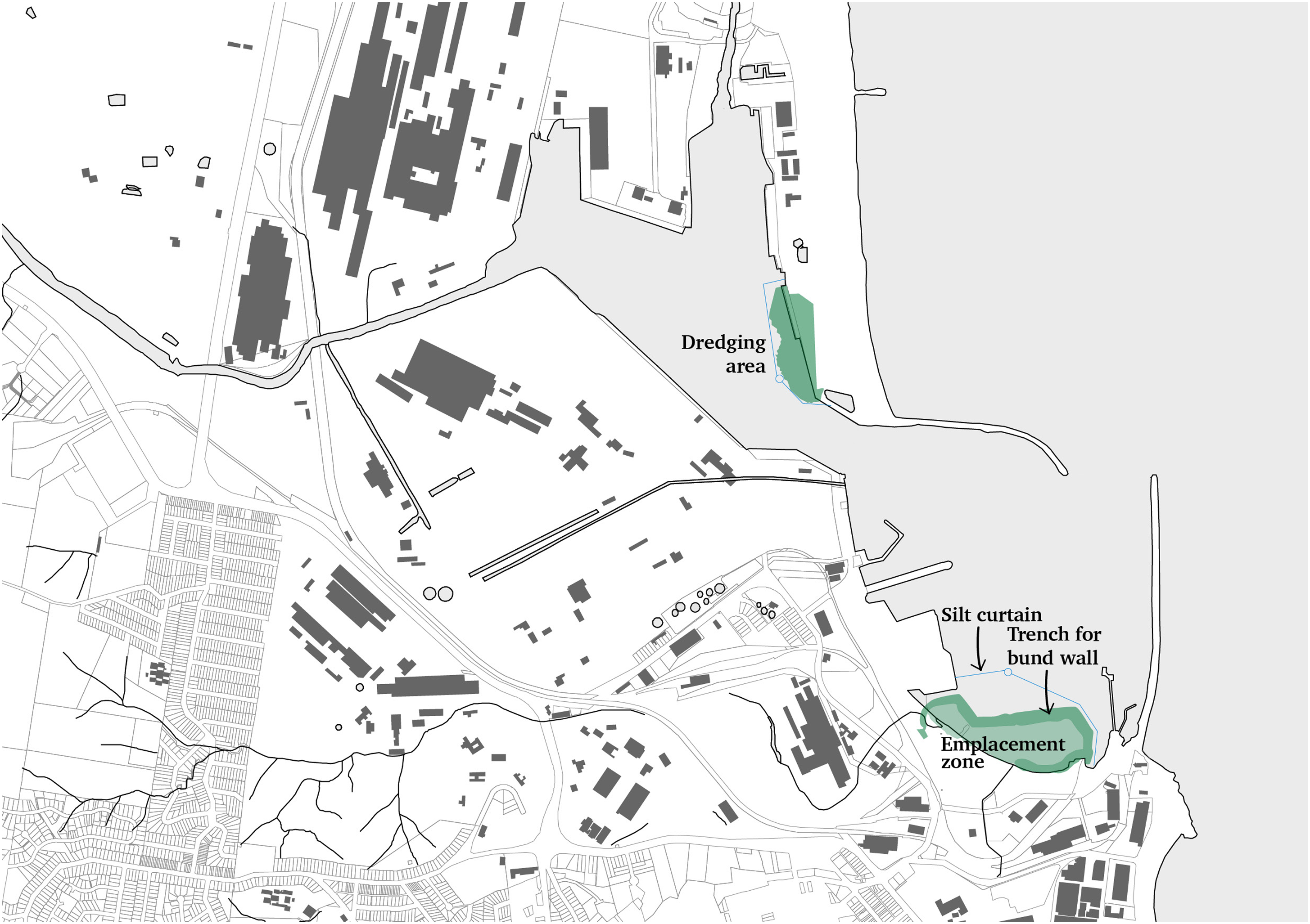
Diagram indicating the dredging and emplacement works across the Inner and Outer Harbour.
It is critical to recognise clean(er) energy not only as the energy itself, that is electricity or gas, but as produced, transported through, and wholly reliant on major, and often new, infrastructure (Coe and Gibson, 2023). While the deployment of these alternative energies will have positive impacts on global CO2 emissions, their infrastructures have very immediate environmental impacts and contribute a new layer of usage and disturbance to legacy brownfield sites within ports. Rather than a net positive, green energy infrastructures should be viewed as nuanced and complex confluences of sociomaterial actors and agendas – neither net positive nor wholly negative (Hine et al., 2024). I emphasise the material nature of energy infrastructures because they occur within a temporal trajectory of industrial developments within what have become highly chemically disturbed landscapes. The slippery, uncontrollable persistence of chemicals in the sediments and waters of the port from more than a century of heavy industrial operations cannot be separated from the future plans for the port and its ‘clean’ energy infrastructure.
A key element of the construction of AIE's berths was the removal of soil from both the leased land and its bordering seabed in the harbour to make the berth large and deep enough for two vessels and unobtrusive to the rest of the port's operations (see Figure 4). The flipside to dredging and excavation, however, was locating somewhere to ‘emplace’ or deposit the removed earth. The port has had a long-term vision of land reclamation in the Outer Harbour, with 2011 planning approval for a dry bulk/multipurpose terminal and container terminal through land reclamation extending significantly into the harbour (see Figure 4). As Savitzky (2022: 419) notes, land reclamation shifts territories and ‘land itself – becomes ‘fluid’, as it is broken down and recomposed, extended and shrunk’. Much like the fluidity of air and water, with land reclamation earth can also be viewed as a shifting, flowing entity and a loosening of boundaries as the edges between the port and the sea are conceptually - and literally - muddied. These spatial characteristics are analogous to the in-betweenness of land and water that Choi (2022: 342) identified in relation to tidal flats, where their ‘materialities constantly escape our efforts to know them’.
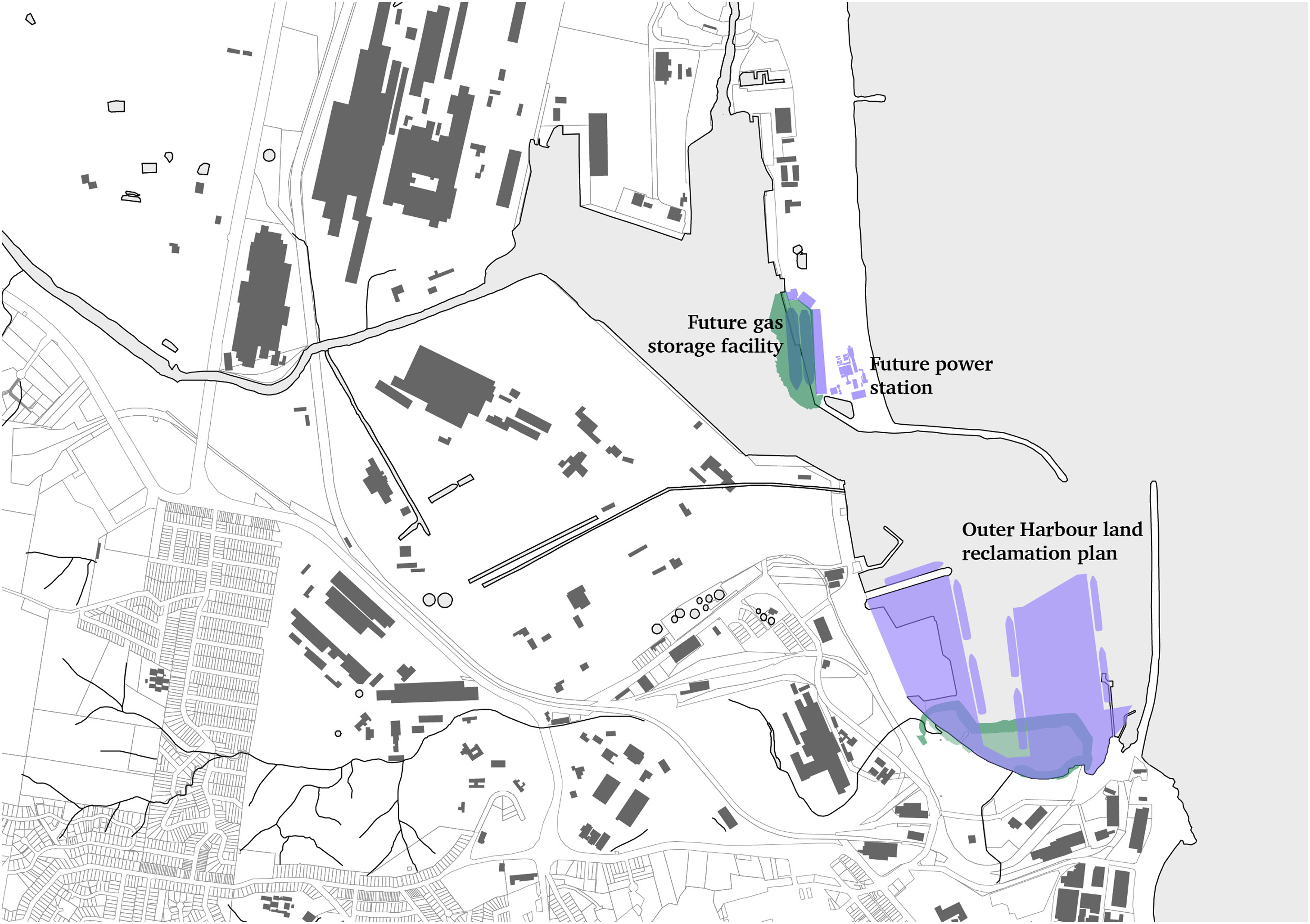
Diagram indicating the location of the future gas storage facility, power station, and the Outer Harbour land reclamation plan in relation to the dredging works.
AIE's dredge spoil was a convenient fill material that would contribute to building up the landmass in the harbour. AIE committed to capping the dredged material once it had been deposited, and it had several mechanisms to reduce the movement of sediments during the dredging and emplacement. These included a silt curtain (see Figure 3), which is a length of material attached to a floating foam boom. The material hangs vertically in the water like a curtain, encircling an area and preventing silt from passing beyond its barrier. The silt curtain extended several metres below the surface but did not reach the seabed. The company also set up bubble curtains so the dredge ships could enter the enclosed silt curtain areas. Bubble curtains release a continuous stream of small bubbles from a pipe along the seabed and acts as a barrier for particulates. Both impact reduction techniques are short term solutions for dredging operations. To contain the contaminated sediments long term, AIE was in the process – when I was conducting fieldwork – of dredging a trench in the outer harbour sediments (see Figure 3) to create a deep, ‘clean’ area of seabed where they would deposit clean (that is, uncontaminated) fill with the aim of building an underwater bund wall to encase the contaminated soils.
While a small element of the overall construction project, it was here that the history of chemical usage and movements in the port began to intersect with and problematise new green industries and their increasing disturbance of brownfield port infrastructures. Jones et al. (2019: 356) specifically note in their paper that ‘[u]ndisturbed harbour sediments can … play a significant role in storing potentially toxic trace elements unless disturbed by dredging when they could be remobilised into the environment’. The trench was being dug through the most contaminated area of the port seabed, as a result of the chemicals that were washed through Darcy Road Drain over many decades (see Figure 5). In GHD's (2018) Sediment Contamination Assessment Report compiled for AIE, they specifically note that of the seven harbour locations they targeted for seabed soil sampling, the highest metal concentrations were found in the sample positioned where the bund wall excavation was to occur on the edge of the outer harbour emplacement zone. This sample site appears to directly overlap the area of high metals concentration at the mouth of Darcy Road Drain identified by Jones et al. (2019): ‘[i]n some instances (lead, mercury and zinc), concentrations were an order of magnitude higher than in other samples’ (GHD, 2018: 30).
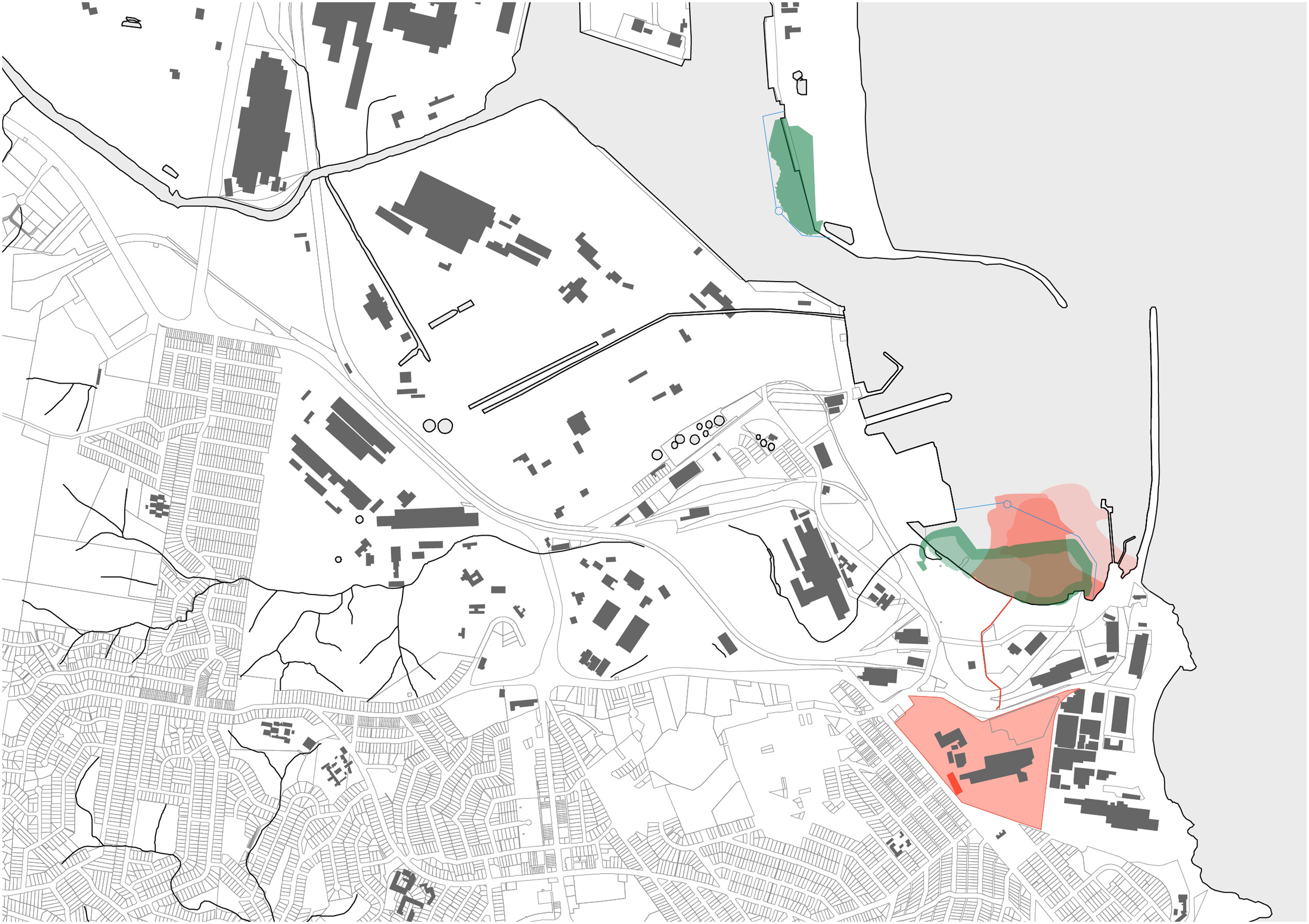
Diagram indicating the intersections between the seabed chemical contaminants from the copper refinery and the dredging and emplacement works.
Whether these sediments, disturbed through dredging and not entirely captured through the temporary control measures, resettle in new seabed environs or become part of a more active, dispersed set of relations in the open sea is unclear. Similarly unclear is why the dredging plan was allowed to proceed despite the clear areas of heightened chemical accretion in the seabed. It is possible this is once again bureaucratic slippage, wherein the land reclamation approvals were in place for many years before both GHD's (2018) environmental assessment and Jones et al.'s (2019) study and the later studies only had capacity to influence control measures during construction rather than project approvals. Through these layers of bureaucratic spatial ordering and chemical accretions green energy infrastructures become yet another period of disturbance, prompting new pathways for chemical mobilities within historically complex brownfield sites such as ports.
Knowability and visibility for fenceline communities
These ongoing port operations and their chemical effects that I have so far described have not been operating within a vacuum. The local community of the residential suburb of Port Kembla, which borders the industrial edges of the port, has long had complex and often very active relations with the port's chemical releases and accretions. This section outlines how the community has come to know and understand the spatiotemporal movement and accretion of chemicals and their potential impact on their health and lifestyles. It also expands on how boundaries and bureaucracies work to reduce the knowability of both port operations and chemical movements. In doing so, I highlight how slipperiness manifests through the characteristics of stealth and dynamism, and indeed how dynamism may be explored through competing interpretations of territory that frame chemical movements in contrasting ways.
Chemicals have been escaping from both the copper refinery infrastructure and from notice since it began operations and is now in the present maintenance period. Throughout its operations the smelter section of the copper refinery process emitted airborne sulphur dioxide (Bloem, 2007). In Eklund's history of Port Kembla, he notes that the copper refinery added a ‘bag house’ to capture larger particles in 1946 (2002: 29). It later replaced its smaller stack with a new 200-metre-tall stack in 1965 in response to localised complaints and new clean air legislation, in ‘the belief that the action of winds would disperse the pollutants and provide relief for local residents’ (Eklund, 2002: 185). In addition to sulphur dioxide, the more recent Illawarra Lead Taskforce found that the refinery had a significant impact on airborne lead levels in Port Kembla, and it is likely that cadmium and arsenic were also carried on the wind from the refinery (Noller, 2020).
The community has been living in relation to these chemicals and residents have been very active in advocating for community health over placing trust in established pollution thresholds. In 1997, for example, an extended campaign by the Port Kembla community led to the government agreeing to move Port Kembla Public School from its location next door to the copper refinery and rebuild it in a new location. The campaigners were concerned about the ongoing health risks posed by the proximity of the school to the refinery and its emissions.
There is a tension between community mistrust of regulatory systems and their need to rely on both the EPA and the government for information on chemical releases and accretions that might affect health. Despite reducing the capacity for public scrutiny of the port landscape through boundarising port infrastructures, and consequently increasing the public reliance on environment licencing and monitoring of port operations for current information on the chemical landscape of the port, the Port Kembla community remains engaged and cynical. Indeed, community members have taken matters into their own hands to run tests on matter that comes under scrutiny.
The sampling and modelling conducted by Jones et al. (2019) and its publication directly prompted local Port Kembla residents to take a water sample from Darcy Road Drain and have it tested in 2020 to understand the current levels of pollutants being discharged into the harbour and further accumulating in the sediment. When the tests showed heightened levels of chemicals that mapped to the copper refinery's pollutant history the residents approached the EPA with the results, prompting a ten-month testing program of the water in the drain. The results showed that the controlled discharges from the copper refinery alongside a sulphuric acid plant were traceable point sources of the contamination, but were not contributing enough to account for the total pollutant levels in the water. As part of the investigation, Port Kembla Copper identified ‘seepage waters’, that is uncontrolled waters that have escaped into the soil, from the location of the former blending shed area as a source of uncontrolled surface water contamination on site (NSW EPA, 2022a).
In addition to prompting an investigation and further control measures to reduce ongoing pollution into the harbour waters and sediments, the publication by Jones et al. gave community members concrete evidence of the location and type of contamination already within the harbour seabed. This prompted a new form of community engagement with the FSRU infrastructure and its environmental protection measures. While the silt and bubble curtains certainly meet the environmental requirements for containment, local residents observed the movements of sediments during the dredging process as dark plumes flowing out of the harbour and passing popular local beaches. There was concern from residents, borne of their long engagement with the toxicities of the port and emergent data on the specific chemical accretions in the harbour seabed, that these mobile sediments contained high concentrations of toxic chemicals being disturbed and deposited in new places on the seabed. Connectedly, residents were concerned that seaborne contaminants would be ingested by fish and mollusc populations that would then be caught and eaten by recreational fishers, often from outer Sydney and less knowledgeable in local issues than the Port Kembla community.
In seeking some action on behalf of the local populace, a resident contacted a news outlet to report on the issue. The decision to go to a news outlet was prompted by the understanding that the EPA was unlikely to take any action because the dredging and its containment measures had environmental approval. Within that approval a certain degree of ‘turbidity’ was allowable. The threshold limits of the environmental approval were higher than the local community was willing to tolerate, and indeed the type of environmental threshold appeared inconsistent with community concerns. This approach to chemical interpretation and the limits to chemical spatial management imposed by technoscientific models and regulatory parameters sat at odds with the community understanding of complex real-world chemical relations.
In considering this in relation to chemical dynamism, an expansion of territorial thinking from topographic to a voluminous view of space is necessary to fully engage with chemical movements through and particularly between air and water sheds. Bounding techniques such as fencing and zoning are able to exert very little control over vertical space, whether within the earth and groundwater or in the air. An engagement with both as highly interconnected material conditions in states of flow becomes necessary to think with both chemical movements and potential chemical mixing. Chemicals might slip quietly across borders, but to do so they must be embedded within physical flows such as wind or tidal movements that apparently hard borders such as fencing have no ability to contain. The community conceptualisation of chemicals as slipping fluidly through mediums - earth and water - and into and across bodies takes on a voluminous understanding of terrain. Voluminous here is about understanding space as elemental volumes where ‘height, depth and pressure intersect with social–natural relationships’ (Bennett and Dodds, 2023: 04). Squire (2016: 336) notes, for example, that the ‘voluminous terrain of the sea is dynamic and inherently relational’ where understanding, adaptation and negotiation are required to come to terms with its material qualities. Such a worldview makes it easy to accept that chemicals do not vanish through an assumed ‘self-purification’ (Liboiron, 2021: 04) of waterways and other volumes but instead have the potential to move elsewhere or accrete in place.
This approach to space sits in contrast with environmental regulators that are concerned with very immediate points of leakage and harm, and the edges of jurisdictions. The NSW EPA, for example, in explaining how it manages water pollution states that ‘[t]he EPA does not use licensing to regulate every potential pollutant that could be contained in a discharge or activity. This is because some pollutants are present at such low levels in a discharge that they are highly unlikely to pose a reasonable risk of harm to human health or the environment’ (NSW EPA, 2021). This indicates an emphasis on the quantities of select, individual chemicals at any singular point of release rather than the need to understand the relationalities and dynamism of the volumes into which chemicals are being released and their consequent behaviours.
It is significant that the community member that contacted the media outlet was connected with the Darcy Road Drain community sampling, and was well aware of the high concentration of contaminants in the dredged soil. In highlighting the colour or turbidity of the water they were not concerned specifically with the level of particulate matter in the water and its visual impacts on the water column: instead, they were concerned with the chemical levels contained within the particulates and the flow-on effects of disturbing the soils for the broader ecosystem. The environment licence for the dredging works included only weekly sampling for known industrial contaminants in the water near the Outer Harbour dredging (EPA NSW, 2022). On the other hand, the company, in consultation with the EPA, instigated ongoing real time water quality sampling for particulate levels across the construction works. This monitoring regime reflects vastly different priorities to those of local residents, but simultaneously meets the requirements mandated by the EPA. Similarly, the bureaucratic nature of environmental management and monitoring appears to have very little in common with the actual levels and spatiotemporal movements of chemicals.
Not only were chemicals slipping physically across the port and resurfacing within its future geographies of energy transition, but conceptual slippages around expectations for monitoring of toxicities and indeed definitions of the pollutants themselves came to define the relations between the local community, the EPA, and the company. Slippages emerge at the edges of social power, where only certain kinds of people – industry and environmental professionals – are allowed to identify and define when and how chemicals become toxicities. Similarly, the passing of chemicals from within industrial boundaries to the broader environment constitutes a point of (sometimes intentional) slippage. Through water discharge, for example, they are conceptually transformed from measurable industrial pollutant into a more abstract ambient water quality, becoming something no longer directly governable. Chemical movements and accretions are therefore not simply a matter of knowability for fenceline communities, although even forming a working understanding of these things requires engaged and concerted efforts and piecemeal, dogged knowledge-making. Communities must contend additionally with specific managerial ontologies that create particular ways of understanding the world that do not map easily onto community experiences or understanding of their local environment.
Conclusion
This paper has focused on Port Kembla as an avenue for understanding how legacy chemicals both evade notice and our ability to know them, examined through a concentration on how the spatiotemporal and conceptual characteristics of chemicals contribute to their ‘slipperiness’. Four geographically situated themes – boundary maintenance, thresholds as facilitating accretion, decarbonisation infrastructure as a new layer of disturbance, and the knowability of chemicals for fenceline communities – emerged from the case study fieldwork and became avenues through which these chemical characteristics could be identified and analysed.
I have sought to extend the usage and applicability of the concept of slipperiness beyond a description of spatial characteristics of in-between places such as mudflats. Through a focus on chemicals moving through volumes without regard for bounding practices and property delineations, this paper demonstrated that slipperiness can also highlight relations and permeability between multiple spaces with different physical properties.
Additionally, through the case study I have demonstrated that it is not only space that holds the qualities of slipperiness, but also substances moving through space. Through the development of the four characteristics of slipperiness and demonstrating their applicability to chemical behaviours, I have sought to highlight how chemical slipperiness can help us make better sense of historical and ongoing land use decisions. Indeed, this paper has further sought to demonstrate that slipperiness, when strategically operationalised, can facilitate harms as well as holding the potential for protection, particularly through the development of the concept of bureaucratic slippages.
Bureaucratic slippages offer a useful framing for articulating how certain concepts shift or fall through the gaps of governance and managerial regimes across a range of contexts beyond that of port infrastructures. Indeed, chemicals are not the only substances that ‘slip’, and ports are not the only geographic spaces where multiple managerial ontologies imperfectly intersect. There are no doubt countless parallels globally in similar contexts, where industrial infrastructure, legacy sites, and contamination linger in the present and managerial ontologies (Liboiron, 2021) collide in complex ways. I suggest that bureaucratic slippages might benefit from further conceptual development and empirical application in its own right to more fully develop the concept as a useful framing for analysing the effects of intersecting governance pathways.
Finally, the efforts of the Port Kembla residential community have highlighted how the active pursuit of chemical traces requires an engagement with their slipperiness to understand their mobilities, accretions, and ability to evade notice. Through an engagement with both chemicals and their geographic relations they demonstrated a voluminous understanding of space, emphasising a dynamic three dimensionality and complex sociomaterial relations alongside the tenacity to patchwork together a working knowledge of substance mobilities and accretions from across many disjointed sources. Such a framing holds the potential to strongly oppose entrenched colonial operational regimes such as pollution thresholds and the logic of assimilative capacity (Liboiron, 2021) by tracing the actual movements of chemicals across a specific space and temporal period to understand their relations in situ. In this sense, a sincere engagement with the concept of slipperiness holds the capacity to challenge contemporary ways of knowing and regimes of governance.
Highlights
Slippages is a useful term for conceptualizing evasive or unnoticed chemical movements across material and bureaucratic registers Release thresholds and monitoring approaches established by the environmental protection agency for chemicals are incompatible with community concerns Energy transitions infrastructure is interconnected with historical chemical contamination within the brownfield sites they disturb Knowledge of contamination is restricted through the specialized and mundane nature of environmental management documents and industrial remediation aesthetics Fragmentary information about chemical movements can be pieced together to create a broader understanding of localized contamination
Footnotes
Acknowledgements
I would like to thank Dr Chantel Carr, Professor Kimberley Peters and Professor Chris Gibson for their generous and insightful suggestions in the earlier drafting of this article. My thanks also to Dr Carr and Jennifer Macey, with whom I began the walking transect project until the fencelines became impenetrable. Our conversations were invaluable and I have fond memories of washing the grimy sweat off at Port Kembla Beach.
Declaration of conflicting interests
The authors declared no potential conflicts of interest with respect to the research, authorship, and/or publication of this article.
Funding
This work was supported by the Australian Government through the Australian Research Council under Grant DP200100633.