
Abstract
The categories we use to make sense of a place are never neutral. Scientific classifications can maintain ignorance about some aspects of a landscape, even as they create knowledge about others. This article considers this in the context of Ethiopia's Bale Mountains National Park, a landscape whose hydrologic and socio-cultural characteristics have been made inscrutable through the convergence of imperial legacies, processes of knowledge production, and complex biophysical properties. We use the example to conduct a genealogy of the notion of the “Ethiopian Highlands” and its associated metaphors, tracing the political-economic, biophysical, and epistemic factors by which this category came into use, and how these intersected to maintain a particular yet partial vision of the region. By critically analyzing bibliometric data, historical sources, and chains of reasoning in the scientific literature, we show how a small group of foreign experts erroneously conflated the landscapes, peoples, and environmental concerns of one area with those of another. Together these forces reify imperial gazes, perpetuate degraded wilderness narratives, and overlook significant geologic, (paleo)climatic, sociocultural, and land use differences. The result is a simplistic understanding of a distinct hydrosocial landscape, the perpetuation of conflict and resentment, and poorer conservation outcomes.
Keywords
Introduction
Environmental scientists and scientific knowledge are enmeshed in the making of landscapes via the knowledge they produce, the way it is taken up into policy, and the impacts it has on the areas they study (King and Tadaki, 2018; Law, 2018). There are politics embedded in even the most seemingly neutral knowledge production practices, and those politics have ecosocial consequences (Biermann et al., 2021; Blue and Tadaki, 2020; Davis and Robbins, 2018; Forsyth, 2004; Kull, 2018). The field of critical physical geography offers one way to engage this problem by conducting integrative empirical research that focuses on the relationships among biophysical systems, power relations, and knowledge politics (Lave et al., 2014, 2018). To date, much of this work has focused on two themes: the material and social forces shaping hybrid landscapes, and the examination of the experiences, practices, and politics within the environmental sciences (Rader et al., 2023; Tadaki, 2020).
What is less clear is why certain understandings stall or never begin in the first place. Why is knowledge not produced about some aspects of a space, despite scientific attention to other details which are closely related, and how do these absences persist over time? Kroepsch and Clifford (2022) suggest that some spaces or circulations become “inscrutable,” or difficult to know, due to intersecting biophysical (highly complex; difficult to observe), epistemic (certain forms of knowledge are predominant), and political-economic (flows of capital; colonial legacies; unequal class, gender, or race relations) factors. These work to uphold certain visions of a place (e.g., as “wild,” “pristine,” etc.), while simultaneously rendering that place difficult to know in any other way (Kroepsch and Clifford, 2022). This unintelligibility produces, in Murphy's (2006) words, “regimes of (im)perceptibility,” or particular assemblages of people, objects, and ideas that make some things visible and others invisible. This can have serious repercussions both for environmental policy and day-to-day life.
This article uses the case of Bale Mountains National Park (BMNP), located in south-central Ethiopia, as an example of the production and maintenance of inscrutability. The park comprises the largest alpine plateau in Africa—from which several major East African rivers originate—and the Harenna Forest, an internationally recognized area of endemism. Thousands of people—both multigenerational residents and more recent migrants—live in BMNP and the surrounding area, using the park for timber, honey production, medicinal plants, livestock grazing, and cattle watering at mineral springs (Flintan et al., 2017). While scores of academic articles have been written about BMNP, few have focused on the area's hydrology or local and historical ecological knowledge. This is despite both being listed as research priorities in official management plans since the 1980s (EWCA, 2017; Frankfurt Zoological Society, 2007; Hillman, 1986a), and several one-off studies pointing to their significance in the area (Belay, 2012; Chignell et al., 2019; Chiodi and Pinard, 2011b; Kemp-McCarthy, 1990). What explains the dearth of information about the hydrologic and sociocultural dynamics of such an important system?
A compelling answer to this question, we believe, can be found in scrutinizing the epistemic mechanisms and concurrent political aspirations that produced the category of the “Ethiopian Highlands” and its application in BMNP. This emerges from the first author's experiences conducting scientific research in the area since 2014, as well as through our recent in-depth study of the dominant claims and frames at work in the academic understanding of the Bale Mountains (Chignell and Satterfield 2023). Because inscrutability is ultimately a matter of how a place is perceived, its analysis requires understanding the historical development and persistence of particular categories, frames, and chains of reasoning. We therefore take a genealogical approach to our analysis (see Foucault and Sheridan, 2012), which seeks to show how a “given system of thought is the result of contingent turns of history … not the outcome of rationally inevitable trends” (Gutting and Oksala, 2022). In doing so, we trace (1) how the very idea of Ethiopia came into being and its consequences for the people of the Bale Mountains, (2) how the seemingly straightforward “highlands” category collapsed significant differences in geology, paleo(climate), and land-use histories between northern and southeastern Ethiopia, (3) how the idea of the highlands came to be associated with anthropogenic environmental degradation in the north, (4) how these ideas migrated south to BMNP via scientists and conservationists, (5) how imperial legacies created an information vacuum which was subsequently filled by foreign experts and their characterizations of the landscape, melding a longstanding notion of Ethiopia as a geopolitical island with ideas from island biogeography, thereby foreclosing discussion of other facts, values, and knowledge, and (6) how the convergence of processes 1–5 enabled the creation of the Ethiopian wolf as a “flagship” conservation species and ecotourism product, and facilitated syllogistic reasoning that maintains the current inscrutability of hydrologic and sociocultural characteristics of the park.
The interdependent “invention” of Ethiopia and an “empty” Bale Mountains
Prior to the 20th century, the area within the modern borders of Ethiopia was comprised of numerous people groups and their territories. Over the second half of the 19th century, the Abyssinian Kingdom—with the help of European firearms—conquered and colonized the lands and peoples to the south, southwest, and southeast parts of their territory, just as many European empires were engaged in the “Scramble for Africa” (Bekerie, 2004; Blanc and Morrison, 2022; Holcomb and Ibssa, 1990; Megerssa and Kassam, 2020). What is often considered quintessentially “Ethiopian” for much of the world (e.g., Ethiopian Orthodox Christianity, Semitic language and script, agrarian landscapes in large, dissected mountains) can be traced to Abyssinia, 1 originating from the present-day provinces of Amhara and Tigray in the northwest of the country.
In the decades preceding the conquest, the Bale Mountains and much of the southeastern highlands were the territory of various Oromo pastoral groups. Although considered terra incognita (unknown land) by Abyssinians and Western powers (Figure 1), the highlands of Bale and nearby Sidamo are generally understood to be where many Oromo political, cultural, and religious institutions developed (Hassen, 2017), and a historical center of spiritual pilgrimage (Hassen, 2005; Megerssa and Kassam, 2020). Emperor Menelik II (1844–1913) banned all pilgrimages in 1900, and while most of Bale's land was classified as too poor for agriculture, “the most immediate effect of the conquest, similar to the rest of the country, was that all pastoralist land was classified as government land – being defined as unsettled” (Østebø, 2020: 176).
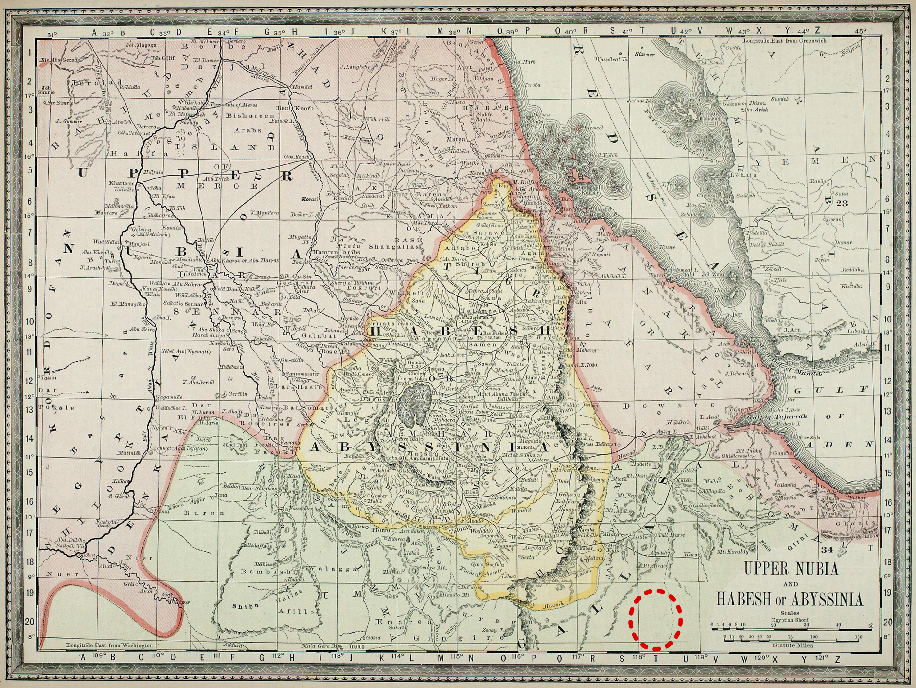
1882 map entitled “upper Nubia and Habesh or Abyssinia” (Rand McNally and Company, 2016). The dashed oval is our own addition and marks the approximate location of the Bale Mountains. Note: “Galla” was a pejorative term used to refer to the Oromo until the 1980s (Østebø, 2011).
Imperial Abyssinia (and some Western observers) justified the conquest, in part, through a series of myths which came together to produce what some scholars have termed the “Ethiopianist” (or even “Euro-Abyssinian”) colonizing structure (Megerssa, 1993; Megerssa and Kassam, 2020). Among these myths is the image of a “Greater Ethiopia,” which conflated the newly acquired territories of the conquest with the much larger region of ancient Cush via the shared name “Ethiopia,” which the Abyssinian elite adopted in the early 20th century (Hussein, 2005; Megerssa, 1993). The image of Greater Ethiopia is closely tied to Emperor Haile Selassie (1892–1975), who took the colonial policies of Menelik II and applied them throughout the country as part of his modernization project, including an attempted centralization and “Abyssiniazation” of the empire under a single Ethiopian identity (Blanc and Morrison, 2022; Hussein, 2005). This went hand in hand with state historiography portraying the Oromo as violent newcomers to the region, having pushed their way into the highlands from southeastern Ethiopia, Kenya, or even outside of Africa during the 16th century (Hassen, 2017; Megerssa and Kassam, 2020).
The image of Greater Ethiopia intersected with another myth, this time from medieval Europe, of a Christian priest-king named Prester John who ruled an isolated Christian civilization in Africa. Over time, this idea fused with the Abyssinian tradition that links its royal lineage to King Solomon and the Queen of Sheba of the Old Testament Bible (Hussein, 2005; Megerssa and Kassam, 2020). By locating the ancient European myth of Prester John in one of their own emperors, the Abyssinian elite of that time laid the foundation for a national narrative centered on an ancient near-eastern civilization that was culturally separate from the rest of Africa (Huber, 2020; Megerssa and Kassam, 2020).
This narrative was highly successful in shaping the image of Ethiopia, both within and outside the empire. 2 Bekerie (2004) argues that throughout the 20th century, Ethiopia served as an emblem of power, independence, and “civilization,” particularly for the African diaspora (see, e.g. DuBois, 1935). 3 For example, the African-American historian William Leo Hansberry referred to ancient Ethiopia as the “original Eden of humankind” (Hansberry and Johnson, 1964: 31). These ideas continue to be a source of confusion and contestation within and outside the country today (Hussein and Ademo, 2016; Kelecha, 2023; Østebø, 2020). 4
The particular notion of an “African Eden” also underlies longstanding environmental degradation narratives in Ethiopia (Blanc, 2018; Hoben, 1995). Much of these hinge on the idea that about 40% of the country's highlands were forested at the turn of the century, a percentage which has since plummeted to single digits. This figure is commonly cited in the framing of environmental policy and scientific research on land change throughout the highlands, including the Bale Mountains (e.g., Dejene et al., 2019; Evangelista et al., 2012; Shiferaw and Suryabhagavan, 2019; Young et al., 2020).
Many of these ideas are increasingly challenged. Rather than a single unbroken-ancient-civilization-turned-multiethnic-nation-state, many scholars argue that modern Ethiopia was invented, both from within and outside (Holcomb and Ibssa, 1990; Megerssa and Kassam, 2020). While a major 16th century Oromo expansion from Bale did occur, some scholars argue that the Oromos had been migrating, interacting, and competing for territory with the Abyssinians and other groups in East Africa for centuries prior (see Hassen, 2017). Bekerie (2004) notes: “Contrary to the popular belief that describes the Oromos as sixteenth century migrants and settlers in the Ethiopian Highlands, the Oromos appeared to be as ancient and indigenous, as the Amharas, the Agews, the Tigreans, and the Beja” (p. 116). Ideas about an African Eden covered in lush primary forests have also been thoroughly critiqued (Blanc and Morrison, 2022; Davis, 2005; Fairhead and Leach, 1996), 5 and historians have shown that the figures of 40% forest cover and its loss in Ethiopia were invented by international experts in Addis Ababa in the mid-20th century (Blanc and Morrison, 2022; McCann, 1997). Indeed, the extent and timing of deforestation in Ethiopia is increasingly questioned and even outright contradicted through closer inspection of historical datasets (Augenstein and Nyssen, 2021; Boerma, 2006; Meire et al., 2013; Nyssen et al., 2009, 2014; Wøien, 1995).
These challenges are bolstered by recent research in the Bale Mountains. The alpine plateau was recently found to be home to hunter-gatherers between 47 and 31 thousand years ago, making it the world's oldest prehistoric high-altitude area occupied by humans (Ossendorf et al., 2019). At least 2000 years of anthropogenic burning and grazing have influenced the modern vegetation structure and tree line (Gil-Romera et al., 2019; Johansson and Granström, 2020). The nearby Harenna Forest contains burial sites, stone megaliths, and structures of unknown origin (Chiodi and LeFevre, 2007; Chiodi and Pinard, 2011a). Remote sensing analyses of BMNP show a net forest cover change of −7.8% between 1987 and 2015, lower than the national average (Young et al., 2020).
Biophysical homogenization via the category of the “highlands”
The complex geography and contested historiography of Ethiopia have contributed to much confusion surrounding the notion of its “highlands,” even as the term was first being taken up in the scientific literature (see Wolde-Mariam, 1988). From a geological perspective, Ethiopia sits at the triple junction of the Nubian (or African), Somalian (or Somali), and Arabian tectonic plates, which are pulling away from each other (Figure 2). The region generally referred to as the Ethiopian Highlands was created from a geologic dome that formed during a massive outpouring of lava and was subsequently uplifted by tectonic forces. About 30 million years ago, the Arabian Plate separated from the African continent, and about 10 million years ago, the Somalian Plate began rifting from the Nubian Plate, creating the Rift Valley in between (Abbate et al., 2015). This process split the Ethiopian volcanic dome into separate plateaus, with the Simien Mountains as the highest area in the north and the Bale Mountains as the highest area in the southeast (both reaching elevations above 4200 m asl).
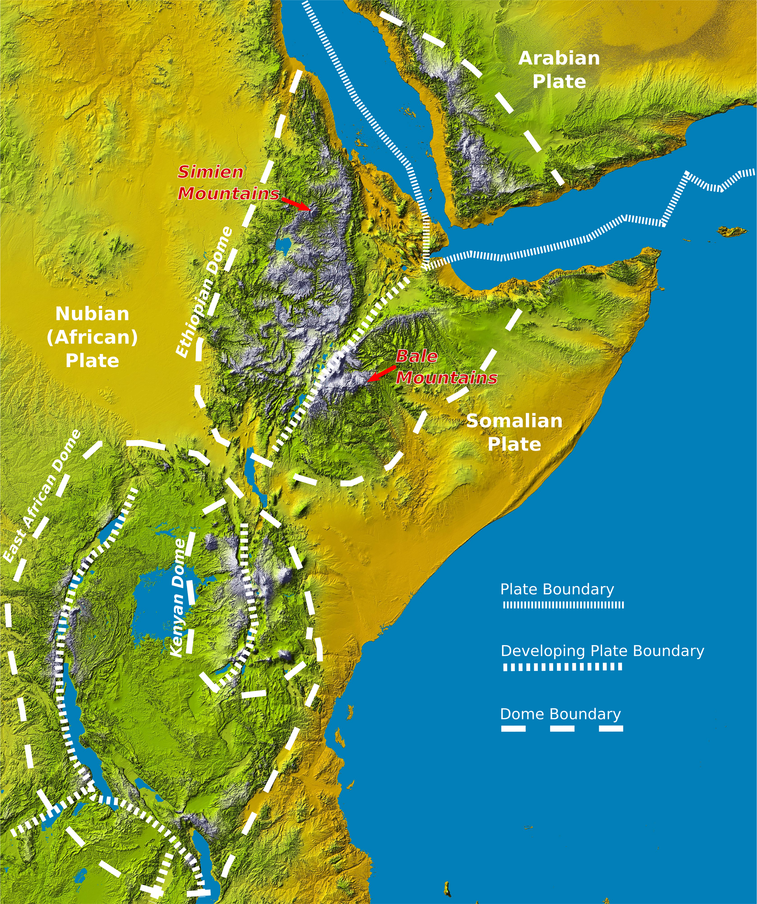
Topographic map of east Africa showing locations of the Simien Mountains and the Bale Mountains. The basemap is a color-shaded relief map of Africa produced by the Shuttle Radar Topography Mission digital elevation model (NASA/JPL-Caltech/NIMA, 2004). Tectonic plate boundaries, elevated dome boundaries, and large lakes of East Africa are also included (Adapted from Guth, 2013 Figures 2.1 and 2.2).
When conservationists began describing the Bale Mountains and framing its environmental challenges during the 1960s–1980s, many labeled and characterized the landscape as a “remnant” forest that was highly susceptible to processes of soil erosion and land degradation observed in the north. This has largely continued to the present day. As we will show, this was often based simply on the idea that the Bale Mountains were part of the Ethiopian Highlands. However, this stood in stark contrast to earlier and contemporary geological, climatological, and ecological studies that depicted and labeled the landscape very differently.
For example, early geologists and geographers referred to these plateaus based on their dominant people groups. Nilsson (1940) discusses the “Abyssinian” (northern) and “Somali” (southeastern) plateaus. Allen (1943) refers to the southeastern mountains as the “Somali Escarpment.” Smeds (1965) distinguishes the “Habesh” (i.e., Abyssinian) (northern), “Caffa” (central), and “Galla-Somali” (southeastern) plateaus. Mohr (1971) refers to the Ethiopian Highlands as being split between the “Ethiopian” (northern) and “Somali” (southeastern) plateaus, and even notes that “the political empire of Ethiopia does not in itself comprise a geological unit.”
The northern and southern highlands of Ethiopia share many characteristics. They are formed from the same volcanic dome, experienced periodic glaciation during the Pleistocene, and are the sources of numerous rivers of local and international importance. They also provide habitat for many shared or similar endemic species of plants and animals and have long histories of human settlement and activity. However, there are also significant differences between the regions.
Geologically, perhaps the most important difference is that the bulk of the Bale Mountains is comprised of a volcanic complex formed during the Plio-Quaternary periods (Abbate et al., 2015; Berhe et al., 1987; Rooney, 2020). In other words, in contrast to the Simien Mountains, the Bale Mountains experienced additional volcanism postrifting, with recent (2.1 (±0.5) to 1.61 (± 0.03) Ma) lava flows, cones, and plugs sitting on top of the older flood basalts of the split Ethiopian dome and the later shield volcanics (Abbate et al., 2015; Kebede, 2013; Nelson et al., 2019). This results in the Bale Mountains having a geologically younger and much less dissected landscape than Simien and much of the northern highlands. Young volcanic landscapes with incipient drainage networks are highly permeable, and thus groundwater (as opposed to surface-water) drainage is often a dominant hydrologic process (Guzha et al., 2018; Jacobs et al., 2018; Jefferson et al., 2010, 2014; Tague et al., 2008). The little hydrologic information that does exist suggests this may also be the case for the Bale Mountains (Chignell et al., 2019).
The northern and southern highlands also have very different geomorphic and climatic histories. From this perspective, the Bale Mountains are more similar to Mt Kenya and Mt Kilimanjaro, the other large volcanoes on the Somalian Plate, than to northern Ethiopia. During the Pleistocene, the Bale Mountains were wetter and cooler than the northwestern plateau, despite their lower latitude and altitude (Grab, 2002; Hendrickx et al., 2015). Although the Simien Mountains once possessed some valley glaciers, the Bale Mountains were the largest glaciated area in Africa during the Pleistocene, with ice covering about 265 km2 (Groos et al., 2021). This history was recognized as far back as Messerli et al. (1977), who note that the glaciated area was so vast that it created its own climate, and showed a closer relationship to Mt Kenya than to the neighboring Ethiopian high mountains. The Bale Mountains and Mt Kenya also share similar periglacial processes, indicating they had similar climatic conditions during the last ice age (Messerli and Winiger, 1992).
The modern climate also differs significantly between the northern and southern highlands. Parts of the north like the Simien Mountains have an extremely dry unimodal climate, while the Bale Mountains are bimodal and relatively moist (Bussmann, 2006; Bussmann et al., 2021). Relatedly, the flora in the Bale Mountains is transient between East Africa and drier northern Ethiopia (Bussmann et al., 2021; Gashaw and Fetene, 1996; Weinert, 1983). Indeed, the Bale Mountains are known for their rivers and greenness, and the Harenna Forest is often classified as a cloud forest.
These differences in paleo- and present-day climate and their interactions with geologic, topographic, and hydrologic factors suggest that the younger landscapes of the Bale Mountains are much less susceptible to soil erosion and degradation processes than their neighbors to the north. This was apparently recognized by the Derg, Ethiopia's Marxist-Leninist government of the 1970s–1980 s, 6 which did not classify the Bale Mountains as drought-prone or in need of soil and water conservation measures (Mekuriaw et al., 2018, Figure 1; Relief and Rehabilitation Commission, 1985). It was also recognized by some prominent Ethiopian and foreign scientists at the time (see Egziabher, 1988; Hurni, 1983b).
It is also important to consider the vastly different histories of land use between the regions. The Simien Mountains were settled by farmers at least 2000 years ago (www.simienmountains.org), while the Bale Oromo were traditionally pastoralists, not agriculturalists (Østebø 2020). Agriculture was hardly practiced in BMNP until the 1980s (Fiona Flintan, unpublished data) and largely came to southern Ethiopia through the expansion of Abyssinian imperial rule during the first half of the 20th century (Egziabher, 1989). This continued into the Derg era, which implemented massive resettlement and villagization campaigns, setting up large state farms, as well as peasant farmer associations in line with Marxist agrarian ideals. We take up these political-economic changes and their intersections with epistemic factors more fully below.
The twin birth of Ethiopia's highland national parks
The collapsing of the northern and southern highlands into a singular region was highly influenced by emerging alliances between Western conservationists and the Ethiopian government. International development and conservation organizations, particularly the United Nations Educational, Scientific and Cultural Organization (UNESCO) and the International Union for the Conservation of Nature (IUCN), began working in the 1950s–1960s with the Ethiopian imperial government to develop a framework for conservation in the country (Huber, 2020). A key actor was Leslie Brown, a British naturalist trained in ornithology and agriculture who had worked as an agricultural advisor in colonial Nigeria and Kenya since 1940 (Blanc and Morrison, 2022). Having established himself as an expert for international conservation organizations across East Africa, he visited the Simien Mountains in 1963 at the invitation of the Ethiopian government to help create a network of protected areas (Blanc, 2018). Following this trip, Brown noted that “Ethiopians are without exception the most destructive human beings I have seen—utterly feckless and without any regard for the future” (quoted in Blanc, 2018: 17).
Soon after, Brown took a 12-day trip in the Bale Mountains as part of a National Geographic expedition to assess the status of the Mountain Nyala, an endemic species of antelope. At this time, foreign writers knew little about the region, stating that “the Bale plateau is in every respect terra incognita” (Smeds, 1959: 218) and “one of the areas of Ethiopia still least known to the outside world” (Busk, 1957: 71). 7 Brown (1966) indicates that the area was hardly known even to the Ethiopian imperial government. Brown also saw the Bale Mountains as a “Garden of Eden” and perceived pastoralists as much less destructive than agriculturalists (see Flintan et al., 2008). As one of the first major written accounts of the Bale Mountains, Brown's 1966 report served as the basis for later research on the region and contains one of the first (if not the first) written instances of it being explicitly categorized as part of the Ethiopian Highlands. The establishment of Simien Mountains National Park (SMNP) and BMNP occurred a couple of years later in 1969–1970, but the latter was not officially gazetted and its legal status remained unclear. During this time, Brown continued developing Ethiopia's conservation programs and communicating them to the international conservation community (e.g. Brown 1967; 1969a; 1969b). This took place within the context of an increasingly internationally focused Ethiopian central government, and its desire to shore up control of its rebellious “peripheries” (which included both Simien and Bale) while curating the image of the empire to the rest of the world (Blanc, 2018; Huber, 2020).
Brown distilled his ideas in a short book entitled Conservation for Survival: Ethiopia's Choice (Brown, 1973), in which he laid out what he understood to be the major problems of and solutions to environmental degradation in Ethiopia. These were largely based upon assumed relationships among agriculture, forests, wildlife, and a growing peasantry: “In Ethiopia, even high mountain ranges, which should not be cultivated or inhabited anywhere in the world, are densely inhabited and cultivated, and this poses particularly severe problems in Semien” (Brown, 1973: 44). Brown goes on to predict that pastoralists would become agriculturalists in the coming decades and thus bring the same degradation that he observed in the north to the south. As a result, he strongly advocated for the imperial government to use its power to declare protected areas in places where government control was lacking, specifically BMNP. If national park status could be enshrined in law, he urged, local people could simply be removed from the area. Brown's ideas were instrumental in the development of modern conservation education, policy, and practice in Ethiopia (Tedla, 1994).
Many of the same actors involved in early descriptions of the scientific and conservation assessment of BMNP were also intimately involved in the creation of SMNP. 8 Leslie Brown conducted initial assessments of both areas, for instance, and Swiss geographer Hans Hurni served as warden of SMNP, drafted its first management plan, and conducted some of the earliest geomorphological research in BMNP (Messerli et al., 1977). Hurni later went on to become a key figure in the development of the “Ethiopian Highlands” literature in the 1980s and its associated soil and water conservation projects. The twin birth of SMNP and BMNP, facilitated by a small group of foreign experts, initiated a long-standing tendency to conflate the landscapes, peoples, and concerns of the northern highlands with those of the southern highlands, a pattern that emerges again in explanations of famines in the latter half of the 20th century.
Famine as weapon and catalyst for scientific research: Reifying the “Ethiopian Highlands”
Following the overthrow of the Ethiopian imperial government in 1974, the Derg initiated sweeping reforms, organizing massive resettlement and villagization processes. They associated the imperial past with the soil degradation and famine experienced in some areas during the 1960s and 1970s, particularly in the northern highlands (Egziabher, 1989). They also initiated government interventions to combat environmental degradation, and between 1976 and 1985 large-scale soil conservation and afforestation measures were implemented by rural peoples with the support of external aid (Hurni, 1988a). While the Derg government was heavily invested in restoring “degraded” land in parts of the highlands it considered under its control, it was out on a clear campaign of destruction in other parts of the country where populations were considered disloyal. The Derg used the creation of national parks as a tool to crush opposition, including in Simien, which had become a hotbed of resistance (Blanc and Morrison, 2022). In 1983–1985, a major famine occurred in northern Ethiopia that left 1.2 million people dead, 400,000 refugees outside the country, 2.5 million people internally displaced, and almost 200,000 children orphaned (Giorgis, 1989). The official cause was land degradation followed by drought, but many observers argued that the government's strategies for fighting insurgents in the region, which included withholding food as a weapon against Tigray and Eritrea (Tsighe, 1995), was the more important factor (De Waal, 1991).
In response to the famine, the Ethiopian government, with the support of international nongovernmental organizations (NGOs) and donors (e.g., the 1985 live aid fundraising concert), launched an ambitious program of research and development efforts aimed at making Ethiopia's highlands more resilient to drought and degradation (Hurni, 1983a; Hurni and Messerli, 1981; Yalden, 1983). This coincided with the First International Workshop on African Mountains and Highlands held in Ethiopia in October 1986 (Hurni, 1988b). The event was supported by the United Nations University, UNESCO, and the Universities of Addis Ababa (Ethiopia) and Bern (Switzerland), with the goal of drawing international attention to understudied African mountains (Messerli, 1988). As part of the workshop, “a four-day field trip through the Ethiopian Highlands and mountains, in the regions of Northern Shewa and Welo [a historical province of northern Ethiopia], directed the participants’ attention to environmental degradation, soil erosion, and socio-cultural problems, which are all contributing to Ethiopia's well-known vulnerability to famines” (Messerli, 1988: 89).
These themes and the implied causal relationships among land use, drought, degradation, and famine permeate the subsequent special issue published in the journal Mountain Research and Development (see Egziabher 1988; Gamachu 1988; Hurni 1988a; Wolde-Mariam 1988). 9 While most of the special issue focused on the country's northern highlands, two papers focused on the Bale Mountains in the south (Hillman, 1988; Uhlig, 1988). Both categorize the region as part of the Ethiopian Highlands, and explicitly connect it to processes of environmental degradation observed in the north of the country.
Bibliometric trends show that the publication of this special issue marks the beginning of significant academic research on the Ethiopian Highlands (Figure 3). Since 1988, production has steadily increased, with nearly 250 articles published in 2021 alone. This is characterized by increasing collaborations among Ethiopian and international (primarily European) scientists. The most locally cited journal in the corpus is Land Degradation and Development, followed by Journal of Hydrology, Catena, and Agriculture, Ecosystems & Environment (Supplemental Figure S1). The 10 most commonly occurring author keywords include terms like “soil erosion,” “land degradation,” “soil and water conservation,” “land use,” and “northern Ethiopia” (Supplemental Figure S2). Nearly all of the top 20 most locally cited documents in the corpus are focused on Tigray and the northern highlands, while none are focused on the southeast (Supplemental Figure S3).
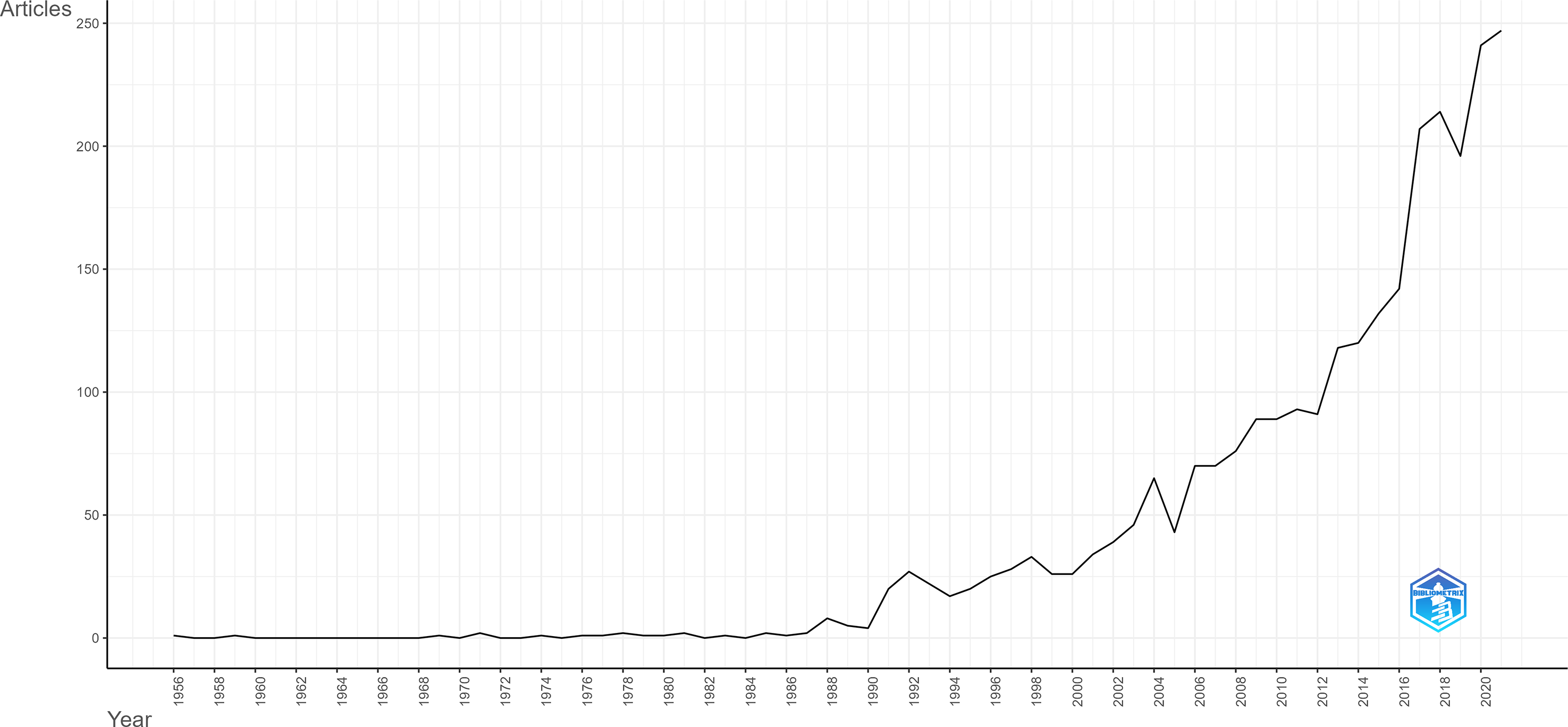
Number of publications on the “Ethiopian Highlands” over time. We acquired the bibliometric data by querying the Web of Science Core Collection, on the “Topic” field, which searches Title, Abstract, and Keywords. We analyzed the results using the R package bibliometrix (Aria and Cuccurullo, 2017) and the associated biblioshiny app (Aria and Cuccurullo, 2020). See Supplemental Material for additional details and bibliometric results.
Importantly, this bibliometric analysis indicates that academic understanding of the “Ethiopian Highlands” is closely associated with—if not defined by—ideas around human-caused land degradation in northern Ethiopia. These ideas were used by the Derg government to increase control over rebellious areas in the north like Simien, and later applied to the Bale Mountains by Jesse Hillman and others in the 1988 special issue on the Ethiopian Highlands. Hillman, an American, had been advising the Ethiopian Wildlife Conservation Organization (Blanc and Morrison, 2022), including making recommendations about SMNP and serving as warden of BMNP. Writing to the East African Wildlife Society in 1985, he connects the drought and famine in northern Ethiopia to his own observations in BMNP (Hillman and Hillman, 1985). A year later, Hillman's (1986a) management plan for the park opens with a quote from Mengistu Haile Mariam, then-leader of the Derg government: If we look back to some of the regions of our country that are affected by drought repeatedly, the cause is directly related to the deterioration of our forest, soil and water resources. Particularly the drought that has affected our northern regions in the past, and which resulted from the deterioration of farming resources, is also expanding to the other regions at an alarming rate today. Human tragedies, such as famine and drought in Africa or floods in Asia, are misnamed 'natural disasters'. They can be directly attributed to environmental degradation by man.
These quotes and the broader trends revealed by the bibliometric analysis illustrate how the Bale Mountains became conceptually tied to real and assumed processes occurring in SMNP and the northern Ethiopian Highlands. As a result, concerns over environmental degradation became an increasingly dominant part of the framing of BMNP. This is both a product and reflection of a broader “neo-Malthusian environmental policy narrative that was used by governments and donors to justify the rapid, massive and widespread use of standardized environmental management ‘packages’ without research on their environmental impact or their economic costs and benefits” (Hoben, 1995: 1007). Indeed, the Derg used the international community's fear of famine to justify its resettlement and villagization program, exaggerating the level of degradation in order to gain support for its resettlement campaign (Wøien, 1995).
The national villagization program was first implemented in Bale in 1978, which subsequently served as a model for the expansion of the program to other regions (Clay, 1988). The Derg did not trust Oromos in southern Ethiopia, partly due to the Bale Insurgency of 1963–1970, in which thousands of fighters used the Harenna Forest as a base for guerrilla warfare against the imperial government (Østebø, 2020). People living in isolated or rugged terrain or areas controlled by the Oromo Liberation Front (an armed rebel group) were villagized while the government resettled 15,000 agriculturalists from the north to Bale, and armed them to secure the rural areas (Clay, 1988). Foreign humanitarian agencies offered help, a well-intentioned “parachute” operation which the Derg used to their advantage. While “publicly, the government claimed that the purpose of the villagization program was to secure and organize the population so that the effects of war and drought-induced famine could be more easily alleviated through the central distribution of assistance,” the Derg government actually “established the new villages in Bale in order to keep the population under surveillance and secure the area under central government control” (Clay, 1988: 147). This process enabled the government to set up commercial farms while controlling movement and rebels in peripheral areas. Reflecting on the results of the national resettlement plan, Woube (1995) notes, “most of the resettlement schemes have not succeeded in improving the basic necessity of life; rather, they have led to environmental degradation” (p. 87).
BMNP was shaped by these processes. Hillman's (1986a) management plan recounts a meeting that took place regarding the park's management: “one of the advantages of villagization the First Secretary pointed out, was the favourable conditions now existing for the protection and conservation of forestry and wildlife” (Hillman, 1986a: ix). Two years later, in his article in the special issue, Hillman also shows cautious optimism for the villagization program due to its potential to protect the natural resources and wilderness aesthetics of BMNP (Hillman, 1988). While Hillman's recommendation was to regulate—not exclude—human activities in the park, both the Derg government and its successor the Ethiopian People's Revolutionary Democratic Front (EPRDF) decided on no human settlement in national parks (Blanc and Morrison, 2022; Flintan, 2000; Nelson, 2011). This followed recommendations from some Western experts for the “extinguishment of all human rights” in SMNP, bringing Ethiopia's national parks in alignment with UNESCO's definition of natural heritage (Blanc and Morrison, 2022: 103). Facilitated through a network of international experts—many with ties to British colonial institutions—the creation of BMNP was, in one sense, a win-win: the Ethiopian imperial government (and later the Derg) tightened control over a rebellious territory and its resources and secured the promise of foreign income through natural heritage tourism, while the international conservation community got the protection of a “pristine” biodiversity hotspot. Of course, the losers were the people living in and around BMNP, who were resettled outside the boundary of the park.
The perpetual “threat” of anthropogenic environmental degradation in the Bale Mountains
Following the overthrow of the Derg and the establishment of the Tigrayan-led EPRDF in 1991, many people living in the Bale Mountains (re)settled areas within and around the boundaries of BMNP (Tadesse et al., 2011). In doing so, some killed wildlife, presumably as a backlash at the park administration for years of “fortress”-style conservation (Gottelli and Sillero-Zubiri, 1992; Woldegebriel, 1996). These actions concerned many conservationists, as they worried the park's unique biodiversity would be permanently lost due to grazing, farming, and deforestation (Tadesse et al., 2011). Soon after, the degradation narrative from the north reappeared in the science, conservation, and development literature on BMNP. This is evident in the early work of the Ethiopian Wolf Conservation Program: Today, the highlands of Ethiopia are among the most densely populated agricultural areas within Africa … the problems of habitat destruction, soil degradation and high population pressure are persistent; they are concentrated in the north of the country but are spreading south rapidly. (Gottelli and Sillero-Zubiri, 1992: 209, emphasis added)
This quote is repeated nearly verbatim five years later in an IUCN report on the Ethiopian wolf, alongside an image of “degraded” mountains in the Amhara region (Sillero-Zubiri et al., 1997: 27). This north–south connection and conflation continued into the 2000s (e.g. van de Veen, 2000), and appears over a decade later in a special issue on BMNP in the Ethiopian journal Walia (Fial, 2011). It continues to frame the science today, as a recent study of forest change and trajectories in the Bale Mountains notes: Ecosystem change is more severe in the highlands of Ethiopia (Eshetu and Hogberg 2000). This is due to the result that these areas were characterized by high population pressure and cultivated for long period of time (Kindu et al. 2013). (Mezgebu and Workineh, 2017: 2)
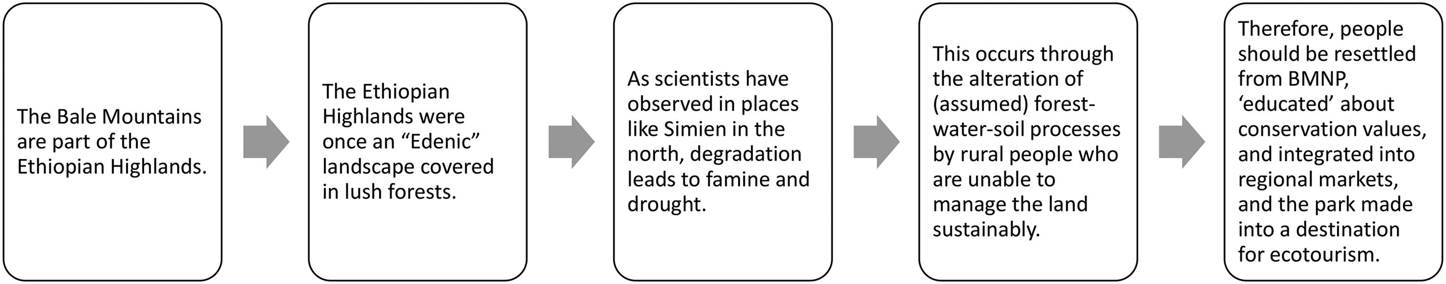
Chain of reasoning underlying the scientific research and related policy on human impacts in Bale Mountains National Park (BMNP).
Why is this thought process so pervasive and persistent? How has the category of the “Ethiopian Highlands” and its conceptual baggage come to be so effortlessly stretched to subsume the particularities of the Bale Mountains? We suggest two possible reasons: (1) an information vacuum created by the Ethiopian Empire and (2) a conceptual melding of the metaphor of the Ethiopian Highlands as a geopolitical “island” and the Bale Mountains as an ecological “island.”
In the shadow of empire: An information vacuum and the inflow of international expertise
The scientific and conservation literature generally attributes the lack of historical information about BMNP to its remoteness and ruggedness. However, the Ethiopian imperial government had strictly forbidden any European to enter the area during the turn of the 20th century (Neumann, 1902). For example, the American explorer and physician Arthur Donaldson Smith describes how Menelik II and his governors repeatedly blocked his exploration party from visiting the Bale area, at least until the “Gallas” (Oromos) had submitted to his army (Figure 5). Interestingly, Smith notes that the imperial general who forced him to return to Addis Ababa “was most anxious that I should carry with me to Europe good reports of himself and the Abyssinians” (Smith et al., 1897: 107). This can be interpreted as part of a historical pattern of Ethiopian government leaders seeking external support in order to justify and secure their internal control of Ethiopia (Blanc, 2018; Huber, 2020).
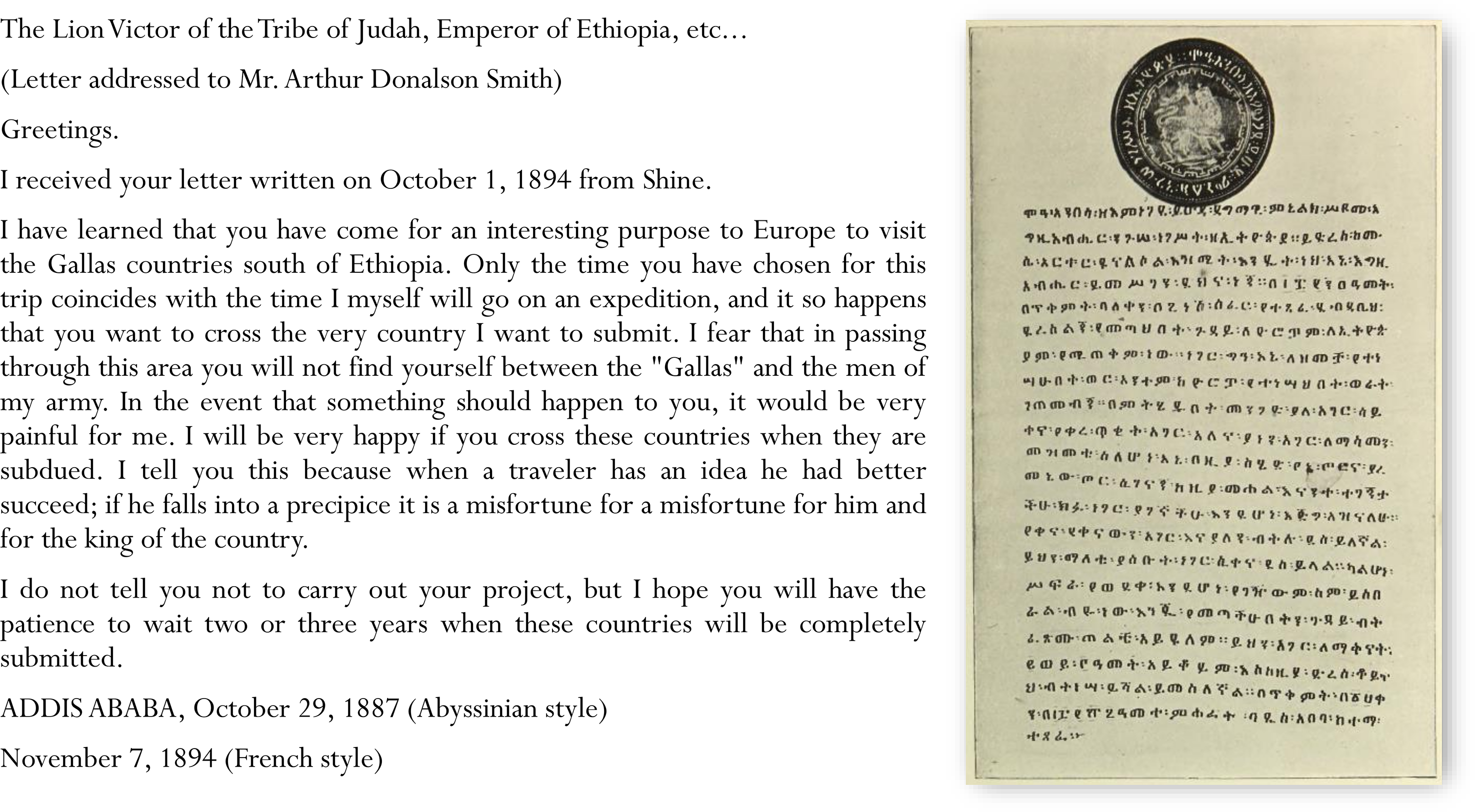
Letter from Ethiopian Emperor Menelik II to American explorer Donaldson Smith
The lack of preexisting maps or written knowledge (in part due to decades of suppression of Oromo language and history) meant that foreign experts in the mid-20th century were left to rely on their own preconceptions and those of their government guides and interpreters. However, on occasion, glimpses of the pre-imperial history flicker into view in their writings. For example, Herbert Mooney, working as a forestry adviser with the British Middle East Development Division, visited the Harenna Forest on behalf of the Ethiopian imperial government. He reports well-used tracks and many signs of former forest clearings, concluding: I am convinced that there was formerly a larger population in these parts [southern edge of Harenna], possibly seventy or eighty years ago. The decline may have been due to the Galla wars of that time or to epidemics among the people or cattle. (Mooney, 1963: 140)
Three years later Leslie Brown notes: “I have been informed that little or none of this land is actually owned by anyone on a secure basis” (Brown, 1966: 76). Not questioning or stating the reasons why this was the case further obscures the history of the Bale Mountains and its inhabitants. This is perpetuated in Hillman (1988): “The southern escarpment and forest area was depopulated towards the end of the last century (possibly the result of smallpox and/or rinderpest)” (p. 255). Given that Hillman cites Mooney's work in the same paper, it is notable that he attributes the depopulation of the areas solely to disease, not conquest.
The image of a largely pristine and uninhabited region at risk of degradation from a rapidly growing population of (agro-)pastoralists arguably helped to justify the park's existence. 10 Over time, terra incognita (unknown land) became terra nullius (nobody's land), concepts long-used by European empires and later the Ethiopian state to justify the removal of pastoralists on communal lands in order to set up protected areas and large-scale commercial farms for foreign export (Abbink, 2011; Kloos, 1991; Makki, 2018; Regassa et al., 2019).
The Ethiopian Highlands as geopolitical island
There is another, subtler process at work which makes the Ethiopian Highlands such a powerful category in BMNP, and it relates to a blending of late 20th-century natural history and ecological science with the older Ethiopianist narrative. Specifically, this relates to the conception of Ethiopia as an ancient Christian civilization, isolated in its mountain highlands and surrounded by its “frontiers” (i.e., Greater Ethiopia). Tibebu (1995) argues that the image of Ethiopia as a “Christian island surrounded by a heathen sea” (p. 49) was central to the creation of modern statehood and Ethiopian identity. In the 1960s–1970s, Ethiopian elites and foreign experts enrolled these ideas in the development of the nation's heritage and tourism industry: The emerging fields of cultural and natural tourism, as well as the travel and exploration activities of foreign experts posted in Ethiopia, resulted in a growing number of publications and reports during the 1960s and 1970s. The most important common feature in these reports of Ethiopia was the presentation of a non-African, ancient empire …. This was employed to explain Ethiopian culture's quality as a civilization, to which one could ascribe a certain superiority and even supremacy. (Huber, 2020: 64)
This image solidified the Ethiopian Empire cum Ethiopian state's territorial claims through the demarcation and protection of “Ethiopian” natural and cultural heritage, of which the highlands were one of its most valuable assets (Huber, 2020). As discussed previously, along with SMNP, BMNP was one of the empire's original proposed natural heritage sites during this period.
We can trace the presence of these ideas in the way Ethiopia is presented in the international scientific literature throughout the latter half of the 20th century. For example, a 1956 article published in The Professional Geographer describes the newly formed Imperial Ethiopian Mapping and Geographical Institute (now the Ethiopian Mapping Authority), a cooperative project of the Governments of Ethiopia and the United States: Ethiopia, the only country that remained independent in the whole of Africa,
The author, Mesfin Wolde-Mariam, went on to become one of the major architects of conservation in Ethiopia (Kingdon, 1990), and was one of the first to attempt a scientific definition of the extent of, and stressors on, the Ethiopian Highlands, published as part of the 1988 special issue in Mountain Research and Development (Wolde-Mariam, 1988). The Ethiopian Mapping Authority would go on to produce the first detailed topographic maps of the country's highlands, including the Bale Mountains, which were used by Hillman in the demarcation of BMNP (see Hillman, 1993).
The image of “island” Ethiopia continued into the Derg period. The well-known Tigrayan biologist Tewolde Egziabher, writing on the causes of environmental degradation in Ethiopia asserts: As the rest of the world, with whom Ethiopia had in the past been interacting, progressed scientifically, technologically, socially and politically,
Egziabher went on to become a major figure in Ethiopian environmental policy. After the fall of the Derg in 1991, the new government officially transitioned from “fortress” conservation to a new era of “participatory” conservation. However, the old Ethiopian narrative continued to frame such work. For example, a paper by the manager and head of the Ethiopian Wildlife Conservation Organization presented in Venezuela at the IV World Congress on National Parks and Protected Areas begins: Ethiopia has a magnificent and glorious past. One of the oldest states in the world, she has seen 3000 years of statehood under 322 monarchs (Taye, 1972). The Holy Bible makes more than 40 references to Ethiopia (Yemesehaf kidus Mezgebe Kalat, 1980) and Homer refers to her people in The Iliad (Hess, 1970
Ecological islands and strongholds
As ideas about the Ethiopian nation and its highlands as constitutive of an ancient, unified civilization were being woven into the country's environmental science and policy, elsewhere, ideas from island biogeography were being adapted by scientists seeking to explain the biodiversity of the world's mountains. In Ethiopia, this took the form of scientific and conservation work reemphasizing an image of uncultivated mountain landscapes (such as BMNP) as, once again, Edenic and unspoiled. 11 In doing so, scientists and conservationists transformed the existing notion of the “highlands”—in the Ethiopianist sense of the word—to a more acceptable ecological metaphor: “island,” to refer to mountain biodiversity.
A key example is the book Island Africa: The Evolution of Africa's Rare Animals and Plants, a continental-scale natural history which reconceptualized Africa's pockets of endemism as land-locked islands (Kingdon, 1990). The Ethiopian Highlands are a key case study of the book, and several pages are devoted to BMNP: “The finest and most intact remnant of Ethiopia's original vegetation is contained within the proposed National Park of Bale” (Kingdon, 1990: 150). By “original,” Kingdon presumably refers to the prehuman “natural” woodlands and forests which are assumed to have covered nearly half of Ethiopia, but were “annihilated” by 2000 years of agricultural expansion. 12 Kingdon goes on to suggest that conservation and environmental organizations in Africa “…represent the response to a sudden reversal whereby humans, once islanders in a sea of wild things, are now the sea around islands of wilderness” (Kingdon, 1990: 250). Since its publication, the book has served to explain the Bale Mountains’ distinctive endemic fauna and flora and is regularly cited in the region's ecological and conservation science literature (e.g., Eggermont et al., 2011; Gottelli and Sillero-Zubiri, 1992; Reber et al., 2018; Sillero-Zubiri and Gottelli, 1995; Umer et al., 2007).
This coincided with increasing scientific interest in “sky islands,” defined as “high-elevation habitats that are geographically subdivided and isolated among different mountain ranges” (McCormack et al., 2009: 839). This term was originally coined by conservationists in the American Southwest and Northwestern Mexico (Heald, 1967; Howell, 1947), and later revisited by ecologists in the 1990s (DeBano, 1999; DeBano and bFfolliott, 1995). Scientists have subsequently used it to characterize and classify many tropical mountains throughout the world, including the Ethiopian Highlands and the Bale Mountains (e.g., Assefa et al., 2007; Wondimu et al., 2013).
Through repeated association with the language of mountain biodiversity and sky islands, the Ethiopian Highlands—a vaguely defined category emerging from a complex geopolitical history—became a scientific term through its use in biogeography, conservation, and ecological sciences. The metaphor of an Ethiopian “island”—whether an ancient Christian civilization or an ancient paleo-ecosystem, in a “sea” of “heathens” or a “sea” of arid lands and their supposedly destructive pastoralists—creates a simplified image of a vulnerable BMNP, which in turn gives way to metaphors like “stronghold” and “bastion” being applied to the region's flora and fauna.
BMNP in the Ethiopian wolf's clothing: Reifying greater Ethiopia's natural heritage
Throughout the 20th century, the image of “Greater Ethiopia” and its highlands continued to work in the minds of foreign scientists working under the auspices of the Ethiopian government in its southern territories. For example, the Ethiopian wolf (Canis simensis) is considered the “flagship” and most endangered species in BMNP. The rare canids live in several small alpine pockets across Ethiopia, understood as the remnants of much a larger range during the last ice age (Gottelli et al., 2004). Outside BMNP, the largest population lives in SMNP, and prior to the early 1990s, the animal was known as the “Simien Fox” or “Simien Jackal” by Western conservationists (Hillman, 1986b; Morris and Malcolm, 1977; Waltermire, 1975). In the early 1990s, genetic analyses showed that C. simensis is actually a distinct canid species (Gottelli et al., 1994). The English name was changed to “Ethiopian wolf” in a meeting of the IUCN Canid Specialist Group (Gottelli and Sillero-Zubiri, 1992), soon after the Bale Mountains were first conceptualized as a “highland island” (Hillman and Hillman, 1987). While the term “wolf” likely conjures up more exotic and positive associations than “coyote”—particularly in the minds of Western ecotourists and conservationists—genetically speaking, coyote would be an equally appropriate name as “wolf.”
More importantly, this example demonstrates the power of the terms used in BMNP: the shift from “Simien” to “Ethiopian” invokes the animal as a national heritage species, while the shift from “fox” or “jackal” to “wolf” puts it among the world's charismatic megafauna, making it universal heritage, and thus a more valuable asset for conservation and ecotourism. Indeed, despite it apparently having little historical cultural significance for Ethiopian peoples, the Ethiopian government soon began using the Ethiopian wolf and other endemic species as national symbols, including postage stamps (Sillero-Zubiri et al., 1997). Conservationists followed suit, calling it “a natural icon of the Ethiopian Highlands” (Sillero-Zubiri et al., 1997: vii).
Around this time, the scientific and conservation literature began referring to the Bale Mountains as the “stronghold” or “bastion” of the Ethiopian wolf (van de Veen, 2000), and even an “extreme south-eastern bastion of the Ethiopian Highlands, projecting against the Somalian lowlands” (Miehe and Miehe, 1994: 24). Through these metaphorical associations, BMNP came to be seen as an island stronghold—not only in an ecological sense (defending habitat)—but also a geopolitical sense (defending heritage). In both cases, the protagonists are the Ethiopian wildlife and their protectors (e.g., elites in Addis Ababa, foreign scientists, and NGOs), and the antagonists are the park's inhabitants and surrounding communities (e.g., mostly Oromo agropastoralists). The staying power of this vision helps to explain why—despite the official shift away from “fortress” conservation—top-down governance remains predominant, as park and government authorities use their power to decide how local communities should participate in BMNP management (Gulte et al., 2023). Limited economic benefits from the park, insecure land tenure and the constant threat of relocation, as well as the lack of formal support of customary institutions and management systems, have all contributed to local communities lacking incentives to invest in regulated resource use, while simultaneously lacking the power to prevent others from doing so (Flintan et al., 2017; Gulte et al., 2023; Tadesse et al., 2011). In this light, it is not surprising that BMNP has seen near-constant conflict and resentment among local communities and park management since its creation (Fial, 2011; Flintan et al., 2017; Woldegebriel, 1996).
The case of C. simensis is perhaps the most iconic example of how imperial legacies are embedded in the science and conservation of BMNP, but it is not an anomaly. For example, the website of the Ethiopian Wildlife Conservation Authority (https://ewca.gov.et/park/detail/7) lists several of the key wildlife species potential visitors can expect to see in BMNP, including the Abyssinian Blue-winged Goose, Abyssinian Catbird, Abyssinian Hare, Abyssinian Long Claw, Abyssinian Woodpecker, and Menelik's Bushbuck. Menelik's Bushbuck (Tragelaphus scriptus meneliki) is a type of antelope and was named by the German naturalist Oscar Neumann in 1902, following his expedition to southern Ethiopia immediately after its conquest. Reporting on the expedition in The Geographical Journal, Neumann states: “But in the first place, we have to thank the Emperor Menelik, that intelligent ruler and restorer of an ancient and great empire, for his help and permission to pass through his country” (Neumann, 1902: 374). With this context, we can see how connections among Ethiopia's imperial history, scientific knowledge production, and conservation practice have been formed and maintained in BMNP.
Synthesis and conclusions: Syllogistic reasoning enables and maintains “inscrutability” in the Bale Mountains
As we have shown, early and much successive scientific knowledge about BMNP was generated by outsiders to the area, working either with or for the Ethiopian Empire cum Ethiopian state. Their perceptions of the landscape and its peoples, influenced by longstanding Abyssinian narratives, European myths, and their own experiences in colonial British East Africa and northern Ethiopia, guided the questions they asked and the way they framed their work. This set the terms for the way the area would be perceived and studied in the decades that followed.
A key element of this is the idea that there was little human history in the region before the establishment of BMNP. The lack of information on historic maps reflected and reified an image of terra nullius, as did the lack of a written record since text-based knowledge is favored in Western sciences (Trisos et al., 2021). This contributed to the idea of the Oromo as a people without a history, which continues today; the park's website states: “Little is known about the Oromo people of the area and how they settled here” (https://balemountains.org). It also obscures other facts and frames by which to understand the Bale Mountains, particularly its hydrologic and sociocultural specificities. The particular geological setting of the Bale Mountains (i.e. young volcanic layers that are highly permeable and less prone to erosion) suggests a complex groundwater system that complicates typical assumptions about the “degrading” impacts of human settlement and livestock grazing. The unique cultural setting—as a homeland and place of pilgrimage with a long history of pastoral (not agriculturalist) use—challenges Western visions of a “pristine,” “Edenic” wilderness. The intersection of these biophysical, political-economic, and epistemic factors has arguably contributed to the enduring “inscrutability” of important sociocultural and hydrologic aspects of BMNP, as well as its embeddedness within a broader web of histories and meanings.
As a result, histories, names, and conceptual models from northern Ethiopia have been syllogistically and uncritically applied in the scientific and conservation literature about BMNP (Table 1).
How the notion of the “Ethiopian Highlands” facilitates syllogistic reasoning in the Bale Mountains.

Syllogism is a form of deductive reasoning which enables one to draw conclusions from a set of starting assumptions and is useful in the face of limited data. However, it can also lead to major errors if the emphasis on the logic (and its conclusions) outweighs the effort to verify the underlying assumptions. This is especially true if those assumptions support powerful agendas. The political-economic and epistemic factors at work in BMNP match the ways successive Ethiopian central governments have treated the country's peripheries—not just outside “Ethiopia proper” (i.e. Abyssinia)—but also within (e.g. SMNP).
Similar processes have been well-described by earlier scholarship in geography and political ecology, particularly on the production of environmental knowledge and ignorance (Goldman et al. 2011; Turner 2016), the relationship between the social construction of scale and the production of space (Marston, 2000; Marston et al., 2005), as well as the politics and subjectivity embedded in biogeography and land use categorization (Robbins, 2001; Robbins and Maddock, 2000; Sarmiento, 2012). This article elaborates on the causes and effects of these processes through the case of the Bale Mountains and shows how such reasoning contributes to the production of inscrutable spaces and circulations. In doing so, it addresses a key line of inquiry for the inscrutability literature, namely understanding how inscrutability evolves over time (Kroepsch and Clifford, 2022), and demonstrates the particular value of a genealogical approach for doing so.
While concerns over anthropogenic ecological changes in BMNP certainly warrant further research, it is the constant perceived “threat” which does the cognitive work; it not only justifies the resettlement of local communities and drives conflict over land and resources, but affects the production of scientific knowledge and its interpretation in subtle yet consequential ways. This is maintained because it matches the values and interests of actors in international conservation organizations and successive Ethiopian governments, who have sought to designate BMNP as a UNESCO Natural World Heritage site since 2009 (Berta, 2021). This was recently accomplished (UNESCO World Heritage Centre, 2023), fulfilling two major original functions of the park, which was a tool for the central government to increase its control over a rebellious area while raising Ethiopia's profile on the international stage and bringing “high value, low impact” ecotourists from the Global North willing to pay for a unique “Ethiopian” experience (Huber, 2020). Making this a reality is contingent on keeping national parks free of human settlement, bringing Ethiopian protected areas into alignment with the dominant values of Western conservationists and received wisdom about the causes and consequences of land degradation.
Thus, the category of the “Ethiopian Highlands” has served to reify an image of a “Greater Ethiopia,” which papers over the Abyssinian Kingdom's conquest in the late 19th century that led to the modern borders of Ethiopia. At the same time, it also undergirds and perpetuates a certain vision of BMNP through syllogistic comparisons of the northern regions to the southern regions. This framing obscures significant geologic, geomorphic, (paleo)climatic, sociocultural, and land use differences, which in turn hinders scientific understanding of the region and helps to perpetuate environmental and epistemic injustices that result in resentment, conflict, and poorer conservation outcomes.
Highlights
In Ethiopia, the category of the “Ethiopian Highlands” homogenizes the diverse biophysical and sociocultural features of the country's mountain landscapes.
Intersecting myths and the twin birth of Ethiopia's highland national parks facilitated the transposition of neo-Malthusian degradation narratives from north to south.
Imperial legacies created an information vacuum which was filled by the perceptions and assertions of a small group of international conservation experts.
Syllogistic reasoning via the “highlands” category and related metaphors maintains the hydrologic and sociocultural “inscrutability” of Ethiopia's southeastern mountains.
Supplemental Material
sj-docx-1-ene-10.1177_25148486231222621 - Supplemental material for One size fits all: How the “Ethiopian Highlands” made Bale Mountains National Park inscrutable
Supplemental material, sj-docx-1-ene-10.1177_25148486231222621 for One size fits all: How the “Ethiopian Highlands” made Bale Mountains National Park inscrutable by Stephen M. Chignell, Aishwarya Ramachandran and Terre Satterfield in Environment and Planning E: Nature and Space
Footnotes
Acknowledgments
We would like to thank Mark Carey for the thoughtful feedback on early versions of the manuscript. We also appreciate the helpful comments from three anonymous reviewers. Finally, we are grateful to Daisy Larios, Library and Publications Manager at the IUCN archives in Gland, Switzerland, for facilitating access to archival material.
Funding
The authors disclosed receipt of the following financial support for the research, authorship, and/or publication of this article: This work was supported by the Natural Sciences and Engineering Research Council of Canada (grant number 6565).
Notes
Supplemental material
Supplemental material for this article is available online.
References
Supplementary Material
Please find the following supplemental material available below.
For Open Access articles published under a Creative Commons License, all supplemental material carries the same license as the article it is associated with.
For non-Open Access articles published, all supplemental material carries a non-exclusive license, and permission requests for re-use of supplemental material or any part of supplemental material shall be sent directly to the copyright owner as specified in the copyright notice associated with the article.