
Abstract
In this article, we explore how land subsidence is scientifically known in the coastal city of Semarang, Indonesia. We do so to ask questions about how the authority of this scientific knowledge is or not effective to help slow down land subsidence? We examine the scientific methods used to measure where, and at what rate, subsidence occurs, and we inventory the theories mobilized to interpret and explain them. Our analysis shows how land subsidence resists being fully or unambiguously known; its science remains somewhat speculative. We explore how, in Semarang, but also more broadly, this makes it difficult for subsidence scientists to act as effective ‘spokespersons’ for subsidence; their predictions lack certainty and confidence. As we follow the subsidence debates in Semarang we document how subsidence scientists need the authority of science to speak convincingly to powerful elite coalitions of government agencies and private companies, who have vested interests in ignoring or denying their role in causing or accelerating subsidence. We identify this as one reason why subsidence scientists deploy great efforts to present themselves, and their science, as separate from politics and society, as detached and therefore objective. Beyond contributing to emergent discussions in science and technology studies about how science shapes underground politics, our analysis opens up and sheds new light on the question of how scientific facts become entangled with politics in societal controversies.
Introduction
The occurrence of land subsidence is seldom as obvious as it is in the case of catastrophic sinkholes or mine collapses. Where groundwater depletion is involved, subsidence is typically gradual and widespread. The detection of regional-scale subsidence has historically occurred with the identified movement of key benchmarks. Gazing out over the San Joaquin Valley, California, today one would be hard-pressed to recognize that some of the land surface was nearly 30 feet higher fewer than 75 years ago. […] Once subsidence is identified and mapped, assessments of the InSAR [interferometric synthetic aperture radar] data can be done to improve our understanding of the subsidence processes. A combination of scientific understanding and careful natural-resource management can minimize the subsidence that results from developing our land and water resources. 1
This description of the science of subsidence is retrieved from the US Geological Survey (USGS) website. A reader is likely to come across descriptions that are very similar to this one when doing a basic search engine inquiry about land subsidence. Geological definitions characterize subsidence as the ‘downward displacement of the land surface relative to certain reference surface’ (Abidin et al., 2015: 2) stemming from the ‘subsurface movement of earth materials’ (Sarah et al., 2018: 1). While the definition is relatively straightforward, the excerpt from the USGS website reveals that studying land subsidence is not easy: it is gradual, widespread, and often requires sophisticated technologies. Scientifically understanding land subsidence is also challenging because how subsidence is always more than natural. As the reference to groundwater extraction illustrates, subsidence is caused by human activities. Subsidence is also social is how efforts to map and measure it tend to be directly associated with managerial efforts to slow it down, or otherwise control it. Producing knowledge about subsidence, therefore, demands and requires (re-)negotiating established disciplinary boundaries and epistemological conventions.
This article's starting point is that the complexities of accurately knowing subsidence combined with the difficulty to treat it as a merely “natural” phenomenon make it challenging for scientists to speak with the confidence required to make straightforward policy recommendations about how to manage and control it. We are interested in understanding how those who scientifically study subsidence deal with this challenge. This interest is motivated by awareness and concern about how subsidence partly stems from processes of uneven urbanization, with those co-responsible for causing it (economically and politically powerful investors) often being least vulnerable to the floods that it gives rise to (Batubara et al., 2023). Scientific statements about the causes of subsidence, or maps and measurements about its occurrence, are therefore likely to be controversial. They may be and indeed often are contested, or ignored, by the powers-that-be (Batubara et al., 2023). By documenting the proximity of geology with (colonial and postcolonial) states and markets, others studying the underground have likewise emphasized that knowing the underground is all but politically neutral (Braun, 2000). Earth sciences possess a specific authority, which made Marston underline how earth sciences ‘emerges through processes of systematic exclusion’, notoriously of Indigenous people and their knowledges (Marston, 2019: 8). It therefore becomes pertinent to ask whose access to the underground is enabled according to which expertise and who gets excluded or dispossessed (Bobbette and Donovan, 2019; Frederiksen, 2013; Kinchy et al., 2018; Melo Zurita, 2020; Yusoff, 2018).
Our exploration is grounded in the particular material location of Semarang, a densely populated coastal city where land subsidence processes are particularly dramatic, generating drastic material outcomes for residents – both in the effects of subsidence itself, and in the impact of government (in)action taken to mitigate/manage susbidence, as the areas most affected by land subsidence, are also, not coincidentally, the most politically marginalized areas of the city (Ley, 2021). In the northern areas of the city the soil is subsiding at a rapid and increasing rate (Andreas et al., 2017), inducing extreme flood events and the loss of coastal land to the sea. Subsidence therefore disastrously alters residents’ ability to make a living in parts of the city. It causes the slow destruction of their houses and the degradation of their environment: cracks in buildings, houses sinking into the ground until their lower floors become too low to stand, deformed streets, and close to the coast, the tidal waves washing off fishing ponds and homes. Residents are anxious about being forced out of their neighbourhood, while exposure to tidal floods (rob) and river flooding negatively affects their mental and physical health (Ley, 2021). Continuously having to engage in house repairs for reconstruction and protection is also a heavy economic burden. As summed up by a resident of a coastal subdistrict of Semarang: ‘For us, the people of Mangkang Wetan, the adaptation [to subsidence] is too fast. But the income is not sufficient to adapt. So, the impoverishment of urban areas appears’. 2
Scientists producing subsidence measurements underline the catastrophic and irreversible nature of subsidence in Semarang, naming it a ‘silent disaster’ (Abidin et al., 2010, 2013, 2015; Andreas et al., 2017, 2019b). Geologists agree that extremely fast rates of subsidence occur because of a highly compressible aquifer that compacts under its own weight, as well as under the pressure of human factors: along the northern coastal area of the city, both non-humans and humans interact. The weight of buildings and groundwater extraction from aquifers are identified as the most impactful human causes of subsidence, but there is still heated scientific debate as to what is the main determining factor. What is happening in Semarang is similar to what happens in many other densely populated coastal cities. While the article starts from our concern with the specific material outcomes in this place, we therefore also use Semarang as a case study to reflect on the knowledge and politics of land subsidence more globally.
First, we consider how land subsidence in Semarang has been known over time, pointing out that there are uncertainties that cannot be completely resolved by scientific investigations. This first section describes land subsidence methods up to the present day. Second, we document and trace how and where culture and politics seep into land subsidence science. We do not do this to critique those studying subsidence, but because of our conviction that a more explicit acknowledgment of how the production of knowledge of subsidence is always part of and tied up with specific projects of ‘betterment’ makes this knowledge more accurate. Third and finally, we briefly examine how earth scientists engage with policymakers. How does land subsidence science do politics in Semarang? We untangle how the nature-culture division plays out in land subsidence politics. One of the main conclusions of our analysis is that an important reason for scientists to hold on to and re-assert the artificial distinction between nature and culture is that it enshrines a form of objectivity they attempt to make a political resource of.
Speaking for subsidence
In the article, we take inspiration from insights from Science and Technology Studies (STS) and political ecology about the knowing-making of nature. A shared pre-occupation of this scholarship is the disentanglement of how and where science is interwoven with society, and with politics and power. Rather than merely mirroring realities that exist before being mapped and measured, specific ways of scientifically knowing subsidence are ‘ways of telling stories’. These stories come from specific places and people (Haraway, 1991), and have political effects (de la Bellacasa, 2011): they co-determine reflections about what to to with subsiding regions. Thus accepting that subsidence is a particular example of a ‘naturecultural’ (Haraway, 1991) or ‘socionatural’ (Swyngedouw, 1999) phenomenon, a ‘hybrid’ consitituted by both nature and society (Latour, 1993), prompts a (re-)consideration of the relation between political representation – demanding attention to subsidence as a societal concern, one that deserves political attention – and scientific representation – revealing as accurately as possible what subsidence is and mapping trends. Hence, it becomes pertinent to ask how subsidence scientists try establishing authority and credibility for their knowledge claims, and how they navigate the political effects of their statements. In its emphasis on how facts never speak for themselves, Latour's concept of ‘spokesperson’ is useful here. It denotes the profound kinship between representatives of humans (in the political sense) and representatives of nonhumans (in the epistemological sense) (Latour, 2004: 64).
Earth science studies of land subsidence produce and represent facts. Latour writes that when following the modernist idea that nature and culture are separated, producing facts means ‘making nature speak’ (Latour in Godmer et al., 2012). Conversely, the nature-culture divide supports the ‘silencing’ of nature; only scientists (Science) can speak for nature. Braun documented how geological science produces a vertical territory and bolsters specific underground-reaching practices for nineteenth-century Canada, pointing out how knowing the underground is all but politically neutral (Braun, 2000). Critical reflections about ways of knowing the underground have demonstrated the proximity of geology with (colonial and post-colonial) states and markets, and their converging interest in making underground resources (Braun, 2000; Frederiksen, 2013; Kama, 2020; Marston, 2019) – including groundwater – an extractable matter (Melo Zurita and Munro, 2019). In Indonesia, the subterranean is legally the domain of the state (Libassi, 2022), although the authority of states over the underground is never full or completed (Elden, 2013; Marston, 2019). In one of the few works about the underground politics of land subsidence, Wang adds that land subsidence is particularly interesting because of how moving subsoils ‘continuously frustrate’ the state's attempt to know and control the underground, with efforts to keep soil stable publicly failing (Wang, 2020: 1). This is of interest because extraction-induced subsidence interrogates the idea of control over the subterranean (both over resources and over soil movements).
Methodology and reviewed literature
We are social scientists embedded in a research project which documents experiences and knowledge of groundwater and land subsidence in Semarang. Due to the coronavirus disease 2019 (COVID-19)-induced travel restrictions we conducted a large part of this research from places outside Indonesia. This shaped our starting point, as we began our process of learning about land subsidence through the writings of natural scientists. This is an experience shared by many who rely on the work of scientists to understand the invisible forces shaping (underground) nature.
Our study is based on an analysis of scientific land subsidence discourses and on interviews with scientists. We identified an interdisciplinary corpus of academic texts written in English and in Bahasa Indonesia with subsidence as their primary focus, using the keywords ‘subsidence’, ‘vertical land motion’, ‘underground’, ‘amblesan tanah’, ‘penurunan tanah’ AND ‘Semarang’ or ‘Central Java’ in Google Scholar. This set was completed by reviewing references and identification of prior work (backwards citation tracing) in the firstly selected texts. We then drew on the work of literature identification in the GroundUp consortium 3 and by Hamdani et al. (2021) who recently published a review with a similar scope. Our final set consists of 133 articles, conference papers, thesis, books chapters and presentations: 99 of these texts could be accessed physically or online. 4 The first author of 82 of them are geodesists, (hydro)geologists, engineers, oceanographers, and modelers, and 17 are geographers, political scientists, and ethnographers. With some exceptions such as Rukayah et al. (2021a, 2021b), Batubara et al. (2023), and Hamdani et al. (2021), the latter intend to describe or improve the response of specific social groups to land subsidence, rather than produce knowledge about subsidence itself. Therefore, while these texts are insightful in their descriptions of the institutional settings and of lived subsidence, they were less useful for our analysis. Alongside examining scientific discourses, we conducted online and in person semi-structured interviews with 15 land subsidence scientists, 12 of them being authors of the selected texts. We selected scientists with different positions in the network of authors we mapped, including centrally located authors (with a large number of connections) and peripherally located authors (part of small-size and isolated authoring networks). We also used the diversity of disciplines and institutions of the interviewees as selection criteria. Finally, in a later stage of the research, we learned from and fleshed out our understanding of land subsidence from discussions with people living in subsiding areas during a three-month stay in Semarang in 2022.
Before discussing how we understand land subsidence texts, visualization of researchers and institutions helps to define what we mean by ‘land subsidence science’ in the context of Semarang (Figure 1). Numerous connections of co-authorship (507) link 225 authors across 52 identified institutions, in uneven ways. The researcher who co-authored with the largest number of scientists is Hasanuddin Abidin who works at the Bandung Institute of Technology (ITB) (35 co-authors) and is the former head of the Geospatial Information Agency or BIG (non-ministerial state agency). The ITB hosts several of the most prominent Indonesian land subsidence scholars (largest number of direct connections), such as Irwan Gumilar and Heri Andreas, who work with a wide range of partners from Indonesian and non-Indonesian institutions. Dodid Murdohardono held a senior position at the Geological Agency, a ministerial agency based in Bandung. He holds a central position in the network in terms of betweenness, 5 indicating the influence of the Geological Agency and of Bandung as an actor and a space of coordination. Bandung is home to the only Indonesian governance agency dedicated specifically to groundwater (Balai Air Tanah) which suggests that influential activities not only of knowledge production but also of governance of land subsidence in Semarang are done from Bandung. Finally, the actor-mapping indicates that land subsidence science is predominantly produced by a network of natural scientists. A single network, directly and indirectly, connects the majority of authors of texts about land subsidence, indicating close collaborations among researchers. Authors of this large network are mostly from disciplines across natural sciences while social scientists do not collaborate with – and are not included in – this network.
Uncertainties and politics in land subsidence science
An overview of the development of land subsidence science since the 1990s helps us notice how methods of investigating land subsidence become increasingly sophisticated and diverse. It also reveals the persistence of uncertainties and unknowns, which is why ‘guesses and hypotheses’ continue to form an important form of reasoning in land subsidence science.
Early stage of land subsidence science and main measuring methods
The first scientists writing about land subsidence were interested in the displacement of the Semarang shoreline (erosion) and tidal flooding. Much of their analysis was based on the work of van Bemmelen, whose observations about unconsolidated sediments were – and still are – mobilized to explain the processes of sedimentation and erosion that are at the core of land subsidence in Semarang (Abidin et al., 2013; Sarah et al., 2018, 2020). Five hundred years ago, the shoreline was up to 5 km inwards from where it is now. The authors describe how the current Semarang shoreline came into being through the accretion and consolidation of sediments. As these sediments are young, they are not yet fully consolidated. The compaction of this thick layer of materials – up to 80 m in East Semarang – is what makes the surface subside over time.
In Semarang, the damage to human settlements caused by land subsidence along the coast preceded academic interest in the topic. Up to the early 2000s, only a few academic publications and reports had land subsidence as their main topic. Reports produced by international consultants and development agencies (Japanese development agency), and undergraduate and master theses (Pinem, 2002; Sudaryatno, 2000; Sutanta, 2002, Sutanta et al., 2002; Yusuf, 1999) made mention of the subsiding of land in their analysis of flooding. It took a decade until academic publications focusing on subsidence made their appearance (Marfai and King, 2007; Sutanta et al., 2005). A geographer who was among the first to write on subsidence explains that in the early 2000s, land subsidence damages were already visible to residents of Semarang and the local government was aware of the issue. 6
Since its early phase, geodesy researchers in Indonesia aimed to be as precise as possible when producing measurements of subsidence rates over a given area. Precision – if possible, to the level of the millimetre – means a higher level of accuracy. It also increases actionability as makes land subsidence maps reliable enough to allow ‘government, planners, regulators, and administrators’ (Lubis et al., 2011: 1087; Marfai and King, 2007) to act on it.
In Semarang, measuring campaigns began with using in-situ instruments, with leveling as the oldest method used – worldwide and in Semarang alike. Scientists place a spirit-level instrument on chosen locations to measure its elevation in relation to a stable point of reference. Two levelling campaigns were conducted yearly by the ITB from 1999 to 2003 (Pinem, 2002; Sudaryatno, 2000; Sutanta, 2002; Yusuf, 1999) and between 1996 and 2000 (Marfai et al., 2008a), after which levelling was no longer used. While several texts rank levelling as the most precise measuring method, it is also an expensive method to survey large areas because it requires a large number of researchers and because obtaining data from a location can take up to two days, 7 explaining why campaigns were stopped (Abidin et al., 2015; Kuehn et al., 2009; Lubis et al., 2011).
In 2003, the ITB started monitoring land subsidence based on Global Positioning Systems (GPS). GPS surveys rely on repeated installations of GPS receivers on tripods at selected locations. The positioning of the receivers is a trade-off between installing regularly spaced measuring stations and the available urban space in which GPS can be located. From one campaign to the next, the signal might get obstructed by trees or infrastructural changes, forcing the researcher to remove stations from their study (Abidin et al., 2015). In Semarang, the largest GPS surveys were conducted by the ITB from 2008 to 2011 and by the Geological Agency since 2006. Other ITB campaigns happened between 2011 and 2015 and in 2017–2020 (results published by Abidin et al., 2015; Andreas et al., 2019b; Gumilar et al., 2013; Yuwono et al., 2016). Like levelling, GPS is considered very precise (accurate to the mm level) (Lubis et al., 2011), while less costly, GPS is still time – and human labour intensive (Chaussard et al., 2013; Yastika et al., 2019).
For its low cost relative to in situ technics and its wide range, remote sensing techniques became increasingly popular in the late 2000s. Images taken by satellites – the synthetic aperture radar (SAR) satellites – are currently the most used method to study subsidence in Semarang. Authors use at least two images from the same area taken at different periods, but in their most sophisticated versions, SAR-based techniques produce land subsidence maps combining a larger number of pictures in order to increase the accuracy of measurements. Scientists intend to create representations of subsidence in Semarang North that are both precise and extensive (large coverage). Newer methods using larger datasets help to reduce ‘gaps in measurements’ that Kuehn et al. (2010) detect in areas where the soil is not visible from above, as for example flooded or vegetated areas and zones in which land use evolved due to land reclamation, construction, or destruction of buildings. Moreover, remote sensing necessitates additional translations because atmospheric conditions distort measurements. This so-called ‘atmospheric bias’ must be corrected. In that order, images selected to compare prior and compared images are treated, filtered, coded, and combined with various other information – for instance elevation models or land use maps. Called ‘unwrapping’ (Azeriansyah et al., 2019; Lubis et al., 2011), these translations oblige the scientists to give results with a margin of error – this is ‘less than 2 cm’ for Chaussard et al. (2013) also formally expressed through the ± symbol.
Deepening and expanding of land subsidence science …
Since the late 2000s, land subsidence science has expanded to include more governance and political aspects, while earth scientists pursued efforts to improve explanations of subsidence. Geologically, scientists characterize the Semarang underground using the following methods: microgravity, cone penetration tests (CPT or CPTu) and electrical sounding. These three methods use different ways to assess the thickness, position, and materials of soil strata. Gravimeters are transportable cubic metal devices that are placed on the surface to detect fine variations of gravity caused by decreases in groundwater and land subsidence. Sarkowi et al. (2005) use gravimeters to assess levels of aquifer depletion at several locations, (Supriyadi, 2010, Supriyadi et al., 2017, 2018, 2019, 2020a, 2020b) and Fukuda et al. (2008) used gravimeters to monitor vertical displacement of the soil surface. Gravimeters have been used between 2002 and 2005 by the geophysical research group of ITB making it the second oldest method used in Semarang. According to Sarah and Soebowo (2018), gravimetry has been decisive in correlating land subsidence with groundwater decrease in Semarang. The cone penetration test (CPT) method originated in the Netherlands and consists of a cone-shaped end of a steel tube that is pushed onto the ground using mechanical power. The cone measures the resistance of the soil while piercing through the soil layers. The measurements are analyzed to produce digital cross-section stratifications of the subsurface. Drilling machines collect soil samples, the resistivity of which is assessed by several authors (e.g. Pratikso and Sudarno, 2019; Sarah et al., 2013; Widada et al., 2019, 2020) through laboratory testing. In the case of CPTu (piezocone penetration test), drilling is often complemented by electrical sounding (Widada et al., 2020). Sending electric currents into the ground and attributing resistivity score to each layer of the soil, scientists complement their soil cross-sections views with data at a greater depth. A combination of these technics allowed Sarah et al. (2020) to produce a vertical map of the underground to identify which areas of the city are the most susceptible to compaction.
Earth scientists explain how processes of compaction are triggered by water extraction (Abidin et al., 2010, 2013, 2015; Chaussard et al., 2013). Once depleted, aquifers made up of unconsolidated sediment are affected by stress, provoking reversible and irreversible compaction (Shirzaei et al., 2021). To prove this relationship in Semarang, scientists cannot rely on data of the quantity of water extracted, as many wells are not registered with the Indonesian authorities. Instead, some texts point to the increase in the number of registered wells since the 1900s (Marsudi, 2001; Suripin, 2005 cited in Abidin et al., 2013; Andreas et al., 2017). Others establish a positive correlation between land subsidence rates and groundwater piezometric tables at selected locations using drilled wells (Gumilar et al., 2013; Kuehn et al., 2010). Some scientists mention that patterns of subsidence are patchy, which is consistent with groundwater extraction-induced subsidence (Chaussard et al., 2013). Yet, other subterranean processes also influence subsidence: A study from Sarah et al. (2018) underlines the effect of groundwater salinity on compaction. They demonstrate that saline water intrusion accelerates the rate of soil compaction and thus land subsidence. Finally, Andreas et al. (2019a) investigate the influence of tectonic movement and concludes that its influence on subsidence is negligeable. In short, scientists aim to identify, represent, and rank various interactions of land, watery and human elements below and on the surface of Semarang.
The expansion of measuring methods can also be observed in the experimenting of scientists with ‘geometric-historic’ methods (Abidin et al., 2014, 2015), consisting in estimating the rate of subsidence based on repeated measurements of the level of bridges and houses compared to the road level. Interestingly, this method is not common in land subsidence literature, but it resembles a study done by the architects of the Diponegoro University that used photography, archives, interviews and Google Maps observations on buildings from Semarang old city and China town to document land subsidence (Rukayah et al., 2021a, 2021b). Abidin et al. (2014, 2015) raise concerns about the ‘subjectivity’ of these measurements, and note that they require ‘good field surveyors, which have good geometrical insights into the impacts of land subsidence on various objects and features in the field, and also have good communication skill for interviewing peoples’ (Abidin et al., 2014: 6). This is a remarkable comment, as the activities or qualities of field surveyors are rarely described or noted for any of the other methods, even when these also rely on them. The concern about subjectivity and the ranking of this method as the least precise because it depends on the scientist's presence in the field are perhaps a reminder that geodesic science favours so-called disembodied data collection – methods not reliant on the presence of the scientist in the field.
… and persistence of uncertainties
Despite the multiple devices and methods used to scientifically know subsidence, uncertainties persist. In the first place, several authors explain that they cannot produce the indicators they need. The absence of indicators is circumvented through the simplifications of calculation and analysis – e.g. for Sarah et al. (2011), a lack of information about soil properties resulted in less precise predictions of subsidence rates; Marfai and King (2007) produced a linear model because they lacked data series in subsidence rates over time, while Irawan et al. (2021) removed calculations of river discharge from their flooding model due to a lack of data. Data gathering issues also occur when data cannot be analyzed correctly – (see Kuehn et al., 2009, 2010; Lubis et al., 2011; Marfai et al., 2008b), whose studies are among the first to use satellite images. They were confronted with diverse problems, such as signal obstruction due to vegetated areas, difficulties in delineating water and land, major construction changes, and land reclamation hindering comparisons. It may also happen that data collection is not implemented as planned, for instance with data campaigns being disrupted for budgetary reasons.
Second, land subsidence science is limited in its ability to produce land subsidence rate estimates over time and to forecast future land subsidence rates. The quantification of the subsidence rate is expressed in terms of a subsidence range rate, which might be broad. For example, a much-cited InSAR and GPS measuring campaign explains that the soil in Semarang is subsiding at a rate of 1–19 cm per year (Gumilar et al., 2013). Thus, maps are needed to explain how subsidence is distributed. Land subsidence maps usually feature large and clearly delineated colour bands that take the form of a gradient. Such representations are useful to underline general patterns or trends of subsidence, but only produce a broad estimation of spatialized subsidence rates at a given time. This is partly due to the variation of land subsidence over time and space, whereas the linearity of subsidence rate is a necessary assumption for calculations. Interpolated subsidence rates (Abidin et al., 2013, 2014, 2015; Kuehn et al., 2009, 2010) as well as maps (e.g. Chaussard et al., 2013) and models (Irawan et al., 2021) that predict future subsidence or future inundations levels rely on such linear assumptions. Researchers might judge this assumption as ‘appropriate’ (in the case of (Chaussard et al., 2013) or argue that more research is required to include non-linear subsidence rates in the research (Abidin et al., 2015). In their review of land subsidence science, Shirzaei et al. (2021) represent the timescales of some mechanisms causing land subsidence. For the authors, compaction ties the present days to the geological timescale, while fluid extraction refers to the Anthropocene. This conceptualization of land subsidence is a way of mapping-explaining the non-linearity of land subsidence. In short, the three core characteristics of subsidence – land, water and human entanglements, surface and subsurface connectivity and multiple timeframes – make land subsidence a rather uncooperative phenomenon to study (see also Wang, 2020).
Finally, uncertainty persists in the form of the debate regarding the cause for land subsidence. Here we should briefly mention that research about the identification of a main cause for subsidence in Semarang has been the topic of tenacious confrontations. Several authors alert that excessive groundwater extraction is specifically impactful (Andreas et al., 2017, 2019b; Marfai and King, 2007; Sarah et al., 2020; Suripin, 2005). As groundwater extraction cannot be traced quantitatively through the city, the debate relies on meticulously crafted hypotheses in the form of subsidence models (Sarah et al., 2020) and maps groundwater table level (Andreas et al., 2019b, Gumilar et al., 2013, Kuehn et al., 2010) These uncertainties are usually left out of the prevailing statement that land subsidence results of a combination of ‘natural compaction’, groundwater extraction and surface load (Abidin et al., 2013, 2015) but not fully evacuated; doubts about a main cause for subsidence tenaciously sticks and reemerges when potential solutions to land subsidence are discussed. 8
To navigate the uncertain effects of material entanglements, the non-linearity and circumvent ‘impossible data’ (those that cannot be produced, such as the quantity of extracted groundwater), land subsidence is known using comparative and interpretative logics (Frodeman, 1995; Raab and Frodeman, 2002). In the words of one interviewee, they base their work on ‘guesses and hypotheses’. In this same discussion, the hydrogeologist refers to geology as the ‘most uncertain science’. He mentions the necessary use of the conditional when writing results and how geologists must encompass things escaping measurement (like quantities of extracted groundwater) but insists that it does not hinder the quality of research. 9 His argument is of value to understand what is at play in doing land subsidence science; scientists provide (elaborated and finely informed) guesses and hypotheses about the speed, span, mechanisms or even the future of subsidence but have little possibilities for verification. This acknowledgement of the degree of uncertainty in land subsidence science inserts some ambiguity and doubt as to what degree these scientists can claim absolute credibility or authority in their role as ‘spokespersons for nature’ (Latour, 1987, 2004).
Subsidence research is thick with culture, history, and politics
The persistence of uncertainties that we described above makes it easy for politics to creep into land subsidence science. The presence, and significance, of the political, is however seldom explicitly acknowledged by scientists, making their engagement with the political ambiguous. In the following section, we distinguish between three ways in which land subsidence science is political: in its ontology, its methodological choices, and its axiology. We also summarize these aspects of the political as three forms of reliance: ontologically, by maintaining an ill-fitted nature-culture divide when defining land subsidence, methodologically, on funding allocation politics and remote sensing, and axiologically on the formulation of explicitly political research objectives. We close this section with a brief overview of how scientists engage – explicitly and consciously, or more commonly, implicitly – with the well-known and controversial planning of a giant seawall along Semarang's coast.
Ontology: Navigating the nature-culture divide
With the exception of Abidin et al. (2014) - in which land subsidence is called a ‘natural-anthropogenic hazard’ – in the texts we reviewed land subsidence is considered a geological disorder, ‘geological hazard’ (Sarah et al., 2011) or ‘geohazard’ (Widada et al., 2020). Natural scientists commonly describe land subsidence as a ‘geological problem with a political solution’ – which literally is the title of the article published in the American society of civil engineering journal some 40 years ago (Seltz-Petrash, 1980). The foregrounding of the geological character of land subsidence is the first indication of how the nature-culture divide is enacted in scientific research.
The production of this divide can be further observed in the efforts of scientists to distinguish and separate the causes of land subsidence as either natural or social (the so-called ‘anthropogenic compaction’ in Abidin et al., 2014; Andreas et al., 2019b; Azeriansyah et al., 2019; Chaussard et al., 2013; Sarah et al., 2020). A close reading of the article of Chaussard et al. (2013) illustrates how the recognition that land subsidence is human-made coexists rather awkwardly with the maintenance of the natural-social divide. The article starts by distinguishing natural subsidence ‘due to tectonic or volcanic activities’; anthropogenic subsidence resulting ‘from intense land modifications in environment with compressible deposits’; and subsidence as ‘sediment loading’ which is qualified as mixed (both natural and anthropogenic). Semantically, the use of expressions such as ‘natural consolidation’ and ‘natural compaction’ versus ‘anthropogenic subsidence’ makes the causes of subsidence a part of its definition (see Andreas et al., 2019b; Azeriansyah et al., 2019; Chaussard et al., 2013; Sarah et al., 2020).
In discussing natural compaction with earth scientists, the artificiality of distinguishing the natural from the social quickly surfaces. One geologist nicely summarizes natural compaction as sedimentation happening ‘under quiet conditions’, that is, ‘compaction from the soil stratum itself without external disturbances from groundwater [extraction] or maybe load of buildings 10 ’. By using these terms, geologists do not claim that the subsoil of Semarang either experiences these ‘quiet conditions’, or that land subsidence can be solely anthropogenic. Instead, and as our interlocutor explains, with the term ‘natural compaction’ geologists create an abstraction, or a model, that comes in handy to understand (that is, break down, typify, and classify) a specific underground process (sedimentation). The separation between the social and the natural nevertheless re-emerges in the efforts soil scientists dedicate to separating and quantifying the respective weight of ‘natural’ versus ‘anthropogenic’ factors. Sarah et al. (2020) for instance express each of these in percentages.
Our review and observations suggest that the divide between the ‘natural’ and the ‘social’ in attempts to know subsidence alternately blurs, disappears and is re-enacted throughout the different stages of explaining underground processes, appearing successively as something to aspire to, a useful simplification, or a ‘truth’. A socionatural conceptualization would argue that land subsidence is always simultaneously social and natural. After all, it originates from the continuous inter-acting of humans and nonhumans, with sediments and groundwater shifting because of how humans engage with it when moving it, constructing buildings, drilling wells, etc., which in turn provokes changes in soils and waters. Even when the nature-culture divide can never be fully dissolved, subsidence scientists are faithful to a disciplinary legacy that treats what they do as natural science. By thus holding on to ‘nature’ as the empirical anchor of their truth claims, this also makes it possible to continue defining objectivity as ‘detachment’. In the words of Latour, ‘the intermediary of loyal and disciplined scientific spokespersons offers a significant guarantee: It is not men who make Nature; Nature has always existed and has always already been there; we are only discovering its secrets’ (Latour, 2004: 30).
Politics of methods
The engagement of geologists in the field is influenced by the practicalities of doing field measurements, just as much as by the politics of funding and grant allocations that are crucial to afford expensive in situ measurements of land subsidence. This we explore in the case of geodesy in Semarang. First, it is telling that the largest on-site measuring campaigns conducted by the ITB (using levelling and GPS) have both been discontinued. During those campaigns scientists visited selected locations at somewhat regular intervals, spending several hours at each data collection point. This allowed scientists to interact with residents, plan meetings with local officials, take pictures of land subsidence impacts and of measuring instruments. Reproduced in articles, pictures literally place measuring instruments and scientists on the ground. Formerly the main measurement tool of land subsidence science, levelling is now considered outdated. GPS measurements are still important because they allow a comparison of satellite-based observations with in situ data (Abidin et al., 2014; Lubis et al., 2011; Widada et al., 2020; Yastika et al., 2019) but only in the form of a validation technique.
The current prioritization of remote methods has direct effects on the engagement of scientists in the field. Scientists’ presence in the field is now often organized around field trips, during which the taking of pictures to document damages is a primary goal. The hegemony of remote measurements can be explained by budgetary motives but is also telling of the preference for disembodied methods. In other words, it increases the distance between scientists and the problems they study, while reinforcing the positivist ideal of science as allowing an all-enconpassing view – the ‘god trick’ of seeing everything while remaining unseen (see Haraway, 1988).
Second, although information about the origin of funding for research and the role of foreign agencies in the production of knowledge is limited, it is likely that the involvement of well-funded foreign institutions does influence the landscape of land subsidence science. In the literature we reviewed, 42 texts (out of 99) acknowledge at least one source of funding. Out of the 42 texts for which a source of funding is known, 13 received funding from either European, Japanese or the United States government, universities, or agencies; 8 sources of funding are from German institutions and 3 are from the Netherlands. Influence does not just happen through funding, but also through the exchange of measurement tools or data collection protocols. Here, the continued impact of the Dutch is noticeable. For instance, the CPTu technic is developed in the Netherlands and referred to as ‘Dutch cone sounding’ by Indonesian scientists (Marfai and King, 2007; Wahyudi et al., 2020; Yastika et al., 2019). Several interviewees named Dutch-led studies as a reference, and some have long worked with Dutch consultants and state representatives as part of cooperation programmes in the water sector. For instance, in the field of geodesy, ‘[t]here is good research that is done by the Netherlands, or that is funded by Netherlands and also done by Netherlands researchers using persistent interferometry [PS-InSAR]. That is very accurate because they are using many satellite images, not only two as commonly done by Indonesian researchers. They are using […] 20 until 60 satellite images running together in one system and measure the land subsidence.’ 11
In short, funding availability, dependence on grants, foreign funding, specific institutional arrangements, and even chance, influence the data collection methods used to know land subsidence.
Political axiology: Motivations for exploring land subsidence
In many articles, scholars express a political justification to study subsidence. Several texts state their aim to support urban and regional planning by creating models and maps (e.g. Abidin et al., 2015; Rimba et al., 2018; Sarah et al., 2011, 2020), or follow the argument of Widada et al. (2020) that ‘monitoring is part of mitigation’ (Yastika, 2019; Koch et al., 2019). We identify three implicit claims of land subsidence science in the literature: Action about subsidence should be taken, geological and engineering sciences should be at the basis of these policies (literally in Sarah and Soebowo: ‘Results of scientific research should be the basis of administrative policy and control’, 2018: 4), and the municipal and regional level are the appropriate scales for policy making. In terms of ways to engage with the public authorities, the argumentation reiterates the importance of mapping, as maps – a governing tool – allow for the conversion of scientific results into political regulations.
The eagerness to produce facts that can convince decision makers of the seriousness of land subsidence and prompts them into action is explicit in many early studies of subsidence in Semarang. The ambition to make a difference, however, is seldom realized. The fact that local and national authorities fail to act on the data provided by subsidence scientists is a source of frustration. ‘[Land subsidence] is difficult to measure convincingly so that there has often been a prolonged debate and resistance to control groundwater pumping before taking any action’ writes Suripin (2005: 27). Frustration can even grow into anger and resentment, as some interviews revealed. A European geographer described how she was met with a clear rejection when trying to discuss her research with official representatives and NGOs alike (2016–2018): ‘I was asked to keep it down’. She attributes this to how land subsidence research challenges official narratives that prioritize the seemingly more neutral climate change as a cause of flooding. This is a narrative strategically mobilized to attract national and international funding. She convokes the figure of the three monkeys covering their ears, mouths, and eyes to describe the long-lasting dismission of land subsidence science. ‘There are very good hydrogeologists and geographers at UNDIP, but nobody listens to them 12 ’.
Remains the question of how scientists make land subsidence facts enter political-specific discussions. An oceanographer expressed his approval to moving beyond uncertainties by rendering certain facts strategically true when talking with state agents. While not claiming this position for himself, he defends the ‘other researchers’ who do this: Those that for instance argue that among the causes of subsidence ‘the factor we can control is only the groundwater abstraction. That's why they put groundwater abstraction as the main issue to solve the land subsidence problem 13 ’. A different positioning is adopted by a geodesist who set the role for himself to generate the best possible measurements but not to take position by commenting on the role of groundwater extraction in causing land subsidence, which he deems to be exceeding his discipline. 14 As a geodesist – that is a specialist in soil surface movements – he leaves it to geologists to discuss causes for subsidence and the ‘social dilemma’ (in the terms of another geodesist 15 ) of groundwater allocation for households or industries. Beyond these short excerpts, our discussions with scientists suggest they have a fine appreciation of the level of contentiousness of specific land subsidence facts but fine-tune strategies to maintain the claim of not doing politics.
Keeping away from controversies: The construction of the giant seawall and toll road
To maintain one does not do politics is arduous when confronted with controversial topics. This is well illustrated by a short review of the positioning of the scientific authors toward the controversial seawall and toll road project. The giant seawall and toll road Semarang-Demak is a ‘national strategic project’ that is reshaping the Semarang coastal area. The project is planned as a multifunctional giant infrastructure to both connect coastal cities and protect the coast from tidal flooding. As noted by Batubara the plan is largely inspired by the infamous and highly controversial Master Plan National Capital Integrated Coastal Development (NCICD Master Plan, 2014) drafted to protect Jakarta from flooding (Batubara, 2022). A section of the initially planned Semarang-Demak toll road is currently under construction, with uncertainties about the actual realization of a seawall. 16 The scope and the size of the investments (15.3 trillion IDR) required for the project make the toll road a prominent topic. The project is also controversial for the land reclamation it will require; considering the quantity of materials needed there are concerns from activists, academics as well as civil servants that the project will accelerate land subsidence (Hamdani et al., 2020; Nurhidayah et al., 2022). Fisherfolk groups and coastal communities also contest the project design on the grounds it will negatively impact their livelihoods (Batubara et al., 2020).
Only four texts of the selected literature mention the giant seawall and toll road. One simply notices that construction is ongoing (Beek et al., 2019), while the others – authored by geographers and social scientists exclusively – warn of the potential negative impacts of the construction, the defiance of the population toward the project (Saputra et al., 2017: 9), and question the project's ability to mitigate subsidence and/or mitigate impacts on the residents most effected (Batubara et al., 2023; Hamdani et al., 2020).
The importance of the seawall in our interviews with scientists and residents and its foreseen impact on the environment and the economy alike contrast with the few mentions of the seawall in the recent literature. We understand scientists are careful about publicly taking a stand toward the construction of this contested project. 17 We hypothesize additionally, that beyond this carefulness, the silencing of the seawall in academic texts (in natural sciences especially) is the result of a particular disciplinary preference for slicing up reality, with the sea wall being relegated to ‘the social’ – and therefore as something that cannot be known or changed by those studying subsidence.
Spokespersons and the effectivity of land susbidence science
We found land subsidence scientists to be explicit about their political axiology, in the sense that they justify their scientific efforts by referring to the urgency of problems of subsidence and flooding, while at the same time we have documented how they are reluctant to publically engage in controversies surrounding the diagnosis and the formulation of solutions to these problems. We also described the tension in maintaining a separation between the social and the natural, both in its causes and in its impacts of land subsidence. Scientists (are expected to) deploy great efforts to keep the political separated from subsidence science; their credibility as scientists and the trustworthiness of their scientific analyses hinge on this separation.
In Semarang we attended a talk by a renowned geodesy researcher which demonstrates how detachment makes for credibility. Presenting to representatives of every provincial agency relevant in the handling of land subsidence, the researcher began by speaking about the destructiveness of coastal floods. Similarly to a patient complaining about a headache only to discover he has an advanced stage of cancer, he explains to an attentive audience, floods are the localized symptom of the larger problem of land subsidence. He thoroughly develops the analogy with cancer, naming subsidence a ‘silent killer’. The researcher explains that a proper diagnosis (that is, subsidence monitoring) is required to identify the best treatment. Without such monitoring – preferably using a set of tools he proposes to install in Semarang – confusion and polemics thrives about the solutions, he adds. The medical analogy is curiously similar to a geologist stating to Marston to be ‘like doctors for the earth’ (2019: 1). Appealing to the authoritative figure of the doctor – reinforced by the context of the COVID-19 pandemics – allows the researcher to assert the gravity of subsidence and claim scientific process will know better as to what the solutions are. The analogy even implies that scientific decisions will be left untouched by the stickiness of the political (the polemics).
At this point, it is useful to consider the audience to which spokesperson credibility is directed. Without engaging too deeply with the governance of land subsidence in Semarang – better described elsewhere by Saputra et al. (2017) – we should mention that land subsidence scientists are rightfully anxious to convince policymakers to act on land subsidence. State politics of land subsidence unfold between several levels of government (municipal, provincial, national) and a dozens of more or less powerful public agencies. The outcome can best be described as a decade of the state actively dismissing land subsidence as a public concern and, since the early 2010s, few carefully dealt and unambitious groundwater and land regulations – those having had little impact on land subsidence to date. This landscape is only disrupted by occasional and sudden top-down decisions from the central government – like the project for a giant seawall and toll road. Earth science is discussed by all stakeholders involved, but our attention was drawn to the doubts cast on earth sciences’ validity by some of the most influential agencies. These representatives especially recluse that groundwater extraction is the main driver to land subsidence 18 and apprehend the economic costs of reducing groundwater extraction for industries. In short, to some state representatives, measuring and controlling soils seems to be a concern only in so far as deep groundwater extraction can be continued.
STS scholars point out how the authority of underground science depends on its position in specific political economies (Braun, 2000; Frederiksen, 2013) and that the ‘logics and aims of Earth science may not fully intersect with those of capital and the state’ (Himley, 2021: 2). In Semarang, land subsidence science clearly does not align with these extraction-oriented logics. Hence, the question of scientific effectivity is posed more acutely; how can scientists make scientific facts effective in land subsidence controversies? Through our study, we observed land subsidence politics to be structured around three controversies; the identification of a main cause for land subsidence (as it relates to the assignation of responsibilities for land subsidence); the set of solutions which follows identified causes (regulation of groundwater extraction) and the drafting of specific solutions and mitigative tools (the legitimacy of the giant seawall and its socio-environmental fairness are especially disputed). Our observations suggest there is more than one way to engage in the politics of land subsidence; by ‘taking sides’ in the three controversies identified, or, in a less straightforward way, by claiming not to be doing politics.
The reflections on socionature guiding our analysis are similar to the advocates for more explicit recognitions of the political intrusions in land subsidence science. In other words: ‘STS interventions not only study but also act within technoscientific universes. This approach entails partiality and accountability and a subtle engagement with critique, within a careful relationship where the terrains in which we become are intermingled in our interventions’ (Bauchspies and de la Bellacasa, 2009: 227). Our research underlines how detachment acts as a delicate – and perhaps tricky – manoeuver to navigate the challenges of naturecultures. Land subsidence scientists are indeed deeply ‘intermingled in their interventions’ since they are motivated by the objective (to get the government to act) to reduce subsidence. They however perform detachement as a (savvy) move to maintain their credibility as spokesperson for underground towards policymakers. The effectivity of the manoeuver relies on that neither earth scientists nor their audience disclose this trick as a political one.
Conclusion
We began this article with the observation that land subsidence is caused by interactions between human-society and land-water dynamics, making it into a phenomenon difficult to categorize as either social or natural. Subsidence is a truly socionatural or naturecultural phenomenon and our research suggests the sociopoliticalness of subsidence is known by those who study land subsidence known even if not publically acknowledged. We also noted how scientific efforts to know land subsidence are shaped and influenced by socio-political considerations and motivations, implying that the science of subsidence is less ‘neutral’ or ‘objective’ (in the conventional sense of the word) than most scientists would like to (openly) admit. These two observations – i.e. the socionaturalness of subsidence and the social or politicalness of subsidence research and researchers – together underpin how subsidence science and scientists are indeed connected to, and even part of, what they study.
We have highlighted what is at stake for land subsidence scientists in taking the socionatural turn – that is, embracing and making explicit the political considerations that already are a part of land subsidence knowledge and make it possible. While we believe subsidence scientists would become more accurate when letting go of the always artificial and often arbitrary distinctions between what is ‘natural’ and what is ‘social’ (or anthropogenic) in defining and categorizing processes of subsidence and admitting to and reflecting on their own situatedness, we are aware of the authority provided by claims of detachment and objectivity. To land subsidence scientists in Semarang, this authority seems required to resist the state and economic elites’ coalitions who have long dismissed their warnings for the sake of pursuing groundwater extraction and coastal industrialization (i.e. business as usual). In that regard, it is telling that earth scientists whose recommendations do not align with state and capital claim an authority that even surpass that of spokespersons; that they not only speak for underground nature but have gained knowledge allowing them to prescribe specific underground interventions (the claim of being ‘like doctor’ rather than spokesperson).
With the concept of spokesperson, Latour asks, ‘how can we go about getting those in whose name we speak to speak for themselves?’ (2004: 70) and suggests we should ‘entertain serious but not definitive doubts’ (2004: 64) about spokespersons’ reliability. Our examination of the spokesperson metaphor for land subsidence underlines the intricacies and the precariousness of spokespersons whose efforts to weigh in the politics of subidence have met little success. Pursuing reflections on scientists as spokespersons, our study of land subsidence in Semarang engages us to take seriously a pendant interrogation to Latour's: how can we make scientific facts on natureculture more politically effective?
The specificities of land subsidence science mark the debate of scientific effectivity, seeing that subsidence makes up for a controversial topic in which earth scientists unusually argue for reducing extractions of underground resources. Tracing strategies of land subsidence scientists shed light on how the nonalignment of land subsidence science with extractive projects motivates raising doubts towards the credibility of subsidence facts, and ultimately hampers scientific effectivity. In a moment of the renewed interest in STS for geological sciences, fuelled by the need to ‘address the extractive grammar of geology’ (Yusoff, 2018: 12), our study has engaged social and natural scientists alike to take seriously how scientific facts on (underground) socionatures become entangled in and can potentially resist extractive politics. We suggest that the concept of spokesperson can be further used to make scientific effectivity a common project site for researchers across disciplines.
Lastly, our socionatural approach calls for a concluding remark on how we consider land subsidence science effectivity. Coming back to the opening quote retrieved from the USGS website, especially in its last sentence (A combination of scientific understanding and careful natural-resource management can minimize the subsidence that results from developing our land and water resources) we argue that this conception of land subsidence science is erroneous and even dangerous because it equals its effectivity with the ability to control soil movements. We have explained how, in its defining land subsidence as a problem, in centering its efforts on the production of maps and models as governing tools, and in its motivations, land subsidence science in Semarang is oriented towards controlling land subsidence, but also how to land subsidence is a concern for environmental justice. We propose to distinguish the scientific knowledge of subsidence from the control of subsidence, erasing the implicit hierarchy of humans over nature structuring current scientific production, and its measure of effectiveness. Through this decoupling of effectiveness from control, and dismantling the hubris of the possibility of human control over nature, the answers to what is effective knowledge of land subsidence, and for whom is it is effective, can become multiple, situated, and inclusive. The question of what effective knowledge can inspire us to look beyond the boundaries of scientific knowledge to include experiential and other knowledge systems. The question, for whom or for what is knowledge effective, (a) can encourage us to consider the outcomes of our knowledge on both humans and non-humans (b) can encourage us to consider outcomes of our knowledge for different groups in society, especially the low income urban residents in Semarang who are struggling with the largest impact of subsidence.
Highlights
We examine how land subsidence is studied by earth scientists in Semarang, Indonesia.
We analyze how politics creeps into land subsidence research, and how the intrusion of politics even contributes to knowledge production.
We draw on Latour's concept of ‘spokesperson’ to distinguish how earth scientists do politics in more or less straightforward ways.
We propose a definition for the effectivity of land subsidence which does not equal its ability to control soil movement.
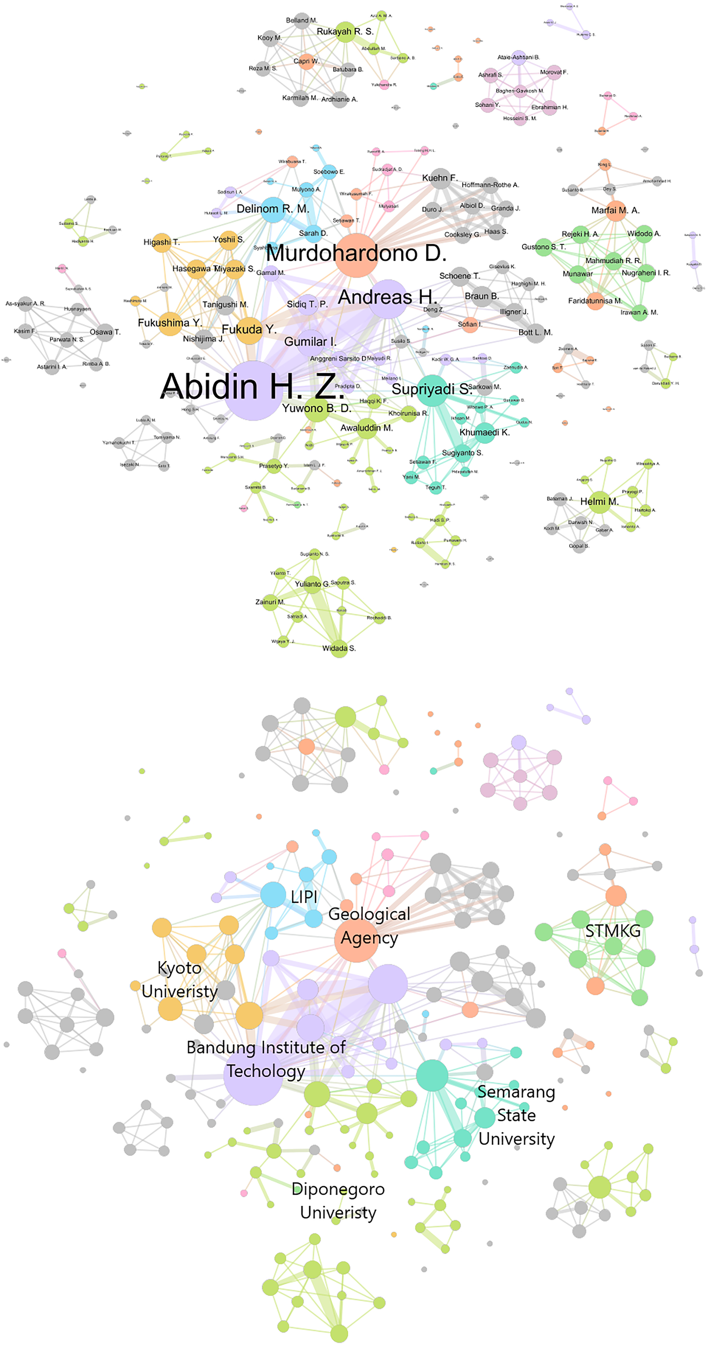
Co-authorship network of reviewed literature according to the affiliation of the authors. Each node is one author and each connection indicates that a group of authors published a text together.
Footnotes
Acknowledgments
The authors wish to thank our interviewees for their time and insights and Idham Effendi, Dwi Sarah, Irwan Gumilar, and Brian Bramanto for their generous comments on the draft.
Declaration of conflicting interests
The author(s) declared no potential conflicts of interest with respect to the research, authorship, and/or publication of this article.
Funding
The author(s) disclosed receipt of the following financial support for the research, authorship, and/or publication of this article: This project has received funding from the European Union’s Horizon 2020 research and innovation programme under grant agreement No. 861509 – NEWAVE.