
Abstract
Urban form is a key concern for sustainable urban development and climate change adaptation. Therefore, it has become a focus for policymakers and planners in the past decades. While many national governments implement land policies to pursue specific objectives, the actual outcomes in built urban form often remain scarcely evaluated, thus challenging the effectiveness and legitimacy of these policies in pursuit of urban sustainability objectives. In this contribution, we therefore evaluate anticipated outcomes of land policies by quantifying the emerging built urban form under these policies through a covariational approach. The French-German border-region serves as a study area due to its economic and demographic homogeneity, while fundamentally different land policies are pursued. A fine-grained geospatial data model representing the evolution of urban form is set up containing harmonised building, parcel and street network data. Based on this, building types, development blocks, ages and relative location through accessibility are delineated. The model is used to trace anticipated outcomes of key policy changes in the emerging urban form of the two countries. This assessment shows significant variance in measurable outcomes of specific land policies of the two countries, in time and by policy that can be linked to different initiatives of implementing policies in Germany and France, prompting a stronger debate of how land policies generate effects.
Introduction
Addressing built urban form, that is the physical configuration of buildings, blocks and streets (Anderson et al., 1996; Oliveira, 2016), has become key for policies to move towards sustainable development of cities and regions (Marcus, 2025). Urban form not only translates to biodiversity loss through land-take rates (Louwagie et al., 2017), induced carbon emissions through car-dependency and energy demands (Muñiz and Rojas, 2019), but also to increased vulnerabilities towards the effects of climate change (Kang et al., 2024; Stone et al., 2010). Moreover, it has become an increasingly political topic due to mounting pressures to provide housing (Monroy et al., 2020). Consequently, policymakers in many countries have been introducing land policies in the past decades addressing what land is used for, i.e. its allocation, and who is given responsibility and access, i.e. its distribution (Hartmann et al., 2025) to achieve characteristics like higher urban densities or a shifting away from single-family houses (SFH). The evaluation of such policies, that means whether they lead to outcomes in built urban form or not, is key to ensure their effectiveness and legitimacy (Needham and Hartmann, 2016).
In contrast to this need, there exist various scientific insights of land policy outcomes in built urban form which range from quantitative to qualitative, single to multiple case research designs. While some studies conclude general lack of effectiveness of land policies in achieving their objectives (Digafe et al., 2023; e.g. Koroso, 2023), other studies draw positive outcomes in built urban form (e.g. Zhao, 2011). Very often such differences in findings are discussed as a matter of context (see esp. Kim, 2023: 184f). However, these approaches typically rely on analyses only within an affected area of specific land policies without comparing it to development in other settings. By contrast, in comparative approaches, most studies rely on qualitative methods to assess land policy outcomes in urban form; Tennekes et al. (2015) compare the morphology of residential development in three European countries and link it to institutional differences in the land policy systems. Similarly, Buitelaar and Leinfelder (2020) qualitatively compare general land-take patterns in Flanders, Belgium and neighbouring Netherlands and explain the differences in relation to the specific land policy regulations. At a more granular, quantitative approach, Jehling and Hecht (2022) find more homogenous urban form in Germany than in France that they link to differences in land policy. However, they point out the need to better quantify outcomes of specific policies in the built urban form. Likewise, Götze and Jehling (2023) call for more refined evaluation of legal and planning conditions to explain differences in urban form patterns after comparing the Dutch and Swiss cases. Similar to this approach, Kim (2023) traces the effects of urban containment policies in the U.S. and assesses their effectiveness in contrast to other causes like demographics or pre-existing density levels. They stress the importance to consider effects of such contextual factors when comparing land policy outcomes. Finally, Grădinaru et al. (2017) point out the gap of evaluating land policy outcomes in the actual emerging urban form. Based on these various insights, a comprehensive approach for evaluating land policies and the relationship with built urban form is needed.
Therefore, this contribution aims at tracing anticipated outcomes of land policies by exploring whether they materialise in built urban form. Consequently, we ask the following questions: what outcomes of national land policies can be anticipated in urban from? Can these outcomes be traced in emerging urban form? For this, a covariational, comparative approach of land policy outcomes in emerging urban form is pursued and applied to a case study setting (Blatter and Haverland, 2014). Here, the French-German border-region serves with an empirical and methodological interest, as the high level of interconnectedness, homogenous demographic and economic development of the past years lead to similarity (Peyrony et al., 2022), while implemented land policies and planning cultures show strong differences (De Vries, 2015). Conceptually, this allows to delimitate land policy effects from other effects on built urban form derived from demographic and economic development (Teller, 2021).
For the operationalisation, we present an approach that assesses plausible outcomes of land policies and evaluates them in emerging urban form. We first conceptualise anticipated outcomes of land policies through an assessment of their discourse. Second, a cross-border geospatial data model of urban form is set up for the study area. To make general features of urban form comparable throughout the region (Marcus, 2025), the scale of development block is selected, that is grouping of individual buildings and parcels in proximity representing an urban development project (Kleiner et al., 2025). The fine-grained model facilitates a comparison of land policy outcomes by quantifying characteristics of urban form at several time-steps within the two national contexts.
Conceptualising outcomes of land policies
An understanding of land policy
Land policy can be defined as the actions that a public entity, for example a national government, pursues to obtain a political objective with an allocative and distributive focus on land (Hartmann et al., 2025; Puustinen et al., 2022). This means both the where and what for land is used (allocative) and the who or by whom (distributive). Further, land policy can be split into strategic and operational levels (Hartmann et al., 2025), that means the political objective-oriented land use and tenure (strategic), as well as the management and order-oriented land-use planning (operational). Universally, land policies focus on the tension between private property rights of land owners and the societal interests towards land (Davy, 2012a; Le Bivic et al., 2025; Puustinen et al., 2022). Land policy addresses the balancing between these two interests, defining how land is used and managed (Davy, 2012b: 31; Walters et al., 2011: 9). In this contribution, we thus focus on highly formalised strategic land policies at the national level that have found their way into applicable legislation.
Operationalising urban form
Urban form can be broadly defined as the physical characteristics of elements like streets, blocks, buildings and plots (Oliveira, 2016), as well as their configuration and relation to each other (Anderson et al., 1996). Živković further specifies urban form as the ‘housing type, street types, and their spatial arrangement’ (Živković, 2019: 1). Plots, i.e. the land underneath buildings, are stressed as important elements of urban form as they perform as ‘the spaces in which buildings evolve’ (Marcus, 2025: 146). Their relative location within city-regions, that is polycentric urban settlements (Jehling et al., 2021; Xiao et al., 2016), is further emphasised and is frequently discussed through accessibility (Marcus, 2025), i.e. whether elements are in more central, highly accessible, or more rural, less accessible areas. This means, urban form refers on one hand to the physical configuration of human settlement that can be morphologically assessed and measured – for example, through the size, shape, area, height of individual buildings and their distance to one another. On the other hand, it also refers to the semantic significance that can be interpreted through its morphological characteristics – for example, building types (like residential or commercial), or accessibility as their relative location within space.
Conceptualising the relationship between land policy and urban form
Through land policies, national governments pursue specific outcomes in urban form to achieve their politically set objectives. In the discourse of the political cycle of a land policy, the evaluation of their effects after they have been implemented is an important assessment for effectiveness and legitimacy, but also to reflect on the specific objectives of the policy (Needham and Hartmann, 2016; Smoke, 1994). Knoepfel et al. (2011: 247) differentiate three concepts of public policy effects: their impacts, outputs and outcomes. An example could be a land policy that aims at providing more social housing within tense housing markets; the term impact describes the result it has on the behaviour of actors, i.e. whether they apply the policy. Output describes the rate of implementation, i.e. how often it is used. And last, the term outcome describes the effect it has on the regulated subject itself, i.e. the share of produced social housing. Outcomes are thus not synonymous to objectives of land policies, but rather consequences of how land policies are set to pursue their objectives. Per their political nature, land policies are critically discussed and this discourse can thus be used to identify their anticipated outcomes.
This understanding of outcomes of land policies in urban form is based on an understanding of a causal relationship between the two. Blatter and Haverland (2014: 42) suggest covariational approaches within different contexts for drawing causal inference in policy research. The existing approaches (Buitelaar and Leinfelder, 2020; Götze and Jehling, 2023; Kim, 2023; Tennekes et al., 2015) strongly suggest that a comparative approach between cases yields promising insights in tracing outcomes of land policies. The two selected countries represent two cases with different policy settings resulting in differences in urban form. Consequently, a covariational approach of land policy (independent variable) and urban form (dependent variable) is pursued. This allows to draw causal inferences, when both variables covariate while other influences are considered as control variables (Blatter and Haverland, 2014: 55), that are expected to remain constant due to the homogenous context of the two cases. For this study, we consider land policies (cause) to be implemented to achieve a certain outcome in urban form (effect); thus, an unknown effect of a known cause is investigated (Rohlfing, 2012: 40). In this logic, land policies have a causal effect on emerging urban form through the actors applying them on site (Götze et al., 2024). While land policies are directly binding after their legal implementation, their actual translation into built urban form is dependent on planning processes, building permitting and construction itself. Thus, policy outcomes take time to manifest themselves in the built urban form until an effect can potentially be quantified (Laurian et al., 2010).
Land policies and their anticipated outcomes in France and Germany
As in France and Germany, urban form has been gaining prominence in the political discourse on urban sustainability of the past decades (e.g. BMUB, 2007; United Nations Sustainable Development, 1992). The following paragraphs describe the main land policy changes of the past decades in the two countries and their main anticipated outcomes in built urban form (Figure 1). Timeline of implemented policies and their anticipated outcomes, French policies on top and German policies below.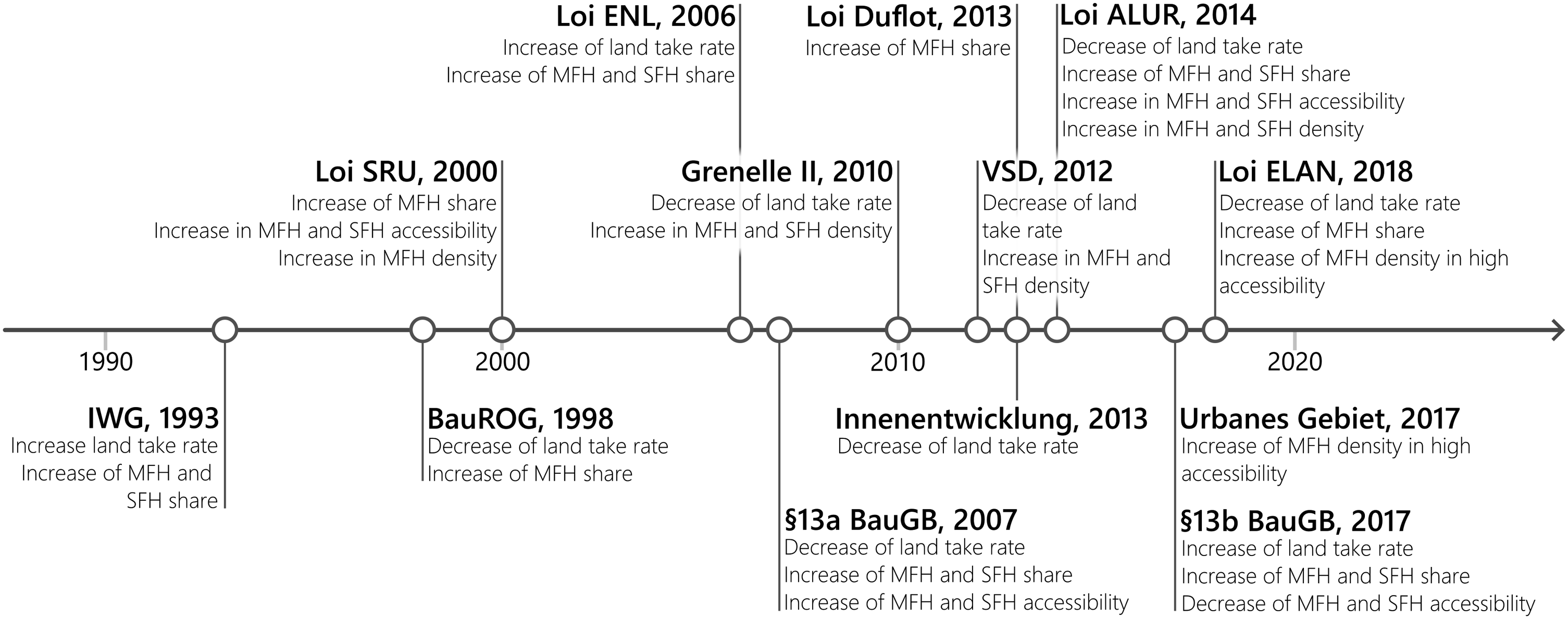
In France, the land policy focus is on social housing, as well as reducing land-take rates and relative location of desired development. Here, the Law on Solidarity and Urban Renewal (loi SRU) of 2000 is a key policy that obligates municipalities in populous agglomerations to achieve 20% social housing units and more dense residential areas (Levasseur, 2016). Non-achievement by municipalities would be punished by an annual penalty payment. As social housing is typically built in multi-family houses (MFHs), the policy is anticipated to lead to an increase of MFH, especially in accessible areas (Lévy-Vroelant et al., 2014; Maaoui, 2023). The efforts of the loi SRU were reinforced through the 2006 National Housing Commitment Act (loi ENL) aiming to accelerate provisioning of public residential land (Vorms et al., 2006). Thus, another increase in residential housing and land-take rate can be anticipated. The Grenelle II law of 2010 and the introduction of an optional municipal land value tax (VSD) in 2012 aimed at limiting land-take and producing higher density. The former, by giving municipalities the right to surpass density limits in local land-use planning for collective buildings (Denizeau, 2011). The later, by giving municipalities the option to implement a tax on low-density developments (Avner et al., 2014). The anticipated outcomes of these land policies are thus more dense residential development and lower land-take rates (Avner et al., 2013; Chauvin and Jégouzo, 2011). The public land mobilisation act (loi Duflot) of 2013 further raised the municipal social housing quota introduced through the loi SRU to 25%. Thus, another increase of MFH is anticipated as an outcome (Clément-Wilz, 2013). The law for access to housing and renewed urban planning (loi ALUR) of 2014 is again focused on providing more housing units and limiting land-take by lifting density limits and obliging municipalities to cooperate in joined land-use plans at the inter-municipal level (L’Herminier and Perrineau, 2014). Thus, an increase of more dense residential development and a decrease of land-take can be anticipated (Maleas, 2018). Finally, the housing, planning and digital technology law (loi ELAN) of 2018 reshaped the social housing sector and introduced public-private partnerships for bigger urban projects by mainstreaming planning procedures. It is anticipated to reduce land-take and produce more dense MFHs (Chambord, 2019).
In Germany, the land policy focus has also been strong on housing supply and limiting land-take. The investment-facilitation and residential-land act (IWG) of 1993 aimed to provide more land for residential development by giving municipal planning authorities key instruments for public-private cooperation. It is related to a higher land-take and an increase of residential building types (Sander, 1996). Besides a general reworking of the building code, the building and spatial planning act (BauROG) of 1998 aimed at limiting land-take by prioritising brownfield development, strengthening municipal pre-emption rights (Peine, 1998) and a stronger focus on MFH development (Runkel, 1999). Therefore, lower land-take and an increase of MFH share can be anticipated. Following regulatory amendments of the early 2000s, the introduction of an accelerated procedure for municipalities for brownfield re-development (§13a BauGB) of 2007 is anticipated to reduce land-take and increase residential building rates in accessible locations by reducing municipal participation- and environmental-requirements for brownfield development (Krautzberger, 2007). The 2013 inner-urban development law (Innenentwicklungsgesetz) promotes urban densification. By increasing complexity of urban extension projects for municipalities, it is anticipated to reduce land-take (Hagebölling, 2013). In contrast to this trend, the introduced accelerated procedure was expanded to small urban extension projects (§13b BauGB) in 2017 to provide more housing units (Krautzberger, 2018), thereby encouraging land-take again. In turn, an increase in the share of residential building types and land-take, especially in less accessible areas, is anticipated (Jehling et al., 2019). With the same legislative act, a new urban type (Urbanes Gebiet) was introduced that municipalities can implement in their local land-use planning. Allowing for mixed-use and higher urban density, this building type is directed at inner-urban development. It is thus anticipated to produce higher-density MFH especially in accessible locations (Sušnik, 2021).
Method and data
To compare the urban form emerging in the respective policy settings, the French and German side of the border-region are used to define the study area. For the delimitation, the two functional city-regions of Strasbourg (France) and Karlsruhe (Germany) are determined using 40-min isochrones around central points in the two cities. Municipalities that are at least 20% covered by the isochrones are selected and enclaved municipalities below 20% coverage are added. The study area is split into two case-study areas by the national border (see Table S02 and Map S05_01).
National data sources on building, parcel and street network data are homogenised as the basis of the analysis (see S01 for full data material). Further, assessments of building types, ages and their relative location through accessibility are analysed. The logical combination of these approaches forms a cross-border geospatial model that allows for comparison of emerging urban form between the two countries, as well as in time (Figure 2). Results are interpreted following the periods after the policy introductions through visualisation of the geospatial model.
Building development block delineation
Buildings and parcels are grouped into development blocks, representing areas that likely have been developed together (Kleiner et al., 2025). First, using CORINE land-cover (EEA, 2020) and street network, river and building data, parcels are filtered out that are non-urban or predominantly covered by streets and rivers. Next, address information is assigned to built-up parcels to keep neighbouring parcels separate that have been developed through different access roads. Based on shared address information, parcels are then clustered into groups in proximity. Next, a Delaunay triangulation is performed among the individual groups. Parcels without address information covered by these triangulations are assigned their addresses. Last, the now grouped parcels with addresses and remaining built-up parcels without addresses are joined and buffered by 10 m. Neighbouring non-built-up parcels are assessed for their overlap and included if they are covered by at least 20% of the neighbouring parcel groups.
Building type classification
Building types for each building are determined using a random forest classification algorithm based on morphological characteristics of building polygons (Hecht et al., 2015; Jehling and Hecht, 2022). The buildings are classified into thirteen different categories covering France and Germany (see S03 for accuracy and variable importance). For this, a training dataset of 19.483 buildings is manually assigned based on aerial imagery. The ten categories are then grouped into MFH, SFH, Public and Industrial building types and the dominant building type is determined for each development block by highest built volume. The morphological features are further used to describe urban form at the block level. Here, specifically the built-up volume to development block area ratio serves as a density indicator (Chen et al., 2024; Hartmann et al., 2024).
Development age identification and validation
Using the Global Human Settlement Age dataset (GHS-AGE: Uhl et al., 2025), development age of the development blocks are determined. The 100 m-gridded layer provides dominant built-up age of the building stock globally. The maximum value from the grid weighted by the overlap percentage is assigned for each development block. Open-access historic aerial images are used to create a validation dataset containing 1236 validated development blocks equally distributed for each 5-year-step from 1990 through 2020. The validation dataset confirms a 71% overall accuracy across time-steps which is determined sufficient for this analysis (see S04 for tolerance matrix).
Relative location through accessibility
To compare urban form, the relative location within the city-regions is of importance. We thus calculate the relative location of development blocks in a combined way of accessibility by car and walkability (Ulrich et al., 2023). For this, population estimates (Carioli et al., 2023) are used to determine the amount of people accessible at points on the street network within the cross-border region. Closeness centrality for each point is calculated with a decreasing weighted population reachable by car and a 2 km radius for walking. These two centrality measures for both individual city-regions are z-transformed, combined as a mean value to represent the accessibility of a location, and assigned to each development block (Jain and Jehling, 2020; Jehling et al., 2018) (see S05 for visual representation). For development blocks that are part of both city-regions, the relevant higher accessibility measure is chosen to describe a block’s relative location within the cross-border area.
Results
Anticipated outcomes of land policies on built urban form
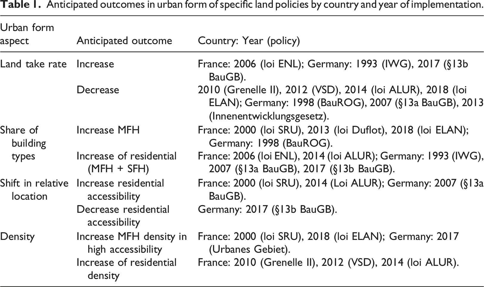
Anticipated outcomes in urban form of specific land policies by country and year of implementation.
Outcomes in urban form
Figure 3(a) shows the land-take in the French and German case-study areas and the introduction of the relevant national land policies addressing it (refer to Table S02 for contextual statistics). Here, the anticipated increase through loi ENL in France and IWG in Germany appears to manifest in the respective direct subsequent time-steps. However, the corresponding periods in the respective other country are defined by similar increases, e.g. the French land-take increases in 1996–2000 like the German land-take after IWG introduction, thus limiting the plausibility that these increases are outcomes of the specific land policies. In contrast, after the introduction of §13b BauGB the land-take rate in Germany increases stronger than in France, as anticipated. The time-steps after the introduction of Grenelle II and VSD, that were anticipated to decrease land-take rates in France, appear to be materialising. While both countries’ rates decrease, the French rate appears to be decreasing much stronger. Similarly, after the introduction of loi ALUR and loi ELAN anticipated to reduce land-take rates in France; even though both countries’ rates are increasing, the French rates are increasing weaker than the German equivalents. In Germany, anticipated to decrease land-take, BauROG appears to indeed lead to a more significant decrease than measurable in France. The anticipated outcomes of §13a BauGB and Innenentwicklungsgesetz, however, do not appear to materialise in Germany when compared to the French counterparts. Land-take change in context of land policies in French and German study areas, (a) by building footprints [ha] and (b) share of building volume [%] by types in 5-year steps.
To further assess anticipated land policy outcomes, Figure 3(b) focusses on the share of building types. In France, loi SRU and subsequent lois Duflot and ELAN were anticipated to lead to an increase in the share of MFH. While a small uptake in the share of MFH after the introduction of SRU is observable in France, the following years follow the trend of declining MFH shares in both countries. The same anticipated outcome of BauROG in Germany appears to not have materialised. Regarding the anticipated outcome of more residential buildings in general, i.e. SFH and MFH, the French loi ENL and loi ALUR appear to neither lead to a difference in share of residential building types. In Germany, IWG and §13a BauGB also do not produce the anticipated outcome of more residential buildings. In contrast, the anticipation of §13b BauGB to increase the share of residential buildings appears to be indirectly materialising, as residential building types decrease slightly less in Germany than in France.
Further, several land policies have focussed on built densities and location of outcomes in space. Consequently, Figure 4 shows (a) the relative location of SFH and MFH blocks weighted by block area and (b) the distribution of built density of the two types produced in different relative locations. Here, in Figure 4(a), the anticipation towards French lois SRU and ALUR to increase residential projects in more accessible locations cannot be traced in emerging urban form. In contrast, the German §13a BauGB appears to result in an increase of accessible residential building types that is not apparent in French counterparts, suggesting to be an outcome of this land policy. By comparison, the anticipated outcome of §13b BauGB of lower accessibility of residential buildings does not appear to materialise. Relative distribution of built urban form emerging in the context of land policies, by (a) frequency of block area by relative location through accessibility and (b) built density as built volume on block area [m3/m2] by SFH and MFH.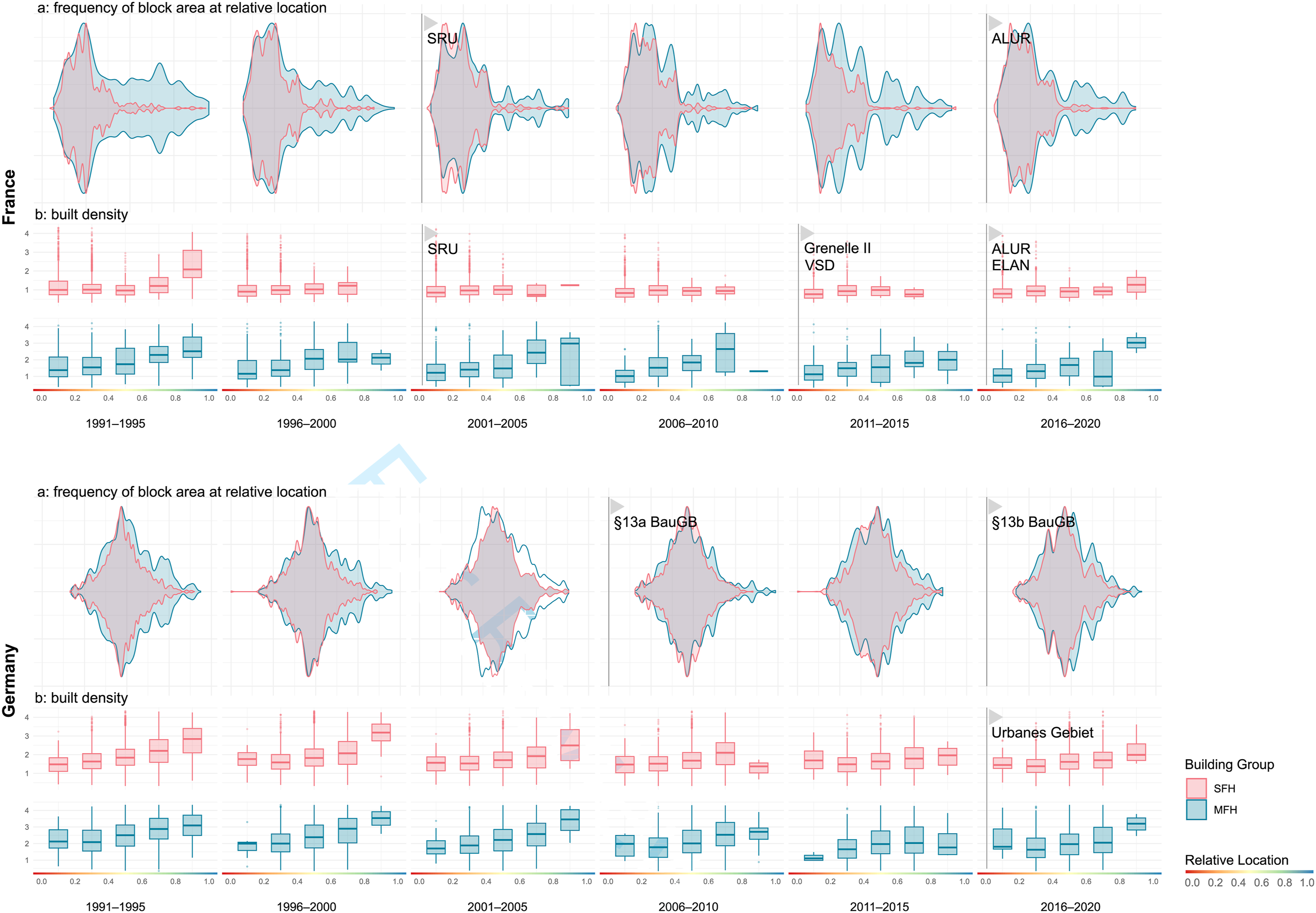
Further, Figure 4(b) shows the shift in built density by relative location. Here, the French lois SRU and ELAN both appear to have led to a higher density within very accessible MFH as anticipated, that are not visible in the German counterparts. The Urbanes Gebiet introduced in Germany discussed with the same anticipated outcome does not appear to take effect. Lastly, the anticipated outcome of Grenelle II, VSD and loi ALUR in France that residential densities would generally increase in all locations does not appear to materialise.
Discussion
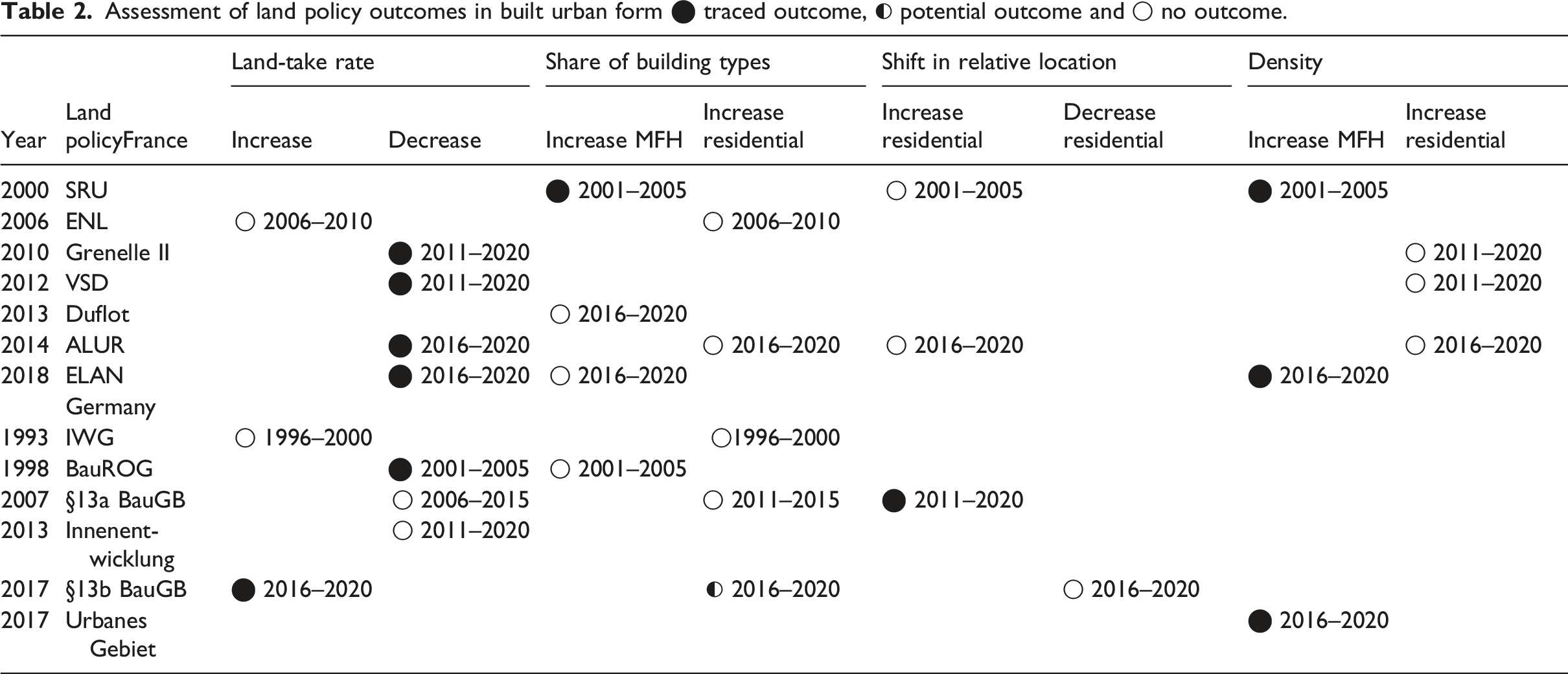
Assessment of land policy outcomes in built urban form ⬤ traced outcome, ◐ potential outcome and ◯ no outcome.
Tracing anticipated and conflicting outcomes of land policies
The social-housing focus in France is reflected in an anticipation of increased MFH (Lévy-Vroelant et al., 2014). While this focus leads to an outcome for some land policies, for example loi SRU, other land policies appear to remain ineffective in the analysis, like loi ENL. Similarly, a decrease of land-take rates can be traced following a number of French land policies, in Germany only the BauROG appears to have led to a decrease of land-take rate. Referring to the main research question, anticipated outcomes of land policies can thus partly be traced in built urban form. However, while individual anticipated outcomes can be traced, like an increase of share and density of MFH after the introduction of loi SRU, other anticipated outcomes of the same law, e.g. MFH in more accessible locations, cannot be traced. While some anticipated outcomes were traceable, for none of the identified land policies all anticipated outcomes were traceable. These findings in turn reflect the contradictory results on the effectiveness of land policies other studies have concluded (e.g. Digafe et al., 2023; Kim, 2023; Koroso, 2023). Here, the presented approach of relative location through accessibility allowed for a critical discussion of the potentials of a shift in urban development in urban, rural and suburban parts of a functional region, while avoiding a too technocratic understanding of land policy outcomes (Tennekes et al., 2015). This allowed for an evaluation of outcomes in different locations within the city-regions. By broadening the view on multiple aspects of land policy outcomes, the approach helps to enrich the discourse and allows for a more accentuated reflection on land policies. For the debate on sustainable urban development, the evaluation of land policy outcomes may profit from an evaluation of multiple overlaying and interfering outcomes of individual land policies in built urban form. That means that individual land policies may only have an outcome if other land policies or their outcomes are present. Likewise, the lag until they actually produce outcomes after their implementation needs to be further considered (Laurian et al., 2010). This helps to define the role of land policies towards more sustainable urban form (Marcus, 2025). In addition, however, the evaluation of anticipated outcomes also shows divergent directions of land policy throughout time and national contexts. Here, the German focus on reducing land-take through §13a BauGB in 2007 and Innenentwicklungsgesetz in 2013 is countered by a facilitation of urban extension projects through §13b BauGB in 2017. While a reduction of land-take cannot be seen after the introduction of the first two policies, the third appears to have led to an increase of land-take rate.
The causal relationship of land policy and urban form
In this contribution, the complex relationship between land policies and the small-scale emerging urban form on-site has been abstracted in a covariational approach (Blatter and Haverland, 2014). The results show the feasibility of linking anticipated outcomes from a policy discourse with changes traced in emerging urban form. While this covariational approach proofs to provide relevant insights, it remains short of describing causality between land policies and urban form (Rohlfing, 2012). As the approach allowed to limit homogenous effects in the two countries, strong external effects appear to have strong and plausible outcomes. For example, the nosedive of land-take in both countries could be explained through the global financial crisis of 2008. To further explore the effectiveness of land policy initiatives in translating anticipated outcomes into realities, a more in-depth assessment of the policies and how they operate is needed.
Further, an understanding of land policy as the strategic, normative actions of a national government in pursuit of an allocative and distributive objective in land (Puustinen et al., 2022) helped narrowing relevant land policies. However, the strong increase in land-take through industrial buildings suggests that strategic land policy goals at the national level are circumvented by economic drivers at the operational level by municipal planners (Hartmann et al., 2025; Le Bivic et al., 2025). Here, it could be hypothesised that individual land policies as specialised instruments might not cover the complex institutional configurations or needs on-site. Thus they are applied differently through municipal planning authorities, leading to unexpected applications and outcomes (Götze et al., 2024; Marcus, 2025). Land policies as formulated through national governments could thus be deconstructed as either appropriate technical solutions to political problems, as narrative tools to induce certain behaviour among municipal actors, or redundant regulations that are overshadowed by municipal, operational, planning decisions. Here, an assessment of planning actor’s motivations and conflicts in pursuing objectives set in land policies is needed. Further research could make use of this approach to provide insights into the practical implications of land policies and their interactions. This implies to include the regional planning levels, like Schéma-de-Coherence-Territoriale (SCoT) in France and Regionalpläne in the German Länder.
Reflections on the geospatial approach
A fine-grained, large-scale geospatial model was set up for the French-German study area based on harmonised national geo-data, responding to the need to assess land policy outcomes quantitatively (Buitelaar and Leinfelder, 2020). The interpretation of emerging urban form shows that the approach successfully integrated heterogenous national datasets for a comparative approach. The approximation to block age determination using the GHS-AGE (Uhl et al., 2025) (see S04; S05) additionally enriches the existing discourse of land policy effects and allows more precise assessment of built urban form in the context of land policies (compare to e.g. Jehling and Hecht, 2022). The approach further closes the gap in describing built urban form as outcomes of land policies. However, because of the unavailability of large-scale historic building data, the difficulty to address demolition-and-rebuilding as well as small-scale infill-densification persists a methodological challenge that needs to be addressed in future research. The integration of relative, city-regional location through accessibility provided relevant nuance to differentiate the analysis of urban form and enhance the interpretation of outcomes.
Splitting the study area into two case-study areas for a comparative covariational approach allowed to limit other effects on urban form aside land policies. The approach allowed an interpretative evaluation of outcomes. It showed that some anticipated outcomes of specific land policies, like focus on housing type and reduction of land-take, were able to be traced in emerging urban form, while other outcomes were not. Thus, it helped to close the gap in understanding effects of land policies in urban form (Grădinaru et al., 2017) and prompting a stronger evaluation of the relationship between land policy and urban form.
Conclusion
In this contribution, anticipated land policy outcomes in emerging urban form were traced in a covariational comparative case-study approach using a geospatial model in the French-German border-region. The results set the basis for further analysis of the land policies as well as actors’ motivations in applying them, and for broader statistical evidence on contextual factors and temporal changes before and after the implementation of land policies. Also, a detailed analysis of the specific institutional configurations of land policies across planning levels appears as a promising pathway to better understand policy application through actors. The approach has helped to reflect on the evolution of urban form as an effect of land policies and the causal relationship between the two. The operationalisation of effects as outcomes and the conceptualisation of anticipated outcomes of land policies in built urban form help to structure the discourse on sustainable urban form. The results on the effectiveness of different national land policies raises questions on how specific outcomes of land policies appear to materialise while others do not. With this, the insights provide reflection for policymakers to allocate land policies more effectively to achieve land policy outcomes in urban form.
Supplemental material
Supplemental material - Evaluating land policy outcomes in emerging built urban form. A covariational geospatial approach
Supplemental material for Evaluating land policy outcomes in emerging built urban form. A covariational geospatial approach by Caspar Kleiner and Mathias Jehling in Environment and Planning B: Urban Analytics and City Science
Footnotes
Acknowledgements
We would like to thank Lucie Kluwe, our student assistant, for her outstanding support with the geospatial model. We would also like to thank Prof. Dr. Thomas Hartmann for his supervisory role and the two anonymous reviewers for their extensive and productive feedback on our work. Further, we are grateful for the critical feedback on our approaches by our colleagues at the International Seminar on Urban Form (ISUF) and the International Academic Association on Planning Law and Property Rights (PLPR).
Funding
The authors disclosed receipt of the following financial support for the research, authorship, and/or publication of this article: This contribution is made possible through the project ‘Form Follows Policy’ funded through the German Research Foundation (DFG) under the project number 512639122.
Declaration of conflicting interests
The authors declared no potential conflicts of interest with respect to the research, authorship, and/or publication of this article.
Data Availability Statement
Supplemental material
Supplemental material for this article is available online.
Author biographies
References
Supplementary Material
Please find the following supplemental material available below.
For Open Access articles published under a Creative Commons License, all supplemental material carries the same license as the article it is associated with.
For non-Open Access articles published, all supplemental material carries a non-exclusive license, and permission requests for re-use of supplemental material or any part of supplemental material shall be sent directly to the copyright owner as specified in the copyright notice associated with the article.