
Abstract
Traditional urban planning frequently overlooks Children’s Independent Mobility (CIM) – the developmental stage where children begin to navigate their environment without adult supervision. Current educational methods often fail to bridge the ‘knowledge-behaviour gap’ which represents the disconnect between knowing traffic safety rules and applying them in real-world situations. To address this, this study presents a site-specific geogame using a Minecraft digital twin of two school neighbourhoods in Utrecht, Netherlands. Both the game environment and the engagement process were co-designed with traffic-focused local authorities to ensure relevance to real issues. Primary school children navigated the virtual environment and responded to embedded spatial questionnaires regarding traffic safety rules around their schools. The results demonstrate that this approach shifts children’s roles from passive learners to active ‘citizen-experts’. Analysis of in-game movement and chat logs revealed specific spatial insights actionable for planners, including the identification of perceived danger zones and preferred shortcuts. The study concludes that geogames may offer a scalable method to capture children’s situated spatial knowledge and effectively integrate their perspectives into the urban design process.
Introduction
The imperative to involve youth in public decision-making, expressed in Article 12 of the Convention on the Rights of the Child (UN, 2023), has become a key policy consideration for creating inclusive cities. A critical discipline where this principle applies is urban planning, particularly concerning Children’s Independent Mobility (CIM). CIM refers to the stage of children’s development where they begin to move through the environment, commonly associated with the activity of walking or cycling from home to school or for leisure, independently of an adult (Lehtonen et al., 2017). Research on CIM has emerged as a critical area of inquiry due to its implications for child development, physical activity, and urban sustainability. Since the seminal studies in the 1970s documenting children’s freedom to travelling unaccompanied, longitudinal and cross-national research has revealed a marked decline in CIM across diverse contexts, including England, Germany, Australia, the US, and Finland (Malone, 2011; Marzi et al., 2018; Shaw et al., 2015). This decline is significant given that CIM supports cognitive, social, and motor development and contributes to healthier lifestyles (Hillman, 1994; Marzi et al., 2018). For instance, in Finland, independent school travel dropped from 82% to 50% over two decades, while in Australia, independent school travel halved between 1991 and 2012 (Marzi et al., 2018). In the US, active travel to school plummeted from 48% in 1969 to 13% in 2009 (McDonald et al., 2011). The social and environmental consequences of reduced CIM have prompted calls for child-friendly urban planning and policy interventions (Malone and Rudner, 2015). CIM is a key area of study concerning children’s physical, social, and cognitive development, yet urban planning processes often overlook this specific need and perspective. This oversight creates a significant gap between policy ambitions and the lived reality of children’s safety and well-being in urban spaces.
Participatory approaches improve planning outcomes and empower children but are not widely institutionalized, limiting their broader impact (Ataol et al., 2019; Cele, 2015; Paracha et al., 2019). Children’s direct involvement in transport planning remains limited and often confined to small-scale projects, reducing the inclusivity and relevance of urban interventions. This calls for urban planners and policymakers to prioritize the explicit integration of child-friendly objectives into land-use and transport planning documents to ensure that children’s mobility and safety needs are systematically addressed and embedded into actionable guidelines, beyond vague vision statements (Gilbert and O’Brien, 2005).
One of the challenges for including children’s perspective into planning is methodological. Currently there are limited effective tools being applied for capturing children’s uniquely situated knowledge of their neighbourhoods. Traditional participatory methods often fail to move beyond tokenism, struggling to generate the kind of authentic, spatially-aware insights needed to inform traffic planning. To create safer and more child-friendly environments, planners need new ways to understand how children perceive traffic rules, identify risks, and navigate their daily journeys.
Geogames, considered games that leverage spatial mechanics and authentic geographic data (Ahlqvist and Schlieder, 2018; Poplin et al., 2023), offer a powerful and innovative solution to this challenge. By embedding playful participation within virtual representations of real-world places, geogames can elicit children’s perspectives in a contextually relevant and engaging manner. This approach moves beyond abstract questions, allowing children to interact with and respond to specific locations, thereby generating richer, spatially explicit data that can be directly translatable into actionable evidence for planning.
Among various platforms, Minecraft has emerged as a promising environment for this purpose. It provides a flexible, block-based world that allows for the creation of recognisable urban spaces, empowering children to explore, modify, and articulate their perspectives within a digital environment they are often already familiar with (de Sena and Stachoň, 2023). As part of a European project that catalyses change in mobility practices by fostering citizen participation, this study presents the co-design and implementation of a spatial questionnaire within Minecraft, aimed at engaging children in discussions about traffic safety around their schools in the Netherlands. This paper investigates how a geogame can bridge the gap between children’s lived experiences and urban planning practices. To guide this inquiry, the study addresses the following research questions: How can a geogame, using a platform like Minecraft, be co-designed with local decision-makers to elicit and capture children's situated knowledge of their local traffic environment?
What specific types of child-centred spatial insights can be generated through this geogame-based approach, and what are their practical implications and limitations for traffic planning interventions?
To answer these questions, this study first provides a focused literature review of CIM policy and design literature. It then details the co-design process, deployment, and data analysis, situating the pilot study in relation to the persistent gaps in CIM studies.
Background and literature review
Research on urban planning guidelines and policy effectiveness in child-centred transportation and traffic planning has emerged as a critical area of inquiry due to the increasing recognition of children’s rights to safe, accessible, and independent mobility in urban environments (Gilbert and O’Brien, 2005). Over recent decades, the field has evolved from adult-centric urban design toward more inclusive approaches that consider children’s unique needs and vulnerabilities (Ataol et al., 2019; Woolcock et al., 2010). This shift is underscored by global initiatives such as the United Nations’ Child-Friendly Cities movement and sustainable development goals that emphasise inclusive urban spaces (Sapsağlam and Eryılmaz, 2024). The significance of this research is further highlighted by alarming statistics on child pedestrian injuries and fatalities worldwide, with traffic accidents remaining a leading cause of death among children (Bhalla and Gleason, 2020; Welle et al., 2016). Urbanisation trends and car-centric policies have exacerbated barriers to children’s independent mobility, affecting their physical activity, social development, and well-being (Riazi et al., 2019; Sonneveld et al., 2024).
Despite increasing awareness, a persistent knowledge gap exists regarding the translation of child-centred transportation policies into effective urban planning practices (Awada, 2024). While some cities have adopted child-friendly visions, implementation often lacks clarity, measurable indicators, and integration across planning documents (Gilbert and O’Brien, 2005). Dilemmas and differences of opinion arise between advocates emphasising participatory approaches involving children and families (Ataol et al., 2019; Cele, 2015) and critics highlighting insufficient policy enforcement and adult-centric biases (Awada, 2024). The consequences of this gap include limited independence for children, increased reliance on motorised transport, and diminished opportunities for active travel, which contribute to public health and equity challenges (Curtis et al., 2015; Riazi et al., 2019).
The use of games and simulations in road safety education for children has emerged as a significant area of research, offering engaging alternatives to traditional pedagogical methods. Studies suggest that digital games can target the foundational cognitive skills underpinning safe road behaviour. For instance, research has demonstrated a direct link between children’s attentional skills, as measured in a computer game, and their awareness of traffic in real-world crossing scenarios (Dunbar et al., 2001). Beyond cognitive skills, games have also been employed as diagnostic tools to identify children with a higher propensity for risk-taking. One study found that a child’s behaviour in a simple laboratory game was predictive of their decision-making in actual traffic, suggesting such tools could help identify high-risk children for targeted interventions (Hoffrage et al., 2003). Researchers have focused on developing simulation games that provide a safe, ‘learning-by-doing’ environment where children can practise and receive immediate feedback, leveraging multimedia and interactive scenarios to foster knowledge acquisition (Ariffin et al., 2010; Proaño et al., 2019). More recent explorations into Virtual Reality (VR) technology indicate a high level of appeal and engagement among school children, highlighting VR as a potentially powerful medium for teaching safe cycling and hazard perception (Vuorio, 2024).
Despite the promise of game-based interventions, a substantial body of evidence complicates the narrative by highlighting the persistent gap between knowledge and behaviour. A ‘knowledge-behaviour’ gap arises when an increase in knowledge, achieved through education or training, does not translate into a corresponding improvement in practical, real-world actions or behaviour. A critical study by Zeedyk et al. (2001) conclusively showed that classroom-based interventions, including a board game, successfully increased children’s knowledge of road safety, but this knowledge did not translate into safer behaviour during observed road crossings. This mismatch between knowledge and behaviour suggests that simply knowing the rules is not enough to ensure safety. This challenge is also evident in studies of more advanced learning games. For example, a computer game designed to train situational awareness in child bicyclists improved reaction times but failed to significantly enhance their sensitivity to detecting hazards, especially covert ones like road users hidden by street corner occlusions, such as behind parked cars or a house (Lehtonen et al., 2017). Even highly engaging VR environments, while popular with children, come with the caveat that enjoyment and learning within the simulation do not guarantee a reduction in real-world injuries (Vuorio, 2024). While games are a valuable tool for engagement and skill development, their ultimate effectiveness depends on their ability to bridge the critical gap between simulated learning and applied, real-world safe conduct.
The potential of geogames for CIM studies
Drawing upon the concept of serious games and playful public participation (Poplin, 2012), the development of spatial questionnaires within virtual environments offers a novel approach to data acquisition in urban planning and related fields. By anchoring questions to a location and including game elements and mechanisms, the players’ interaction with the represented environment can be assessed as a geogame. Specifically, researchers and practitioners are increasingly leveraging game-based platforms designed to simulate real-world scenarios, such as urban development or disaster preparedness (Tomaszewski and Schwartz, 2017). These purpose-built games often integrate authentic geographic data (Poplin et al., 2023), employ narrative structures to contextualise problems, and frame player interactions around specific questions or tasks pertinent to the planning domain.
The spatial mechanics and voxel-based structure of games like Minecraft provide a foundation for precise spatial referencing. As highlighted by de Sena and Stachoň (2023), Minecraft’s geogaming mechanics underscore its potential as a platform to support learning activities within geography and cartography. This inherent geographical context offers a unique opportunity to harness a familiar virtual space, enabling young people to articulate their perspectives on complex topics, such as traffic regulations, through spatial expression. The integration of questionnaires within such game environments can be achieved seamlessly by embedding them as ‘game elements’ to mitigate the disruptive nature of traditional pop-up surveys or external links (Frommel et al., 2015). To enhance engagement and participation, various gamification strategies, such as the provision of in-game rewards for completing questionnaires, can be effectively employed (Steinmaurer et al., 2021). This approach aligns with the principles of playful public participation, fostering a more engaging and contextually relevant method for eliciting spatial perceptions and preferences.
The research focus of this study emerges from an identified methodological gap in the literature around the lack of effective participatory tools capable of capturing children’s context-specific spatial knowledge and, the potential of geogames as a bridge from representation of spatial-related issues to tangible behaviour change. The literature reveals that while the importance of CIM is widely acknowledged in academic literature (Prezza and Pacilli, 2007; Fyhri and Hjorthol, 2009; Mitra, 2012), the methods used to engage children often fall short, evidencing a persistent ‘knowledge-behaviour gap’ in traditional traffic safety education (Thomson et al., 1996; van Schagen and Rothengatter, 1997). This gap suggests that even when children can recite safety rules, this abstract knowledge does not consistently translate to their real-world actions. This occurs because conventional methods are ill-equipped to capture children’s situated understanding of their environment, such as how they actually perceive and navigate specific intersections, shortcuts, or danger zones on their terms. This failure points to a critical need for new tools that can move beyond abstract knowledge and access the rich, context-specific spatial intelligence that children possess. To address the inability of conventional methods to capture children’s situated understanding, we propose a methodology that offers a site- and challenge-specific geogame experience. By co-designing the game with local authorities, the approach targets relevant CIM issues while providing a well-known virtual environment for children to navigate and test their safety knowledge.
Research methodology
This study employed a two-phase process to discuss the geogame concept through the lens of CIM (Figure 1). Phase 1 involved a focused literature review on CIM to identify theoretical gaps and practical challenges in child-centred transportation planning. Phase 2 involved the co-design and implementation of a Minecraft-based geogame to pilot a participatory methodology for children’s engagement in traffic planning. Research framework illustrating the two-phase approach. Phase 1 establishes the theoretical basis through a focused literature review. Phase 2 details the collaborative co-design workflow involving researchers and municipality officers, highlighting the iterative nature of the pilot workshops and the specific game mechanics (parkour and spatial questionnaires) used to collect data.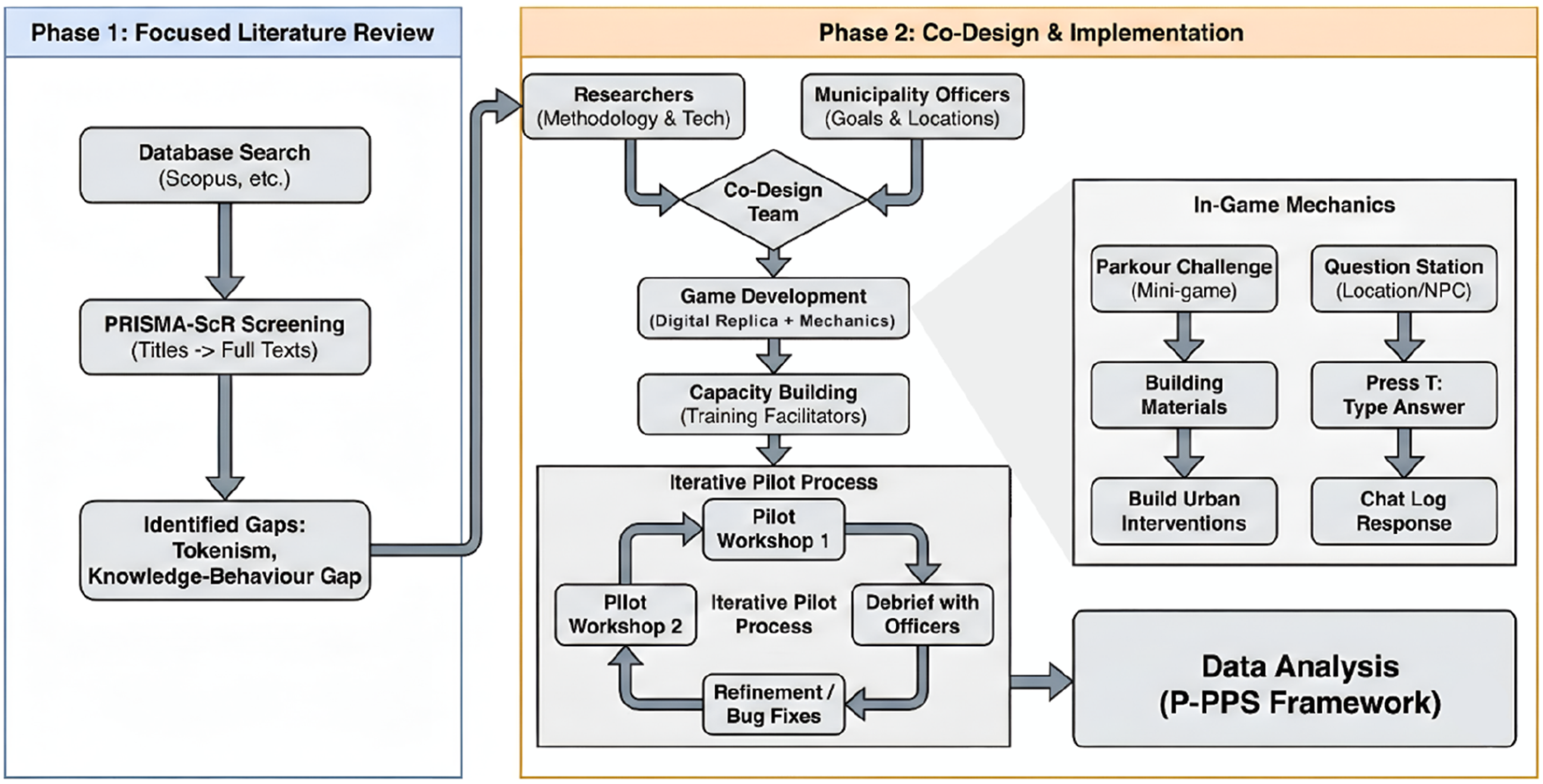
Focused literature review
The focused literature review followed Arksey and O'Malley (2007) and Levac et al. (2010) frameworks and the PRISMA-ScR checklist. It was employed to map research on urban planning guidelines and the effectiveness of child-centred transportation policies. The search was conducted across Scopus, Web of Science, PubMed, ScienceDirect, Google Scholar, and policy repositories using keywords related to CIM (e.g. child-centred transport, urban planning guidelines, independent mobility, and traffic safety). Additional sources were identified through query transformation, backward and forward citation chaining, and relevance ranking. Studies published in English between 1990 and 2025 were considered, with inclusion limited to literature addressing children’s mobility, safety, or participatory planning within urban transport contexts. Screening followed a two-stage process (titles/abstracts, then full texts) by two independent reviewers. The initial search yielded 108 articles, of which 32 were included in the final review after screening. Findings revealed that while child-friendly mobility policies exist, their implementation is hindered by adult-centric biases, tokenistic participation, and a lack of tools to translate children’s spatial knowledge into actionable planning data.
Co-design and game mechanics
To address the gaps in participatory practice identified by the focused literature review (reliance on adult-centric biases, tokenistic youth involvement, and the absence of tools to capture geographically situated feedback), Phase 2 involved the co-design and implementation of a Minecraft-based geogame. Phase 1 revealed that children’s participation is often tokenistic and lacks context. To address this, we chose to create a digital twin of the children’s actual school area using OpenStreetMap data, ensuring the activity was place-based and contextually relevant and anchoring the activity in a familiar environment. For that, we co-designed a Minecraft-based spatial questionnaire to pilot the geogame-based CIM approach. The development of the Minecraft spatial questionnaire followed the principles of iterative game-design as presented by Fullerton (2014).
A co-design approach involving two academic researchers and three officers from the Municipality of Utrecht Traffic Department was employed. The responsibilities were divided to leverage distinct expertise: the researchers were responsible for proposing the methodological framework and the technical development of the Minecraft digital replica. Conversely, the officers acted as subject-matter experts, advising on the specific learning goals and identifying priority locations, such as dangerous intersections, where the spatial questions should be situated. Prior to the pilot, the researchers provided a capacity-building training session for the officers. This training prepared the officers to run the pilot workshops effectively, ensuring they could facilitate the sessions with remote technical support from the research team. The co-designing process involved six stages: questionnaire development; integrating OpenStreetMap data into Minecraft; developing a spatial data collection framework; conducting capacity building workshops; running pilot workshops in two schools in Utrecht; and debriefing with facilitators.
The geogame was designed with two distinct layers of interaction: a spatial questionnaire for data collection and playful challenges to maintain engagement. The spatial questionnaire was designed focussing on key traffic rules and safety concerns around the participating schools. The questions (Q) were designed to be age-appropriate and engaging for the target audience. In the game, these appeared as panels at specific locations (intersections, sidewalks) featuring a picture of the traffic scenario (e.g. ‘Are you allowed to cycle here?’, ‘Who goes first?’). An adjacent NPC (Non-Player Character) displayed text explaining how to answer, instructing players to ‘Press T’ and type their answer in the chat. To introduce playfulness and mitigate test fatigue, mini-games were added between questions. Players were prompted to build urban interventions (e.g. trash bins, speed signs) around the school. However, to collect materials for these builds, players had to overcome parkour challenges located on rooftops or custom structures, guided by visual cues from highlighted NPCs.
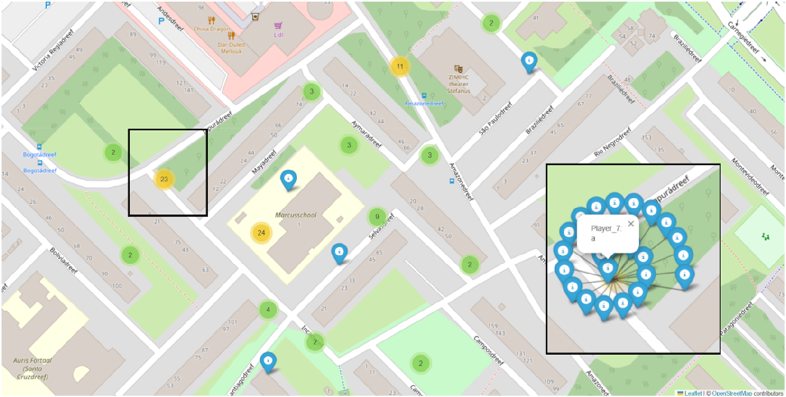
The framework used for collecting and analysing the spatial data generated during the activity in Minecraft is based on the Playful Participatory Planning System (P-PPS) framework, developed by de Sena et al. (2025). This included logging chat messages with their locations and tracking player movements within the game world.
Pilot implementation and procedure
The pilot workshops were conducted with two primary schools in Utrecht. Participants included 52 children aged 10–12, recruited from schools selected through an engagement process led by local authorities as part of the REALLOCATE project. To mitigate disparities in digital literacy, students worked in pairs sharing one computer. This pairing strategy intentionally matched experienced players with less experienced ones to encourage social interaction and peer-to-peer scaffolding.
The workshops had a total duration of 60 minutes, structured into three segments: a 10-min briefing and tutorial to familiarise children with the controls and objectives; 40 minutes of gameplay; and a 10-min debriefing and discussion. One facilitator was drawn from the group of traffic officers involved in the co-design, running the workshop supported by classroom teachers and remotely by one member of the research team. Their role included briefing participants, observing reactions, and recording feedback. The game was available in both English and Dutch to accommodate immigrant children.
Regarding the impact of gaming experience, observations revealed different play styles (e.g. explorers vs achievers) among the participants. These observations directly informed the iterative design process: following the first workshop, the facilitator met with researchers to discuss how these play styles impacted the activity flow. This feedback allowed the researchers to refine the game mechanics and fix bugs before the second workshop. Pairing players ensured that all groups could successfully reach the question stations and complete the tasks regardless of individual Minecraft proficiency. Our objective was not to test rule knowledge per se, but to elicit spatial perceptions and authentic behaviours, which we captured through chat logs and player movement tracking.
Results and discussion
Spatial questionnaire and in-game activity
The pilot study yielded quantitative and qualitative data through the P-PPS framework, combining chat logs, player movement tracking, and in-game construction activities. The in-game questions (Figure 2 and Figure S1) present specific traffic scenarios in relation to their context in the Minecraft environment. These questions were spatially located at key intersections identified by traffic officers during the co-design phase. Figure 3 demonstrates how the P-PPS framework displays the chat log as geolocated messages. Example of a question panel and NPC located at an intersection close to the school 1. Example of spatially located chat messages from the geogame, visualised as points on a map using real-world coordinates.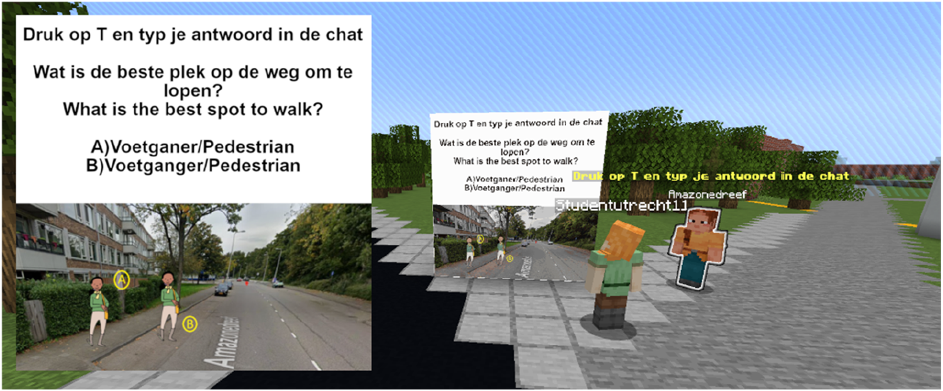
School 1: This school had a larger initial protected area. Limited building occurred due to time constraints, with players primarily focussing on exploration (Figure S2). Player movement data revealed that the majority of players focused their exploration and initial building attempts within the immediate vicinity of the school. However, one player ventured significantly further, travelling almost to the world limit barrier. This suggests varying levels of engagement with the assigned task and a tendency for some players to prioritise exploration over the intended activity. Additionally, the generated Minecraft world included deep water bodies, which hindered player movement and required later remediation. Q1 (Pedestrian/Cyclist Priority): Four players answered, with three correct answers (75%) and one incorrect answer (25%). Q2 (Cycling Permissions): Fifteen players answered, with 13 correct answers (87%) and two incorrect answers (13%). This question, being closer to the school, garnered more responses. Q3 (Cyclist Positioning relative to Bus): Six players answered, with all six answers being correct (100%).
School 2: Based on feedback from School 1, the protected zone around School 2 was reduced, facilitating quicker access to the creative zone and encouraging more building activity. This adjustment proved effective, resulting in more engagement with the building component of the geogame (Figure S3). Players collaboratively addressed the challenge of reaching the creative zone, as evidenced in the chat. The questions for School 2 were revised to focus more on pedestrian-related issues. Q1 (Pedestrian/Cyclist Priority): Twenty-one answers were recorded, with 17 correct answers (81%) and four incorrect answers (19%). Notably, some players changed their answers, both from incorrect to correct and vice versa, suggesting a process of reflection and potentially peer influence within the public chat. Q2 (Cycling Permissions): Six answers were recorded, all of which were correct (100%). Q3 (Pedestrian Walking Areas): Six answers were recorded, all of which were correct (100%).
A notable observation across both schools is the variance in the number of responses per question (e.g. in School 1, Q2 received 15 responses, while Q1 only 4). This variance is attributed to the game’s open-world design. Unlike linear surveys where participants are forced to answer sequentially, players had the freedom to explore the digital twin as they wished. Questions located closer to the ‘spawn point’ (the school entrance) naturally received higher foot traffic. The multiplayer nature of the game led to social clustering; players communicated verbally to guide each other, often bypassing certain areas to reach the ‘Creative Zone’, a designated area further from the school where building mechanics were unlocked for the urban intervention tasks.
Players at School 2 engaged more actively in building within the creative zone, constructing elements such as sidewalks, parking lots, and speed limit signs. This suggests that the reduced protected zone and the subsequent improvements to navigation and material collection were successful in promoting this aspect of the activity.
The creative zone in School 2 registered a number of interventions made by players. In general, players playfully interacted with the environment, placing and breaking blocks while exploring possibilities of Minecraft mechanics, such as portals, TNT blocks and spawning mobs (e.g. villagers, zombies, animals). These mechanics were not active on the server to limit the interaction between players and the environment, and avoid players disrupting the multiplayer experience for others in the server. Some players gathered in groups to build interventions related to traffic around the school, while others experienced the game by gearing up with equipment, building houses, bases and mini games. Examples of traffic-related elements built by players are a speed sign (Figure S4(A)), a parking lot space (Figure S4(B)), both near School 2.
Answering research questions
We synthesise the findings of this study in response to two research questions posed in the introduction: RQ1: How can a geogame, using a platform like Minecraft, be co-designed with local decision-makers to elicit and capture children’s situated knowledge of their local traffic environment?
Our pilot study demonstrated that a robust methodology relies on contextual immersion and iterative co-design. By building the activity collaboratively with children and using OpenStreetMap data to create a digital twin of their actual school environment, the methodology immediately grounded the research in a familiar and relevant context. The Minecraft environment became what could be described as a ‘digital third place’; a comfortable and engaging social space where children felt empowered to express themselves authentically (Poplin, 2012). The combination of prompted questions delivered through the in-game questionnaire and the freedom for unprompted exploration allowed for the collection of both structured and emergent spatial data. Furthermore, the co-design process evidenced the relevance of combining more conventional research methods with geogames while considering the needs of local authorities. The iterative process we employed showed how the initial exploratory behaviour observed in School 1 helped us implement successful design refinements for School 2, which in turn generated more focused, task-oriented data. RQ2: What specific types of child-centred spatial insights can be generated through this geogame-based approach, and what are their practical implications?
Our pilot results show how the insights generated are both highly specific and actionable for urban planning. Analysis of the chat logs and in-game behaviour revealed nuanced perceptions of safety that go beyond simple traffic risk.
Children organically demonstrated their preferred routes by ‘jaywalking’ across virtual streets, providing qualitative data about authentic behaviour that would be nearly impossible to gather from a standard survey.
These child-centred insights have direct and practical implications for planning interventions as they can be used to justify the placement of new crosswalks, support traffic-calming measures, or guide the redesign of public spaces to be more intuitive for younger residents. While the study acknowledges methodological limitations regarding the sample size and the potential for a digital divide, it demonstrates that a geogame approach can translate children’s playful interactions into a valuable form of participatory evidence. This offers a tangible method to bridge the gap between high-level planning policy and the lived, daily experiences of children in their own neighbourhoods.
Situating the pilot study
This research builds upon the established use of geogames in traffic and road safety but distinguishes itself by shifting the primary goal from pedagogy to participation. While a significant body of literature explores geogames as tools for education and cognitive training, our pilot study repositions the child as a local expert and uses the game as a medium to elicit their unique spatial knowledge.
Previous research on games and child-centred traffic planning has primarily focused on two areas: using games as diagnostic tools for cognitive skills and as simulators for safe practice. Studies have used games to measure children’s attentional skills (Dunbar et al., 2001) or to identify risk-taking propensity (Hoffrage et al., 2003), positioning the game as a method for assessing a child’s individual capabilities. Others have developed bespoke simulations and VR environments to provide a safe ‘learning-by-doing’ space where children can practise road-crossing or hazard perception (Ariffin et al., 2010; Vuorio, 2024). These studies focus on the child as a learner to impart knowledge or train a specific, universal skill.
However, this educational approach consistently confronts the critical ‘knowledge-behaviour gap’ (Zeedyk et al., 2001). Multiple studies have shown that knowledge acquired in a game, whether a board game or a sophisticated computer simulation, does not reliably translate into safer real-world behaviours (Lehtonen et al., 2017). Children may learn the rules but fail to apply them in the complex, dynamic context of an actual street. This pilot study addressed this gap by seeking to understand and capture existing behaviours and perceptions rather than attempting to modify them through simulated learning.
The key distinction of our methodology lies in its purpose and context. Using Minecraft to create a digital replica of the children’s own school area ensures the study is explicitly place-based and offers a site-specific experience. Unlike simulations of generic traffic environments, the focus was on eliciting insights about specific, familiar locations. This aligns with the principles of playful public participation (Poplin, 2012) by leveraging the game’s inherent spatial mechanics (de Sena and Stachoň, 2023) to gather context-rich, geographically precise data. This approach reframes the child’s role from a taught student to being acknowledged as a citizen-expert whose lived experience is a valuable source of planning data. The objective was not to test their knowledge of traffic rules but to learn how they perceive their environment, what routes they prefer, and what specific elements influence their sense of safety. By embedding the spatial questionnaire as a seamless geogame element (Frommel et al., 2015), we created a tool for data elicitation rather than education. This work uses a geogame to allow planners to learn from children about their city.
The pilot workshops demonstrated the feasibility of embedding spatial questionnaires within Minecraft to assess children’s knowledge of traffic rules and capture their situated perspectives on mobility and safety. Results showed encouraging engagement after iterative refinements between School 1 and School 2. At School 2, the smaller play zone, improved navigation, and increased resource points led to higher levels of task completion, more collaborative building activity, and greater accuracy in responses. Children revised their answers in real time, suggesting processes of reflection and peer learning facilitated by the in-game chat. The logged data revealed both cognitive understanding of traffic rules and behavioural tendencies toward exploration versus task completion. These findings confirm the potential of geogames to generate child-centred evidence that complements conventional accident or survey data (Mackett et al., 2007). The workshops also highlighted challenges of engagement, navigation, and balancing exploration with focused learning tasks (Frommel et al., 2015).
Findings synthesized through the scoping review point to several directions for future research. Table S1 summarizes these points, linking the limitations of current participatory approaches to the potential of geogame methodologies.
Some limitations of this study include the relatively small sample size (52 children from two schools in Utrecht), which limits the generalizability of the findings to different cultural or urban contexts. Additionally, while the strategy of pairing students helped mitigate disparities in digital literacy, varying levels of prior experience with Minecraft may have still influenced individual engagement styles and the volume of spatial insights generated. Future research should validate this geogame approach across more diverse demographics and evaluate its long-term impact on traffic safety behaviours.
Conclusions
This focused literature review confirms that despite policy recognition of Children’s Independent Mobility (CIM), participatory planning methods remain underdeveloped and often tokenistic. A persistent ‘knowledge-behaviour gap’ in traditional traffic safety education underscores the failure of conventional tools to capture the situated knowledge of children. This pilot study demonstrates that a co-designed Minecraft-based geogame can effectively elicit this knowledge. By utilising a digital replica of a familiar environment, the methodology reframes the child from a passive learner into an active citizen-expert, providing authentic spatial insights that are highly actionable for urban planners.
The principal contribution of this study is a methodological shift from game-based education to geogame-based participation. While existing literature uses games to teach children traffic rules, this work provides a framework for using geogames to understand children’s perceptions of their city. This research demonstrates a systematic method to capture and translate playful interactions in a familiar virtual world into mappable, child-authored evidence, bridging the gap between high-level policy and children’s lived experiences.
These findings are based on a small-scale pilot conducted within the context of a specific European city. Future research should focus on scaling this methodology across diverse socio-economic and cultural environments to ensure results are generalisable and equitable. Future iterations should explore frameworks child-led co-creation of the geogame’s rules and narratives. Triangulating in-game data with real-world ethnographic observations or GPS tracking is necessary to fully validate the link between virtual expression and real-world behaviour.
Supplemental material
Supplemental Material - A geogame-based approach through Minecraft to children-centred participatory traffic safety planning
Supplemental Material for A geogame-based approach through Minecraft to children-centred participatory traffic safety planning by Ítalo Sousa de Sena, Ungku Norani Sonet, Mathilda van der Zwaag, Rens Jonker, Aura Istrate in Environment and Planning B: Urban Analytics and City Science
Footnotes
Acknowledgements
The authors gratefully acknowledge the use of OpenStreetMap data in the creation of the Minecraft worlds used in this study The authors thank CoreProtect and WIHMC developers in allowing the use of their plugins. The authors used Gemini to assist with grammar checking and the processing of literature metadata.
Funding
The authors disclosed receipt of the following financial support for the research, authorship, and/or publication of this article: This research was conducted as part of the REALLOCATE project, funded by the European Union’s Horizon Europe research and innovation programme under grant agreement No 101103924, and Craft-my-Street, funded by Taighde Éireann – Research Ireland under Grant number 22/NCF/OT/11150.
Declaration of conflicting interests
The authors declared no potential conflicts of interest with respect to the research, authorship, and/or publication of this article.
Data Availability Statement
Supplemental material
Supplemental material for this article is available online.
Author biographies
References
Supplementary Material
Please find the following supplemental material available below.
For Open Access articles published under a Creative Commons License, all supplemental material carries the same license as the article it is associated with.
For non-Open Access articles published, all supplemental material carries a non-exclusive license, and permission requests for re-use of supplemental material or any part of supplemental material shall be sent directly to the copyright owner as specified in the copyright notice associated with the article.