
Abstract
Void street interfaces (VSIs) – building plinths with restricted visual interaction, accessibility, and public use – constitute an urban feature often associated with undermining the public domain, limiting free access and preventing interaction between social groups. Moreover, VSIs have been described as products of inequality designed to segregate and hinder integration between public and private urban spaces. This study assesses VSIs across six cities in Brazil, a country notable for its profound inequality and sociospatial fragmentation. The main aims of this research are: (i) to develop and test a predictive model for VSIs using socioeconomic indicators drawn from open-source ground-truth data; (ii) to identify the variance of VSI within selected case studies. In the development phase of the predictive model, data from the city of Recife are used to build the model. The testing phase involves the analysis of VSIs in the cities of Fortaleza, Salvador, Belo Horizonte, Curitiba and Porto Alegre. The model can potentially assist urban planners in better understanding and locating VSIs and mitigating undesirable outcomes.
Introduction
Urban segregation, inequality and spatial fragmentation are barriers to safety, inclusivity and sustainability. Previous research has shown how urban inequality can lead to segregation and limit integration between public and private urban spaces. This work explores this dynamic further by analysing void street interfaces (VSIs) across six Brazilian cities (see Supplementary Figure S1). VSIs are building plinths with restricted visual interaction, accessibility and limited public use, resulting in opaque frontages (see Supplementary Figures S3–S5). We understand that VSIs share significant parallels with gated communities, particularly urban gated communities (Thibert and Osorio, 2014) and the miniature gated community (Kostenwein, 2021). This interpretation is reinforced by the fact that VSIs exhibit several critical features of gated communities, including the physical, economic, social and symbolic characteristics defined by Grant and Mittelsteadt. Grant and Mittelsteadt (2004, p. 918).
Sustainable urban development is typically related to the capacity of urban environments to stimulate economic activity, improve walkability and enable interaction between social groups (Dovey and Pafka, 2017; Hillier, 2002). The study of VSIs is thus justified considering that these spaces threaten such a development model. Previous studies on street interfaces have noted the negative impacts of ‘ruptured interfaces’ (Hanson, 2000: p. 113) and adverse changes in the ‘primary and secondary boundaries’ (Hanson and Zako, 2007) on the public domain. Research into VSIs also resonates with scholarly discussions about urban resilience, as VSIs conflict with the desired qualities of the built environment to maintain diversity and redundancy while enhancing connectivity (Biggs et al., 2015; Samuelsson et al., 2019)
In Brazil, the emergence of VSIs has been linked to increased crime rates, social polarization and unrestrained real estate market activity (Amorim and Loureiro, 2005). By closely studying VSIs, we may be able to determine which of its mechanisms contribute to its problems.
Additionally, this research is warranted to enhance future planning. Brazilian urban development policy mandates that every city with over 20 thousand inhabitants must produce its own planning regulations (Brasil, 2001), or ‘Plano Diretor’ 1 (Cymbalista and Santoro, 2009). According to the 2010 census (IBGE, 2010), 1754 of the 5565 municipalities in Brazil meet this population threshold. Furthermore, estimates indicate that the total population of Brazilian cities will rise by more than 20 million by 2050 (PRB, 2021). In this context, the challenges for planning are clear but not always matched with reliable data or analytical tools. In fact, one of the main criticisms of Brazilian planning is that the national policy framework fails to provide adequate legal or analytical support to promote urban reform (e.g. Fernandes, 2017; Maricato, 2010; Villaça, 1999); researchers continue to call for the Brazilian government to boost its planning and analytical capacity (e.g. Cymbalista, 2006; Netto and Saboya, 2010). The approach that we propose in this paper constitutes a first step towards bridging Brazilian urban planning’s gap in data and methods.
This paper’s primary research question is as follows: Is it possible to anticipate the incidence of VSIs in Brazilian cities using socioeconomic data as a predictor? This paper aims to operationalize this question using a predictive model. Instead of merely precisely predicting isolated results, this approach highlights spatial trends associated with VSIs. Importantly, this paper answers the long-standing call for improved analytical capacities in urban planning (Wilson, 2018).
Our secondary research question pertains to the specific areas assessed by our predictive model: What are the main similarities and differences between the results? Is it possible to find VSI patterns and typologies in the model’s highlighted areas?
Our initial case study focuses on the city of Recife, where we identified and classified VSIs using the existing ground-truth data that we used to train the model. In addition, we applied the predictive model to the cities of Fortaleza, Salvador, Belo Horizonte, Curitiba and Porto Alegre.
We employed a supervised learning technique to build our model. First, we used data on VSIs in Recife as labelled data to train our model, selecting the features that demonstrate the most robust relationship with the target variable. We then applied the model to the unlabelled data of the other cities considered in our analysis, for which no data on VSIs is available, as this type of spatial information is extremely time-consuming to produce. Next, we compared the results with other indicators and analysed the sample in detail. The model outcome captures areas with notable VSI presence.
The remainder of this paper is laid out as follows: (1) a review of the literature; (2) a description of our data and methodology; (3) an explanation of our results; (4) a discussion of our approach; and (5) a general conclusion.
Literature review
In the literature on safety and inclusivity in urban design, the plea for vibrant and inclusive streets (e.g. Jacobs, 1961; Gehl et al., 2006; Mehta and Bosson, 2010) is countered by researchers emphasizing defence and territorialism (e.g. Newman, 1972). These conflicting views on urban space are part of a debate over the roles and interaction of different users (residents, passers-by) as mechanisms to achieve or undermine safety in urban environments. For example, Jacobs’s (1961) concepts such as ‘eyes on the street’ and ‘sidewalk ballet’ prompted pedestrian-centric research to focus on land allocation and block typology. At the same time, Newman’s (1972) concept of safety via the presence of inhabitants or proprietors of an area has been related to establishing gated communities.
Latin American cities fruitfully embody this debate. It is clear that the notions of control and safety do not follow Jacobs’ notion of safety by maximum interaction or Newman’s notion of community development (see Supplementary Figure S6). In the context of development amid social conflict – common in Latin America (Davis, 2020; Mattos, 2006) – the quest for safety and control has dominated the actions of real estate and society. As Coy and Pöhler summarize, ‘the realisation of a private idyll for the privileged seems to be possible only among equals. The consequence is an increasingly clear trend of self-segregation’. (Coy and Pöhler, 2002: p. 356, p. 356)
This debate over control and inclusion is intimately tied to the scholarship on Latin American urban development (Kostenwein, 2021), which focuses on gated communities and the mechanisms behind control and territorialism (Coy, 2006; Coy and Pöhler, 2002). However, residential segregation discourse extends beyond gated communities, looking at both traditional and modern urban division patterns (Sabatini, 2006).
We recognize that VSIs and urban gated communities are inextricably related (Borsdorf and Hidalgo, 2010) and hence present the majority of the elements outlined in the literature on the topic in a single building. Consequently, VSIs may be triggered by the same logic as gated communities in the global South. In this context, luxury and security devices ‘were necessary features to convince middle-income urban dwellers to buy property beyond traditional urban boundaries’ (Libertun De Duren, 2012: p. 245). However, in the case of VSIs, the security features would attract middle- and high-income residents to live in highly urban parts of cities. Therefore, VSIs can be understood as indicators of shifts in segregation patterns, revealing the limitations of measuring complex sociospatial dynamics (Peach, 2012).
The growth of Brazilian cities, ignited in the 1960s and driven further in the late 1990s (Da Mata et al., 2007), fragmented the country’s urban fabric and aggravated sociospatial divisions (Telles, 1995). In this context, Brazilian cities have been consistently described using terms like ‘gated city´, ‘anti-urban typologies’, ‘patchwork fabric’, and ‘city of walls’ (Caldeira, 2000; Figueiredo, 2012; Medeiros and Holanda, 2007). The anti-urban transformations described with these terms are a spatial manifestation of inequality (Maricato, 2003: p. 153; Reis, 2014). They are part of Brazil’s unfinished transition urbanization process (Martine and McGranahan, 2010: p. 1).
Another notable feature of Brazilian urbanization is the rapid transformation of the built environment. Moreover, this transformation was driven by a development model centred on individual property and guided by conflicting logics of market and state (Abramo, 2007).
As mentioned earlier, regulation and planning of urban development in Brazil (Rocco et al., 2019: 422) has long struggled to promote inclusiveness and prevent segregation. As a result, through territorial growth and building replacement, urban transformation in Brazil continuously produces a highly fragmented urban fabric and built environment that reinforces and reflects a high level of inequality and segregation.
In summary, VSIs in the Latin American context are symptoms of high inequality, low social mobility, the deregulation of land markets and targeted infrastructural development (Thibert and Osorio, 2014). With regard to Brazilian cities, we argue that VSI reflects (1) increased inequality, exacerbating the use of security features, (2) the deregulation of urban transformation, and (3) dependence on private vehicle mobility. These three aspects are evident in (1) the gates and walls, (2) the rapid replacement of the building stock, and (3) the strong presence of building plinths dedicated exclusively to parking.
(Void) street interface
‘Street interfaces’ are the physical boundaries between private and public spaces (Van Nes and Yamu, 2021) – the contact zone between domestic and urban activities (Dovey and Pafka, 2017; Dovey and Wood, 2015). They are sometimes referred to as ‘the city at eye level’ (Karssenberg et al., 2016). Dovey and Wood (2015, p. 4) categorize street interfaces into five major types (see Supplementary Figure S4). What we propose as VSIs here borrows the main characteristics of the authors' impermeable/blank type. They refer to it as interfaces without transparency or pedestrian access, and a gate occasionally accompanies it. Pedestrian movement is socially inert even in these instances. According to Dovey and Wood, impermeable/blank interfaces are sometimes transparent, with private portions visible but inaccessible from public space. In this paper, VSIs correspond to building frontages with no public function, limited ground-floor accessibility and restricted visual interaction. VSIs can cover fully or partially the frontage of a building or urban block.
The interface between buildings and public spaces has generally been studied by analyzing the morphological features of buildings alongside the connectivity of the street network. In their analyses, studies have used plots (Bobkova, 2019), block faces (Vialard, 2013), pedestrian perspectives (Araldi and Fusco, 2019) and other resource combinations (Palaiologou and Vaughan, 2014).
Previous studies focused on urban development in Brazil have demonstrated a negative correlation between blind interfaces and the number of pedestrians (Netto, 2012). Additionally, research shows that pedestrian route choices are influenced by the presence or absence of windows and doors (Maciel and Zampieri, 2020). Studies on Recife have also identified negative correlations between closed interfaces and sociability (Roca Muñoz and Monteiro, 2019) and between safety perception and crime occurrence (Monteiro and Cavalcanti, 2015).
This paper focuses on the socioeconomic context in which VSIs emerge, aiming to develop a reliable means of assessing its occurrence and informing planning. The novelty of our approach stems from our focus on the relationship between VSIs and socioeconomic indicators. We want to address the complex issue of spatial fragmentation by clarifying what triggers the occurrence of VSIs, following on Brenda Scheer's (2010, p 310) words about the analysis of simple types: Since ordinary building types are the most visible building blocks of the urban landscape, planners must study the naturalised conditions under which they arise, flourish, and change to have any hope of transforming them or the urban landscape that contains them.
Data and methodology
We developed this study over the course of several phases (see Figure 1). First, we developed a machine-learning predictive model, trained it using Recife VSI data and projected results in other cities using Brazilian census data. The model outputs were then refined using optimized geographic methods. Finally, we investigated the model output, comparing VSI characteristics to understand better the environment in which VSIs occur. In addition, we incorporate data on land use and development indicators to complement our analysis (see Results Section).
Building the predictive model
After training our exploratory model with the data from Recife, we applied our classifier to the five cities with no VSI spatial information. We selected these cities through cluster analysis using data from the 5556 municipalities surveyed in the 2010 IBGE Census, including income Gini index, population size and average household income (see results in Supplementary Figure S2). We selected five cities (out of 12) that are part of Recife’s cluster.2 Salvador and Fortaleza are close to Recife geographically and share similar demographic and socioeconomic characteristics. Belo Horizonte, Curitiba and Porto Alegre, in contrast, are located in Brazil’s wealthier southern region.
To train the classifier, 3 we used the locations of buildings with VSIs in Recife as target labels. We verified this information using online street imagery and relabelled the data for buildings matching the VSI typology (see Supplementary Table S1 and Figures S3 and S7).
To detect VSIs in the other five cities, we applied the classifier to automatically detect areas with the socioeconomic attributes of urban spaces associated with the presence of VSIs. We sourced these attributes from the 2010 IBGE Census (IBGE, 2010), which covers 3000 indicators, including those pertaining to gender, demographics, ethnicity, family composition, income and literacy. Diagram of this paper’s methodology.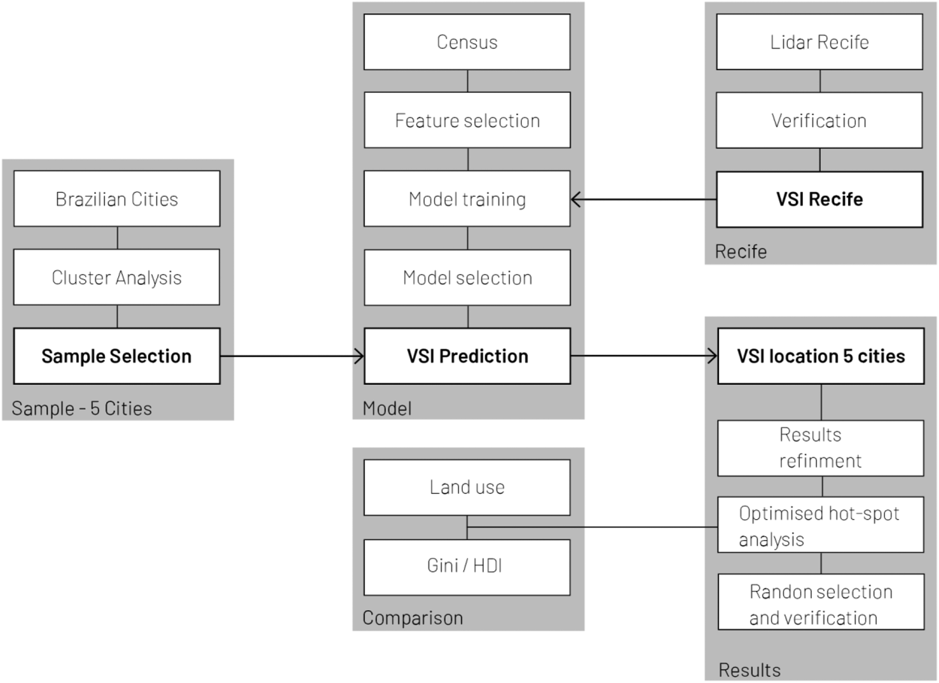
Feature selection
Before selecting the model with the best results, we went through an iterative process to select the best attributes to incorporate into the model. We tested the attributes in different combinations to understand and select those that were most informative. The final selection includes only attributes derived from the 2010 census. This decision guaranteed the uniformity and coherence of the dataset.
The final list of attributes is as follows: dwelling type (house, apartment or villa), population density, average household income and car ownership. We used this list to train our predictive model. The exploratory character of this research justifies the reduced set of parameters, as a complex model is not our primary objective. Instead, this paper aims to achieve an understanding of whether, when controlling for socioeconomic indicators, buildings in other cities share the same characteristics identified in Recife. The exploratory character is also the main reason for selecting an explainable model, which can provide weights for each attribute and better insights to the analyst.
Model training
We trained two different classifiers: one based on extra trees algorithms (extremely randomized trees; see Geurts et al., 2006) and one based on random forest algorithms (Ho, 1995). 4 This allows us to compare accuracy and feature importance and select the best model. Furthermore, since we are dealing with a dataset with imbalanced target labels, 5 we employed cross-validation and calculated the estimated balanced accuracy 6 to evaluate the model’s performance.
Accuracy and feature importance for trained models.
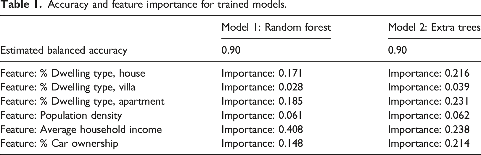
After the training phase, we used unseen data from Recife´s dataset to test the estimated balanced accuracy of the trained model. This testing phase shows that the random forest model is more sensitive to the income feature (0.408) and the percentage of the dwelling-type apartment (0.185). In contrast, the extra trees model shows more balance in the importance of each feature. Considering the relevant income differences across the cities that we are analyzing, we selected the extra trees model on account of its lower reliance on the income feature. This choice lends more importance to the attributes that are distinct for VSIs – dwelling type and income – without the risk of income-biased results.
Finally, we applied the model to each city in the dataset to predict VSI locations based on Census socioeconomic attributes. As already established, we only had information about VSI locations in Recife. No relevant ground-truth data were available for the other cities. Therefore, we employed this model – trained using data from Recife – to predict VSI locations in other cities affected by similar urban policies.
Output refinement and validation
The predictive model used in this study is a-spatial, meaning it does not directly consider the spatial location of each census tract or the influence of neighbouring tracts in the results. Therefore, once we obtained the results, we defined a three-step method to refine and validate the model output.
First, to incorporate a spatial dimension into the model output, we used optimized hotspot analysis on ArcMap (Ord and Getis, 1995). This statistical tool enabled us to identify significant areas and exclude outliers.
Second, we assessed the relationship between the presence of VSIs and three separate indicators: land use, Gini index and HDI (Human Development Index). We included the percentage of residential land use at this stage, following what we observed in Recife, where VSI presence has a positive relationship with monofunctional residential areas.
Third, we conducted a visual analysis of five per cent of the selected census tracts in the five considered cities. We used the most recent images available on Google Street View, only considering older versions when clarification was required. This visual analysis entailed coding buildings as VSIs (following the criteria detailed in the introduction) and ranking census tracts on VSI prominence from 0 to 5 (0 = total absence; 5 = over 75% of the buildings are VSIs). The classification is determined by dividing the number of VSIs by the total number of buildings.
Results
VSI in Brazilian cities
The VSI prominence rankings obtained by the predictive model are shown below. The figures for Recife are included as a reference.
The results show that the prominence of VSIs varies across cities. While Fortaleza, Salvador and Curitiba have rates similar to those of Recife, those of Belo Horizonte and Porto Alegre are substantially higher. It is worth noting that these two cities (together with Curitiba) are fairly affluent relative to the others in the dataset. Also worth pointing out is that Porto Alegre’s VSI rate exceeds even that of Belo Horizonte by a decent margin.
These preliminary findings suggest that our methodology is more effective for comprehending spatial fragmentation than a single-factor index such as Gini because our model incorporates several factors’ associations.
The differences in the results warranted additional analytical steps, including spatial mapping to evaluate the coherence and plausibility of the VSI locations, comparing each result with empirical knowledge about each city (see Supplementary Figure S12).
Refining and comparing the results
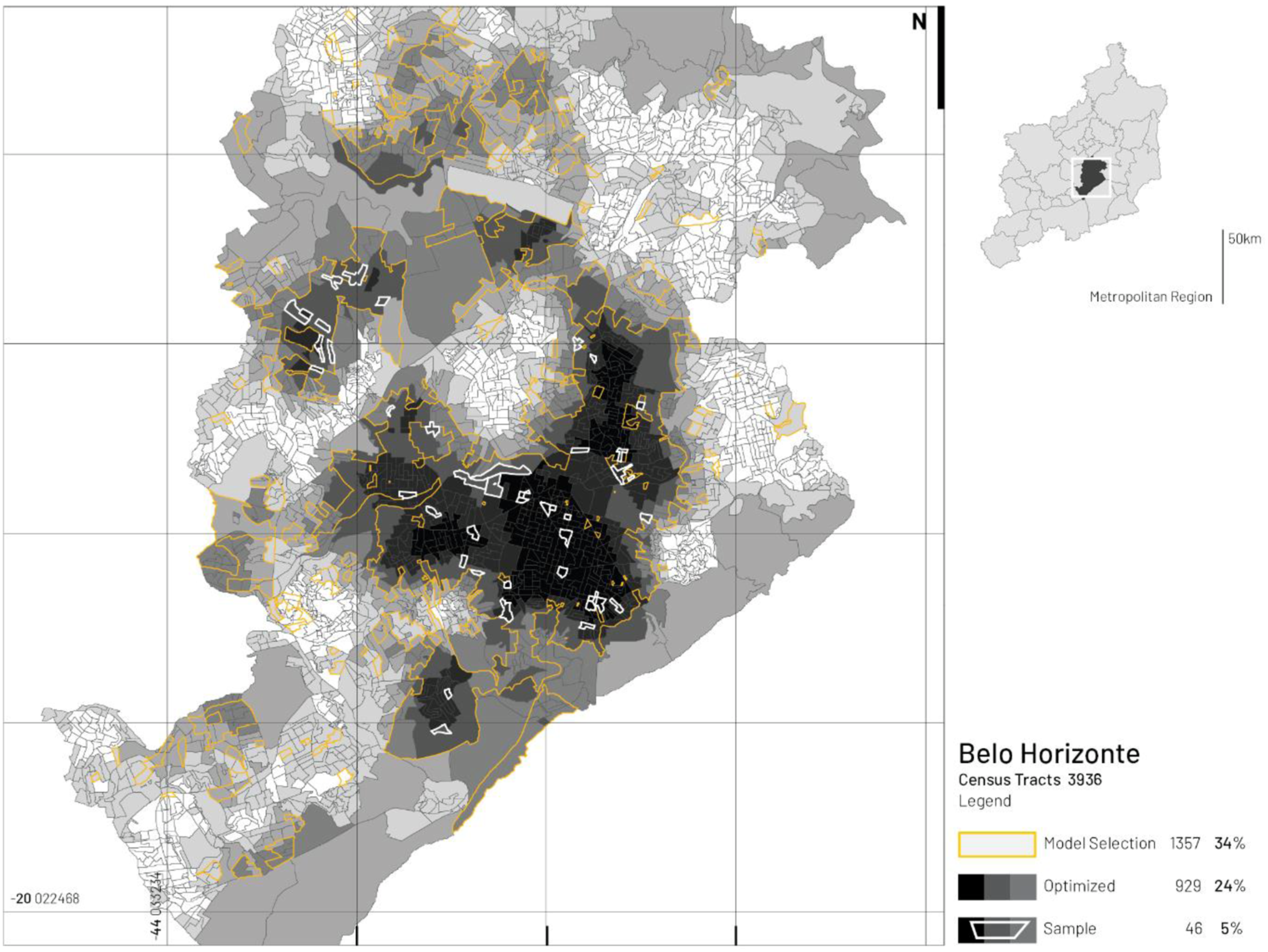
To incorporate a spatial dimension to the predictive model’s a-spatial output, we employed optimized hotspot analysis to highlight the areas of VSI concentration (see Figures 2 and 3 and Table 3). We refined the model results with this complementary step, identifying significant areas and excluding potential outliers. As a result, the revised figures lie within the range of Recife, 22% of the total census tracts, bringing Belo Horizonte and Porto Alegre more in line with the other cities. Map of Curitiba showing the steps used in the analysis: (a) model prediction, (b) optimized hotspot analysis, (c) selection of the most relevant results and random selection of 5% of the results. Map of Belo Horizonte showing the model results and the refining step. Summary of the results.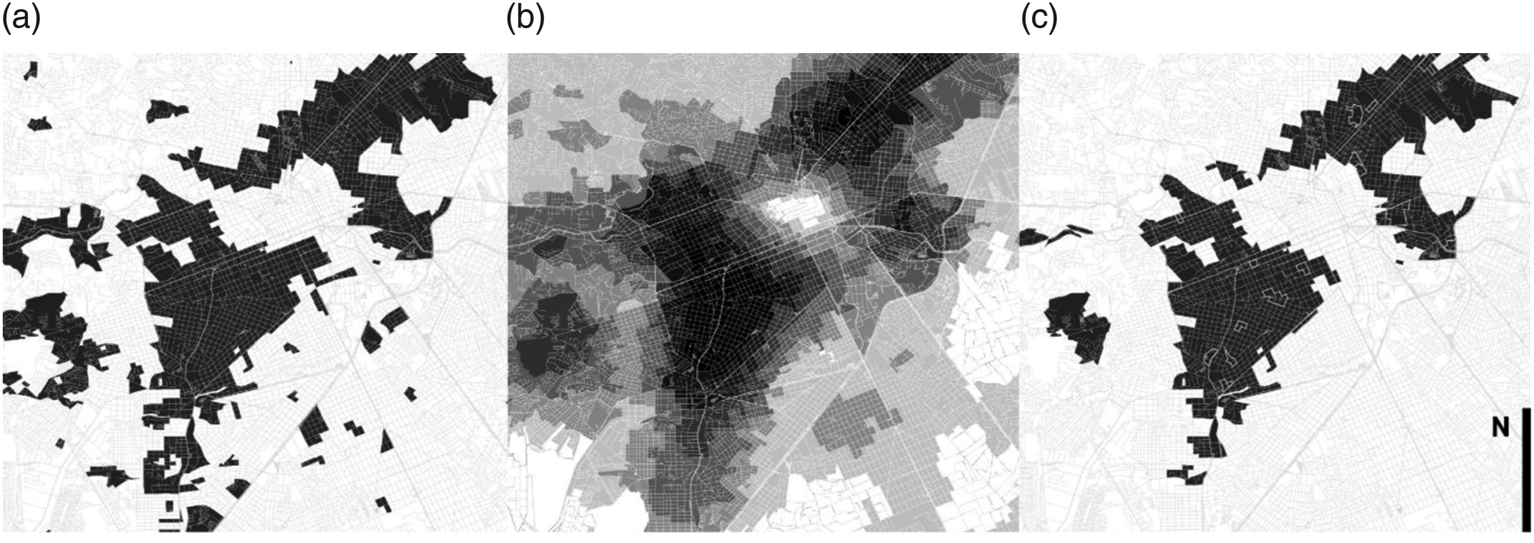
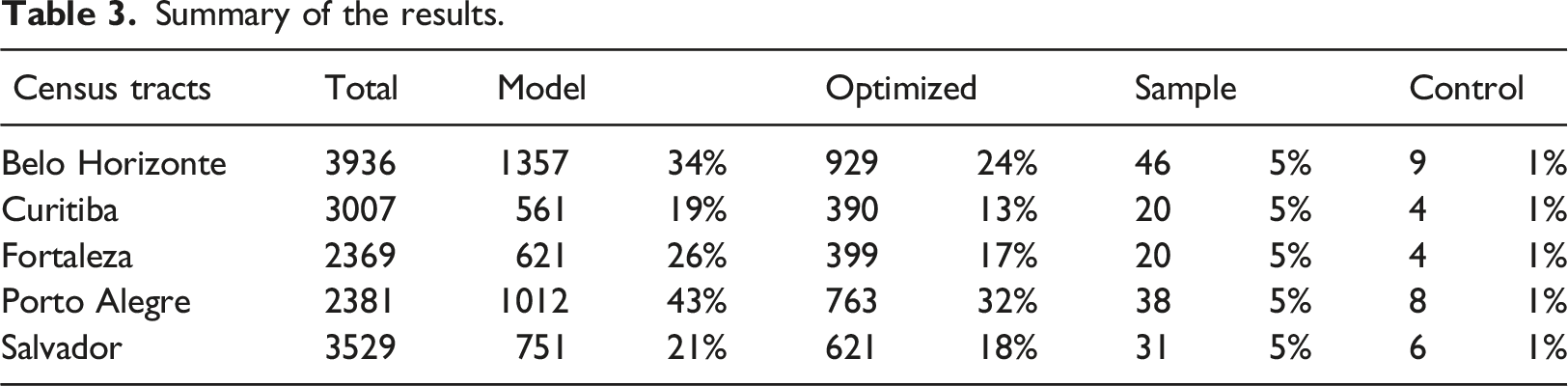
Assigned results for cities.

Comparing the results with city-level indicators
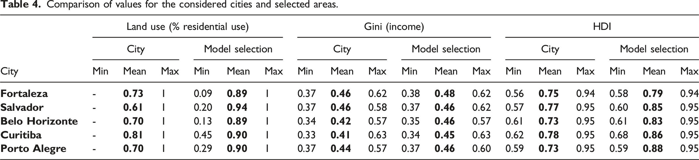
This step aims to understand how the model results perform at the city scale in terms of land use, income inequality and human development (see Supplementary Table S1).
Comparison of values for the considered cities and selected areas.
Verification of predictive model results
Finally, we conducted a visual analysis of the considered census tracts using a classification score (see Section 3.2 for more details). This score is intended to capture the variation and consistency of model outcomes. It is not intended to quantitatively validate the results.
Summary of the sample observation.
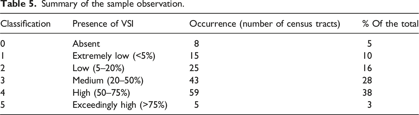
Of the 155 analyzed census tracts, only eight scored 0: including two in Curitiba, two in Belo Horizonte and four in Porto Alegre. Results in Porto Alegre and Curitiba are predominantly commercial areas with mixed-use and active ground-floor or suburban houses (Curitiba). In Belo Horizonte, the absence of VSIs may be attributed to the high rate of heritage-listed buildings in the considered area. At the other extreme, five tracts scored 5: four in Salvador and one in Fortaleza, both of which include large gated communities.
Discussion
This research demonstrated how to apply innovative analysis techniques to well-known urban issues as a means of providing valuable insights into modern urban development. The principal outcome of this research is that a machine-learning model was capable of detecting VSI prominence. While the spatial outlook observed in the samples may vary from large blind parking garages to fenced-off gardens, most of the analyzed samples denote structures intended to close off and disconnect buildings from the public realm. Our observations – both in Recife and the sample at large – showed that VSI retrofit and adaption are prohibitively expensive, making improvements impracticable. This is in contrast to prevalent scholarly arguments about adaptation and spatial capacity (Marcus, 2010), which praise the ability of urban spaces to accommodate a variety of activities over time with minimal adaptation.
The analysis of the sample—5% of the highest-scoring census tracts – demonstrates some trends and points of similarity. We can illustrate the most significant points regarding VSI and reflect on the contexts in which VSI buildings are constructed.
Fortaleza, Porto Alegre and Curitiba are all, to a certain extent, examples of cities in which the built environment surrounding VSIs has been impacted. In such cases, the introduction of VSIs can be associated with increased safety measures, such as higher walls and barbed wire. Additionally, some solutions used in VSIs, such as electric gates and surveillance cameras, are gradually integrated into pre-existing structures.
Worth noting is that we noticed several vacant buildings and closed shops near VSIs. We do not mean to assert that there is a causal relationship here. VSIs may simply be newer than those in their immediate vicinity. Still, without a temporal assessment, it is impossible to determine whether VSIs aggravate local environments or whether VSIs are simply more likely to be constructed in areas already in decay.
We also identified cases in which VSIs coexist alongside neighbouring interfaces with active ground floors featuring shops, cafes and other public services. This type of coexistence appeared to be most prominent in Curitiba and Porto Alegre; it was seldom found in areas with multi-floor buildings alongside individual houses. This dynamic may reflect the development process of areas previously occupied by detached residences. The remaining houses are no longer attractive for residential use and, eventually, undergo functional shifts.
We may also make some general observations regarding VSI features. Interfaces of older buildings that were once open to the public are gradually closed, with improvised solutions later incorporated. Interfaces of newer buildings incorporate these design strategies to control access. We noticed similarities across the sample in VSI designs. For example, many interfaces featured plinths exclusively used for parking; others featured linear enclosed gardens. Also worth noting is that there was a distinct lack of mixed-use functionality among VSIs.
On a different note, our analysis identified some possible coexistence scenarios for active frontages and VSIs. In Curitiba and Belo Horizonte, a correlation between VSIs and road profiles was established. In these two cities, VSIs were typically located alongside local roads, whereas active frontages were typically located alongside main roads or transit corridors. While this apparent association was most pronounced in Curitiba and Belo Horizonte, it was observed in practically all of the cities analyzed.
While relatively infrequent, we detected another VSI variation in Belo Horizonte and Curitiba. We came across several buildings with VSIs on most facades but with active corners housing storefronts in these two cities.
In summary, the study of VSIs allows for a more nuanced understanding of the urban environment’s capacity to respond to conflicting demands. As already stated, the study of planning instruments is crucial to understand why and how municipal regulations prevent, allow, or even push VSIs.
One limitation of this work is that it did not achieve an understanding of whether local characteristics respond more to local or global factors. That was remarkable in the sample observations, where interfaces changed regardless of local context. One potential approach to addressing this limitation would be to compare local characteristics (such as VSI prominence) with global measures, such as centrality (Hillier, 1999). Another potential avenue for future research is to review planning regulations in the six cities studied here to analyze how VSI profiles are normatively addressed at the municipal level.
Conclusion
Despite the extensive literature on spatial fragmentation in Brazil and Latin America, VSIs remain under-analyzed. This research employs a novel approach by processing, analyzing and modelling existing data to address this gap in the literature. This paper presented an exploratory process to detect VSIs across six Brazilian cities using sociospatial data and a machine-learning technique to build a classifier model that can automatically predict VSI prominence in cities for which this spatial information is not available.
This work employed a complementary approach, making it distinct from urban morphometrics studies that use urban form classification to detail the socioeconomic characteristics of cities (e.g. Araldi and Fusco, 2019; Bobkova et al., 2019; Dibble et al., 2019). By using socioeconomic parameters as a starting point, this study contributes to a better understanding of urban form and type emergence. However, one drawback of the methodology is that census data is organized in tracts that do not always correspond spatially to urban morphology features like urban blocks. Future research on VSIs and morphology must address this spatial disconnection.
The detailed study of the samples revealed consistency in the model results, identifying areas with high VSI occurrence. The model also performed well on a city scale, as confirmed by comparing land use data and social indicators.
The approach used here to combine ground-truth and open data in a predictive model could be extended to other cities. Although street-interface research has been conducted in various Brazilian cities (e.g. Alonso De Andrade et al., 2018; Holanda, 2002, 2007; Maciel and Zampieri, 2020; Saboya et al., 2015), existing studies lack a common framework and face severe limitations in terms of ground-truth data collection and observation. Future research should incorporate open-source mapping platforms to develop a shared database of street-interface types. This step could be crucial for future research using predictive models based on open-source data and volunteered geographic information (Milojevic-Dupont et al., 2020).
Supplemental Material
Supplemental Material - Understanding and predicting the occurrence of void street interfaces for Environment and Planning B
Supplemental Material for Understanding and predicting the occurrence of void street interfaces by Luiz de Carvalho Filho by Patrizia Sulis in Environment and Planning B.
Footnotes
Declaration of conflicting interests
The author(s) declared no potential conflicts of interest with respect to the research, authorship, and/or publication of this article.
Funding
The author(s) received no financial support for the research, authorship, and/or publication of this article.
Supplemental Material
Supplemental material for this article is available online.
Notes
References
Supplementary Material
Please find the following supplemental material available below.
For Open Access articles published under a Creative Commons License, all supplemental material carries the same license as the article it is associated with.
For non-Open Access articles published, all supplemental material carries a non-exclusive license, and permission requests for re-use of supplemental material or any part of supplemental material shall be sent directly to the copyright owner as specified in the copyright notice associated with the article.