
Abstract
A frequent criticism of knowledge-based planning tools is the apparent mismatch between information frameworks used in their spatial models and the information needs of planning actors. Increasingly, these actors are contributing their context-specific knowledge during the development of such tools. Transferring this knowledge from actors to the model remains a challenge. This study establishes a set of design requirements for knowledge elicitation in small group settings and introduces game co-design as a method allowing planning actors and planning support experts to meet halfway between the technology and user domains in the so-called third space. We present an initial case where in three nominal group sessions, actors encountered and critiqued parameterized assumptions of their planning issues in a tangible game environment. Findings indicate that the method can elicit different types of knowledge (divergence) about a spatial system in operationalized terms (formalization). We discuss the potential of tangible game co-design as a modeling as learning exercise and its complementarity to dedicated digital technologies for more holistic planning support.
Introduction
Models have made an indelible mark on the practice of spatial planning. This practice utilizes models and other knowledge-based technologies to gain insight into causal relations within a given context through the production, transformation, and transmission of knowledge (Gudmundsson, 2011). Spatial models represent knowledge of various systems (e.g. housing, amenities, transportation, and land uses) in bi-space, a term that refers both to space and its attributes (Wegener, 2001). These models help actors to understand (urban) spatial systems and what Healey (2007) describes as their “dynamic relational networks, transecting and interweaving with each other” (p. 220). As the complexity of spatial systems grows, planners require tools with the capacity to support the visualization and analysis of these systems. Increasingly, there is a need for tools that, like the practices they support, are flexible and can adapt over time to deal with unfolding uncertainties and issues that are strategic and non-routine (Batty, 1995; Rauws and De Roo, 2016). Such tools, particularly those that integrate (geo)information-based spatial models, however, are noticeably absent during strategic planning stages when dialogue and learning are key (te Brömmelstroet and Bertolini, 2008).
To gain a broader adoption of these tools in practice, situating spatial models to their intended contexts of use is key. This means that during the strategic stages of planning, support tools must be embedded in practices that deal with what Rittel and Webber (1973) term “wicked” planning problems that have no scientific solution, only resolution. Biermann (2011) asserts that the issues of planning actors related to these problems could be “the most relevant contextual factor” impacting the content-related quality of these tools (p. 11). Interactor communication about wicked problems could be informed by models that, as Batty (2013) suggests, incorporate simplified modeling rules and that are used in defining the salient features of systems. Numerous techniques for eliciting knowledge about complex systems from system experts have been advanced under the header of group model building (GMB) (see Voinov and Bousquet, 2010). However, most GMB techniques have shortcomings that relate to their ability to capture the divergent mental models of actors, particularly in group settings, and to operationalize their knowledge for formal modeling (Ford and Sterman, 1998).
Models in the form of roleplaying games are particularly effective in representing the complexity of a system and in facilitating social learning (see Pahl-Wostl and Hare, 2004). Specifically, simulation games represent complex, real-world systems and their actor networks through simulated physical or virtual reality (Duke and Geurts, 2004; Lukosch et al., 2018). An early example of a simulation game for future-oriented planning is METROPOLIS (Meier and Duke, 1966). The authors highlight the informative value of the game model over a computational model when there are uncertainties about the range of possibilities and a lack of consensus on perceived quality. More recent digital games like “B3-Design your Marketplace” have improved civic engagement through playful learning among actors about planned changes to an environment where traditional geographic information systems (GIS) functionalities were deemed too complex (Poplin, 2014).
Two channels of “multilogue” communication are important for game design: that among participants while playing the game and that between the user and the game designer during game design (Duke, 2011). In a similar vein, next to dedicated tools that supportinteractor communication in strategy-making processes, there is a need for spaces that facilitate communication between planning actors and planning support experts when building or situating these support tools. Such a space has been introduced in co-design literature as the third space, which shares features of both the technology developer and user domains (Muller and Druin, 2002). So far, applications of game co-design to spatial planning are preliminary but promising (see Ampatzidou and Gugerell, 2018). An exploration into co-design in the third space could contribute to the debate on how to contextualize the underlying spatial models of knowledge-based planning tools. This could be achieved with more pragmatic, design-oriented research to grasp the relationship between the mechanisms of such dialogue structuring methods, context, and outcomes (te Brömmelstroet and Schrijnen, 2010).
This paper explores the use of a tangible game co-design environment for the elicitation of context-specific knowledge about planning issues in formats suitable for use in a spatial model. We call this environment the game third space. Like spatial models, the game third space includes a set of underlying parameterized assumptions about the spatial system under investigation, but in an immersive and playful format, which actors can critique and revise. The purpose of this study is threefold: (1) to establish a set of design requirements for a game-based method for knowledge elicitation, (2) to provide a detailed description of a game co-design method including an illustration of it in use, and (3) to determine whether the method provides an effective means to elicit the sought-after knowledge about a local context.
The structure of this paper is as follows: The next section operationalizes key terms concerning knowledge elicitation during model building followed by the introduction of design requirements for the game co-design method. After describing the method, we report on critiques provided by planning actors of the parameterized assumptions and the game rules. The paper concludes with a discussion of the extent to which the game co-design method fulfilled its intended purpose of eliciting knowledge from system experts, in terms of both formalization and divergence, and provides recommendations for continued research in the realm of game-based GMB and hybrid planning support tools.
Operationalization of key terms
Knowledge elicitation for model building concerns the retrieval of knowledge from the mental models of system experts. Mental models contain knowledge about issues pertaining to the functioning of a system and the basis for individual action (Rouwette et al., 2009). Knowledge elicitation mainly deals with what Nonaka (1994) describes as the externalization of tacit knowledge in explicit, codified terms. Two dynamics of knowledge elicitation that are important for situating model building within a strategy-making process are formalization and divergence.
Formalization
Spatial models vary in their degree of formalization. As knowledge about system components and their relationships becomes formalized, its depiction using quasi-natural language is operationalized into mathematical constructs (Wegener, 2001). Beforehand, relationships between variables of these components must be mapped, and model parameters must be quantified (Vennix et al., 1992). Andersen et al. (2007) described the formalization processes in GMB settings as a double-edged sword. On the one hand, if not properly facilitated, the structure of the formal model can stifle emergent communication. This statement indicates a need for techniques with low-technology thresholds to maximize the opportunity to elicit knowledge from system experts. On the other hand, the formal structure can apply “sensitivity checks and other cross-checks” (Andersen et al., 2007: 693). Cross-checking modeler estimates with knowledge from system experts can improve model credibility in the eyes of the intended users (Ford and Sterman, 1998).
Divergence
Divergent thinking is essential when engaging groups and individuals in determining the boundaries of the system (Vennix et al., 1992). Divergence involves the generation of a wide variety of ideas based on individual contributions (Dennis and Wixom, 2002). When planning is in its early stages, divergence and shared learning about the system is more the focus than converging and decision making (te Brömmelstroet, 2017a). Staffans et al. (2020) outline two types of knowledge divergence that should be supported in multi-actor planning processes. The first is the production of diverse data, ideas, and information sourced through large-scale participation of the broader public. Map-based surveys and public participation geographic information systems (PPGIS) are effective tools for capturing this diverse knowledge. The second is the collection of knowledge and ideas from diverse smaller groups that can be further elaborated—the focus of this paper.
Four aspects of divergent thinking that can be captured in rapid brainstorming with diverse smaller groups are: frames, domains, abstraction levels, and uncertainties. Planning actors use frames to filter and make sense of specific issues and their relationships (Dewulf et al., 2009; Matos Castaño, 2016). Frames about these issues may be expressed as perspectives pertaining to an issue or preferences and priorities of one option over another. The frame an actor uses to examine a problem can also reflect his or her domain of systematic-scientific expertise (Alexander, 2008). Actors apply their different domains of knowledge to different types of planning tasks. These tasks include non-routine tasks for preparing strategies over long periods or routine tasks for planning incremental change (Batty, 1995). Whether actors are dealing with routine or non-routine tasks may determine the level of abstraction (i.e. operational or strategic) from which they view planning issues (Geertman, 2006). There are many uncertainties about the knowledge used by different actors in planning, and strategy making in particular. Identifying uncertainties concerning what is unknown, not understood, undisputed, and hidden is an essential part of modeling and determining what model input may be genuinely helpful (Couclelis, 2005).
Requirements for a game-based method to elicit context-specific knowledge
Based on a literature review of knowledge elicitation methods from multiple disciplines and the key terms operationalized above, this section outlines seven design requirements for a game-based method that supports multilogue communication between planning actors and support experts, which are as follows:
Requirement 1: Embedment of model building in future-oriented tasks of spatial strategy making by means of a structured dialogue
As designers move closer to the intended users of their products, the front end of the design process is becoming increasingly open (Sanders and Stappers, 2008). This openness is reflected in planning support tool development approaches that are oriented toward the support of dynamic early-stage planning tasks (see te Brömmelstroet and Bertolini, 2008; Vonk and Geertman, 2008). The general purpose of strategy-making tasks such as visioning, storytelling, and scenario development is to influence the path of dynamics occurring in a spatial system (Couclelis, 2005). Uncertainties about desirable alternative futures can introduce complexity and ambiguity into these tasks. Actor involvement in the design and development of planning support tools including their underlying models is seen as a means of creating a better fit between tool and process being supported (Russo et al., 2018; Vonk and Ligtenberg, 2010). te Brömmelstroet et al. (2014) have emphasized the demand for structured flexibility that involves actors in making important choices while working with more flexible information models. Mediated planning support was developed as a facilitated method to structure the dialogue between domain experts and planning support experts by adjusting the generic features of an existing model (te Brömmelstroet and Schrijnen, 2010). In doing so, the method has helped to imbed tool development in the complex reality of strategy-making tasks.
Requirement 2. Representation of both the expertise of planning professionals and the experiential knowledge of citizens
Of the many types of knowledge (see van Ewijk and Baud, 2009), two types that are particularly relevant for developing spatial models are expert and experiential knowledge (Friedmann, 1993). Expert knowledge is a form of knowledge that is commonly applied in spatial planning (Pfeffer et al., 2011). Residents are often associated with experiential knowledge about a local area (Kyttä et al., 2011). The inclusion of experiential knowledge in planning generates more robust arguments through the interplay of what strategy makers say and the knowledge of those who have a stake in the area (Healey, 2007). Participatory methods have been linked to GIS for mapping and sharing this knowledge spatially. SoftGIS methods, for example, excel in capturing localized experiential knowledge for statistical analysis and systematic GIS (see Kahila and Kyttä, 2009). Next to SoftGIS methods, which produce divergent knowledge about an area from many individuals, methods are needed for rapid brainstorming from diverse small groups in a workshop setting as a foundation of divergent knowledge for further planning phases and planning support (Champlin, 2019; Staffans et al., 2020).
Requirement 3. Parameterization of (non)spatial issues and the specification of relations using multiple description formats
Sterman (1994) claims that the only way to learn about complex systems is by eliciting knowledge about these systems and simulating their dynamics. It, therefore, follows that if learning about a spatial system is the aim, planning actors and their knowledge should be more involved in setting parameters and models (Pelzer, 2017) of these systems. GMB encompasses numerous techniques to elicit knowledge about system components and their relationships from system experts. In many cases, however, GMB approaches fall short of estimating the “parameters, initial conditions, and behavior relationships that must be specified precisely in formal modelling” (Ford and Sterman, 1998: 309). Engagement in formal modeling can be supported by letting actors propose modifications to a preliminary version of the model. However, Voinov and Bousquet (2010) caution the use of sophisticated software that is difficult to learn and use for this purpose. Instead, spatially explicit formalization of issues can be facilitated through the use of multiple description formats. A triangulation of descriptions—e.g. verbal, textual, and spatial—can improve information quality as actors seek consistency and descriptions are compared (Ford and Sterman, 1998).
Requirement 4. Idea generation or divergence through multiple, individual descriptions of the spatial system to reduce the risk of group-think and premature convergence
Knowledge elicitation methods such as GMB are popular means for identifying system components and their relationships. These methods are usually conducted in group settings. Since interacting groups tend to inhibit divergent thinking, nominal groups of one or two individuals are preferred for idea generation over group brainstorming (Vennix, 1999; Vennix et al., 1992). Nominal group work reduces the risk of group-think and premature convergence (Ford and Sterman, 1998). Both are thought to impede group work while limiting the extent to which different frames and other aspects of divergence can be elicited from actors.
Requirement 5. Use of a model in a preliminary state so that actors are able to recognize and critique model assumptions
One means of structuring the dialogue between planning actors and support experts is through the exploration and critiquing of model assumptions before they are developed into mathematical constructs and entered into evidence-based knowledge technologies. Goodspeed (2016) found that actors perceived their role in questioning assumptions and ensuring that planning support tools reflect their unique issues to be more important than their contribution to the technical aspects of model development. By removing the technical-functional aspects that actors often consider too sophisticated and intimidating (see discussion in Al-Kodmany, 2001) from model building, more focus can be given to communication about planning issues and eliciting knowledge about them. Working with a preliminary model can help to structure model-building tasks by encouraging actors to redesign flawed parts of the model (Vennix et al., 1992). Using models with simplified rules and lowered explanatory power may also help actors to relate their inputs with model outputs (te Brömmelstroet, 2017b). A recent study on the use of different planning support methods found that actors working with a preliminary model could more easily recognize assumptions and adopt the formal language used in the model when suggesting changes (Champlin et al., 2018).
Building on these knowledge elicitation methods, we introduce two additional design requirements centered on the notion of models in the form of games. These requirements are as follows:
Requirement 6. Use of a game environment as a third-space platform with hybrid features of both the user and technology domains
Sterman (1994) describes formal models as “virtual worlds” where decision makers can refresh their skills, experiment, and play for learning about complex systems (p. 27). Serious games fit this description of a formal model, with the additional capacity to immerse actors in a real-world simulation of their planning issues imbedded in wicked problem contexts. Games can simulate both socio-political and technical-physical networks of complex systems (Raghothama and Meijer, 2015), and they offer a means to deal with problems where traditional scientific techniques are inadequate (Armstrong and Hobson, 1973 as cited in Duke, 2011). Games that function as planning support tools can also incorporate games rules that reflect the policies that govern the city (Raghothama and Meijer, 2015). Games, particularly those in a preliminary state, fulfill the core features of third spaces in that they provide a platform for reciprocal learning, idea generation, and challenging assumptions (Muller and Druin, 2002).
Requirement 7. Facilitation that structures communication interactions about planning issues and supports individual work
Planning processes that are open to input from an array of actors and their issues can often stall in the early, exploratory stages requiring flexible, pragmatic interventions to move the process forward. Wilson and Tewdwr-Jones (2020) caution the use of technology in these early stages, as they can create additional usability barriers, particularly when dialogue and learning are key. What has proven beneficial in these early stages are facilitated group sessions that employ simpler, more flexible information models to support a structured dialogue (Champlin, 2019; te Brömmelstroet, 2012). Facilitating such sessions involves structuring interactions among actors, tools, and the tasks they support (Pelzer et al., 2015). Games and gamified applications may be adopted more broadly in planning processes when facilitators become more adept at administering such tools and determining appropriate situations for use (Ampatzidou et al., 2018). Champlin et al. (2018) suggest that, given the demand for knowledge technologies with more adaptive information frameworks, facilitated interventions that limit the number of variables under consideration and support individual work may be important both for planning quality and tool adoption.
Game co-design method and results
In this section, we describe the main components of the game co-design method and report the results of an initial use case based on the dynamics of knowledge elicitation, namely issue formalization and the four aspects of divergence, i.e. frames, domains, abstraction levels, and uncertainties.
The game co-design method
The proposed game co-design framework (Figure 1) integrates the abovementioned design requirements into a third space for planning actors to share their knowledge with support experts. Content is developed based on a preselected subset of planning issues (for more about issue selection methods, see Champlin et al., 2018). These issues and their relationships are displayed as model elements—i.e. actors, flows, facilities, investments, and regulations—instead of GIS primitives (see Hopkins, 1999) so that actors can easily identify the issues. Multiple views of the elements are provided to permit a triangulation of knowledge. These views include an interactive map on a tablet device, a multi-attribute table, and physical game components. The views are used to elicit verbal, textual, and spatial descriptions of the planning issues. Actors have the freedom select one or more of these views when critiquing parameterized assumptions.
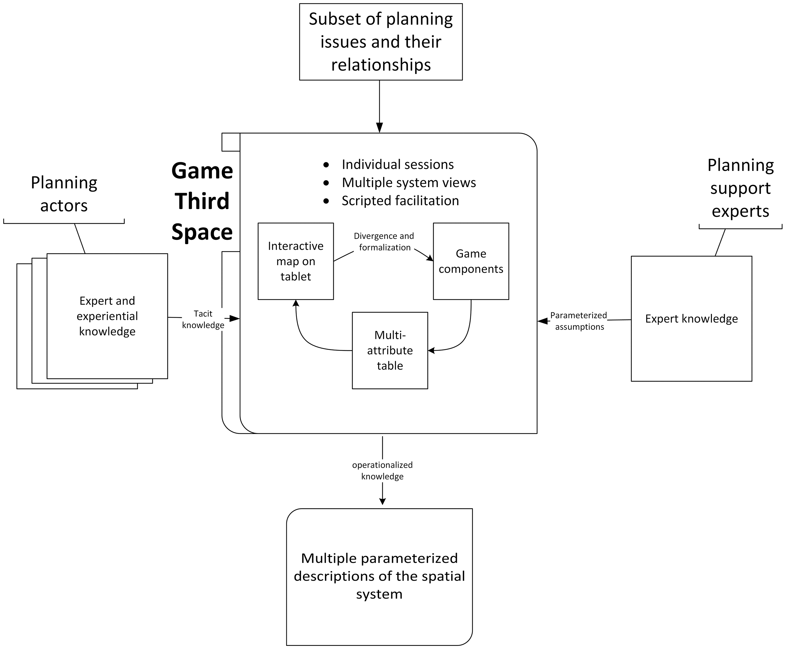
The game co-design framework featuring the game third space for knowledge elicitation.
The method consists of two design stages: (1) ex ante game development and (2) critiquing parameterized assumptions within the game third space. In the first design stage, planning support experts develop the game third space based on informed assumptions about a spatial system. The second design stage is conducted in individual-facilitated sessions with different groups of planning actors. The facilitators follow a script when eliciting descriptions of the system in its current and future states. The scripted questions and statements guide the actors through the application of their expert and experiential knowledge when critiquing the parameterized assumptions incorporated in the game third space.
Illustration: Co-designing the Kennistrekker game environment
In the spring of 2018, we hosted facilitated groups sessions with the City of Enschede and its stakeholders to develop a housing forecast, which was a highly contested topic. The housing forecast was part of a strategic redevelopment project of the Innovation Campus Kennispark, a 180-hectare science park that includes a Dutch technical university and many high-tech and services companies. An agreement on the projected number, typology, and location of new housing in the area was needed as a basis for determining necessary changes to the land-use plan. Based on observations of several meetings, we concluded that three main factors were interfering with the development of the housing forecast: (1) different actor groups using different means of categorizing and assessing the housing demand, (2) insufficient cross-checking of expert planning knowledge with the experiential knowledge of future dwellers, and (3) lack of a shared strategic vision for the redevelopment of the Kennispark.
To address these factors, we conducted three knowledge elicitation sessions following the game co-design method described above, first with an urban planner and urban designer from the City (the planners), then with two university facility managers who were involved in determining student housing demand and finally with two members of the university student board (the students). These planning actors critiqued the underlying assumptions included in the Kennistrekker game environment. Relationships between the future demand for housing and the supply of new facilities and infrastructure can be explored both spatially and non-spatially in this game third space. This exploration process is structured through the use of a subset of planning issues. These issues were selected during a strategy-making session with the Kennispark spatial development group, which the authors facilitated on September 2017.
We derived most parameterized assumptions about the planning issues from notes taken during a housing meeting on January 2018. We filled in information gaps using our own expert planning and game design knowledge to generate player profiles and to set limitations and rules for gameplay. We expected that many of our assumptions would be incorrect or incomplete and that the actors would critique and redesign what they considered flawed parts of the game.
Figure 2 shows the three views of the parameterized assumptions—game components (the game board, 4 dweller cards, and 13 action cards), an interactive map on a tablet and a multiattribute table—that were developed to help the actors describe the spatial system verbally, textually, and spatially. The interactive map on the tablet was the view that was least used by the actors. Instead, the actors frequently referred to the raster map on the game board to communicate spatially about issues, both in terms of the current situation and future possibilities, and to sketch relationships between components. The planners, in particular, worked with the game board to communicate their critiques, which were mostly strategic and future-oriented. The facility managers worked primarily with the multiattribute table. Most of the knowledge elicited from them was domain-specific about the operational aspects of student housing. Specifically, the facility managers spent significant time checking that the dweller attributes (e.g. number of units and household budgets) matched their own housing quotas on Excel sheets. The multiattribute table provided a textual view of the planning issues in formalized language, which the actors would emulate when verbally and textually formulating their critiques.
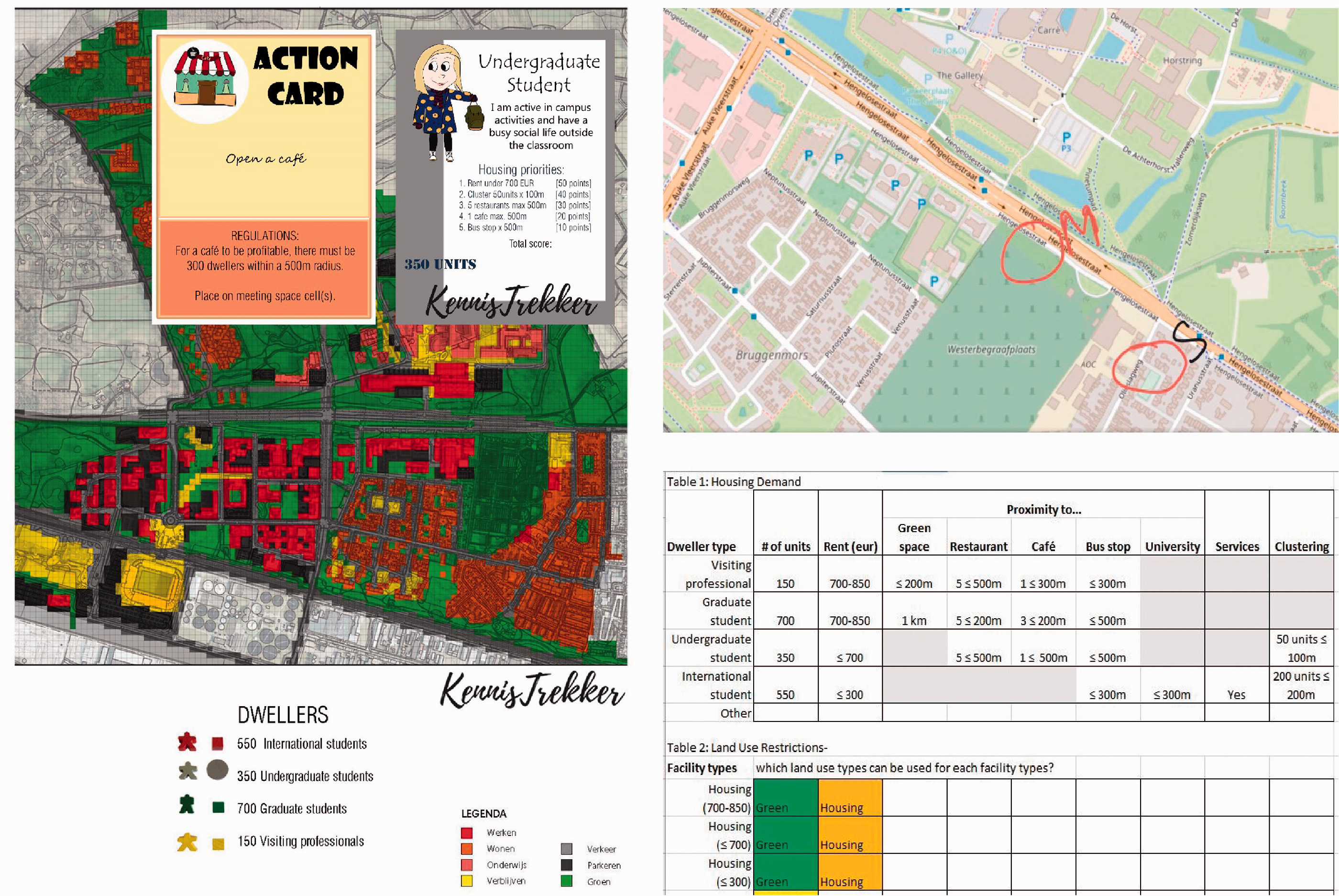
The three views of the parameterized assumptions.
From a divergence viewpoint, the actors primarily critiqued assumptions that were related to their own knowledge domains. Supplemental Table S1 shows that the students and facility managers critiqued the classification of dwellers and nearly every attribute related to housing demand. Both groups proposed new classifications based on rent thresholds; however, they parameterized these assumptions differently. The students stated that the housing demand assumptions for students did not reflect how they framed the issue and suggested that students should have been involved in setting the priorities of the undergraduate student character. The distribution of critiques across the facility supply assumptions matrix (Supplemental Table S2) further indicates that the actors limited their critiques to their own knowledge domains. The planners applied their expert knowledge, both strategic and operational, to critique the facility supply and land-use assumptions. Of the 11 changes to assumptions about land uses, the planners critiqued 8, while the students only critiqued one. The two changes to the land uses made by the facility managers reflected the operational-level, domain-specific character of their knowledge about regulations, buildings, and infrastructure on campus. For example, the facility managers added a piece of land belonging to the university campus that was not included in the raster map provided by the planners.
Next to divergent thinking, the game co-design method also supported the elicitation of formalized knowledge about relationships between issues. Contributions to the facility supply assumptions matrix show that the actors not only critiqued our parameterized assumptions, but they also helped to fill in gaps where we had not yet formulated assumptions about the relationship between issues. The view most commonly used by the actors to externalize their knowledge about these relationships was the game components, specifically the game board and action cards. All three of the actor groups formalized relationships between spaces for work and study and service facilities. For example, the planners suggested to cluster restaurants and cafés with other facilities, while the students stated that most students do not have the finances to eat in restaurants and that they prefer instead to have a supermarket nearby that also carries imported products. Like the facility managers, the students wanted more options such as food trucks that served lunches and cafés for meeting with friends on the weekends. Both the planners and the students adjusted parameters about the viability of restaurants and cafés. These parameters were based on the number of housing units—the data we had available—which, according to the actors, would have excluded a large number of daytime customers working and studying in the area. Instead, these actors suggested to allocate restaurants and cafés based on the number of potential customers.
Findings indicate that working with parameterized assumptions about the planning issues in nominal groups facilitated divergent thinking. Separate discussions with the actor groups revealed differences in the way the actors framed and formalized the accessibility issue compared to our own assumptions. Instead of modeling proximity in terms of radius in meters, the actors suggested several alternative means based on travel time and transport mode. The planners based their framing of accessibility on prior knowledge of student behaviors at other Dutch universities, while the students based their framing of the issue on personal experience and that of students they know. The planners suggested to locate all facilities for daily use (i.e. living, working, education, meeting spaces, cafés, and restaurants) within a 5-minute biking or walking radius from housing. When we cross-checked their expert knowledge with the experiential knowledge of the students, we learned that the 5-minute cycling distance was applicable to Dutch students but that most international students preferred a 5-minute walking distance.
The actor groups used different frames of the issues to critique our assumptions about the facilities that should be located near housing. The facility managers stated the café issue was not a priority for dwellers, whereas the students themselves expressed a need for more cafés on campus. The planners put forth a different proposal to include cafés in a combined hotel, restaurant, and catering concept (horeca) in the business park area adjacent to campus. In another instance, the facility managers agreed with our assumption to place housing within 300 meters of classrooms, while the students preferred to create a “noise buffer” between on-campus housing and spaces for work or study, explaining that students were willing to travel up to three kilometers to their classes. This again demonstrates the cross-checking of expert knowledge with experiential knowledge that the method facilitated.
While critiquing the game rules using the game components, relationships between the parameterized assumptions and regulations were formalized spatially as the actors changed land uses, allocated facilities, and housed dwellers (see Supplemental Figure S1). This experimentation in rapid scenario development allowed the planners to reflect on uncertainties about their area redevelopment strategy. Specifically, measuring out areas and distances on the game board allowed the planners to explore the design of a “model cluster” of facilities in terms of dimensions, composition of facilities, and occupancy levels. We identified complementarity between levels of knowledge abstraction, specifically regarding the integration of operational-level knowledge about the state of housing demand from the facility managers into the strategic discussions of the planners concerning the clustering of facilities for dwellers, workers, and students.
The flexible game rules allowed actors to play the game based on their own domains of knowledge, levels of abstraction, and framing of issues. Process and tool-related facilitation brought structure to the free play of critiquing the game rules. Together with the actors, we decided that rather than create a game with a fixed set of game rules, the rules of play should remain open so that how the game is played is determined by the learning objectives of the players. Each group of actors indicated an interest in playing the game with the other actors once it was complete. The facility managers stated that playing the game with the planners may help the two sides communicate better.
Discussion and conclusion
This paper documents the development, application, and evaluation of a game co-design method for the elicitation of context-specific knowledge from planning actors during model building. It responds to an omission in planning support literature identified by te Brömmelstroet and Schrijnen (2010) where engagement in pragmatic, design-oriented research is needed to grasp the relationship between the mechanisms of dialogue structuring methods, context, and outcomes. We have explored the potential of game co-design as a means of building simpler, contextualized models given that attempts to capture the complexity of spatial systems in large-scale models are considered flawed (Lee, 1973). Still, the ambition toward hypercomprehensive models persists (te Brömmelstroet et al., 2014). Citing the apparent mismatch between the information frameworks of planning support tools built upon such models and the information needs of planning actors, we introduced a game third space where actors and support experts can meet halfway between their domains of expertise to engage in learning and communication. This third space approach serves as a method for collaboration among tool experts and non-experts as suggested by Vonk and Ligtenberg (2010).
By applying flexible game rules and easily recognizable parameterized assumptions derived from a limited number of planning issues, the game co-design method provides a framework for both sides to engage in a structured dialogue. Though not conclusive, we believe the choice by all three nominal groups not to sketch exploratory ideas on the tablet indicates a preference for low-technology tools during issue parameterization. Planning support experts could become more adept at facilitating tangible game use as a simpler, more flexible means of rapid scenario development and evaluation of outcomes. Facilitation will likely continue to play an important role in mediating discussions triggered by the use of games and simplified models, in general. More structured facilitation of content, process, and tool use may support the uptake of these adaptive planning support tools in small group settings like the one described in this study (see also Champlin et al., 2018).
Meeting separately with the different actor groups raised our awareness to the ease with which biases can enter the underlying assumptions of a spatial model. The parameterized assumptions we entered into the game third space seemed more in alignment with the frames and knowledge domains of the planners than those of the other actor groups. This alignment suggests that our own knowledge of the project under investigation was likely influenced by previous conversations and encounters with the City of Enschede planners, but it may also reflect our own training as planners. At the same time, the level of abstraction of our assumptions was mostly operational, which matched the operational-level knowledge of the facility managers. Such biases reflected not only our own interpretation of the knowledge and information made available to us prior to the sessions but also the biases often represented in models at large. Potential benefits of making these biases explicit and cross-checking it with system experts during the early stages of model building may be improved model calibrating, sensitivity testing, and the determination of parameter ranges and thresholds as well as greater transparency and trust in model outputs (see Ford and Sterman, 1998). Such exercises in divergent thinking with multiple actor groups are important in the early stages of both model building and planning alike, and they deserve more attention from academics throughout the various stages of both processes.
Recent studies have also pointed to a need for more research into the development and testing of planning support tools that are designed to support individual work and their integration into communicative planning processes (see Champlin et al., 2018). Russo et al. (2018) identified a paucity of studies evaluating the individual use of such tools. It is our impression that even less attention has been granted to the role of individual work in GMB, despite divergent thinking being an integral part of group work. Organizing identical scripted sessions with nominal groups resulted in considerably more divergence about the planning issues than we had observed in previous group meetings of the project. We found that divergent thinking about the issues could be used in complementary ways, giving credence to Healey’s (2007) assertion that involving the knowledge of those who have a stake in an area can make expert arguments more robust. The game co-design method helped us to identify aspects of issues where there was agreement or complementarity between knowledge domains at different levels of abstraction and in some cases a need for more knowledge. This approach also prevented group dynamics that are known to inhibit idea generation (see Lamm and Trommsdorff, 1973), thereby supporting the aim of support tool contextualization by gaining as much insight as possible into the project.
It is important to clarify that the sessions we conducted represent a small portion of the work that must be done during early model-building stages (see Vennix et al., 1992). Model building, particularly with non-professional modelers, is a long and arduous process. Stave (2002) provides a detailed account of a GMB process that required an investment of 1200 person-hours from her three-person research team, 80 hours of which involved group work with system experts. That said, the game co-design method detailed in this paper provides a novel and comparatively rapid means of brainstorming and formalizing the tacit knowledge of system experts in bi-space. Working with parameterized assumptions about a spatial system allowed the planning actors to mimic the formalized language of the assumptions when formulating their critiques. Elicited critiques of the game rules, in particular, served the dual purpose of providing us insight into relationships between the parameterized assumptions while granting the actors the opportunity to reflect on their own strategy-making process. It follows that conducting GMB in a game environment may advance what Couclelis (2005) refers to as the future-oriented mission of planning by allowing actors to experiment in a safe environment with the outcome of different planning strategies.
To cast a broader net over the knowledge required for building contextualized models, hybrid support methods may be desired. Recent examples demonstrate support tools that couple tangible objects with information technologies for better participation (see Wilson and Tewdwr-Jones, 2020). Next to hybrid methods to enhance civic engagement in planning, we argue the need for methods to facilitate multilogue between these planning actors and support experts without the interference of sophisticated technologies. This paper has shown that the co-design of a tangible game provides a flexible means to adapt the underlying assumptions of a spatial model with actors. In doing so, it is effective in eliciting actor knowledge in the formal language of parameters and attributes of space required for scenario development. We, therefore, recommend further studies into the integration of digital technologies with tangible game environments. Such hybrid methods would permit the selection of tools based on the required knowledge type for a given stage of the planning process. For example, tangible game co-design for rapid brainstorming in small nominal group sessions could be coupled with tools like PPGIS and online map-based surveys for input from the broader public. Other combinations could benefit from the flexibility of tangible games as safe environments for experimentation in scenario development, while relying on dedicated, contextualized models for running simulations and conducting spatial analysis, thereby contributing scientific information to supplement user intuition (Duke, 2011).
Finally, planning actors should be continuously engaged in critiquing model assumptions, as suggested by Goodspeed (2016) in an on-going GMB process, particularly when it comes to the collection and selection of data, quantification of model parameters, and development of equations and indicators for scenario assessment. Further research is needed into means of filtering elicited knowledge based on theory about choice making and convergence in group settings. Findings in this paper further substantiate claims that “modelling as learning” (Lane, 1992) exercises may be more effective means of informing adaptive planning processes than the formal models themselves, particularly during the strategic stages of planning.
Supplemental Material
sj-jpg-1-epb-10.1177_23998083211041372 - Supplemental material for A game co-design method to elicit knowledge for the contextualization of spatial models
Supplemental material, sj-jpg-1-epb-10.1177_23998083211041372 for A game co-design method to elicit knowledge for the contextualization of spatial models by Carissa J Champlin, Johannes Flacke and Geert PMR Dewulf in EPB: Urban Analytics and City Science
Supplemental Material
sj-pdf-2-epb-10.1177_23998083211041372 - Supplemental material for A game co-design method to elicit knowledge for the contextualization of spatial models
Supplemental material, sj-pdf-2-epb-10.1177_23998083211041372 for A game co-design method to elicit knowledge for the contextualization of spatial models by Carissa J Champlin, Johannes Flacke and Geert PMR Dewulf in EPB: Urban Analytics and City Science
Supplemental Material
sj-pdf-3-epb-10.1177_23998083211041372 - Supplemental material for A game co-design method to elicit knowledge for the contextualization of spatial models
Supplemental material, sj-pdf-3-epb-10.1177_23998083211041372 for A game co-design method to elicit knowledge for the contextualization of spatial models by Carissa J Champlin, Johannes Flacke and Geert PMR Dewulf in EPB: Urban Analytics and City Science
Footnotes
Acknowledgements
The authors thank Professors Karin Pfeffer and Timo Hartmann for providing comments on earlier versions of this paper and the department of Urban and Regional Planning and Geo-Information Management at ITC, University of Twente, for the use of its facilities while conducting this research.
Declaration of conflicting interests
The author(s) declared no potential conflicts of interest with respect to the research, authorship, and/or publication of this article.
Funding
The author(s) received no financial support for the research, authorship, and/or publication of this article.
Supplemental material
Supplemental material for this article is available online.
Author Biographies
References
Supplementary Material
Please find the following supplemental material available below.
For Open Access articles published under a Creative Commons License, all supplemental material carries the same license as the article it is associated with.
For non-Open Access articles published, all supplemental material carries a non-exclusive license, and permission requests for re-use of supplemental material or any part of supplemental material shall be sent directly to the copyright owner as specified in the copyright notice associated with the article.