
Abstract
How Ecuadorian páramos are perceived has drastically changed over the last five decades. From cold, hostile, and unproductive hinterlands, páramos have changed to become areas for biodiversity conservation and ‘water towers’ that ought to be protected to provide clean and abundant water for cities and irrigation. To understand how these changing perceptions of páramos relate to interventions and their on-the-ground negotiation by local communities, we develop the notion of imaginaries of place and explore its relations to notions of governmentality and territorialization. We show how, based on changing imaginaries of what páramos are, state and non-state interventions have tried to control the Oyacachi páramos in the Northern Ecuadorian Highlands for the specific purpose of nature and water conservation. At the same time, we show that these interventions are highly contested on-the-ground. This leads to confrontations, negotiations, and a re-definition of the imaginaries of place there exist. Our analysis expounds the relevance of understanding imaginaries of place and its close relations to interventions and their negotiation.
Introduction
Páramos or Andean moorlands are unique high-altitude ecosystems. Today, in Ecuador, as in most Andean countries, páramos are considered by urban actors and environmentalists as highly biodiverse and fragile areas that need to be protected for nature conservation purposes only, as well as an important source of clean water for downstream users including urban centers and irrigation in the intermountain valleys (Buytaert et al., 2006). In this article we explore how the perceptions of what páramos are, have changed over the last decades and how these changing perceptions of place translate to practices, strategies, and governmental regimes that aim to transform the socio-natural relation in these areas to align them to the predominant perceptions which we conceptualize as social imaginaries of place. Our analysis is based on the case study of the páramos of Oyacachi, north-Ecuadorian Highlands. These páramos and the community of Oyacachi that has lived in and from these páramos for centuries have received increased attention and external interventions since the 1970s. Initially interventions aimed at sustaining and protecting nature and biodiversity. Since the 1990s, the external interventions intensified when Quito and the communities of Cangahua which are close to Oyacachi got water concessions and built hydraulic infrastructure to transport water to the places where it is now used. We explore the different and changing external notions of what páramos spaces are, and how these relate to interventions that have been implemented in Oyacachi (governmentalities) and the on-the-ground responses to them (counter conducts).
This analysis builds on our and others work on contested governmentalities (see for instance Boelens et al., 2015; Fletcher, 2010; Mills-Novoa et al., 2020, 2022) and hydro-social territories (Flaminio, 2021; Hommes et al., 2019; Manosalvas et al., 2021; Reyes-Escate et al., 2022). We complement existing analyses empirically by exploring the deep relations and interweaving between nature conservation and water interventions. Conceptually we complement existing studies through a much stronger and explicit analysis of imaginaries of place (Asara, 2020; Hoogesteger et al., 2023) and its direct and deep relation to the techniques of government that aim to create and recreate specific territorial configurations (cf. Hommes et al., 2020, 2019).
The research is based on empirical material collected by the first author who lived in the Oyacachi community (Figure 1) between January 2011 and May 2012, with subsequent visits in 2014, 2017 and 2020 and continued telephone contact with Oyacachi community leaders. Field research included participatory observation of organizational, political, and social events, such as community meetings, government councils, and state-organized workshops for the preparation of the Development and Territorial Ordering Plan. Field walks were made through the Oyacachi páramos with indigenous authorities and the elders. The researcher accompanied the community in meetings for negotiations around water claims. Open and semi-structured interviews were held with key internal actors such as (former) leaders of the Indigenous Government Council and civil authorities such as Parish Chief, School Director, park rangers and community guards of the Salve Faccha dam, women leaders, as well as actors from external institutions such as the Environmental Manager of the Metropolitan Public Water and Sanitation Company of Quito (EPMAPS), technical personnel of NGOs, environmental economists, and state institutions. Primary data was supplemented with a bibliographic review and grey literature. The analysis and contextual understanding of the case was informed by the years of research experience in Ecuador of the second and third authors. Oyacachi and the different water systems that bring water to Quito from the surrounding páramos.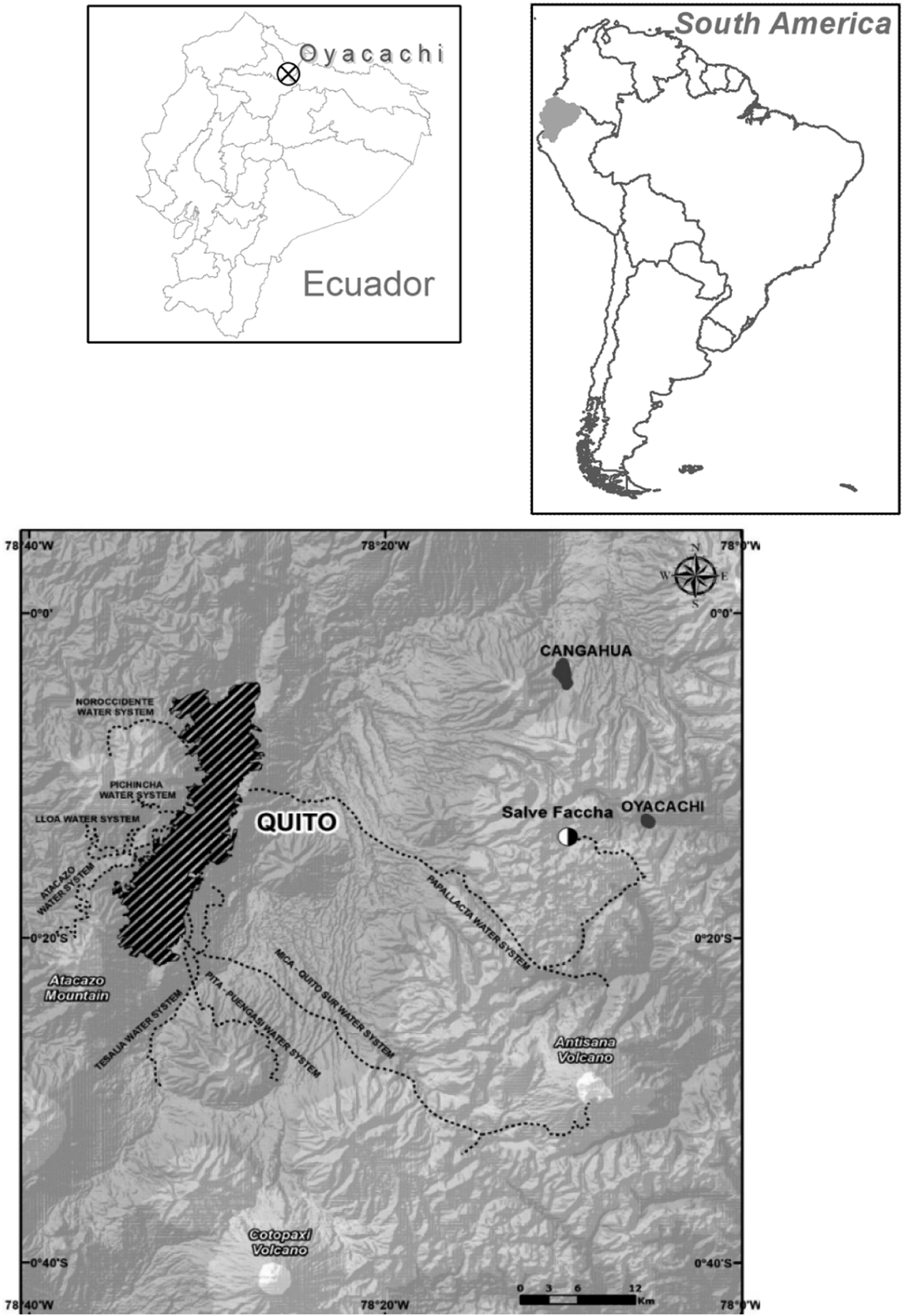
In the next section we outline the theoretical notions that support our analysis. Then we present the history of the Oyacachi páramos and the indigenous community that has lived in and from them for centuries. The fourth section analyzes how social imaginaries of external actors about the Oyacachi páramos changed and how this has prompted the deployment of different interventions. We first analyze the declaration of the páramos as a nature reserve in the 1970s and then the overlapping and, to some extent, complementary hydro-social territorialization of parts of the páramo which enabled distant users (Quito and the Cangahua communities) to access and transfer substantial amounts of water out of the páramos. Then we analyze how the community of Oyacachi has dealt with these interventions through counter-conducts and the creation of new hybrid meanings, relations, and grassroots responses. We conclude by reflecting on the case and the theoretical implications of our analysis.
Disentangling interventions and their negotiation: Territorialization, imaginaries of place and governmentalities
Territorialization and the ordering of socio-natural relations
The notion of territory developed in studies about state formation where territory was conceptualized primarily as a bounded space under the control of a nation state. Departing from these, different scholars have advanced the concept towards a notion that helps to understand how actors, artefacts or other material structures and the environment interact and coproduce each other within specific geographical spaces (e.g., Agnew, 1987; Elden, 2013; Painter, 2010). Though the concept has been broadened, control over socio-natural interrelations in a defined geographical space has remained a central concern to the notion of territory: “politically speaking, territory is the socio-materially constituted and geographically delineated organization and expression of and for the exercise of political power” (Swyngedouw and Boelens, 2018: 117). Territories are created by actors, who in view of a specific purpose claim power to mediate, reconfigure and mold a geographical space and its constitutive resources, ecological/built environment, institutions, and social groups. A territory is therefore constructed only in relation to other actors (Barth, 1969) and their arrangement with ‘the natural’. Hence, processes of territorialization aim to control how space is organized by deciding on the meaning, substance, and interweaving of its biophysical and social elements according to a specific imaginary about this place (e.g., Baletti, 2012; Bridge, 2013; Lefebvre, 1991).
In studies about water and its territorial relations the notion of hydrosocial territories has recently gained strong traction (e.g., Flaminio, 2021; Hommes et al., 2020; Rogers and Wang, 2020; Ross and Chang, 2020; Verzijl et al., 2019). Hydro-social territories were originally defined as “the contested imaginary and socio-environmental materialization of a spatially bound multi-scalar network in which humans, water flows, ecological relations, hydraulic infrastructure, financial means, legal-administrative arrangements, and cultural institutions and practices are interactively defined, aligned, and mobilized through epistemological belief systems, political hierarchies and naturalizing discourses” (Boelens et al., 2016: 2).
In the same special issue Hoogesteger et al. (2016) and Duarte-Abadía and Boelens (2016) point out how territories and their socio-material properties (subjects, objects, boundaries, and relationships) are always contested. Their creation and recreation are often disputed from ‘within’ as well as from ‘the outside’ as diverse actors strategize to shape ‘their’ territory according to ‘their’ notions (Hoogendam, 2019; Van Teijlingen, 2019). For external actors with specific social imaginaries of place, a territory embodies the socio-natural space where a population needs to be governed and steered towards specific outcomes such as nature conservation (Vela-Almeida, 2018). Because actors pursuing a territorialization project depart from their own particular notion, in this case a specific social imaginary of a place, territorialization projects greatly differ in terms of their size, boundaries, contents, strategies, objects, subjects, networks, and ontologies even if they share (parts of) the same geographical space. Hence, multiple/plural territorialization projects arise, interact, compete, coexist, complement, and/or overlap (Boelens et al., 2016; Götz and Middleton, 2020; Hoogesteger et al., 2016). However, to better understand the roots of interventions we turn to the notion of social imaginaries of place and the relation these have with different interventions.
Imaginaries of place, interventions and resistance
While place may be defined as ‘space filled up by people, practices, objects, and representations’ (Gieryn, 2000: 465), it is more than a location with its socio-natural filling. What matters is the significance that it has to humans (Creswell, 2009; Tuan, 1977) and how this relates to the physical and material dimensions of space. Without identification, representation, and naming by individuals or groups, a place is not a place (Altman and Low, 1992). Such is created by the sense of place which gives it symbolic meaning and value (Harvey, 1997). Consequently, we explore place here first and foremost in the imagined (symbolic, narrated, interpreted, understood) sense and secondly, in how this imagined sense relates to the physical/material sense (Gieryn, 2000; Soja, 1996).
To do so we link the notion of place to that of imaginaries. The latter points to the different ways in which meaning and understanding are given to ‘things’; in this case to páramos. As Adams et al. (2015) shows, these meanings facilitate the (re)production and transformation of the relations between and among the social and the natural through specific practices (Castoriadis 2007). As Boelens et al., 2016 pose: “imaginaries can be understood as the socioenvironmental world views and aspirations held by particular [individuals or] social groups, as the wished-for patterning of the material and ecological territorial worlds with and through the corresponding values, symbols, norms, institutions and social relationships” (Boelens et al., 2016: 7). Steger and Paul (2013: 23) explain that “imaginaries are patterned convocations of the social whole” which create parameters within which people give meaning to their existence and their actions. Based on these ideas we conceive of ‘imaginaries of place’ as time-bound notions, perspectives, and aspirations that specific actors have about a place and which give meaning to the actions and interventions that actors plan and implement in a specific space (Hommes et al., 2019). These actions and interventions are closely aligned to understandings of how and what a place and its filling are, were and should become in the future.
For analytical purposes we divide imaginaries of place into dominant (external), that is social imaginaries of place, and alternative or local imaginaries of place (Asara, 2020; Hoogesteger et al., 2023). Social imaginaries of place refer to how external actors such as bureaucrats, politicians, scientists, practitioners and other state and non-state actors give meaning to a place and how they relate to it through amongst others the design and implementation of interventions. These are often based on specific expert systems of knowledges and frames and/or based on extractive and/or conservationist socio-political interest. These social imaginaries of place create a frame for the development of expectations and the underlying normative notions (Taylor, 2004) that inform these interventions. For this, a specific social imaginary of place is created that unites three elements: first, the materiality or nature (the object), second, the social subjects and practices (the subjects), and third, specific relations between these two (the relations) (Mills-Novoa et al., 2020). From this perspective interventions are understood as actions that aim to align these three elements (the object, the subjects, and the relations between these) in a specific ‘order of things’ (Foucault, 2008).
Local imaginaries of place, on their hand, are closely related to lived notions of place by those who ‘experience particular locations with a measure of groundedness; a sense of boundary; connection to everyday life and identity, traversed by power’ (Escobar, 2001: 140). Place-rooted families and collectives “... encounter places, perceive them, and endow them with significance”, they thereby “mobilize political notions of attachment and belonging” (Escobar, 2001: 151, 149). This renders alternatives for ‘acting otherwise’ and negotiating interventions according to their own lived experiences, aspirations, and existing socio-natural relations of reproduction (Haiven and Khasnabish, 2014). Such negotiation of interventions expresses as counter-conducts through which external actors and their projects are resisted, leveraged, and reworked (Mills-Novoa et al., 2022) in the ongoing and contested processes of territorialization. Through contestation, negotiation, and re-definition, imaginaries of place (both social and local) become flexible, rendering these malleable and changing over time (Agnew, 1987; Dukpa et al., 2018; Jorgensen and Stedman, 2006). Therefore, the reframing of territories through interventions also restructures the existing social and local imaginaries of place (Vela-Almeida, 2018).
Intervention governmentalities
Through different governmentalities (or ‘arts of government’, Foucault, 2008) webs of actors constituted by state agents, companies, non-governmental organizations, and others, consciously or not, deploy techniques that align the objects, subjects, and their relations into a specific order (Dean, 2009). Among Foucault’s diverse conceptualizations of governmentality, we elaborate on his territorial characterization: “Government is the right disposition of things, [...] a sort of complex composed of men and things. The things with which in this sense government is to be concerned are in fact men, but men in their relations, their links, their imbrication with those other things which are wealth, resources, means of substance, the territory with its specific qualities, climate, irrigation, fertility, etc.; men in their relation to that other kind of things, customs, habits, ways of acting and thinking, etc.” (Foucault, 1991: 93).
In The Birth of Biopolitics Foucault (2008) distinguished four key ‘arts of government’. Of these, the power modes that we examine here are the sovereign, disciplinary, and neoliberal governmentalities. Sovereign governmentality is enacted by the state through mechanisms such as laws and constitutions (Gordon, 1991; Menga and Swyngedouw, 2018). Non-compliance is often punished through fines, threats, exclusion and, in some extreme cases the use of physical (police/military) force. Disciplinary governmentality uses normalizing power aimed at guiding and molding the subject’s behavior, practices and thinking, creating ‘subjectified subjects’ (Foucault, 1977, 2007). The subject’s behavior then becomes the object of intervention (‘producing subjects’) where the aim is that subjects internalize and align to specific discourses and related self-discipline so as not to be deviant or immoral (Agrawal, 2005; Feindt and Oels, 2005; Foucault, 1977). Finally, neoliberal governmentality uses market mechanisms (often implying monetary transactions) to conduct the conduct of humans who are identified as economic actors. Therefore, neoliberal governmentalities influence the thoughts and actions of populations through economic incentives under the assumption that profit-maximalization shapes the behavior of individuals and collectives (Fletcher, 2010; Dupuits, 2019; Vos and Boelens, 2018). This approach manifests in conservation strategies such as payment for ecosystem services programs (PES) that financially incentivize conservation (Fletcher and Büscher, 2017; Rodríguez de Francisco and Boelens, 2016).
Oyacachi: the páramo of an isolated indigenous community
The páramos studied here are in the eastern foothills of the northern Andes in Ecuador. They have been a place of livelihood and cultural-symbolic values for the indigenous community of Oyacachi for over four centuries. Oyacachi people are descendants of the Kayambi who fled after the massacre of their young men in the Yahuarcocha lake by the conquering Inca empire around 1492 (Andrade Marín, 1952). The first settlement of the community occurred around 1580 in the lower basin of the Oyacachi River (GAD Oyacachi, 2015). However, due to frequent earthquakes the settlement was moved a few times.
The early colonial administration knew Oyacachi existed but few dared crossing páramos "that were like a path to death" because the horse trails where steep, along cliffs, covered with mud and under constant rain (Salazar Medina, 2001). By the 16th century, catholic missionaries had Christianized them. Until the 1990 the community lived in partial isolation from the white-mestizo society and the only contact with the outside world was with the nearby Kayambi indigenous people of Cangahua. The lower area was used for small-plot agriculture (DIVA, 2000). As in other parts of Ecuador, during the beginning of the independent republic (1830s), páramos were not assigned to any owner but considered wastelands. So, communities and big haciendas shared its use mainly for cattle grazing, wood gathering, and hunting (Larrea, 2006). Resources such as grass, wood, and water were free. While for the urban-mestizo people it was only the useless, rough, cold, and cloudy top of the mountains, for the marginal indigenous populations it was a refuge (Recharte and Gearheard, 2001) and a mythical place where all other natural elements are sentient beings that interact with people (Boelens et al., 2012; Ulloa, 2019). Myths and legends are part of the indigenous place making, as the sacred cascade of Salve Faccha (Camacho et al., 1999) that was later affected by the capital city water dam construction. Páramo was an immeasurable place. As one of the old leader remarks: “All the valleys around and all the mountains that we could see from Oyacachi village, all of them are ours” (Indigenous Government President, personal communication, 16 May 2012) There were no set boundaries, it was just the vast páramos.
Today the community is governed under an indigenous council elected in an Assembly. This customary government coexists with the official government system imposed by the mestizo political society, the Parish Board, whose representatives are elected by popular vote. In 1939 the Ecuadorian State declared Oyacachi as a commune and in 1959 as a rural parish, Ecuador’s lowest administrative unit (GAD Oyacachi, 2015). The Oyacachi community comprises around 160 families dedicated to animal husbandry, tourism via its thermal water, trout pools, and the sale of wooden crafts. What the páramos as place are for the community today is quite different than half a century ago, as is analysed below.
The páramos as a place for nature conservation
In the last 50 years the Ecuadorian State has put much effort in the creation of nature reserves with the aim of preserving nature, biodiversity, and environmental services such as hydraulic services, in a context in which internationally attention was given to biodiversity conservation; many ‘inhospitable’ spaces were made into valuable places that needed to be protected and controlled to ensure that their (biodiversity/nature) values were maintained in time and space. The prevailing view was that they should be protected from ‘human’ natural resources use practices and disruptions that would threaten plants, animals, and whole biomes. As is it explained in country´s first protected areas strategy:“In Ecuador, as in the rest of the world, the wild areas that exist have not yet been used by man for agriculture, livestock, forestry, or other uses because it is precisely there that ecological and physical conditions, such as extreme climatic factors, steep slopes, poor soils and inaccessibility that severely limit its potential ... any traditional employment would yield a marginal production that will not contribute to the country´s development”. And one of the main objectives of the protected areas was “to maintain and improve the hydrological systems and the water supply” (Putney et al., 1976). However, some conservationist advocated that national parks could not be conceived without people, (Amend and Amend, 1995) specially in South America. In Ecuador, between the 1970s and 1990s many protected areas were declared that contained páramos that cover ca. 36% of the total ecosystem area (Ortiz, 2003). NGO and the environmental sector talked about the hydraulic capacity of Protected areas, considering them as “water factories” (TNC, 1997).
In 1970, the Cayambe Coca Ecological Reserve, containing the Oyacachi páramo, was created with 28% of its total extension being páramo. At the time of the declaration, about 7000 people lived within this geographic space, including indigenous communities (Oyacachi and the Cofán community of Sinangüé) as well as settlers of poor and landless immigrant populations from other regions of the country (TNC, 1997). As many other communities, Oyacachi suffered the imposition of a protected area over their territory. According to the environmental authority, almost 30% of the Protected Areas National System is over individual or communal property (Himley, 2009). The decree established a series of restrictions on land and natural resources use. The Ecological Reserve category allowed the presence of humans and subsistence activities by indigenous people under certain conditions.
For Oyacachi, at first nothing happened because they did not know about the decree nor of its consequences. Protected areas were declared “on paper” with little state capacity to manage and control. In 1982, a park ranger from the National Forest and Natural Areas Institute arrived for the first time on horseback to inform Oyacachi that they lived in a ‘protected area’ and that this had implications for how they could (not) use the space and its natural resources, and which authorities had power to decide on it. However, in practice little changed as there was no implementation of the existing regulations except for self-regulation, because the community and the páramos remained by-and-large isolated.
The páramos as a place of abundant water resources
“Oyacachi, is a territory that stands out above all for the amount of water that is born in it and runs through it, forming rivers, streams, hot springs, mineral springs and lagoons” (Plan de Ordenamiento Territorial, 2015).
At the end of the 1970s, for governments and other actors the páramos of the Ecuadorian highlands became an imagined place from which they could access water to provide for the growing water needs of cities and agriculture in the inter-mountain valleys. In the Oyacachi páramos, the first water concession applied for was that of 8000 L/s from the Oyacachi River in 1980 by EPMAPS, the Metropolitan Public Water and Sanitation Company of Quito. In the early 1990s the communities of Cangahua applied for the right to use water from Oyacachi páramos and in 1993 the state granted them 500 L/s. In 1995 additional 1093 L/s of water from Oyacachi springs were granted to Cangahua. However, this ruling was appealed by EPMAPS which had a project to obtain water from the same sources, thus starting a struggle and coupled hydrosocial territorialization projects over the Oyacachi páramos.
In 1995 the MAATE (Ministry of Environment, Water and Energetic Transition) authorized the first large infrastructural project in the páramos of Oyacachi by granting EPMAPS permission to construct a road that crossed the páramos to be able to build, operate, and maintain the water infrastructure needed to divert the granted water to Quito. In 1996, the Papallacta 2 project started. It consisted of the Salve Faccha dam with a storage capacity of 12,500,000 m3 and related infrastructure to first divert water from its sources to this dam for storage, as well as the infrastructure needed to transport water from the dam to Quito. This project cost US$12.8 million and construction took about 6 years. Today it provides an average of 1.8 m3/s to Quito. The Salve Faccha dam and part of the other infrastructure was constructed on páramos that the community of Oyacachi considered as theirs.
For Oyacachi this was a tremendous contradiction. On one hand, the environmental authority demanded the community of Oyacachi to comply with the rules for a protected area; on the other, it allowed EPMAPS to transform the place through infrastructure and the derivation of water to Quito. Not only was nature (and related water flows) transformed; the accessibility of the páramos through the road also intensified the social interactions between the community of Oyacachi and external actors. As one of the old community members sentenced “that road and that dam split our territory in two, they fractured it.” (Personal communication, former president and former park ranger, 11 July 2011).
In parallel to the construction of the dam and related infrastructure, in 1997 construction of the hydraulic infrastructure to transfer water for irrigation to the communities of Cangahua started (see also Hoogesteger, 2013). With this infrastructure in place, the implementation of techniques of government aimed at territorializing the páramos intensified. For external actors, Oyacachi was a territory of abundant water, some of this water was not used, so, “there was plenty of water to give to others” (Cangahua leader. Personal communication, 12 November 2010). But for Oyacachi, they were not losing only water, they were losing the right to decide over their territory and their resources, and this was “a damage from which we are not going to recover for a long time " (Oyacachi Indigenous Government President, personal communication, 20 May 2010).
Governmentalities of Territorialization of the páramos
Sovereign governmentalities
The new road enabled the MAATE as well as functionaries of EPMAPS to have more presence in the páramos. EPMAPS started to regulate the access to the Salve Faccha area. It also started to control the grazing in all Oyacachi páramos (specially in upstream catchment of the Salve Faccha Dam) and which they considered as ‘strategic’ for ensuring water provision. As EPMAPS stated “the company has an important policy to conserve the páramos” (Dávila, 2010) and “… This is a joint effort between EPMAPS and the ministry of the environment” (Vega, 2011).
The conservation efforts were further intensified when the category of Ecological Reserve was changed to National Park in 2010. The principal objective of National Parks in Ecuador is “the maintenance of the area in its natural condition, prohibiting any exploitation or occupation “(MAAE, 2006). This legally implied that human presence should be kept at a minimum. Such a protected area can only have sporadic visits from external actors with scientific, educational or recreative purposes. This official notion of what this place should be clashes with the indigenous peoples’ notion who live in this place and use the land for pastures and agricultural plots, hunting and harvesting of wild berries, as well as other traditional uses of natural resources such as alder woodcrafts.
Conflicts and tensions have been constant between Oyacachi and the environmental authority. Trying to find a solution, in 2001 the ministry made an official recognition of the indigenous territory of Oyacachi within the protected area. This recognition is extraordinary for an indigenous community in the Ecuadorian Sierra, and even more, inside a State protected area (FFLA, 2010), as indigenous communities are only recognized as communes under a parish which is an official political subdivision. This happened even though the Forestry and Conservation of Natural Areas and Wildlife Law (Registro Oficial Suplemento 418, 2004) does not allow the constitution of property rights over State areas; therefore, indigenous territories, and peoples, most of the times are left in illegality (MAAE, 2006).
Disciplinary governmentalities
With the opening of the road to Oyacachi many NGOs intervened in the community. It was an ideal place to experiment with development projects that aimed to ‘discipline’ and bring progress the local community. All these projects aligned to develop sustainable livelihood strategies for the community of Oyacachi such as a tourism and other sources of income that did not depend on the intensification of cattle grazing in the páramos as this is seen by NGO and soil scientists (together with the practice of burning the páramo) as the biggest and most immediate threat to this ecosystem (Podwojewski and Poulenard, 2011). Several studies were carried out to see “how much pristine land has been changed to agriculture and livestock grasslands and how traditional natural resources uses were changing because of the presence of external actors” (DIVA, 2000). Another important strategy to conduct-the-conduct of the community members that is recurrent in the interventions of NGOs and state agencies is the implementation of capacity-building and awareness-raising campaigns to create self-correcting individuals that align themselves and their peers with the knowledge, ideas and principles that are ‘taught’ in such programs. NGO under the discourse that “society should be conscious about the environmental services that protected areas provide”, “it should value the hydraulic productivity of these areas” (TNC, 1997). The same applies for the creation of community management plans, training of park rangers and other ‘capacity building’ interventions. All these interventions where part of a strategy “to finish with the last community resistances to the municipal project” (Former employee of Fundación Antisana, personal communication, 17 September 2010).
In line with these strategies the environmental authority contracted Oyacachi people as park rangers. Their responsibilities include looking out for and preventing páramo burning, hunting or cattle grazing from other communities. Thus, Oyacachi people have been made guardians of the National Park paid by EPMAPS and FONAG and aligning their incentives, activities, and identities to the conservationist territorial imaginary of the state and NGOs.
Neoliberal governmentalities
Another strategy that has been used by the State to control land use with the aim to advance conservation purposes in the Oyacachi páramos is the Socio Bosque Program. This program is based on the principles of a Payment for Ecosystem Services scheme in which the state pays an annual monetary compensation fee in exchange for a set of conservation measures that the owners of these lands must fulfil in order to guarantee the provision of a specified ecosystem service (Boelens et al., 2014). Oyacachi entered the Socio Páramo Program in 2015. This is part of the Socio Bosque Program that MAATE began in 2008 with the objective of conserving forests and páramos through economic incentives to individual or collective owners. The condition is that they voluntarily commit to their conservation and protection and to follow-up protocols under a 20-years agreement and with a maximum payment of US $ 30/ha per year. To enter, communities and individuals must have the property title (MAAE, 2020). By accepting the payment of incentives for conservation, they give up their right to use their land and its resources.
1
The Socio Páramo Program in the Oyacachi Indigenous Territory is concentrated in the headwaters or páramo area, not in the valleys. According to official data, the indigenous territory has 62,630 ha, of which approximately 20,000 ha are now under the Socio Páramo agreement (see Figure 2). The plurality of territories over the same space.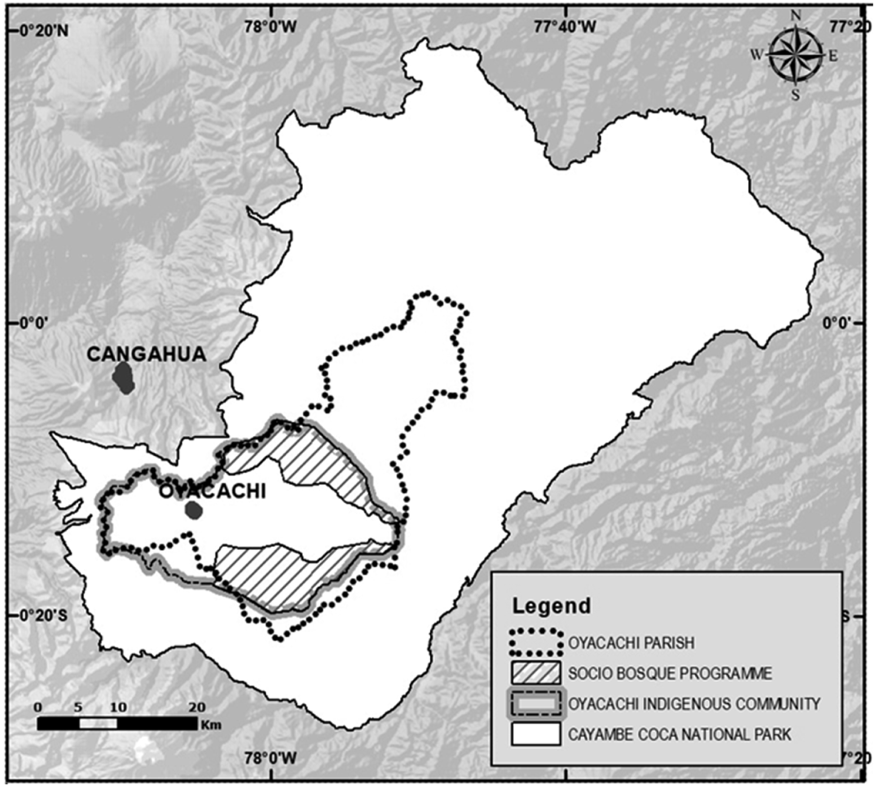
Another external territorialization strategy is led by the water company. In 2001, after the community block the road and prevented the machinery from entering, the company accepted that the construction site belonged to Oyacachi and agreed on a first payment of US$ 65.000 dollars and an annual payment for the next 47 years. Community leaders’ arguments were “if the company is benefiting from this water, the community should receive something, some payment or compensation” (Oyacachi Community President, personal communication, 13 April 2010).
To conserve the páramos as the supply areas for the city of Quito and thus "guarantee water in quality and quantity" EPMAPS created, together with other public and private institutions, the “Fondo para la Protección del Agua” (FONAG) (FONAG, 2018). In order to achieve this objective, sometimes they purchase land, and do surveillance and control actions on “unscrupulous people who will affect the rivers or water sources by hunting, fishing, burning and garbage, the protection of water sources to avoid the trampling of livestock and the erosion of slopes, the economic and physical assessment of the water productivity of these areas, as well as introducing good agricultural practices in the areas dedicated to production ”(TNC, 1997).
In Oyacachi, one of the main objectives of FONAG has been to change livestock activity by supporting other activities such as tourism in hot springs, making alder wood handicrafts, fish farming and small-scale agriculture. “They (FONAG) have also given US $ 500,000 for agricultural projects. This is so that the cattle of the 3 sectors from where the water comes out are lowered as they move forward. […] The Oyacachi Commune must fulfil its commitment to livestock reconversion and definitively abandon its pressure on the ecosystems of the micro-basin of the Cununyacu River of the Salve Faccha Dam and Mogotes Dam” (Terms of Reference of the Development and Territorial Ordering Plan Contract 2010).
Counter-governmentalities and the negotiation of territory
Oyacachi has not passively accepted the strategies of government that have been rolled out onto them by the state and NGOs. As we analyse here, the community has steadfastly advanced and re-created its own local imaginary of place and its related strategies to (counter)territorialize it. One of the first steps to advance their own territorial strategies was to claim the Oyacachi páramos as their historical indigenous lands/territory. In 2001 the community of Oyacachi was recognized as ‘owner’ of it. This territory comprised over 62,000 hectares many of which are páramos in the headwater of the rivers and springs that feed Salve Faccha and the Cangahua irrigation system; all is within the now National Park Cayambe-Coca (Figure 2). This declaration of indigenous territory with fixed spatial boundaries gave the community a very strong negotiation position. The dam, the access road, and the hydraulic infrastructure were built inside the boundaries of the indigenous territory of the community of Oyacachi. As such, the community considered that the water company was meddling in their land. The EPMAPS alleged that the dam was outside the indigenous territory, and that they had all the papers and permits in rule, including the environmental license from the environmental authority.
To open up negotiations, in the late 1990s the Oyacachi community blocked the access road to the building site of the dam. This forced EPMAPS to sit down to negotiate. The community’s claims included that Oyacachi should have been the one to give permission for the construction of the dam and for taking water from its territory. It demanded an apology and compensation for the damaged caused. In 2001, EPMAPS and Oyacachi arrived at a legal agreement that included an initial payment of US$ 65,474 and annual payments of US$ 6044 for the first year and US$ 9669 for the next 47 years until 2049 (Rodríguez, 2008). This money has been useful for the community, as one of its leaders stated: “With the first payment… the community… bought a bus [that now runs on a daily basis between Cayambe and Oyacachi] and solved the transportation problem…” (personal communication, 9 January 2010). Since then, Oyacachi has used its territory as a bargaining chip, and EPMAPS and FONAG have promised to provide all the services such as drinking water, sewerage, and paving the main streets of the village; ---- that an absent State has not provided. But EPMAPS compliance to the agreements has been partial, as one of its inhabitants complains: “The only thing that has recently been agreed with the Parish Board is the sewerage... They said that in 2 months it will be done. The Manager committed himself to finance drinking water and sewerage”. (personal communication, 1 June 2011).
Having an Indigenous Territory inside the National Park is a problem for the environmental bureaucrats. Thus, the Oyacachi territory is considered a “critical area” for which a “special community land management program” has been proposed within the Protected Area Management Plan (MAAE, 2009) which is a sovereign governmentality State instrument under which the community will keep its territorial rights but with specific resources and land use limitations. According to the Organic Environmental Code, article 37: “In protected areas, limitations of use and enjoyment of the properties that exist in them and other real rights that are necessary to ensure compliance with their conservation objectives must be established. The State will evaluate, in each case, the need to impose other limitations” (Registro Oficial 983, 2017).
Oyacachi understands that their land is now within a protected area and that the environmental authority can take decisions over it; however, they also perceive it as their territory and home where their productive and subsistence activities take place. Therefore, even though according to the MAATE grazing pressure must be kept low, the community has increased its livestock. This led to conflicts with wildlife, specifically the spectacled Andean bear. The community, faced with the loss of their cattle, have threatened the Ministry and the conservationist NGOs with killing bears (Espinosa and Jacobson, 2012). But if they do so, this could lead to sanctions as when someone sets fire on the páramos area to get greener pastures. In the Art. 246 of the Organic Integral Penal Code “the person who directly or indirectly causes fires or instigates the commission of such acts, in native or planted forests, will be sanctioned with imprisonment of one to 3 years” (Registro Oficial 180, 2014). However, the National Environmental Authority has not taken any actions upon these incidents yet. In these circumstances, Oyacachi follows the decisions made by its own indigenous government even though sometimes they contradict the ones from the environmental authority. They must negotiate and sometimes they do things even knowing that they are prohibited in a protected area.
Despite all the external efforts to control cattle expansion and create alternative strategies, livestock activity has expanded since the construction of the road and Oyacachi became a dairy producer. The hectares for grazing increased from 330 ha in 2000 to more than 730 ha in 2015. Livestock and dairy production became the main source of income for 95% of the families (GAD Oyacachi, 2015). To enable this, they continued pushing the agricultural and livestock frontier towards the lower area, in the foothills of the mountain range where there was not much enforcement. Clashes come and go; negotiations often smoothen the contradictions, temporarily or not. The environmental authority and the water company have established several restrictions not only around the dam páramo, where they have guards, but also within all the territory. Nowadays, the Oyacachi people have withdrawn their cattle from the páramo areas. However, they maintain their herds close to the town and on the pastures of the lower basin, so there are less possibilities of an encounter between bears and cattle. Also, NGOs have promoted upgraded husbandry in a concentrated area while improving pastures and other dairy practices. The community has also increased tourism activities related to hot springs and trout fishing.
Malleability and hybridization of imaginaries of place
Today, Oyacachi is imagined as a hybrid and malleable place in which plural notions about that ‘place’ come together to shape new territorial configurations. For environmentalists (NGOs and the State) the Oyacachi páramos have become a place not only of nature conservation, but also a place that must be continually re-created through interventions and negotiations with the community. To materialize an imagined place for nature conservation several sovereign, disciplinary, and more recently, neoliberal governmentalities have been used to guide the conduct of the individuals and the collective of the Oyacachi community. State regulations for conservation have been created and sharpened and the status of the natural reserve was changed to National Park to have greater control and regulation on what is or not allowed in this territory of conservation. Park rangers have been appointed, most of which come from the community itself with the aim of implementing sovereign governmentalities. Together with several NGOs, over the past 30 years many interventions that aim to discipline and self-correct the behavior of the Oyacachi community have been implemented. These ranged from capacity building, awareness raising and environmental education programs to the participative development of zoning and land use plans, to the development of ‘alternative’ livelihood strategies (tourism, trout production, artisanship, intensive dairy production) to reduce the pressure on the use of páramos. Finally, the Socio Páramo Program as a neoliberal governmentality limits the use of parts of the indigenous territory.
For EPMAPS these páramos have become a very important source of water for the growing demands of Quito. At the same time, it has become a place where they must govern (and negotiate with) the community to protect the water sources. To do this EPMAPS has directly negotiated with them how to convert water into a commodity apt for compensation payment (neoliberal governmentality) while at the same time aligning the actions of FONAG and other NGOs to the conservation of the headwaters. The deployment of these strategies has gone together with a constant negotiation with the community that considers that EPMAPS has intruded their territory.
Oyacachi has continuously struggled to defend the indigenous territory and the use of it. In this sense the páramos that were originally considered sacred, immeasurable places have become places of contestation where the community has to defend and negotiate their natural resource use and practices. Simultaneously, it became a space prized by outsiders for specific purposes and resources and from which financial resources, projects, and support for the community can be arranged and negotiated. Through counter-conducts, protests, and negotiation with external actors, the community has managed to acquire jobs, investments, and alternative sources for livelihood and income. For the community, it has also become a place in which its abundant water resources are contested and for which they have taken up a notion of care for both nature and water.
As a result, imaginaries of place related to the Oyacachi páramos have shifted and changed for all actors. Meanings and values have changed and hybridized, spatial boundaries have been drawn and contested, new economic activities have been developed, infrastructure has been built, water is continually being transferred to the city and irrigation systems, and new social and socio-natural relations have developed. Likewise, Oyacachi’s indigenous identity, which throughout history always has been a dynamic and changing mode of identification with the territory, has been subject to accelerated strategic adaptations that enables creative answers to new local-global market, government, and commons forces. Consequently, new socio-natural relations have been created and new and evolving processes of territorialization are continually reshaping the relations between and among the social and the material elements in these páramos.
Conclusions
Understanding territorialization by either state or non-state actors is important because it repeatedly leads to local contestations where actors strategize to articulate the territory differently (Asher and Ojeda, 2009). To better understand such territorialization efforts we have developed and applied the notion of imaginaries of place which we divided into social imaginaries of place and local imaginaries of place. The former informs intervention strategies and their related governmentalities. The latter forms the basis upon which local communities negotiate interventions through counter-conducts of resistance, leveraging and/or reworking. As we showed, the páramos of Oyacachi are socially imagined as a place of pristine nature in need of conservation and as a place with abundant water resources that likewise needed to be protected to be able to transfer clean and abundant water to the city and agriculture. The local imaginary of páramos as a place was originally based on notions of a sacred place that was used for hunting and grazing for centuries; though these notions have been evolving alongside the social imaginaries of place that have informed and been advanced through intervention projects. As such, the imaginaries of the Oyacachi páramos have shown to be hybrid and malleable. At the same time both social and local imaginaries of place have had consequences on the socio-material and symbolic territorialization processes of this space. As such the páramos of Oyacachi got boundaries for being officially recognized as indigenous territory, it became a source of financial resources for the community of Oyacachi, but also a space in which hunting, cattle and other agricultural activities are severely restricted as a means to protect water and nature. As such imaginaries of place perform as a political arena with socio-material consequences in hydro-social territories (Escobar, 2001; Hoogesteger et al., 2016) and other political ecologies arenas (Boelens et al., 2022).
Conceptually we complement existing studies on environmental governmentalities and hydrosocial territories through the development and use of the notion of (social and local) imaginaries of place. It is a concept that allows to better understand the basis that informs the development of different strategies of government and the counter-conducts that emerge as a response to the former. At the same time the notion of imaginaries of place can be explored and expanded through the investigation of how social imaginaries of place are created and develop within specific networks of actors, expert knowledge systems, discourses, narratives but also political interests and power play in these processes (Singh, 2013). Likewise there is much room to explore how local imaginaries of place come to be, based on practices, local belief systems, symbolism, religion and identities.
Practically the notion of social imaginaries of place create openings through which practitioners, policy makes, politicians and bureaucrats can critically explore the very notions that inform their actions, decisions, and interventions. An analysis that can lead to new and creative ways to re-think interventions and how these deal with objects, subjects, and their relations.
Footnotes
Declaration of conflicting interests
The author(s) declared no potential conflicts of interest with respect to the research, authorship, and/or publication of this article.
Funding
The author(s) disclosed receipt of the following financial support for the research, authorship, and/or publication of this article: This work was supported by the Nederlandse Organisatie voor Wetenschappelijk Onderzoek; 01.65.308.00.
Note
![]()