
Abstract
This paper draws upon quantitative data collected from one of the principal associations fighting Islamophobia in France along with the population census, and provides a step forward in understanding the operation and distribution of Islamophobia. It presents a geography of Islamophobia in Paris based on statistical data, and aims to observe whether or not this geography corresponds or contrasts with geographies of inequality (such as those associated with gentrification, deprivation and marginalisation), by analysing the various spatial patterns stemming from the maps. This socio-spatial analysis of anti-Muslim discrimination is important in Paris because since the terrorist attacks in 2015, anti-Muslim sentiment has increased sharply. The mapping of Islamophobia and its association with the spatial distribution of different socioeconomic and demographic variables synthetized in a typological map display significant forms, relations and diversities within Paris. This cartographic analysis demonstrates that the geography of Islamophobia does not necessarily refer to spaces where ‘Muslims’ and the victims of Islamophobia live in great majority, and rather refers to more privileged and central areas such as Paris intra-muros. Victims mostly experience anti-Muslim incidents outside their everyday spaces away from their homes, such as public institutions and workplaces. Indeed, the findings raise the significance of the exact place where incidents occur as well as societal attitudes to these ‘hierarchical’ places where the perpetrator probably feels more comfortable in behaving in an antisocial and sometimes violent way.
Introduction
The spatial distribution of anti-Muslim acts is not random; it highlights important dynamics of separation. Separation of different people and spaces has led to visible inequality in access to employment, education, housing quality and social and territorial integration (Friedrichs et al., 2003; Gale, 2013; Jargowsky, 1996; Wilson, 1987). It also has an impact on different forms of discrimination (Jackson, 1987; Musterd and Ostendorf, 2005; Wacquant, 1993), and this paper seeks to demonstrate the impact of religious discrimination such as Islamophobia. Geographical tensions and dysfunctions can be observed especially by mapping where all Islamophobic acts take place. The geography of Islamophobia in Paris can describe a spatial organisation that generates contrasting areas (such as the centre versus the suburbs, or privileged areas versus deprived enclaves, etc.) (Najib, 2019; Najib and Hopkins, 2020), and the linking between this geography and the socioeconomic and demographic structure of Paris allows us to better observe and understand whether the geography of Islamophobia corresponds with the geography of inequality (poverty, marginalisation, etc.) or not. Earlier geographical studies on Muslims emerged firstly from studies on race and racism (Hopkins, 2020), and tended to focus on the racialization (Kobayashi and Peake, 2000) and identification (Dwyer, 1999) of Muslims, as well as on their urban exclusion and residential segregation (Falah and Nagel, 2005; Gale, 2013; Peach, 2006; Phillips, 2006) connected with geographies of Islam (Gale, 2007; Najib and Finlay, 2020). Geographers have already shown that the spatial distribution of Muslim populations and places of worship correspond to the geography of relative material deprivation notably in London and Birmingham (Gale, 2013; Peach, 2006). Experiences of Islamophobia have been documented in different contexts such as public spaces (Listerborn, 2015), workplace (Ghumman et al., 2013) or airports (Bennett and Phillips, 2006). However, there have been few attempts to map the geography of Islamophobia such as through statistical data collected and recorded by the main associations fighting against Islamophobia. We can use this to observe whether it corresponds to another specific geography or not. Only a few geographers have examined and mapped the perception of Islamophobia and racism; they have compared the geographies of Islamophobia and racism perceived by young Muslims living in Sydney (Forrest and Dunn, 2007; Itaoui, 2016) and in San Francisco (Itaoui, 2019). However, several papers have highlighted the importance of the socio-spatial context as well as the significance of the coexistence of different social groups in the study of specific racist behaviours (Bowyer, 2009; Forrest and Dunn, 2010; Keith, 2005; Letki, 2008). As Muslims have become an increasingly racialized group especially since 9/11 (Allen, 2010; Meer and Modood, 2010; Noble and Poynting, 2010), the study of Islamophobia within specific areas appears more and more relevant.
Islamophobia is a relatively new concept and field of inquiry within the discipline of Geography (Najib and Teeple Hopkins, 2020). The most used definition highlights that Islamophobia appears as a racialization/othering process of individuals that essentialises a group of highly diverse individuals under one single religious attribute, and constructs thinking about Muslims and Islam as Other (Allen, 2010; Naber, 2008; Sayyid and Vakil, 2010). The Runnymede Trust (2017) has highlighted the extent to which Islamophobia remains a serious concern among Muslims when it comes to inequality and discrimination that has a direct affect on people’s lives. The existing definitions mostly highlight that Islamophobia is rooted in racism and in an inequal system, but arguably, they seem too centred on the critical treatments of racism, and the geographical component is not clearly theorized or explored empirically (Najib and Teeple Hopkins, 2020).
In this sense, this paper explores the socio-spatial dimensions of this form of racism. Islamophobia does not function in the same way from one space to another, and this paper considers the different socio-spatial scales through which Islamophobia works. It examines quantitative data on its geographies that capture the nature of inequality, racism and exclusion in Paris. In the French context, the link between geographies of Islamophobia and inequality is analysed without measuring racial and religious segregation. Rather, socio-spatial diversity is explored using socioeconomic and demographic variables, because data on race and religion are not available in France (Musterd and de Winter, 1998; Tovar, 2011), unlike in other Anglo-Saxon countries where the study of racial and religious segregation has already led to important findings, especially when research is about Muslims and Islam (Gale, 2013; Peach, 1996, 2006; Phillips, 2006). That said, some research has already shown that the racialization of Islamophobia in France is connected with the colonial exploitation enacted by France (Hancock, 2009), especially when considering the ethnic profile of the main victims of Islamophobia in France who are mostly from North-African ethnic backgrounds (Najib, 2019; Najib and Hopkins, 2020). Moreover, there is also research that shows the ethnic profile of the perpetrators in order to analyse and understand the explanatory factors of anti-Muslim acts (Copsey et al., 2013) or racist acts in general (Dunn et al., 2004). But there is a need to analyse the social profiles of the geographical spaces where such Islamophobic hate crimes have occurred.
Finally, this paper provides a step forward in understanding the operation and distribution of Islamophobia for several reasons. First, mapping Islamophobia provides a vantage point into the ways in which Muslim populations negotiate Islamophobia and can therefore bring an important contribution to the issue of Islamophobia, which was primarily explored by sociologists, anthropologists, and political scientists (Allen, 2010; Fernando, 2014; Sayyid and Vakil, 2010; Scott, 2007). Second, the quantitative reading of Islamophobia is also a new contribution to the social scientific literature as most studies are primarily qualitative (Dunn, 2005; Dwyer, 1999; Githens-Mazer and Lambert, 2010; Hancock, 2017; Hopkins, 2016; Najib and Hopkins, 2020; Mansson McGinty et al., 2013; Zempi and Chakraborti, 2015). Quantitative research can have an important political and public impact because it can bring attention to alarming statistics. Third, research on geographies of Islamophobia in France and in Paris remains less extensive (Hancock, 2015, 2017; Najib, 2019; Najib and Hopkins, 2019, 2020) as well as challenging compared to other contexts such as UK, since religious and racial categories are not clearly recognized in France. Therefore, for all these various reasons, this paper brings new material to understandings of Islamophobia and Muslims’ exclusion at a global, national and urban scales, and in particular, in the French and Parisian context.
Context of the study and methods
This paper draws upon a research project about Spaces of Anti-Muslim Acts (SAMA) in the Greater Paris and Greater London regions that aims to analyse the spaces where anti-Muslim acts have occurred. The spatial location of Islamophobia in Greater Paris required the collection of georeferenced data on anti-Muslim acts from the database of the CCIF (Collective against Islamophobia in France, Collectif Contre l’Islamophobie en France) which has, at the individual scale, a rich database because it considers all statements (after a verification of conforming material elements), unlike the data provided by the Ministry of Interior which is difficult to collect and only considers acts that conclude with formal complaints. Data are from 2015 (the most recent data available at the time of the investigation) which represents the year that records the greatest number of anti-Muslim acts as a result of the numerous terrorist attacks (the Charlie Hebdo attacks and the 13th November Paris attacks) and their direct consequences on French Muslims. Indeed, the CCIF had to face, in the context of a state of emergency, a high rate of anti-Muslim acts in 2015 with a total of 905 acts 1 (CCIF, 2016), the highest rate in the CCIF’s existence. The 2015 acts are therefore more numerous than usual; which may be (unfortunately) more advantageous for studying them statistically and cartographically. Anti-Muslim acts are defined by the CCIF as all acts of discrimination or violence against individuals or institutions because of their real or presumed belonging to Islam, based on direct reports from victims. These acts include discrimination, discourse, physical assault, verbal abuse, degradation and profanation. In France, the majority of Islamophobic acts are discrimination (65%), unlike in other countries such as the UK where Islamophobia is rather illustrated by verbal abuse (Najib and Hopkins, 2020).
This paper demonstrates the relationship between the spatial distribution of Islamophobic acts and socio-spatial inequalities. The main idea is to observe whether or not the geography of Islamophobia corresponds or contrasts with geographies of inequality, segregation, gentrification and exclusion. This research hypothesis is analysed in this paper, and revolves around many questions based on the previous literature. For example, we know that Muslim populations in France represent one of the most stigmatised and marginalised minority groups (Hancock, 2015; Najib, 2019; Najib and Hopkins, 2020; Scott, 2007). Therefore, Muslim geographies may correspond with geographies of deprivation and poverty (Laurence and Vaïsse, 2007; Simon and Tiberj, 2013; Vieillard-Baron, 2004). But what about the location of anti-Muslim acts? Do they also take place in areas of deprivation where Muslim populations probably live in great majority; or do they instead take place in privileged areas where Muslims may reside less frequently; or do they not depict any relevant geographical relationship (socioeconomic, demographic, etc.)? The answers to these questions will bring significant insights to the functioning of Islamophobia and its link with zones of contact and encounter with either a majority or a minority of Muslims.
Social groups are distributed across space according to various factors (such as the urban heritage and functions of the cities, the political actions, and the residential behaviours of the residents), and spatial analysis can provide important information on the construction or maintenance of socio-spatial segregations (Najib, 2020). There already exists an extensive literature on the spatial patterns of segregation, exclusion and racism, mainly based on one indicator of inequality such as economic conditions (Jargowsky, 1996; Voas and Williamson, 2000), social classes (Massey and Denton, 1993; Wilson, 1987), ethnicity (Jones and McEvoy, 1979; Lee, 1978; Peach, 1996; Taeuber and Taeuber, 1965), or even religion (Gale, 2013; Peach, 2006; Phillips, 2006). The existing studies lead me to mobilize a series of indicators rather than focusing on one in particular. In this paper, I take into account several criteria simultaneously (socioeconomic, demographic, citizenship, etc.) and mobilize a descriptive and synthetic approach using maps to measure the degree of connection between the map presenting the spaces of Islamophobia and the map exposing the socio-spatial divisions of Greater Paris.
To do this, a first series of maps 2 describing the socioeconomic and demographic structure of Paris are provided by using data from the population census and from household taxation in 2012 (respectively from INSEE and DGFIP 3 ). Then, a synthetic map, produced through a factorial and typological analysis, presents the general socio-spatial profile of the different spaces comprising the studied area. As Figure 1 shows, Greater Paris includes i) the city of Paris (with its 20 boroughs or arrondissements), known as Paris intra-muros; ii) the inner suburbs of Paris (known as ‘proche banlieue’ 4 ) which comprises the three departments of Hauts-de-Seine, Seine-Saint-Denis and Val-de-Marne. Greater Paris covers 814 km2 and its population totals over 5.5 million inhabitants according to the 2013 population census.
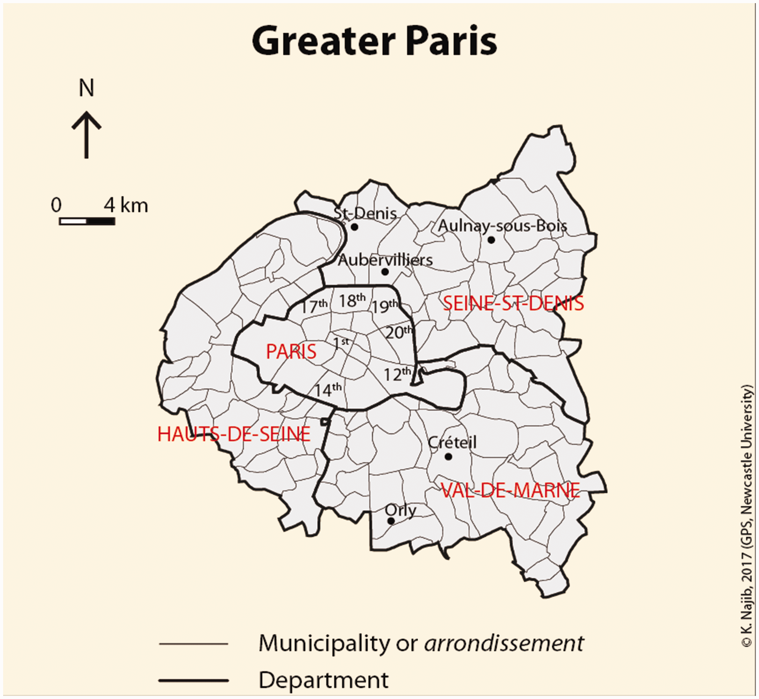
Location map of Greater Paris.
Spaces of Islamophobia in Greater Paris
According to CCIF data, the Parisian region (more exactly the Île-de-France region) is depicted as the most affected region of France with a high rate of 43% of anti-Muslim acts (Najib and Hopkins, 2020). However, it is important here to bear in mind that this probably results from the fact that the CCIF is better known and more active in the capital city than in the other French regions, making it easier for the victims to report their experiences of oppression. That said, in this article, only Greater Paris is considered and not the whole Île-de-France region because the selection of the data from the CCIF database was manually onerous.
Greater Paris recorded 229 acts in 2015, and among these acts, 35% took place in Paris intra-muros, compared to 22% for the department of Seine-Saint-Denis, 20% for Val-de-Marne and 18% for Hauts-de-Seine (CCIF, 2016). Central Paris is therefore the department most affected by anti-Muslim acts. Previous research has shown a specific geography of Islamophobia in Paris providing a map highlighting a centre-periphery urban model contrasting the Parisian centre with its suburbs (the ‘banlieues’) (Najib, 2019; Najib and Hopkins, 2020). The mapping of the raw data using graduated zoning method visually shows in map A of Figure 2 that the Parisian centre is more affected than other areas. Indeed, all the boroughs (or arrondissements) of Paris intra-muros are affected, to different degrees, by the phenomenon. Map A and the corresponding urban model show not only a relevant difference between the centre and the suburbs, but also important focal points corresponding to the municipalities of Saint-Denis, Aubervilliers, and Aulnay-sous-Bois located in the northeast of Paris and the municipalities of Creteil and Orly in the south of Paris (Figure 1).
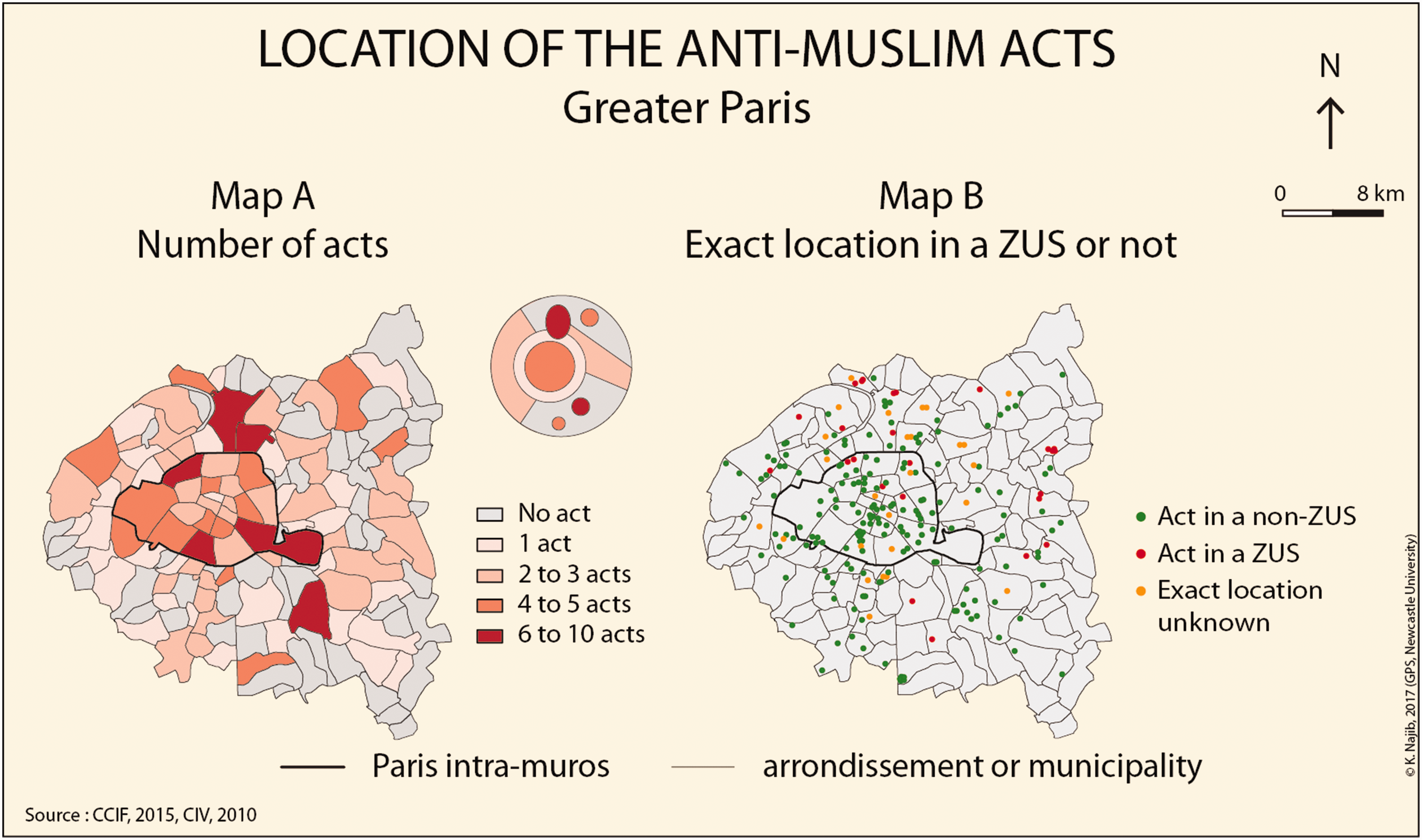
Location of anti-Muslim acts in Greater Paris.
In addition, map B in Figure 2 exposes the mapping of the geographical location where anti-Muslim acts occurred. This shows that anti-Muslim acts do not necessarily take place in working-class and more ethnically diverse districts or in districts classified by French urban policy in the early 1980s as “troubled urban areas” (Zones Urbaines Sensibles). 5 Indeed, there are more green points (i.e. acts located in a non-ZUS) in map B than red points (i.e. acts located in a ZUS). That said, some red points are nevertheless visible in districts of the Politique de la Ville 6 notably located in certain arrondissements of Paris, and in the municipalities of Saint-Denis, Clichy-sous-Bois, Neuilly-sur-Marne, Villetaneuse, etc. (Figure 1).
In the ZUS, there is an aggregation of factors of poverty (unemployment, social housing, low income, etc.) and a high concentration of foreigners (Pan Ké Shon, 2007; Selod, 2005). Pan Ké Shon (2007) explains that the proportion of non-European foreigners has increased in ZUS and that foreigners from African countries as well as their children are three times more likely to settle in ZUS than elsewhere. Further studies have also shown that in France, immigrants from Africa (North and Sub-Saharan) and Turkey have much higher segregation levels than other immigrant groups (Preteceille, 2009; Safi, 2009) as well as a higher risk of cumulative spatial disadvantage (McAvay and Safi, 2018). Muslim populations in France generally refer to working class, disadvantaged families and immigration from North Africa, sub-Saharan Africa and Turkey (Laurence and Vaïsse, 2007; Simon and Tiberj, 2013). These studies indirectly show the great probability that many Muslims live in French ZUS. Consequently, it can be assumed that anti-Muslim acts do not necessarily take place in ZUS where the Muslim populations may live in great majority (Najib, 2019). This observation concerning the residential situation of Muslim populations in France is valid, but must nevertheless be considered with caution due to the unavailability of ethnic and religious data.
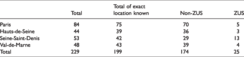
Table 1 shows that the great majority of anti-Muslim acts do not occur in a ZUS. Only 25 acts (out of 229) happened in a ZUS in 2015, that is to say only 11% of all anti-Muslim acts, while the Parisian region includes the largest number of ZUS in France and the population living in a ZUS in Greater Paris is only 11% according to the 2006 population census (Chevalier, 2010). There is a significant number of incidents in ZUS of the Seine-Saint-Denis department. Indeed, among the 53 anti-Muslim acts located in this department, more than 24% are located in a ZUS. But, this department includes the highest number of ZUS in the whole of France (CIV, 2010), as well as a large number of Muslim populations and places of worship (Vieillard-Baron, 2004). This information shows that Islamophobic acts can happen in spaces of poverty and degradation, but the majority do not. The majority of anti-Muslim acts are therefore observed in areas not classified by the Politique de la Ville. Finally, the spatial distribution of anti-Muslim acts already demonstrates important inequalities because they can happen not only in prestigious spaces such as the Parisian centre, but also to a lesser extent in troubled areas. To verify this specific social geography, the next section discusses the spatial distribution of the different social groups living in Greater Paris in more depth, in order to observe whether there is a specific link with spaces of Islamophobia or not.
Distribution of Islamophobic acts in (a ZUS or non-ZUS) of the four studied departments.
Spaces of social inequality in Greater Paris
In this section, a series of maps depicts the spatial distribution of the different social groups in Greater Paris. The French capital city represents prime material for testing socio-spatial inequality in France. Paris is the study area of several research projects revolving around the issue of inequality. Research on gentrification (Clerval, 2016), gated communities (Charmes, 2004; Le Goix, 2006), upper classes and elitism (Pinçon and Pinçon-Charlot, 2014) or deprived and troubled urban areas (Chignier-Riboulon, 2010; Wacquant, 1993) are primarily based on the Parisian region. Also, research on territorial and religious discrimination such as Islamophobia (Hancock, 2015, 2017; Najib, 2019, Najib and Hopkins, 2020) primarily focuses on Paris.
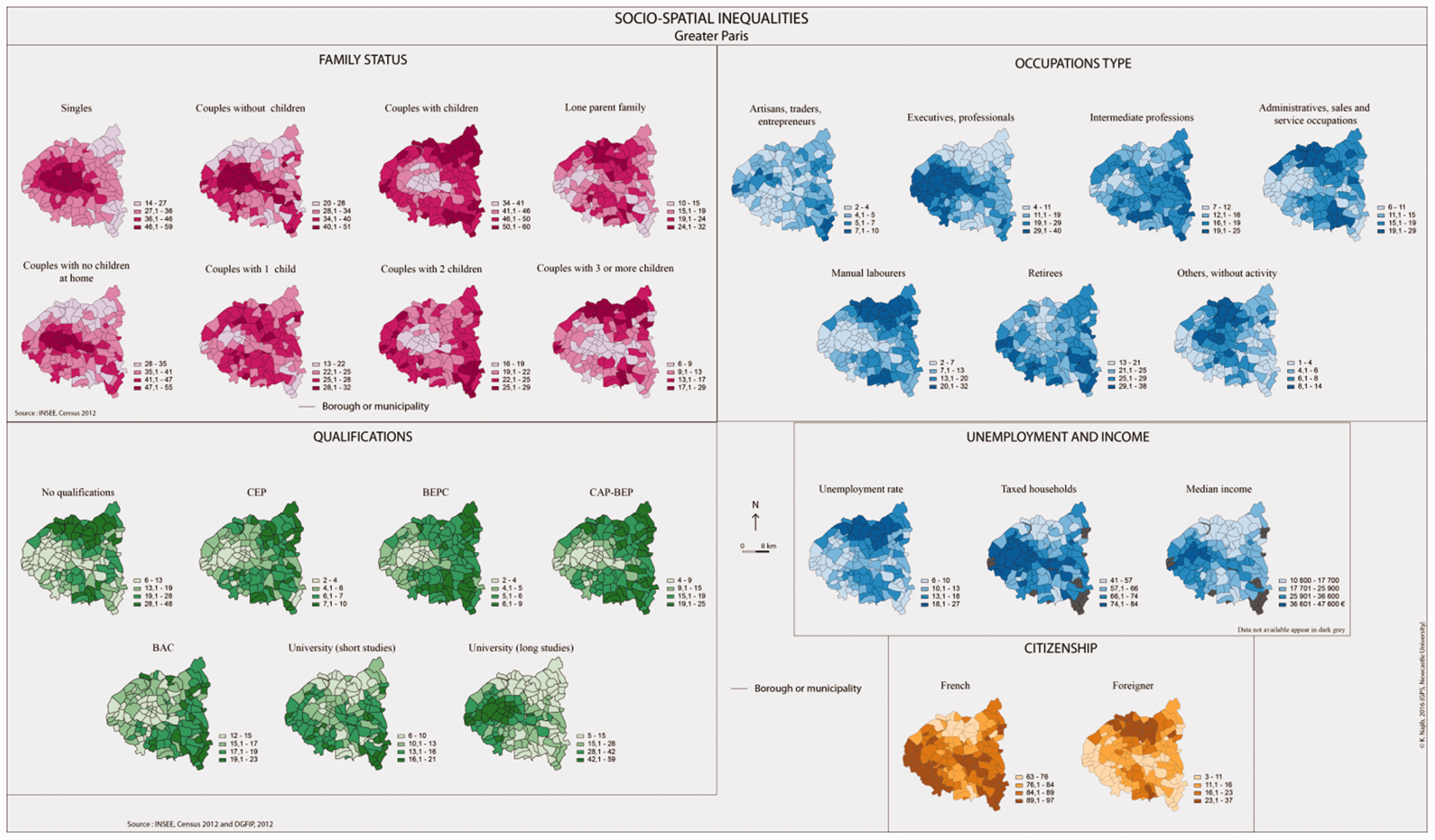
The social geography of Greater Paris is well-documented showing the spatial distribution of different social groups. The Parisian model presents specific spatial dynamics caused by contrasts between different areas due to the social status of their residents. For example, the diffusion of gentrification in some districts of Central Paris results from social groups characterized by a strong cultural capital (Clerval, 2016). However, the mechanisms leading the Parisian bourgeoisie to absolute social isolation in the western part of Greater Paris are less spatialized than in most American suburbs (Pinçon and Pinçon-Charlot, 2014). This Parisian bourgeoisie distances itself from the rest of society, and the upper-middle class can do the same and distance itself from the poorest areas especially when they are associated with an important foreign population. As a result, these areas such as the area of Seine-Saint-Denis in the northeast of Greater Paris become increasingly marginalized and stigmatized, just like their inhabitants (Wacquant, 1993). However, the majority of these existing studies focus only on one type of social class and rarely produce spatial analysis maps; this is why a first cartographic description of various criteria is provided below, referring to citizenship, family status, socio-occupational category, qualification, unemployment and income. This spatial analysis details the general configuration of Greater Paris and emphasizes the strong divisions or associations between different spaces and people already detailed above. Indeed, the series of multi-thematic maps presented in one single figure below (Figure 3) highlights not only important correlations between the selected variables, but also the significance of specific spaces such as the centre, the suburbs or pockets of segregation.
Series of maps on the socio-spatial inequalities in Greater Paris.
Citizenship
As explained earlier, here, I cannot present a more in-depth ethnic and racial analysis due to the lack of official statistical data on ethnicity and race in France. That is why I have used data on citizenship in order to show the residential distribution of French citizens and non-French citizens. The corresponding maps in Figure 3 show a clear division between spaces where French people and non-French people live. In the northeast in the department of Seine-Saint-Denis, there is a significant proportion of foreigners and a low proportion of French citizens. Conversely, in the west and south in the departments of Hauts-de-Seine and Val-de-Marne, there is a high proportion of French citizens and a low proportion of foreigners. These two areas are strongly contrasting: spaces in dark brown where there is a high proportion of French people contrast with spaces where foreigners live in great majority, and vice versa. Spaces in pale beige where foreigners do not live in great majority correspond to spaces in dark brown where mostly French people live. Overall, the mapping of this citizenship variable also demonstrates a relative North/South asymmetry.
Family status
The corresponding maps in Figure 3 show a spatial division between the centre and the periphery. Singles and couples without children or with no children at home (which can refer to young people and older people with adult children) are the majority of residents in the centre, while in the suburbs there are more families with children. Large families and lone parent families are particularly prevalent in the department of Seine-Saint-Denis.
Socio-occupational category, qualification, unemployment and income
The corresponding maps in Figure 3 depict the spatial distribution of different socioeconomic groups and show that the Parisian centre and the west of Greater Paris form a privileged zone where high taxed households are located as well as executives and professionals. This zone contrasts with the rest of Greater Paris and especially the northeastern area where there is a much higher proportion of unemployed people, manual labourers, and people who work in service occupations. There is a clear division between the west of Greater Paris including the Parisian centre, and the northeast of Greater Paris. This division correlates with the maps depicting the qualifications 7 of people aged 15 and over. Highly educated people mostly live in the centre and the west of Greater Paris, which corresponds to the spaces where high incomes and high professional occupations are located. Conversely, people with no qualifications mostly live in the northeast where there is a high proportion of manual labourers and unemployed people.
Comparison of the spaces: Spaces of Islamophobia and spaces of inequality
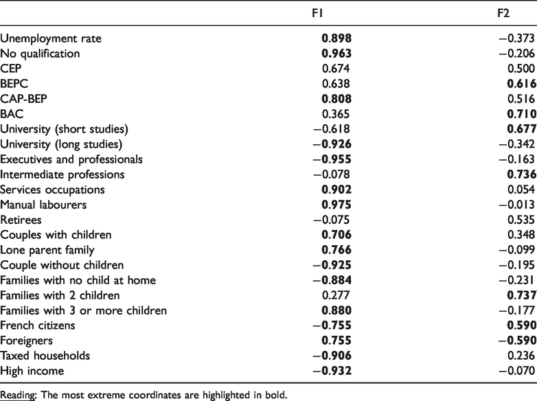
Before synthesising the spaces of Islamophobia and the space of inequalities, I provide an important reading and understanding of the existing social divisions in Paris. To do this, I produce a typological map that can be directly compared to the map of anti-Muslim acts (Figure 4). Other synthetic maps exist on the Parisian region – such as in Tovar (2010), Clerval (2016) or Clerval and Delage (2016) – but they do not focus exactly on Greater Paris and mostly concern only socio-occupational categories. Here, I use a HCA (Hierarchical Cluster Analysis) conducted on the first two factorial axes released by a PCA 8 (Principal Components Analysis). The PCA shows a percentage of total inertia for the first two factorial axes (F1 and F2) of 80%; the first factor is clearly dominant and well characterized, it is almost sufficient to describe the urban structure by itself (60%). The meaning between F1 and F2 can be read from the contribution of the variables to the factors in Table 2. F1 describes the socioeconomic situation ranging from the most privileged to the most deprived situation. The second axis is more difficult to analyse but the factorial graph of the statistical individuals representing the studied areas indicates that F2 describes characteristics related to the geographical space opposing the residential suburbs and the centre associated to the ZUS.
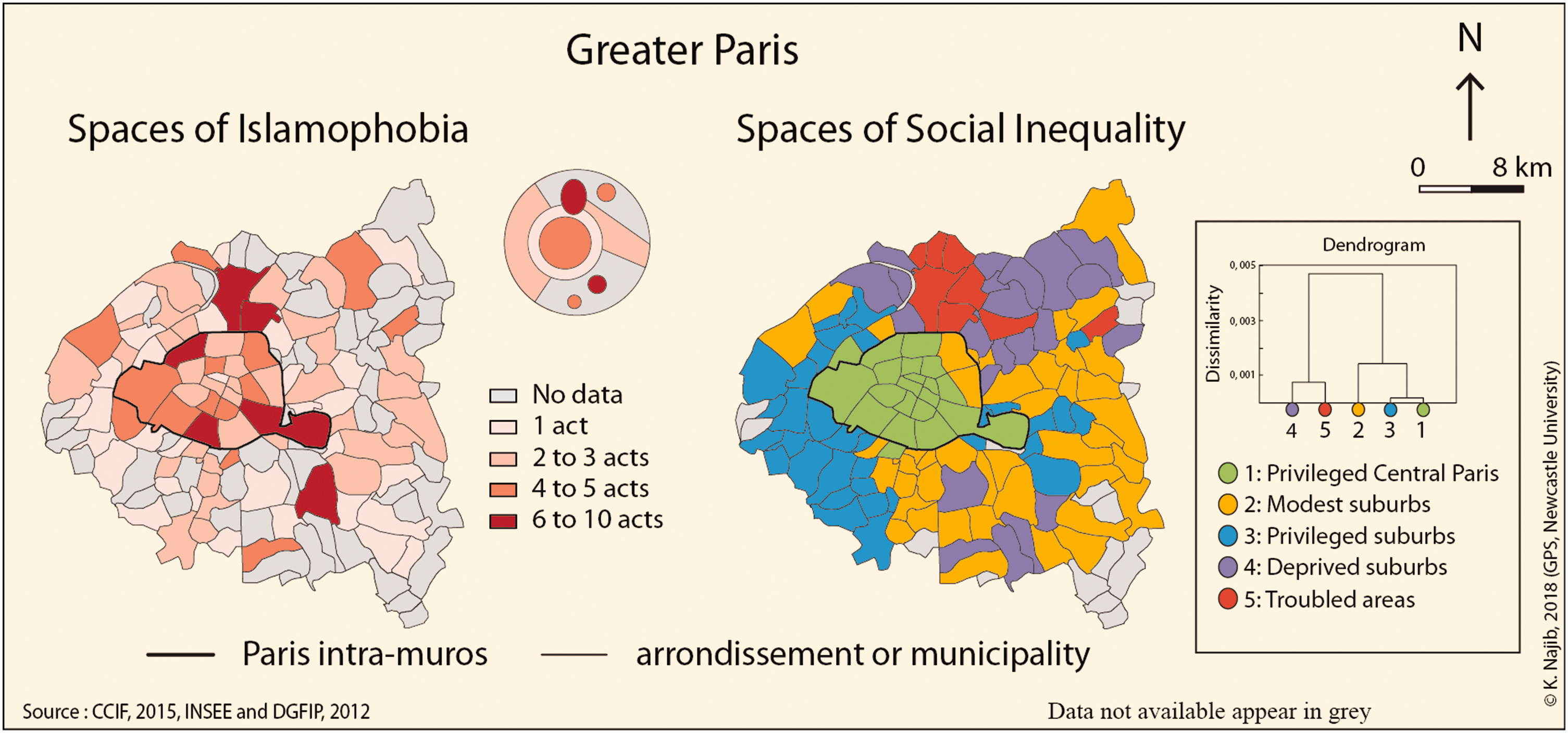
Comparison of spaces of Islamophobia and spaces of inequality in Greater Paris.
Coordinates of variables on the first two factors.
The HCA involves grouping areas according to a certain number of criteria of resemblance. Here, I decided to perform a HCA highlighting five classes in order to better characterize the different spaces of Paris. The dendrogram highlights detailed and visible socio-spatial inequalities, and more precisely: 1) privileged Central Paris (in green); 2) modest suburbs (in orange); 3) privileged suburbs (in blue); 4) deprived suburbs (in purple); and 5) troubled areas (in red). This classification exposing such social divisions can therefore be compared, in the figure below, to areas where Islamophobic acts have been recorded.
To sum up, spaces of Islamophobia highlight different important focal points such as 1) the Parisian centre; 2) municipalities in the northeast of Greater Paris, such as Saint-Denis and Aubervilliers, and to a lesser degree Aulnay-sous-Bois; and 3) municipalities located in the south of Greater Paris, such as Créteil and to a lesser degree Orly. These spaces of Islamophobia correspond to the locations where specific social groups live:
First, the mapping of anti-Muslim acts highlights specific patterns of spatial distribution showing visually the importance of the Parisian centre in contrast to the Parisian suburbs. There are a high rate of Islamophobic acts in the privileged Parisian centre where there is a high rate of executives/professionals (35%), high taxed households (76%), high incomes (median income of 33553 euros), high education levels (50%), couples without children (45%), and French citizens (86%). Second, spaces of Islamophobia also highlight ‘pockets’ of segregation in the department of Seine-Saint-Denis, and in particular the municipalities of Saint-Denis, Aubervilliers and Aulnay-sous-Bois. These municipalities are part of the 4th and 5th classes which represent deprived and troubled areas located in the suburbs. They are poor areas where there is a high rate of foreigners (30%), lone parent families (24%), large families (22%), manual labourers (26%), unemployed people (23%), uneducated people (40%) lower-income (median income of 11782 euros) and low-taxed households (48%), and a low rate of high education (8%). These two first sets of spaces where the great majority of anti-Muslim acts happen include both privileged and degraded areas, but they are less intense in degraded areas. Third, other focal points can be observed in the south of Greater Paris. There is an important focal point in the municipality of Créteil where Islamophobic acts happen. This municipality is part of the modest suburbs (class 2) where there is a high proportion of intermediate professions (18%) and people who have a secondary level of education (18%). There is also another focal point located in the municipality of Orly which is part of the deprived suburbs (class 4) where we can observe a high proportion of people with no qualification (30%), lone parent families (22%) and residents with a professional degree (19%). However, this last focal point of Orly is more notable for its airport than for potential geographical tensions between different social groups. That is why it is important to know the exact place where anti-Muslim acts happen, and not only the geographical or socioeconomic space.
The importance of places of Islamophobia
A distinctive geography of Islamophobia is presented and analysed in this paper, but the findings reveal that it is not so much the space and its social profile that matter but rather where the victims and the perpetrators encounter each other, that is to say where they work or move across the city. Therefore, the specific place where Islamophobic incidents occur seems to be more important as shown by Forrest and Dunn (2007) in their study on geography of racism in Sydney in which they explain that “place matters”. In France, places of Islamophobia are very important because the majority of incidents occur in institutional or professional places (Najib, 2019; Najib and Hopkins, 2020). At the Greater Paris scale, 69% of anti-Muslim acts are discrimination and 58% take place in a public institution – mostly in schools (28%), universities (8%) and training centres (8%) – and 21% at the workplace. They involve mostly veiled Muslim women (67%) who are discriminated against in a hierarchical context by teachers and directors of educational institutes (36%) or employers (13%) (who can be either women or men). Therefore, it is important to study the specific places where anti-Muslim acts occur within the different focal points highlighted in this article. The table below details the places where the Islamophobic incidents happened in the different focal points revealed by the spatial analysis: i) the Parisian centre; ii) the northeastern municipalities of Saint-Denis, Aubervilliers and Aulnay-sous-Bois, iii) the southern municipalities of Créteil and Orly.
Table 3 clearly shows that anti-Muslim acts happen mainly in public institutions or in the workplace. However, in the Parisian centre, public areas and public transport (16 acts) are also important. Anti-Muslim acts are more likely to happen in zones of contact in Paris intra-muros (compared to the other focal points) revealing important geographical tensions (Hancock, 2017; Hooks, 2000; Listerborn, 2015). Here, we can imagine that as soon as there is a form of mobility and commuting, there is also an increased risk of discrimination and aggression. In the Parisian centre, there are more jobs and educational and training centres (especially universities), and it is precisely when the Muslim populations leave the suburbs where they may live in great majority to work or to study in the centre that a high rate of Islamophobia is observed. Indeed, the statistics show that there are more Islamophobic acts in workplaces and educational and training centres in Central Paris. These observations can refer to the issue of self-segregation which may be sought and desired by the Muslim populations. However, this quantitative analysis shows that, on the contrary, and as in the study of Phillips (2006) which has challenged the discourse on British Muslim self-segregation, there is certainly a will and a necessity from Muslim populations to leave their residential areas and to enter different spaces and in particular the Parisian centre. However, when they try to access these different spaces, they may face an urban barrier as explained by Hancock (2017) in the form of the ring-like belt-structure that separates Central Paris from its banlieues. This demarcation line is administrative, symbolic and political (Amiraux and Simon, 2006), and this idea of urban barrier also refers to the idea of the glass ceiling concerning the professional evolution of one of the most marginalized and stigmatized minority groups (Aquil, 2011). Here there is also a geographical barrier.
Places of Islamophobia in the main focal points.
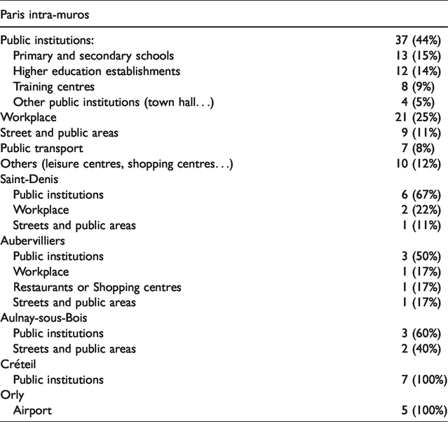
In addition, some researchers have shown in different cities a direct relationship between the degree of residential segregation and the degree of social distance between different groups (Gale, 2013; Massey and Denton, 1993; Peach, 1996; Taeuber and Taeuber, 1965; Voas and Williamson, 2000). They have explained that the degree of residential segregation between different groups is a significant reflection of social separation or interaction. In this sense, we know that Muslim populations may live in great majority in suburban ZUS, and at the same time, we know that they face greater anti-Muslim hostility in the Parisian centre (Najib, 2019; Najib and Hopkins, 2019). There is therefore a contrast (Hancock, 2017; Listerborn, 2015) between spaces generally socially valued but where anti-Muslim acts can happen in some streets and public areas, with spaces generally stigmatised and feared by the majority but where anti-Muslim acts are less likely in public areas. Although Table 3 shows that anti-Muslim acts can also happen in public areas in suburban municipalities such as Saint-Denis, Aubervilliers and Aulnay-sous-Bois, they are much less common. As for Créteil, the whole set of anti-Muslim acts happened in public institutions. This municipality is the administrative centre of the department as well as an important academic municipality famous for its school population. Finally, in Orly, all the anti-Muslim acts happen at the airport.
The mapping of anti-Muslim acts onto different areas in the social geography of the city shows that anti-Muslim acts happen more in privileged areas than in socioeconomically precarious areas. For example, the Parisian centre consists of a set of prestigious areas and the rate of anti-Muslim acts is higher than that of the department of Seine-Saint-Denis. However, this observation cannot lead to a specific conclusion such as ‘the more privileged a space is, the greater the risk of experiencing an anti-Muslim act’ because the privileged department of Hauts-de-Seine (which refers mostly to class 3) is less affected than the other departments. That said, in the department of Seine-Saint-Denis, anti-Muslim acts are concentrated in focal points here and there in poor municipalities, rather than being spread across the entire department; which is the case in Central Paris and the Hauts-de-Seine department where Islamophobia concerns all the arrondissements of Paris and almost all the municipalities of Hauts-de-Seine. In the latter department, 70% of the municipalities record at least one Islamophobic act. The relationships between Islamophobia and social inequality or spatial exclusion are significant because these relationships intersect mainly in central privileged areas.
In Greater Paris, institutional discriminations are higher whether in Central Paris or in the suburbs (although less numerous in the suburbs). Here, a special distinction needs nevertheless to be made: discrimination in public institutions in the suburbs mainly concerns secondary schools, while in Paris intra-muros it rather concerns training centres and universities. Indeed, in the suburbs, discrimination mainly affects young girls who agree to take off their headscarves at the entrance of their high school (in accordance with the 2004 French law 9 banning the headscarf in public schools), but still continue to be discriminated against for other reasons such as the length of a skirt for example (L’Express, 2015). In Central Paris, discrimination mainly affects adult veiled women who have the right to wear the veil at universities and training centres since the law is not applicable for higher education. However, these adult women still are discriminated against because of a false and abusive application of the 2004 law (by extension of its scope to people not concerned by this law). There is a clear relation to the application of the 2004 French law that can be seen as fostering such institutionalized discrimination: even if spaces of Islamophobia in Paris show a relationship with socio-spatial inequality, anti-Muslim hostility is above all an institutionalized consequence of the law. The specific place of Islamophobia seems to be more important than the socio-spatial areas in question, at least in the Parisian case. Conversely, in London, anti-Muslim acts mostly happen in public areas and public transport and victims are more likely to be passersby and shoppers (Najib and Hopkins, 2020). Thus, in this case, relationships play a more important role in London, which revives debates on how the different communities interact with each other in the UK, an interaction that operates mostly on the basis of “parallel lives” (Cantle Report, 2001; Phillips, 2006). In terms of future applied work, findings from this study are important in the case of London where places of Islamophobia are more likely to be specific categories of geographical space (such as public areas, streets, public transport, etc.). Future research on the London case should continue to investigate this relationship between geographies of Islamophobia and social inequality, using in particular British data on race and religion, and analysing qualitative attitudes to Islamophobia in the public space.
Conclusion
The primary objective of this paper was to explore the relationship between the geography of Islamophobia and the geography of inequality (socioeconomic, demographic, etc.). Paris and more generally France is an important study area for Muslim populations and their everyday lives. Indeed, France records the highest proportion of Muslims in Europe, both in reality and in perception (Duncan, 2016), and a high rate of Islamophobic acts (CCIF, 2016; Ray et al., 2004). In this article, the sense of place and space is discussed with reference to the emergent concern of Islamophobia. This paper reveals that spaces of Islamophobia are not necessarily areas where Muslim populations may live in great majority (such as the department of Seine-Saint-Denis and the suburban ZUS). It also reveals that Islamophobia occurs in specific places (such as public institutions and workplaces) and in specific spaces (such as the privileged area of Central Paris). Finally, indicators of societal attitudes to Islamophobia can lead us to question, for example, if Islamophobia can occur in places and spaces where the perpetrators feel comfortable with taking action, where they feel themselves to be in the majority or dominant.
On the one hand, previous research has already shown that Islamophobia is shaped by its intersections with other markers of inequality such as gender, race, age and class. On analysing the quantitative socio-demographic data of the victims, the main victims turn out to be young veiled Muslim women with a foreign background and a lower social class, and the intersectionality of Islamophobia describes a general domination already known in our contemporary societies, that is to say related to sexism, racism, ageism and classism (Najib, 2019; Najib and Hopkins, 2020). However, here what is highlighted is the place of Islamophobia in France that also describes a certain domination exacerbated by a false and abusive interpretation of the 2004 French law. Some public service employees believe that they have the right to extend the scope of this law to all the users of public services and institutions. And some employers prohibit the wearing of religious signs in their internal regulations – which can be, under certain conditions, illegal. Therefore, the ‘hierarchy’ found in the socioprofessional and administrative environment can add legitimacy to this type of illegal act via the 2004 law. Perpetrators may feel more comfortable and empowered to act in a certain way under formal professional and institutional protections. Islamophobia in France represents therefore a specific type of hate crime, and contrasts with Islamophobia or racism in other countries such as the UK where perpetrators are rather independent individuals moving across the city (Najib and Hopkins, 2020).
This paper also demonstrates that spaces where the great majority of anti-Muslim acts happen include both privileged and degraded areas, but they are less common in troubled areas. This research on Islamophobia brings out geographical tensions between the Parisian centre and the suburbs. Muslim populations, who are more likely to live in the suburbs, are necessarily attracted to the centre for different amenities, but they face more discrimination in the Parisian centre than in their everyday spaces (Najib and Hopkins, 2019). As explained earlier, we need to be cautious when referring to the residential location of Muslim populations in France because of the lack of official statistical data on religious affiliation. But it is possible to analyze the different spaces where the victims of Islamophobia live in Greater Paris. More exactly, the collected data include the residential location of the victims and show that spaces of Islamophobia are not usually spaces where the victims live. Among the 229 anti-Muslim acts that have occurred in Greater Paris in 2015, 65% of the victims live in the suburbs, compared to 18% 11 in Paris intra-muros. They have mostly experienced anti-Muslim incidents outside their everyday spaces, and especially in the Parisian centre. For example, among the 84 acts located in Paris intra-muros, 56% of the victims live in the suburbs, while 39% live in Paris intra-muros, and more precisely 16% in a different arrondissement (only 23% live in the arrondissement where the anti-Muslim act happened). As already suggested above, when there is a form of mobility, there is also an increased risk of discrimination and aggression. In this sense, Bell Hooks (1990 and 2000) has shown a similar geographical tension in the example of a Southern black community segregated from the white centre of town. She shows how Black community members realise who they are in the racist centre, just like some veiled Muslim women who explain that they feel “out of place” in the Parisian centre (Najib and Hopkins, 2019). This fear of a potentially unpleasant welcome or Islamophobic incident highlights an ‘emotional geography of risk’ (Kwan, 2008) that determines a specific ‘right to the city’ (Lefebvre, 1996) highlighting a right of accessing the prestigious Parisian centre.
This paper draws upon a research project that also includes empirical work using qualitative interviews with victims of Islamophobia living in Paris who provide important information on how they use spaces. The map of Islamophobia produced in this paper is from quantitative data collected by the CCIF and corresponds to the mental maps identified and shared by the interviewed victims of Islamophobia in Paris (Najib and Hopkins, 2019); they both demonstrate the specificity of the Parisian centre. Indeed, the quantitative data show that Central Paris is the department most affected by Islamophobic acts in Greater Paris, and are in line with the qualitative data that show that veiled Muslim women living in the Parisian region do not feel comfortable in Paris intra-muros (ibid.). Yet, Paris intra-muros can be seen as a capital city where there is a diverse population (but less diverse than in certain areas of the suburbs). In such area, there seems to be both an easy coexistence between different communities as well as the existence of racist and Islamophobic attitudes. Therefore, Muslim populations and notably veiled Muslim women do not feel comfortable in Central Paris – although they have a great ability to rub shoulders with different people in their friendly relationships. Indeed, Simon and Tiberj (2013) have shown in their study on friendly relationships based on gender, education, race and religion that Muslim populations, apart from an important gendered segregation, are the ones who have the most diverse friends, unlike for example Atheists and Catholics.
Finally, this paper shows the socio-spatial effects of Islamophobia and that the location of Islamophobia is not coincidental. Certain types of geographical spaces and socioeconomic spaces have a direct relationship with Islamophobia, but the specific places where anti-Muslim incidents happen appear to be more important. Spaces of Islamophobia also mostly involve people who do not live in the same area: attitudes are not only a consequence of spatial context, they can also be a consequence of collective behaviours in place-specific circumstances (Forrest and Dunn, 2010) and (geo)political events (Gökariksel and Mitchell, 2005). Therefore, research on geographies of Islamophobia can represent an important development for public engagement and education, and can help inform policy-making to prevent anti-Muslim discrimination.
Footnotes
Acknowledgements
I would like to thank Peter Hopkins for his careful readings, as well as the reviewers and the journal editors for their help with the revisions. Many thanks to my friend Josephine Ellis for her important proofreadings and my colleague Yohan Sahraoui for his cartographic help.
Declaration of conflicting interests
The author(s) declared no potential conflicts of interest with respect to the research, authorship, and/or publication of this article.
Funding
The author(s) disclosed receipt of the following financial support for the research, authorship, and/or publication of this article: This work was supported by the European Commission through a H2020 Marie Sklodowska-Curie Actions Individual Fellowship [Horizon 2020-MSCA-IF-2015-703328-SAMA (Spaces of Anti-Muslim Acts)].