
Abstract
Visible signs of disorder serve as markers of difference across urban space. Sociological theory suggests that variation in collective social control efforts contributes to variation in physical disorder. However, how structural characteristics shape differences in informal social control remains underexplored because of limited data on disorder and social control. Using city service request data and a novel dataset drawing on Google Street View imagery and computer vision methods, the authors examine the neighborhood characteristics associated with propensities to request trash-related services across five large U.S. cities. The authors find that socioeconomically advantaged neighborhoods and those with fewer minority and foreign-born residents have higher propensities. However, an increase in White residents, but not necessarily an increase in high–socioeconomic status residents, is strongly associated with greater propensities. The authors argue that incoming White residents introduce unique dynamics of social control that are not necessarily collective, thereby affecting spatial inequality and power relations within their new neighborhoods.
Visible signs of “disorder” in public spaces have long served as markers of difference across urban space. These markers powerfully affect the well-being of neighborhoods and residents and shape perceptions of both residents and outsiders about urban neighborhoods (Bursik 1986; Ross and Mirowsky 2001; Sampson, Morenoff, and Gannon-Rowley 2002). Such perceptions influence various neighborhood dimensions, including the valuation of neighborhoods, the willingness of residents to engage in collective action, and residential stability, with the potential to reinforce or diminish spatial inequalities. (Hunter 1985; Hwang and Sampson 2014; Jacobs 1961; Sampson and Raudenbush 1999). Thus, the visibility of disorder in public spaces has important implications for the trajectories of neighborhoods and their residents.
While the consequences of neighborhood disorder have invited rich scholarly and public debates, particularly around crime and policing, the causes of variation in disorder across neighborhoods have also generated theoretical interest among sociologists and criminologists. Early scholarship linked disorder with structural neighborhood characteristics like residential instability, immigrant concentration and ethnic heterogeneity, low socioeconomic status (SES), land use, and density (Cohen and Felson 1979; Shaw and McKay 1942). Although these structural characteristics may correlate with disorder, scholars have since focused on the intervening mechanisms that mitigate disorder, including a shared sense of responsibility (Jacobs 1961), collective efficacy: social cohesion among neighbors and shared expectations for the social control of public space (Sampson and Raudenbush 1999; Sampson et al. 1997) and residents’ territoriality or attachment to local space (Harris and Brown 1996; O’Brien 2015; Taylor 1988). These mechanisms often imply collective consensus across neighborhood residents to mitigate disorder. Still, ethnographies of neighborhoods undergoing gentrification and ethnoracial change underscore how these neighborhood-level social control efforts instead reflect the individual actions of residents from dominant groups imposing their own values and norms (Doering 2020; Hyra 2017; Pattillo 2007; Walton 2021). Indeed, collective outcomes emerge from individual actions (Coleman 1990; O’Brien 2016b), and these individual actions may not reflect shared expectations, values, and norms across a neighborhood’s residents.
A handful of studies have examined the ecological characteristics associated with collective efficacy and targeted behaviors to mitigate disorder. Research in this area has grown in recent years with the emergence of city service requests data (i.e., 311 data) across the United States, in which residents request city services via telephone, text, or an online portal (White and Trump 2018). However, studies have been limited by a lack of data on the presence of disorder, which has required substantial time and labor to collect. As neighborhoods have varying levels of needs for services; such requests are conditional on the actual presence of disorder. While a few studies account for the differential need for services to measure residents’ differential propensities to make requests (Kontokosta and Hong 2021; Levine and Gershenson 2014; O’Brien 2016a), in this study, we extend the discussion of need. Rather than simply comparing neighborhoods with similar needs for services, we delve deeper and analyze how different neighborhood characteristics relate to sensitivity to increasing need for services. Furthermore, extant studies using city service request data have produced mixed results on the correlates of service requests by ethnoracial, immigrant, and socioeconomic compositions and the types of requests (e.g., snow plows, public denigration, noise complaints, sidewalk and street repairs, street light outages) (Kontokosta and Hong 2021; Legewie and Schaeffer 2016; Levine and Gershenson 2014; Minkoff 2016; O’Brien 2016a; O’Brien, Sampson, and Winship 2015).
In this article, we draw on a novel large-scale longitudinal dataset measuring the presence of trash, specifically litter or garbage in public space, and 311 service requests for trash-related issues across five large U.S. cities to revisit theories of informal social control. We examine the structural neighborhood characteristics, including ethnoracial and socioeconomic change, associated with propensities to make trash-related service requests as trash increases within a neighborhood. To do this, we use a novel dataset generated using crowdsourcing, computer vision (CV), and a large corpus comprising millions of Google Street View (GSV) images over several years in Austin, Texas; Boston; Detroit; Los Angeles; and Philadelphia.
Our findings contribute to literature on spatial inequality, neighborhood disorder, social control, and urban change in three important ways. First, they demonstrate how service requests to mitigate disorder are positively associated with more socioeconomically advantaged, White, and native-born residents and neighborhoods with signs of gentrification, where social control is unlikely to stem from collectively shared expectations across the neighborhood. Second, our results show that an influx of White residents, and sometimes, but not always, an influx of high-SES residents, is associated with higher propensities to make trash-related requests, suggesting that incoming White residents bring unique dynamics of social control that are not necessarily collective. Third, our data allow us to shed light on the selectivity of city service requests, contributing to methodological debates on the validity of 311 requests as a proxy for urban disorder. Given that physical disorder serves as a cue for neighborhood stigma and crime and affects residents’ well-being (Sampson and Raudenbush 2004; Sampson et al. 2002), if requests for service, and presumably subsequent receipt of services, are unevenly distributed, this reinforces spatial inequality and carries consequences for racial inequality more generally.
Physical Disorder and Informal Social Control
Physical forms of disorder—such as garbage on the street, graffiti, and abandoned buildings and lots—indicating that a neighborhood is poorly maintained or monitored have long been the subject of research on urban neighborhoods (Sampson 2012). Arguably the most prominent treatment of physical disorder in sociology stems from work by Sampson and Groves (1989), Sampson et al. (1997), and Sampson and Raudenbush (1999). Sampson and Groves argued that structural neighborhood characteristics relate to disorder through the mediating factor of social control: the capacity of neighborhoods to realize a collective good, such as mitigating disorder in public spaces. Social control can be exerted through formal channels, such as police officers, or informal channels, such as neighbors. Accordingly, structural factors at the neighborhood level, such as residential instability, ethnoracial heterogeneity, and socioeconomic disadvantage, are associated with the reduced capacity of a neighborhood to exercise informal social control to mitigate disorder, and collective efficacy—the mutual trust and solidarity between neighbors and shared expectations to exercise informal social control—forms the backbone of this capacity (Sampson et al. 1997). In subsequent work, Sampson and Raudenbush (1999) collected and analyzed data on physical disorder in Chicago neighborhoods and found that socioeconomic disadvantage, ethnoracial heterogeneity measured as immigrant concentration, and perceived physical disorder, but not residential instability, are strong correlates of physical disorder and that collective efficacy on the basis of resident surveys mediates these associations. They further showed that the racial and socioeconomic context has stronger effects in shaping perceptions of disorder than actual levels of disorder (Sampson and Raudenbush 2004).
Related theoretical treatments of the varying presence of physical disorder across neighborhoods have focused on the presence of guardians—those who keep their eyes on public spaces, mitigate incivilities, and foster community well-being—and the individual-level characteristics associated with guardianship (Cohen and Felson 1979; Jacobs 1961). The routine activities theory, stemming from criminology, points to land use and density, indicators of where more people frequent via routine activities such as work and shopping, as factors that influence where guardians are present and thus opportunities for disorder to arise (Cohen and Felson 1979). Jacobs (1961) argued that guardianship arises when residents feel a sense of responsibility to their neighborhood. Feelings of public responsibility and desires for social organization may be entrenched in territoriality—residents’ claims of ownership and responsibility for their neighborhood—especially in contrast to other spaces (Harris and Brown 1996; O’Brien 2016a and 2016b; Perkins, Meeks, and Taylor 1992).
These theoretical models focus on the neighborhood-level characteristics that facilitate or impede outcomes mediated by informal social control efforts. All imply that informal social control stems from the actions of individuals, but largely frame these actions as collective. However, there may be substantial variation across individuals that may still result in neighborhood-level outcomes (Coleman 1990). Differences across neighborhoods in the propensity to make 311 requests concerning disorder may be due to varying perceptions of disorder; feelings of personal responsibility for public space, or custodianship, which may be higher among homeowners; and/or collective cynicism (O’Brien et al. 2015). Examining 311 service requests associated with public incivilities in Boston, O’Brien (2015) found that homeowners are more likely to exhibit custodianship, especially in a small geographic range around their residence, and only a small share of residents make requests for 311 services (O’Brien 2016b). In a subsequent survey of residents who made 311 service requests associated with public incivilities in Boston, O’Brien (2016a) found that residents are indeed motivated by feelings of ownership and responsibility for public space around them and, secondarily, by motivations to benefit the community.
Others frame city service requests as a citizen-state interaction that, under certain conditions, demonstrates political will and engagement and consequently relates to how government resources are allocated spatially (Levine and Gershenson 2014; Minkoff 2016). The findings from these studies highlight the distinction between requests for government-provided goods, such as trash collection and snowplows, and requests for mitigating disorder. Examining service requests for snowplows in Boston, Levine and Gershenson (2014) demonstrated that, conditional on need, neighborhoods with more Black residents are more likely to request services, whereas high-immigrant neighborhoods are less likely. Levine and Gershenson (2014) argued that the expectation of neglect rooted in experiences of discrimination by Black residents may foster more frequent requests for service, whereas immigrants’ decreased likelihood of contacting the government may be due to unfamiliarity with government or distrust (Levine and Gershenson 2014; Maxwell 2008). In contrast, in an analysis of service requests for sidewalk repairs and streetlight outages in Boston, O’Brien (2016a) found that, conditional on need and the numbers of highly engaged residents in a neighborhood who make reports, the share of Hispanic residents is positively related to reporting propensity, whereas percentage foreign-born and percentage Black are unrelated. In another study using street audit data to account for need, Kontokosta and Hong (2021) found that predominantly lower income and minority neighborhoods in Kansas City tend to underreport issues related to street repairs. Although others have examined differences across neighborhoods in making service requests, only the aforementioned studies account for need, which is necessary because requests can reflect higher incidents of incivilities or greater demands to mitigate them.
Neighborhood Change and Policing Disorder
Collective efficacy theory posits that social cohesion, mutual trust, and shared expectations at the neighborhood level are necessary to intervene to maintain order in a neighborhood and that residents are unlikely to act when rules are unclear or when people mistrust one another (Sampson et al. 1997). However, research on neighborhood change suggests that when it comes to mitigating disorder, efficacy among a subset of residents may be all that is necessary and may be heightened in neighborhoods undergoing change, even when residential instability and ethnoracial heterogeneity are high. For example, gentrifiers who feel invested in the future of the neighborhood, particularly in the increased value of their property, may view the neighborhood as a space to be “tamed” (Brown-Saracino 2009; Smith 1996).
Ethnographic work of neighborhoods undergoing gentrification—the influx of investment and high-SES residents into previously low-income urban neighborhoods (Smith 1998:198)—suggests that only a subset of residents making demands, even if not consensual with other residents, can have neighborhood-level outcomes. Gentrifiers’ political interests often win out as they exercise their political voice and make demands that privilege their own norms and values (Hyra 2017; Martin 2007; Pattillo 2007). Even among gentrifiers, however, there may be conflicting interests. For example, Doering’s (2020) ethnography of a gentrifying Chicago neighborhood presents groups of gentrifiers conflicting over whether to police social disorder or preserve it (see also Brown-Saracino 2009). Walton’s (2021) study of two multiethnic gentrifying neighborhoods in Boston highlights the cultural processes particular to White gentrifiers, who express anxiety around a sense of danger and, subsequently, emphasize social order, rules, and surveillance. Walton labeled this behavior a “habit of whiteness” perpetuating racial domination in such spaces. Similarly, in a study of gentrifying neighborhoods in New York City, Freeman (2006) described gentrifiers’ desires to make urban space more “habitable” as imbued in whiteness. Although the socioeconomic change from gentrification may explain differential propensities to make demands to maintain order, these latter studies suggest that racial change may be more pertinent.
Quantitative studies examining how residents police disorder in changing neighborhoods lend further insight. Collins, Stuart, and Janulis (2022) demonstrated how police citations in Los Angeles are higher in gentrifying neighborhoods with high levels of low-income displacement relative to other neighborhoods. Although citations may reflect broader policies by state actors that promote gentrification in particular neighborhoods, they may also stem from demands of a subset of residents. In a study of New York City 311 requests regarding complaints against neighbors, Legewie and Schaeffer (2016) found that such complaints are higher in areas of ethnoracial diversity that experienced rapid ethnoracial changes and are located between homogenous areas. Although their data cannot show whether the complaints reflect groups complaining about the other or the demands of a single group, Legewie and Schaeffer (2016) argued that mechanisms of group threat—such that the presence of one group invokes prejudice from another, ambiguity about social rank, and contested claims about territory—all operate in such areas to invoke neighborhood conflict.
Therefore, shared expectations and cohesion across neighborhood residents may not be necessary in places where efforts to mitigate disorder are high. Instead, neighborhoods experiencing gentrification may have increased propensities to make requests to mitigate disorder as such efforts to establish territoriality may be especially salient in these neighborhoods. Such requests to maintain order may be driven by “habits of whiteness” (Walton 2021) rather than high-SES residents alone. For our analysis, in addition to the structural characteristics associated with neighborhood-level social control posited by prior scholarship (SES, racial and nativity composition, and residential stability), we test if gentrification, as well as whether an increase in White residents as opposed to socioeconomically advantaged residents, explains differences across neighborhoods in residents’ propensities to make requests to maintain order. Specifically, we exploit the geographic granularity of our data to consider the spatial embeddedness of these racial and socioeconomic changes within broader neighborhood contexts to better understand the sources of demands for social control. If sections of neighborhoods experiencing increases in White or high-SES residents have higher propensities to make 311 requests relative to other sections of the neighborhood, this would suggest that the requests stem from White or high-SES residents rather than from collective efforts by residents across the neighborhood.
Measuring Disorder and Informal Social Control
Despite the long-standing interest in the social sciences to understand disorder and informal social control, empirical scholarship has remained relatively limited due to difficulties with data collection. Few studies use observations of both incivilities and responses (or lack thereof).
Most research on disorder has relied on resident surveys to measure it, but these perceptions do not necessarily reflect objective levels of disorder (O’Brien, Farrell, and Welsh 2019). Furthermore, examining informal social control across neighborhoods has also been difficult without data on the objective presence of objects or events to account for baseline differences in the presence of “disorder” that warrant acts of social control.
Early efforts to systematically observe neighborhoods were in the form of in-person audits, wherein trained researchers walked around neighborhoods and filled out surveys tracking neighborhood characteristics, including disorder (Perkins et al. 1992; Taylor, Shumaker, and Gottfredson 1985). These audits yielded important insights into neighborhood physical conditions but were limited in spatial and temporal scope because of time and labor constraints. In line with the approach of these in-person audits, but greatly expanded in scope and reliability, the Project on Human Development in Chicago Neighborhoods used camcorders to record a large number of street blocks across Chicago (Sampson 2012). By recording the street segments, researchers could analyze blocks without time limitations and costs of being in the field, and multiple researchers could analyze and reanalyze the same blocks to improve the reliability of the results (Sampson 2012). This undertaking, however, was still limited in scope to a sample of Chicago neighborhoods and one point in time.
The next technological innovation for neighborhood audit studies was GSV, which provides a publicly accessible online platform with which researchers can observe a high density of panoramic images that simulate walking down a street. By providing a way for researchers to systematically observe visible characteristics of places, including the presence of disorder, GSV has been used to examine homeless encampments (Finnigan 2021), indicators of gentrification which include the absence of disorder (Hwang and Sampson 2014), building characteristics (Hipp et al. 2022; Langton and Steenbeek 2017), and disorder itself (Mooney et al. 2017; Odgers et al. 2012).
Although GSV significantly reduces the costs of neighborhood audits, the scale of data and how to process and analyze it presents its own new challenges. The research described previously is still limited to single time points, samples of street segments or neighborhoods, and/or a handful of cities (Hwang 2017).
With the proliferation of city service requests data, some scholars have used these data as measures of disorder (e.g., Athens et al. 2020; Li et al. 2020). However, these data better reflect interresident neighborhood dynamics, such as ethnic tension, territoriality, advocacy, informal social control efforts, or some aspects of political engagement (Legewie and Schaeffer 2016; Lerman and Weaver 2014; Levine and Gershenson 2014; O’Brien 2018; O’Brien et al. 2015, 2017; White and Trump 2018). Requests to 311 services are jointly determined by an individual resident’s propensity to use 311 and an actual reason to make a request (Minkoff 2016; O’Brien et al. 2015). To better understand the relationship between physical disorder, informal social control, and structural neighborhood characteristics, data on the actual presence of disorder and efforts to mitigate it are necessary. Studies using such data thus far are few and far between and are limited in their geographic and temporal scope. Our study expands upon this work by using a novel large-scale dataset of measures of trash and 311 data across five large U.S. cities.
Data and Methods
Measuring Trash with Street-Level Imagery and CV
To test our research question, we use a novel dataset to measure trash—specifically garbage or litter in public spaces. We constructed these data from a large corpus of images from GSV with crowdsourcing and machine learning methods. GSV is a free, publicly accessible platform of nearly full-rotation panoramic views from the street level for many places around the world and with nearly full coverage in major cities. The images are primarily collected with a rotating camera mounted on top of a vehicle, and images date back to 2007 and are collected every one to three years. Thus, GSV offers a novel source of large-scale longitudinal and geographically rich data on the visible features of places. The dataset we draw on spans five U.S. cities—Austin, Boston, Detroit, Los Angeles, and Philadelphia. Our analysis for this study focuses on the nearly 5 million images from 2015 to 2019. We focus on these years as these are the years for which we have both GSV and city service requests data in each city. In this section, we summarize the methods to construct this database, and more details are available in Hwang and Naik (2023).
To construct this database, we first extracted and curated GSV images from each of the cities. We aimed to emulate street audits in prior studies, so we collected a high density of images on every block. Using parcel inventories from each city, we sampled approximately four parcels on each side of a street segment. For each location, we collected all the images available over time. To generate a readable dataset of images without manually screening millions of images, we use CV techniques to preprocess the images by filtering out images that would make identifying whether there is trash in an image difficult: when images are blurry or when the camera is misdirected. Overall, we removed about 7 percent of images from the original dataset and found no systematic differences in where the unusable images were located.
After we compiled a curated dataset of images, we collected and curated training data to train a model to identify trash in the full set of images. We used Amazon’s Mechanical Turk (AMT), a crowdsourcing platform that enables researchers to get labeled data at low costs and fast speeds, to identify the presence of trash in images for approximately 15,000 images distributed across three of the cities (Boston, Detroit, and Los Angeles). 1 The first survey asked AMT workers whether an image contained trash, and five separate AMT workers rated each image. If at least four raters classified the image as not having trash, we labeled these images as having no trash. The remaining images were advanced to the second-stage survey, in which we presented AMT workers with randomly generated pairs of images and asked them to pick which image had more trash. Every image was compared at least 18 times, and we employed a ranking algorithm, Microsoft TrueSkill, to produce a continuous score of trash levels for each city on the basis of the results from the pairwise comparisons. On the basis of these results and visually inspecting the images, we identified the TrueSkill score for each city for which images below that score did not contain trash. This approach mitigates issues with reliability due to bias in determining trash levels across raters and human error (Hwang et al. 2023; Naik et al. 2017; Solymosi, Bowers, and Fujiyama 2018).
Using the labeled training data, we trained a CV model using a two-stage process. In the first stage, we fine-tune a pretrained ResNet50 model, a popular residual neural network model trained on a wide variety of objects in images from the ImageNet database (https://www.image-net.org), to extract features of the images. In the second stage, we use a support vector machine algorithm, a commonly used machine learning technique for classifying images into categories.
We then predicted the presence of trash on the full set of preprocessed images. Across all the images, the model predicted that 14 percent, 24 percent, 55 percent, 14 percent, and 33 percent of all images in Austin, Boston, Detroit, Los Angeles, and Philadelphia, respectively, to have trash. For validation, we compared our predictions to a randomly selected subset of images that human raters labeled, yielding high reliability and an overall agreement of 86.7 percent.
Using the predicted presence of trash for the full set of images, we create aggregate measures for census block groups—the smallest geographic unit for which publicly available demographic and housing estimates are available—to proxy the prevalence of trash. Although GSV and 311 data are available at the street level, we aggregate our data to a larger spatial unit to approximate spatial differentiation in the general prevalence of trash across block groups for a few reasons. First, Mooney et al. (2017) demonstrated that although reliability may vary for individual items for specific blocks, audits using GSV generate high reliability when aggregated to larger spatial units. Furthermore, while previous research (O’Brien et al. 2015) has linked street-level audits to specific 311 reports, we do not have the specific date and time of the visible trash in our GSV data. In addition, Google revisits specific locations irregularly, and thus some locations have more frequent intervals of imagery than others. Thus, we do not observe each specific location of an image at the same frequency.
Because the images were not sampled evenly or randomly across street segments, for each year, we average the percentage of images in each street segment side, or block face, estimated to have trash. Then, we calculate the average of the block face proportions within each block, and finally, take the average of the block aggregations within each block group. Table 1 presents descriptive statistics of the prevalence of trash across block group-years for each city used for our analysis, and Figure 1 illustrates the distribution of the prevalence of trash across block groups in each city for the most recent year of images available when the data were collected, where darker colors represent more trash prevalence. The table and figure illustrate the considerable spatial variation in the prevalence of trash across and within cities.
Descriptive Statistics of Trash Prevalence by Block Group-Year and City.


Maps of Block Group-Level Trash Prevalence by City.
City Services Requests
We compile publicly available city services request data from the same five U.S. cities. Requests data are available for all five cities in the years 2015 to 2019. Each city’s dataset includes information about each service request, including the date, location, and a description, but the data do not contain information on who makes the requests across all cities. Each city categorizes the requests idiosyncratically and provides varying levels of detail in request descriptions, which presents a challenge in aggregating and comparing across cities. To ensure that we are measuring the same construct of trash-related service requests across all cities, we standardize the categorizations to a case-type categorization implemented by O’Brien et al. (2015) in Boston, which codes all requests that mention excessive trash, abandoned items, illegal dumping, and improper storage of trash as a trash-related service request. We apply this categorization to all cities. Following O’Brien et al., we exclude requests for trash pickup contained in bins or bulk pickup, as this reflects a personal request rather than public physical disorder.
We geocode each service request to its corresponding census geography and count the number in each census block group. For comparability with the GSV data, we aggregate the 311 data to the census block group. Using the open date of each request, we generate a block group-year dataset, with the number of requests in each block group in each year. However, our main outcome variable is the per capita number of reports to account for varying populations across census block groups. Figure 2 presents the distribution of 311 reports per capita from the final dataset in each block group by city, highlighting both across- and within-city variation in 311 reports. Each request also includes information on the open and close date of the request. In a supplementary analysis discussed below, we also measure the number of days it takes to fulfill each service request as a proxy of expectations for government responsiveness.
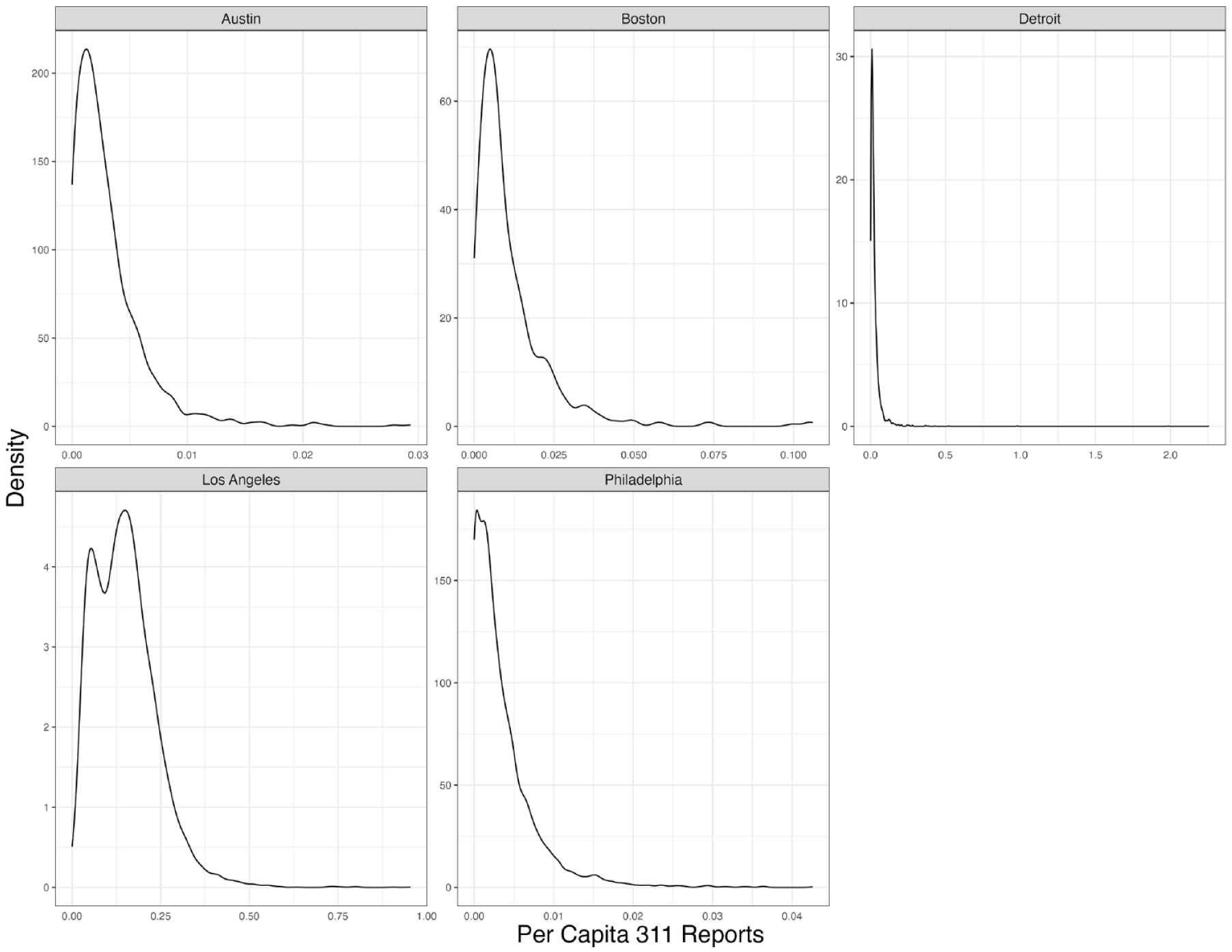
Distributions of Block Group-Level Per Capita 311 Reports.
Neighborhood Characteristics
We assess structural neighborhood characteristics associated with propensities to make trash-related service requests drawing from prior theory and research described previously. Although our GSV and 311 data are aggregated to the block group to exploit the granularity of these data, we measure neighborhood characteristics at the census tract to capture the larger spatial context in which the service requests and trash prevalence occur. 2 First, we assess racial composition and immigrant share, which were significant predictors of propensities to make service requests in Boston (Levine and Gershenson 2014; O’Brien et al. 2015). To do so, we examine percentage Black, percentage Hispanic, percentage Asian, and percentage foreign born using data from the 2015 to 2019 (hereafter, 2019) American Community Survey (ACS). This ACS best overlaps with our dataset and thus assumes that tract characteristics are constant from 2015 to 2019. We also examine measures of residential stability and socioeconomic advantage from the 2019 ACS data that others have linked to custodianship and collective efficacy (O’Brien et al. 2015; Sampson et al. 1997; Shaw and McKay 1942). These measures include the shares of renters and median household income. Table 2 presents the means and standard deviations of each variable for each of our sample cities.
Descriptive Statistics for Tract-Level Independent Variables by City.

Note: Values in parentheses are standard deviations.
Additionally, we examine how neighborhood change is associated with propensities to make trash-related service requests. To measure gentrification, we draw on census tract-level variables from the 2006 to 2010 (hereafter, 2010) and 2019 ACS. We exclude tracts with fewer than 100 residents or 50 housing units in either ACS. Although the measurement of gentrification lacks consensus within the literature (Brown-Saracino 2017), we operationalize it by adapting from measures developed by Ding, Hwang, and Divringi (2016) and Hwang (2020). We identify census tracts that are gentrifiable—relatively low-income tracts in 2010 that can undergo gentrification—and then identify whether and to what degree they experience influxes in high-SES residents and housing prices from 2010 to 2019.
We categorize a tract as gentrifiable if its median household income is below the city’s median household income in 2010. Considering only gentrifiable tracts, we categorize a tract as gentrifying if (1) either the percentage change in median rent or home value is greater than the median percentage change across tracts in the city with increases in these measures and (2) either the percentage change in share of college-educated residents 25 and up or median household incomes is greater than the median percentage change across tracts in the city with increases in these measures. Among gentrifying tracts, we further categorized them by their stage of gentrification, on the basis of their housing prices at the end of the period in 2019. Tracts with both median rents and median home values in the lowest quartiles for each variable in the city are categorized as early-stage gentrification, and tracts with either median rents or median home values in the highest quartile in the city are categorized as late-stage gentrification. All other gentrifying tracts are classified as middle-stage gentrification. Figure 3 displays the proportion of tracts in each category by city. 3 The figure shows that Austin has the most tracts undergoing gentrification, while Detroit has the fewest, and most gentrifying tracts are categorized as middle-stage gentrification.

Gentrification Stage Distribution by City.
Although our data do not include information on who is making requests, we assess changes in residents at the block group level to infer who may be making requests within a tract. More specifically, we consider changes in the SES of residents and White residents in the census block groups within a tract. To measure the change in high-SES residents (S), we construct an additive index of the change in the number of college-educated residents (C), and change in the median household income (I), between the 2010 and 2019 ACS surveys:

Although we calculate the percentage change in median household income, the change in college-educated residents is relative to the total population in the 2010 survey to account for block groups with low baseline college-educated populations, as a percentage change may exaggerate their increases. We add the change in college-educated residents and the change in median household income together and standardize to a mean of zero by creating a z score. Here, all positive values correspond to an increase in income and college-educated residents:

We measure the change in the White population in a block group by constructing an index of change that is the increase or decrease in the White population relative to the total population in the 2010 survey:

We similarly standardize this value to a mean of zero, where all positive values correspond to an increase in the White population. We use these measures to determine whether differential propensities to report trash reflect influxes of high-SES or White residents in some parts of a census tract.
Finally, we draw from publicly available parcel and land use data from each city and calculate the share of land area in each census block group in the following zoning categories: residential, commercial, public, industrial, mixed-use, and roads. We include these as control variables in our models to account for differences in the propensity to make 311 requests across neighborhoods with different land uses to account for routine activities (Cohen and Felson 1979). Linking data on city services requests, trash measures, and neighborhood characteristics, our final dataset contains 13,728 observations of block groups in each year of analysis. 4
Analytic Strategy
We estimate weighted quasi-Poisson regression models where the outcome variable is the number of service requests for trash-related issues at the census block group level. In particular, the model is specified as follows:

where Y is the number of service requests, P is the population of the census block group, T refers to the prevalence of trash derived from GSV data, and
Fifth, to capture the differential propensity of reporting trash across neighborhoods, we focus on the interaction terms between focal neighborhood characteristics and the prevalence of trash (i.e., T
Furthermore, we model the relationship between each focal predictor and the reporting propensity separately instead of having more than one focal predictor in a model because we do not treat the focal predictors as either confounders or mediators of one another. In all models, along with the interaction terms, we also include the main effects of the variables involved in the interaction terms, as well as city and year (of the GSV and 311 data) fixed effects. 6 To account for the secular temporal trend and different ways the 311 systems are set up across cities, we also include interaction terms between trash prevalence and city and year indicators in all models, as well as the main effects of these indicators. Similarly, we control for the zoning characteristics of the census tracts in all models.
To examine demographic changes within census tracts, we analyze two block group-level characteristics: change in high-SES residents and change in the White population. We report results from models with an interaction term between these block group-level variables and the GSV trash prevalence estimates. We run these latter models with interactions for gentrifiable tracts and majority-minority tracts (<50 percent White) to test whether propensities to make requests driven by socioeconomic or racial changes are particular to lower income and minority neighborhoods undergoing change. With models specified in this way, we can investigate the associations between the block group-level demographic changes and reporting propensities net of larger contextual forces at play in the tracts to test the degree to which propensities to make requests are collective efforts across neighborhoods.
Results
Structural Neighborhood Characteristics and Informal Social Control
We first present results with respect to “static” tract-level neighborhood characteristics in Table 3. 7 Model 1 examines racial composition and implicitly uses percentage of White residents as the reference group by including percentage Black, percentage Hispanic, and percentage Asian residents in the model. Throughout, we focus on the interaction terms between the focal neighborhood characteristics and the prevalence of trash in each year in each block group. Thus, coefficients can be interpreted as the associations between the neighborhood characteristics and sensitivity to increasing observed trash. From model 1, neighborhoods with higher percentages of all minority residents have lower reporting propensities. Using the coefficients for the main effects presented in the Supplemental Appendix, a 1 percentage point increase in percentage Black from 50 to 51 percent in a neighborhood is related to a 1.61 percent decrease in reporting propensity. Comparable increases for percentage Hispanic and percentage Asian in a neighborhood correspond to a 2.13 percent and 3.57 percent decrease in reporting propensity, respectively. As the implicit reference group, we can infer that neighborhoods with greater shares of White residents thus have higher reporting propensities of trash. These results are inconsistent with Levine and Gershenson (2014), who find higher propensities to make 311 requests for snowplows in neighborhoods with greater shares of Black or Asian residents in Boston. However, the presence of trash may invoke differential responses than the need for snowplowing or sidewalk and streetlight repairs, and dynamics may also differ across more cities.
Coefficients for Poisson Models Predicting Logged 311 Requests per Capita.

Note: Corresponding main effects are also included in the models but omitted from the table. For all coefficients, see the Supplemental Appendix. The coefficients and standard errors are multiplied by 100 for ease of presentation. Values in parentheses are standard errors. Models are weighted by the square root of the number of Google Street View images. An offset variable, log population of the block group, is applied. Standard errors are calculated using the quasi-Poisson model. Zoning, year, and city are entered into the model in both main effects and interaction effects with trash presence. Observations containing missing values in any variable are excluded. N = 13,728.
p < .001.
The subsequent models in Table 3 examine additional characteristics that past literature has tied to informal social control: SES, immigrant concentration, and residential instability. Model 2 shows that reporting propensities are higher when the median household income of the tract is higher, in which a 1 standard deviation increase above the mean is associated with a 96.6 percent increase in reporting propensity. This is consistent with preexisting theory but inconsistent with findings by Levine and Gershenson (2014), who found no relationship between median household income and propensities to make requests. In model 3, the percentage of foreign-born residents is negatively associated with reporting propensities, which is consistent with Levine and Gershenson’s (2014) findings in Boston. Finally, model 4 shows that tracts with higher shares of renters have lower reporting propensities, which is consistent with O’Brien’s (2016a) results in Boston. Furthermore, they are consistent with past theory and research arguing that residential instability and ethnic heterogeneity limit the capacity for residents to exercise informal social control to mitigate physical disorder (e.g., Sampson and Raudenbush 1999; Shaw and McKay 1942). The lower propensities to make requests in tracts with high shares of renters may also reflect lower levels of territoriality (Harris and Brown 1996).
In supplementary analyses, we consider whether these observed heterogeneities are reflective of varying patterns or expectations of government responsiveness. In neighborhoods with slow response times, residents may be less likely to make requests because of collective cynicism (O’Brien et al. 2015) or may make more requests from expectations of neglect (Levine and Gershenson 2014). We first check whether the time it takes to close, or resolve, requests varies systematically by neighborhood characteristics. Appendix Table A1 presents these results. We find that several neighborhood characteristics are largely unrelated to median time to resolution for requests; however, percentage Black and percentage Hispanic within a block group are positively and significantly related, suggesting that neighborhoods with more minority residents have longer resolution times for trash service requests. To test if potential differences in the observed patterns in Table 3 are in response to longer resolution times, we ran all models controlling for the previous year’s logged median resolution time for trash requests as a measure of expectations of government responsiveness and present these results in the Supplemental Appendix. All patterns of heterogeneity remain consistent even when we control for this measure of expectations of government responsiveness or neglect, suggesting that this is not a driving factor in the results.
In summary, the results in Table 3 are primarily consistent with theory on the neighborhood structural characteristics associated with informal social control, though they are somewhat inconsistent with recent research using 311 service request data in Boston. 8 We find that neighborhoods with higher income, lower immigrant concentration, and lower shares of renters have higher propensities to make trash-related service requests. Moreover, neighborhoods with lower shares of Black, Asian, and Hispanic residents have higher propensities to make requests as trash increases within a neighborhood. Next, we consider the dynamics of neighborhood change that may explain variation across neighborhoods in city service requests to mitigate disorder.
Neighborhood Change and Social Control
In Table 4, we test whether neighborhood changes are associated with differential propensities to make 311 requests. As before, interaction coefficients can be interpreted as indicating associations between dimensions of neighborhood change and reporting propensities. Model 1 examines the tract-level gentrification status with nongentrifying neighborhoods as the reference category. Consistent with the results shown earlier, relative to neighborhoods that were not gentrifying, nongentrifiable neighborhoods, which are high-income neighborhoods, have significantly higher propensities to make trash-related service requests. At the same time, tracts experiencing late-stage gentrification also have higher propensities to report trash via 311; relative to a nongentrifying neighborhood, a late gentrifying neighborhood on average has a 235 percent higher reporting propensity, on the basis of the main effects reported in the Supplemental Appendix. We find no differences in the propensities to report trash among early- and middle-stage gentrifying neighborhoods compared to nongentrifying neighborhoods. This finding implies that informal social control efforts may be heightened in tracts that are experiencing the latest stages of upgrading relative to other gentrifying neighborhoods. As gentrification progresses, the newest gentrifiers in an already gentrifying neighborhood may have higher expectations for the quality and infrastructure of trash prevention and cleanup, and thus may disproportionately contribute to 311 reports.
Coefficients for Poisson Models for Neighborhood Change Predicting Logged 311 Requests per Capita.

Note: Corresponding main effects are also included in the models but omitted from the table. For all coefficients, see the Supplemental Appendix. The omitted reference category for the gentrification stage is “not gentrifying.” The coefficients and standard errors are multiplied by 100 for ease of presentation. Values in parentheses are standard errors. Models are weighted by the square root of the number of Google Street View images. An offset variable, log population of the block group, is applied. Standard errors are calculated using the quasi-Poisson model. Zoning, year, and city are entered into the model in both main effects and interaction effects with trash presence. Observations containing missing values in any variable are excluded. N = 13,728. SES = socioeconomic status.
p < .01. ***p < .001.
In models 2 and 3, we test whether demographic changes in block groups, namely the change in White and high-SES residents, relate to differential propensities to make 311 requests. In model 2, we find that the association between block group-level White population changes and reporting propensities is positive and statistically significant, and a 1 standard deviation increase above the mean White change is associated with a 35.5 percent increase in the reporting propensity. In model 3, we find increasing numbers of high-SES residents in a neighborhood is also positively related to reporting propensity, albeit more weakly, as a 1 standard deviation increase above the mean SES change is associated with a 8.88 percent increase in reporting propensity. Taken together, these results suggest that informal social control efforts to mitigate trash are attributable to block groups with growing White populations and increasing high-SES populations, but that this relationship is stronger with White influx.
Next, in Figure 4, we consider whether these demographic patterns vary by whether a neighborhood was gentrifiable or majority minority. The models underlying Figure 4 are included in the Supplemental Appendix, in which we use three-way interactions between neighborhood demographic changes, neighborhood types, and trash prevalence to capture the heterogeneous associations between neighborhood changes and reporting propensities. The left-hand panel shows that regardless of whether a neighborhood was gentrifiable or majority minority, an increase in the White population is positively related to reporting propensity, but with different slopes. On the right-hand panel, we show results for an influx of high-SES residents. As with the overall model, we find that in neighborhoods that were majority minority and those that were gentrifiable, an influx of high-SES residents is positively related to reporting propensity. However, in neighborhoods that were majority White or were nongentrifiable (high SES), there is a negative relationship between increasing high-SES residents and reporting propensities. Therefore, when high-SES status residents move into some parts of a low-income neighborhood, reporting propensity increases, but when they move into relatively high-SES or White neighborhoods, reporting propensity decreases. This may be because an influx of high-SES residents in neighborhoods where they are already present diffuses individual responsibility, as residents may believe their similarly high-SES neighbors will report trash, leading to a lower propensity overall.

Predicted Reporting Propensities on Demographic Changes by Neighborhood Gentrifiability and Racial Composition.
Altogether, these results suggest that efforts of informal social control manifested through trash-related service requests exhibit distinct dynamics in neighborhoods undergoing change that depart from preexisting theories of collective efficacy. Residents in high-income and late-gentrifying neighborhoods have higher propensities to make trash-related service requests. Moreover, these requests appear to be prompted by White residents. Our findings provide support for the hypothesis that White influx spurs heightened efforts to mitigate disorder amidst neighborhood change and imply that heightened social control does not stem from collectively shared expectations across neighborhoods in this context.
Discussion and Conclusion
The growing availability of public data from city governments has brought a resurgence of scholarship examining informal social control and disorder across urban neighborhoods. This research, however, has been limited in its ability to quantitatively assess the dynamics of social control because of limited data on the presence of disorder (e.g., Kontokosta and Hong 2021; Levine and Gershenson 2014; O’Brien 2016b; Sampson 2012). In this study we draw on a novel large-scale dataset of the presence of trash and 311 trash-related service requests across five large U.S. cities to make several contributions to the study of urban neighborhoods, racial and spatial inequality, and social disorganization theory. Consistent with past theories on informal social control, we find that socioeconomically advantaged neighborhoods and those with fewer minority and foreign-born residents have higher propensities to make trash-related service requests. In addition, in less advantaged neighborhoods, those in the later stages of gentrification exhibit higher propensities to make requests. Moreover, higher propensities to make requests are linked to areas in neighborhoods experiencing increases in White residents, but not necessarily in high-SES residents.
Overall, our findings suggest that collective outcomes such as mitigating physical disorder in neighborhoods are not necessarily driven by collectively shared expectations and values across a neighborhood. Although this may be the case in higher income neighborhoods, the informal social control efforts may also be high in neighborhoods undergoing change—specifically in areas experiencing an influx of White residents—an increasingly common trend as more neighborhoods in more cities gentrify (Freeman and Cai 2015; Owens 2012). These findings are consistent with ethnographic work of gentrifying neighborhoods in which newcomers impose their own expectations of how public space should be used or maintained (e.g., Hyra 2017; Martin 2007; Pattillo 2007). However, our findings suggest that these social control efforts are driven largely by White residents, consistent with what Walton (2021) calls the “habits of whiteness” that emphasize social order in neighborhoods undergoing gentrification. White residents may also have higher propensities to make requests because of lower levels of cynicism toward government response (O’Brien et al. 2015) or may be more sensitive to the increasing presence of disorder, especially if they moved from or have had more experience in more advantaged neighborhoods in the past.
Our study updates social disorganization and collective efficacy theories and has implications for how we evaluate and measure these concepts in neighborhoods. The structural characteristics that have long been associated with social disorganization—residential instability, socioeconomic disadvantage, and immigrant concentration—may have better explained variation in social control efforts across neighborhoods when neighborhood inequality was more durable (Sampson 2012), but the additional dynamics that take place within changing neighborhoods also matter in the contemporary urban context. The findings also suggest that the social dynamics of neighborhood change differ depending on the ethnoracial identities of who is moving into neighborhoods. Recent studies have pointed to heterogeneity in gentrification’s consequences depending on the dynamics of racial change taking place in the neighborhood (e.g., Candipan, Riley, and Easley 2023). Our findings further bolster the need for more attention to such heterogeneity when considering the consequences of neighborhood change. Finally, the findings suggest that studies of collective efficacy should consider how shared expectations and cohesion vary among different subgroups within neighborhoods. To what extent and in what contexts do racial or class domination rather than collective efficacy across neighborhood residents drive neighborhood-level outcomes?
Although our study contributes to existing theory and research, it is not without limitations. First, although our data on the prevalence of trash and publicly available 311 data enhance the scale at which we can analyze informal social control efforts within and between neighborhoods and across multiple cities, our analysis aggregates trends over each year because GSV images are taken at inconsistent intervals and only contain information on the month and year of the image. The 311 data contain the time and date of the requests, but we cannot precisely disentangle the time and date of the GSV images (and if trash is present), when a complaint was made, and when the city responded, if at all. Thus, our analysis focuses on between-neighborhood differences and rates, but visual data with real-time monitoring would be necessary to better understand these fine-grained temporal dynamics.
Second, the data derived from GSV images allow us to examine informal social control efforts at an unprecedented level, but they are nonetheless estimates from a machine learning model and are not perfect predictions. Although our analysis of the data suggests that these predictions are more reliable and consistent than university affiliates, future research exploring systematic biases in these data can potentially improve the accuracy of these predictions.
Third, the 311 data are inconsistent across cities and as we use publicly available data, we do not have access to information about requesters. Thus, in this study, we cannot definitively know if the requests come from residents or other institutions like government or nonprofit employees or politicians, what kinds of residents they come from, if requests are always from the same person, or the extent to which they are for the same issue. Therefore, although we have done our best to mitigate these concerns, our interpretations on White householders instituting reports as a means of social control are subject to the ecological fallacy, and alternative interpretations may hold. Using data on requesters where available, future research should delve deeper into requester-level behavior dynamics.
Fourth, our findings on White influx are based on models that tells us that trash reports are higher in neighborhoods that have experienced increases of White residents. However, the ideal specification would be to longitudinally examine the same neighborhoods and consider how reporting increases with increases in White residents, but our current data do not allow this type of model. The relatively short overlap of publicly available 311 data and GSV data in our cities (2015–2019) do not allow for us to examine longitudinal change within the same neighborhood. As more GSV and 311 data become available, we call on future research to do so.
Finally, our study spans multiple cities, which allows us to consider dynamics more broadly than prior work, but future analysis should consider sources of heterogeneity across cities.
The findings of this study also have implications for racial and spatial inequality and policymaking to reduce it. Our study shows that areas experiencing an influx of White residents have higher propensities to make demands to mitigate trash as trash increases in a neighborhood. Thus, neighborhoods that remain left behind continue to experience neglect and disinvestment, increasing the gap between these neighborhoods and others. For neighborhoods experiencing gentrification and an influx of White residents, the increase in requests may help improve the well-being for more disadvantaged residents who are able to stay in gentrifying neighborhoods. Therefore, service provisions through different mechanisms may be necessary in neighborhoods that White residents avoid. If targeted behaviors to mitigate disorder are generally driven by White residents, this has implications for other forms of order maintenance in public spaces in neighborhoods undergoing change. For example, these behaviors can lead to more fines, fees, and interactions with state actors, such as police, for already socioeconomically disadvantaged and vulnerable residents. Although 311 offers an important channel for citizens to engage with government, understanding how it can leave some communities behind can help cities develop supplemental approaches that can reduce growing inequalities.
Supplemental Material
sj-docx-1-srd-10.1177_23780231231223436 – Supplemental material for Cleaning Up the Neighborhood: White Influx and Differential Requests for Services
Supplemental material, sj-docx-1-srd-10.1177_23780231231223436 for Cleaning Up the Neighborhood: White Influx and Differential Requests for Services by Jackelyn Hwang, Nima Dahir and Ang Yu in Socius
Footnotes
Appendix
Poisson Coefficients for Log Median Response Time to 311 Requests.

| Model 1 | Model 2 | Model 3 | Model 4 | Model 5 | |
|---|---|---|---|---|---|
| Percentage Black | .068* (.029) | .087** (.034) | |||
| Percentage Hispanic | .107*** (.030) | .117** (.044) | |||
| Percentage Asian | −.015 (.090) | .013 (.109) | |||
| Log median income | −1.160 (1.895) | −2.316 (2.286) | |||
| Percentage foreign born | .146* (.066) | −.057 (.105) | |||
| Percentage renter | .002 (.030) | −.009 (.032) | |||
| Population | Yes | Yes | Yes | Yes | Yes |
| Zoning | Yes | Yes | Yes | Yes | Yes |
| Year | Yes | Yes | Yes | Yes | Yes |
| City | Yes | Yes | Yes | Yes | Yes |
Note: The coefficients and standard errors are multiplied by 100 for ease of presentation. Values in parentheses are standard errors. Standard errors are calculated using the quasi-Poisson model. Observations containing missing values in any variable are excluded. N = 12,991.
p < .05. **p < .01. ***p < .001.
Acknowledgements
Jackelyn Hwang and Nima Dahir contributed equally to this work. We thank Jeremy Levine, Daniel O’Brien, and Jeffrey Timberlake for helpful feedback on earlier drafts and the following students for their invaluable research assistance: Ammar Alqatari, Isaiah Bush, Robin Cheong, Shubhang Desai, Sasha Harrison, Ranjani Iyerr, James Lyons, Joseph Matan, Will Qiu, Colin Peterson, Sefa Santos-Powell, Mayuka Sarukkai, Anooshree Sengupta, Gabby Wright, Kyla Zhao, and Ada Zhou.
Funding
The author(s) disclosed receipt of the following financial support for the research, authorship, and/or publication of this article: This research is supported by the Institute for Human-Centered AI Seed Grant Program at Stanford, the Institute for Research in the Social Sciences at Stanford, the National Science Foundation (grant 1758556), the Stanford Data Science Initiative, and the UPS Endowment Fund at Stanford, the Vice Provost of Undergraduate Education at Stanford and the Vice Provost for Graduate Education at Stanford.
Supplemental Material
Notes
Author Biographies
References
Supplementary Material
Please find the following supplemental material available below.
For Open Access articles published under a Creative Commons License, all supplemental material carries the same license as the article it is associated with.
For non-Open Access articles published, all supplemental material carries a non-exclusive license, and permission requests for re-use of supplemental material or any part of supplemental material shall be sent directly to the copyright owner as specified in the copyright notice associated with the article.