
Abstract
One way the U.S. government is responding to the challenges of climate change is by funding the purchase of tens of thousands of flood-prone homes in more than 500 cities and towns across the country. This study provides a nationwide analysis of that program, extending beyond cost-benefit calculations to investigate racial inequities at different scales of local implementation, from county-level adoption, through neighborhood-level participation, to homeowner approval. Statistical analyses indicate that net of local flood damage, population, and incomes, the program disproportionately targets whiter counties and neighborhoods, especially in more urbanized areas where the program now concentrates. Yet it is neighborhoods of color in these areas that have been historically more likely to accept buyouts in greater numbers. The exception is the New York and New Jersey area after Hurricane Sandy. Implications for understanding how racial privilege works through government programs aimed at encouraging environmental adaptation are discussed.
Climate change is here. And according to the latest research, it is happening faster than scientists initially thought. Under a “business as usual” scenario, the United Nations now estimates that global temperatures will increase an average of seven degrees Fahrenheit by 2100, enough to raise the level of the world’s seas by more than three feet, causing flooding in two thirds of the world’s major cities (Strauss 2015). But rising seas will not be the only source of catastrophic flooding in the years ahead. Inland bayous, creeks, rivers, and reservoirs will also overflow as more erratic and intense rains become part of the “new abnormal” (Wallace-Wells 2019). Between 1995 and 2015, such events affected 2 billion to 3 billion people worldwide (United Nations, Office for Disaster Risk Reduction 2015). In the United States, a model from the Federal Emergency Management Agency (FEMA) estimates that 40 million people are now at risk for catastrophic inland flooding (Wing et al. 2018).
To meet these growing challenges, the federal government is redrawing flood maps and recalculating the premiums that it asks homeowners to pay into the National Flood Insurance Program (NFIP), extending practices periodically undertaken since the NFIP was founded in 1968. What is newer is FEMA’s acknowledgment that these efforts end up subsidizing residential development in hazardous, flood-prone areas in ways that are not only dangerous to residents but fiscally unsustainable for taxpayers. In response, planners, policy makers, and scholars have begun discussing how best to promote “managed retreats” from areas of growing flood risk, with FEMA’s Hazard Mitigation Grant Program now at the center of those conversations. Initiated by Congress in 1985 as a way to relieve farmers and their descendants of repetitive flood costs, the program now finances the voluntary sale of residential properties to local governments, who then demolish those properties. The aim is to return the purchased lots to their prior undeveloped state, never to be built on again, except possibly for future flood mitigation infrastructure.
Now implemented in more than 500 cities and towns in every state but Hawaii, these transactions have accumulated to become a leading but understudied mode of climate adaptation. To date, only one nationwide study exists on the program. Produced by an interdisciplinary team of climate scientists and planners (Mach et al. 2019), it finds that local governments in counties with more people and higher incomes are more likely to implement the federal buyout program. It also finds that within those counties, bought-out properties tend to be concentrated in neighborhoods of lower social privilege, raising important questions about the social equity of the policy’s local implementation. Building on those questions, in the present study we advance a sociological investigation into the extent to which FEMA’s voluntary buyout program reflects, and thus helps reproduce, racial inequities that have long divided local housing markets. Our orienting hypothesis is that where buyouts occur is not just a rational process of cost-benefit assessment. It is also inherently a racialized process because residential properties, the ultimate target of the program, are socialized assets, embedded in neighborhoods that have long been segregated and unequally served by government programs, especially in urban areas (Gotham 2014; Hirsch 1983).
En route to testing this assertion, we first review the history of the federal government’s engagement with flood control. A major point here is that historical efforts to mitigate the social impacts of flooding have not replaced one another over time but rather have successively accumulated, much like the socioenvironmental risks they seek to reduce (Elliott and Frickel 2015). Next and within this broader context, we illuminate how FEMA’s relatively new buyout program is not a single transaction but instead a set of entwined steps, each calling for its own scale of analysis. At the county level, there is the local flood control district’s efforts to consider and secure federal buyout assistance. Within counties, there are related decisions about which neighborhoods to target for that assistance. And within those neighborhoods, there are ultimately homeowner decisions about whether to accept, if a buyout is offered. Although sometimes blurry in practice and opaque in process, these steps matter because they allow racial inequities to enter at multiple points that can accumulate in unintended ways, as documented in recent research on housing market transactions more generally (Korver-Glenn 2018).
To investigate this possibility, we conduct a series of statistical analyses on more than 40,000 FEMA-backed buyouts of residential properties that have taken place nationwide over the past quarter century. After assessing the relative urban context of these transactions, we assess the extent to which the racial composition of counties predicts program participation, net of flood damage, population, and income. Then, we assess the extent to which the racial composition of census tracts relative to their counties predicts neighborhood-level participation, net of the number and average value of housing units. Finally, within participating tracts, we assess the number of buyouts that actually occur at the household level. The results indicate that net of other factors and controlling for spatial clustering, the federal buyout program disproportionately targets whiter counties and neighborhoods, especially in more urbanized areas where the program now concentrates. Yet it is neighborhoods of color that have been more likely to accept buyouts in urban areas in greater numbers, that is, until Hurricane Sandy during the mid-2010s.
Flooding in Context
Flooding has a long history in the United States, but the prospect of its repeatedly occurring in more and more communities is now driving new policies that extend beyond traditional engineering solutions to include “managed retreat” from the most risky areas (Hino, Field, and Mach 2017). To contextualize these efforts, we first review the federal government’s role in managing flood risks over time. Then, we dig deeper into the FEMA buyout program.
Successive Federal Efforts at Flood Control
Federal efforts to engage flooding trace back at least to the nineteenth century, when Congress sought to promote new development in flood-prone areas of Louisiana and the lower Mississippi Valley. Those efforts included most prominently the establishment of Swamp Land Grants in 1849 and 1850, which gave federally owned wetlands to state governments for drainage and agricultural development. They also included the creation of the Mississippi River Commission in 1879, which built federally funded levees to protect towns and farms, spurred in part by those earlier federal land grants (Pearcy 2002). Efforts then intensified in 1928 with the passage of the Flood Control Act, which unlocked even more federal funding and enabled the Army Corps of Engineers to construct new flood control infrastructures, particularly reservoirs, as part of a “river-basin-wide approach to water management” (Tarlock 2012:160). Soon after, the Army Corps also began working with local flood control districts to channelize and concretize waterways in flood-prone cities such as Houston, where by 1950, 1,260 miles, or about one half of all local bayous, had been actively transformed to increase draining speeds (Melosi 2007).
These engineering efforts, which remain ongoing throughout the country, have since been critiqued for providing “an illusion of total protection” (Tarlock 2012:151) that conceals not only local susceptibility to evolving environmental hazards but also prior policies’ role in actively incentivizing new development in harm’s way (White 1945). To protect that development, especially where engineering fixes have been either ineffective or impractical to build, the federal government created the NFIP in 1968, which further extended the geography of developable land by opening up flood-prone areas for urban expansion. No longer was location in a floodplain or proximity to other water hazards an economic risk wholly assumed by the property owner (Elliott 2017:420). The NFIP now socialized that risk: in exchange for a subsidized monthly premium, property owners could have future losses covered by the federal government. Founded under the purview of the U.S. Department of Housing and Urban Development and administratively moved to FEMA in 1979, federal flood insurance was made mandatory for “all property owners with federally backed mortgages in high-risk flood zones” (Elliott 2017:420). Yet from its inception, the NFIP lacked authority to restrict new development in local floodplains, just as the suburban sprawl it helped subsidize began to accelerate. By 1978, the program was underwriting more than $74 billion worth of coverage but charging only $142 million in annual premiums (King 2013:16). 1
In response to this rising imbalance, Congress approved a new federal buyout initiative in 1985, officially called the Hazard Mitigation Grant Program. This policy empowers local flood control districts, typically operating at the county level, to identify properties most at risk for future flooding and then to apply for federal funds to purchase those properties from owners, who can then voluntarily accept or decline the government’s offer. If the owner accepts, the property is demolished, leaving the site to return to nature or to be used as part of a flood mitigation project. Initially, these federally backed buyouts were implemented primarily in rural areas, such as eastern North Carolina and communities along the Mississippi River (de Vries and Fraser 2012). But since the 1990s and especially since 2000, when new legislation required all states to produce local mitigation plans (Berke, Smith, and Lyles 2012), federally funded buyouts have become a go-to tool for local governments everywhere looking to plan for future flood risks.
The Intended Rationality of the Federal Buyout Program
FEMA’s buyout program has become a popular policy tool for a number of reasons. First, it is financially appealing to the federal government because when successfully implemented, it removes future costs of repetitively flooded homes covered by the NFIP, which can add up to well over a unit’s actual value over time. Second, federally funded buyouts are, in theory, fully voluntary and thus entirely consistent with the ethos of the private market (de Vries and Fraser 2012). 2 In this way, buyouts act more as a buttress to ongoing local development than a threat. Third, and in line with that ongoing development, local flood control districts can apply restrictions and incentives to encourage homeowners to relocate nearby, thereby counteracting tax losses caused by the literal removal of local properties from local rolls (Binder and Greer 2016).
Together, these dynamics make FEMA’s buyout program seem highly rational, a sense that is further reinforced by a series of technical steps that must occur if a buyout is actually to transpire. Typically after a major flood event, the local flood control district must first decide if it makes sense to pursue federally funded buyouts. Then if it decides to proceed, it must muster the technical expertise to conduct what FEMA calls a benefit-cost analysis, a method by which the future benefits of the proposed buyout project are determined and compared with its immediate costs. The end result is a benefit-cost ratio, which is calculated by dividing a project’s total benefits by its total costs. A project is considered to be cost effective when its benefit-cost ratio is greater than 1.0, indicating that financial benefits to the federal government exceed immediate costs to taxpayers.
In these calculations, judgments about where buyouts should be implemented are made by local flood control experts. And the official position of floodplain managers is that these judgements are driven purely by local environmental geography. Local social geography, by contrast, is said to enter the equation only via home values, which are considered objective, market-based measures used in benefit-cost analyses (Siders 2019). Floodplain managers further frame buyouts as a fully rational program because of their voluntary implementation, which presumes that homeowners who participate in the program are also making logical economic and environmental decisions of whether to accept, once a federally funded buyout is offered (FEMA n.d.-a:1–2; n.d.-b).
Racial Inequities in the Federal Buyout Program’s Local Implementation
The possibility that the official, rational framing of the federal buyout program is incomplete arises because buyouts intervene not just in local floodplains but also in local housing markets, which remain racially segregated in the United States (Pattillo 2007; Sharkey 2013). Just as the federal government has historically engaged in flood control, it has also engaged in housing policy through the Federal Housing Administration, with past efforts (e.g., redlining) conspiring to keep metropolitan areas sharply divided along racial lines (Gotham 2014; Shabazz 2015). This segregation, along with ongoing racial inequities in wealth and political power, can enter the federal buyout program in unexpected ways at various steps of its implementation. Yet how exactly that occurs is complex because water can be an amenity as well as a threat. In some contexts, waterfront areas may be desirable and therefore the domain of wealthy whites, as in Charleston’s South of Broad neighborhood. Yet in other contexts, as in the Lower Ninth Ward of New Orleans, low-lying, water-adjacent neighborhoods have instead functioned as environmentally compromised and racially circumscribed settlement options for the poor and people of color (Campanella 2006; Hargrove 2009). And in still other contexts, the situation lies somewhere in between, as with the settlement of much of New York City’s southern waterfront by working- and middle-class whites (Koslov 2016) and the current gentrification of higher ground in some urban centers (Keenan, Hill, and Gumber 2018).
With this complexity in mind, racial privilege can insert itself into local implementation of the federal buyout program in different ways at different scales, each extending beyond individual whites’ simply having, on average, more financial resources (York Cornwell and Cornwell 2008; Haynes and Hernandez 2008; Ray 2019). At the county level, for example, having larger shares of white residents can mean that a local flood control district is better positioned politically, financially, and administratively to develop successful proposals for federal buyout assistance, net of local flood damage. At the neighborhood level, having a greater share of white residents relative to the rest of the county can mean gaining disproportionate access to that government assistance, once secured. Yet at the level of individual homeowners, white privilege may also mean that residents of whiter neighborhoods are less likely to accept such government assistance because they have other, more desirable options available to them.
The latter point acknowledges the bureaucratically slow and messy nature of FEMA’s buyout program, which can take years to complete, rendering it often a decision of “last resort” for when private-market options fail and neighborhood values fall in response to worsening flood hazards and declining rates of owner occupancy (see Parker 2018). These dynamics are less likely to unfold in whiter neighborhoods, even in the face of repetitive flooding, because those areas tend to have not only higher social status but also better access to good schools, parks, and other social infrastructures that symbolically reflect and materially uphold that social status, even in the face of environmental risk. In these ways, white racial privilege can come to operate in different ways at different scales, effectively increasing access to government buyout assistance but simultaneously suppressing its acceptance by homeowners in all but the extreme case of community organizing (e.g., Koslov 2016; see also Loughran and Elliott 2019; Loughran, Elliott, and Wright Kennedy 2019).
The overarching point is that the rationality of the federal buyout program does not exist in a vacuum. Instead, it unfolds through multiple steps at multiple scales of highly racialized housing markets. We suspect that these dynamics will be most prominent in urban rather than suburban and nonmetropolitan areas because urban areas are where racial segregation has the longest, most contested, and ongoing history. To state these expectations more formally for empirical investigation, we advance the following hypotheses:
Hypothesis 1: The probability of a county receiving federal buyout assistance increases with recent flood damage in the county.
Hypothesis 2: The probability of a county receiving federal buyout assistance increases with the white composition of its residents, net of recent flood damage.
Hypothesis 3: The probability of a neighborhood receiving federal buyout assistance increases with the white composition of its residents, net of the number and value of housing units.
Hypothesis 4: The number of buyouts that occur in an eligible neighborhood decreases with the white composition of its residents, net of the number and value of housing units.
Data and Measures
Data for our analyses come from FEMA’s database of 41,004 residential property acquisitions, or “buyouts,” funded by the Hazard Mitigation Grant Program between 1987 and 2017. As described above, the Hazard Mitigation Grant Program provides funds to local flood control agencies to target, purchase, and demolish properties at risk for future flooding (FEMA n.d.-a:1). The address-level database was made available from FEMA through a suit filed under the Freedom of Information Act (Benincasa 2019). We focus on the 40,562 properties acquired between 1990 and 2015. We start in 1990 because few buyouts occurred prior to that year (n = 24). We end in 2015 because the database reports when FEMA approved a local agency’s request for buyout assistance, not when subsequent buyouts actually occurred, which can take a year or two to finalize. Other agencies, such as the Small Business Administration and the Department of Housing and Urban Development, also fund programs to acquire flood-risk properties, as do some state and local governments. But those non-FEMA buyouts constitute a small fraction of total buyouts that have occurred in the United States over recent decades (see Mach et al. 2019, supplemental analyses).
Next, we geographically coded each of the 40,562 buyout addresses to the level of county and county equivalents as well as to the level of census tracts using 2010 census boundaries. At the county level, we attached estimates of direct property losses from flooding for respective decades (1990–1999, 2000–2009, and 2010–2015). These estimates are aggregated from annual data from the Spatial Hazard Events and Losses Database for the United States (SHELDUS), version 15.2. They include only losses directly linked to flooding, not to thunderstorms, winter weather, wind, hail, tornadoes, lightning, and fog, which prior research has also included (Mach et al. 2019). SHELDUS is a government-funded database maintained by the Hazards and Vulnerability Research Institute, which assembles annual data on damages associated with 18 types of natural hazards, including flooding. These data are considered to be statistically conservative because they measure only direct impacts, not lost revenue. All values for flood damage are adjusted to 2015 dollars to control for inflation.
To assess if the federal buyout program is disproportionately aimed at urbanized areas, we divide counties into three types—central, suburban, and nonmetropolitan—on the basis of categories designated by the Office of Management and Budget (OMB) in 2015. 3 Metropolitan areas are associated with at least one Census Bureau–defined urbanized area that has a population of 50,000 or more in its county or county equivalent. Every metropolitan area contains at least one central county. Some metropolitan areas also contain one or more outlying, or suburban, counties. A county qualifies as suburban under OMB definitions if 25 percent or more of its employed residents work in the central county (or counties) of the metropolitan area or 25 percent or more of its employment is composed of workers who live in the central county or counties. All other counties not designated as either central or suburban are designated nonmetropolitan. By using constant 2015 OMB designations throughout our 1990–2015 period, we ensure that observed trends are due to real changes within categories over time rather than to changes from one category to the next. We analyze all counties and county equivalents in the 50 United States using constant 2010 boundaries, totaling 3,143 observations.
To measure neighborhood demographics, we use 2010 census tract boundaries. We use tracts rather than ZIP code tabulation areas (ZCTAs), as Mach et al. (2019) did, for several reasons. First, ZCTAs are based on U.S. postal routes that can change over time, making it difficult to maintain constant boundaries. Second, although constructed on the basis of blocks, ZCTAs can cross county boundaries. For example, ZCTA 32134 in Orlando, Florida, spans three counties. Such spillover is problematic for the present study because in nearly all cases, counties are the administrative units locally responsible for implementing the federal buyout program. Third, census tracts provide more statistical uniformity. They average approximately 4,000 in population, whereas the population of a single ZIP code and thus ZCTA can exceed 100,000. Finally, census tracts offer more granularity. There are approximately 32,000 ZCTAs in the U.S. compared with nearly 73,000 census tracts.
Using constant county and tract boundaries, we append demographic measures of racial composition, population, number of housing units, average household incomes, and median housing values, using standardized data from the Longitudinal Tract Data Base (LTDB) for 1990, 2000, 2010, and 2015 (Logan, Stults, and Xu 2016; Logan, Xu, and Stults 2014). The LTDB uses full count data for 1990 and 2000. In 2010 and 2015, the LTDB relies on the sample-based American Community Survey data, which are prone to spatial instability in cross-sectional analysis (Folch et al. 2016). However, the quasi-panel structure of our data mitigates this concern. We assume that the use of 2010 boundaries does not bias our analyses of earlier periods in any systematic way. This is because the mean number of buyouts in eligible census tracts between 1990 and 2015 is 10, which is far fewer than the mean number of housing units present in the average tract in 1990 (1,591) or in 2000 (1,777).
The most important sociodemographic variables in our analyses are those accounting for a county’s and tract’s racial composition, which we measure as the proportion of residents who report being non-Hispanic white. We use this approach rather than, say, measuring proportions Black, Hispanic, Asian, and other races, for two reasons. First and conceptually, we are primarily interested in how white racial privilege works in the case of the federal buyout program. A measure focusing on the proportion of whites in a tract is valid for that purpose. Second and more empirically, the distribution of whites across the nation as a whole is more spatially even than that for other racial and ethnic groups. So, a measure focusing on the proportion of whites in a tract is more statistically reliable, or robust, for the type of nationwide analyses we conduct. At the county level, we compute a simple proportion of all residents who report being non-Hispanic white (hereafter simply “white”). At the tract level, we compute a difference score between the proportion white in a tract and the proportion white in the surrounding county. We use this measure because a tract that is, say, 70 percent white in a county that is 90 percent white occupies a different social status than a tract that is 70 percent white in a county that is only 40 percent white. For this example, the values of our tract-level difference score would be –.2 and .3, respectively, with the more negative value indicating more minority concentration within an otherwise white county and the more positive value indicating more white concentration within an otherwise nonwhite county.
Analytic Approach
Analyses proceed in the order of the hypotheses presented earlier. For context, we start by tracking the number of buyouts that have occurred over time in different types of counties to see if the federal buyout program has become an urban one in practice, if not in name. Then, we use logistic regression analysis to assess the extent to which flood damage and racial composition both influence a county’s participation in the federal buyout program. Thereafter, we use similar logistic regression techniques to see if a tract’s racial composition relative to its surrounding county influences its participation in the program. We do this for different types of counties (central, suburban, and nonmetropolitan) over successive decades to illuminate any shifts that might be occurring over space and time. We then limit our analysis to tracts where a buyout occurred to see if the racial composition of these “eligible” tracts predicts the number of homeowners who accept a buyout.
Spatial Autocorrelation
Because we analyze spatial data (bounded by counties and tracts), the possibility of spatial autocorrelation arises, which if present can generate biased estimates and standard errors (Chi and Zhu 2019). If our regression outcomes were continuous measures, we could compute Moran’s I statistic to test for the extent of such autocorrelation. For our binary and count outcomes, however, that test is inappropriate. Thus instead we compute a local join count statistic for each outcome in a county or tract using the open-source software GeoDa. Anselin and Li (2019) demonstrate that the local join count statistic yields a local version of the join count statistic popularized by Cliff and Ord (1973) for the spatial autocorrelation of binary variables. Results of these diagnostics (not shown) indicate areas of local clustering in the presence of buyouts at both the county and tract levels. For example, during the 1990s, 190 counties with at least one buyout exhibited local clustering at p < .05, with 999 permutations.
To account for this spatial clustering in our regression models, we compute a spatial lag for each dependent variable using a queen-1 contiguity weights matrix, which identifies all adjacent units as neighbors to the referent unit. We then include that spatial lag (1 = a neighboring unit had a buyout, 0 = otherwise) as a control variable in the respective model. In all of our models, the estimated coefficient for the spatial lag is positive and statistically significant at p < .01. In the first and last set of analyses, we report both the spatially lagged and unlagged models for comparison purposes.
Results
Buyouts over Time and Space
Until 1992, FEMA’s buyout program existed but just barely, having funded the purchase and demolition of just 356 homes nationwide over the preceding seven years. The following year, participation increased to more than 6,500 homes as a result of severe flooding along the Mississippi and Missouri rivers and their tributaries. In response, counties in Minnesota, Iowa, Illinois, Nebraska, Kansas, and Missouri solicited and received FEMA assistance to begin initiating buyouts in significant numbers. Figure 1 shows that these efforts occurred mostly in the central counties of metropolitan areas. Since then, the program has continued to expand steadily, reaching a total of more than 40,000 by 2015, with three quarters of those located in central counties, where land costs and racial diversity tend not only to be higher than in surrounding suburban and nonmetropolitan counties but also more entwined.

Cumulative number of Federal Emergency Management Agency–funded buyouts in central, suburban and nonmetropolitan counties of the United States, 1990 to 2015.
A County’s Probability of Participating in the Federal Buyout Program
To assess a county’s probability of receiving federal buyout assistance, we estimate logistic regression equations separately for respective decades (1990s, 2000s, and 2010–15). One independent variable of interest is the amount of flood damage incurred during the period (e.g., 1990–1999 for the 1990s). Another is the proportion of residents who are white at the start of the respective period (e.g., in 1990 for the 1990s). Control variables include total population and mean household income at the start of the respective period, as well as the type of county (central, suburban, or nonmetropolitan). Descriptive statistics for these variables appear in Appendix Table A1, and the regression results appear in Table 1, with and without spatial lags to demonstrate the robustness of respective findings.
Logistic Regression Results Predicting the Odds of a County’s Participation in the Federal Buyout Program, by Decade.

Note: Values in parentheses are standard errors.
The spatial lag is computed using a queen-1 contiguity weights matrix. The variable is coded 1 if any adjacent county had a Federal Emergency Management Agency–funded buyout during the respective period; otherwise, the value is 0.
p < .05. **p < .01. ***p < .001.
Starting with the 1990s, the findings in Table 1 affirm that a county’s probability of participating in the federal buyout program increases with local flood damage. The results also indicate that net of that damage, a county’s probability of participation also increases with its share of white residents. If we convert results for the spatially lagged model to predicted probabilities, holding all other variables constant at their means, we find that a county with a residential population that was 80 percent white in 1990 had a roughly 40 percent higher probability of receiving federal buyout assistance during the 1990s than a county whose residential population was just 20 percent white ([22.5 percent – 16.3 percent]/16.3 percent), all else equal.
Results for the 2000s and 2010 to 2015 reveal the same general pattern: net of local flood damage as well total population and average income, the whiter a county’s population, the higher its probability of receiving federal buyout assistance. The results also show that central counties of metropolitan areas are more likely to receive such assistance than nonmetropolitan and especially suburban counties. Indeed, these predictors are statistically more robust than a county’s population or mean household income.
A Neighborhood’s Probability of Participating in the Federal Buyout Program
Next, we move down in geographic scale from counties to census tracts, where local implementation of the federal buyout program actually takes place. At this scale, we measure racial composition as the proportion white in a tract minus the proportion white in the surrounding county. For analysis, we again use logistic regression equations to estimate the probability of a tract’s having at least one buyout occur during the respective time period (1 = yes, 0 = no). In addition to stratifying our analyses by decade (1990s, 2000s, and 2010–15), we also now stratify them by county type, because the findings above indicate that central counties are where most buyouts occur and because tracts therein tend to be more racially and ethnically diverse than in suburban or nonmetropolitan counties.
For each regression equation, we control for the amount of flood damage in the respective county. We also control for the number of housing units in the respective tract because, all else equal, the more units that are present, the more “at risk” the tract is for a buyout. We also control for the median value of housing units in a tract because, all else equal, the more expensive housing units are, the fewer that can be targeted for program participation at a given level of federal funding. In addition, we continue to include a spatial lag, this time at the tract level (1 = a neighboring tract experienced a buyout, 0 = otherwise).
Results appear in Table 2 and point to three key findings. First, consistent with hypothesis 3, the whiter a tract’s racial composition relative to its surrounding county the higher its probability of participating in the federal buyout program, all else equal. Second, this tendency is present only in the central counties of metropolitan areas, not in suburban or nonmetropolitan counties. And third, this pattern is consistent over time (with estimated coefficients of roughly .52 during the 1990s, .76 during the 2000s, and .80 from 2010 to 2015). To illustrate these results, Figure 2 graphs the predicted probabilities of a tract’s receiving federal buyout assistance for central counties, holding all other variables in Table 2 constant at their means. Here, we can clearly see that the whiter a tract’s population relative to the surrounding county, the greater the probability of participation in FEMA’s buyout program, all else equal. The corollary is that the tracts least likely to receive buyout assistance, all else equal, are those with predominantly nonwhite populations in mostly white central counties.
Logistic Regression Results Predicting the Odds of a Tract’s Participation in the Federal Buyout Program, by County Type and Decade.

Note: Values in parentheses are robust standard errors, which control for the clustering of tracts within counties, given the inclusion of our county-level measure of flood damage.
The spatial lag is computed using a queen-1 contiguity weights matrix. The variable is coded 1 if any adjacent tract had a Federal Emergency Management Agency–funded buyout during the respective period; otherwise, the value is 0.
p < .05, **p < .01, and ***p < .001.
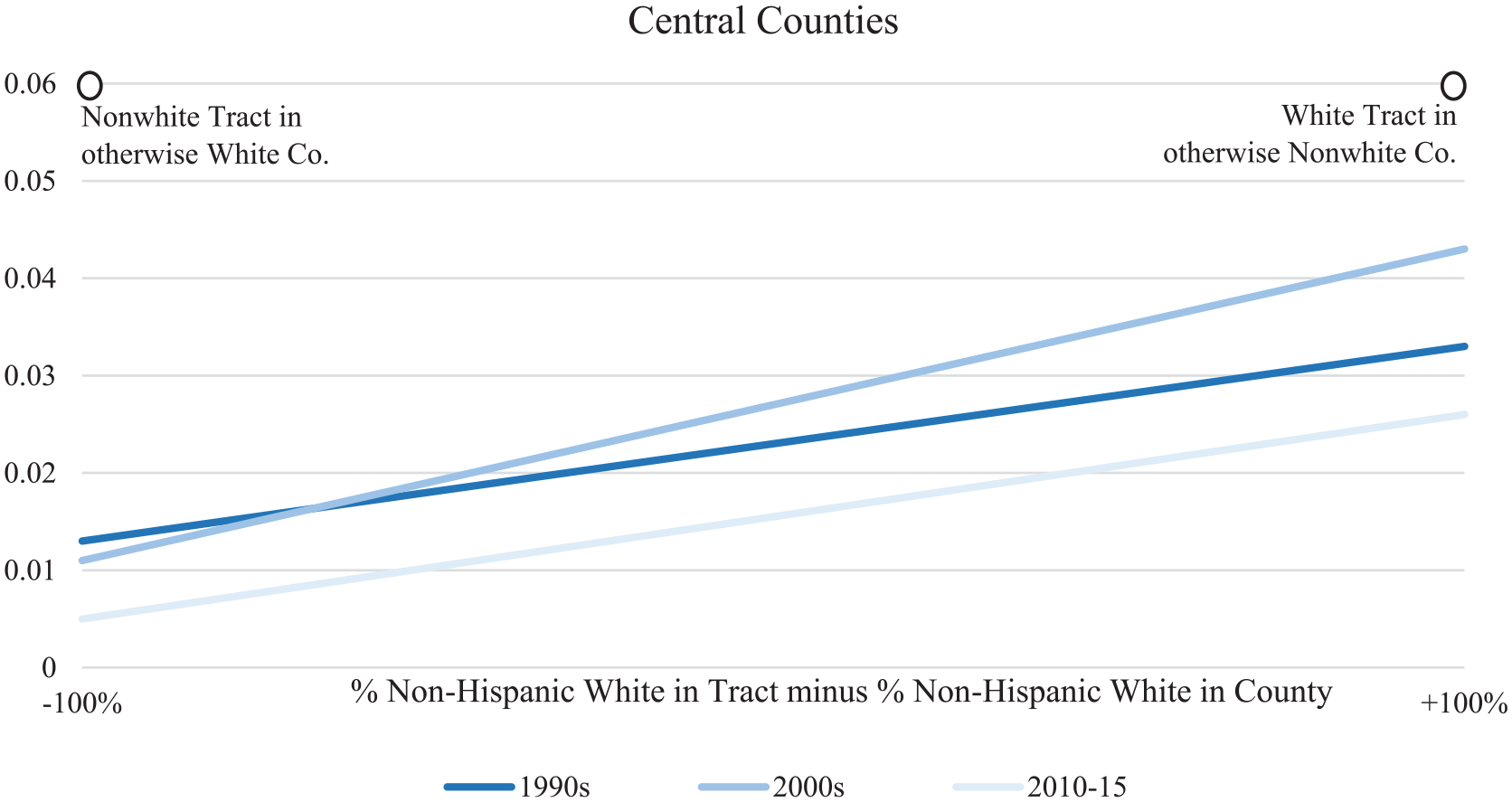
Predicted probability of a census tract’s participating in a Federal Emergency Management Agency–funded buyout program by the proportion of (non-Hispanic) white residents relative to the county, by decade for central counties only.
The Number of Buyouts in Participating Neighborhoods
Next, we examine the number of buyouts that occur in a tract, conditional on that tract experiencing at least one buyout. We use this conditional approach because no nationwide data exist on the number of households eligible for buyouts; they exist only for buyouts that actually occurred. Low buyout numbers in neighborhoods, however, do not necessarily mean low numbers of eligible households. In Houston during the early 2010s, for example, the Harris County Flood Control District sought to buy out more than 800 properties in a neighborhood but ended up purchasing only 10 (Lynn 2017:952).
Note, that as our analysis shifts toward buyout counts, the hypothesis about white privilege also shifts. The logic is that although white privilege may elevate the probability of being extended government assistance, especially in highly urbanized areas, it simultaneously reduces the likelihood of homeowners’ feeling compelled to accept that assistance. By contrast, in historically minority neighborhoods, lower market demand and home values are likely to leave flood-prone homeowners with fewer options other than to accept a government buyout.
To test this hypothesis, we estimated a series of regression equations like the ones presented earlier but with a couple of changes. First and as noted earlier, we now focus only on tracts where buyouts occurred, which is our proxy for neighborhood eligibility. Then, we use negative binomial regression to estimate the number of buyouts that were actually accepted, controlling for the number of housing units and median housing value in the tract. (We no longer control for county-level flood damage because we assume that factor influences whether a county participates in the buyout program and how many neighborhoods are targeted, not how many homeowners actually accept a buyout in an eligible neighborhood.)
The results appear in Table 3 and point to several key findings. First, our racial hypothesis is supported but again only in central counties, not in suburban or nonmetropolitan counties. Second, this support is present during the 1990s and 2000s but reverses from 2010 to 2015. During the 1990s, for example, calculations (not shown) predict that all else equal, a tract that is 80 percent nonwhite in a county that is 80 percent white would be expected to have 21 homeowners accept buyouts. If the scenario were reversed and the tract were 80 percent white in a county that was 80 percent nonwhite, we would expect just 6 homeowners to accept buyouts, more than a threefold difference, all else equal. For the 2000s, the predicted counts would be 12 and 5, respectively.
Negative Binomial Regression Results Predicting the Number of Buyouts That Occur in a Tract, by Type of County and Decade.

Note: Sample includes only “eligible” tracts, defined as those with at least one buyout during the respective time period. Values in parentheses are standard errors.
The spatial lag is computed using a queen-1 contiguity weights matrix. The variable is coded 1 if any adjacent tract had a Federal Emergency Management Agency–funded buyout during the respective period; otherwise, the value is 0.
p < .05. **p < .01. ***p < .001.
One reason for the reversal within central counties from 2010 to 2015 might be that the period is dominated by buyouts in New York and New Jersey following Hurricane Sandy in 2012, and that case is simply different (see Douglas, Koslov, and Klinenberg 2015; Faber 2015). To test that possibility, we reestimated our model for 2010 to 2015 separately for central counties in New York and New Jersey versus elsewhere. The results appear in Table 4, with and without a spatial lag, and indicate the following. In New York and New Jersey, the white composition of a tract relative to its county correlates strongly positively with the number of buyouts when no spatial lag is included in the model. Calculations (not shown) predict that all else equal, a tract that is 80 percent nonwhite in a county that is 80 percent white would have just 3 homeowners accept buyouts. If the scenario were reversed and the tract were 80 percent white in a county that was 80 percent nonwhite, we would expect nearly 72 homeowners to accept buyouts. That is a radical departure not only from earlier decades but from the rest of the United States between 2010 and 2015, as indicated by the nonsignificant, comparator results in Table 4.
Negative Binomial Regression Results Predicting the Number of Buyouts That Occur in Participating Central-County Tracts from 2010 to 2015, by Location in or Not in New York and New Jersey.
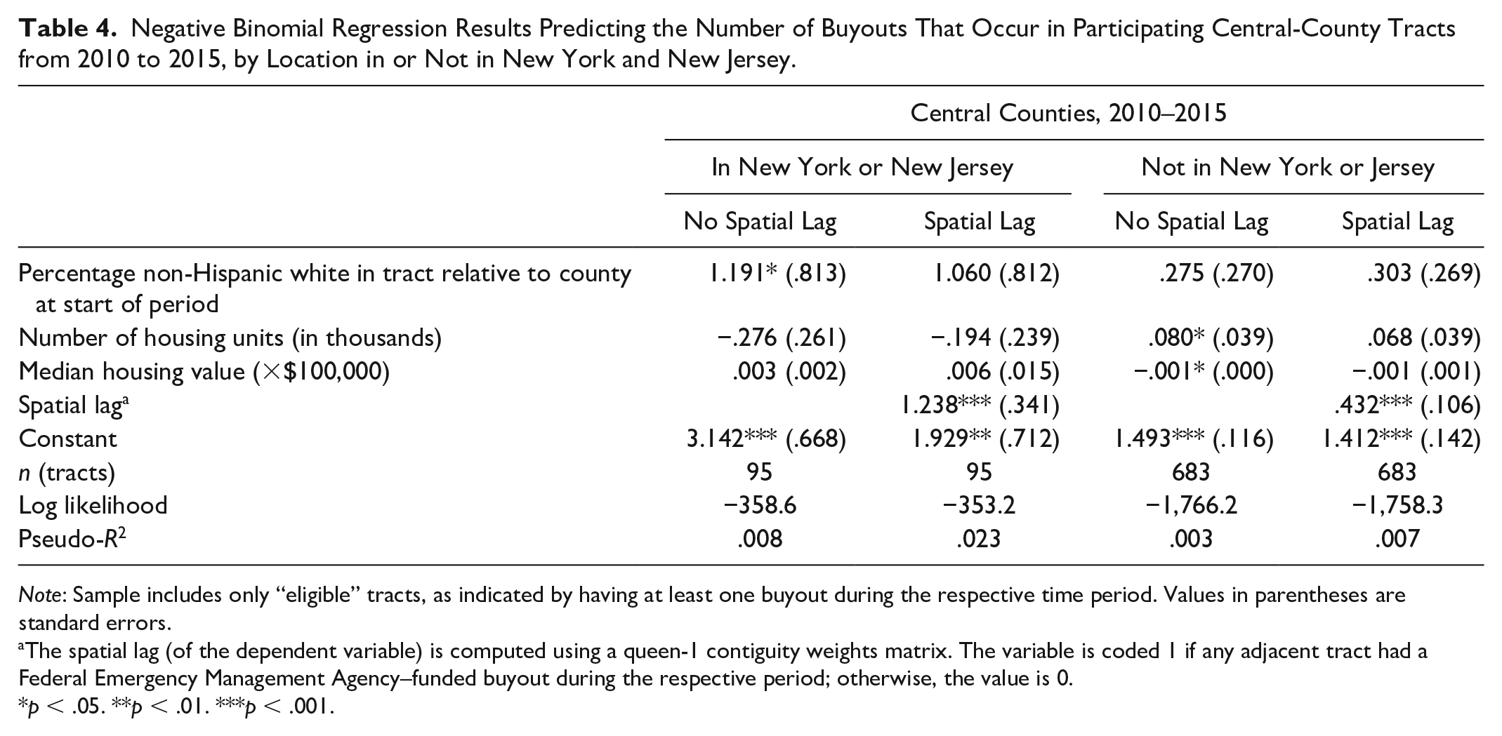
Note: Sample includes only “eligible” tracts, as indicated by having at least one buyout during the respective time period. Values in parentheses are standard errors.
The spatial lag (of the dependent variable) is computed using a queen-1 contiguity weights matrix. The variable is coded 1 if any adjacent tract had a Federal Emergency Management Agency–funded buyout during the respective period; otherwise, the value is 0.
p < .05. **p < .01. ***p < .001.
Next, Table 4 shows that once we include the spatial lag (to control for the spatial clustering of eligible tracts) in New York and New Jersey, the strongly positive effect of racial composition becomes statistically nonsignificant. The implication of this shift is not that the relative whiteness of a tract’s population failed to predict the number of buyouts that occurred after Hurricane Sandy. Instead, it is that the tracts where that effect was strongest were geographically proximate. The racialized process, in other words, was not contained within specific tracts but rather scaled up to larger community boundaries in which those tracts were clustered.
Conclusion
With so much threatened by the rising waters of tomorrow, the federal government’s purchase, demolition, and return to nature of existing homes is now considered by many to be a key policy tool for managing the steady retreat of people from areas of future flooding. For that reason alone it deserves social scientific investigation. In the present study, we began our investigation by situating the policy within the federal government’s long history of flood control to illuminate how such efforts never really end; instead, they keep building on what came before. In those successive socioenvironmental interventions, government officials are understandably eager to emphasize the technical and economic rationality of their efforts to defuse charges of undue racial bias. But when housing is the ultimate target, such bias can be difficult to suppress, especially in urban areas. This is true not only because cities have more people and money than other places, giving them greater government capacity to pursue federally backed buyouts (see Mach et al. 2019). It is also because cities have neighborhoods forged through long histories of racial segregation that live on to create unequal access to opportunities in good times and bad, as well as in ways that can accumulate across multiple of steps of housing transactions, even when the buyer is a government agency. To test for such inequities we followed the demographic trail through respective scales of the buyout process to produce the first nationwide study focused specifically on racial disparities.
What did we find? First, despite its rural origins, the federal buyout policy has evolved into an urban buyout policy, with three quarters of completed transactions to date occurring in the central counties of metropolitan areas. Second, in those central counties, flood damage is not the only predictor of where buyouts occur. Racial composition matters too. It starts with whiter central counties and relatively whiter neighborhoods within those counties being more likely to gain access to federal buyout assistance. It ends with homeowners in neighborhoods of color being more likely to accept that assistance, making nonwhite neighborhoods in otherwise white counties the areas of greatest demolition, statistically. Although the latter finding is robust, it is not monolithic, as more recent years and the case of New York and New Jersey after Hurricane Sandy illustrate.
Why might that be the case? One reason could be that, as Koslov (2016) documents, the buyout process played out differently after Hurricane Sandy. Instead of voluntary acts undertaken by individual homeowners, the program became a fountain of collective action in places such as Staten Island and along the Jersey shore, where white working- and middle-class residents organized to lobby for buyouts of entire communities. In those cases, white privilege not only helped secure that assistance, it also nurtured community sentiments that framed the future in terms of two intersecting communal threats: flooding and gentrification. Mass buyouts addressed both concerns by allowing threatened homeowners to hand their community back to nature rather than to wealthy newcomers. Around that same time, a quite different scenario was unfolding in the historically black neighborhood of Kashmere Gardens in Houston, another leader in the federal buyout program. There, as Lynn (2017) documented, residents and community leaders rallied to suppress local buyout offers, which were framed as a new type of urban renewal looking to remove black residents from their neighborhoods.
What do these findings imply for the future? Here, we are on more speculative ground. But overall and to start, it seems unlikely that the federal buyout program will shake its urban bias anytime soon. Central counties of metropolitan areas are simply where the benefits of managed retreat are greatest, and thus they will be where the policy is likely to continue to focus. This reality is both rational and racial because it involves intervening in neighborhoods long crosscut by racial inequities. To think otherwise is to ignore not only history but the government’s role in its racialized unfolding in urban areas. That racialization is now occurring in new ways that provide more opportunities to whiter communities to participate in the latest wave of federal flood mitigation, while leaving neighborhoods of color more likely either to consent or face future flood risks. This dynamic is not a contradiction. It is how privilege seems to work in the age of climate change (Norgaard 2012; Siders 2019). It brings more options and public resources to those living in more socially advantaged spaces, especially if they own property, while leaving those in socially marginalized spaces more reliant on government assistance that is not only less likely to come but less trusted when it does.
Looking ahead, these racial dynamics are likely to make an already complicated situation even more complicated, especially if they are ignored. To rely strictly on benefit-cost ratios and presumptions of individualized property rights to cut through that complexity would be wishful thinking not only in inner-city neighborhoods but also for tribal communities, where collective relocation “is an absolute, non-negotiable priority for most people” (Marino 2018:12). Communal, racialized politics, in other words, are likely to become a growing feature of the national buyout program, proclamations of rational implementation notwithstanding.
These are informed speculations grounded in findings from the present study. They are not set in stone. One thing, however, does seem certain. We need more research by social scientists in this arena, and the goal should not be to prove or disprove the rationality of new mitigation policies but rather to break them down into their constituent parts to investigate how and where racial and other social inequities also enter and accumulate in their local implementations. In this effort, we need to take flood control more seriously as a state-led process that organizes social space, much in the way past scholarship has considered the construction of public housing and highways during past periods of urban redevelopment and change (Hirsch 1983; Shelton 2017). This process has several historical permutations in the United States, beginning with the use of large-scale engineering infrastructure in the 1920s and continuing through the use of flood insurance in the 1960s and mitigation in the 1980s, three processes that continue in the present. Although each mode of flood control has its own history, politics, and sets of technical expertise, over time they have come to work, if not in concert, then in parallel and at different scales as cities and regions attempt to solve the challenges of their ever changing environments. We look forward to that important and ongoing line of research.
Footnotes
Appendix
County-Level Descriptive Statistics (N = 3,143).

| Variable | Mean | SD | Minimum | Maximum |
|---|---|---|---|---|
| Buyout participation (0 = no, 1 = yes) | ||||
| 1990s | .23 | 0 | 1 | |
| 2000 | .19 | 0 | 1 | |
| 2010–2015 | .12 | 0 | 1 | |
| Percentage non-Hispanic white | ||||
| 1990 | .85 | .18 | .03 | 1.00 |
| 2000 | .81 | .19 | .02 | 1.00 |
| 2010 | .78 | .20 | .03 | .99 |
| Flood damage (×$1 billion) a | ||||
| 1990s | 3.64 | .30 | .00 | 150.0 |
| 2000s | 2.40 | .19 | .00 | 69.4 |
| 2010–2015 | 4.77 | .93 | .00 | 392.0 |
| Population (in millions) | ||||
| 1990 | .88 | .89 | .00 | 12.7 |
| 2000 | .98 | .99 | .00 | 10.6 |
| 2010 | 1.06 | 1.11 | .00 | 13.7 |
| Mean household income (×$1,000) | ||||
| 1990 | 66.05 | 72.93 | 1.00 | 121.01 |
| 2000 | 95.78 | 98.72 | 9.00 | 122.08 |
| 2010 | 118.05 | 123.01 | 12.22 | 139.06 |
| County type b | ||||
| Central | .40 | 0 | 1 | |
| Suburban | .42 | 0 | 1 | |
| Nonmetropolitan | .18 | 0 | 1 |
Source: Full-count census data for 1990 and 2000; American Community Survey data for 2010.
Adjusted to 2015 dollars to control for inflation.
As designated by the Office of Management and Budget in 2015.
1
2
Voluntary decision making by a homeowner about whether to accept a buyout, once offered, is a federal rule. If a flood control district opts out of federal funding, it can exercise eminent domain if it chooses.
3
For online designations and county crosswalks, see https://www.nber.org/data/cbsa-fips-county-crosswalk.html and ![]() .
.