
Abstract
This article traces the spatial history of New York City’s geographic school subdistrict boundaries throughout the 20th century, exploring the historical relationship between race, space, and schooling in New York City and beyond. It seeks to both make the case for studying the spatial history of within-district education boundaries and put the results of our historical mapping project into the public domain. Ultimately, we hope that researchers will use our data to explore their own questions about the history of New York City, its neighborhoods, and its schools, and that some may embark on similar boundary-mapping projects for other cities, counties, and school systems.
Boundaries, by definition, divide. They separate space and people, and, in the context of schooling, they function as the foundation on which physical and institutional structures of educational inequality are built. As Genevieve Siegel-Hawley (2016) writes, “At the most basic level, once a geographic area defined by a boundary gains a name, it also gains a demographic identity,” often demarcating and reifying racial and economic segregation by determining access and justifying exclusion (p. 12). Studying how educational boundaries have been created, maintained, and altered can thus reveal a great deal about the construction of educational inequality (or, alternatively, its reduction), as well as the relationship between schooling and spatial development.
The importance of educational boundaries has not been lost on historians of U.S. education, many of whom have documented the myriad ways in which city, suburban, and county planners have drawn boundaries to both promote and reflect racial, ethnic, and economic school segregation (Benjamin, 2012; Dougherty, 2012; Garcia, 2018; Highsmith & Erickson, 2015; Kelly, 2020; Rury, 2020). Most existing historical scholarship that examines school and district boundaries in the United States explores documented discussions about where and how to draw boundary lines at particular moments in time—often highlighting pivotal junctures in the past that set the stage for today’s spatial and educational inequalities, and at times also marking histories of resistance, community-based organizing, and moments of expanded inclusion and access (Hodge, 2018; Perlstein, 2004). Boundary lines are not drawn on a blank canvas, however; they represent either an acknowledgement of existing spatial distinctions or an intentional break from the past. Tracing the evolution of school and district boundary lines through time and context can thus offer greater understandings of today’s spatial patterns, divisions, and inequalities. Moreover, as Matthew Kelly (2019) has pointed out, historicizing education boundaries and making their seemingly imaginary lines visible can also help researchers identify new, concrete questions to ask of the past.
In the United States, there are two primary forms of educational boundaries. School district boundaries often separate tax bases and access to financial resources, dividing the “haves” from the “have nots” and criminalizing families if they seek an education for their children across a boundary line (Rooks, 2017). Within-district boundaries, on the other hand, do not usually indicate divisions based on distinct governmental units or tax bases. Instead, within-district boundaries, such as school enrollment zones or subdistrict lines, serve primarily to divide from within, creating or affirming “neighborhood” or other place-related identities that determine enrollment and ultimately the racial, ethnic, and socioeconomic composition of individual schools and subdistricts. Within-district boundary lines tend to be less rigid than those separating districts and perhaps as such leave a smaller historical footprint. Yet within-district boundaries also produce spatial distinctions that often prove durable—even in the face of reforms seeking to undo them (Buendía et al., 2004). Thus, while at times difficult to identify, documenting the evolution of within-district education boundaries can be a powerful tool for exploring the history of educational access and exclusion within larger school systems.
This article has two purposes. First, in sharing our experience identifying and mapping the evolution of geographic school subdistrict boundaries in New York City since the beginning of the 20th century, we seek to make the case for studying the spatial history of within-district education boundaries. We offer examples from the borough of Brooklyn to demonstrate how using geospatial information system (GIS) software as a tool for both visually representing subdistrict boundary lines through time and examining those lines alongside other forms of shifting spatial data can help illuminate, or at least raise questions about, the historical relationship between race, space, and schooling. Understanding the historical and political roots of today’s subdistrict school boundaries may also help inform current deliberations aimed at rethinking them. Second, we use this article to put our data and maps of New York City’s school subdistrict boundaries from 1902 through today into the public domain so that other researchers may use them to explore their own questions about the history of New York City, its neighborhoods, and its schools, and to perhaps identify new questions for further research.
In the following sections, we first explain why we think tracing the evolution of New York City’s geographic school subdistrict boundaries through time is important. We then briefly describe how we identified those boundaries and used GIS software to create maps and prepare them for public use (we include greater detail about our methods in online Appendix A). Finally, we use examples from the borough of Brooklyn to demonstrate how our mapping project, and others like it, can help reveal the historical relationships between schooling and the spatial and racial construction of neighborhoods and municipalities. Ultimately, we hope that scholars will find our maps and data useful for their own work on New York City and its schools, and that researchers will embark on similar boundary-mapping projects for other cities, counties, and school systems.
Why Study New York City’s School Subdistrict Boundaries?
School subdistrict boundaries are unique to large education systems. They are not the same as attendance zones or catchment boundaries, which determine which children attend which schools based on where they live. But school subdistrict boundaries are also not district boundaries in the traditional sense in that they do not separate tax bases or divide space into unique or distinct municipal units. School subdistricts exist within centralized systems that share many governance features and, importantly, sources of funding. Yet sub“districts” often function as administrative units with control over certain aspects of local schooling. Moreover, boundary lines distinguishing one geographic school subdistrict from another can serve additional organizational and political purposes: Students are often required to attend schools within their geographic subdistrict, and parents and citizens can be expected to direct their school-related views and concerns to local school subdistrict authorities. Thus, school subdistrict boundary lines can play an important role in determining educational inclusion and access, as well as creating and/or dividing spatially identifiable communities.
New York City’s public school system is divided into 32 geographic “community school districts” composed of most of the city’s elementary and middle schools (most high schools are organized into separate subdistricts; see Figure 1). The boundaries of these school subdistricts were drawn half a century ago, in the aftermath of a brief experiment with community control and a subsequent protracted teachers’ strike that led to the passage of a state bill decentralizing some aspects of New York City school governance in 1969. Decentralization created local school boards for each of the city’s geographic school subdistricts and granted the boards authority over some school policy decisions, including the hiring of local superintendents and determining school enrollment zones (Lewis, 2013; Podair, 2004). Although the New York City public education system was recentralized in 2002, when the state granted the city mayoral control over its schools, the geographic subdistricts and their boundaries remain in place and continue to spatially divide the city and its families and schools.

New York City’s school district boundaries: Geographic subdistricts, 2021.
While today’s school subdistrict boundaries were mostly established in the late 1960s, their historical roots are much older, dating back to the beginning of the 20th century, when New York City as we know it today was formed by consolidating what are now the five boroughs—the Bronx, Brooklyn, Manhattan, Queens, and Staten Island—into one unit. In 1902, a centralized board of education took control of the entire city school system, which was divided into 46 geographic school subdistricts, each with their own local board and administrator (Ment, 1975; Palmer, 1905). The role of New York City’s subdistricts has shifted since 1902, as have their number and boundaries, but the subdistricts have always been crucial to the organization of the city’s school system. Not only have New York City’s school subdistricts often determined which students could enroll in a specific subset of schools, but those with decision-making authority within school subdistricts (including, at various moments, subdistrict superintendents and/or local board members) also determined school attendance zones as well as other enrollment-related policies (e.g., establishing choice-based programs or desegregation plans), thereby controlling educational access within subdistrict boundaries. 1 Indeed, although prior to decentralization critics often complained about their lack of real authority and/or accountability, membership on New York City’s local (subdistrict) school boards was often contested precisely because the boards were seen as politically important, even if at times administratively weak (Ravitch, 1974; Rogers, 1968).
In practical terms, New York City’s school subdistrict boundaries matter today in two key ways. First, an overwhelming majority of New York City’s public school students attend Grades K–8 within their geographic school subdistrict, even as an increasing number use choice mechanisms to attend a school other than their neighborhood option (School Diversity Advisory Group, 2019). 2 This means that subdistrict boundaries largely determine educational access and can shore up inequalities when some districts have more so-called “high performing” schools, teaching resources, and enrichment opportunities than others (Holzman, 2013). Moreover, because many parts of New York City are racially, ethnically, and socioeconomically segregated, geographic school subdistricts are often segregated as well: While some school subdistricts are demographically diverse, others feature high concentrations of poverty and enroll student populations that are almost entirely Black and/or Latino—rendering within subdistrict school desegregation efforts futile (Cohen, 2021; School Diversity Advisory Group, 2019; see Figure 2).
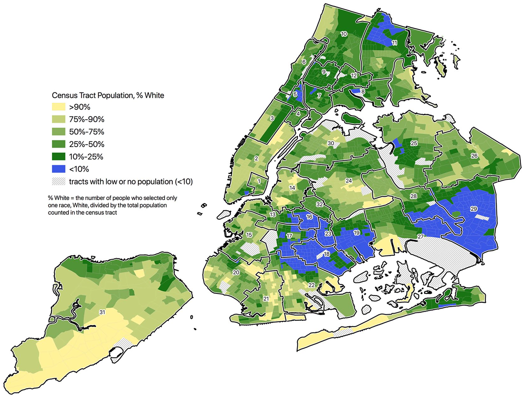
New York City’s school district boundaries: Geographic subdistricts and segregation by race, 2010.
Second, localized politics within New York City school subdistricts can still vary in ways that have a material effect on students’ educational experiences and access. While the governance functions of the elected local (subdistrict) school boards have been virtually eliminated under mayoral control, these bodies, currently called “Community Education Councils,” advise subdistrict administrators and the centralized New York City Department of Education (NYCDOE) on local school policies—especially in relation to school enrollment, siting, and zoning. On the one hand, this structure has allowed White residents and policymakers substantive control in racially diverse subdistricts, where they have often dominated local leadership positions and enacted a racialized politics of exclusion from within by implementing policies that privilege the interests and opportunities of White families (Fruchter, 2021). On the other hand, some school subdistricts have enacted equity-related reforms within their boundaries, such as changing school assignment procedures or supporting expanded enrichment opportunities. Thus, students’ access to an integrated school, for example, or a program designated as “Gifted and Talented,” can often depend on the subdistrict in which they reside.
Yet despite their longevity and continued importance, the origins of New York City’s geographic school subdistricts and their boundaries have never been adequately studied. We argue that scholars, activists, policymakers, and general citizens interested in understanding the construction of educational inequality in New York City (as well as the potential for equity-based reform) must consider the history of the city’s school subdistrict boundaries and their evolution through time, and in relation to the racial and spatial history of New York.
Our decision to document and then digitally map the evolution of New York City’s school subdistrict boundaries since 1902 grew out of our research on the history of schooling in Brooklyn. As we sought to both make sense of the neighborhood and subdistrict distinctions we encountered in archival sources and better understand how city and school planners made decisions about school siting and enrollment policies, we realized that we needed a record of the school subdistrict boundaries as they changed through time, as well as the ability to examine those boundaries in the context of additional spatial data, such as population distribution, land development, other municipal boundaries, and so on. Although our research focus is on Brooklyn, the data and maps we present with this article encompass the entire city because we believe that our findings will be of interest to others, even as the spatial histories of schooling in Manhattan, Queens, the Bronx, and Staten Island are beyond the scope of our own research (see online Appendix B for digitized maps).
When we undertook this mapping project, a series of questions about the relationship between school subdistrict boundaries and the spatial and racial development of the city drove our work. Would we find that subdistrict boundaries had been drawn to reflect existing neighborhood arrangements or to shape them? Would clear patterns of racial, ethnic, and economic segregation appear as subdistrict lines were drawn and redrawn through time, or would we identify possibilities for intradistrict school integration that had never been seized? Would we find constancy, moments of disjuncture, or would no clear narrative emerge? At this point, the tentative answer to most of our questions is “yes”; our work suggests that the evolution of school subdistrict boundary lines in New York City has been as varied and idiosyncratic as the city itself.
We do not attempt a full analysis of the city’s—or even Brooklyn’s—school subdistrict boundaries in this short article. Rather, we offer some examples from Brooklyn to illustrate how our data and maps can be of use to researchers interested in the history of New York City, its neighborhoods, and its schools. Before doing so, however, we first briefly describe how we identified, collected, and then mapped these boundaries through time, so that researchers interested in using our data and maps, and/or replicating our project in other settings, will understand our methods. 3
Mapping Boundaries: Locating, Creating, and Digitizing Data
To map the evolution of New York City’s geographic school subdistrict boundaries through time, we first had to locate and identify information about the boundaries and then digitize that data. We used written verbal descriptions of New York City’s geographic school subdistrict boundary lines to create our data set, beginning with the completion of the school system’s consolidation in 1902. These descriptions, which we found in the New York City Board of Education school directories, list the streets, rail lines, municipal bounds (e.g., “city line”), or natural features (e.g., “East River”) that make up the boundary of each school geographic subdistrict. Once we located this data, our next step was to digitize the written descriptions and note the years when subdistrict boundaries changed. Since the directories do not explicitly mark boundary changes, we compared the written descriptions from one year to the next to identify differences.
Next, we mapped our digitized data with QGIS version 3.4, an open source geographical information systems program. We used a digitized version of the current street map of New York City as a base layer, along with several historical street maps as reference points when necessary. Mapping the boundary descriptions revealed that our initial comparisons only provided a rough approximation of change over time, as sometimes an apparent boundary change in the description really just reflected a street name change, while other times a slight change in description resulted in a very differently shaped subdistrict. In addition, in some instances, the maps revealed clear mistakes in the boundaries—for example, when districts overlapped, or gaps appeared—that were corrected in later versions. We ultimately created 11 digitized maps of New York City geographic school subdistrict boundary lines covering the period from 1902 through today, providing a map for every decade until the 1960s, when, because of multiple changes during those years, we created five maps (see online Appendix B; an interactive version of our maps can be found at https://qgiscloud.com/cicimath/Kafka_Matheny_NYC_School_Subdistrict_Boundaries/). Our final map is from 1975, reflecting the last time New York City’s school subdistrict boundaries were changed (primarily entailing the creation of a new subdistrict in the Bushwick neighborhood of Brooklyn and subsequently modifying surrounding subdistrict boundaries). For more specific information about our data collection, transformation, and mapping methods, see online Appendix A.
With the subdistrict boundaries digitized and mapped, we can more easily observe change through time, and, perhaps even more importantly, we can explore those changes alongside other forms of spatial data, including population distribution, racial geography, land-use and development, housing, local electoral districts, and so on. In short, our digitized maps allow us and other researchers to begin to analyze the city’s school subdistrict boundaries in context and to raise new questions about the purpose and function of those boundaries in relation to the racial, ethnic, economic, and spatial history of New York City.
Examples From Brooklyn: Race, Space, and School Subdistrict Boundaries
As we mentioned earlier, our interest in mapping the evolution of school subdistrict boundaries in New York City grew out of a project we’re conducting on the history of schooling in Brooklyn and its relationship to the borough’s spatial development. We are particularly interested in the ways schools have been used to affirm or challenge racial, ethnic, and economic inequality through various means of expanding and/or limiting educational access. Historians have explored the history of racial and ethnic segregation in Brooklyn, and specifically how actions by federal, state and city agencies, local banks and lenders, real estate agents, and White political leaders and residents led to the increasing concentration of Black and Puerto Rican families and individuals in central and eastern Brooklyn in the middle decades of the 20th century (Connolly, 1977; Pritchett, 2002; Thabit, 2003; Wilder, 2000; Woodworth, 2016). Yet this rich historiography makes little mention of schooling prior to the community control movement of the 1960s (for one exception, see Wellman, 2014). At the same time, historical scholarship on schools in Brooklyn does not tend to address the borough’s spatial development, and the few studies that do consider residential segregation in relation to schooling mostly focus on individual enrollment boundaries rather than the city’s broader geography (Back, 2001; Rieder, 1985). Even the substantial historiography of battles over community control in 1960s Brooklyn rarely considers the borough’s spatial development beyond the few blocks of the Ocean Hill–Brownsville experimental subdistrict where most of those battles played out (Perillo, 2012; Perlstein, 2004; Podair, 2004; Taylor, 2001). Thus, the origins and history of Brooklyn’s school subdistrict boundaries have remained relatively unexamined, even as they still function today to spatially divide the borough and its schools, students, and families.
As we set out to uncover the historical roots of Brooklyn’s school subdistrict boundaries, we had both descriptive questions about their evolution and analytic queries about their relationship to the spatial development of the borough. Descriptively, we wanted to identify former school subdistrict boundaries as well as when and how they changed (or didn’t) through time. Analytically, we were curious to see if Brooklyn’s school subdistrict boundaries aligned with racialized and/or class-based neighborhood characteristics at different historical moments, and if there were any clear patterns or disjunctures in how the subdistricts were spatially organized. Would we find that school subdistrict boundaries shifted to reflect changes in the racial, ethnic, and socioeconomic population in certain areas? Did school subdistrict boundaries instead anticipate, or even advance, demographic changes? Or would no pattern emerge? We also wanted to see how school subdistrict boundaries might correlate with other forms of spatial division—such as election districts, unofficial neighborhood designations, and so on—and how such relationships (or lack thereof) may have shaped subdistricts’ characteristics and the educational opportunities for students within them. Our purpose in this article is not to resolve our questions but to illustrate how our data and maps can help us (and others) begin to answer them, as well as to identify new questions to pursue about race, space, and schooling in New York City.
Constancy and Change in Subdistrict Boundaries
Descriptively, our first question was about the historical roots of today’s school subdistrict boundaries, most of which were established in 1970 (with some modifications in 1973). 4 We knew that in 1969 an interim school board was appointed to create new subdistrict boundaries as part of New York City’s school decentralization. We also knew that after some public debate—mostly about the size and number of geographic subdistricts in Manhattan and the fate of the community control experimental subdistrict in Brooklyn—the boundaries the interim board produced were fairly similar to those already in existence. This was because, in response to the state’s somewhat contradictory order to develop subdistricts that would not only promote “heterogeneity (ethnic and socioeconomic mixture) of pupil populations” but also respect existing geographic continuities, school planning, and specific community needs, the board had chosen to maintain existing school subdistrict boundaries as much as possible (New York City Office of Education Affairs, 1969, n.p; see also, Bresnick, 1972). What remained in question, however, was the origins of the school subdistrict boundaries the interim board sought to maintain, how long those boundaries had been in existence, how much they differed from what had preceded them, and on what basis, by whom, and in what context those earlier boundaries had been drawn.
Our data collection and subsequent maps revealed that the city went through many school subdistrict boundary changes in the 1960s alone but that even with these numerous alterations many constancies remained. For example, in 1962, in response to a series of scandals involving the New York City Board of Education that ultimately led to increased state oversight and an effort to strengthen the power of the “local” school boards while decreasing their number, the city’s 53 geographic school subdistricts were reduced by nearly half (Ravitch, 1974; Rogers, 1968). For the most part, as illustrated in Figure 3, these larger geographic school subdistricts were created by consolidating existing school subdistricts while maintaining their boundaries. Thus, for instance, while the boundary between Districts 26 and 28 in Brooklyn was eliminated, the rest of their boundary lines remained the same.

New York City’s school district boundaries: Consolidation of geographic subdistricts of Brooklyn.
In fact, despite the many school subdistrict boundary changes we documented from 1902 through 1974, we were surprised by the degree of stability we found in some of Brooklyn’s school subdistrict boundaries. For instance, while small boundary modifications occurred through the years, our mapping demonstrates that the overall geography of today’s District 15, which encompasses some of modern-day Brooklyn’s wealthiest and Whitest neighborhoods (including Cobble Hill and Park Slope) as well as more working-class and high-poverty areas (including Sunset Park and Red Hook), was first established in 1902, and that many of the subdistrict’s boundaries have remained unchanged since 1920 (although initially as boundaries of two contiguous subdistricts; see Figure 4). The northern border of the subdistrict did flip back and forth a bit in the 1960s, and became a point of contention in the 1970s, as some White families living in Brooklyn Heights sought unsuccessfully to expand District 15 to include their homes, arguing that the subdistrict boundary arbitrarily divided their neighborhood and that they did not “desire” to send their children to school in District 13 (a subdistrict with fewer White students and less affluence than District 15 at the time; Maeroff, 1974). The subdistrict’s general shape, however, was relatively stable throughout the century, demonstrating that its historical roots long preceded the tumultuous 1960s, as well as postwar migration and the early gentrification of many of Brooklyn’s tonier neighborhoods (Osman, 2011).

Brooklyn’s District 15: Origins and consistency over time.
The continuities we identified in some school subdistrict boundaries and general geographies raise many questions for us: Why were some geographic subdistricts so stable while others underwent repeated changes? What effect might the steadiness of some school subdistrict boundaries have had on the educational and spatial development that occurred within them? How did the growth of publicly subsidized housing for low-income and middle-class residents influence school subdistrict boundaries? We know that in the context of political arguments over both racial integration and community control, some of Brooklyn’s school subdistrict boundary changes were contentious and others were at least publicly debated, but what do we make of the quiet constancy that shaped many of the school subdistricts that are still in place today? While additional spatial data cannot answer all of our questions, looking at the subdistrict boundaries in relationship to factors such as racial and ethnic population distribution, land development, housing patterns and regulations, local politics, and so on can point to avenues for further inquiry.
Population Distribution in School Subdistrict Boundaries
Data from the U.S. Census Bureau is a useful place to begin to explore population distribution in relation to school subdistrict boundaries. One might examine population density and growth in certain areas, or compare the school-aged population in different subdistricts at various moments with actual school enrollment data, or explore social class indicators such as adults’ occupations or education levels across subdistricts. Here we use census data to examine the racial and ethnic composition of Brooklyn’s school subdistricts across time. Census data proves somewhat problematic when trying to account for New York City’s Puerto Rican population, which grew considerably in the postwar era but was not distinguished by the census until 1960, when the category “Puerto Rican or Spanish Surname Population” was added, and then changed to “Spanish American Persons” in the 1970 Census. 5 Even with these limitations, however, mapping the evolution of school subdistrict boundary changes through time in Brooklyn in relation to the racial and ethnic spatial distribution of the borough’s population as recorded by the census indicates that Black, Puerto Rican (and later other Latinx) students were concentrated in several geographic school subdistricts for much of the postwar era. In Figure 5, we show this demographic transition across three decades, visually representing the proportion of each census tract that was White in relation to shifts in the school subdistrict boundaries. 6

New York City’s school district boundaries: Geographic subdistricts of Brooklyn and population data, 1950–1970.
At the same time, while our maps make this history visual, they also raise additional historical questions about the relationship between educational and residential segregation in Brooklyn, as well as about the political process by which the city’s school subdistricts were constituted and maintained. For example, when we examine which subdistricts were consolidated with each other in 1962 in relation to the racial and ethnic distribution of Brooklyn’s population, a pattern emerges, as some subdistricts appear to have become increasingly racially segregated over the years that followed. This pattern raises numerous questions: Who chose which geographic subdistricts to combine in 1962, and how were those decisions made? 7 Did the subdistrict boundaries help usher in increased residential segregation or were the boundaries drawn to reflect existing trends? The combined subdistricts shared an assistant superintendent prior to their consolidation, suggesting that the subdistricts were already administratively paired (Bresnick, 1972; New York City Board of Education, n.d.). But this finding also raises questions about how that administrative decision was made: Who decided which subdistricts should be grouped together under one centralized administrator, and what did those pairings in turn signify about the way in which the Board of Education perceived the spatial relationship between various subdistricts? Because these pairings later became the template for most of the school subdistricts still in place today, questions about their provenance are directly related to the current spatial distribution of schools, students, and families in Brooklyn. Our visual history thus points to avenues for further archival research.
Viewing the evolution of subdistrict boundaries alongside shifts in the racial and ethnic composition of the borough through time also helps us identify specific boundary changes we intend to investigate further. For example, between 1950 and 1960, District 42’s boundaries changed as the neighborhoods known as Brownsville and Canarsie became more distinctly Black/Puerto Rican and White, respectively. As Figure 5 makes clear, this boundary change created a geographically smaller and more Black and Puerto Rican District 42, which was mostly contiguous with the neighborhood known as Brownsville. Meanwhile District 41 expanded to include the overwhelmingly White neighborhoods that had once been part of District 42, most notably the almost entirely White Canarsie. We intend to investigate what led to this subdistrict boundary change, who made the decision, and based on what rationale.
In some ways, the redrawing of the 41/42 boundary represents a brief blip in a longer trajectory, as the two subdistricts were combined in 1962 and that new boundary was removed. Yet its significance was evident years later, when, in 1964, the subdistricts’ Local School Board opposed an integration plan that would have included schools and students from both 41 and 42, citing the importance of maintaining “neighborhood” boundaries (Local School Board Unanimously Nixes Princeton Plan and Cross Bussing, 1964). While these same board members were likely to have opposed an integration plan under any circumstance, the spatial division created by the subdistrict boundary offered an established rationale and suggested that a real and clear distinction existed between the two geographic areas. Indeed, despite the fact that the two subdistricts had technically been combined, they were still referred to as “Districts 41 and 42” by the Board of Education, the local school board, and city newspapers (New York City Board of Education, n.d.). Moreover the (brief) boundary line change also forecast a more permanent spatial division when, in the aftermath of community control, District 23 was created out of much of the same geographic area as the briefly smaller District 42.
Housing Development, Regulations, and School Subdistrict Boundaries
Demographic data provide one way of examining school subdistrict boundaries in relation to the racial and ethnic composition of Brooklyn, but other forms of spatial data offer additional context, particularly about intentional choices on the part of city, state, and federal officials that may have created or enhanced both residential and school segregation and inequality. For example, digitized maps from the Home Owners Loan Corporation (HOLC), the federal agency that rated neighborhoods in the 1930s for mortgage lending purposes and “redlined” areas deemed too risky an investment (often because of their racial or ethnic composition), allow for the examination of HOLC ratings in relation to school subdistrict boundaries. Scholars have demonstrated that redlining had long-term economic consequences for neighborhoods subsequently starved of capital, and often led to rapid residential segregation in areas that had once been racially diverse (Rothstein, 2017; Wilder, 2000). Given that the Federal Housing Authority articulated an interest in preventing school desegregation, however, researchers might also explore the relationship between HOLC neighborhood ratings and subsequent school subdistrict boundaries that helped ensure that schools would remain segregated.
In our own examination of school subdistrict boundaries in Brooklyn, we noticed that HOLC ratings from the 1930s appeared to align with the district mergers that happened decades later, in that subdistricts tended to be combined with bordering subdistricts with similar neighborhood ratings (i.e., subdistricts with redlined neighborhoods were joined together while subdistricts with “second-grade” or “third-grade” neighborhoods were joined together; see Figure 6). This observation raises additional questions in need of further research. Did the HOLC ratings capture or create perceived neighborhood differences? And were school subdistrict boundaries drawn to reflect unofficial neighborhood distinctions or to reinforce them?

New York City’s school district boundaries: Redlining and geographic subdistricts of Brooklyn.
Similarly, maps from the New York City Housing Authority (NYCHA), the state agency that provides public housing in the city, allow us to investigate how the presence of public housing may have helped shape school subdistrict boundary changes through time, as well as how subdistrict boundaries may have influenced the location and/or racial designation of large-scale public housing developments. For example, when investigating the boundary change between subdistricts 41 and 42 that we discussed above, which created a subdistrict for Brownsville and separated the neighborhood from nearby Canarsie, we noticed that in addition to creating a more racially segregated 42, the changed boundary line also circumscribed Brownsville’s large public housing developments, which were designated by NYCHA as “colored projects” even before Brownsville had a significant Black population (Pritchett, 2002). Viewing the school subdistrict boundary change in this context raises additional questions for us about the co-construction of residential and school segregation in Brooklyn during this period. New NYCHA housing could have precipitated the boundary change, since large developments would have increased population density in the area. The boundary change may have also constituted a promise of sorts to White families that their children’s schools would remain segregated despite their proximity to the largescale housing projects. At this point we are speculating, but mapping the school subdistrict boundary lines through time and alongside other forms of spatial data have allowed us to ask new questions and consider the spatial history of Brooklyn’s schools in new ways.
Conclusion
Although state law allows for New York City’s school subdistrict boundaries to be revisited and revised on a regular basis, they have remained unchanged since 1974, despite the fact that some subdistricts have quite large enrollments while others have far fewer than the 15,000 students technically mandated by the state. The last time there was serious debate about altering New York City’s school subdistricts and their boundaries was more than 30 years ago, and even then some civic groups argued that the boundaries had become too entrenched to change and that the subdistricts themselves had “assumed individual identities and governing styles” that should not be disturbed (Buder, 1989). That was before the current system of mayoral control, however, at a time when local boards had greater say in school subdistrict policies and hired their own local superintendents to enact them. Under today’s governance system, the subdistrict boundaries serve little administrative purpose other than to demarcate spatial distinctions that often would not otherwise exist. Changing New York City’s school subdistrict boundaries would require local as well as state political action, which is perhaps why most current proposals for equity-based school reform in the city leave the subdistrict structure untouched (Cohen, 2021; School Diversity Advisory Group, 2019). Our examination of the historical roots of New York City’s school subdistrict boundary lines, however, suggest that such change is not unprecedented, and, if undertaken with an intentional equity focus, could lead to expanded educational opportunity and access for many New York school children.
The two purposes of this article were to share our data and maps tracing the spatial history of New York City’s school subdistrict boundaries and to make a case for the importance of studying that history—both in New York and elsewhere. Within-district education boundaries like those we discuss here are underresearched by historians, perhaps in part because they are often invisible. Yet we have much to gain when boundaries of the past can be documented and mapped across time and in relation to other forms of spatial data. First, tracing both constancy and change in school subdistrict boundaries can reveal the historical roots of today’s educational inequalities as spatially constructed and maintained. Second, making the history of school subdistrict boundaries visible can raise new questions to explore, particularly about the relationship between schooling, race, space, and development. Finally, for scholars, activists, and reformers seeking to reorganize schooling in pursuit of a more equitable distribution of power, resources, and educational outcomes, understanding the process by which within-district school boundaries have been created, redrawn, and/or preserved may point the way to rethinking the political process that still governs educational boundary making today.
Supplemental Material
sj-docx-1-ero-10.1177_23328584211038939 – Supplemental material for Boundary Matters: Uncovering the Hidden History of New York City’s School Subdistrict Lines
Supplemental material, sj-docx-1-ero-10.1177_23328584211038939 for Boundary Matters: Uncovering the Hidden History of New York City’s School Subdistrict Lines by Judith Kafka and Cici Matheny in AERA Open
Supplemental Material
sj-docx-10-ero-10.1177_23328584211038939 – Supplemental material for Boundary Matters: Uncovering the Hidden History of New York City’s School Subdistrict Lines
Supplemental material, sj-docx-10-ero-10.1177_23328584211038939 for Boundary Matters: Uncovering the Hidden History of New York City’s School Subdistrict Lines by Judith Kafka and Cici Matheny in AERA Open
Supplemental Material
sj-docx-11-ero-10.1177_23328584211038939 – Supplemental material for Boundary Matters: Uncovering the Hidden History of New York City’s School Subdistrict Lines
Supplemental material, sj-docx-11-ero-10.1177_23328584211038939 for Boundary Matters: Uncovering the Hidden History of New York City’s School Subdistrict Lines by Judith Kafka and Cici Matheny in AERA Open
Supplemental Material
sj-docx-12-ero-10.1177_23328584211038939 – Supplemental material for Boundary Matters: Uncovering the Hidden History of New York City’s School Subdistrict Lines
Supplemental material, sj-docx-12-ero-10.1177_23328584211038939 for Boundary Matters: Uncovering the Hidden History of New York City’s School Subdistrict Lines by Judith Kafka and Cici Matheny in AERA Open
Supplemental Material
sj-docx-13-ero-10.1177_23328584211038939 – Supplemental material for Boundary Matters: Uncovering the Hidden History of New York City’s School Subdistrict Lines
Supplemental material, sj-docx-13-ero-10.1177_23328584211038939 for Boundary Matters: Uncovering the Hidden History of New York City’s School Subdistrict Lines by Judith Kafka and Cici Matheny in AERA Open
Supplemental Material
sj-docx-2-ero-10.1177_23328584211038939 – Supplemental material for Boundary Matters: Uncovering the Hidden History of New York City’s School Subdistrict Lines
Supplemental material, sj-docx-2-ero-10.1177_23328584211038939 for Boundary Matters: Uncovering the Hidden History of New York City’s School Subdistrict Lines by Judith Kafka and Cici Matheny in AERA Open
Supplemental Material
sj-docx-3-ero-10.1177_23328584211038939 – Supplemental material for Boundary Matters: Uncovering the Hidden History of New York City’s School Subdistrict Lines
Supplemental material, sj-docx-3-ero-10.1177_23328584211038939 for Boundary Matters: Uncovering the Hidden History of New York City’s School Subdistrict Lines by Judith Kafka and Cici Matheny in AERA Open
Supplemental Material
sj-docx-4-ero-10.1177_23328584211038939 – Supplemental material for Boundary Matters: Uncovering the Hidden History of New York City’s School Subdistrict Lines
Supplemental material, sj-docx-4-ero-10.1177_23328584211038939 for Boundary Matters: Uncovering the Hidden History of New York City’s School Subdistrict Lines by Judith Kafka and Cici Matheny in AERA Open
Supplemental Material
sj-docx-5-ero-10.1177_23328584211038939 – Supplemental material for Boundary Matters: Uncovering the Hidden History of New York City’s School Subdistrict Lines
Supplemental material, sj-docx-5-ero-10.1177_23328584211038939 for Boundary Matters: Uncovering the Hidden History of New York City’s School Subdistrict Lines by Judith Kafka and Cici Matheny in AERA Open
Supplemental Material
sj-docx-6-ero-10.1177_23328584211038939 – Supplemental material for Boundary Matters: Uncovering the Hidden History of New York City’s School Subdistrict Lines
Supplemental material, sj-docx-6-ero-10.1177_23328584211038939 for Boundary Matters: Uncovering the Hidden History of New York City’s School Subdistrict Lines by Judith Kafka and Cici Matheny in AERA Open
Supplemental Material
sj-docx-7-ero-10.1177_23328584211038939 – Supplemental material for Boundary Matters: Uncovering the Hidden History of New York City’s School Subdistrict Lines
Supplemental material, sj-docx-7-ero-10.1177_23328584211038939 for Boundary Matters: Uncovering the Hidden History of New York City’s School Subdistrict Lines by Judith Kafka and Cici Matheny in AERA Open
Supplemental Material
sj-docx-8-ero-10.1177_23328584211038939 – Supplemental material for Boundary Matters: Uncovering the Hidden History of New York City’s School Subdistrict Lines
Supplemental material, sj-docx-8-ero-10.1177_23328584211038939 for Boundary Matters: Uncovering the Hidden History of New York City’s School Subdistrict Lines by Judith Kafka and Cici Matheny in AERA Open
Supplemental Material
sj-docx-9-ero-10.1177_23328584211038939 – Supplemental material for Boundary Matters: Uncovering the Hidden History of New York City’s School Subdistrict Lines
Supplemental material, sj-docx-9-ero-10.1177_23328584211038939 for Boundary Matters: Uncovering the Hidden History of New York City’s School Subdistrict Lines by Judith Kafka and Cici Matheny in AERA Open
Footnotes
Acknowledgements
The authors thank Deborah Balk and Frank Donnelly for their methodological and technological guidance, and Heather Lewis, Bethany Rogers, and two anonymous reviewers for their helpful feedback on earlier drafts of this work.
Notes
Authors
JUDITH KAFKA is an associate professor of educational policy and the history of education at the Marxe School of Public and International Affairs, Baruch College, City University of New York. Her research focuses on the historical roots of educational inequalities, particularly in urban contexts.
CICI MATHENY is a policy analyst at TNTP and holds a master’s of public administration from the Marxe School of Public and International Affairs at Baruch College, City University of New York. Her research interests include historical and spatial aspects of school segregation, educational equity, and education policy.
References
Supplementary Material
Please find the following supplemental material available below.
For Open Access articles published under a Creative Commons License, all supplemental material carries the same license as the article it is associated with.
For non-Open Access articles published, all supplemental material carries a non-exclusive license, and permission requests for re-use of supplemental material or any part of supplemental material shall be sent directly to the copyright owner as specified in the copyright notice associated with the article.