
Abstract
Lower Palaeolithic and Microlithic periods are considered two of the most important phases of human’s cultural evolution. The Indian subcontinent is one of the few places where the earliest evidence of both the Lower Palaeolithic and Microlithic periods have been found. In this article, preliminary observations on 28 recently discovered Lower Palaeolithic and Microlithic sites in the Dulung River valley of the eastern part of India are described. The sites have been found by intensive foot surveys conducted in the last two years. The Lower Palaeolithic sites are mostly found in the ferricrete deposits of the uplands of this region, whereas Microlithic sites are found deposited in the latosol/oxisol horizons of the badlands of this region. Among recovered Lower Palaeolithic artefacts, Acheulean Handaxes appear to be dominant. Recovered microliths are fewer in number, but they are fresh in condition. The results of this study give a more clear understanding of the distribution of the earliest human cultures in Eastern India.
Introduction
India is considered one of the earliest homelands of humans and was probably one of the most important regions on earth, where some crucial cultural evolutions of man took place (Mishra, 2014). In India, Stone Age archaeological sites are abundant, but even then, they require extraordinary geological and geomorphological circumstances for becoming exposed over time. In recent times, pieces of evidence of Stone Age cultures of Eastern India show that they have been found buried mostly in the drainage basins of the rivers such as Subarnarekha, Damodar, Kangsabati, Brahmani, etc. (Baul, 2020; Ghosh, 1970; Ghosh & Chaudhuri, 1991; Ghosh et al., 1984; Padhan, 2014; Polley, 2017; Polley & Ray, 2010). However, unfortunately, a large area of these river basins is still left unexplored and the lower Subarnarekha River basin is one of them. Parts of the Subarnarekha River basin and some of its tributaries have been explored by several scholars since the time of British administrators (Anderson, 1917; Ball, 1868; Beeching, 1868; Ghosh, 1962; Ghosh, 1970; Ghosh & Chaudhuri 1991; Ghosh et al., 1984; Murray, 1941; Polley, 2017; Polley & Ray 2010; Sinha, 1951; Sen & Ghosh, 1960; Sen et al., 1962). The Dulung River is one of the several tributaries of Subarnarekha and it meets in the lower middle reaches of the Subarnarekha River. Dulung River has been in the interest of some of the scholars since 1960s. In 1961–1962, the Department of Archaeology of the Government of West Bengal carried out exploration in Medinipur. This exploration revealed microliths and flakes from Astajuri, Bhagabandh, Nunia, Gidhni, Kukrakhonpi, Benurajargarh and Sahari in Medinipur. They also collected a few ring stones from Kukrakhonpi and Ordanga in Medinipur (published in Indian Archaeological Review 1962–1963) (Ghosh, 1965). From 1965 to the 1970s, several investigations were carried out in Singhbhum and the western part of the Medinipur region. As a result of these explorations, several Stone Age sites came to light (published in Indian Archaeological Review 1975–1976, 1977–1978) (Thapar, 1979, 1980). During the 1990s, Atul Chandra Bhowmik of the Department of Museology of Calcutta University carried out exploration at site Shahari near Silda in Medinipur (now in Jhargram) (published in Indian Archaeological Review 1991–1992) (Singh, 1996). At the same time, researchers of the Directorate of Archaeology, Govt. of West Bengal carried out exploration in the mid-reaches of Subarnarekha valley along its tributary Dulung and Simana, Kupan and Palpala (tributaries of Dulung)in Medinipur (now Jhargram) and found some Lower Palaeolithic sites in this region (published in Indian Archaeological Review 1992–1993) (Shankar, 1997). Later on, only recently Baul (2020) studied two Lower Palaeolithic sites in this region. However, none of these said studies tried to systematically explore the entire catchment area of the Dulung River valley; rather their studies were merely sporadic in nature. As a result of this, a large part of the catchment area of the Dulung River valley was left almost unexplored. Seeing the lacuna of prehistoric archaeological exploration in this area, Dulung River valley was selected for this study and has been explored by the second author since 2018. Later on, the first author joined in this venture and explored the area intensively. As a result of more than two years of intensive exploration over the 1,176.38 sq km region of the Dulung River basin, 20 Lower Palaeolithic sites, 4 Microlithic sites and 4 sites with both Lower Palaeolithic and Microlithic assemblage have been discovered. This article brings forward brief descriptions of all the discovered sites of Dulung River valley along with their local geomorphology and geology and cultural findings.
Methods and Materials
Before exploration, the selected area was thoroughly searched for the exposure of Quaternary sediments and erosional activity of the landforms. To do this, the help of GIS tools such as ISRO Bhuvan and Google Earth has been taken. After the identification of potential sites on Google map, they have been marked by the use of GIS tools. In the field, the identified sites have been intensively explored on foot and with the help of a motorcycle. Various stratigraphic features have been documented in each site using geological survey schedules (Herz & Garrison 1998; Lahee, 1952; Tucker, 2003). Context of archaeological findings has been recorded and they have been mapped and photographed in the field. After that, preliminary observations on exposed and recovered archaeological materials have been done by using methods adopted by various scholars (Andrefsky, 2005; Debenath & Dibble, 1994; Inizan et al., 1999). Raw materials of stone tools were identified by a standard procedure of identification of petrological properties of different rocks and minerals (Compton, 1962; Folk, 1980; Herz & Garrison, 1998). In this study, physical properties of rocks and minerals such as relative weight, hardness, density, grain size, lustre, etc were used to identify the types of lithic raw materials (Herz & Garrison, 1998, pp. 197–199); however, no chemical and petrographic analysis was conducted in this study. The degree of preservation of lithic artefacts was determined by the study of surface alteration features of stone artefacts such as the presence of cracks, patina, edge rounding, ridge rounding striation, etc. (Burroni et al., 2002; Dibble et al., 2006).
Physiographic and Geological Context of the Region
River Dulung is a left-bank tributary of Subarnarekha, originated from Dulungdiha and joins the Subarnarekha River at ‘Kismat Ramanandapur’ under the Sankrail block of Jhargram district of West Bengal. Dulung River basin comprises of Dulung River and its tributaries such as Kupan Nod, Shimana Nala, Ruti Khal, Ghandharpi Nala, Palpala Khal, Champa Khal and Deb Nala. Geographically this area lies between 22°09´26´´N–22°37´53´´N and 86°37´53´´E–87°08´58´´E, comprises the western part of West Bengal (Jhargram district) and a little part of east Jharkhand (East Singhbhum district). The basin area comprises a 1176.38 sq km region which is a drainage divide between the Subarnarekha River in the west and the Kanshabati River in the east.
All of the discovered sites fall under the easternmost extension of the Chhotanagpur plateau. The land of this area is moderately undulated and has an elevation of 100–150 metres from the mean sea level. Physiographically, the area can be identified as a pediplain with two distinct types of landforms: (a)ferricritised uplands and dissected plateau and (b)alluvium-filled terraces. Most of the ferricrete-covered plateaus are present in higher elevations and most places are curved by gullying action. The alluvial terraces are relatively low-lying flat tracts gently sloping towards river channels. Quaternary sediments exposed in the sites show that they can be classified into three distinct units, these are Unit I, Unit II and Unit III (Table 1). Unit I consists of loose pebbly-pellety ferricrete with pebbles of rounded to sub-rounded quartz and quartzite. Ferruginous pellets of the deposits are 2–3 cm in diameter and sometimes contain eroded blocks and nodules of strongly cemented ferricretised gravel. The basal part of these deposits is sometimes highly consolidated/cemented and forms a conglomerate.
Composite Stratigraphy of Dulung River Valley, Showing Lithological Features of Stratigraphic Layers along with Probable Geological Age and Type of Archaeological Materials Recovered from these.
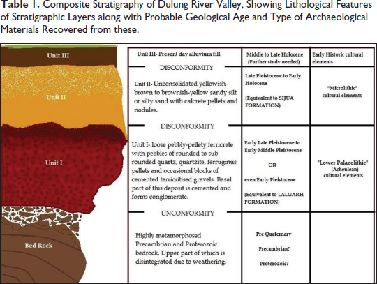
The unit rests over moderately to strongly metamorphosed Precambrian and Proterozoic bedrock with strong unconformity. Unit I has similarities with the early to early-late Pleistocene Lalgarh formation of Eastern India (Chatterjee, 1986; Chatterjee & Chattopadhyay, 1986; Ghosh & Majumdar, 1991). Unit II consists of unconsolidated yellowish-brown to brownish-yellow sandy silt or silty sand. In some sites, moderately to strongly compact overbank fluvial sediments in the form of clayey silt with occasional calcrete pellets and nodules are found in it (Table 1). Unit II lies over Unit I with strong disconformity. Unit II has lithological similarities with the Sijua formation of Eastern India which can be dated to the late Pleistocene to early Holocene (Chatterjee, 1986; Chatterjee & Chattopadhyay, 1986; Ghosh & Majumdar, 1991). Unit III represents the top of the present-day alluvial deposits and it lies disconformably over Unit II. This deposit consists mostly of unconsolidated to loose, yellowish–reddish-yellow clay and sometimes sandy silt of reddish-yellow colour.
Description of the Sites
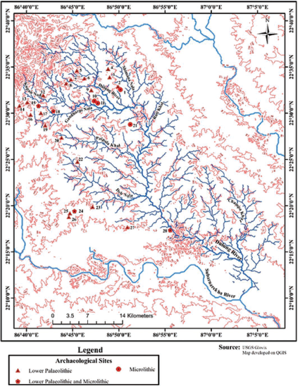
Stone Age sites discovered in this study can be clustered into four broad groups according to their relative locations (Figure 1 and Table 2), these are 1)Ergoda Group of sites (site nos. 1–11), 2)Chakulia Group of Sites (site nos. 12–19), 3)Gidhni Group of sites (site nos. 20–22) and 4)Baharagora Group of sites (site nos. 23–28). From the majority of these sites, Lower Palaeolithic implements have been recovered and some Microlithic implements have been found. No significant differences in the typo-technological attributes of recovered artefacts have been found so far. Among these four groups of sites, Ergoda group and Chakulia group of sites are found in the upper catchment area of Dulung River; on the other hand, the Gidhni and Baharagora group of sites are found in the middle to lower catchment area of the river Dulung (Figure 1). Descriptions of these four groups of sites are given below-
Map Showing the Distribution of the Discovered Sites in Relation to the Contour Lines of the Region and the Drainage System of the Dulung River Valley (Map Prepared on QGIS).
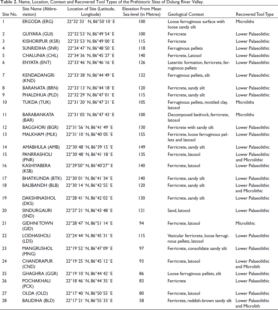
Name, Location, Context and Recovered Tool Types of the Prehistoric Sites of Dulung River Valley.
Ergoda Group of Sites (Group I)
This group includes 11 sites that are located near the large village named Ergoda. Most of these sites are found on the top of lateritic uplands in the vicinity of different paleochannels. A brief description of the individual site is given below:
Ergoda (ERG)[22°32´33 ̋ N ‘,’ 86°50´10 ̋ E]: The site is located almost six km north of Gidhni town. It represents an exposed ferricrete deposit which forms badland at the site. The entire badland is covered by ferruginous pellets. In some areas, a patchy deposit of reddish sandy silt is found over the ferricrete deposit. Few microliths washed away from reddish silty sand have been found scattered over the ferricrete surface. Guiyara (GUI)[22°32´53 ̋ N, 86°49´54 ̋ E]: The site is located almost 7 km north of Gidhni town. It also represents eroded ferricrete upland in the form of a badland. Four Lower Palaeolithic implements comprising handaxe and biface have been recovered from the exposed ferricrete deposit of the site and a broken piece of ring stone has been recovered from the alluvium surface. Kishoripur (KSR)[22°33´53 ̋ N, 86°49´00 ̋ E]: The site is situated almost 9 km north–north-west of Gidhni town. It is a large area with exposed ferricrete deposits. The exposure covers almost 0.50 sq km. A paleochannel is present at the northern boundary of the site. Few Lower Palaeolithic implements comprising handaxe have been recorded from the site. Sunridiha (SNR)[22°34´47 ̋ N, 86°48´50 ̋ E]: The site is situated about 11 km north–north-west of Gidhni Rail station. It is a badland with exposed ferricrete deposits. The exposure is about 0.73 sq km in size. The ferricrete layer lies disconformably over bedrock. Above ferricrete, a layer of latosol is seen. Two paleochannels are present in the eastern and western margins of the site. Handaxe and bifaces have been found on the surface of reddish silty ferruginous pellets. Chalunia (CHL)[22°34´36 ̋ N, 86°45´27 ̋ E]: The site is situated about 11.5 km north-east of Chakulia Rail station. It is a ferricritised land covered by latosol or oxisol. In some parts exposed ferricrete layer is found. The total exposure of the site is 0.38 sq km. The current course of river Dulung flows about 1.5 km north-east of the site. One bifacial cutting tool has been recovered from the site. Enyata (ENT)[22°33´46 ̋ N, 86°46´16 ̋ E]: The site is situated almost 11 km north-east of Chakulia Rail station and is situated at Jharkhand-West Bengal border. Exposure of the site covers about 1.24 sq km area. River Dulung is present at the northern part of the site and a huge deposit of recent silt and clay is present in that part. The southern part of the site represents badland topography, where ferricrete deposit is exposed and is dissected by gully erosion. Lower Palaeolithic artefacts mostly scrapers along with one handaxe and some bifaces have been found exposed in the rain gullies of the site. Kendadangri (KND)[22°33´38 ̋ N, 86°44´49 ̋ E]: It is a stone quarry situated about 9.5 km north-east of Chakulia Railway station. The exposure of the site is about 0.10 sq km and represents a deposit of ferricrete pellets. Paleochannels are observed in the southern and western parts of the site. Few large cores have been found on the alluvium surface. Baranata (BRN)[22°33´13 Phaldua (PLD)[22°32´29 ̋ N, 86°47´01 ̋ E]: This site is situated about 10 km north-west of Gidhni Railway station. It is a badland covered by latosol. The entire site is covered by dense Sal jungle with occasional open lands. In the open lands, rain gully erosion is seen in the latosol deposit and as a result, ferricrete deposits have become exposed. Almost fresh Lower Palaeolithic implements comprising handaxes and bifaces have been found exposed in the artificial dig-out section of the ferricrete deposit. Tukda (TUK)[22°31´20 ̋ N, 86°47´21 ̋ E]: The site is situated about 8 km north-west of Gidhni Rail station. It is a badland, capped by latosol. In some parts of the site, a deposit of mottled clay is found below the latosol deposit. The exposed surface of the site covers almost a 0.25 sq km area and is dissected by a number of rain gullies. Microlithic artefacts have been found exposed near these rain gullies and also near exposed sections. Barbankata (BAR)[22°31´05 ̋ N, 86°47´43 ̋ E]: The site is situated almost 7 km north-west of Gidhni Rail station. It is also a badland where exposure of ferricrete is found, which is occasionally covered by latosol deposits. This ferricrete layer is underlain by decomposed bedrock. The exposure is about 0.17 km in size. The latosol deposit of the site is almost entirely eroded by rainwater erosion, as a result, microliths made out of quartz and chert have been found scattered over the ferricrete pellets.
Chakulia Group of Sites (Group II)
Eight sites have been found in the vicinity of Chakulia town. These sites are also seen near the small tributary canals and paleochannels of the Dulung River (Figure 1). Brief descriptions of these sites are given in the following:
Bagghori (BGR)[22°31´56 ̋ N, 86°41´49 ̋ E]: The site is situated almost 6 km north–north-west of Chakulia Rail station. It is a lateritic elevated upland situated near Bagghori village. One Palaeolithic core has been found from an erosional rain gully over a ferruginous surface. Malkham (MLK)[22°31´10 ̋ N, 86°40´05 ̋ E]: The site is situated almost 7 km north-west of Chakulia Rail station. It is a flat badland (covers almost 1.40 sq km) situated at the bank of a paleochannel. The site is covered by latosol and small scrubs are present over it. Lower Palaeolithic tools have been found exposed within the rain gullies of the site. Tools were eroded out of the ferricrete deposit present below the latosol deposit. Most of the implements are made of quartz while some are made of quartzite and the tools comprise handaxes, scraper and bifaces. Amabhula (AMB)[22°30´48 ̋ N, 86°39´15 ̋ E]: The site is situated almost 8 km north-west of Chakulia Rail station. It is an exposed deposit of ferricrete situated near a paleochannel. Part of the site is covered by sandy silt and recent alluvium. Lower Palaeolithic tools comprising bifacial cutting tools and scrapers have been found scattered over ferricrete deposits. Panrrasholi (PNR)[22°30´48 ̋ N, 86°41´18 ̋ E]: This site is situated almost 5 km north-west of Chakulia Rail station, between Panrrasholi and Kharbanda village. It is a 0.45 sq km open land, part of which is covered by latosol, and the other part is exposed ferricrete deposit. Partially rolled Lower Palaeolithic tools comprising handaxes and bifacial cutting tools, made of quartz and also quartzite have been found scattered over the ferricrete deposit, whereas only one fresh Microlithic artefact has been exposed on the top of the latosol deposit. Kashiyabera (KSB)[22°29’50” N, 86°40’27” E]: The site is situated about 5 km west-north-west of Chakulia Rail station. It is a flat badland mostly covered by loose ferricrete deposits. The size of the exposure is almost 0.30 sq km and part of which is covered by small scrubs. Well-rounded quartz lenses are observed within exposed stratigraphic sections, which indicate stream activity in this area, probably during the Pleistocene. Fresh Lower Palaeolithic tools have been found embedded within ferricrete deposits about 2–3 ft below the surface. Handaxes, cores and scrapers are the main tool type, observed in this site. Bhatkunda (BTK)[22°30´01 ̋ N, 86°41´34 ̋ E]: This site is situated almost 4 km north-west of Chakulia Rail station. It is a badland (occupies almost 0.25 sq km), covered by reddish sandy silt. Ferricrete deposit is exposed near rain gullies. Partially rolled quartz-made handaxe and quartzite-made chopping tool has been found scattered over the surface of dry rain gullies. Balibandh (BLB)[22°30´14 ̋ N, 86°42´55 ̋ E]: It is a large (1.2 sq km) latosol-covered elevated badland situated among three villages namely Balibandh, Salkagarya and Kuchiyasholi. The elevated badland is bordered by small active streams and paleochannels. A number of rain gullies have dissected this elevated land and ferricrete deposit is exposed in these rain gullies. Fresh Lower Palaeolithic tools have been found in the exposed sections as well as in situ in this site. Mostly fresh handaxes have been recovered from the ferricrete deposit. Dakshinashol (DKS)[22°28´41 ̋ N, 86°42´02 ̋ E]: Located almost 2 km west of Chakulia Rail station, it is an exposed deposit of ferricrete overlain by sandy silt. Lower Palaeolithic tools have been found over this exposed deposit of ferricrete.
Gidhni Group of sites (Group III):
Only three sites are included within this group, are- Sindurgauri, Gidhni town and Lodhasholi. Brief descriptions of these sites are given in the following-
Sindurgauri (SND)[22°27´21 ̋ N, 86°43´48 ̋ E]: This site is situated about 2.6 km south of Chakulia Rail station. It is an upland dissected by rain gullies. The site is covered by a sand layer comprising small-sized pebbles. This layer is capped by consolidated latosol deposits in some parts of the site. One quartz-made partially rolled handaxe has been recovered from the surface of the sand layer of the site. Gidhni town (GID)[22°28´47 ̋ N, 86°51´14 ̋ E]: The site is situated almost 1 km south of Gidhni Rail station, near Satsang Ashram. It is a small elevated badland, covered by latosol. Artificially dug-out sections in this badland have shown that the latosol is underlain by a hard ferricrete deposit. One Microlithic artefact has been recovered from the latosol surface. Lodhasholi (LDS)[22°24´44 ̋ N, 86°45´31 ̋ E]: Topographically it is a naturally eroded badland that consists of loose ferruginous pellets. This site is situated 8 km southeast of Chakulia Rail station. Sections of the site show that the ferruginous pellet deposit is underlain by ferricrete with occasional vesicular structure. Highly weathered Lower Palaeolithic implements made of quartz, quartzite and limonite/iron stone slab have been observed on the surface of this site.
Baharagora Group of sites (Group IV):
This group includes six different sites located near Baharagora town (Figure 1). Brief descriptions of these sites are given below:
Mangrushol (MNG)[22°19´52 ̋ N, 86°47´09 ̋ E]: Located about 10 km west of Chichira town, this site represents a ferricrete badland covered by dense Sal forest. Part of the region is also covered by hard consolidated sandy silt. One Palaeolithic core has been recovered from the exposed ferricrete deposit. Chandrapur (CND)[22°19´25 ̋ N, 86°45´12 ̋ E]: Located about 14 km west of Chichira town, this site represents an exposure of latosol-capped ferricrete deposit. The total size of exposure is about 0.10 sq km. A small paleochannel is present at the western side of the site and a number of rain gullies have dissected the site. Fresh in situ Lower Palaeolithic tools comprising handaxes and bifacial cutting tools have been recovered from the ferricrete deposit, whereas very fresh microliths made on quartz have been recovered in situ from the junction of latosol and ferricrete deposit. Ghaghra (GGR)[22°19´10 ̋ N, 86°44´42 ̋ E]: This flat-topped badland is situated in the vicinity of Chandrapur site, near Ghaghra village. It is a ferricrete-capped badland with a size of about 0.10 sq km. Part of the site is covered by scrubs and Sal forest. The exposed part presents a number of small rain gullies. A small channel is present at the eastern side of the site. A large number of very fresh Lower Palaeolithic tools mostly handaxes and also a cleaver and one denticulate have been found scattered over the ferruginous pellet-covered surface of the site and near the exposed beds of rain gullies. Pochalhali (PCK)[22°18´46 ̋ N, 86°44´35 ̋ E]: This latosol-capped flat-topped badland covers an area of 0.15 sq km. In this site ferricrete layer consists of ferric pellets, sand and quartz particles. In the rain gullies, small to medium-sized pebbles are found in a concentric manner. Sometimes pebble lenses are found within ferricrete deposits, which indicate pebble bar deposition. The slope of the site is towards a paleochannel, located in the vicinity of the site. A number of fresh and partially rolled Lower Palaeolithic tools including handaxe, core and bifacial cutting tool have been found exposed over the eroded surface of ferricrete deposit. Olda (OLD)[22°17´40 ̋ N, 86°50´55 ̋ E]: This site is situated about 5 km south-west of Chichira town. It is a badland (covers almost 0.31 sq km)located in the northern part of three villages namely Gohalamura, Olda and Hudli. The entire site is covered by loose ferruginous pellets of ferricrete deposit and part of it is topped by latosol. In some regions, the top of the ferricrete is hardened and makes a conglomerate-like layer. Rolled and highly weathered Lower Palaeolithic implements comprising one handaxe and one notched scraper have been found in the exposed rain gullies of the site. Balidiha (BLD)[22°17´21 ̋ N, 86°55´33 ̋ E]: This site is located between Jugdiha and Poradiha villages, at the southeast of Phenko Ghat. It is an eroded highland (covers almost 0.33 sq km of exposed area), located on the right bank of river Dulung. In the highland, the topmost layer comprises reddish-brown sandy silt/ silty sand. The topmost layer is underlain by ferricrete deposits. Sections near the river Dulung comprise reddish-brown silty sand or sandy silt, this layer is underlain by iron bands and/or reworked ferricrete pellets and at the bottom, a layer of mottled clay is found. In situ microliths made out of quartz, black chert and green chert have been found at the junction between reddish-brown sandy silt and ferricrete deposit, whereas in situ Lower Palaeolithic artefacts have been found embedded within ferricrete deposit. Implements have been found from this site comprising handaxes, choppers, point and scrapers of the Acheulean period and lunates, microblades and flake debitage of the Microlithic period.
Preliminary Observation on the Context of Recovered Artefacts
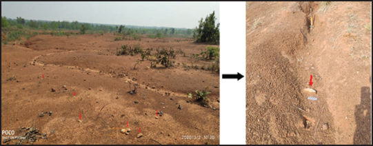
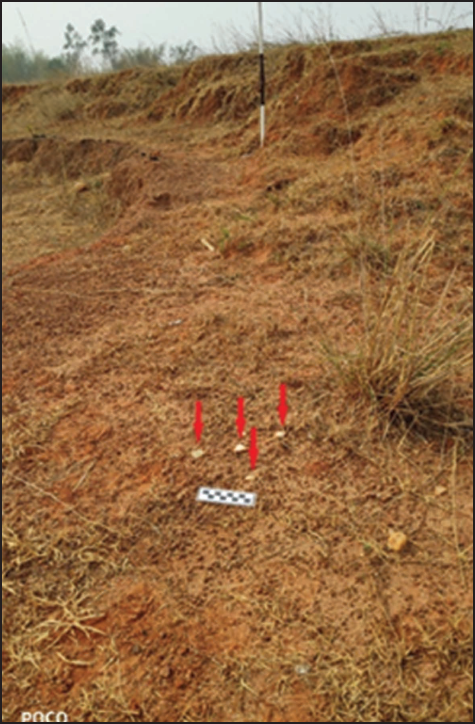
From the stratigraphic context of the recovered artefacts in different sites, it can be said that the Lower Palaeolithic artefacts have been found embedded in the ferricrete deposits of Unit I. Microlithic tools have been recovered in situ at the junction between Unit I and Unit II. In a few cases, Microliths have been found embedded within the lowermost part of Unit II also. Archaeological sites with fresh, in situ Lower Palaeolithic tools have mostly been found in the eroded uplands where the ferricrete deposit of Unit I is exposed. In several sites such as Balidiha, Balibandh, Ghaghra and Chandrapur, etc. (Table 2 and Figure 1), it is observed that the ferricritised uplands and badlands have become dissected by rainwater activities and in situ fresh Lower Palaeolithic tools have been found exposed at the edge of these rain gullies (Figure 2). From the overall studies on the context of Acheulean artefacts, it appears that Lower Palaeolithic artefacts were found in two different contexts and in two different preserving conditions. Some of the artefacts are found in upland regions and they are very fresh in condition. On the other hand, some partially rolled artefacts are found near river channels. The presence of rolled artefacts near present-day river channel deposits indicates that they were probably deposited by the transportation activity of the river; whereas fresh artefacts in the ferricrete uplands indicate that probably they were probably less affected by erosion and deposition of river channels. Microlithic tools have been found at the junction between Unit I and Unit II deposits which are exposed at the bank of rain gullies. Site Balidiha is a typical example of this occurrence, where in situ Microlithic tools have been found exposed at the junction between ferricrete and sandy silt deposits. In some other sites such as Ergoda, Barbankata, Tukda, etc. (Table 2, Figure 1), Microlithic artefacts have been found scattered over exposed Unit I deposits where Unit II deposit has been washed away by rainwater (Figure 3).
Lower Palaeolithic Artefacts (Marked by Red Arrows) Scattered in the Field (Site Ghaghra on the Left and Site Balibandh on the Right)and in the Rain Gully (Visible Scale is in cm).
Preliminary Observations on Recovered Lithic Artefacts
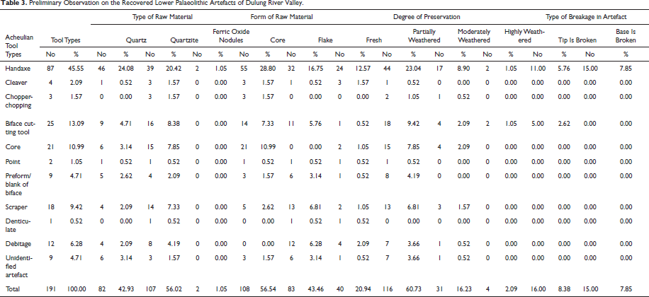
A total of 234 artefacts have been recovered in the present exploration. Among these recovered artefacts 191 belong to the Lower Palaeolithic cultural period, more particularly to the Acheulean industry and 42 belong to the Microlithic cultural period and only one broken part of ring stone probably belonged to the Neolithic cultural period (Tables 3 and 4). Out of the 191 artefacts of the Acheulean industry a quite significant number of tools (i.e., 31 numbers) are broken, more particularly to say that a significant number of handaxes are broken (26 out of 87 handaxes). All the Lower Palaeolithic artefacts have a deep reddish patina. Most of the Lower Palaeolithic implements are fresh (40 nos.) to partially weathered (116 nos.). Moderately weathered implements are 31 in number. The numbers of intensely weathered implements are very few (4 nos.). Microlithic implements are mostly fresh (22 nos.) to partially weathered (20 nos.) and they do not have patina over them.
Preliminary Observation on the Recovered Lower Palaeolithic Artefacts of Dulung River Valley.
Preliminary Observation on the Recovered Microlithic Artefacts of Dulung River Valley.
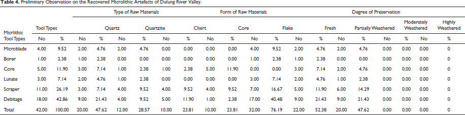
In the case of Acheulean tools, the principal raw material comprises quartzite and then quartz (Table 3). Sites such as Baranata, Kendadangri, Kishoripur and Enyata have exposed quartzite outcrops which have been probably used as a source of raw material for Lower Palaeolithic tool makers. Quartz is found as blocks and veins of weathered Proterozoic rocks of the region. From the general observation of the tools, it has been found that a number of implements are made of quartzite and quartz cobbles of different sizes. These cobbles have been probably collected from the beds of the active paleochannels of this region. Only two implements, made on ferric oxide nodules have been found in the present exploration. Sources of ferric oxide nodules are the exposed ferricrete deposits of Unit I. Microliths recovered in this exploration are mostly made on quartz nodules, found plenty in ferricrete deposits. Besides quartz fine-grained quartzite and chert nodules have also been used as raw materials for the Microlithic tools (Table 4). The only broken ring stone recovered in this exploration is made on a schistose rock. The local source of this raw material is not known; probably it was manuported from an unknown locality of long distance.
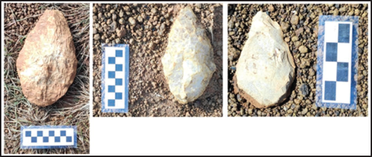
Acheulean artefacts, recovered in this exploration are broadly classified into 11 different tool types, of these; majorities are handaxes and bifacial cutting tools (Table 3). From the general observation, it appears that handaxes are very finely made with almost straight working edges and very thin longitudinal sections (Figure 4). Most of the handaxes are made on core and a few are made on flake. Cleavers and chopper-chopping tools are fewer in numbers but the number of scrapers of different types and cores is quite significant. Cores recovered in this exploration are bifacial and are smaller in size. The distribution of flake patterns in those cores indicates that probably they have been exploited using a multidirectional reduction strategy, however, this can be confirmed after a detailed analysis of the recovered cores. Scrapers are mostly made on flake and are smaller in size. Besides scrapers, denticulates and points have also been recovered from these sites. Microliths recovered in the present exploration are non-geometric; they are mostly irregular-shaped scrapers and debitages of Microlithic components (Table 4). Finished tools such as microblade, lunate, etc., are fewer in number. Detailed analysis of both Acheulean and Microlithic assemblages is still going on and will get detailed insights about these artefacts after the completion of these analyses.
Typical Acheulean Handaxes Exposed in Different Sites (Scale in cm for the Left two and in inch for the Right one).
Summary and Discussions
Present discovery reveals that the Dulung River valley was one of the important paleo-ecozones of Eastern India, where prehistoric people lived from the Lower Palaeolithic to the Microlithic era. However, the presence of archaeological evidence of later times in the surrounding regions of the Dulung River valley indicates a continuous evolution of man in this region from the earliest times up to modern days. The discovery of Lower Palaeolithic tools in the Quaternary ferricrete deposits of the Dulung River valley indicates that early human activity in this region can be dated back to early-middle Pleistocene to early-late Pleistocene, as suggested by the geologists working on ferricrete laterites in this region (Chakraborti, 2011; Ghosh & Guchhait, 2020) as well as archaeologists working on Lower Palaeolithic culture of India also (Mishra et al., 1995; Paddayya et al., 2002; Pappu et al., 2011). The ferricrete deposit of the Dulung River valley is not dated yet; however, ferricrete deposits of the Bengal basin have been dated by Chakraborti (2011). His study indicates the earliest date of ferricrete formation in Eastern India goes back to 154 ka BP (Chakraborti, 2011:80) which falls securely within the middle Pleistocene. Microliths are found in the stratigraphic context equivalent to the Sijua formation of this region, which can be dated back to the late Pleistocene to early Holocene (Achyuthan et al., 2012; Basak et al., 2014; Ghosh & Guchchait, 2014).
Exploration in the Dulung River valley shows that Lower Palaeolithic sites or more precisely Acheulean sites are mostly found in the ferricritised upland and dissected erosional plateaus of upper catchment regions of Dulung River, near the margins of small tributary channels and paleochannels. The river is the principal agency for shaping the morphology of this valley. As it is mentioned previously rainwater flow over the ground acts as one of the major erosional agents of the region. Regarding the stratigraphic context of recovered artefacts, it can be said that the Lower Palaeolithic artefacts have been found embedded within the ferricrete deposits, which has a similarity with the early to late Pleistocene Lalgarh formation (Ghosh & Majumdar, 1981, 1991).
From the general observation of tools, it appears that handaxes are very finely made with an almost straight working edge and a very thin profile. Making such fine handaxes on raw materials such as quartz and quartzite indicates the highly skilled craftsmanship of the makers of these tools. The source of quartzite is the exposed and weathered Precambrian and Proterozoic rocks of the Tata-Dalma hill range in general; however, sites such as Sunridiha, Kendadangri, Kishoripur and Enyata have exposed quartzite outcrops. Quartz is found as blocks and veins of weathered Proterozoic rocks of the region. From the general observation of the tools, it is found that a number of implements are made of quartzite and quartz cobbles of different sizes. These cobbles were probably collected from river beds of the region which were active in the past. Only two implements made on ferric oxide nodules have been found in the present exploration; these ferric oxide nodules are found plenty in ferricrete deposits, exposed in almost all sites.
Quaternary sediments of the Subarnarekha River basin and its adjoining regions have been studied by several geologists, and their importance in the understanding of the succession of prehistoric culture of Eastern India has also been revealed by them (Chakraborti, 2011; Chatterjee, 1984; Chatterjee & Chattopadhyay, 1986; Ghosh & Majumdar, 1991). River Dulung and its small tributaries are located between the Subarnarekha River valley and the Kangsabati River valley. The importance of the Subarnarekha River valley and Kangsabati River valley in the understanding of the succession of Stone Age cultures of Eastern India have been have been proven by several previous studies (Basak, 1997; Basak et al., 1998; Chakrabarti, 1993; Ghosh, 1970). Although in the present study, we have not been able to compare the typo-technological attributes of the artefacts collected from the Dulung River valley with that of the Subarnarekha and Kangsabati River valleys. Still, the concentration of archaeological sites at the upper reaches of the Dulung River valley and also the succession of cultures in this region indicates that perhaps Dulung River valley was one of the several important paleo-ecozones of Eastern India where prehistoric people inhabited and lived for a long time. In the present context, it is not possible to make any comment on the number of hominin groups living in this region and their relations with each other, only further studies in the future can answer these questions.
The concentration of prehistoric sites in the Dulung River valley reveals that our ancestors probably roamed over the dissected ferricretised river valleys of this region during the end of the Pleistocene and early Holocene for their resources of living. The presence of several very fresh in situ artefacts over the lateritic mounds of this pediplain region indicates the presence of possible habitation or campsite in this region; however, only more intensive studies in the future can give support to this claim. Finally, it can be said that the importance of this study lies in the discovery of 28 new prehistoric sites in Eastern India and in conducting the first systematic archaeological exploration in the Dulung River valley of Eastern India.
Footnotes
Acknowledgements
Salutation goes to University Grant Commission, New Delhi for the Junior Research Fellowship, granted to the second author (SKB) for his PhD research. The authors are grateful to Prof S. N. Rajaguru, former professor of Deccan College Post Graduate and Research Institute, Pune for his kind comments on the geological observations in the region. Acknowledgement goes to Satsang Ashram, Gidhni and Marwari Dharamsala, Chakulia for kindly providing accommodation to the authors during fieldwork. The authors are thankful to the local people residing in Dulung River valley for their support during fieldwork. SKB is also thankful to Jabir Ahmed and Nabakumar Bal for their help during fieldwork.
Declaration of Conflicting Interests
The authors declared no potential conflicts of interest with respect to the research, authorship and/or publication of this article.
Funding
The authors received no financial support for the research, authorship and/or publication of this article.