
Abstract
Geospatial-qualitative methods, which combine both observation and interpretative accounts during data collection through extended exposure and movement in place, have been increasingly used to explore “person–place” interactions and assess communities of place. Despite their increased use, there is a lack of reflexive discussion on how they differ in capturing person–place interactions and ways to combine them. Drawing on our experiences using three related methods—Photovoice, Walking through Spaces, and interactive Participatory Learning and Action exercise-led community focus groups—we compared the methodological advantages that each method brings to the construction of “place” and in exploring person–place interactions among the community of older adults living in a neighborhood of Singapore for a neighborhood assessment. We then illustrated how using a Focus–Expand–Compare approach for methodological triangulation can add value in generating greater depth and breadth of perspectives on a topic of interest explored for intervention development.
Keywords
Introduction
Exploring the everyday meanings, culture, and practices in place is a central feature of ethnography (Hammersley and Atkinson, 2007). While space denotes a location with no social connections, “place” is more than a location, but a “space” that is filled with meanings based on individuals’ experiences (Tuan, 1977). As such, explicitly acknowledging the role of place in a methodological approach is important to understand its effect on health and behavior and inform the design of effective community interventions (Bronfenbrenner, 1977; Golden and Earp, 2012). To explore person–place interactions, ethnographers, phenomenologically minded sociologists, and human geographers have increasingly converged toward geospatial-qualitative methods (Andrews et al., 2007) beyond classic ethnographic methods such as observation and interviewing. These methods (such as Photovoice and Walking through Spaces) often involve the participant in observing and narrating spatial practices and interactions in neighborhood place, directly grounding the research in participants’ experiences of place (Hand et al., 2017). Despite their increased use, few studies have reflected on how they differ in capturing person–place interactions. In this article, we draw on our experience using some of these methods in a community assessment, comparing and discussing ways of triangulating multiple participatory and geospatial-qualitative methods for capturing person–place interactions among older people.
Role of geospatial-qualitative methods
Place is central to well-being (Mahmood et al., 2012; Plane and Klodawsky, 2013), especially at older ages, where older people can become more confined to their local surroundings (Rowles, 1978). Both the Ecological Theory of Aging (Lawton and Nahemow, 1973) and transactional perspectives (Andrews et al., 2007) emphasized how place is a dynamic rather than static entity where person–place transactions are complex and imbued with meaning. Wahl et al. (2012) highlighted the role of identity, belonging, and place attachment within the person–place relationship.
When selecting methods to explore person–place interactions, it is therefore important to consider how these methods create the opportunity for observation and eliciting interpretative accounts during data collection. Doing so is key to overcoming the constraints from using observation methods or interpretative methods alone (Hand et al., 2017; Huot and Laliberte Rudman, 2015; Suzuki et al., 2007). For example, participant or non-participant observation methods used in classic ethnography (Schwartz and Schwartz, 1955) can assess neighborhood places and capture micro-level interactions of participants with place. However, they are less suitable to elicit aspects of meaning, identity, and belonging from the participant’s perspective. Moreover, without involving participants in observing their own neighborhood, the researcher may run the risk of curating observations to explore in follow-up interviews.
Interpretive interview-based methods, such as narrative interviews, can be used to explore aspects of meaning, belonging, and identity (Reissman, 2007). However, without embedding observation, they have their limitations in capturing the “nuance of daily movements, practices, and relationships” (McLee, 2013: 283) in place and other subconscious elements of places and daily life that are challenging to articulate (Nunkoosing, 2005). As individuals often seek to discuss salient aspects featuring in their immediate stream of consciousness (Quinn, 2002), extended exposure and movement in one’s neighborhood is required to realize pre-reflective spatial practices or knowledge (Kusenbach, 2003).
Addressing these limitations, geospatial-qualitative methods (Gardner, 2014; Hand et al., 2017; Van Cauwenberg et al., 2012) combine both observation and interpretative accounts during data collection. By using extended exposure and movement through one’s neighborhood, they can capture micro-level details that are either overlooked or less explicit in interviewing methods (Hand et al., 2017). Examples of these methods include “walking through spaces” interviews, otherwise termed as “go-along” interviews (Carpiano, 2009), where qualitative interviews are conducted by researchers accompanying individual informants on outings in their familiar environment, such as a neighborhood or larger local area. Through asking questions and observing, the researcher is able to examine the informant’s interpretations, experiences, and practices within their natural environment. Given its ability to generate interpretative accounts during movement in places, the method has therefore been highlighted as an unique tool to examine how physical, social, and mental dimensions of place interact within and across time for individuals (Cummins et al., 2007).
This opportunity to embed both observation and interpretative accounts also features in a visual photo-documentation and story-telling method called Photovoice. First developed by Wang and Burris (1997) to promote dialogue among rural women in Yunnan on the policies and programs affecting them, the method was built on the belief that images and words together more effectively express communities and individuals’ needs, problems, and desires than words alone. Participants are often asked to observe and take photos highlighting community concerns, assets, social issues, personal experiences, or public health barriers, and to use these photos to express their views and give voice to their communities. These photographs are typically interpreted through follow-up interviews or focus groups discussions to generate narratives around the photos and solutions to shared issues (Wang et al., 1998). Photovoice has been used in different populations such as refugees (Sethi, 2014), cancer patients (López et al., 2005), homeless adults (Wang et al., 2000), older people (Chaudhury et al., 2012; Lockett et al., 2005; Mahmood et al., 2012), and youth as a tool for story-telling and to mobilize grassroots action.
To map spatial movement precisely in real time, Global Positioning System (GPS) tracking has been used in neighborhood assessments to track activities, movement, and services used in the neighborhood (Kwan and Ding, 2008; Loebach and Gilliland, 2016). However, in a scoping review of geospatial-qualitative methods used among older people, Hand et al. (2017) found that individual’s geospatial data were often used to supplement follow-up interviews, for example, as a prompt or to verify participants’ activity diaries, which were more useful in explaining why and how activities were undertaken. Depending on the research question, obtaining detailed geospatial data by GPS tracking may not be necessary, particularly if the focus is more on understanding how older people perceive their community of place and eliciting more participatory assessment for action.
Toward this end, quick and “dirty” mapping methods have been used in Participatory Learning and Action (PLA), Appel et al., 2012 previously referred to as rural participatory appraisal methods (Loewenson et al., 2014; Narayanasamy, 2009)—for example, using the “a day in the life” timeline activity to describe the activities and spatial practices of a selected community group, thematic mapping of community resources and neighborhood services with reference to a physical map (Maalim, 2006; Terry and Khatri, 2009), which is sometimes also combined with walking interviews within the neighborhood. These group activities are typically conducted organically in neighborhood places (e.g. allowing passersby to join and leave), with the aim of eliciting rapid overviews of the community and group dynamics, before further inquiry.
Unpacking methodological triangulation
Despite the increased use of these place-sensitive methods, there is a lack of reflexive discussion on how they differ in exploring person–place interactions and communities of place and consequently how they are best combined for methodological triangulation. Denzin (1978: 291) introduced the idea of triangulation in qualitative research as “the combination of methodologies in the study of the same phenomenon.” Originally conceiving triangulation as a strategy of validation, he distinguished different types of triangulation. A central concept is that of methodological triangulation, which is characterized as “a complex process of playing each method off against the other, so as to maximize the validity of field efforts” (Denzin, 1978: 304). He further outlined three steps for methodological triangulation: First, the nature of the research problem and its relevance to a particular method should be assessed . . . Second, it must also be remembered that each method has inherent strengths and weakness . . . Third, methods must be selected with an eye to their theoretical relevance. (p. 303)
Therefore, to inform ways of methodological triangulation, our first objective was to compare the viewpoint that multiple geospatial and qualitative methods provided in exploring person–place interactions. We draw on our previously published study using photovoice, walking through spaces and community focus groups with embedded Participatory Learning for Action (PLA) activities for a community assessment with older adults in the Whampoa neighborhood of Singapore (Aw et al., 2017). These three methods were chosen as we wanted to elicit more participation in observing and narrating about their neighborhood, as compared to GPS tracking which can be considered to be more “passive” in nature, and elicited concerns of surveillance, and comfort level with technology.
The explicit ways in which the chosen methods can complement one another and add value will only be useful if it is also made explicit how to use each of these to their best advantage. Thus, our second objective was to illustrate a framework for methodological triangulation, which we outline in the Focus–Expand–Compare approach to combine the three proposed methods. We contend that gaining a greater breadth and depth of an issue can be generated by first explicitly focusing on central topics in data collection and defining core themes, allowing for mapping and mixing methods on consistent definitions; second, expanding on initial themes and deepening insights through more open-ended inquiry; and, finally, comparing perspectives to confirm and build on what is already known (Denzin, 1978; Silverman, 2005).
Comparing methodological viewpoints
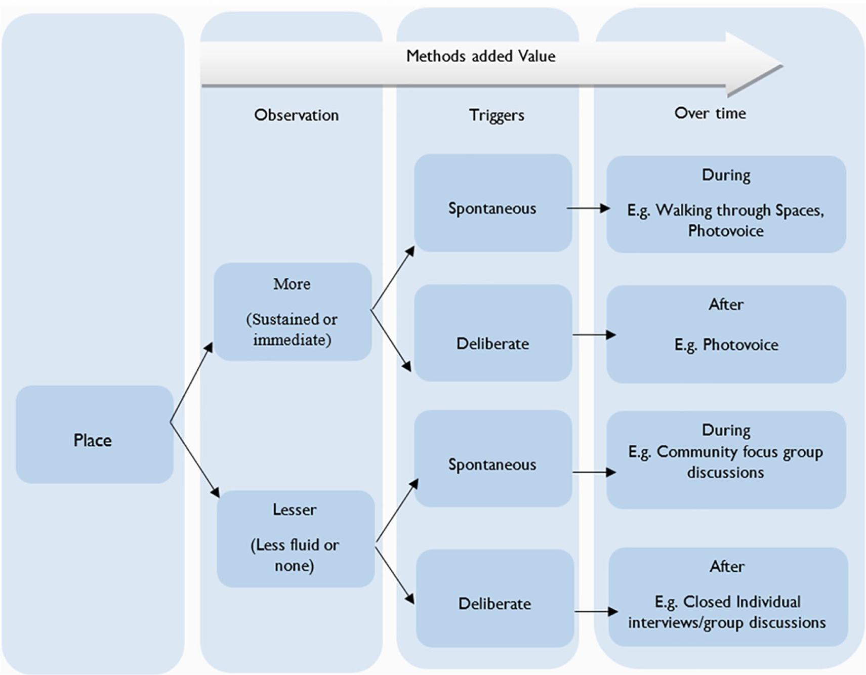
Herein, we conduct a reflexive analysis to provide an in-depth comparison of each of our chosen methods, generating a taxonomy defining their interaction with place based on two features: the degree of observability among them, and the different way in which they trigger discussion and help interpretive accounts unfold. “Observability” refers to the degree that the method allows the researcher to observe the neighborhood. This can occur as the researcher moves through the neighborhood, lingers on it through photos or are hosted within it. Traditional methods such as in-depth interviews and focus group discussion, when used in closed settings, have limited observability. Instead, they rely on recollection, tapping into experiences and perceptions in more disassociated ways. “Triggers” refer to features of the method that elicit discussion about the research topics over time, or how the method interacts with place, either spontaneously (during data collection) or more deliberately (after data collection) to get participants talking about their neighborhood. We therefore draw on our experiences using photovoice, walking through spaces, and PLA activities conducted in community focus group discussions (CFGDs) to reflect on these two methodological features. Combining these categories on two dimensions, we locate and discuss our use of photovoice, walking through spaces, and CFGDs within this implicit taxonomy (Figure 1).
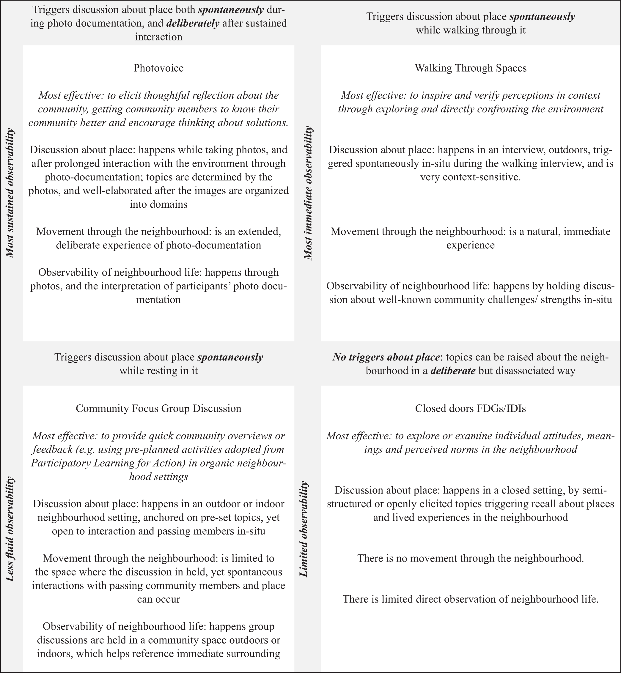
Taxonomy of interaction with place.
Photovoice allowed the most sustained observation of the neighborhood through the eyes of older people who were given the role of photo-documenting their communities. Photos allowed the researchers to use observed events, space, and people that were experienced during photo-documentation and prompt discussion around them. Details captured in the photo-journal (e.g. date, location, and significance of the event) were also used to dig into the context of the event and why it was important to capture. Such sustained observation enabled participants to notice services or structures they had not been aware of before or talk to people in their neighborhood they would not normally approach. As noted, Because of Photovoice, I really get to see many things. For example, those cyclists. Normally I would not notice them. I would just go to and fro from work, stay at home and never walked around the estate. (PV2)
Discussion about place was first triggered spontaneously when participants interacted with neighborhood members during photo-documentation. For instance, participants told us their conversations with impoverished older people collecting cardboard on the streets, which was prompted when they requested to take their photo. Discussion about place was then triggered deliberately, when they returned in a focus group discussion after digesting their observations for 1 month. This encouraged thoughtful reflection on what affected lives of older people the most and the diversity of experiences in the neighborhood.
Walking through spaces prompted the most immediate observation of the neighborhood, as the researcher and interviewee walk through the neighborhood landscape, while the interview was conducted. As one community volunteer interviewed elaborated, Actually, when you asked me to show you around, I knew where to bring you to. This is something new (points to exercise corner). They have all these things (exercise equipment’s). Older people can hold and walk and move around. (WTS4)
During the walking through spaces interview, discussion about place was triggered spontaneously as both the researcher and participant could observe and comment on what they observed while they walked through the neighborhood. In this way, discussion was anchored to context as the landscape inspires, confirms, or rejects perspectives from the researcher or participant, allowing the most instant connection with place. In line with other researchers using walking through spaces, we found this encouraged community volunteers to share their personal ties to the neighborhood and focus on neighborhood issues close to their heart, often elaborating on the socio-ecological context that explained these issues (Carpiano, 2009).
Compared to walking through spaces and photovoice, CFGDs offered observation that was less fluid in nature, as they were anchored in a neighborhood place of significance. Nevertheless, discussions about place could still be triggered spontaneously, as participants interacted with their immediate environment by pointing out to observable environmental features (e.g. nearby services, curbs, or crossings) or issues. One CFGD conducted in a covered gathering place located at the void deck of housing apartments, prompted this response: To inform us [on upcoming programs], you just need to paste the posters there [points to notice board near the entrance to the apartment block] and the people will read if the activities are suitable. Not so troublesome for you. (CFGD2)
PLA exercises such as timeline and neighborhood mapping using spatial guides provided a framework to elicit context-sensitive discussions. For instance, we used a timeline mapping exercise describing a “day in a life of a vulnerable elder” to discuss where these older people lived and frequented in the neighborhood. Doing so allowed us to collect structured data for programming, without yielding lengthy ethnographic notes. Although discussion was structured using the exercises, allowing the flow or dynamics of discussion to be shaped by passing people and happenings in the surrounding made CFGDs more porous to the dynamics of neighborhood places.
Triangulation of methodological viewpoints
Examining how each method interacted with place enabled us to choose between them to focus, expand, and compare perspectives on aging experiences in the neighborhood. We first used CFGD activity to focus deductively on experiences of aging successfully versus vulnerably to provide “snapshots,” or quick contextualized overviews of lives of older people, helping us save time. Next, we used photovoice to expand on these perspectives (inductively on everyday meanings, culture, and practices in place) since it allowed more sustained and deliberate observation. Finally, as walking through spaces offered immediate observability and spontaneous triggers for discussion, we used it to compare perspectives of older people with community volunteers (deductively while open to new themes that amplify or generate discrepant comparisons).
Figure 2 illustrates how the Focus–Expand–Compare approach of combining the three methods allowed us to generate greater depth and breadth of perspectives from older people and community volunteers, on successful versus vulnerable aging. Details about data collection are reported elsewhere (Aw et al., 2017). For example, using an association task, CFGD focused on eliciting older people’s associations with the term “successful ageing” in the neighborhood. We found most drawings related to the themes of active engagement and security. Using another PLA activity to elaborate on “the day in a life” of vulnerable elder, CFGD data pointed to vulnerable older people being likely to reside in precincts with one-room rental flats subsidized by the government. Many were described as living on the margins with little or no income.
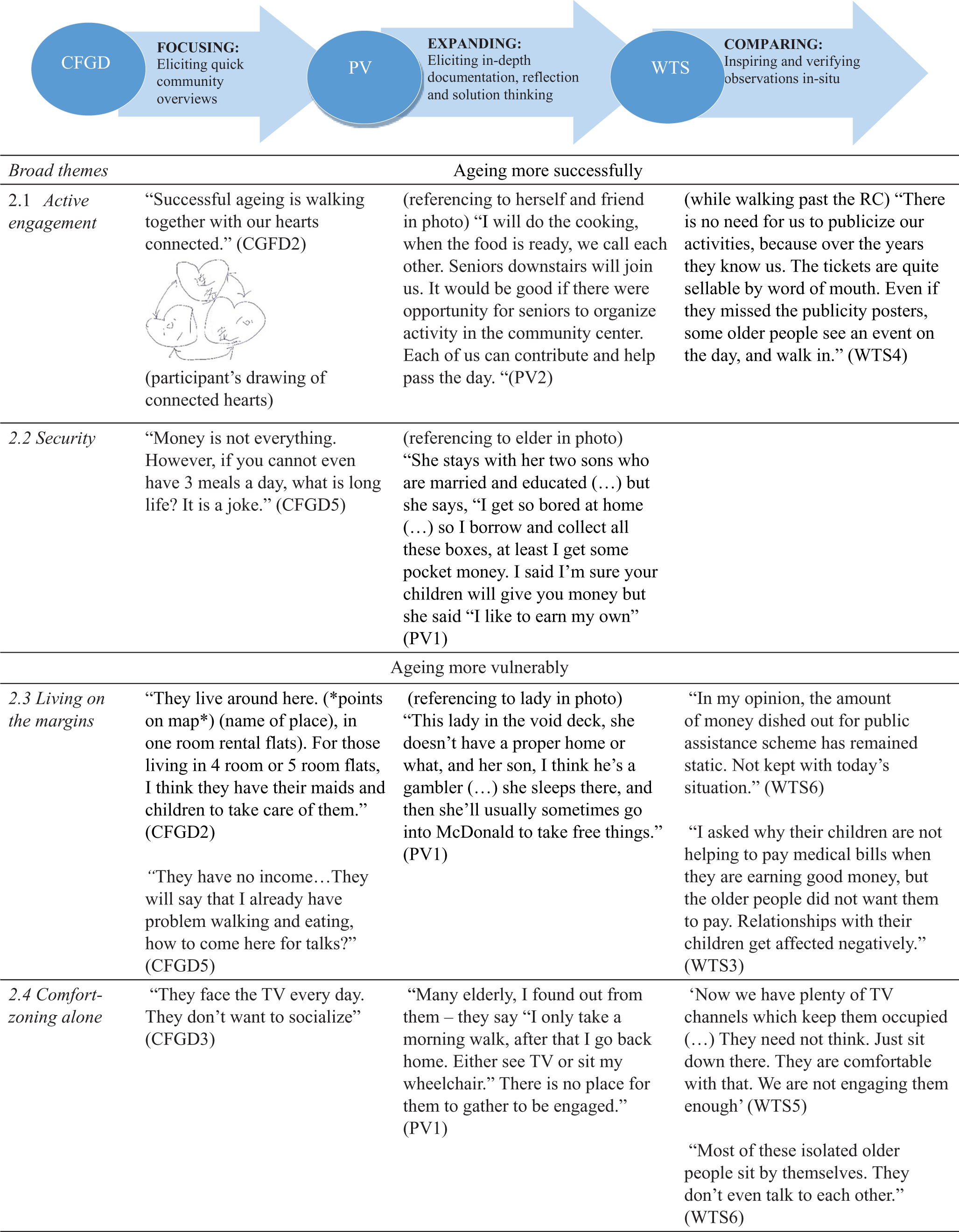
Illustrating views on aging successfully, or vulnerably in the neighborhood.
However, starting with CFGDs elicited only cursory descriptions of vulnerability. It was through photovoice that underground stories of homeless and marginalized older people were unearthed, expanding themes about older people living on the margins. Through in-depth documentation over 1 month, participants approached and interacted with the street-bound cardboard collectors and those living with no fixed abode in void decks, to understand their lives. Participants also expanded on themes of active aging, using photos of themselves or others being active in the neighborhood, and holding them up as exemplars of successful aging.
In addition, we saw a communal process of thoughtful reflection occurring, where participants themselves started to suggest how older people could come together to organize activities and encourage those who were not currently taking part. Reflecting on the circumstances of these marginalized older people motivated participants to tell their stories and to find ways to make their lives better. Recognizing the potential of photovoice, the program implementers have adopted it to train older people to do their own community assessments, thereafter using proposed solutions to launch elder-led interest groups.
We compared themes of comfort-zoning alone from CFGD and photovoice with our own observations of elderly men in neighborhood spaces during walking through spaces walkabouts—who sat by themselves, looking visibly disengaged. Community volunteers highlighted how these older people mostly avoided social interaction with one another, even as they used the same spaces. As we walked through the more vulnerable precincts, community volunteers explained the circumstances leading to older people living on the margins, attributing this to the “open secret” of financial subsidies that were not working, and how community activities on offer were not sufficiently engaging isolated older people. The immediate and direct observability of walking through spaces was therefore useful to compare and verify themes elicited by photovoice and CFGDs, particularly for more concrete and observable topics.
Therefore, unlike previous frameworks (Morse, 2010) which argue that analysis of multiple qualitative methods should inductively drive and require delineation of a core and supplementary method strand, our illustration demonstrated that analysis across methods can be meaningfully integrated without one method needing to dominate another. We used the pairing of different participant groups and methods to expand and compare themes, not to override or give one method/group more importance over another. This step-by-step approach facilitated the scaffolding of analysis to drive constant comparison, verification, and sequential triangulation. This step-wise triangulation enables an explicit testing of the data, similar to how code manipulation techniques are used in Grounded Theory approaches (Strauss and Corbin, 1990) to drive out ambiguities and contradictions, systematically building on emergent themes as data are collected.
While not all themes elicited by CFGD, photovoice, and walking through spaces will fall neatly in categories of Focus–Expand–Compare, overall this framework provided structure and meaning, helping to increase the breadth and depth of perspectives (Flick, 2017). To overcome possible analytic incomparability across methods, in photovoice, we focused on the themes that emerged from the top five photos that each participant chose and narrated, rather than content analysis of the photos. Methodologically, we have also demonstrated how our three methods added value, according to how they spontaneously or deliberately embed triggers to discussion about place over time that is either during or after observation (Figure 3).
Summarizing construction of “place” across methods.
Challenges and limitations
Nevertheless, we encountered several technical issues when using each method which required different mitigating strategies. For example, in CFGD and walking through spaces, we occasionally had to deal with collecting data in noisy places, especially if we were walking through a busier place in the neighborhood, or conducting the CFGD in open places with existing events held nearby. Consequently, we were mindful to conduct the CFGD in open but more private community spaces (e.g. a few blocks away from concurrent community events) and repeat what the interviewee shared earlier in nosier places so that they could be captured in the audio-recordings. While we did not encounter any weather or safety issues, these should be considered when conducting walking through spaces in seasonal countries and neighborhoods with high crime rates.
In analyzing interview transcripts collected during walking through spaces, we found it was important to link commentary on a place to its location in order to situate the interview (e.g. streets, stores). Given the conversational nature of walking through spaces, interviewees sometimes used vague language in describing the environment (e.g. “see that street over there, those houses”). When such statements are typically adequate for pointing out an object in the immediate environment, it may be difficult to recall it later when analyzing the audio-recordings (which house, and why?). To overcome this problem, we explicitly mentioned the route taken while walking (e.g. “we have just turned right to the community center in XX”) and integrated field-notes that detailed the researchers’ observations of their locations as they walked through neighborhood places, and whether these verified with observations narrated by the interviewee. Another solution suggested by Carpiano (2009) is to make notations on a physical map of the neighborhood during the interview.
For photovoice, we were concerned whether the photo-documentation would invade the privacy of residents in the neighborhood and pose as a nuisance. We took care to train participants in the ethics of photo taking when we handed out the Polaroid cameras. This included reminders not to take photos of individuals in their homes or private spaces. When photographing individuals in public spaces, we advised that that their faces were not closed up or identifiable. In the case where the photo focused on an individual, we encouraged participants to approach them to request for their photo, and explain that they were participating in a study to explore lives of older people in Whampoa.
Conclusion: triangulation as a form of design thinking
While we locate our use of photovoice, walking through spaces, and CFGDs in our taxonomy of interaction with places, we recognize that these methods can be adapted in different ways. Dennis and colleagues used photovoice more spontaneously by embedding it in a walkabout with the researcher, similar to walking through spaces (Dennis et al., 2009). This was unlike our use of photovoice, where participants photo-documented their neighborhood for 1 month, hence eliciting more sustained observability and deliberate interaction with place. Although we used CFGD, photovoice, and walking through spaces sequentially to focus, expand, and compare perspectives, this sequence could be switched around depending on the context of the study. When little is known about the study population, or when collecting data on a taboo and private topic, starting off with a more inductive approach to expand, focus, and then compare perspectives may be more effective. The technical challenges associated with different methods should also be considered within the context of the study population to assess how to adapt its usage.
With the increased use of participatory and geospatial-qualitative methods, familiarization with how photovoice, walking through spaces, and CFGD interact with place is likely to be useful for the researcher to fully harness the benefits of each method. One limitation of this methodological paper was therefore that we were unable to reflect on the way in which geographic information systems capture person–place interactions (Kwan and Ding, 2008; Loebach and Gilliland, 2016) as we perceived this method to be less community and more geography focused and did not adopt it as our neighborhood assessment. Based on a scoping review of geospatial-qualitative methods used among older people (Hand et al., 2017), all six studies using GPS tracking supplemented it with writing activity diaries and follow-up interviews (Kwan and Ding, 2008; Loebach and Gilliland, 2016). Maps of participants’ movement in the neighborhood were used as an interview prompt or to verify participants’ activity diaries, to understand factors influencing activities and services used in the neighborhood.
We recommend that researchers consider triggers, either spontaneous or deliberate, and degrees of observability, to decide what kind of interaction with place they want to elicit. We also recommend giving due consideration to how participatory in nature the community assessment intends to be. Community assessments that seek to support participants toward implementing bottom-up solutions themselves should consider methods that allow for more sustained observability and deliberate interaction such as photovoice. Depending on the research focus (e.g. individual or community as unit of analysis), detailed geospatial data using GPS tracking may not be necessary, particularly for community assessments that seek to be more participatory, given the arguably more “passive” nature of GPS surveillance. How each method can complement one another should be made explicit and mapped onto an analysis that mixes them across consistent topics. Such design thinking contributes toward efficient, value-added structuring of data collection and analysis.
Footnotes
Acknowledgements
We gratefully acknowledge the support of our community partners, Tsao foundation, and our research participants for their active engagement in the research process.
Author Contributions
SA and ZJ-lH conceived of this article, with inputs from YJO, GCHK, and MLW while SCH and MABG helped with acquisition of the data. ZJ-lH, YJO, and SA led data collection. SA wrote this article, which was edited by ZJ-lH. All co-authors commented meaningfully and approved the final version for submission.
Declaration of Conflicting Interests
The author(s) declared no potential conflicts of interest with respect to the research, authorship, and/or publication of this article.
Funding
The author(s) disclosed receipt of the following financial support for the research, and authorship of this article: This work was supported by the Tote Board Singapore, Ministry of Health, working in partnership with Agency for Integrated Care (AIC) in Singapore. The funders are not involved in in the study design, collection, analysis and interpretation of data, writing of the article, and decision to submit it for publication.