
Abstract
The body of information on the Internet is becoming increasingly geographical. This is both due to the expansion of established categories of geographic information (e.g., digital maps and geospatial databases) and to the simultaneous enrichment of other types of information through geographic identifiers (e.g., geotags, check-ins, and global positioning system coordinates). As this repository of geographic information expands, it is also a key site for multiple processes of commodification transforming informational resources into market goods. Understanding the dynamics driving the integration of geographic information into the digital economy requires a comprehensive political economic analysis. A key component of this analysis is to explain the logics of creation and allocation of economic value from geographic information on the Internet. Addressing this need, in the present article I deploy the property regimes schema developed by Schlager and Ostrom and expand it to elucidate the differentiated commodification processes of geographic information on the Internet. Property regimes are arrangements that define rules, distribute rights, and delineate roles with respect to particular goods. These arrangements are enabled by elements such as legal frameworks, jurisdictions, type of information, and technologies of access. In this article, I explore how the legal frameworks regulating traditional categories of geographic information (such as maps) have been destabilized in the process of technological innovation, leading to the creation of new informational goods along with their respective property regimes, and rearticulating legal, economic, and sociotechnical relations. To illustrate this, I analyze the case of Google Street View images through their property regimes in various jurisdictions.
Keywords
Introduction
The overarching goal of this article is to analyze and explain the commodification of geographic information on the Internet by examining the property regimes that emerge in this process. Property regimes are ways of organizing diverse bundles of rights with respect to a specific resource. These rights are the product of rules, which define how they can be allocated to particular actors, which in turn creates roles with specific functions within the property regime.
A well-defined conceptual schema of property regimes can help sharpen the analysis and management of resources and their economic exploitation. In this article, I mobilize the schema developed by Schlager and Ostrom (1992) and extend it to analyze the commodification of digital geographic information on the Internet. The goal is to produce a more finely grained understanding of how geographic information is integrated into the digital economy. This analysis begins by exploring how the digitization of geographic information has destabilized and reconfigured property regimes from established informational categories such as maps and databases.
Through the lens of property regimes, I explore the interactions and configurations between actors, technologies, and institutional frameworks that both enable and result from the creation of market goods through digitized geographic information. Furthermore, by showing the diverse dynamics of commodification, this article contributes to the necessary task of building a richer political economy of geographic information on the Internet (Elwood and Leszczynski, 2012; Leszczynski, 2012) that “goes beyond the geotag,” or transcends the locative aspects of geographic information and analyzes its contextual elements in greater depth (Crampton et al., 2013).
By organizing the allocation of rights over resources, property regimes also articulate social relations among actors. This process is mediated by technologies tailored to specific types of resources and individual goods. Such technologies are used to grant access to and monitor the use of the resource, as well as to define, allocate, and regulate the rights specific to each particular role. Technology thus plays a key role in the allocation of rights to a resource and therefore its management, exploitation, and commodification. For example, a fishery will require management technologies quite different from digital systems controlling access to copyrighted digital content. New kinds of property rights management technologies have proliferated in digital information environments. Some examples of these include anti-piracy digital rights management software (DRM), password protection, region encoding, and subscription charges, among many others. Following the widespread imperative to extract profit from information, the digital economy is increasingly characterized by the use of rights management technologies in the context of monetary exchanges.
However, in digital environments, the technologies used to access, manage, and commercialize information often go unnoticed or appear ‘natural’ to many users. In his discussion of the ‘disburdenment’ of human intelligence from the context of experience, Borgmann (2000) cautions that the increasing complexity of mediating technologies often obscures the nature of the social relations they articulate. Building on this insight, the property regimes analysis advanced in this article contributes to a political economy of digital information that tackles the power dynamics, socioeconomic relations, and technological configurations behind an economy of digital information—which, despite its physical expressions (Blanchette, 2011) and infrastructural requirements (Blum, 2012), is often abstracted into an immaterial “cloud” (Mosco, 2014) and characterized as “bits” rather than “atoms” (Negroponte, 1995).
A crucial instance of this mediation is the technological composition of information, or how specific technologies and formats shape its structural features. Since technology and information are inseparable from the rest of the social world, the technological composition of information is influenced by socioeconomic relations (Pinch and Bijker, 1984) and simultaneously impacts them (Winner, 1993). This mutually constitutive relationship has important implications for the construction of property regimes of digital geographic information. An illustrative case in point is the contrast between digital and print information technologies. In the last four decades, increased digitization has entailed a sweeping disruption of long-established information practices and categories. The emergence of new media to store and display information has transformed significantly how goods are categorized in law and practice, affecting the rules regulating their economic exploitation. These reconfigurations of rules, technologies, and practices have created new property regimes for the management and economic exploitation of informational goods.
The growing repository of geographic information on the Internet (often referred to as the ‘geoweb’) is the result of cumulative technological innovations such as social media, the exponential increase in processing speed, widespread cloud storage, and the emergence of server-side web-mapping (Tagoe and Mantey, 2011). These technological developments, along with the economic imperatives to commercialize geographic information, the regulatory frameworks of particular informational categories, and territorial jurisdictions at different scales jointly articulate the property regimes of geographic information. Analyzing how these property regimes come together is an important step towards understanding the commodification affecting digital geographic information, as well as the broader political economy in which it develops.
In the following section, I introduce and explain Schlager and Ostrom's (1992: 249) conceptual schema of property regimes in the contexts of theories of property and the problem of distributed rights in digital environments. I then propose an extension of this schema tailored to the analysis of digital geographic information. Afterwards, I show how new property regimes are created through the technological transformations of established informational goods, such as in the process of digitization. To illustrate this, I use the example of maps, a paradigmatic good in the category of geographic information. By exploring the transition from printed to digital formats, I show the emergence of new property regimes and how this destabilizes existing categories, creates new ones, and in the process rearticulates processes of commodification. I then deploy the property regimes schema to analyze the commodification of geographic information in the case of a good that is a result of the integration of different types of geographic (and non-geographic) information in a networked digital environment: Google Street View. The analysis shows the various types of rights attached to each component of this good, the allocation of these rights, and the management technologies that mediate this process. One important implication is that the integration of different kinds of information and the emergence of new property regimes in the process of commodification often creates tension between sets of values and logics, which often transcend property rights understood in isolation. A key example of this is privacy rights. As I show in the case of Google Street View, information that points to location and context must inevitably consider the aspects of privacy that arise from its collection and distribution. I conclude the analysis of the commodification of Google Street View by exploring how shifting notions and new constructions of privacy are deeply constitutive of the creation of new geographic information products and the property regimes that come together in this process.
Property regimes and the commodification of geographic information
The expansion of geographic information on the Internet should be understood in the context of a wider political economy characterized by the increasing reliance of capitalism on immaterial, symbolic, cognitive-cultural, and informational goods (Lash and Urry, 1994; Schiller, 2000; Scott, 2007), as well as by the dramatic growth of the digital economy (Ng, 2014; Sobel, 2003; Vafopoulos, 2011; World Economic Forum and Boston Consulting Group, 2013). This heterogeneous body of informational products includes commercial databases as well as resources whose primary purpose is not necessarily commercial, such as public information repositories, like the US Census Bureau's American Fact Finder, and collaborative projects like OpenStreetMap. The capabilities of geographic information to provide location and context have fueled its growing demand in a wide range of activities, from retail and advertising to political campaigning (Henttu et al., 2012; World Economic Forum and Boston Consulting Group, 2013). In this expanding economy of geographic information, the lines between commercial and non-commercial products are continuously redrawn, and their property regimes reconfigured.
Commodification, or the process of creating goods for the market, implies the delineation of property rights suitable for economic exchange. However, property rights must function within a broader infrastructure that includes legal, political, and technological arrangements. Radin has called this “the legal infrastructure of private-property-plus free contract” (Radin, 2002). This draws attention to the mutual constitution of property rights with social and institutional relations that emerge from and regulate the use, ownership, and exchange of any particular good.
Digital information has posed particular challenges for the definition of property rights. Samuelson identified six characteristics of digital media that challenge and disrupt existing intellectual property systems: (1) ease of reproduction, (2) ease of transmission, (3) ease of modification and manipulation, (4) equivalence of digital works, (5) compactness of digital works, and (6) new methods of searching and linking digital works (Samuelson, 1990). These challenges to existing notions of property rights become even more acute in networked information environments. Overcoming them is a key requirement for the digital economy, which increasingly relies on the monetized exchanges over the Internet. This has led to new approaches in the allocation of distributed property rights. Often these take the form of technical solutions such as the information controls and DRM systems mentioned above. These systems have prompted discussions (Becker et al., 2003) regarding their role in privatizing copyright (Lessig, 1999), narrowing property rights (Cohen, 1998), overreaching intellectual property enforcement (Samuelson, 1999), and even their futility in the face of alternative distribution networks – such as peer-to-peer sharing (Biddle et al., 2003).
In challenging and redefining the property rights enforcement, digital technologies have produced new configurations of social relations, institutions, and technologies that come together in various ways for the commodification of particular informational goods. This requires analyses able to integrate the allocation of rights with the commodification of digital informational goods into the multiple dimensions at which these take place: infrastructural (e.g., cables, server farms, terminals), geographical (e.g., territorial jurisdictions, borders), informational (e.g. information management technologies and governance regimes of specific informational categories).
These and other technological challenges have been reinforced by theoretical shifts away from absolutist and individualistic conceptions of property and towards more contextually dependent readings. Perhaps the most influential, cited, and critiqued definition of property has been Blackstone's definition of private property, from Commentary on the Laws of England: “that sole and despotic dominion which one man claims and exercises over the external things of the world, in total exclusion of the right of any other individual in the universe” (Blackstone, 1893: 304). While Blackstone's analysis of property rights was more nuanced than his definition would suggest (Schorr, 2009), the underlying idea of a “sole and despotic dominion” “rings through the ages, and continues to block clear thinking about private property” (Heller, 2000: 418). This idea of private property has been complemented by two additional categories to settle into what Michael Heller calls the “well-worn trilogy of ownership forms –private, commons, and state property” (Heller, 2000: 418). The first category refers to property owned by particular individuals (or families or firms); the second, by no one in particular; and the third, by the state (Heller, 2000: 418). Yet while this classification broadens the idea of property to associate it with different actors, it does not reflect the diversity of arrangements that exist in practice.
An alternate conception of property, which challenges absolutist and individualistic notions, is that of a “bundle of various rights, liberties, and powers that can be divided among many parties in numerous ways” (Gaus, 2012: 94). Taking this conception as a point of departure, (Elinor and Vincent) Ostrom, along with other scholars of the Bloomington School of Political Economy, developed a systematic approach to the distribution of property rights, the analysis of their different configurations in practice and their theoretical synthesis. A particularly useful and versatile tool among these contributions is the conceptual schema proposed by Schlager and Ostrom “for arraying property-rights regimes that distinguishes among diverse bundles of rights ranging from authorized user, to claimant, to proprietor, and to owner” (Schlager and Ostrom, 1992: 249).
Elements of a property regime. Compiled by author with information from (Schlager and Ostrom, 1992: 250-252).

The property regimes schema illustrated by Table 1 is comprised by two levels of action (operational and collective-choice), five rights (access, withdrawal, management, exclusion and alienation), and four roles (authorized user, claimant, proprietor, and owner) (Schlager and Ostrom, 1992: 249). The incremental allocation of rights to different roles shows how property rights can be disaggregated and distributed in a variety of ways. In this arrangement, the authorized user has the least rights (access and withdrawal) and the owner has the most (full set of property rights, including alienation). While the owner's full set of property rights echoes the Blackstonian definition property discussed above, a key insight from Schlager and Ostrom is that owners are not the only users who “make long-term investments in the development of resource systems” (Schlager and Ostrom, 1992: 249). This is consistent with the more general insight that there is no “one size fits all” model of property regimes which consistently produces “better” outcomes, but rather a multiplicity of ways to manage the rights over resources without over-exploiting them (Ostrom, 1990, 2010). This has been the basis for theoretical developments on property and resource management encapsulated by “Ostrom's Law”: “a resource arrangement that works in practice can work in theory” (Fennell, 2011: 9). One of these developments has been to explore the construction of knowledge as commons (Hess and Ostrom, 2007). Seeking to complement this body of work, the present article analyzes a movement in the opposite direction of knowledge commons: the commodification of digital geographic information on the Internet.
Coexisting in a networked environment, repositories of government-produced, privately collected, and volunteered geographic information (among other types) are increasingly recombined to produce new market and non-market goods. Each of these informational inputs is often governed by different regulatory frameworks, which are articulated in the development of new property regimes. For example, as is discussed later in the article: the privacy rights related to the collection images and wireless data during the creation of Google Street View have brought this product under a regulatory framework not applied previously to traditional maps. This highlights why the political economy of geographic information requires a detailed and contextualized understanding of the new property regimes that emerge in the process of commodification.
Specifically in the case of geographic information, Cho advances a notion compatible with “bundles of rights”: layers of property rights over geographic information, which have a technical basis on the model of superimposed datasets used by most Geographic Information Systems (Cho, 2005: 135). While “bundles of rights” can be thought of as a “vertical” allocation of partial rights over an entire good, “layers of rights” in geographic information suggests a “horizontal” division. The coexistence of these in electronic maps and other geographic informational goods shapes negotiations in the rights attached to discrete sets of information superimposed on each other, but which may each have diverse origins and property regimes. This is a feature that makes digital cartographic products substantially different from print maps, which only showed the graphic output of a specific arrangement of information, while concealing the layers of input required in their production. When digital maps and other types of geographic information are uploaded to the Internet, these complexities are intensified because they become part of an informational environment with great potential for widespread distribution, accessibility, and recombination.
Considering digitized geographic information, this article extends Schlager and Ostrom's property regimes conceptual schema by focusing on three key elements to analyze commodification of geographic information: (1) the role of information technologies (such as the technological composition of particular informational goods, and technologies of access and management, – e.g., application programming interfaces, or APIs), (2) the specific features of digitized geographic information, such as the six features of digital media identified by Samuelson above, and the information layers characteristic of geographic information, and (3) the intersection and conflict between different logics and values resulting from the combination of informational inputs in the production of digital goods – such as issues with property and privacy rights discussed in the case of Google Street View. Together these elements shape the commodification of digital geographic information goods, by modulating the allocation of rights over them and articulating new property regimes.
The property regimes of geographic information and its commodification take shape within a broader political economy affected by the changing role of the state in the collection and provision of geographic goods. On the one hand, many national and subnational administrations are adopting “open data policies” (Huijboom and Van den Broek, 2011). On the other hand, there is a “roll back” by different governments away from previously publicly provided functions and services, which impacts the production of geographic information (Leszczynski, 2012). This retreat has produced at least two concurrent developments. Firstly, it has transferred mapping capabilities to private corporations and communities of users. This transfer has occurred explicitly through outsourcing and subcontracting, or implicitly through passive non-competition and the creation of market spaces for the development of a geographic information industry. In the past decade, this process has been accelerated by the availability of web-based mapping technologies. Secondly, this process has reoriented state capacity towards intensifying the publicly funded collection and production of restricted-access geographic information, much of it towards the swelling surveillance and security apparatus of various states (Crampton, 2014; Crampton et al., 2014; Howard et al., 2011).
Digital geographic information incorporates key features in contemporary capitalism such as digitization, intellectual property, regulatory restructuring, and the digital economy. This makes understanding its commodification a necessary task. In the following section, I begin this task by showing how property regimes are reconfigured through the digitization of information and focus on the transition from print to digital maps. This lays the groundwork for analyzing the commodification of a particular digital geographic information good: Google Street View.
From maps to databases
To illustrate the interdependence between technological change and property regimes in the context of geographic information, consider an example that predates – and prefigures – developments in the “geoweb”: the transition from paper to electronic maps. Since the appearance of Geographic Information Systems in the 1960s, the focus on hand-drawn paper maps as products of the cartographic process has shifted towards the dynamic manipulation of different kinds of geographic information through innovations in computing and geographic information technologies (Cartwright and Peterson, 2007; PF Fisher, 1998). These changes in cartography, geographic information management, and their widening range of applications have fueled an industry with an estimated $USD 75 billion in global revenue in 2012 (Oxera, 2013) and a multiplier effect of $USD 1.6 trillion in U.S. economic growth (Henttu et al., 2012). The digitization of maps and computerization of the cartographic process have also redefined geographic information. This epistemic shift is at the crucible of significant legal changes, such as the emergence of new property regimes involved in the management and commodification of geographic information.
In the United States, maps have been a protected category under Copyright Law since the first Copyright Act (Copyright Act of 1790, 1790). However, the term “map” is no longer a stable category. For the first two centuries of US Copyright Law, while there were intermittent arguments regarding what constitutes originality in a map –a requirement for copyright protection – (Whicher, 1963) – these were not focused on the question of what a map is. Maps were tacitly understood in the legal context as pictorial representations of spatial information. The increased production of maps by digital geographic information systems has destabilized the legal consensus governing the definition of these objects and the protections granted to them.
Copyright Law considers maps the pictorial outputs of the cartographic process. However, maps are increasingly defined not by their pictorial aspects, but by the informational inputs and operations involved in their production. This technological shift has recalibrated the economic valuation of maps. Geographic Information Systems enable the organization, analysis, and transformation of spatial data while making the creation of graphical maps a secondary task. Consequently, the value attributed to the mapping process has shifted to the increasingly complex databases of spatial information and the techniques used to extract meaningful patterns from them. With the expansion of “big data” (Kitchin, 2014a, 2014b; Mayer-Schönberger and Cukier, 2013), the database components of maps have found ever wider applications (e.g., real-time enhanced navigation such as Waze, and geo-targeted advertising) and market potential relative to the graphical component of maps.
Notwithstanding the growing economic value of databases, contrasting degrees of protection are offered to the pictorial and informational components of digital maps. Whereas pictorial maps are still protected by Copyright Law, databases are subject to a more contested legal regime (Reichman and Samuelson, 1997). The US Supreme Court decision on the case of Feist v Rural in 1991 established that databases are not de facto protected by copyright because they are considered compilations of facts. This ruling disqualified databases from automatic protection for two main reasons: Firstly, facts themselves cannot be copyrighted. Secondly, compilations do not necessarily meet the minimum threshold of creativity required to be considered original expressions (Feist Publications, Inc. v. Rural Telephone Service Co., 1991).
The Feist verdict was reached by concluding that Feist Publications' copy of over 1000 entries from a telephone directory published by Rural Telephone Service did not imply a copyright violation. While the origins of this ruling may seem rooted in a different era, its resonance for the digital economy has become significant due to its impact on the protection of databases compiled in any medium. In the context of geographic information, this implies a discrepancy in the property regimes of the different informational components of the map that has not been fully resolved and is expected to continue generating debates in the courts.
Furthermore, this decision has generated new ways of managing the value of maps and allocating rights to their use and commercialization. However, since the underlying databases are not de facto protected by copyright, this opens the door for increased use of contracts (Karjala, 1995) or hybrid sui generis protections, both of which may be much more restrictive than the most stringent copyright protections and have significant anti-competitive effects while constraining access to essential inputs for knowledge creation (Reichman and Samuelson, 1997).
These developments show that the transition from printed to electronic maps affected much more than the technical aspects of geographic products: it also transformed their meaning, value, and regulation. In the following section I deploy the property regimes schema to analyze the commodification of Google Street View, a new type of geographic information product in the context generated by the technological and regulatory rearticulations discussed above.
Constructing Google Street View's property regime
The commodification of Google Street View images
Released in 2007, the Google Street View platform was not the first service to show a map with linked photographs for specific locations: Amazon launched the short-lived BlockView in 2005 and Microsoft's Streetside appeared in 2006. Yet Google Street View soon developed competitive advantages through extensive primary data collection by Google vehicles and integration with Google Maps and Search platforms. This allowed Google Street View to produce a comprehensive and navigable virtual environment. Initially launched in five cities (San Francisco, New York, Las Vegas, Miami and Denver), it now covers 3000 cities in 54 countries and is expanding to cover features such as the Amazon and the Grand Canyon (Fisher, 2013).
The development of Google Street View also entailed the production of new cartographic perspectives. These perspectives signaled not only new ground in cartographic representation, but also shift in image processing and delivery technologies, as well as new modes of user engagement with digital maps. An element of this is the innovation of the R5 and R7 rosette cameras, which are mounted on Google vehicles, and can produce a continuous 360-degree panoramic high-resolution digital environment (Anguelov et al., 2010). As mentioned above, another element is the integration of this virtual environment into Google Maps and Search (Vincent, 2007). This enables users to navigate space by transitioning between the cartographic “view from above” provided by Google Maps, with its turn-by-turn navigation interface (which directs drivers at each step of their route), and the virtual landscape of Google Street View with its reproduction of the street-level point of view, of the car or pedestrian (Anguelov et al., 2010). These features are further enhanced by the inclusion of satellite layers on the Google Maps and with the separate release of the Google Earth application.
Beyond contributing to Google Maps' hegemony of general-purpose web-mapping service and mobile navigation applications (Smith, 2013), the significance of Google Street View lies in blurring the lines between digital maps, navigation services, and virtual environments. This results from expanding the scale (millions of images), scope (growing coverage), perspective (ground level linked to view from above), and usability (navigation function and articulation with search) of digital maps on the Internet. By integrating these elements into a consumer product which users can access through tiered service (involving both informational and monetary exchanges), Google has engaged in perhaps the most thorough and expansive commodification of geographic information ever attempted. Since the tiers of service provision correspond to sets of rights transferred to users in various types of exchanges, a property regimes analysis through an extension of Schlager and Ostrom's (1992) schema can help illuminate how Google Street View and Google Maps commodify geographic information.
A first step in the commodification of geographic information is securing the property rights for the digital images in Google Street View for their assembly into a virtual environment. This constitutes a process of landscape production. According to Cosgrove, since its inception in Renaissance Europe, landscape as a “way of seeing” has achieved “the control and domination over space as an absolute, objective entity, its transformation into the property of individual or state” (Cosgrove, 1985: 46). Landscape production was bound up with activities of power, control, and strategic domination of space such as survey and mapping of estates by the urban bourgeoisie, defensive fortification, and cartographic projection (Cosgrove, 1985: 46). Google Street View's particular production of landscape involves the gradual accumulation of geographic information into a new market commodity: a virtual navigation platform which users pay (through monetary or informational exchanges) to access, use, and manage various functions ranging from exploration to API use by third party applications.
Elements of the environment, such as buildings, streets and parks, are framed and captured as landscapes when they are fixed on a visual medium. In Cosgrove's terms, this is the point when each photographic image is “produced by the sovereign eye,” into a landscape where “space is rendered the property of the individual detached observer, from whose location it is a dependent, appropriated object” (Cosgrove, 1985: 48–49). This singular perspective is modified by the personalized production of landscapes enabled through the customized views offered by Google Street View.
The landscape production by Google's cameras results from the appropriation of visual information, the first step in the process of commodification of Google Street View. In terms of property rights, these photographs are protected by copyright in the US and other jurisdictions since they amount to original images fixed on a tangible medium of expression. On the other hand, the production of Google Street View images implies more than the photographs captured by the vehicles. As will be discussed below, regulators have shown that Google vehicles collect wireless communications data from private wireless networks in the course of taking Google Street View photographs. This brings an added layer of complexity to the property regime of Google Street View because wireless communications (and the private information therein) fall under a different regulatory framework to photographs. This highlights how privacy issues have become increasingly intertwined with the commodification of geographic information in the digital economy.
While Google Street View is a result of commodification through landscape creation, each individual landscape image has negligible value for Google. The value creation of Google Street View takes place through the massive integration of individual images into a navigable virtual environment. Google Street View is then made into a commodity through the accumulation of millions of infinitesimally valuable properties, which are assembled into a coherent, fully interactive virtual “landscape of landscapes.” This product only accrues value once it is functional and released online for users to navigate it. This value is fully realized when different kinds of users interact with the features of Google Street View and Maps through monetary and/or informational exchanges.
There are two kinds of users for Google Street View and Maps: first, the advertisers, who pay to have their ads shown on the map itself. Second: the end users of the maps and the map API. For the advertisers, Google Street View and Maps represent a way to reach and research geographically targeted market segments at increasingly more detailed scales. On the other hand, end users have a variety of interactions with this product that include monetary and non-monetary transactions and range from exploration and navigation to service provision through the use of the Google Maps API in third party applications.
The first tier of end users engages in a non-monetary transaction involving the collection of their search information by Google in exchange for the use value provided by Google Street View: navigation directions and detailed place-based information. A second tier of users (Standard API users) can integrate the Google Maps API, which includes Google Street View, into their own online services. The paid service for this tier includes a volume of 25,000 map load requests per day for a period of 90 consecutive days. For requests exceeding this limit, there is a third tier of service (Premium API users), which charges according to the volume of requests (Google, n.d.). For users to integrate the Google Maps API into their services, access must be open to the public and free of charge, unless an exception is explicitly specified in the agreement with Google (Google, 2015).
Exchanges in the commodification of Google Street View.
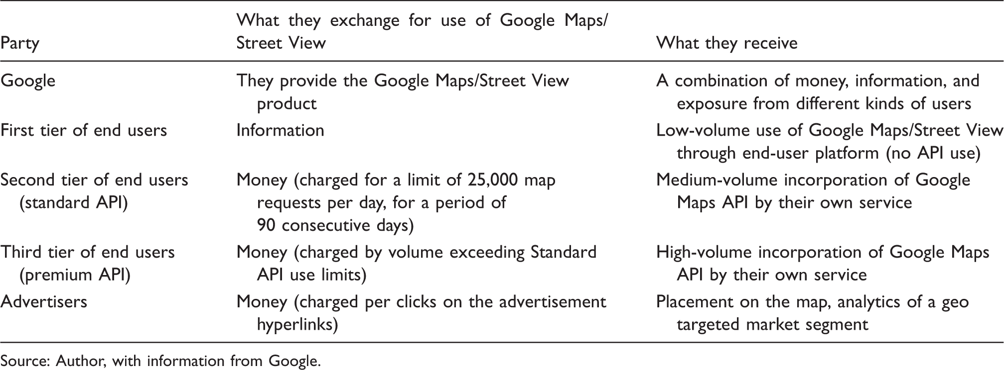
Source: Author, with information from Google.
A property regime for Google Street View.

Source: Author, with information from Google and Schlager and Ostrom (1992).
The role of privacy in Google Street View's property regimes
In the preceding subsection, I outlined two key issues in the creation of a property regime for Google Street View: property and privacy. The technological means of imagery collection and the very nature of the Google Street View platform make these concerns increasingly difficult to disentangle. In this context, the second concern, privacy, stems initially from the capture of Google Street View images as well as from the degree of invasion of someone's private sphere implicated by this action. Since this is a service offered in many countries, the property regimes shaping its commodification will vary across jurisdictions. These variations affect the product itself. For example, the information included on the map can change due to geopolitical considerations, and the various privacy regulations can restrict the collection of certain data. While there are many factors that may influence the local configuration of these property regimes, a key indicator is the relative weight given in each case to the privacy and property of the images and information involved in the triangular exchange (users – Google – advertisers) explained above.
In order to discuss the privacy implications of Google Street View imagery collection, it must be noted, as Elwood and Leszczynski have done (2011) that the geoweb has catalyzed a reconceptualization of privacy, as well as the associated social (and legal) struggles to define, maintain, and protect it. The fact that large datasets and imagery can be directly linked with particular physical locations creates a qualitatively different context in which to discuss what privacy means and how it is constructed. As Google Street View and other products in the geoweb have shown, large and networked datasets are becoming associated with spatial presence in ways that were unavailable to purely textual, tabular, or numerical data. This fundamentally alters the position and relations between actors who produce, access, use, or control these data (Elwood and Leszczynski, 2011). These relations are technological as much as they are institutional, political, and economic.
In the case of Google Street View, the production of this digital commodity must negotiate shifting conceptions of privacy, which are further transformed by the very act of imagery collection. In the course of collecting imagery, Google Street View vehicles physically navigate public thoroughfares. However, the public status of the information they collect is uneven and contingent. For example, Google has acknowledged that some Street View images may contain sensitive information. In light of this, the company announced measures to blur people's faces and vehicle license plates (Google, n.d.), as well as to comply with individual, community and government requests to omit certain locations from Google Maps and Google Street View (Google, n.d.; IT Security Editors, n.d.).
Furthermore, governments often submit content takedown requests to Google based on a range of criteria. While technically subject to legal oversight, it is Google that executes the content removal. The all-encompassing image capture of Google Street View combined with the power of discretionary removal that ultimately lies in the hands of Google have made privacy a major point of contention regarding the operations of this service in a number of countries. The privacy concerns that began with the collection of imagery intensified in 2010 when Data Protection Authorities in Ireland and Germany pressed Google to admit that in the course of their operations, Google Street View cars also collected information about private wireless networks (Google, 2010), such as router identifiers (SSIDs), computer MAC addresses, and even emails and browsing content in the case of unencrypted networks (Stroz, 2010). Google Street View has thus been identified as a threat to privacy and received renewed scrutiny around the world through government investigations and private lawsuits (Electronic Privacy Information Center, 2010).
These incidents have highlighted two aspects of privacy associated with the production of Google Street View: the collection of the images themselves, and the collection of wireless network data that takes places during image capture. These two aspects cannot be readily separated since the technology used for navigation purposes and image collection contained the code that collected wireless network data (Stroz, 2010). According to Google, their vehicles collected both types of data from 2006 until May of 2010, when they allegedly stopped this practice (Google, 2010).
In the United States, there have been private and class action lawsuits from parties who see Google Street View's imagery collection as a breach of privacy (Geissler, 2012). This concern over image collection has been compounded with responses focused on the wireless data collection. European countries have been the most vocal against both types of data collection. For example, there has been public outcry and massive removal requests in the UK and Germany. In Greece, the Czech Republic and Austria, data protection authorities temporarily banned collection to allow further review (Electronic Privacy Information Center, 2010; Geissler, 2012).
In light of these accusations in the US and the EU, Google argued that their cameras capture the same images that any passerby on the street would be able to see. However, most Street View cameras stand nine-feet tall, mounted on top of fast-moving vehicles, have 360-degree vision and produce high-resolution images that can be augmented by zoom. Critics argue that the combination of these features means that “most Street View imagery is created in a way that exceeds normal human capability” (Geissler, 2012: 903), concluding that it should be considered in a different bracket from ordinary public view.
With regard to imagery collection, the courts in Germany and the United States have been asked to decide whether Google Street View's image collection violates individuals' right to privacy. While the plaintiffs' claims have been dismissed in both countries, Geissler points out that there is an underlying contrast in how the right to privacy has been construed in each jurisdiction. In the United States, tort law places a much higher burden on private citizens to protect their own privacy (Geissler, 2012: 926). In Germany, “courts have interpreted [text in the German constitution] to imply a right to privacy that not only encompasses an affirmative government obligation to protect this right, but one that also constrains private parties' interactions with other private parties” (Geissler, 2012: 917). While Google vehicles continue to operate in Germany, the company reported that as of November 2014 they are not engaged in the collection of Street View imagery for public display, and only use it to improve Google Maps (Google Deutschland, 2014).
The privacy issues raised by the collection of imagery are further complicated by the associated collection of wireless communications data by Google vehicles. While these are developing in different ways across several jurisdictions, they highlight how the property regimes of digital information often transcend both property rights considered in isolation and the regulatory frameworks that govern any one of the inputs into new informational products. The integration of debates on privacy, ownership, and the commodification of geographic information is crucial to understand the generation of value by products such as Google Street View. How privacy is conceptualized, debated, and resolved plays an important role in how informational commodities are produced and commercialized. Along with the allocation of rights of access, use and ownership of Google Street View images, the particular constructions of privacy shaped by variegated legal challenges across jurisdictions contribute to construct the property regimes governing the production and appropriation of value though this product.
Conclusion
The analysis of Google Street View presented in this article applies Schlager and Ostrom's property regimes conceptual schema (1992) to explore an instance of the commodification of geographic information on the Internet. This analysis represents an extension of the property regimes schema by considering the challenges of digital information to the allocation of property rights and by focusing on the role of technologies in the transformation of legal protections. Furthermore, by incorporating the discussions on privacy with the allocation of property rights, this analysis brings into discussion the different values and logics (such as privacy) that have become increasingly intertwined in the commodification of digital information. Finally, by focusing on the transition from printed maps to digital maps and illustrating the emergence of new property regimes in the case of Google Street View, the article highlights how the characteristics of geographic information and its technological developments affect its new possibilities for its commodification in digital networked environments. The framework presented here can be deployed productively to examine other geographic information platforms (such as Bing Maps or OpenStreetMap) and understand the commodification of different types of information (such as satellite, crowdsourced, and health data).
In a broader context, the arguments in this article contribute to a political economy of geographic information on the Internet. This has been characterized by the reduction of the role of the state in the “cartographic project,” a process which has been accelerated by neoliberalization (Leszczynski, 2012). In combination with technological changes such as digitization, the movement away from state-centric cartography towards an expanding geographic information ecosystem is necessarily implicated in the redistribution of power dynamics between the state and other actors. It is at this juncture that we should understand and analyze the emergence of a digital economy of geographic information and its expansion on the Internet through processes of commodification. At a time when evermore information is becoming digitized, and much of it commodified, it remains a necessary task to conduct increasingly granular analyses of the production of value through information and understand their meaning within broader social transformations.
Footnotes
Declaration of conflicting interests
The author(s) declared no potential conflicts of interest with respect to the research, authorship, and/or publication of this article.
Funding
The author(s) disclosed receipt of the following financial support for the research, authorship, and/or publication of this article: The research and writing of this article were undertaken with the support of the UC MEXUS-CONACYT Doctoral Fellowship.