
Abstract
The location of the national capital is frequently contentious in domestic politics. Almost 30% of countries house their capitals outside of their largest city and 11 countries have relocated their capitals since 1960. This paper argues that locating the capital outside of the largest urban center may reduce civil conflict by limiting the ability of any single faction to dominate the government. When the government is less afraid of large urban populations in the capital, it is better able to appease multiple factions. Cross-national evidence supports this argument in that locating the capital outside of a major city is associated with a significant reduction in both violent and non-violent civil conflict.
Introduction
In August 2014, President Cristina Fernández de Kirchner of Argentina suggested that it may be time to relocate the capital from Buenos Aires to Santiago del Estero, a city with only 250,000 people in the interior of the country (Romero, 2014). The announcement was widely viewed as an attempt to outmaneuver political competitors and appease the interior provinces which have long viewed Buenos Aires as a separate and privileged part of the country.
The case of Argentina is in no way unique. In a host of cases, including the US, Brazil and Australia, the capital was located outside of a major metropolitan area in an effort to appease rivalries among geographically centered political factions. This paper argues that locating the capital outside of the largest urban area may reduce civil conflict by limiting the control of the largest urban area over the government and, thereby, making the government more responsive to factions outside the largest urban area of the country.
The empirical section analyzes the relationship between capital location and civil conflict and finds that having the capital outside of the largest urban center is a significant predictor of lower occurrence of civil conflict.
The paper proceeds in three sections. In the first section I outline a theory of why there may be a relationship between capital location and civil conflict. In the second I provide a preliminary empirical investigation into the relationship between capital location and civil conflict. In the last section I conclude.
Capital location and civil conflict
Nearly 30% of countries have their capital located outside of their largest city. In most of these countries, there are two competing urban centers or regions of the country. In the case of Canada, the US, New Zealand, Brazil, Nigeria and Pakistan, locating the capital outside of a major urban area was a compromise between rival factions that were geographically concentrated. Even in cases where there are not two competing urban centers, the primary axis of political competition is often between the largest city and populations outside of that city (Myers and Dietz, 2002). For example, the eventual choice of making Washington DC the capital of the US was very much the result of efforts to appease both the industrial North and the slave-owning agricultural economies of the South.
The argument of this paper is that if the government is located outside of the largest urban area, it will be less dominated by the interests of the largest urban area, and better able to appease multiple factions and therefore reduce civil conflict. The argument rests on the assumption that governments are more responsive to the population in the capital city due to the ability of urban populations to topple the government. If the government is not dominated by a single political faction (i.e. the urban population of the largest city) then the government may be more responsive to competing factions. This broader responsiveness may lend itself to forms of power-sharing that reduce the potential for civil conflict.
The assumption that urban populations in the capital city are able to exert control over the government (disproportionate to their share of total population) is supported by a range of existing research. Arend Lijphart’s work on consocialism discusses the relative advantage to factions that live in or near the seat of government in regards to influencing national politics. Grofman and Lijphart (2002) see this advantage as a possible reason why in many modern democracies (e.g. US, Norway, Brazil) the population of the capital is underrepresented in the government (i.e. to offset the advantage of living in the capital). 1 Similarly, in the seminal work of Bates (1981), the author documents how dictatorships in Africa are willing to exploit their rural populations so as to subsidize the population in the capital because the primary threat to the dictator’s survival comes from the urban population. Empirically, Campante et al. (2013) find that conflict is more likely to be successful in dislodging a non-democratic government when it is closer to the capital city. 2 A number of authors have also noted that for one faction to win a civil war within a country, it is almost always necessary to capture the capital city (Gugler, 1982; Huntington, 2006). This may also increase the leverage of factions located within the largest urban area if the capital is the largest urban area.
Case studies of countries that have shifted their capitals also support the assumption that governments may be forced to respond to the interests of the capital city when the population of the capital city is large relative to the population of the rest of the country. The immediate impetus for the US moving its capital out of Philadelphia was that when an angry mob of pensioners convened outside an early congressional session, the governor of Pennsylvania sympathized with the mob and refused to use force to remove them. The government did not want to be subject to the will of one faction in the country (e.g. angry pensioners in Pennsylvania). Therefore, the government established a new capital in a city created for that purpose (Washington, DC).
The potential for urban uprisings is a common motivation for moving the capital out of the largest city, though not a reason that leaders tend to publicly admit to. In the cases of Myanmar 3 and Kazakhstan there is no convincing state-sponsored explanation for recent capital shifts out of major urban areas. However, in both cases, the threat of urban uprisings is a plausible explanation (Schatz, 2004). 4 Similarly, government officials in Iran have recently suggested that it may become necessary to move the government out of Tehran because of fears of earthquakes. However, it is believed that the fault lines may be a cover to move the government to an area that is less susceptible to popular uprisings (The Telegraph, 2009).
In other cases, countries have chosen to locate their capital outside of the largest urban area of the city in order to not advantage that urban area over the rest of the county. In these cases, the capital is often located in a small or newly built city in an underdeveloped region of the country in order to be outside of any competing urban areas or geographic regions. Again, in the case of the US, shifting the capital out of Philadelphia was an effort to avoid control by the local urban population but also to avoid being located in the strong holds of either of the major competing factions of the country at the time: the industrial North or the slave-owning agricultural South. Similarly, in Brazil, the capital was shifted to the newly constructed Brasilia in the interior of Brazil to develop the interior of the nation; however, the initial impetus for moving the capital was a constitutional provision that said the capital should be moved outside of Rio de Janeiro to keep that city from dominating the national government. Similarly, Canada (Ottawa) and Australia (Canberra) located their capitals in remote areas of their respective nations ostensibly for development purposes. However, in both cases the initial impetus was the increasing rivalry between the large cites of Toronto and Montreal in Canada, and Sydney and Melbourne in Australia (Schatz, 2004).
Thus, the primary motivations for shifting the capital of a country out of the largest urban area is to limit the control of the largest urban area over the government. The argument of this paper is that by doing this, the government may be able to better manage the competing interests of geographically concentrated political and economic interests through compromise or forms of power sharing. This, in turn, will lead to a lower likelihood of civil conflict. While this makes intuitive sense, recent work by Campante et al. (2013) and Campante (2014) has argued that isolated capitals lead to unaccountable governments and misgovernance through a very similar mechanism as the one proposed in this paper. Campante et al. (2013) model the relationship between capital cities and governance based on the assumption that incumbent elites are constrained by the threat of insurrection and that when the threat of insurrection comes from groups located further from the capital the threat is smaller. They argue and find evidence that isolated capitals are associated with misgovernance in the case of non-democracies because the government is less constrained. Campante (2014) finds that isolated state capitals in the US are associated with higher levels of corruption, and find evidence that this relationship is driven by voters paying less attention to state politics when they live further from the state capital. Thus, isolated state capitals are allowed to operate with less accountability from the public than less isolated state capitals.
In both of these papers, whether in the US or in a cross-national setting, the authors argue that isolated capitals are associated with less accountability because more populated capital cities are able to exert pressure on the government. However, in the case of conflict, the relationship is less clear. This is because, as argued in this paper, increased responsiveness to the interests of the largest urban area may in fact decrease the responsiveness of the government to factions located outside of the largest urban area. In fact, there may well be a trade-off between accountability and conflict reduction involved in locating the capital outside of the major urban area.
This is especially true when we consider that many civil conflicts occur in isolated areas of the county. Fearon and Laitin (2003) argue that civil conflict is in part the result of factions living outside of the government’s control; for example, in mountainous terrain. Their argument is that these factions are able to exist as a result of states that are unable to control these factions due to low state capacity and/or rugged terrain that allows the rival factions to continue to operate. Similarly, Buhaug (2010) creates a model in which the probability of conflict in an area increases as distance from the capital increases because extending state capacity further from the capital is costly. Empirically, Buhaug and Gates (2002) find evidence that civil conflicts are more likely to occur at greater distances from the capital. The argument here is that while locating the capital in the largest urban area of the country may increase government accountability to this large urban population, and therefore increase overall accountability (as suggested in Campante et al. (2013) and Campante (2014)), it may also reduce responsiveness to other geographic areas and therefore increase the probability of civil conflict.
Empirical relationship between capital location and civil conflict
The relationship between capital location and civil conflict is difficult to test empirically for a number of reasons. First, the number of countries with their capital located outside of the main urban area is relatively small: 28 countries in the dataset have their capitals located outside of their largest city. Second, as discussed above, the most common motivation for locating the capital outside of the main urban area is to appease rival cities or geographical factions. It seems reasonable to expect that countries that locate their capital outside of the main urban area are more likely to institute other policies to reduce conflict as well. On the other hand, countries that locate their capital outside of an urban area are likely to have a higher initial potential for civil conflict because otherwise they would not have chosen to take this step. From a theoretical perspective, these biases move in opposite directions, and it is unclear which one would dominate. However, there is clearly a selection bias in terms of which countries choose to locate their capital outside of the largest city. Third, there is inadequate overtime variation to use a time-series analysis of capital location. Only 11 countries have shifted their capitals since 1960 (eight of these to smaller cities).
Because of this, the goal of the analysis is not to establish a causal relationship, but to establish whether there is a cross-sectional correlation between locating the capital outside of the main urban area and a reduction in civil conflict.
For the baseline analysis, the dependent variable for civil conflict comes from the Major Episodes of Political Violence (MEPV) dataset (Marshall, 2016). The outcome is either binary for whether the country has experienced an episode of violent civil conflict since 1946 or a count of the number of years between 1946 and 2015 during which there was violent conflict. Violent conflict is defined as the following: “Major episodes of political violence are defined by the systematic and sustained use of lethal violence by organized groups that result in at least 500 directly-related deaths over the course of the episode” (Marshall, 2016: 2). Thus, for the binary variable, countries that have experienced at least one of these events since 1946 are coded as 1, and 0 otherwise. For the count variable, the number of years during which there was conflict are summed.
While the dependent variable includes civil wars and civil conflicts, the results are the same if only civil conflict or only civil wars are used. China is the only country to have their capital located outside of the main urban area and to have a civil war in the time period analyzed. Even in the case of China, one could argue that Shanghai (which was the largest city in the country at the time) was not actually part of China as it had been administered as an international settlement controlled by the British, Americans and French for most of the period prior to the civil war.
The independent variable of interest is binary and coded as 1 if the capital is outside of the major urban center, and 0 otherwise. Control variables for country area, total population, percent of the country that is urban, whether the country is oil producing (defined as at least one-third of export revenue from fossil fuels), GDP per capita and the population of the largest city come from the World Bank Indicators dataset (World Bank, 2017). These variables are coded as their value in 1960 (earliest year of data across countries), or as the mean of the years from 1960 to 1965 if there is large variation within this time period. This was in order to not control for post-treatment variables. However, coding for current values does not substantively affect the results. Controls for ethnic fractionalization 5 and elevation (which is adapted from the work of A.J. Gerard at the World Bank) are also included and come from Fearon and Laitin (2003). These controls have either been previously associated with conflict in existing literature or directly relate to the size of the capital city (total population, population of largest city and percent urban). In addition, region fixed effects are included in all models.
The base model specification is:

where the dependent variable is a dummy for whether a civil conflict occurred between 1940 and 2008,
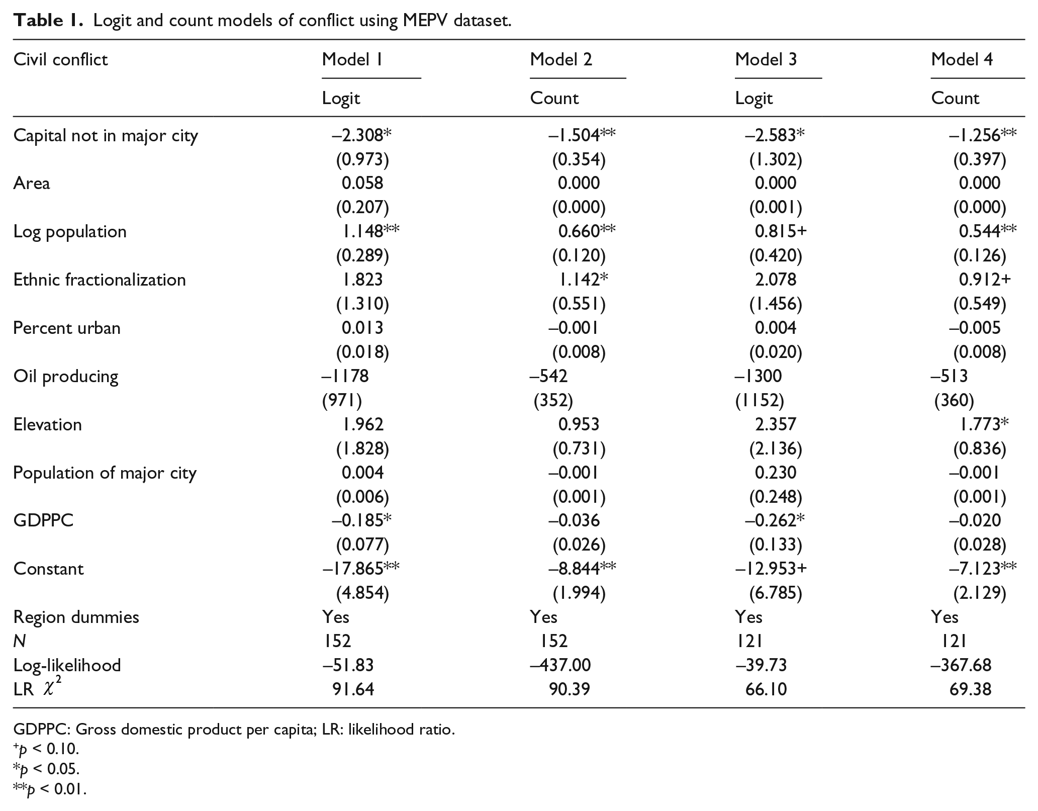
Model 1 in Table 1 is a logit model using the binary measure of conflict and the full sample of countries for which there is available data. Note that some countries are excluded from the analysis because of lack of data availability for the full set of control variables. Model 2 is a count model with the full sample. Model 3 is a logit model using a reduced sample of countries that does not include Western democracies and all countries that changed their capitals since 1960. These observations are removed because it is possible that despite the region fixed effects, the results are still being driven by Western democracies such as the US, Australia, Canada and Switzerland, which all have their capitals outside of the primary urban center. There are also 11 countries that shifted their capitals since 1960 and eight of these countries shifted their capitals to smaller cities. These 11 countries are also removed. Tables of countries with their capital outside of the largest city, as well as those that have shifted their capital since 1960 and those that are removed from the sample in Model 3 and Model 4, are provided in the online Appendix. Model 4 uses a count model and the same reduced sample as in Model 3.
Logit and count models of conflict using MEPV dataset.
GDPPC: Gross domestic product per capita; LR: likelihood ratio.
p < 0.10.
p < 0.05.
p < 0.01.
In all models, we see that the coefficient on whether a capital is located outside of the largest urban center is significant at least at the 95% confidence level and in the predicted direction. Countries that locate their capital outside of a major urban area are significantly less likely to have experienced a civil conflict over the period of analysis.
As a robustness check of the main results, Table 2 uses the Nonviolent and Violent Campaigns and Outcomes (NAVCO) Dataset (Chenoweth and Lewis, 2013) instead of the MEPV dataset as the dependent variable. The models are the same as in Table 1, where Model 1 and 2 include the full sample with a logit and count model respectively, and Model 3 and 4 use the reduced sample and logit and count model respectively. We again see that all results are negative, as in Table 1. However, in Model 3 (logit model with Western democracies and countries that shifted their capital since 1960 removed) the coefficient on Capital Location does not reach traditional levels of significance (p = 0.150). In the online Appendix, I use the same model specifications and the Uppsala Conflict Data Program (UCDP) dataset on violence and find a negative and significant relationship between locating the capital outside of the largest city and violent civil conflict in all models.
Logit and count models of conflict using NAVCO dataset.

GDPPC: Gross domestic product per capita; LR: likelihood ratio.
p < 0.10.
p < 0.05.
p < 0.01.
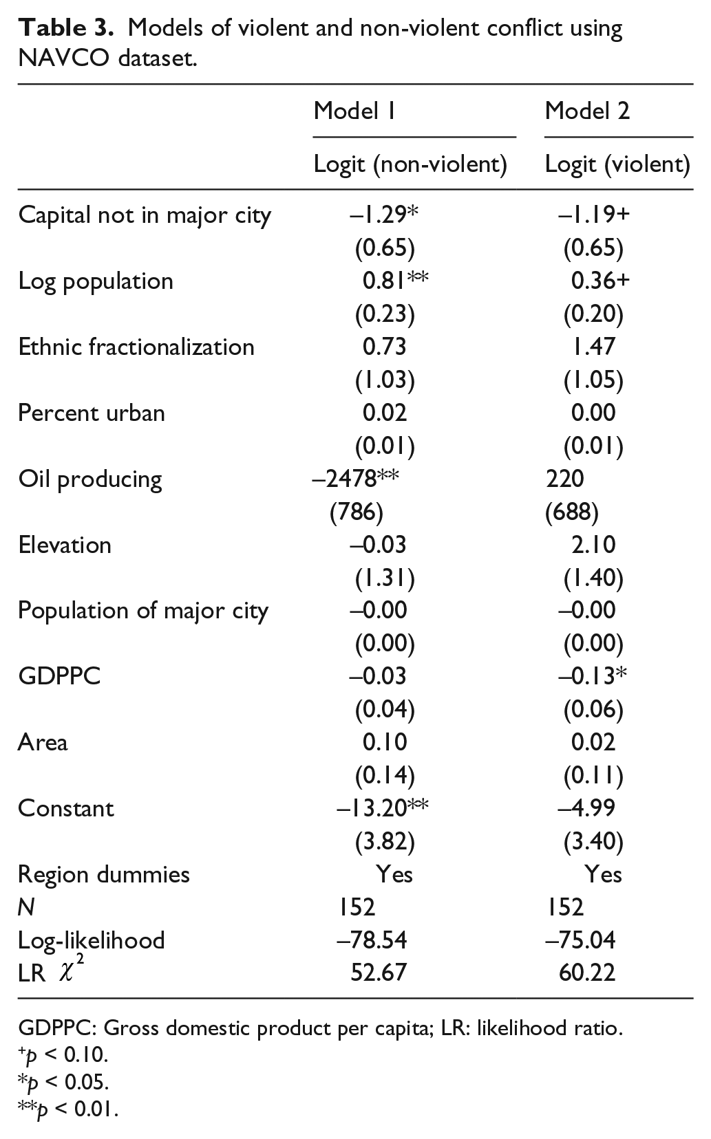
The NAVCO dataset contains separate coding for conflicts that are violent and conflicts that are non-violent, where violent conflict is defined as the following: “Campaigns where a significant amount of violence occurred are characterized as violent. Violent resistance involves the use of force to physically harm or threaten to harm the opponent” and “Nonviolent resistance does not directly threaten or harm the physical well-being of the opponent” (Chenoweth and Lewis, 2013: 3). The distinction between non-violent and violent conflict is interesting in that non-violent conflict tends to be urban. The models in Table 2 considered violent and non-violent conflict jointly.
Table 3 analyses the measures of violent and non-violent conflict separately. Model 1 uses a binary variable for having at least one non-violent conflict during the period of analysis, and Model 2 uses a binary variable for having at least one violent conflict during the period of analysis. Note that count models were not used here, as determining the start and end date of non-violent conflicts was not the goal of the NAVCO dataset (the NAVCO dataset instead focuses on peak years of campaigns as this is generally easier to determine).
Models of violent and non-violent conflict using NAVCO dataset.
GDPPC: Gross domestic product per capita; LR: likelihood ratio.
p < 0.10.
p < 0.05.
p < 0.01.
The coefficients are negative and significant at least at the 90% level in both models. This indicates that countries with their capital outside of their largest city have fewer instances of violent and non-violent conflict. This suggests that the association between capital location and conflict is not limited to violent or non-violent conflict, which is important as previous research has found that non-violent conflict is more likely in urban areas (Chenoweth and Stephan, 2011). Had the results only held for non-violent conflicts, then this may have indicated that the reduction of conflict is occurring through a different mechanism whereby large urban populations are less likely to engage in conflict when they are outside the capital city because they have a lower probability of success. The fact that the result holds for both violent and non-violent conflict indicates that this alternative mechanism is not driving the results.
Conclusion
This paper examines the relationship between capital location and civil conflict. The subject is one that has received limited attention in the political science literature, despite being an important political issue in countries around the world. The paper argues that locating the capital outside of the largest urban area may reduce civil conflict by decreasing the control of the largest urban center over the government, and increasing the government’s responsiveness to multiple factions outside of the largest urban area.
The empirical results of the paper find a correlation between locating the capital outside of the major urban area and a reduction in civil conflict. The results are only correlational, and there is likely a selection bias in that countries that chose to locate their capital outside of the major urban area may have also made other decisions to reduce conflict, or may be more prone to conflict between competing factions. For example, many of the countries that have their capital outside of the largest urban area also have federalist systems, such as Australia, Canada, Brazil, Switzerland, Pakistan and the US. While removing the Western democracies from the analysis should help protect against the possibility that these countries are driving the results, there is still a basic selection issue in how countries choose to locate their capital that will need to be addressed in future work.
Despite these limitations, the results describe a relationship that deserves further attention. Future work will need to use a more qualitative approach, or focus on an identification strategy such as an instrumental variable approach to better understand the causal chain between capital location and civil conflict.
Footnotes
Declaration of conflicting interests
The author(s) declared no potential conflicts of interest with respect to the research, authorship, and/or publication of this article.
Funding
The author(s) received no financial support for the research, authorship, and/or publication of this article.
Notes
Carnegie Corporation of New York Grant
This publication was made possible (in part) by a grant from Carnegie Corporation of New York. The statements made and views expressed are solely the responsibility of the author.
References
Supplementary Material
Please find the following supplemental material available below.
For Open Access articles published under a Creative Commons License, all supplemental material carries the same license as the article it is associated with.
For non-Open Access articles published, all supplemental material carries a non-exclusive license, and permission requests for re-use of supplemental material or any part of supplemental material shall be sent directly to the copyright owner as specified in the copyright notice associated with the article.