
Abstract
Combining different diverse data on human and environmental history during the Anthropocene is an extremely challenging task, particularly, if one wants to compare written or cartographic data with a whole range of environmental data recorded for more than the past 200–300 years. In this article, our objective was to demonstrate that one of the keys to facilitating syntheses for the study of forest landscape dynamics was to conduct a thorough investigation into the historical phenomena of modernization. We believe that a comprehensive understanding of the advancements in post-enlightenment thought and contextualizing them within the evolution of the state apparatus during the 18th and 19th centuries will empower us to formulate new research questions and broaden our understanding of the mutual relations between nature and humans in the past.
Keywords
Introduction
Aim of the study
The Anthropocene denotes an era characterized by dynamic, human-induced environmental changes (Lewis and Maslin, 2015). With the belief that humans have significantly influenced and continue to influence environmental changes, this article centers on the essential question of how to comprehensively portray past environmental changes. This study delves into the planning of research and the selection of suitable analyses/proxies to identify and discuss human influence in the paleoecological and dendrochronological records of the past. In addition, it explores methods to effectively illustrate the relationship and the clear component of connectivity between the present and future. To answer these questions, the focal point of our examination revolves around forest landscapes, which have played a vital role in providing diverse ecosystem services to humanity across various epochs.
Why focus on forests? First, they are the most structurally and functionally complex terrestrial ecosystems, consisting of many interconnected subsystems functioning at different temporal and spatial scales (Baluška et al., 2010). Furthermore, they have withstood the test of time, adapting to diverse environments over the past 380 million years through intricate interactions among their constituent organisms (Hagen et al., 2021). By transforming the planet’s ancient atmosphere, the plants within the forest have enabled the existence of animal life forms, including humans. Throughout history, forests have served our ancestors as shelters, places of worship, and sources of vital resources. They have played a significant role in the rise of civilizations and continue to provide a wide range of raw materials, food, tools, fuel, weapons, clothing, and building materials. In addition, forests, with their trees and other plants responsible for producing roughly half of the world’s oxygen, play a crucial role in maintaining the Earth’s ecosystem, regulating atmospheric quality, safeguarding against flooding and erosion, and moderating the climate (De Frenne et al., 2019). Despite human efforts to manage forests through various techniques, the pursuit of simplification has resulted in the loss of their wildness and natural structure (Huang and Kong, 2016; Łuców et al., 2021). When the first European settlers in North America saw the immensity of the wilderness there, they assumed that it would take thousands of years to exploit it. But it only took less than 350 years for the landscape of the continent to change dramatically (Jordan, 2010). We do not know the ultimate consequences of our actions, and our relationship with the forest is often characterized by exploitation (Stauffer, 1975). Although attempts have been made to control natural processes and ensure a steady supply of resources through forest management models, it is crucial to recognize that it is no longer really an old-growth forest, but only its artificial prosthesis—a stand of trees. Studying past forest landscapes allows us to comprehend their original state, thereby enhancing our understanding and facilitating their natural adaptations to todays climatic and edaphic conditions, or potential restoration efforts wherever feasible.
In this article, we particularly focus on the past 200–300 years—the era marked by the most dynamic development of human influence on the environment. Through their actions, our ancestors have played a significant role in driving climate change, the decline of biodiversity, the extinction of numerous species, or the increased vulnerability of ecosystems to various disturbances (Malhi et al., 2016; Newman, 2019; Schimel et al., 2013). These transformations not only impact the environment itself but also, more significantly, impact the quality of human life, a reality that many still fail to acknowledge (Cardinale et al., 2012). Significantly, all these processes are characterized by their multilayered nature and also long-term impact, necessitating the use of appropriate research methods applicable to various scientific disciplines. To comprehensively understand the changes in the ancient environment, we are therefore forced to conclude on various archives—both those written and those created by nature. However, it should be emphasized that our approach to the aforementioned subject is characterized by the intention to interpret these processes through the perspective of past modernizing changes. We firmly believe that we cannot properly interpret the long- and short-term processes that took place on Earth during the various phases of the Anthropocene if we do not know the ideological motivations behind the heads of state of the Enlightenment states (and especially the officials they represent at various levels). In this context, we recognize a distinct connection between what took place “yesterday” and what is happening “today” and what will happen “tomorrow.”
Therefore, the study presented here should be considered as a methodological research exploration aligned with the ongoing scientific projects dealing with the anthropogenic transformation of the environment in the Polish territories during the period of Enlightenment. Hence, the Kampinos Forest has been selected as the primary research laboratory. We aim to outline the main directions of our scientific discussions, emphasizing the methodologically significant elements that have aided us in elucidating the overall vision of our research and interdisciplinary cooperation.
Kampinos Forest—disturbed landscape
The history of the Kampinos Forest dates back to the time of the last Ice Age when the receding glaciations and the flowing pre-Vistula River (25 km wide) gave rise to a diverse landscape of an alternating belt of dunes and marshes. These two enduring elements of the local landscape have significantly influenced the subsequent fate of its use in the past. The natural value of the Kampinos Forest was particularly emphasized by its pioneering researchers Roman and Jadwiga Kobendza (Kobendza and Kobendza, 1945). They emphasized that despite significant anthropogenic influences, the Kampinos Forest has managed to preserve its natural character in several areas. It should be remembered, however, that in the 18th and 19th centuries, it was primarily a commercial forest (Heymanowski, 1964). The people inhabiting the area faced numerous hardships due to the presence of sand dune belts and inaccessible swamps, resulting in challenging circumstances of severe summer droughts and spring floods (Kobendza and Kobendza, 1945). In addition, the area was plagued by armed conflicts in the 17th, 18th, 19th, and 20th centuries. The challenging environmental conditions prevailing in the region prompted extensive interventions in the wilderness area, including the reclamation of the swamp belt. Therefore, it is accurate to assert that the environment of the Kampinos Forest has been subjected to disturbances and pressures on the ecosystems throughout the past centuries.
Thanks to the dedicated efforts of Roman and Jadwiga Kobendza, Kampinos National Park (KNP) was established in 1959. It is the second largest national park in Poland and spans over a length of more than 40 km from west to east in the Warsaw Basin in the old channel of the Vistula River. It covers an area of 400 km2, of which 73.3% is occupied by tree stands. The most dominant tree species in the stands is Scots pine (Pinus sylvestris) accounting for about 69%, Black alder (Alnus glutinosa) about 12.5%, oak (Quercus spp.) about 10.3%, and birch (Betula spp.) about 6.4% (Biuro Urządzenia Lasu i Geodezji Leśnej, 2002). The KNP is renowned for its dune and wetland belts, contributing to the preservation of ecological diversity (Zgorzelski and Pawłowska, 2003). Scots pine is primarily found in dune belts, whereas Black alder thrives in wet habitats, such as aeolian depressions and wetlands associated with river valleys.
A closer examination of the Kampinos Forest (hereafter referred to as KF; we will use this term when describing the historical periods) reveals a history of persistent ecosystem disturbances caused not only by natural factors but also mainly by the ever-increasing human pressure (Rutkowski et al., 2005). The forest endured not only extensive clearing by barbarian tribes during the Roman influence period but also constant pressures from grazing, logging, and production of tar and charcoal during the Middle Ages and Early Modern Times (Woyda, 2005). Similar to the surrounding forests of central Poland, it experienced a decline in local biodiversity due to the extermination of the aurochs (Bos primigenius) in the first half of the 17th century (Dymek, 2007). With the development of the settlement network during the Middle Ages and Early Modern times, the encroachment of people into the forest grew steadily. Thus, by the late 18th century, numerous forest settlements had been established (Heymanowski, 1969a). However, the pivotal moment for local forest ecosystems occurred during the transition from the 18th to the 19th century. The implementation of forest management practices, planned land reclamation efforts, rapid urbanization, and the profound impact of two world wars in the early 20th century shaped the forest into its present day form (Zielony, 2004). As previously mentioned, the landscape of the KF comprises alternating strips of inland dunes and wetlands, remnants of the ancient course of the Vistula River during the Vistula glaciation. This distinctive and valuable wetland system has been significantly disrupted by human activities associated with land reclamation efforts in the 19th century (Okruszko et al., 2011).
Ecosystems undergo various types of stresses and disturbances (e.g. fires, volcanic eruptions, droughts, floods, hurricanes, insect outbreaks, etc.). Throughout history, however, it is human activity that has had a profound impact on the landscape, interfering with its structure and posing a significant threat to it (Battisti et al., 2016). Moreover, humans have also been responsible for creating entirely new landscapes (Ellis, 2021; Ellis et al., 2021; Słowiński et al., 2021).
In the case of areas such as the KNP, it is noteworthy that disturbances impacting wetlands, including peatlands (Figure 1), are of significant importance. These ecosystems exhibit very high sensitivity to alterations in the local environment (Rydin and Jeglum, 2013; Tobolski, 2003). The peatlands within the areas experienced disturbances that result from both natural and anthropogenic factors. These processes often overlapped, such as drainage activities that transformed the peatlands into meadows and agricultural land. Additionally, it is crucial to consider factors such as forest fires, climate change, peat cutting, changes in land use within the ecosystem’s catchment area, or disturbances caused by animal activities (e.g. insect outbreaks). Such an approach aligns with recent studies that emphasize analyzing the biography of the forest landscape (Kirby and Watkins, 1998; Samojlik et al., 2020; Short, 2022).
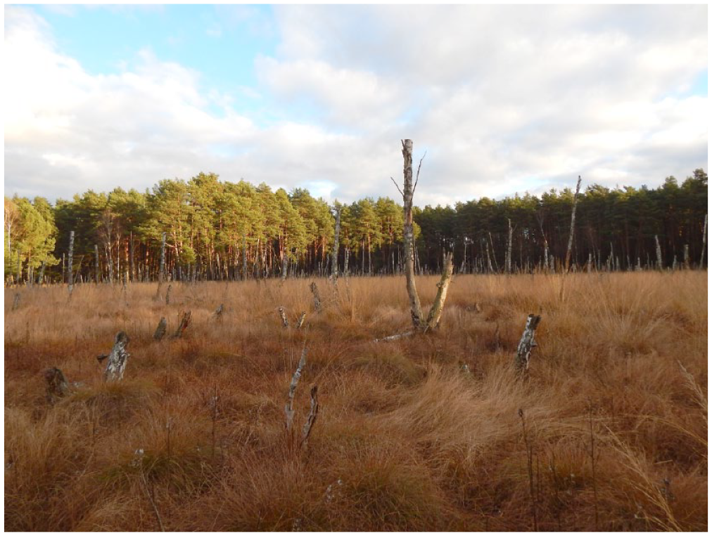
The Okrąglak peatland inside the KNP. The total length of the core with biogenic sediments at this site reaches a depth of more than 2 m. Picture taken in October 2021 by D. Łuców.
In general, wetlands in the KNP underwent significant alterations primarily due to drainage activities. These disturbances were associated with modifications in water conditions in the wetlands and changes in the use of these ecosystems. As a sequence, the water table was lowered, leading to rapid landscape drainage, resulting not only in a cascade of subsequent changes, for example, in vegetation cover and soil organic structure (Jasnowski, 1972) but also in the disappearance of the peat accumulation process (Tobolski, 2003).
Wetlands have been and continue to be susceptible to alterations in land use within their watersheds. Deforestation leads to significant changes in the functioning of peatland ecosystems, for example, increases in water level fluctuations, changes in nutrient availability, and consequent modifications in local vegetation often favoring the dominance of vascular plants over mosses (Ireland and Booth, 2012). Forest management practices such as selective felling or clear-cutting play a significant role in this context (Słowiński et al., 2019). The response of ecosystems to these disturbances depends on their type and resilience (Marcisz et al., 2015). For instance, deforestation near a small peatland can result in increased water levels, potentially leading to hydrological instability of the peatland (Słowiński et al., 2016).
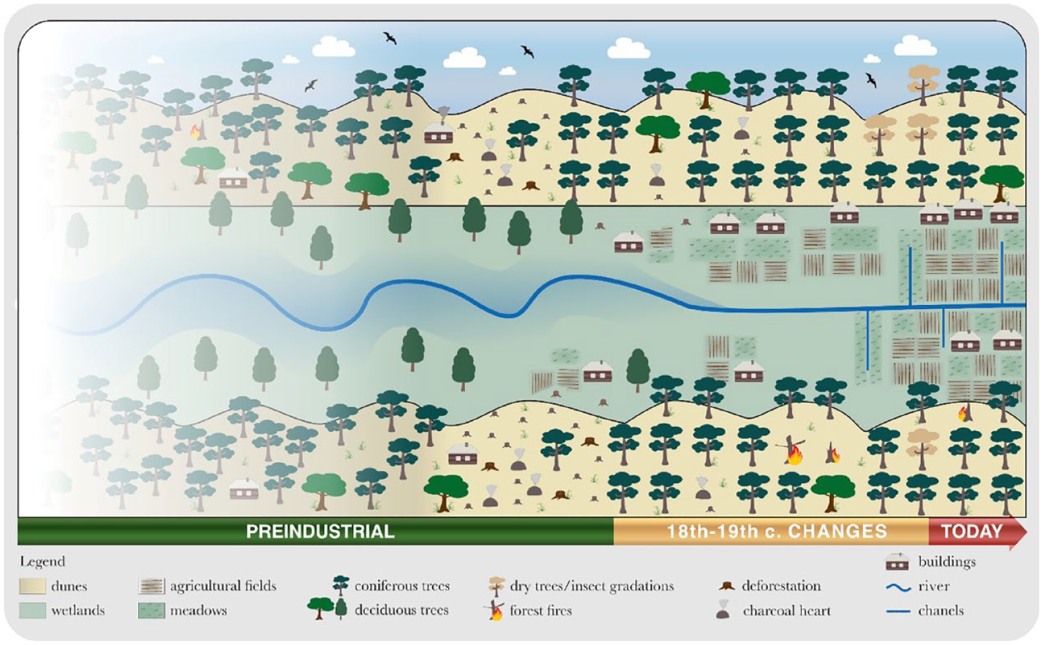
We hypothesize that some of the ecosystem changes that likely occurred in the KF over the centuries were influenced by natural factors or resulted from limited human activity. At this stage, it is important to acknowledge that significant cascading changes may have been triggered, particularly around the 18th and 19th centuries, with the onset of water disturbances and the subsequent implementation of forest management in the KF (Samojlik et al., 2013) (Figure 2). These changes must have had a significant impact on the nearby human communities, as they had to adapt to the rapid transformations in the surrounding ecosystems. Understanding these dynamics poses a major research challenge. It requires an interdisciplinary approach that combines not only historical-cartographic and paleoecological but also dendrochronological and genetic analyses. By adopting such a comprehensive perspective, we can gain insights into short- and long-term environmental influences of both natural factors and human activities.
The extent of ecosystem change in KF has varied considerably in the past. When analyzing the available data, the intensive human influence over the last 200–300 years is clearly visible. Due to only fragmentary written sources, the earliest history of KF (stands within the forest complex) is unclear. We assume that the area was difficult to settle due to the function of an alternating belt of dunes and marshes. Only the late 18th century contributed to the emergence of forest settlements, which later often turned into regular villages.
Sources
To investigate the environmental changes resulting from past modernization efforts, it is crucial to select a suitable study site. Hence, we have chosen the KF, which not only has preserved written and cartographic sources but also has numerous archives of nature in its territory (including more than 200-year-old stands of pine trees). In this theoretical and preliminary study, we rely primarily on the preserved plans for the area of the present KNP, which were originally part of the former KF. Through extensive archival research, to date, we have identified over 120 maps that relate (to varying degrees) to this former forest complex (AGAD—Central Archives of Historical Records in Warsaw). These maps cover the period from the late 18th century to around 1870 and originate from various chanceries operating by different states and forest offices (i.e. during the Prussian state period, Duchy of Warsaw, and later Russian occupation). Thematically, the identified maps address a wide range of issues including settlement, forest management, drainage, natural disturbances (floods and fires), demarcation of estates, etc. Since numerous written documents were lost during World War II, these surviving maps serve as invaluable sources of information.
The surviving maps provide a clear depiction of all the issues and processes discussed in this study. Accordingly, they serve as a valuable tool in understanding historical spatial arrangements of the ongoing modernization processes. By analyzing these maps, we were able to trace the main direction of the development of the KF landscape. Maps serve as an excellent tool for the dynamic recording of environmental, settlement, administrative, economic, and social changes. Maps make it possible to attempt to record changes in the social perception of a given period. Here, forest cartography plays a crucial role. It should be noted that in accordance with the spirit of the times, modernization in the 19th century aimed to tame nature, cultivate the land, and exploit the environment and its resources for society (Kizwalter, 2020; Staszic, 1815; Surowiecki, 1811). Nineteenth-century cartography provides an insight into the extent of settlement development and agricultural land use in the area of the study site. It also documents the evolution of the transport network, along with the construction of roads and railways (in the second half of the century).
Research approach—introducing the modernization
A significant transformation in man’s relationship with nature occurred through the establishment of the fundamental principles of Enlightenment science (Wulf, 2015). The adoption of the scientific method for understanding the natural world not only facilitated advancements in various scientific disciplines but also brought about a paradigm shift in how societies interacted with the environment. Enlightenment science was also a starting point for the dynamic development of technology. It is important to address the environmental consequences resulting from the changes brought about by the processes of modernization and industrialization during the transition from the 18th to the 19th century in the context of Polish territories. The chosen approach is thus to embed modernization in the Anthropocene as a distinct human causal factor. In other words, modernization, primarily aimed at improving the economies of the enlightened monarchies of the time, was a conscious human decision and action that, in conjunction with forest habitats (or the environment in a broader sense), resulted in the subjugation of nature. The proposed interdisciplinary methodological approach aims to highlight and propose a research perspective whose main objective was to focus on assessing the extent of environmental changes—from the occurrence of changes during the period of progressive modernization to the present day.
The studied area experienced a transitional period of modernization, albeit with a delay of several decades compared with Western Europe (Malanima, 2020). Although countries such as Great Britain, France, or the German states underwent an evolutionary process of ideas (Sieferle, 2001), the Polish lands witnessed a more revolutionary nature of modernization, which was closely associated with the establishment or enforcement of the Enlightenment state following the dissolution of the Polish-Lithuanian Commonwealth. The following three paths can be distinguished here, namely:
The full enforcement of a model of natural resource management in the state according to Prussian standards (the example of Greater Poland, the western part of the Polish lands).
The adaptation of the proposed model of environmental management to local legal conditions and traditions (the example of Southern Austrian Galicia).
The creation of its own way of managing environmental resources (Dutchy of Warsaw and later Congress Poland), based on the achievements of neighboring powers (France, Prussia, Russia, and the Habsburg monarchy) from scratch.
In this case, it is evident that both time and space played crucial roles because the establishment of forest management in the territories under Prussian and Austrian partitions commenced as early as the 1870s. In contrast, in the regions that were part of Congress Poland after the Congress of Vienna, this process did not occur until the early 1820s. This considerable divergence in time and space resulted in distinct patterns of environmental change and dynamics.
This period is commonly referred to as “industrialization,” signifying the entrance of societies worldwide into a phase of rapid industrial transformation primarily driven by the utilization of fossil fuels (Jedlicki, 1964; Kander et al., 2013). Industrialization, however, was rooted in a more intricate process known as modernization, that is, encompassing the development of various facets of life on a broad scale. This process influenced not only the economic and social domains but also extended to other functional realms of past generations, encompassing technological, ideological, organizational, and institutional changes. In the field of forest sciences, a significant milestone was the introduction of the so-called modern forest management, which should be considered one of the effects and elements of modernization (Fedotova and Loskutova, 2015; Hölzl, 2010, 2011).
Simultaneously, it is important to acknowledge that the industrialization and control of forests in modern European countries were preceded by a dynamic advancement of scientifically based forestry, which rationalized the principles governing the utilization and exploitation of forests for economic purposes. In this regard, it served as a significant argument for the decision-makers of the time, who relied on these principles to redefine the functionality of forests (Du Duhamel Monceau, 1764). The principles of forest management in Europe during that period were notably influenced by the German model of sustainable forest management (Germ. Nachhaltigkeit), emphasizing the rationalization of utilization and bureaucratization of structures (Stuber, 2008). In addition, the establishment of specialized forest services, the development of the foundations of professional forest education, the organization of the forest administration structures, and the provision of adequate material level (i.e. regular salaries and free housing) significantly facilitated the implementation of progressive changes in forest ecosystems around the world that can still be observed to this day.
One notable outcome of the Enlightenment era in the late 18th and early 19th centuries in the Polish lands was the dissemination and development of forest cartography (Olenderek, 2017; Olenderek and Mazur, 2020). The creation of detailed forest maps and atlases, primarily intended to inventory the successive stages of forest management, contributed to a significant shift in the conception of forest resource utilization. From that moment, forests were to be managed and subjected to the various phases of forest stand development and harvesting. The principle of silviculture in forestry management during that period revolved around the following three stages: “sowing, growing, and harvesting” (Bonan, 2019).
Modernization can be described as a transition from a primitive state to a more sophisticated one. It is a continuous process that encompasses economic, political, cultural, religious, and mental spheres (Sztompka, 2013). Regarding the modernization of forest management, each of the three regions of the Polish lands under Prussian, Russian, and Austrian rule followed distinct paths in terms of timing, as well as the involvement and influence of central authorities.
Forest management, as a result of modernization, not only brought about changes in the economic, social, and environmental aspects of the landscape but also caused significant environmental transformations. The concept of “forestry modernization” refers to the effort to introduce the German model of forest management, that is, a measure that modernizes forest exploitation, as well as the establishment of new bureaucratic relations and mechanisms aimed at unifying forest management, subjecting it to control and, above all, primarily generating revenue from it. The consequences of modernization transformations resulted in a disruption of hitherto functioning forest use at the expense of the rural population, while simultaneously consolidating the position of the state and landowners (Bonan, 2019). This abrupt shift from long-standing rural practices created conflicts, such as tensions between villagers and forestry officials (Popek, 2021; Szabó, 2023). The issue resulted from the fact that the forest was a symbol of wealth for many groups in the society. It was perceived as an extremely lucrative industry that progressively gained significance. On the one hand, this profitability stemmed from straightforward endeavors that yielded immediate gains, that is, the logging and trade of timber for both local consumption and export purposes. Nevertheless, the constant demand for certain export raw materials, such as potash, tar, and charcoal, sustained the artisanal basins. The predominant reliance on timber sales as a primary source of income, coupled with the isolated nature of artisanal practices, revealed the absence of standardized forest management regulations, particularly during the decline of the Polish state at the end of the 18th century. Thus, the local forest management rules that existed during that period (mainly in large private estates) confirmed the absence of an active and coherent state policy in the area of standardization or attempts to modernize this part of the economy or of regulations that could contribute to the introduction of modern forest management rules. In the late 18th century and the first decades of the 19th century, the concept of the use of forests in the Polish territories developed, and with it the view of the decision-making bodies (state and owners). The introduction of the first forest regulation plans, manuals, and other written instructions aimed at protecting forest areas demonstrated an effort to exert control and preserve forest landscapes. In Austrian Galicia, such solutions were adopted through a series of laws at the end of the 19th century, most notably the main Forestry Act of 1782 (Edicta Et Mandata Universalia Regnis Galiciæ Et Lodomeriæ, Lemberg, 1782). The cultivation of forests aimed to shape communities into valuable commercial or usable resources, ultimately fueling the progression of industrialization. The forests and their strict subordination to economic processes at the state level, thus, became a characteristic point of the accepted narrative that dominated the later decades of the 19th century, aligning with the official policies of modern European states.
Various consequences of the modernization processes during the 19th century
Forests modernization and Congress Kingdom under the Russian rule
By the late 18th century, the Polish lands underwent tremendous transitions. First, the Polish state ceased to exist as it was partitioned by its following neighbors: Prussia, Russia, and Austria in 1772, 1793, and 1795. Consequently, each annexed region experienced distinct political, social, and economic changes. The disappearance of the Polish-Lithuanian Commonwealth resulted in the exposure of nature to the influences of Enlightenment science, playing a crucial role in the establishment of modern secular states in Central and Eastern Europe. Forests served as vital sources of biomass energy and building materials (Smil, 2017), making their intensive exploitation a cornerstone for forthcoming changes in forest management.
Literature highlights the extensive forest devastation in the Polish territories in the late 18th and early 19th centuries (Broda, 1965b, 1965d). This is primarily attributed to the rampant exploitation of forests over the preceding centuries and the lack of modernization in forestry practices following Enlightenment principles. The absence of effective forest management in the 18th century resulted in timber shortages, particularly in the Vistula basin (Broda, 1965a, 1965c, 1984). The partitions of Poland and Lithuania spurred the rapid development of modern forestry, characterized by the establishment of conifer monocultures. In 1807, the first forestry textbook was published (Plater, 1807), and in 1816, the introduction of the first forest inventory (Pol. urządzenie lasu) took place within the territory of the Congress Kingdom (Broda, 1984). During this time, forests were categorized into those owned by the central government (Figure 3), and those under private ownership.
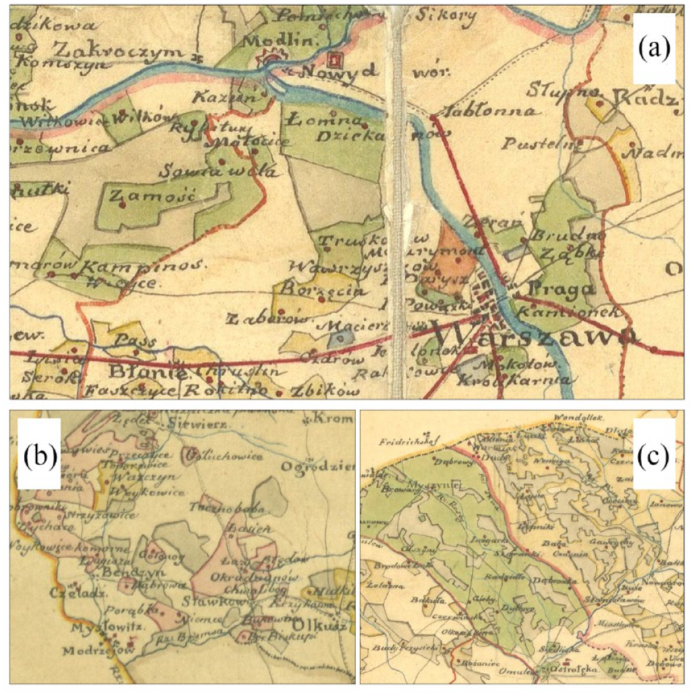
The establishment of the Congress Kingdom in 1815 contributed to the introduction of forest management. The state forests throughout the country were inventoried and divided into different categories according to their use. Pieces of a map of the government forest estate from 1820. (a) Kampinos Forest and its’ surroundings, (b) so-called mining forests in the vincity of Olkusz city in Southern Poland, and (c) Green Forest (Pol. Puszcza Zielona) divided into governmental, national and privative estates.
During the early 19th century, approximately 80% of tree stands in the territory of the Duchy of Warsaw and the Congress Kingdom were dominated by Scots pine (Żabko-Potopowicz, 1965). The so-called plundering forest exploitation also took place in the Vistula basin after the establishment of the Congress Kingdom, dependent on the Russian Empire, in 1815 (Żabko-Potopowicz, 1965). However, it appears that the narrative constructed by earlier forest researchers did not fully correspond to the realities of the time. An example highlighting this issue can be found in the diaries of August von Holsche, a Prussian civil official who documented his work in the newly occupied former Polish territories (Libiszowski, 1960). Holsche pointed out that although many of the Polish forests were severely depleted, he encountered places that impressed him with the quality of the wood material, the state of preservation, or the potential for further exploitation (such as the White Forest, Pol. Puszcza Biała). The successful procurement of high-quality timber and the development of new settlements were closely linked to the progress of future drainage processes planned by the Prussian administration.
An important consequence of the modernization changes of the 18th and 19th centuries was the transformation in energy resource management. Recent research on the history of energy indicates that Central-Eastern Europe (including the Polish territories—Congress Poland and the Austrian Galicia) experienced an intensive period of industrialization during the long 19th century, with a delay of approximately 60 years compared with Western Europe (Malanima, 2020). The delay was directly related to the Second Serfdom in this region, which was abolished in the mid-19th century, leading to the abandonment of feudal elements and a significant transformation in social policy, thereby reinforcing the transition to capitalist economic relations. During the early stages of industrial development (in the 1820s) in Congress Poland, the use of charcoal as fuel (in iron smelting) and wood as fuel for steam engines was prevalent, primarily due to the lack of rich coal deposits on its territories. This reliance on wood and charcoal continued for several years, as the state support of hard coal was insufficient (łukasiewicz, 1963). Wood-fired locomotives constituted a significant portion of the rail transport rolling stock until 1914. It was only at the beginning of the 20th century that the use of coal (fossil fuels) in industry surpassed the energetic use of firewood and charcoal (biomass) (Kander et al., 2013).
The forest cover decreased over the decades. At the beginning of Congress Poland (1815), the forest cover accounted for approximately 30% of the land, but by the beginning of the 20th century, it had declined to about 18.7% (Kowecka and Różycka-Glassowa, 1978). A significant turning point occurred with the outbreak of the January Uprising (1863) against the Russian Empire. Until the outbreak of the January Uprising, the state government had maintained forestry as part of the so-called government property, which included extensive forest areas (Broda, 2007). However, the existing forest management system proved inadequate in meeting the demands of a growing economy (Łukasiewicz, 1977). During the discourse of the 1870s, there arose the idea of using “unusable” peatlands extensively to partially compensate for energy shortages and to reform the existing forest management system (Auleitner, 1879). These developments coincided with a dynamic phase of agricultural development in the Congress Kingdom, which began to flourish in the second half of the 19th century (Strzeszewski, 1934). Subsequent decades saw further interventions in forest policy, primarily through legislation, as efforts were made to address the evolving needs and challenges of forest management.
Kampinos Forest and introduction of forest management
In 1816, the establishment of Kampinos Forest District marked a significant milestone, encompassing more than 14,000 hectares of forest land and maintaining five forest guards (Heymanowski, 1964). This marked the beginning of forest management, which brought about conflicts between the forest officials and the residents of forest settlements. The inhabitants of the forest were perceived by the state apparatus as leading a boisterous lifestyle that contradicted the vision of the modernizing state. They were also seen as perpetrators of forest destruction through illegal tree felling and charcoal burning, actions that were viewed as direct harm to the state. The implementation of forest management necessitated the end of unrestricted utilization of forest products in Kampinos Forest District and other forest complexes (Central Archives of Historical Records in Warsaw, 1819–1844). During the late 18th and 19th centuries, the forest office symbolized the authority and power of the modern state. This was evident through its military characters, such as the uniforms worn by the officials and their possession of weapons. An additional element that reinforced the message of the state’s care of the forest landscape was the use of forest posadas (Pol. posada leśna), that is, specially built (or deliberately occupied) houses for forest officials of different levels in different parts of the KF. It was noted that the implementation of forest management involved the removal of wild bee hives from the area (Heymanowski, 1964).
The emergence and development of forest cartography can be linked to the establishment of the Forest Service, which complemented and was a direct outcome of the development of the Enlightenment model of forestry. In 1816, Plater’s forest inventory law was introduced in the Congress Kingdom, marking a significant step toward the implementation of modern forest management practices (Heymanowski, 1964). These inventories comprised both written and visual components, with maps serving as an integral part—a perfect supplement to the written word. Although only one inventory from 1858 for the Cybulice Holding in the eastern part of KF (in the eastern part of the area) has been preserved (Figure 4), it provides insights into the broader concept of forest management initiated by Ludwik Plater. The map associated with the forest inventory specifically pertains to privately owned forest areas. It effectively illustrates the comprehensive approach to forest management, dating back to the time of Ludwik Plater, where one can find information on the type of a particular tree stand, obligatory management measures, and information on wild animals (here, wolves and foxes). Furthermore, the map also highlights the locations of each administrative forest division (in terms of economy—to which the forest districts and areas of annual logging corresponded) (Figure 4). Remnants of past forest management practices are still visible in KF, evident in the presence of resin-tapped trees (Figure 5).
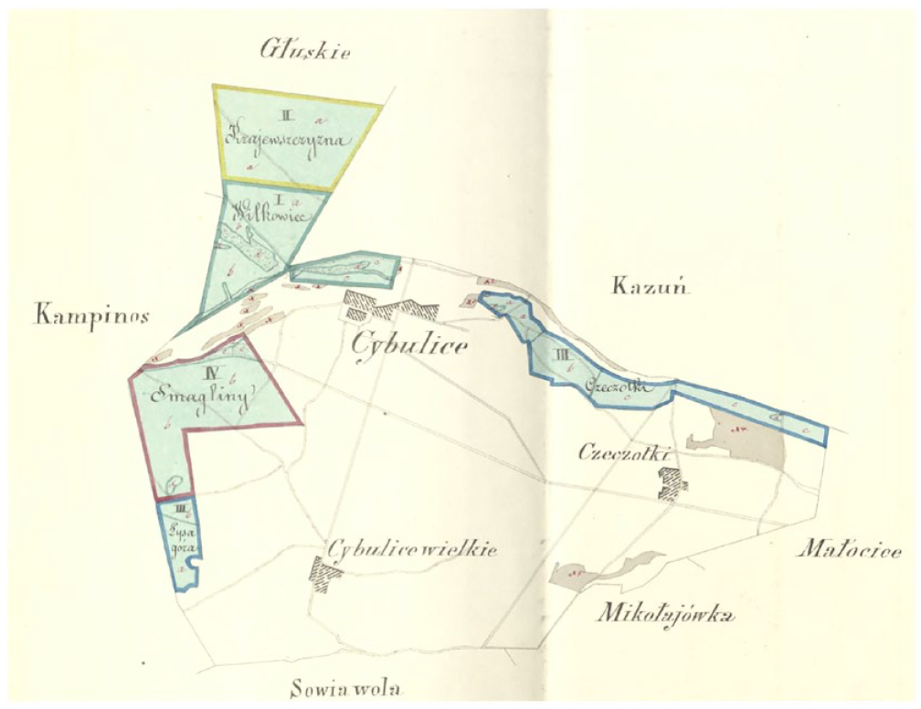
North-Eastern parts of the Kampinos Forest management plan from 1858. The map shows four forest divisions.
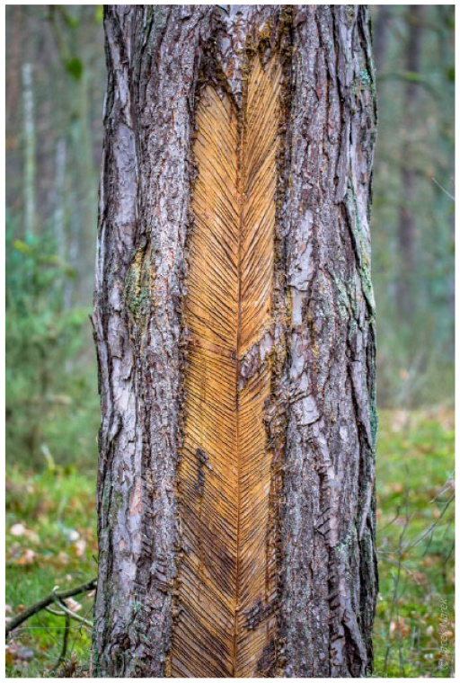
The Kampinos Forest were heavily exploited by forest management in the past. Many relics from this period remain in the landscape of the site. Here we can observe one of the old Scots pine with clear traces of the so-called “Polish method” of resin extraction. Picture taken by Jacek Marek (Kampinos Guiding Collective “ZaPuszczeni”).
The implementation of forest management activities necessitated the establishment of artificial plantings to meet the growing energy needs of the strongly developing Enlightenment countries. Hence, it is well-documented that the genetic material of trees growing in Central Europe originated from various other places governed either by the Prussian state or the Habsburg monarchy. Genetic studies of trees provide valuable insights into the management of gene pools in historically managed forests, including the methods employed to acquire genetic material, organization of work, or distribution of particular genes. By examining surviving written source materials, it may be possible to identify the origin of the genetic material, the procedures for obtaining seeds, and the mechanisms governing the spatial distribution of genetic material (Figure 6). Ongoing studies indicate that certain Polish populations (Wachowiak et al., 2023) are characterized by a common genetic origin and a low number of alien gene forms (alleles) introduced with the development of forest management.
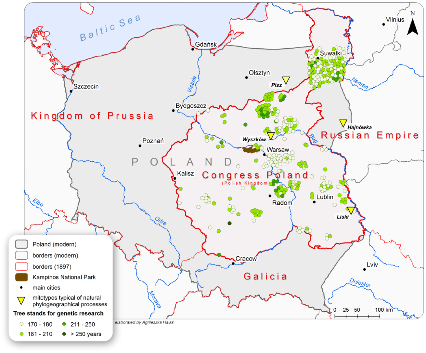
Borders of the 19th century Congress Poland with spatial distribution of the tree stands valuable for future genetic research. Data source: Forest Data Bank (www.bdl.gov.pl, accessed: July 2021), 19th century borders taken from MPIDR and CGG 2012: MPIDR Population History GIS—Rostock spatial database (accessed: 14.02.2023); Kampinos National Park GIS database. Data on mitochondrial DNA haplotypes for Liszki, Hajnówka, Pisz and Wyszków tree stands based on Wachowiak et al. (2023).
As previously mentioned—thanks to the possibility of interdisciplinary research on the KF—we can look at its transformation from many different perspectives. In planning further research, one crucial aspect to consider is tree genetics, particularly in relation to the interruption of the natural selection process of forest trees due to uncontrolled seed trade at the European level. The ecological and economic consequences of uncontrolled seed migration are challenging to estimate and may have either negative or positive implications. The use of seeds of unknown origin and adaptation to local growing conditions is identified as the primary cause of weakened health in selected populations (Noss, 2001). The disruption of tree vitality caused by the import of foreign and untested forest reproductive material was recognized earliest in Sweden. In Poland, there is evidence of the introduction of seeds of foreign and untested origin into native pine stands (Nowakowska, 2007; Prus-Głowacki et al., 1993; Przybylski, 2022). The consequences of introducing foreign genotypes into natural ecosystems are not yet well-described. However, recent studies have confirmed the low breeding quality of trees (Przybylski, 2022). Moreover, stands formed from seeds of foreign origin do not produce an adequate number of seeds for their future continuation. On the other hand, maintaining diversity within species is becoming increasingly important as an “insurance policy” for populations, but it should be emphasized that natural regeneration plays a vital role in the maintenance of in situ populations, provided that these populations are adapted to a changing climate (O’Neill, 2008). Because some gene pools of local trees are likely unable to adapt to dynamically changing climatic conditions, it is often considered that assisted migration of genotypes is required. O’Neill and other authors postulate the need for the translocation of genotypes within the species’ natural range to preserve their plasticity in the face of climate change.
In the current context of dynamic climate change, understanding historical seed migration pathways becomes crucial for assessing alternative responses of tree populations. The persistence or decline of forest ecosystems and species is a pressing concern, and informed forest management requires knowledge of ecosystem diversity at various levels and the historical context in which the studied ecosystems have evolved. As part of a study on the genetic variability of the KNP (Przybylski, 2022), the analysis of progeny provides valuable insights into the history of the oldest populations in Kampinos. The results reveal genetic fragmentation of the forest, highlighting the impact of past forest management practices on the expression of genetic patterns. Currently, we observe the significance of pollen transfer from external sources to the oldest stands, which enriches biodiversity and, on the other hand, decreases the prospects of genetic resource conservation. In light of these results, the need for a multilayered analysis and study of old pine stands is understandable.
In the future, another valuable source for studying human-induced changes in greater detail will be the data obtained from the wetlands of the KF wetlands. So far, preliminary surveys were conducted at the following three KNP sites, namely: Okrąglak, Łuże, and Biała Góra (Figure 7). The hydrological alterations in the area have directly influenced the continuity of accumulation processes and the preservation of organic material. This suggests that Okrąglak reflects ecosystem changes that began at the end of the Late Glacial period. The sediment records at this site demonstrate pronounced shifts in regional vegetation as well as local communities associated with the reservoir itself (in situ). The presence of sediment gaps (hiatus) indicates substantial environmental changes that have occurred over time, that due to sudden and prolonged changes in climate or human activity. Konecka-Betley et al. (1996) already points out that since 5,000 BP, human activity has been increasing and significantly influencing the transformation of Kampinos ecosystems, especially forests. The evidence of human influence is primarily manifested through the presence of different types of pollen and other human indicators, for example, Ceralia sp., Plantago lanceolata or Rumex sp. Additionally, the consistent presence of microcharcoal during this period suggests not only fire activity but also an intensified human influence (Bonk et al., 2022). Landscape modifications attributable to human activity are particularly evident in the Łuże sediment profile. The changes in the ratio of AP (arboreal pollen) to NAP (nonarboreal pollen) clearly indicate deforestation, which correlates with the high content of cultivated and ruderal plants (Latałowa, 1992).
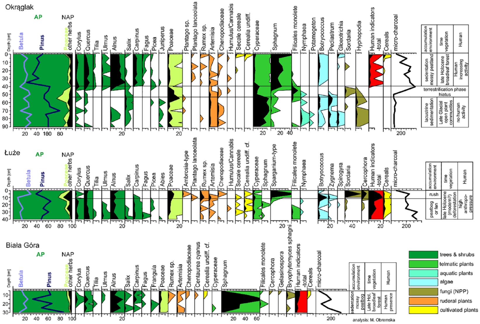
Preliminary results of paleoecological surveys carried out at three sites on the KNF in 2021 presented in percentages pollen diagrams of selected taxa.
The 19th-century wetlands drainage
The water supply in KF primarily relies on atmospheric precipitation and groundwater inflows from outside its boundaries, which is significantly helped by local terrain conditions (Heymanowski, 1964; Kazimierski et al., 2003; Tuszko, 1979). In the preindustrial period, the water level in the Kampinos marshes varied throughout the year, with frequent dry spells during the summer months. These dry periods facilitated internal communication among forest inhabitants and affected the local environment (Figure 8). Until the middle of the 20th century, historical floods of the Vistula River played a role in irrigating the wetlands on the northern and eastern edges of the KF (Heymanowski, 1969b). However, the catastrophic flood of 1947 resulted in significant economic losses and loss of life in nearby areas (Jarosz and Miernik, 2013). As a response, dikes were constructed in subsequent years to protect against future floods. Although these dikes mitigated the penetration of river water into the forest, they also disrupted the natural functioning of the floodplains. The wetlands in KNP present challenges for ecological research, as the central marsh belt has been drained. This drainage has disrupted the accumulation of organic material and accelerated the decomposition of previously accumulated sediments, potentially leading to depositional gaps (hiatus) in the sediment profile. An example of this is the very short record from the Biała Góra site (Figure 7). Historically, almost 90% of the swamps were drained and converted into agricultural land and managed forests.
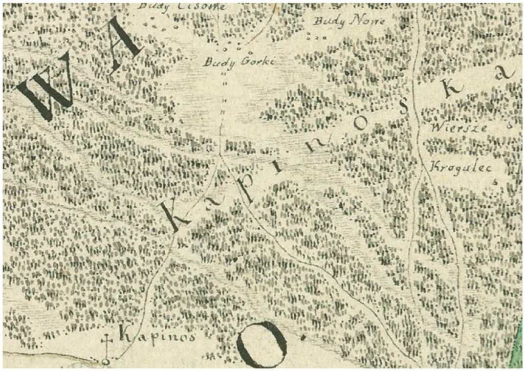
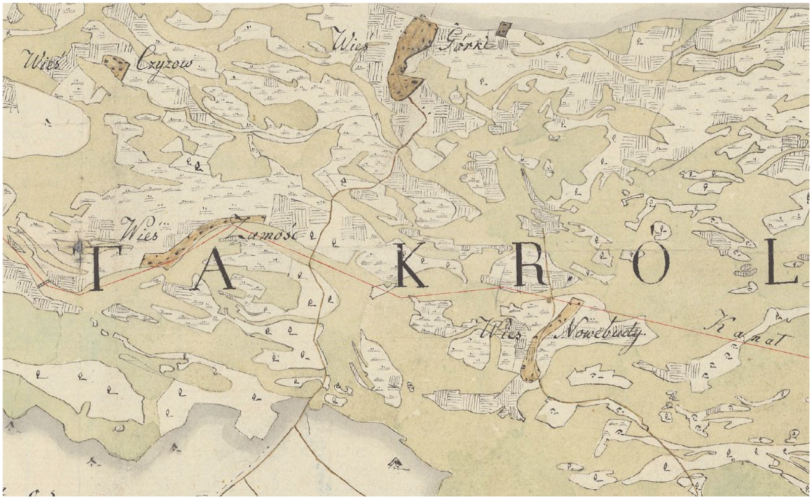
A fragment of Charles Perthées’ late 18th century map showing the centre of KF. The large forest cover of the area and the numerous streams (and wetlands) flowing through the area are shown. At the end of the 18th century, the central meadows strip in Kampinos Forest was not yet so intensively settled. The shading indicates streams and rivers, the solid lines roads.
However, it is important to acknowledge that the very factors that have contributed to the development of water resources in the forest have also had detrimental effects (in the long term). The presence of a single aquifer facilitated the reclamation of the Kampinos. Drainage works in the vicinity of the KF began in the late 18th and 19th centuries in the area of the so-called Łomna Economy (eastern part of the KF) or on the western edge of the forest in the villages of Brzozówka and Famułki Królewskie (Chudzyński, 2005; Heymanowski, 1964). Previous studies on the KF have consistently assumed that systematic land reclamation occurred in the 19th century (Chudzyński, 2005). Most of the cartographical plans preserved until today refer to the planned drainage works and not to the ones actually carried out, since, as Kazimierz Heymanowski noted, the idea of land reclamation in this area had existed for many years (Heymanowski, 1964). Based on the analysis of literature and cartographic materials, it can be inferred that these drainage works were likely conducted between 1861 and 1915 (Figures 9 and 10). It is also noteworthy that disturbances to the water table in the forest area were influenced by forest management practices, including intensive forestry and resource exploitation during World War I (Kazimierski et al., 2003; Zielony, 2004). The land drainage in the southern forest areas also had an impact on the dunes in the north (Kazimierski et al., 2003; Tuszko, 1979). The drainage activities of the northern edges of the KF, which began toward the end of the 18th century but particularly intensified in the 19th and 20th centuries, resulted in significant environmental changes in this forest. The groundwater table decreased, surface water retention was reduced, and the soil moisture decreased, ultimately leading to the disappearance of wetland ecosystems in the long term (Kazimierski et al., 2003; Solon, 2003).
The middle belt of the Kampinos Forest was a very inaccessible place in the early 19th century, inhabited mainly by residents of the forest settlements. The terrain was marshy and only a few places were suitable for growing crops or raising animals. The map of 1821 is the first cartographic attempt to draw up a comprehensive plan for the drainage of the swamps in the middle of the forest. The red line marks the projected channelization.
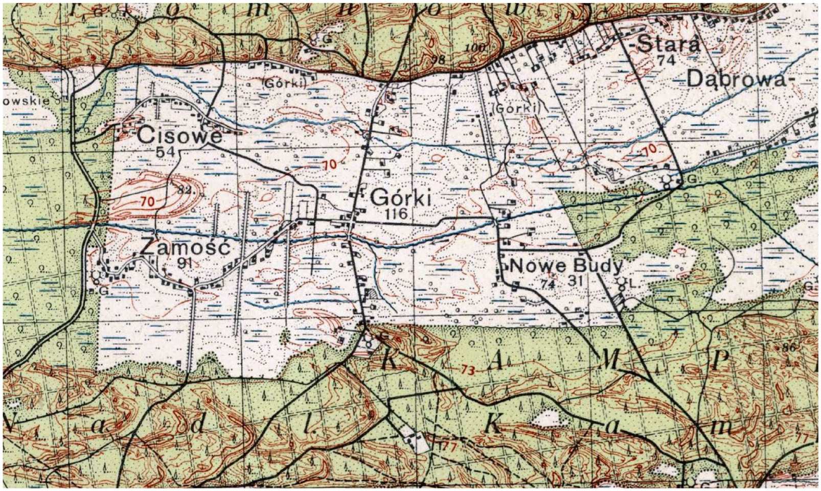
A fragment of the Military Geographical Institute (WIG) map from 1934. A map from the beginning of the 20th century already shows a very advanced degree of anthropogenic formation in the swamp belt of the Kampinos Forest. New settlements, the Łasica Canal and numerous dikes facilitating agricultural work in the drained wetlands are visible. Significant loss of forest cover is also visible.
One possible method for reconstructing and understanding the profound effects of land reclamation processes in the past is dendrochronology. Dendrochronology allows the use of a wide variety of research methods (Ballesteros-Cánovas et al., 2015). Dendroecological studies focus on the relationship between an environmental disturbance (e.g. change in water regime caused by drainage or floods, see Macdonald and Yin, 1999) and the growth response of trees (expressed as a growth depression or release, see Black and Abrams, 2003, 2004), the subsequent return to the predisturbance growth pattern (Aakala et al., 2011), and changes in wood anatomical structure (Astrade and Bégin, 1997; Ballesteros et al., 2010). Analyzing specific proxies of disturbance is essential for understanding the impact of disturbances on forest ecosystems (Bräuning et al., 2016). These proxies include reaction wood formed in response to mechanical stress (Holeksa et al., 2016), fire scars (McBride, 1983), resin ducts (Hood et al., 2015) formed under the influence of high temperatures during forest fires, resin harvest-induced scars (Choi et al., 2020), flood scars (Gottesfeld, 1996; Gottesfeld and Johnson Gottesfeld, 1990), and tracheid and vessel dimensions (e.g. “shrunken vessels,” see St. George and Nielsen, 2003). In addition to disturbance proxies recorded in tree rings, other natural archives can also provide valuable insights into past disturbances in forest ecosystems (Kuosmanen et al., 2020). However, there is still a scarcity of studies that employ different disturbance proxies to reconstruct forest management history (Lindbladh et al., 2007).
Dendrochronological studies in the KNP area have not yet been conducted. Hence, we are fully aware of their pioneering nature. Here, dendrochronology offers a valuable approach to reconstructing environmental changes (including alterations in local hydrology caused by drainage activities during the 19th century) over the past 200 years with annual or even seasonal resolution (Potapov et al., 2019). The availability of study sites with tree ring records spanning the past 200 years is limited to areas that have experienced little to no management during the 20th century, typically classified as strictly or partially protected sites. By utilizing high-resolution (inter- and intra-annual) and continuous tree ring data for the past two centuries, coupled with paleoecological records, we can engage in discussions about large-scale, human-induced environmental changes in the KF as evidenced by written sources. In the dating and reconstruction of environmental changes, it is essential to incorporate tree-ring and wood anatomy proxies, and in particular, these proxies can provide valuable insights into flood and fire events and drainage activities. Temporal variations in growth trends, growth depression, and ring-width fluctuations can offer valuable information about tree growth response to environmental disturbances (Dang and Lieffers, 1989).
Furthermore, it is worth mentioning that biogenic sediments from KNP wetlands can provide very valuable information on the question of changes in water conditions in the past. This information can be provided by testate amoebae analysis (Mitchell et al., 2008). Testate amoebae (Protist) are single-celled microorganisms living in soil, wetlands, and freshwaters. They are highly sensitive to water availability and are successfully used for the reconstruction of peatland water table depths (Amesbury et al., 2018; Booth, 2001). The hydrological conditions in peatlands can be influenced by climate patterns as well as human activities; therefore, the changes in the community of testate amoebae over the centuries, when combined with other proxies such as pollen, dendrochronology, and plant macrofossils, can provide evidence of climate changes, land use changes, and drainage of peatland (Swindles et al., 2019; Łuców et al., 2020). In particular, in the context of KF, it is particularly important to trace local hydrology based on testate amoebae analysis and examine changes in local hydrology resulting from drainage activities during the 19th century. These analyses can be complemented by the use of ecohydrological modeling, which takes into account completed and planned drainage plans in the study area. Ecohydrological modeling would allow us to determine the water balance changes that occurred as a result of the existing environmental modifications and predict potential changes that could occur if all the drainage plans were implemented.
The military landscape
It is well-known that military conflicts have a significant impact on environmental resources (Laakkonen and Tucker, 2012; McNeill, 2004), and war, by its very nature, is resource-intensive and often results in the overexploitation of local resources (Tucker, 2012). At the beginning of the 19th century, construction began on the largest fortress in Polish lands on the border of the KF (in the village of Modlin). Until 1915, this fortress served as a vital military facility in the Russian-controlled Kingdom of Poland. The fortress occupied an area of 55 hectares, but the area of its influence was much larger due to the felling of trees and the leveling of the terrain for the free field of fire of the fortress artillery. On the other side of the Vistula River, already within the KF, a part of the fortress was built in the village of Kazuń to guard the river crossing (Figure 11).
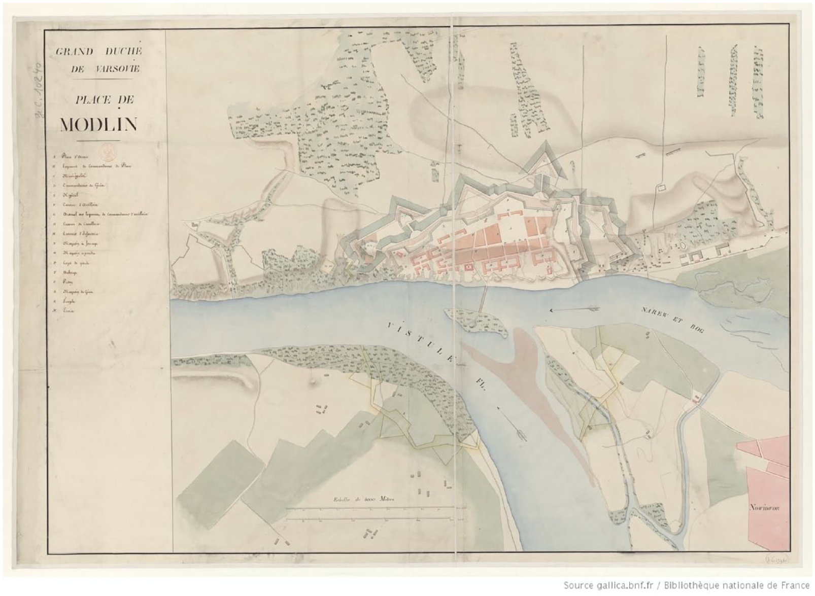
Plan of the Modlin Fortress and the Kazuń foreland in the times of the Duchy of Warsaw.
During the 1830s, the tsarist authorities initiated the expansion of the fortress, leading to the replacement of its fortifications with masonry. This decision significantly increased the demand for timber for construction purposes. In 1832 alone, more than 2 million bricks were purchased, and more than 5000 workers were employed for construction. This included the foundation of huge barracks that could accommodate several thousand soldiers (Oleńczak, 2009). It is estimated that the construction of the fortress barracks required the use of more than 54 million bricks. Additionally, a substantial quantity of building materials, including at least 150 million bricks, was required for the construction of the fortress’ fortifications. Local brickworks supplied these building materials (Oleńczak, 2009). The construction activities and the need for firewood also necessitated the utilization of surrounding forests, including the KF. Between 1883 and 1915, a total of 29 forts were erected around Modlin, arranged in two defensive rings (Oleńczak, 2009). Notably, five of these forts were constructed directly inside the KF, leading to further disruption of the local ecosystem.
The KF served as a crucial resource base for the tsarist army stationed in Modlin. The Russian planners recognized its significance in meeting their fuel and building material needs, which were undoubtedly substantial. In 1841, the fortress had a minimum garrison of 8000 soldiers, and when considering family members and the civilian population, several thousand individuals resided in the vicinity (Fuglewicz, 2006). Put this into perspective, the population of Lublin, the country’s second-largest city, was comparable at that time, with approximately 13,500 inhabitants (Rodecki, 1830). The utilitarian approach to the environment was reinforced by the Russian legislation, when, according to the Russian Fortress Acts, the commander of the Modlin Fortress, in the event of war, gained full power of disposal over all resources in a radius of about 30 km around the fortress. In practice, this meant that the entire KF was under strict military control (Figure 12).
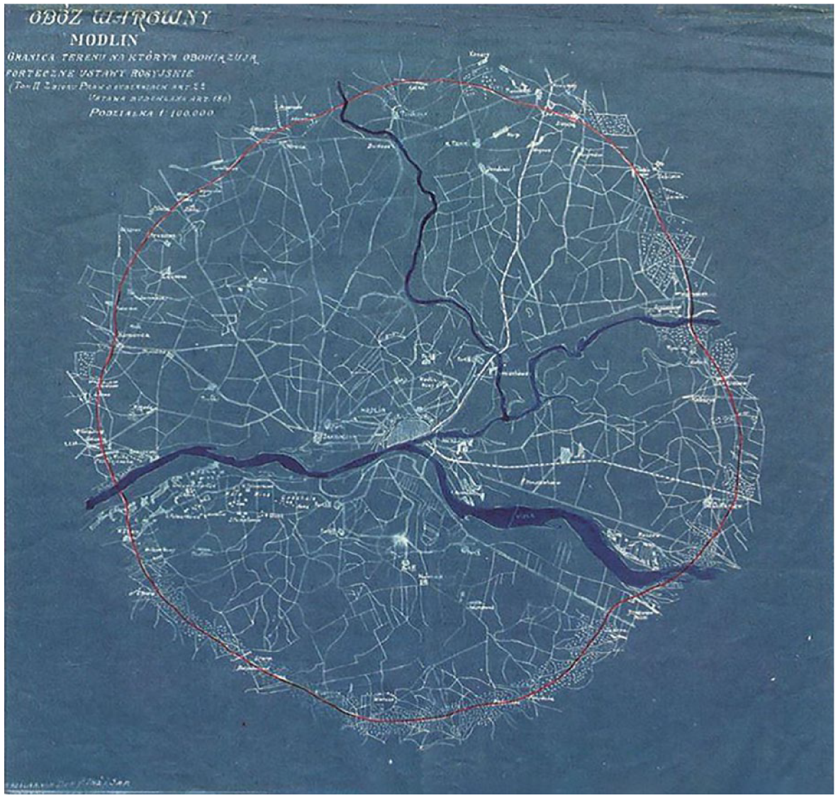
Modlin military area subjected to inspection by the commander of the Modlin garrison.
Research perspectives on past forest landscapes during the Anthropocene
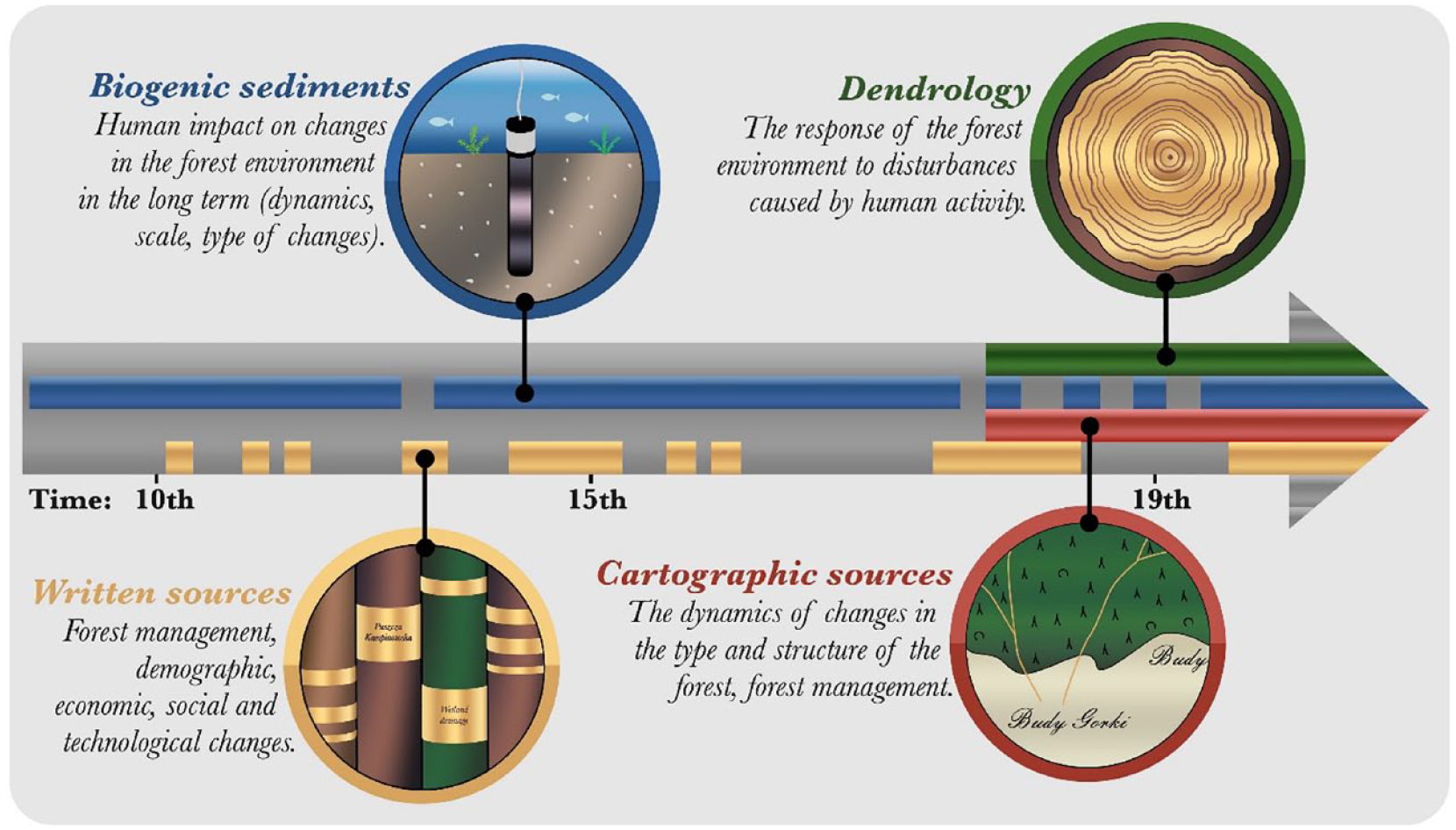
In this article, our aim has been to demonstrate that a comprehensive understanding of the changes in the ancient environment, shaped by human activities, can only be achieved through the integration of various disciplines. We wanted to make it clear that in the case of the changes in the late 18th and early 19th centuries, the essential concept for bringing together the different disciplines (history, cartography, spatial analysis, tree genetics, paleoecology, dendrochronology, and forest sciences) is the common denominator—modernization, which manifested itself not only in social, economic, and energetic but also (or especially) in ecological changes. What naturally appears to be an advantage of this approach is also its limitation, of which one should be aware. Despite these challenges, this integrated approach provides a more comprehensive understanding of the complex interplay between human activities and the environment (Figure 13).
A skilled combination of data from written archives together with nature’s archives will allow us to build a comprehensive reconstruction of past environmental change, and a better understanding of human activity in the past.
The long-term changes that have occurred in the KF can be examined from various perspectives. From a landscape-ecological standpoint, the most significant changes lie in the composition and configuration of land cover or vegetation as described in phytosociological terms. These changes can be attributed to multiple factors that have acted simultaneously to shape the spatial structure of the vegetation landscape. Briefly, these factors can be categorized as follows: (a) habitat changes, (b) changes in land cover and land use, and (c) natural and/or human-induced developmental processes affecting the existing vegetation. In the area studied, all three groups of factors play an important role. Among the habitat changes are several, partially independent, schemes: (1) natural changes in the Vistula valley as a result of changes in the river bed and riverine sediment deposition—as are exemplified by changes in an area of Salici-Populetum and Ficario-Ulmetum habitats; (2) human changes connected with drainage, land reclamation, and constructions, particularly not only on the swampy belts but also on the Vistula River terraces, leading inter alia to a reduced area of hydrogenic habitats; and (3) the natural and half-natural evolution and aging of habitats due to erosion, organic matter allocation, soil forming processes, and so on. Changes in land use and land cover can be attributed to external factors that have influenced the vegetation. These factors include profound shifts in the method of ecosystem exploitation and the spatial organization of the landscape, which have arisen from new socioeconomic conditions.
The process of modernizing the management of forest and water resources led to simultaneous changes of contrasting directions and nature. On one hand, there was a decrease in the contrasts of water relations (disappearance of vast marshy areas and simultaneous increase in water content in driest soils—the latter due to an increase of their water capacity, not irrigation). On the other hand, there was an increase in the contrasts of current vegetation, both in the aspect of communities treated as landscape elements and vegetation landscape as a whole. The increase in contrasts stemmed from the persistence of patches of communities with multi-layered, complicated structures and well-developed natural regulating mechanisms (homeostatic), as well as the development of communities with simplified flora composition, regulated mainly by anthropogenic mechanisms (Solon, 2003).
Finally, it is important to acknowledge that environmental changes in the past (not only in forest areas) have influenced the development of attitudes toward the relationship between humans and the environment. These attitudes can be categorized into three fundamental processes:
Transformation: This period denotes rapid and revolutionary changes in landscape composition, often accompanied by a shift in the primary function of the landscape and affecting mainly the landscape composition.
Adjustment: This period is characterized by the development and stabilization of a new pattern of dynamic equilibrium between habitat conditions, the goals and modes of human management, and the spatial distribution and functioning of ecosystems (changes affecting mainly landscape configuration).
Fluctuation and/or evolution: This period comprises small non-directional changes or small cumulative changes resulting in landscape change in the long term (mainly changes in species composition due to degeneration/regeneration processes within permanently persistent vegetation/land cover types, with minimal alterations in the extent of individual types).
Considering these contexts, alongside modernization studies and interdisciplinary methods, provides a solid foundation for further elucidating environmental changes due to human activities in the past.
Footnotes
Acknowledgements
We would like to thank Agnieszka Halaś for preparation of Figure 6, and Dariusz Brykała for the mental support in writing this article. We are also grateful to the reviewers whose comments have allowed us to improve the article.
Funding
The author(s) disclosed receipt of the following financial support for the research, authorship, and/or publication of this article: TZ and MO founded their research from National Science Centre (NCN) grant, “Bishops’ trees: the environmental history of the White Forest” (No. 2021/43/B/HS3/02636). TZ, DŁ, EP, PS, MK, PP, EZ, KP funded their research from the project by NCN called “Anthropogenic transformations of the environment in the context of modernization processes of the Congress Poland” (No. 2022/47/D/HS3/02947). JP founded his research from the NCN grant, “Entangled in common rights. The impact of conflicts over common rights and common lands on socio-economic changes in Western Galicia in the second half of the 19th century” (No. 2020/39/D/HS3/01298). MS and KS founded their research from the NCN grant, “Impact of charcoal production on environmental changes in Northern Poland – a novel ‘multi-proxy’ approach” (No. 2018/31/B/ST10/02498).