
Abstract
Road development in tropical forest landscapes is contentious. Local preferences are often subordinated to global economic and environmental concerns. Opportunities to seek solutions based on local context are rare. We examined local perspectives on road development within Cambodia’s Keo Seima Wildlife Sanctuary to explore opportunities for optimizing conservation and development outcomes. We conducted household surveys to document the perceived benefits and risks of road development. We found that in the sanctuary, road rehabilitation may accelerate transitions to intensified agriculture and diversified, off-farm incomes. All households prefer good roads and poorer households prioritize road development over other village infrastructure. Households perceive the most prominent benefit of roads to be access to hospital. Local government authorities are responsible for controlling land use and conversion within village boundaries and are therefore highly influential in determining the social and environmental outcomes of roads. Strategies to mitigate environmental risks of roads without constraining development benefits must focus on improving local capacity for decision-making and transparency. Local institutions in tropical forest landscapes must have greater control over development benefits if they are to reinvest assets to achieve conservation success.
Keywords
Introduction
Reconciling the trade-offs between negative environmental impacts and societal benefits of roads is inherently challenging. In tropical developing countries, roads can increase the effectiveness of agricultural extension services and adoption of improved agricultural technology, increase school enrolment, increase market access by lowering transportation costs, and shift households from agriculture to service-based employment (Aggarwal, 2018; Khandker, Bakht, & Koolwal, 2009; Mu & Van de Walle, 2011; Rammelt & Leung, 2017). Roads also disturb tropical forest ecosystems (Laurance, 2015; Laurance, Goosem, & Laurance, 2009; Laurance, Sloan, Weng, & Sayer, 2015; Trombulak & Frissell, 2000). The correlation between road density and deforestation is well documented across the global tropics (Angelsen & Kaimowitz, 1999; Barber, Cochrane, Souza, & Laurance, 2014; Geist & Lambin, 2001). Less is known about the complex social, economic, and political aspects of road development at the landscape scale, especially from the perspective of remote forest communities (Alamgir et al., 2017; G. R. Clements et al., 2018).
Conservation is increasingly recognizing the importance of understanding local perceptions, preferences, and priorities for sound environmental management (Bennett, 2016). Yet rural people are rarely consulted when identifying potential gains and risks of roads through tropical forests (G. R. Clements et al., 2018). Road development is often part of political agendas to achieve economic growth (Fernández-Llamazares et al., 2018; Laurance, 2018; Sloan et al., 2018). Roads can provide access to markets and health and education services, opportunities for information exchange, and enabling conditions for the provision of electricity and water services (Hettige, 2006; Jacoby, 2000). Yet evaluations of rural road projects often lack rigorous or transparent empirical impact assessment. Unjustified assumptions over local impacts are frequent (Van de Walle, 2009). Recently, scholars have drawn attention to hidden socioeconomic and political risks of roads and the impacts of roads on Indigenous people in the tropics (Alamgir et al., 2017; G. R. Clements et al., 2018; Laurance, 2018; Sloan, Campbell, Alamgir, Engert, et al., 2019). Benefits of road development may be unevenly distributed and can lead to increased competition for labor and exacerbate wealth inequalities between rural households (Jacoby, 2000; Rammelt & Leung, 2017).
Identifying benefits and risks of roads before their development gains momentum is important to make spatial and temporal trade-offs explicit (Conde et al., 2007; Laurance & Arrea, 2017). As roads improve accessibility, they enable access to technology for improving livelihoods (Jouanjean, 2013). Combined with environmental protection policies, the transition from low productivity livelihood systems into more prosperous livelihoods can facilitate long-term conservation benefits (Muller & Zeller, 2002; Munroeaic, Southworth, & Tucker, 2002). In Ghana, Acheampong, Sayer, and Macgregor (2018) found that road improvement enhances smallholder productivity and thereby reduces forest encroachment. In India, Kaczan (2017) found road construction contributed to tree cover expansion, indicating the role of rural roads in facilitating reforestation. Over a longer timespan and with appropriate policies, roads can provide the impetus for rural communities to move out of poverty—the standard rationale for road development (Jouanjean, 2013). Societies may then reinvest remnant in forest conservation after initial deforestation or reduce pressure on forests via urbanization (Ehrhardt‐Martinez, Crenshaw, & Jenkins, 2002; Mather, Needle, & Fairbairn, 1999).
The increase in the number of infrastructure projects in tropical countries driven substantially by the China-led Belt and Road Initiative requires a concomitant increase in targeted, evidence-based, holistic, contextual research on road development (Ascensão et al., 2018; Lechner, Chan, & Campos-Arceiz, 2018). Countries that may have the most to gain from improved infrastructure are also at risk of substantial harm to natural ecosystems (Balmford et al., 2016; Laurance et al., 2014). Compromise solutions of environmentally viable road development such as the re-routing of new roads to maximize socio-economic returns and minimize ecological costs are rare (Caro, Dobson, Marshall, & Peres, 2014; Hopcraft, Bigurube, Lembeli, & Borner, 2015). Top-down, external pressure requiring governments to restrict road building through forests is unlikely to resolve issues in areas that do not receive international attention (Caro et al., 2014). Solutions will be easier to find if they are inspired by the people living in and governing tropical forest landscapes, in line with principles of sustainability science (Clark & Dickson, 2003). That means problems must be framed collaboratively (Brondizio, 2017), relevant to locally contextualized development problems, with the inclusion of local decision makers. Solutions must be perceived as credible both within and outside the scientific community (Langston et al., 2019; Wall, McNie, & Garfin, 2017). Through partnerships and stakeholder forums, scientists have the opportunity to influence decisions that improve sustainability, as well as learn from their implementation. Empirical learning and technological innovations can help reduce the cost of infrastructure development in tropical countries and environmental impacts (Clevenger & Waltho, 2005; Schweikert, Chinowsky, Espinet, & Tarbert, 2014; Van Der Ree, Smith, & Grilo, 2015).
In this article, we examine landscape-level decision-making systems concerning road development in Cambodia. Cambodia exemplifies tensions between conservation and development and the urgent need for holistic research. More than half of the country’s 6,000 km of roads are of poor or bad quality and remote villages often do not have all-season access to basic needs (Ministry of Public Works and Transport, 2018). Yet roads are one of the largest threats to forest ecosystem integrity and conservation efforts (Lacerda, Schmitt, Cutter, & Meas, 2004). Focusing on Keo Seima Wildlife Sanctuary in Mondulkiri province, we explore the process of road development and improvement when roads are desired by local Indigenous communities but where environmental risks are high. We build on previous work that identifies roads as a major driver of deforestation in the area (Evans, Bauran, & Delattre, 2009) and explore how local communities perceive and prioritize road development. We suggest how local institutions and development strategies might mitigate the environmental impacts of roads. Our case study demonstrates the value of local perceptions in framing and identifying opportunities for strategic road development.
Road Development in Cambodia
The Kingdom of Cambodia lies within the Indo-Burma biodiversity Hotspot, one of the world’s most important and threatened biological regions (Myers, Mittermeier, Mittermeier, Da Fonseca, & Kent, 2000; Sloan, Jenkins, Joppa, Gaveau, & Laurance, 2014). Despite a growing urban industrialized economy, almost 80% of Cambodians live in rural areas (World Bank, 2019). Forest area is declining at a rate of 1.2% annually and has decreased from 71% to 52% of the national territorial extent over 1990–2015 (Food and Agriculture Organization, 2015). High deforestation, poor governance, and high rural migration places Cambodia on the initial stages of the forest transition curve (Mather, 1992), with no indication of conditions changing (Riggs, Langston, & Sayer, 2018; Scheidel & Work, 2018). Government policies prescribe a balance between conservation and development, but in reality, political interests favor economic growth (Beauchamp, Clements, & Milner-Gulland, 2018).
Cambodia’s economic policies strategically align with China’s Belt and Road Initiative, which seeks to connect and integrate Asia with Europe and Africa through infrastructure and investment (Chheang, 2017). Investment in transport infrastructure is spreading further into remote areas of Cambodia, giving rise to concerns about the social and environmental consequences (Balmford et al., 2016; Mahanty & Milne, 2015; Sokphea, 2017). As is common in other countries, rural road construction in Cambodia is often the responsibility of local government authorities that do not have sufficient funds and resources to carry out Environmental Impact Assessments (EIAs) or allocate funding towards mitigation strategies and road maintenance (Alamgir, Sloan, Campbell, Engert, & Laurance, 2019; Crist, Kauppila, Vassallo, & Wlaschin, 2013). Even when mandated by law, EIAs are broadly considered superficial and inadequate in many aspects (Schulte & Stetser, 2014). In protected areas, conservation authorities must work within local governance systems to balance social, economic, and environmental objectives.
Case Study: Keo Seima Wildlife Sanctuary
Keo Seima Wildlife Sanctuary is located at the southern perimeter of Mondulkiri province, bordering Vietnam. Previously demarcated as the Samling Industrial Logging Concession, the area was designated a biodiversity conservation area in 2002 and declared as Seima Protection Forest in 2009 under the Ministry of Agriculture, Fisheries, and Forestry (MAFF). The 292,690 ha Protected Area (PA) became Keo Seima Wildlife Sanctuary (KSWS) when the Ministry of Environment (MoE) became responsible for all protected areas in Cambodia in 2016. The PA is managed by the MoE with technical support from the Wildlife Conservation Society (WCS) and recently became the site of one of Cambodia’s first active REDD+ projects, comprising of a 166,983 ha core protection zone (Evans, 2013). The KSWS species checklist records a total of 959 species, including plants, animals, and fungi (Griffin, 2019). A total of 75 species are listed as critically endangered, endangered, or vulnerable on the International Union for the Conservation of Nature’s Red List of Threatened Species, including the world’s largest known population of Black-Shanked Douc langur (Pygathrix nigripes), regionally important populations of Gaur (Bos gaurus), and globally important populations of Green Peafowl (Pavo muticus). Threatened flora include several species within the Fabaceae and Dipterocarpaceae families.
As a frontier area, KSWS is subject to high rates of in-migration, forest clearance by smallholders, hunting for the illegal wildlife trade, and logging for high value timber.
Villages mostly consist of Indigenous Bunong communities, with a growing Khmer population. The 2008 Protected Area Law requires protected areas to be divided into four management zones: core zone, conservation zone, sustainable use zone, and community zone. Villages can exist within the community zone and access resources within the community, sustainable use, and conservation zones. Many of the protected areas in Cambodia, especially those recently coming under the management of the MoE such as KSWS, are not yet legally zoned, although the zonation process is currently under way in KSWS. Villages located inside KSWS therefore currently have a mix of official and unofficial boundary agreements with the MoE. Officially recognized boundaries and title include the Indigenous communities living in KSWS that have received Indigenous Communal Title (ICT), which recognizes their land ownership based on traditional and historical use for residential land, agriculture, forest protection, spirit and burial forest, and future conversion. 1 Mapping village boundaries and providing support to ICT villages is a core part of the KSWS management strategy, clarifying which forest areas inside the KSWS border can be reserved for community use and which areas are part of the wildlife sanctuary.
In the early 2000s, the construction of National Road 76 transformed the landscape. The road extends across KSWS and the recently dissolved Snoul Wildlife Sanctuary, connecting Mondulkiri with provinces closer to the national capital Phnom Penh. The road catalyzed forest conversion (G. R. Clements et al., 2014) and facilitated trade between Vietnam and local villages. By 2013, almost all of Snoul Wildlife Sanctuary had been cleared of natural evergreen forest for agriculture and settlement, providing rationale for its degazettement in 2018 (Figure 1). Improved accessibility has enabled the provision of infrastructure, including electricity, and supported the shift from subsistence to cash crop farming, and in some cases into services and trade (Hak, McAndrew, & Neef, 2018). Yet the majority of local roads to remote villages are still in poor condition, with some impassable during the rainy season.
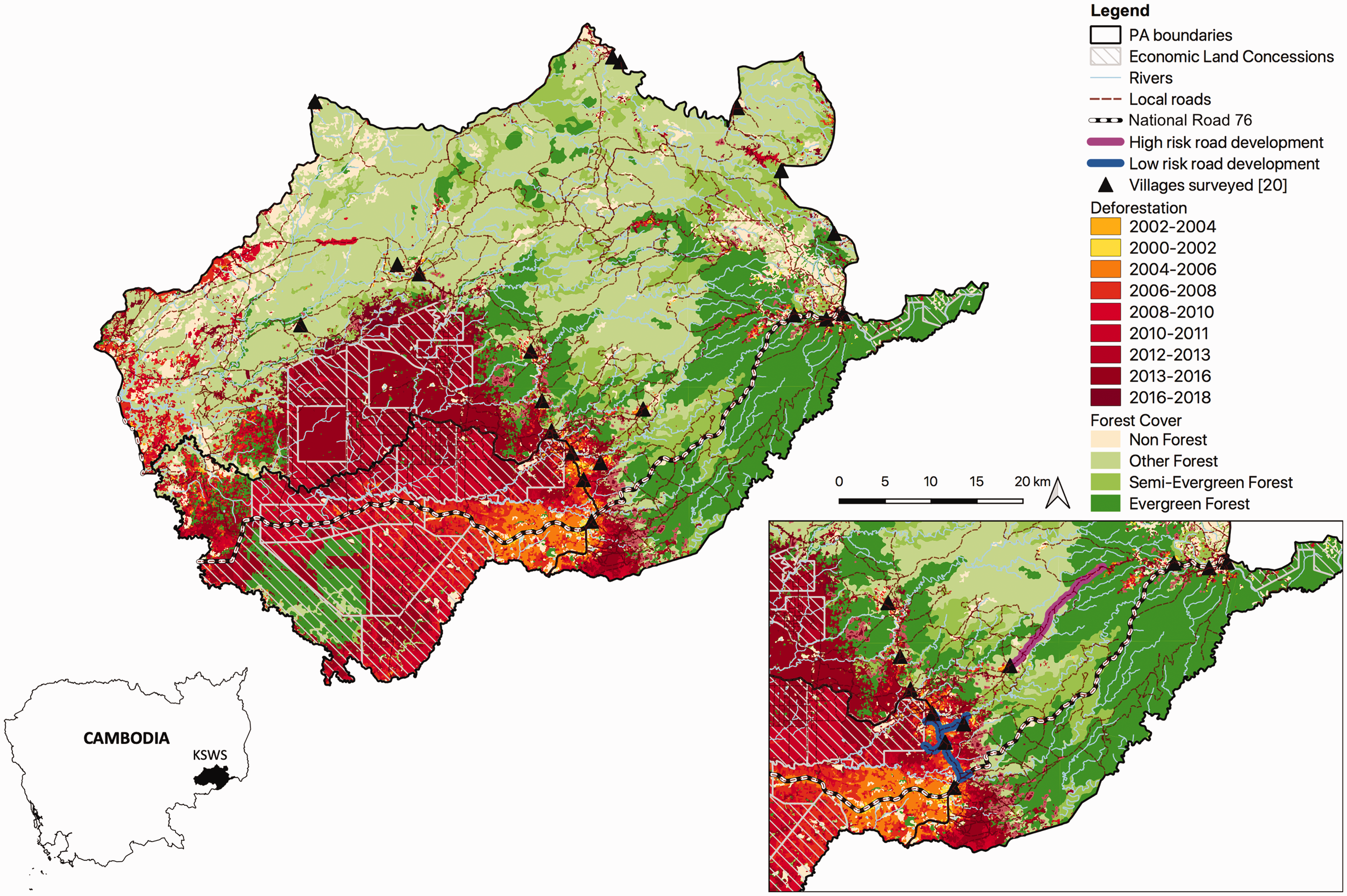
Keo Seima Wildlife Sanctuary and Snoul Wildlife Sanctuary showing deforestation from 2000 to 2017 and location of National Road 76. Land cover data were obtained from WCS’s spatial data set. Insert shows KfW road rehabilitation and risk assessment. Villages shown are the 20 included in the household survey.
Local commune authorities have limited budgets and cannot fulfill road maintenance investment requirements of all villages. The German Development Bank (KfW), in cooperation with the Ministry of Rural Development, recently rehabilitated four roads inside KSWS, totaling 16 km in length. The initial proposal in 2015 included the rehabilitation of five roads in the core zone of KSWS. In consultation with conservation authorities, KfW assessed one road (highlighted in Figure 1) as conflicting with KfW sustainability principles and eliminated it from the program. The rehabilitation of four other roads on the border of KSWS, considered to be of lower environmental risk, was completed in 2017. Other road projects in the area include the recent construction of a road through a rubber concession bordering KSWS in 2016, ongoing road rehabilitation funded by commune authorities, and small-scale road maintenance with REDD+ funding. In addition, a new road is being built along the border of Vietnam for national security purposes, connecting to National Road 76 and cutting through intact evergreen forest within KSWS.
Methods
We selected Keo Seima Wildlife Sanctuary as the study site due to the long-term engagement by WCS in the landscape and emerging issues concerning roads and conservation and development trade-offs. Recognizing roads as a persistent issue for conservation of KSWS and given the existing depth of knowledge of environmental risks, we sought to better understand how local people living in the landscape perceived road development. We attempted to answer the following questions, by interviewing people in, and surveying, 20 villages within and around KSWS:
What are the perceived benefits and risks posed by road development? Do remote communities prefer to remain isolated, or do they prefer increased accessibility? Is road development a priority for village infrastructure? If so, why?
In 2017, we completed a household survey within the 20 villages. The household survey was part of the Social Impact Assessment (SIA) for the REDD+ project in KSWS. Survey design was guided by previous household surveys conducted in KSWS (Evans, 2007; Travers, Winney, Clements, Evans, & Milner-Gulland, 2015) and was piloted in a village bordering the study site prior to data collection. Households were randomly selected, and interviews took place with the household head when possible, with verbal consent. Interviews were conducted independently by an experienced team of Cambodian surveyors contracted by WCS to avoid biased responses. The survey gathered information on social and economic conditions of the households, land ownership, agricultural expansion, and perceptions on governance, environmental values, and roads (see Supplementary Materials for questionnaire). Respondents were also asked about forest-related activities, such as collecting nontimber forest products and logging, with a specific focus on resin tapping—the dominant forest-based livelihood in the area (Evans, Piseth, Phaktra, & Mary, 2003). In the questions regarding road development, we distinguished between good roads and bad roads to differentiate between the existing roads in very poor condition and roads that are easier to traverse. In KSWS, good roads are typically wider, accessible year round, and surfaced with compacted laterite. Roads in bad condition are subject to flooding, often impassable during the wet season and in some cases too narrow for four-wheel vehicles, necessitating use of motorbikes with wheel chains (Figure 2).
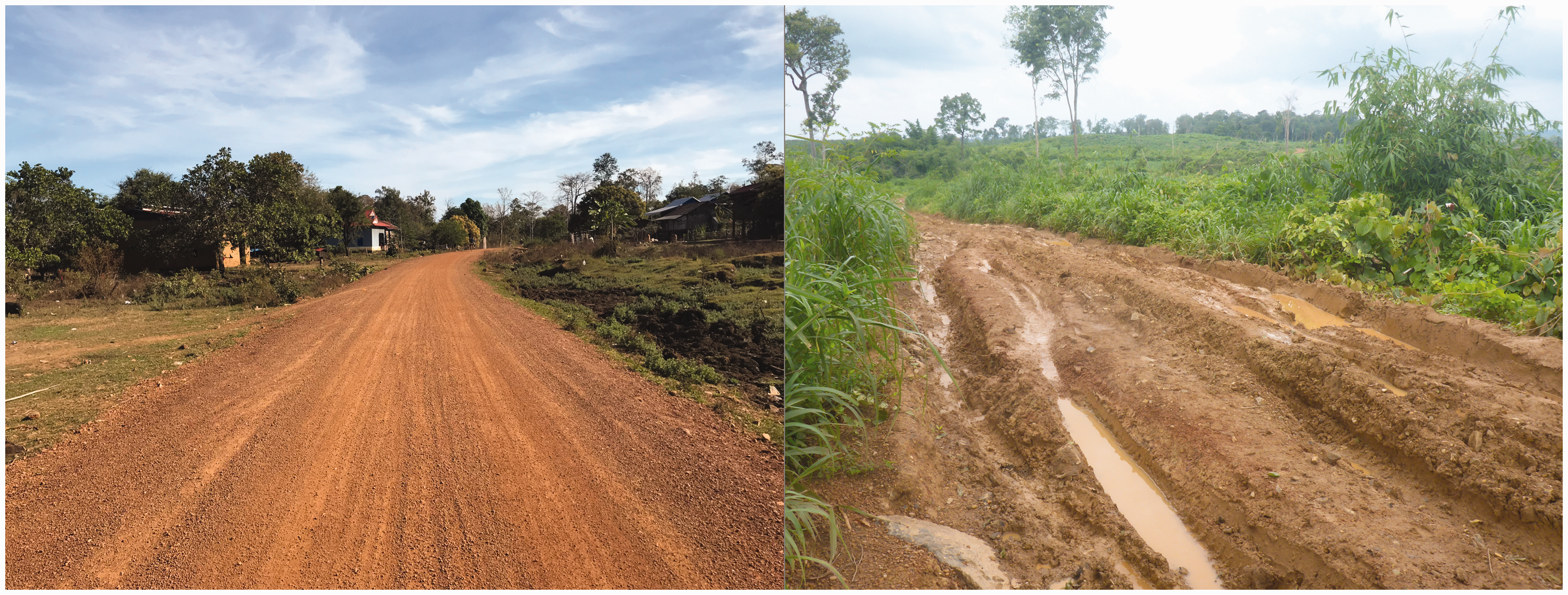
Examples of roads in Keo Seima Wildlife Sanctuary in good (left) and bad (right) condition.
As village population sizes were not known, we sampled a minimum of 30 households per village, resulting in 620 responses overall. To complement the survey, we also conducted key informant interviews in three villages, each with a different level of accessibility (low, medium, high). Interviews were conducted independently of the conservation agencies by the first and second authors with a translator. We consulted with the village chief to select our initial key informants, then followed a process of snowball sampling in which individuals were recommended by interviewees. Key informants were selected to represent the diversity of households in the village with respect to age, ethnicity, income source, wealth, length of local residency, and local social status, until a saturation point was reached (Newing, 2010). We also interviewed local authorities, provincial government departments, and PA managers to build an understanding of decision-making relevant to road development (Table 1). Additional information was gathered through informal discussions with villagers and nongovernment organizations (NGOs) active in the landscape.
Sources of Information.

In the household survey, questions addressing perceptions of roads were open-ended, allowing respondents to use their own words and level of detail. On completion of the survey, open-ended responses were coded by theme regarding benefits and risks of roads. For responses that fit more than one theme, multiple codes were assigned to the response. Frequency of themes across all respondents was calculated using NVivo V12.2.0.
The household survey involved a priority setting exercise that required respondents to rank village infrastructure types by perceived importance. Five infrastructure types were available for ranking: community buildings, sanitary toilets, domestic water supply, road improvement, and electricity. We then asked respondents to explain their choice of highest ranked infrastructure. Statistical analysis was used to explore the relationship between households’ choice of most important infrastructure and their socioeconomic characteristics. The purpose of this step was to better understand the characteristics of the households that prioritized road development. With this knowledge, efforts to mitigate environmental impacts of roads might better target and complement the livelihood strategies of those living in the protected area (Bennett, 2016; Cinner & Pollnac, 2004).
Households were categorized into a binary response variable differentiating households that prioritized roads over other infrastructure types (n = 255) from all other households (n = 355):

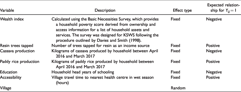
All household socioeconomic predictor variables gathered from the survey were individually tested against this response variable to determine the statistical significance of its association. For continuous predictor variables, a two-sampled t test was performed, while the Wilcox rank-sum test was performed if the normality assumption was violated. For categorical predictor variables, we used Pearson’s chi-squared test. Subsequently, using only those predictor variables with bivariate significant associations of p < .05 (Table 2), we performed a logistic regression to describe the multivariate relationship between the response and these predictor variables. A mixed-effects model was selected to account for the correlations between household data within a single village (Soe & Yeo-Chang, 2019; Wu, 2009). The mixed effects logistic regression was a random-intercept model using Yij as the response variable. The predictor variables were treated as fixed effects while the respondent’s village was incorporated as a random effect (Table 2).
Variables Used in Logistic Regression with Significant Association to the Response Variable of Roads Ranked as First Priority for Infrastructure.
Results of the Fixed Effects in Logistic Regression Predicting Likelihood of Household Ranking Roads as First Priority for Infrastructure in Village.

SE = standard error; p = significance; odds ratio = exponential of coefficient; CI = confidence interval.
*p < .05.
Results
Local Infrastructure Priorities
Overall, 44% of respondents (255 households) identified roads as the highest priority for infrastructure development in the household survey (Figure 3). Domestic water supply ranked second to roads. Households identified multiple reasons for prioritizing road development, including access to health care and markets. Responses aligned with the perceived benefits of roads described in Figure 4.

Prioritization of infrastructure development by household respondents. Respondents were provided with five types of infrastructure development and were asked to rank them in terms of perceived importance.
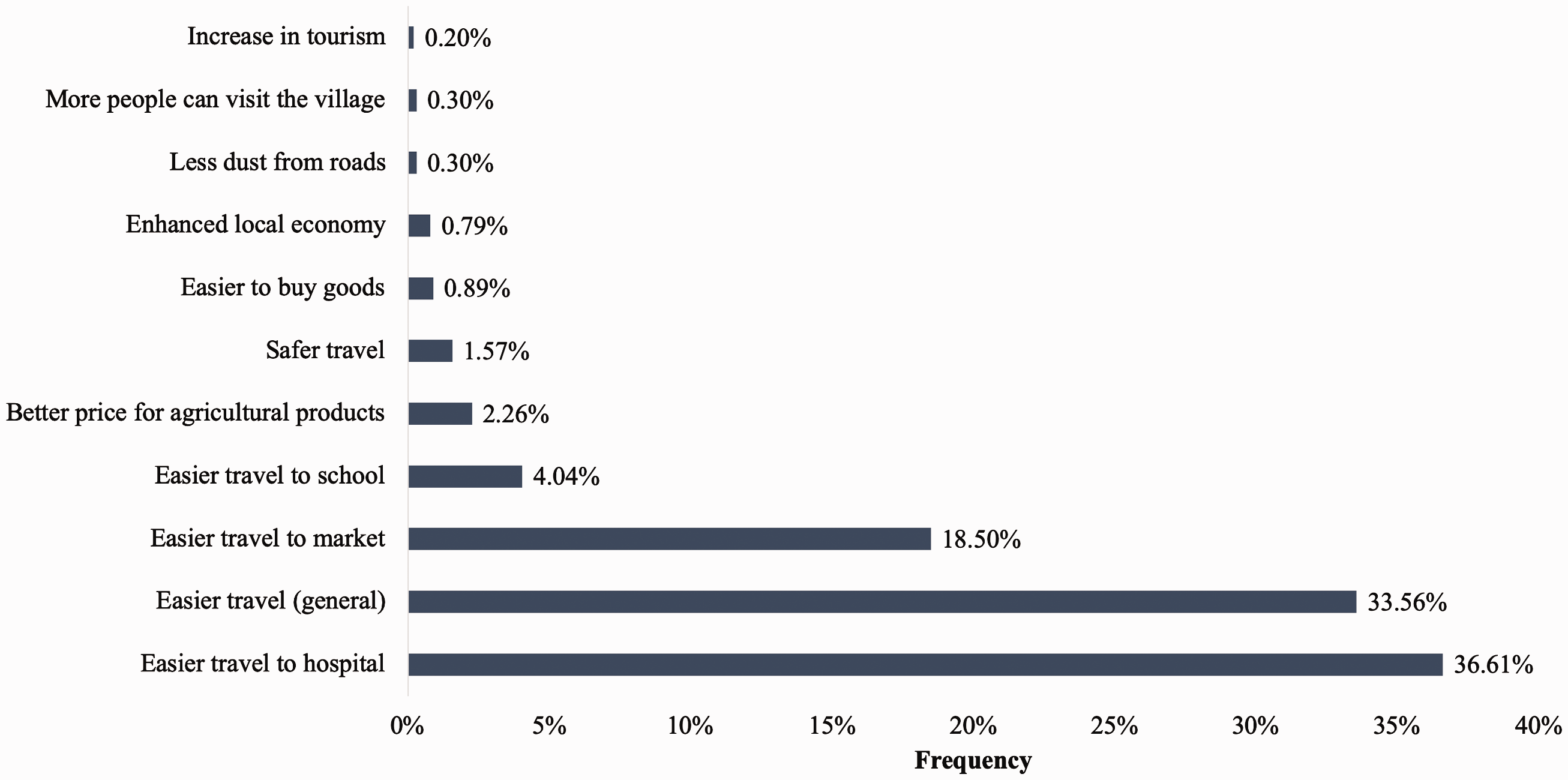
Positives good roads as perceived by households. Data obtained through household survey. Responses identified by more than one household. Additional information provided in Supplementary Materials.
Logistic regression identified the household wealth index (p = .04) and current accessibility to health care (p = .03) as significantly predictors of whether a household ranked roads as the most important infrastructure development (Table 3). The odds ratio for these two variables indicates that households that ranked roads as their first priority for development were significantly poorer and more remote from health centers than other households. The model correctly classified 70.5% of household responses, including 58% of households that ranked road development as their first priority.
Locally Perceived Benefits and Risks of Roads in Keo Seima Wildlife Sanctuary
In the 20 villages located inside and on the border of KSWS, all households included in the survey identified benefits of good roads. The most frequent response was easy to travel to hospital, followed by a general statement of easier travel (Figure 4). When asked about negatives (risks) of roads, the most frequent response was traffic accidents (Figure 5). Some 136 households (22%) stated that there were no negatives of good roads. After asking respondents to identify benefits and risks of roads, we asked if they preferred to have a good road or not, without specifying the second option as no road or a bad road. All 620 participants stated they preferred to have a good road, including the 72% of respondents that identified as Indigenous.

Negatives of good roads as perceived by households. Data obtained through household survey. Responses identified by more than one household. Additional information provided in Supplementary Materials.
Household surveys were substantiated by key informant interviews in three villages. In one of the more remote villages, a previous commune chief stressed the importance of roads in improving livelihoods, noting that poor roads prevent the commune administration from providing services and human resources. Village interviews also raised important nuances in road development. For some villages in KSWS, accessibility has increased due to roads developed by companies to access concessions. People acknowledged the benefits of the roads but they also reported that the concessions led to land conflicts and logging. For other villages, road rehabilitation enabled migration to the village, increasing competition between small businesses and increasing land prices: The new road has had a negative effect on business, more people come to sell goods in cars and on motorbikes and less people come to my shop. But it is easier for me to travel. (Male shop owner)
Local Institutions and Road Development
Multiple actors are involved in decisions concerning road development in Cambodia. The majority of road development inside KSWS falls under the responsibility of the commune administration and the Provincial Department of Rural Development (PRDT). Communes have a limited budget allocated for road development and demand frequently exceeds available funding. In 2018, funding was made available to 20 villages involved in the REDD+ program in KSWS. Half of villages identified funding for road improvement, construction or maintenance as a priority. To limit environmental impact, it was agreed that REDD+ funds could contribute to repairing roads within villages, rather than new road construction and rehabilitation roads through forest and agricultural areas prone to new settlement.
Preventing the establishment of new settlements and agricultural expansion following road improvement is a core part of the KSWS conservation strategy. Rangers conduct regular patrols in KSWS, focusing on areas at risk of conversion, identified by satellite imagery or patrol observations. During interviews, the KSWS park director raised the proposition that improved roads may help reach conservation goals, as it would enable rangers to traverse a larger area of the wildlife sanctuary. He then identified major constraints for improving protection and patrol, stating the problem here is capacity and resources. KSWS rangers struggle to prevent the creation of new settlements in KSWS and are often required to investigate forest clearance after it has been identified by satellite. When we spoke with a ranger about the challenges and potential solutions, he offered a long-term perspective; It’s difficult to stop people and (the) transport of logs because they clear at night. To stop logging and clearance, people need to improve their quality of life. When they are wealthy, then they will stop logging.
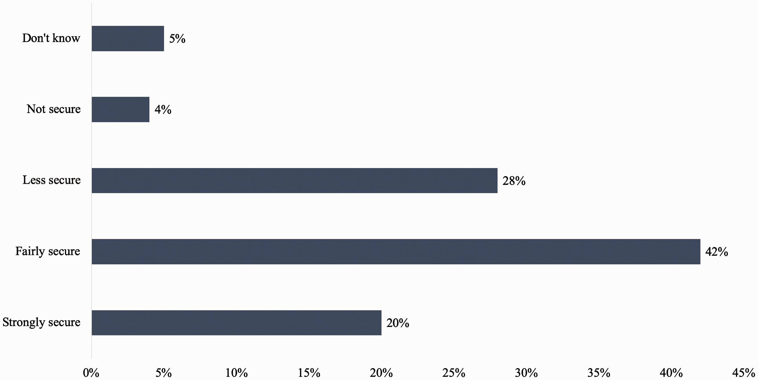
Tenure security as perceived by households. Data obtained through household survey.
Discussion
Limiting road expansion in protected areas is a difficult but often necessary trade-off to maintain biodiversity located near rural human settlements (Caro, 2015). Yet an in-depth understanding of local conditions and perceptions can aid transparent decision-making to ensure trade-offs lead to more winners and fewer losers (Reed, Van Vianen, Deakin, Barlow, & Sunderland, 2016). Our results show that local perceptions of road improvement in KSWS are closely linked to improvements in well-being, including health, education, income, and satisfaction with travel (Beauchamp, Woodhouse, Clements, & Milner-Gulland, 2018). Local people expect that as access to remote villages improves, livelihood opportunities will increase, better prices will be obtained for agricultural commodities, goods for household consumption will be cheaper, and access to health care and schools will improve. These expectations align with well-being assessments on rural road development (Duncan, 2007). The ex-post SIA 2 conducted by KfW following road rehabilitation in KSWS identifies several benefits to recipient villages, including improved income and prices for agricultural produce, easier access to schools and health-care facilities, and reduced soil erosion. Poorer households in remote villages observe this trend, prioritizing roads over other infrastructure as a way to improve their livelihoods.
From the perspective of rural development, these results are not surprising. However, they force critical reflection on the future protection of the wildlife sanctuary. In KSWS, local communities desire improvements to the current road network and government agencies are responding to rural transport infrastructure needs. Trends show that poverty is decreasing across generations, and wealthier households are more likely to generate income from sources other than agriculture (Hak, McAndrew, & Neef, 2018). In the long term, the increase in off-farm income among households may lead to land-use stabilization, reducing forest conversion (Klooster, 2003; Rudel, Perez-Lugo, & Zichal, 2000; Zhang, Zhang, Yan, & Wu, 2008). Strategically planned roads, and the provisional infrastructure that often follows, may support this trend. Examples of increased accessibility leading to land-use stabilization exist, but are rarely documented (see Acheampong et al., 2018; Kaczan, 2017). Further research is required to evaluate empirical evidence on the policies and conditions that enable this transition (Ewers, Scharlemann, Balmford, & Green, 2009; Nanni et al., 2019; Rudel, 2015).
Understanding local perception of governance, accessibility, and well-being also offers a means for strengthening support for conservation (Bennett et al., 2019). A growing body of work demonstrates the importance of incorporating local conceptualizations of human well-being into the design and practice of conservation (Beauchamp, Woodhouse, et al., 2018; Fry et al., 2017). Addressing local well-being is not only identified as an essential component of success (T. Clements, 2012), but the fulfillment of ethical obligations of conservation agencies towards local people (Milner-Gulland et al., 2014; J. G. Robinson, 2011). The most common response for benefits of road improvement, easier to travel, is similar to responses from Indigenous people of Malaysia in support of roads (G. R. Clements et al., 2018). Satisfaction with travel is linked with subjective well-being (Ettema, Friman, Gärling, & Olsson, 2016; Sapkota, 2018), especially in poor remote areas. Local communities identified traffic accidents as a significant risk of road development, consistent with growing number of fatalities from road traffic accidents in Cambodia nationwide (Kitamura, Hayashi, & Yagi, 2018).
In KSWS, local perceptions of the connection between accessibility and well-being could help to strategically target funding towards community-based conservation efforts. As identified by the ranger interviewed, pressure on forest resources in KSWS may only decrease if people meet their development aspirations. Deforestation rates in KSWS have slowed in recent years, although the cause and likelihood of this trend continuing is uncertain. If conservation agencies can continue to maintain a strong presence in KSWS, through programs such as REDD+, selective rehabilitation of roads may contribute to long-term conservation goals. This would require rigorous cost-benefit analysis to model potential gains against disruptions. For example, high vegetation density, high rainfall during the wet season and low accessibility limit effective law enforcement in protected areas (Jachmann, 2008). Roads can facilitate poaching and new settlement (G. R. Clements et al., 2014; Laurance et al., 2009; Linkie, Sloan, Kasia, Kiswayadi, & Azmi, 2014), but road networks that are easy to access by vehicle can be more cost-efficient for patrolling, especially if resources are limited (Plumptre et al., 2014).
Althrough accessible villages are exposed to social-political risks often associated with roads, respondents did not explicitly identify these in the household survey. Social tension (Bettinger, 2014), unequal benefits (Khandker et al., 2009), and illegal wildlife poaching (Wilkie, Shaw, Rotberg, Morelli, & Auzel, 2000) were not identified by respondents. However, during key informant discussions, villagers were very aware of the social disruptions associated with increased accessibility of forest areas, including logging, migration, and concession development. Interviewees supported the prioritization of roads identified in the household survey, but also shared grievances over the changing landscape. Many of these issues are symptoms of elite-driven policies that create highly unequal economic benefits, including investment in transport infrastructure (Alamgir et al., 2017). Logging and illegal exportation of high value timber such as Siamese Rosewood (Dalbergia cochinchinensis) inside protected areas has been the subject of multiple government and non-government investigations (Global Witness, 2015; Milne, 2015). Logging and its consequences are closely linked with agroindustrial concessions, which have caused significant social and ecological disruptions in rural forest areas (Davis, Yu, Rulli, Pichdara, & D’Odorico, 2015; Tsujino, Kajisa, & Yumoto, 2019). In KSWS, road improvements are not the direct cause of deforestation, but they cannot be separated from the changes that have occurred in the past decade that have transformed the area (G. R. Clements et al., 2014; Mahanty & Milne, 2016).
Enhancing Opportunities for Strategic Road Development
Prioritize existing road networks
Our discussions with government actors involved in road development highlighted crucial information that could help strengthen gains and minimize environmental disruptions of roads. First, ensuring that future road development in KSWS is restricted to rehabilitating existing roads could prevent further forest fragmentation and associated negative impacts (Goosem, 2007; Laurance et al., 2009). Enforcement of this rule for intact forest adheres to the principle of avoid the first cut (Laurance, Peletier-Jellema, et al., 2015). KSWS is part of the Eastern Plains protected area network and thus is integral to maintaining intact wildlife corridors for the movement of large mammals. Villages located inside KSWS are already accessible via tracks and narrow roads in poor condition. However, this is not to say all existing roads in KSWS should be rehabilitated. Environmental impacts of wider, paved roads can be far worse than narrow tracks with partial canopy cover (Develey & Stouffer, 2001; Laurance et al., 2002; Laurance et al., 2009). An integral component of the road rehabilitation project completed by KfW was the screening phase. KfW consulted with WCS to assess environmental impacts of potential roads in KSWS. Roads that did not comply with KfW sustainability principles were withdrawn from the project.
Collaborative partnerships for impact assessment
Conservation NGOs supporting the management of protected areas in Cambodia may be well positioned to fill gaps caused by legal or procedural weaknesses in Environmental and Social Impact Assessment (ESIA). Uninhibited by government standards, nongovernment actors can provide the nuance and detail necessary to evaluate roads on an individual basis, for both broad scale and local development (Laurance, Sloan, et al., 2015; World Wildlife Fund, 2015). Yet NGOs are often limited by technical capacity and time and resources to sufficiently meet ESIA needs. Government collaboration with research organizations can bridge knowledge gaps and provide the data sets necessary for rigorous systematic analysis, including the mapping of official and unofficial road networks (Hughes, 2018; Laurance & Arrea, 2017; Meijer, Huijbregts, Schotten, & Schipper, 2018). Prioritization of projects that require ESIAs will depend on the scale of the initiative, actors involved, and potential impacts. External involvement should contribute to strengthening partnerships for strategic road development, ensuring processes enhance transparency of internal governance and do not displace government’s responsibilities and capabilities to do this in the future (Sloan, Campbell, Alamgir, Lechner, et al., 2019).
Improve capacity of local authorities
In KSWS, village authorities have the mandate to monitor migration and claims to land. In villages with communal title, an ICT committee is responsible for ensuring compliance with local regulations governing land use within ICT zones (Travers et al., 2015). Targeting and strengthening the capacity of local institutions to prevent smallholder forest clearance following road development may help to prevent negative environmental impacts. In their meta-analysis of the links between tenure and deforestation, B. E. Robinson, Holland, and Naughton-Treves (2014) found that tenure security is associated with less deforestation. In KSWS, 32% of households do not feel secure about their land. Initiatives that enhance tenure security may help mitigate long-term environmental risks of roads in KSWS, but could also accelerate resource degradation (Deacon & Mueller, 2006; Milne, 2013). Addressing tenure issues in KSWS therefore requires a careful approach, involving collaboration between rangers and local leaders to monitor and enforce compliance (Linkie et al., 2014).
Funding for maintenance
Road maintenance in tropical forests can ensure effective drainage, prevent soil movement, and reduce damage to aquatic and terrestrial ecosystems (Sessions, 2007). The household survey found that easier travel to health services was seen by the local community as a major benefit of good quality roads. Distance is a significant factor in whether households use health centers in rural Cambodia, limiting the geographic coverage of public health services (Yanagisawa, Mey, & Wakai, 2004). Health-care costs can lead to household debt and incentivize participation in illegal activities. Further research that explores health-care challenges of the 20 villages located inside KSWS is needed to fully understand the role of roads in reducing health-care costs and increasing accessibility. This information could inform future prioritization and maintenance of roads in landscape. In some cases, closure and revegetation of roads constructed for logging may reduce ecosystem disturbance (Kleinschroth, Gourlet-Fleury, Sist, Mortier, & Healey, 2015) and contribute to the prioritization of funding for maintenance (Walzer, Chicoine, & McWilliams, 1987).
Implications for Conservation
Long-term protection of biodiversity in tropical forests requires recognition of the present and future aspirations of people that live in forested landscapes. The immediate environmental costs of roads in tropical forests are undisputed, but opportunities to maximize benefits from finite road investment must be grounded in local systems. Larger scale, national conservation priority setting should be harmonized with these localized realities in ways that encompass the representative biodiversity refuges among rapidly growing and developing rural communities. The relationship between poverty, road development, and deforestation in KSWS demonstrates the need to incorporate local perceptions into long-term conservation strategies. Placing greater emphasis on the multiple dimensions of human well-being, the potential for roads to deliver long-term environmental gains deserves greater attention and requires stronger empirical evidence. Knowing the actors involved in decisions on road development and the ways in which local institutions govern subsequent impacts can support local strategies for mitigating social and environmental risks. With this information, strategic road development can support tropical forest landscapes that strive to incorporate and balance the needs of people and biodiversity.
Supplemental Material
TRC903183 Supplemental material - Supplemental material for Learning from Local Perceptions for Strategic Road Development in Cambodia’s Protected Forests
Supplemental material, TRC903183 Supplemental material for Learning from Local Perceptions for Strategic Road Development in Cambodia’s Protected Forests by Rebecca A. Riggs, James D. Langston, Jeffrey Sayer, Sean Sloan and William F. Laurance in Tropical Conservation Science
Footnotes
Acknowledgements
We thank the many individuals and organizations that contributed to this research. We are grateful for the teams that conducted the household survey, the Wildlife Conservation Society Cambodia Program for the opportunity to learn and exchange our ideas, and the Cambodian Ministry of Environment for supporting our research. We are especially thankful to the team at Keo Seima Wildlife Sanctuary for providing key insights; Setha Tan, Oliver Griffin, Harriet Washington, Sonsak Nay and Henry Travers. Thank you to KfW Development Bank for its contributions. Our deepest thanks to the families that hosted us and the individuals who shared their perspectives. This study is part of PhD research on social-ecological impacts of landscape transitions in Southeast Asia.
Declaration of Conflicting Interests
The author(s) declared no potential conflicts of interest with respect to the research, authorship, and/or publication of this article.
Funding
The authors disclosed receipt of the following financial support for the research, authorship, and/or publication of this article: Funding for this research was partially provided by the Skyrail Rainforest Foundation, QLD, Australia [23506,2018].
Supplemental material
Supplemental material for this article is available online.
Notes
References
Supplementary Material
Please find the following supplemental material available below.
For Open Access articles published under a Creative Commons License, all supplemental material carries the same license as the article it is associated with.
For non-Open Access articles published, all supplemental material carries a non-exclusive license, and permission requests for re-use of supplemental material or any part of supplemental material shall be sent directly to the copyright owner as specified in the copyright notice associated with the article.