
Abstract
The Indian Tsunami Early Warning System situated at Indian National Center for Ocean Information Services, Hyderabad, India, monitors real-time earthquake activity throughout the Indian Ocean to evaluate potential tsunamigenic earthquakes. The functions of the Indian Tsunami Early Warning System earthquake monitoring system include detection, location and determination of the magnitude of potentially tsunamigenic earthquakes occurring in the Indian Ocean. The real-time seismic monitoring network comprises 17 broadband Indian seismic stations transmitting real-time earthquake data through VSAT communication to the central receiving stations located at the Indian Meteorological Department, New Delhi, and the Indian National Center for Ocean Information Services, Hyderabad, simultaneously for processing and interpretation. In addition to this, earthquake data from around 300 global seismic stations are also received at the Indian National Center for Ocean Information Services in near-real-time. Most of these data are provided by IRIS Global Seismographic Network and GEOFON Extended Virtual Network through Internet. The Indian National Center for Ocean Information Services uses SeisComP3 software for auto-location of earthquake parameters (location, magnitude, focal depth and origin time). All earthquakes of Mw >5.0 are auto-located within 5–10 minutes of the occurrence of the earthquake. Since its inception in October 2007 to date, the warning centre has monitored and reported 55 tsunamigenic earthquakes (under-sea and near coast earthquakes of magnitude ⩾6.5) in the Indian Ocean region. Comparison of the earthquake parameters (elapsed time, magnitude, focal depth and location) estimated by the Indian Tsunami Early Warning System with the US Geological Survey suggests that the Indian Tsunami Early Warning System is performing well and has achieved the target set up by the Intergovernmental Oceanographic Commission.
Keywords
Introduction
Tsunamis are infrequent high-impact events that can cause a considerable number of fatalities, inflict major damage and cause significant economic loss to large sections of the coastlines. Under-sea earthquakes account for nearly 85% of the world’s tsunamis (Whitmore et al., 2008), and tsunamis are less commonly caused by submarine landslides, infrequently by submarine volcanic eruptions and very rarely by a large meteorite impact in the ocean (Nayak and Kumar, 2011). The Indian Ocean tsunami of 26 December 2004 killed over 230,000 people and displaced more than 1 million people. In India, the tsunami devastated the coastal communities in Kerala, Tamil Nadu, Andhra Pradesh, Puducherry, and the Andaman and Nicobar Islands claiming nearly 18,000 lives (National Disaster Management Authority (NDMA), 2010). In response to this great tragedy, the Government of India established the Indian Tsunami Early Warning System (ITEWS) at the Indian National Centre for Ocean Information Services (INCOIS), Hyderabad (Gupta, 2005). The ITEWS comprises a real-time network of seismic stations, tsunami buoys, tide gauges and a 24 × 7 operational tsunami warning centre to detect tsunamigenic earthquakes, to monitor tsunamis and to provide timely advisories with back-end support of scenario database, vulnerability modelling and decision support system (Kumar et al., 2010).
The concept
Within any tsunami early warning concept, but mainly for a warning system for near-field tsunamis, the earthquake monitoring system plays a central role (Hanka et al., 2006). The time available to warn the population in the near-field regions like the Andaman and Nicobar Islands after a tsunami has been generated by a large earthquake is extremely short since the expected tsunami travel times are only of the order of 20–30 min or even less. Therefore, tsunami watch or warning bulletins should be issued preferably within 10–15 min in order to be able to initiate timely civil protection measures. These bulletins will initially be based primarily on rapidly determined earthquake parameters and on selected pre-calculated tsunami scenarios which fit the initial seismic parameters (Behrens et al., 2010). The sea level sensor data will be used in the later bulletins to warn the far field regions like the Indian mainland. These sea level data will also be used to validate the model results and also help in giving the final ALL Clear advisory.
The seismic network
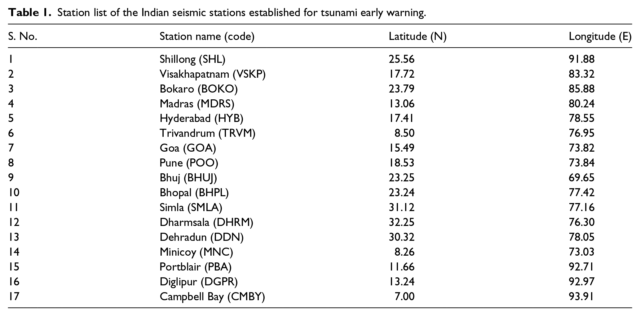
Observation of the historical earthquake data sets in the Indian Ocean region indicates two potential source regions, namely, the Andaman–Nicobar–Sumatra island arc and the Makran subduction zone north of the Arabian Sea (Nayak and Kumar, 2008). The east and west coasts of India and the island regions are likely to be affected by tsunamis generated mainly by subduction zone–related earthquakes occurring in these zones (Figure 1). In order to monitor earthquakes occurring in these regions and to estimate earthquake parameters with reasonable accuracy in the shortest possible time, a well-distributed network of broadband seismic stations communicating data in real-time is vital for the tsunami early warning system. INCOIS has established a land-based network of 17 seismic stations (Figure 2) in collaboration with the Indian Meteorological Department (IMD), New Delhi. All these stations transmit real-time data through VSAT communication to the central receiving stations (CRSs) located at IMD, New Delhi, and INCOIS, Hyderabad, simultaneously for processing and interpretation. The stations are listed in Table 1. In order to have good azimuthal coverage of stations for quick and precise estimation of the earthquake parameters, the ITEWS has also configured stations from internationally coordinated networks like the IRIS, GEOFON and GSN networks, where real-time data are received through the Internet.
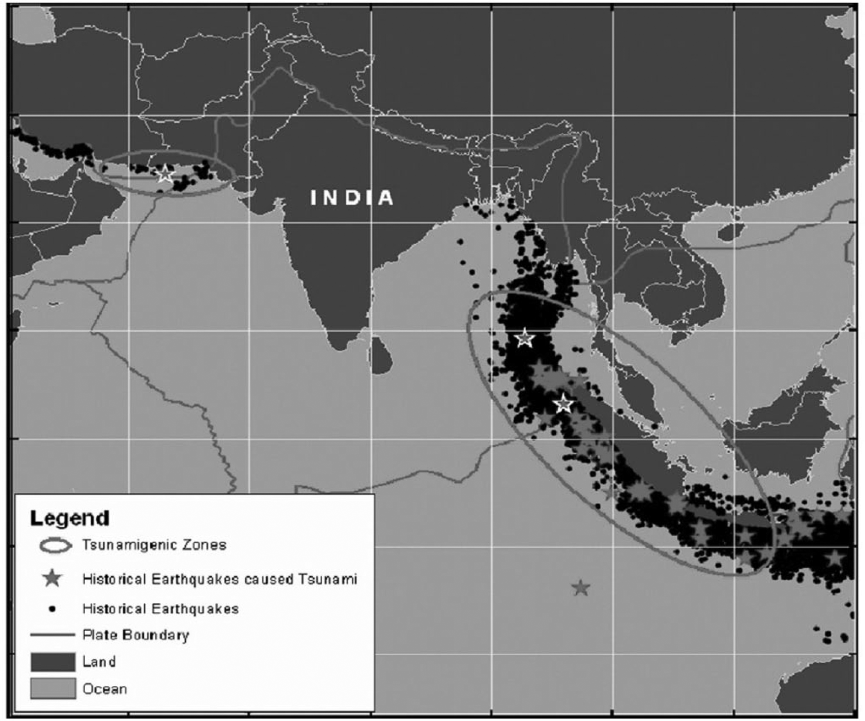
Historical seismicity indicating the tsunamigenic source regions in the Indian Ocean.
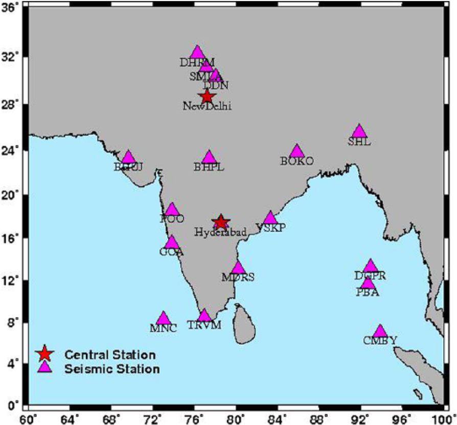
Location map of the Indian seismic stations for tsunami early warning.
Station list of the Indian seismic stations established for tsunami early warning.
Station configuration
Each field station is equipped with Trillium 240 broadband seismometer, Taurus seismograph, and necessary power and communication facilities. The seismometer is well covered with thermal insulation and kept on ‘pier’ for direct contact with hard rock on the ground and shielded perfectly to avoid the thermal and pressure fluctuations and to protect it from other atmospheric effects. The seismometer continuously records ground motion with 100 samples/s in the frequency range of 0.01–50 Hz with constant frequency response. The recorded data are stored in the Taurus seismograph and transmitted continuously in automatic mode to the CRS through VSAT communication. The CRSs are equipped with state-of-the-art computing hardware, communication, data processing, visualisation and dissemination facilities. The field equipment can be accessed from the CRS remotely at any point of time and perform functions such as calibration of sensors including centring of mass, inspecting the state of health and downloading the seismic data from field stations. The schematic diagram at each station is given in Figure 3.
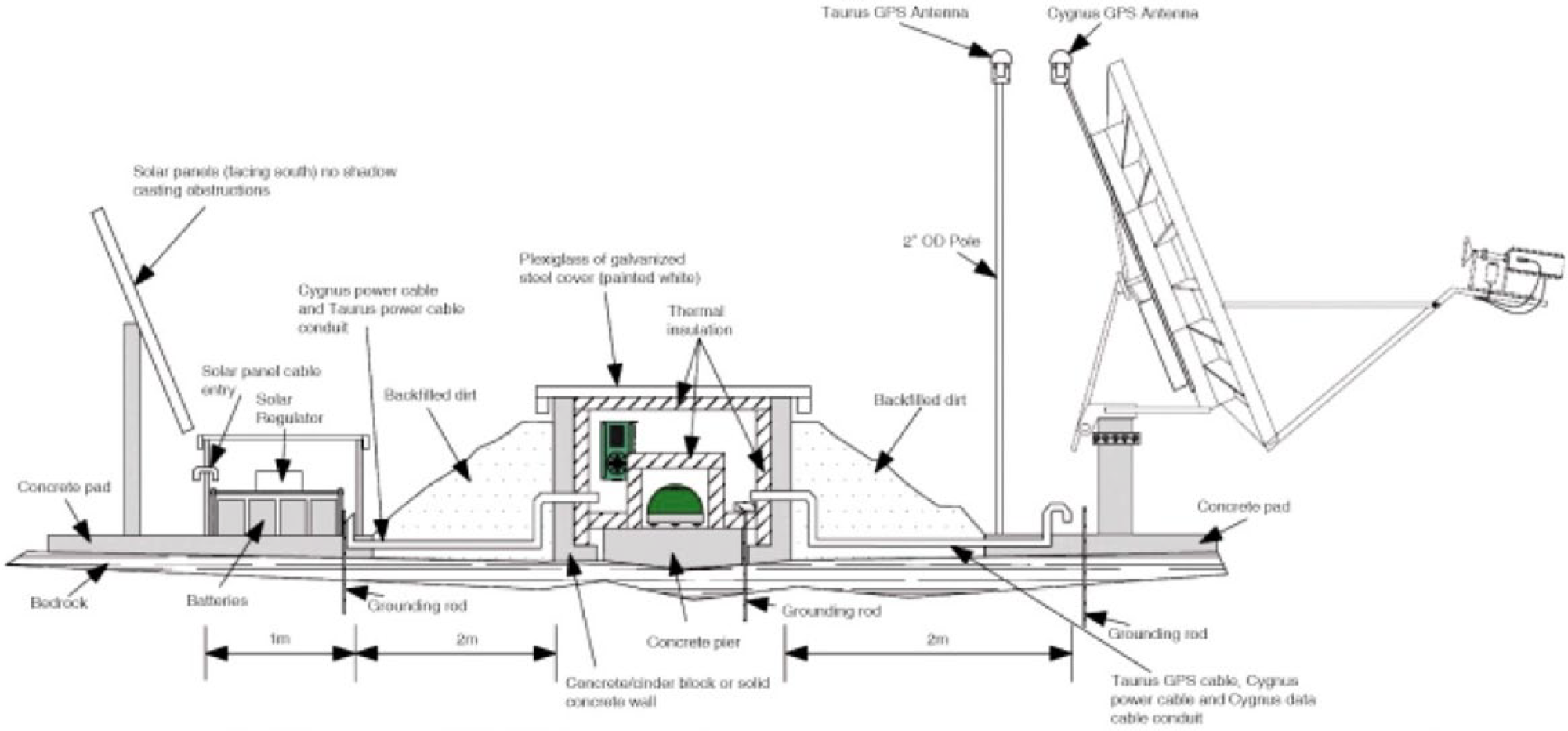
Schematic diagram of broadband sensor set-up at each field station.
Real-time data processing
The real-time seismic data received at the ITEWS have to be quickly processed for the estimation of the earthquake parameters. SeisComP3 software is configured for real-time data reception, archiving, processing and auto-location using the national and international stations. Any earthquake of magnitude >5.0 occurring on the globe is auto-located within 5–10 min using this software. The earthquake parameters are displayed (Figure 4) with an alarm notification to alert the warning centre operators. The system can compute almost all types of magnitudes such as the local magnitude (ML), body wave magnitude (mb), broadband body wave magnitude (mB), broadband p-wave magnitude (Mwp), surface wave magnitude (MS) and moment magnitude (Mw). After the auto-location is given by the system, the operators can review the earthquake waveforms to refine the auto-located parameters and the focal mechanism can be computed to know the tsunamigenic potential of the under-sea earthquake.
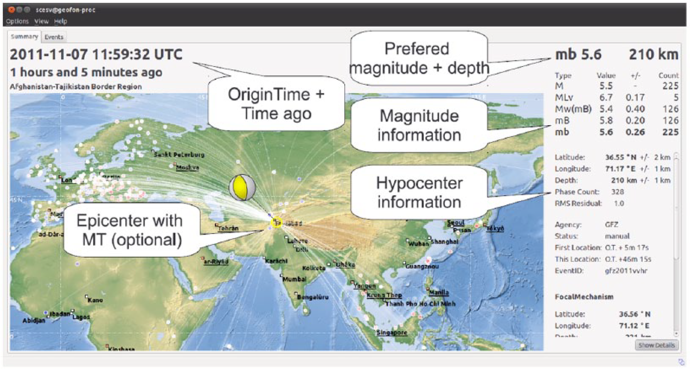
Earthquake summary display in the SeisComP3 software.
The ITEWS has been recognised as one of the Regional Tsunami advisory Service Providers (TSP) for the Indian Ocean region on 12 October 2011 by the Intergovernmental Oceanographic Commission (IOC) of the United Nations Educational, Scientific and Cultural Organization (UNESCO). As part of its regional services, the ITEWS compares its estimated earthquake parameters (elapsed time, magnitude, focal depth and location) with those of the US Geological Survey (USGS) to maintain its regional performance (targets set by IOC-ICG/IOTWS-V/13, 2008). Since its inception in October 2007 till 31 May 2015, ITEWS has monitored 475 earthquakes of magnitude ⩾6.5 all over the globe (both land and ocean). Out of these earthquakes, 55 are in the Indian Ocean region (both Ocean and near coast). A summary of the performance of the warning centre against key performance indicators since it attained regional status, that is, since 12 October 2011 (22 earthquakes), is given in Table 2.
Summary of the performance levels achieved by the ITEWS as criteria given by the IOC.
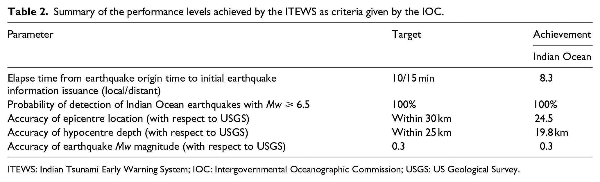
ITEWS: Indian Tsunami Early Warning System; IOC: Intergovernmental Oceanographic Commission; USGS: US Geological Survey.
It is evident from Table 2 that the parameters estimated by the ITEWS seismic network are very well within the target set up by IOC-ICG/IOTWS-V/13. Elapsed time is the time span between origin time of the earthquake and initial earthquake information issuance. It is observed that the average elapsed time of the ITEWS is 8.3 min, which is within the target of 10/15 min, while the USGS has an elapsed time of 10 min. The average difference in magnitude of the ITEWS estimate with the USGS is 0.30, which also achieves the target of 0.3. The average focal depth difference with the USGS is 19.8 km (Figure 5(a)), which is within the target value of 25 km. A comparison of earthquake location estimated by the ITEWS with the USGS indicates that the average difference in location is within the target of 30 km (Figure 5(b)).
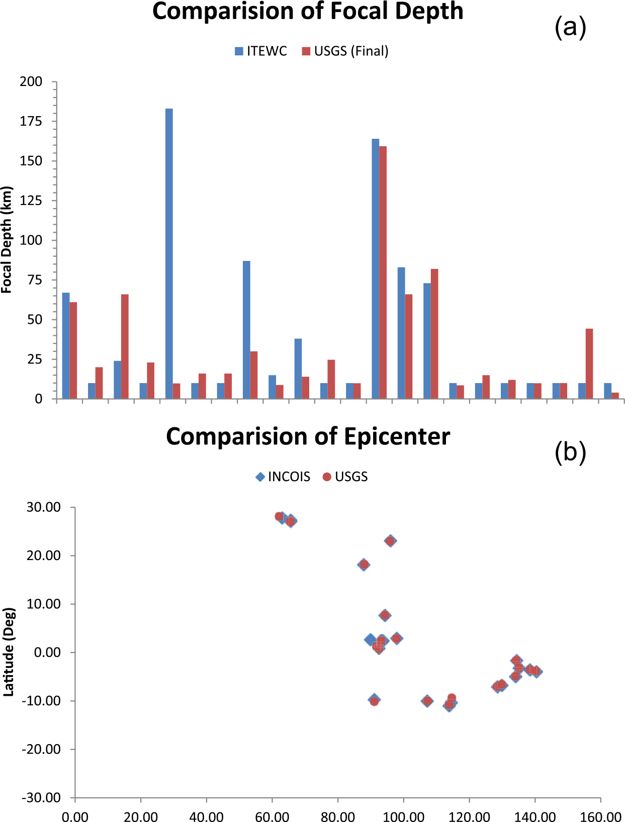
Plot of the ITEWS earthquake parameters with the USGS estimated values: (a) focal depth and (b) epicentre location.
As a case study, we will discuss the ITEWS performance during the large strike-slip earthquakes of magnitude Mw (mB) 8.5 and 8.2 that occurred on 11 April 2012 in the Indian Ocean region. The former earthquake generated a small ocean-wide tsunami that has been recorded by various tide gauges and tsunami buoys located in the Indian Ocean region. The ITEWS detected this earthquake within 3 min 52 seconds and located it within 7 min from its occurrence with the help of ‘SeisComP3’ auto-location software. The initial magnitude of this earthquake was estimated as Mw (mB) 8.7 with a focal depth of 10 km. Both the national and regional earthquake information bulletins were issued after 8 min of the occurrence of the earthquake which is within the target of 10/15 min prescribed by the IOC. The earthquake parameters were reviewed, and considering the tsunami model results, the second bulletin was issued at 12 min with the revised earthquake magnitude as Mw (mB) 8.5 with threat information considering the earthquake as thrust fault as it occurred in the subduction zone. Furthermore, the real-time waveforms were analysed and noted that the earthquake occurred with strike-slip faulting and concluded there was no threat of an ocean-wide tsunami. But considering the tsunami model results and the real-time sea level observations, only a few parts of Andaman and Nicobar Islands were advised to evacuate. The ITEWS issued further bulletins according to its Standard Operating Procedure and avoided unnecessary evacuations to the mainland. This event once again proved the efficiency of the ITEWS.
Summary
The ITEWS established at the INCOIS with all the necessary computational and communication infrastructure is performing satisfactorily since its inception in October 2007. The real-time seismic monitoring network is continuously providing data and achieved its design goals. The earthquake monitoring capability of the ITEWS is significantly improved with the real-time seismic network, in particular with respect to the potential tsunamigenic earthquake–generating regions.
Footnotes
Acknowledgements
We would like to express our sincere thanks to the Director, INCOIS, for his constant support. We thank the Ministry of Earth Sciences (MoES), New Delhi, for support and encouragement and our colleagues at IMD, SOI, NIOT, INCOIS and MoES for support in developing and operating this state-of-the-art system. Some of the figures have been generated using GMT freeware developed by Paul Wessel and Walter H.F. Smith.
Declaration of conflicting interests
The author(s) declared no potential conflicts of interest with respect to the research, authorship and/or publication of this article.
Funding
The author(s) received no financial support for the research, authorship and/or publication of this article.