
Abstract
A systematic study of geophysical data of the Eastern Continental Margin of India was taken up to identify the land–ocean tectonic lineaments over the east coast of India and the possible neotectonic activity associated with them. These studies helped in delineating the offshore extension of some of the coastal lineaments. Analysis of magnetic, gravity and shallow seismic data, combined with reported seismicity data, indicates moderate seismicity associated with some of these land–ocean tectonics of the Eastern Continental Margin of India. The coastal/offshore regions of Vizianagaram (north of Visakhapatnam) and Ongole of the Andhra Pradesh margin and the Puducherry shelf of the Tamil Nadu margin have been identified as zones of weakness where neotectonic activity has been established. Bathymetry data over the Eastern Continental Margin of India revealed the morphology of the shelf and slope of this margin, which in turn can be used as the baseline data for tsunami surge models. Detailed bathymetry map and sections of the Nagapattinam–Cuddalore shelf (from 10.5° to about 12°N) indicate that one of the main reasons for the higher run-up heights and inundation in the Nagapattinam–Cuddalore coast during the Indian Ocean Tsunami of 26 December 2004 could be the concave shape of the shelf with a gentle slope, which might have accelerated the tsunami surge to flush through at a rapid force. Structural control also appears to be a contributing factor for the tsunami surge.
Introduction
The Indian Ocean Tsunami of 26 December 2004 caught us off guard on several aspects. Not only with the absence of a Tsunami Warning System, but we also did not have substantial data on the morphology, structure and coastal seismicity of our coastal areas. These data are very essential for identifying the areas vulnerable to higher tsunami surge, the expected surge heights at these locations and also to demarcate seismic hazard zones in the coastal areas, which might get reactivated due to the impact of major earthquakes such as the Sumatra event.
The Sumatra earthquake of magnitude more than 9.3 on the Richter scale and some of the stronger aftershocks shook the coastal areas of the east coast of India. Even the recent earthquake of 21 May 2014 in the deep sea Bay of Bengal created tremors over much of the coastal cities of east coast of India. Even though the Eastern Continental Margin of India (ECMI) is a passive margin with no record of significant seismic activity, the major earthquakes in the vicinity of this margin, particularly at the convergent boundary along the Andaman–Sumatra–Java Trench, are likely to have an impact on the weak structural lineaments extending from the coast to offshore. The compressional stress regime acting over the Indian Plate due to its continuous northward movement is another factor for some of the intraplate earthquakes in the South Indian Shield, which includes the Eastern and Western Continental Margins of India.
Material and methods
Baseline marine geophysical data over the ECMI
Since 1985, the Marine Geophysics Group of the National Institute of Oceanography (NIO) at Visakhapatnam has carried out extensive geophysical surveys over the ECMI and the Bengal Fan. Bathymetry, magnetic, gravity and high-resolution seismic surveys were carried out over the ECMI. In addition, the offshore basins (Cauvery, Krishna–Godavari and Mahanadi) and non-basinal areas (Visakhapatnam–Kalingapatnam shelf) of ECMI were covered by detailed studies. These data sets were utilized to explain the evolution, tectonics and associated hazards of a passive margin (Murthy et al., 2012). The detailed data over the offshore river basins have been used to delineate the offshore extension of some of the Pre-Cambrian Tectonic lineaments (Subrahmanyam et al., 2006). In addition, the data over the shelf/slope have been utilized to understand the seabed morphology and to analyse the seismic hazards associated with some of the land–ocean tectonic (LOT) lineaments (Murthy et al., 2012).
Results
Coastal seismicity
A systematic study of geophysical data of the ECMI was taken up to identify the LOT lineaments over the east coast of India and the possible neotectonic activity associated with them. These studies helped in delineating the offshore extension of some of the coastal lineaments (Figure 1).
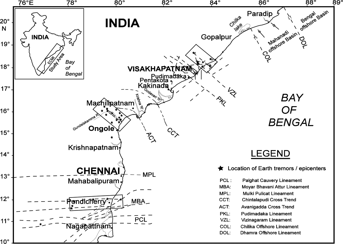
Land–ocean tectonic lineaments over the ECMI (Murthy et al., 2010, 2012). Rectangular blocks represent areas identified with seismicity.
Analysis of magnetic, gravity and shallow seismic data, combined with reported earthquake data, indicates moderate seismicity associated with some of these LOTs of ECMI (Murthy et al., 2010, 2012). The coastal/offshore regions of Vizianagaram (north of Visakhapatnam) and Ongole of the Andhra Pradesh margin and the Puducherry (also called as Pondicherry) shelf of the Tamil Nadu margin have been identified as zones of weakness where neotectonic activity has been established (shown as three rectangular blocks in Figure 1). While Earthquake data over the coastal and offshore areas of Visakhapatnam (including the Vizianagaram part) indicate moderate seismicity (with magnitude of tremors of the order of 3–4.5), the Puducherry offshore experienced an earthquake of magnitude 5.5, in 2001, which was a fairly larger event for the South Indian shield (Murty et al., 2002; Subrahmanyam et al., 2007). These results are useful in estimating the coastal stability of different parts of the east coast of India.
Geomorphology
Bathymetry data over the ECMI revealed the morphology of the shelf and slope of this margin, which in turn can be used as the baseline data for tsunami surge models. A comprehensive bathymetry contour and section map was generated for the entire ECMI (Figure 2(a) and (b)), with details of shelf break, shelf width and slope gradient at different locations (Table 1).
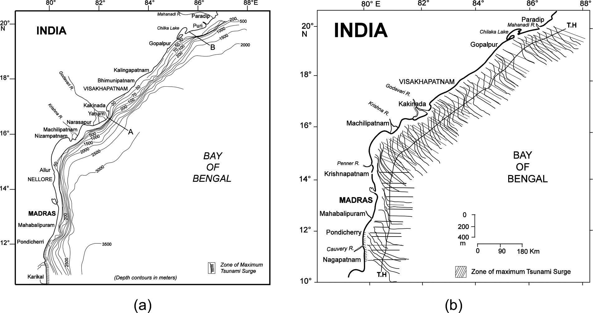
(a) Bathymetry contour map of ECMI (Murthy et al., 2012) and (b) bathymetry sections over the ECMI (Murthy et al., 2012).
Shelf/slope characteristics off selected places over the ECMI (Murthy et al., 1993).
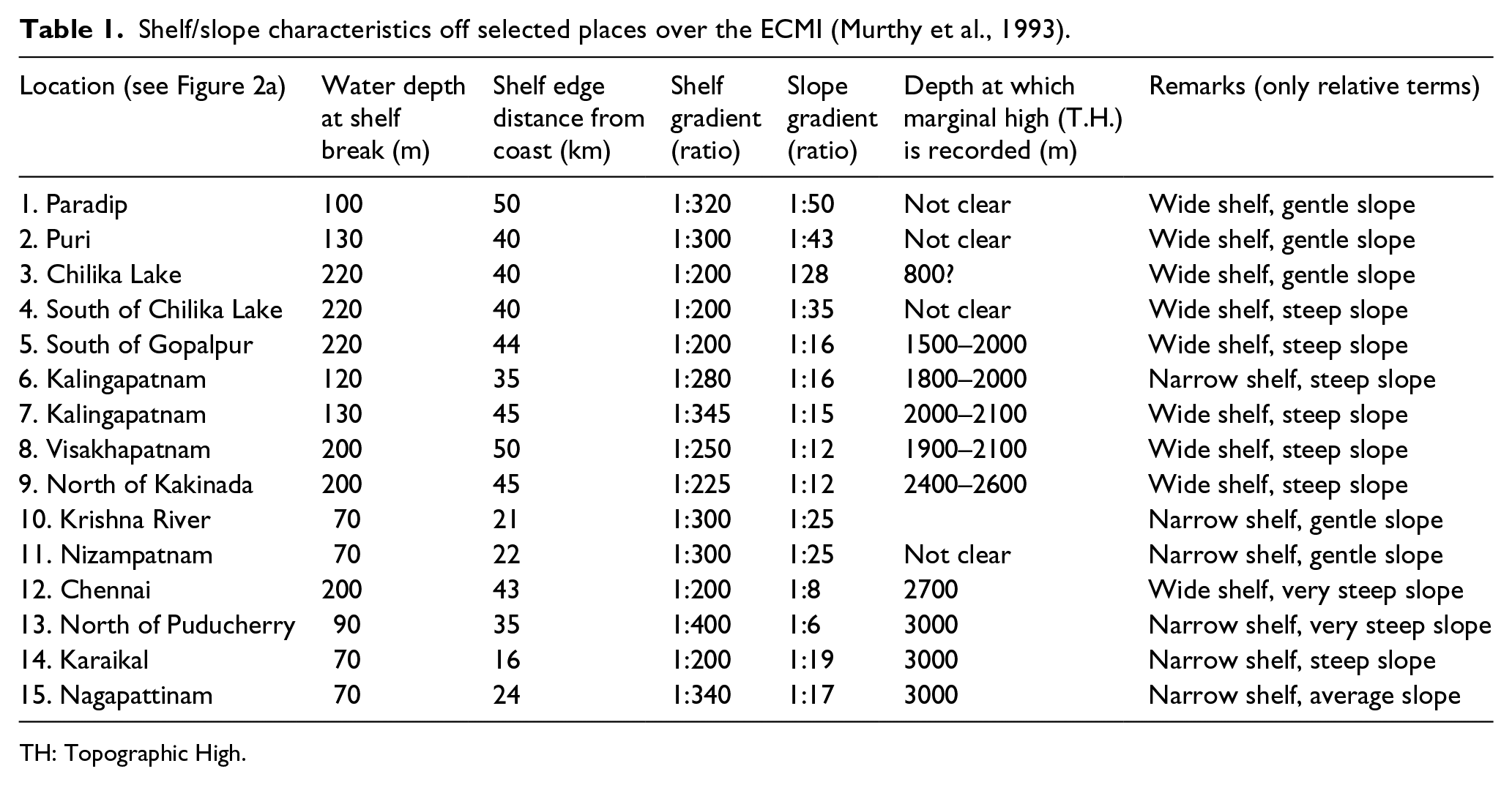
TH: Topographic High.
Morphologically, the ECMI represents a mosaic of basinal and non-basinal segments. The depth contours of the eastern continental margin nearly follow a north–south (N–S) trend in the southern part between Karaikal (10°55′N) and Nellore (14°30′N) from where they take a northeast–southwest (NE–SW) trend up to Paradip (20°15′N) in the north, thus running sub-parallel to the coastline (Figure 2(a)). The contours indicate, in general, a narrow shelf in the south from Karaikal (10°55′N) to Nellore (14°30′N), also off the Krishna and Godavari river basins, and a relatively wider shelf to the north from Kakinada to Paradip.
Detailed bathymetry map and sections of the Nagapattinam–Cuddalore shelf (from 10.5° to about 12°N) indicate (Murthy, 2011; Murthy et al., 2006a, 2006b) that one of the main reasons for the higher run-up heights and inundation in the Nagapattinam–Cuddalore coast (affected area marked in hatches in Figures 2 and 3) during the Indian Ocean Tsunami of 26 December 2004 could be the concave shape of the shelf with a gentle slope, which might have accelerated the tsunami surge to flush through at a rapid force (Figure 3(a) and (b)).
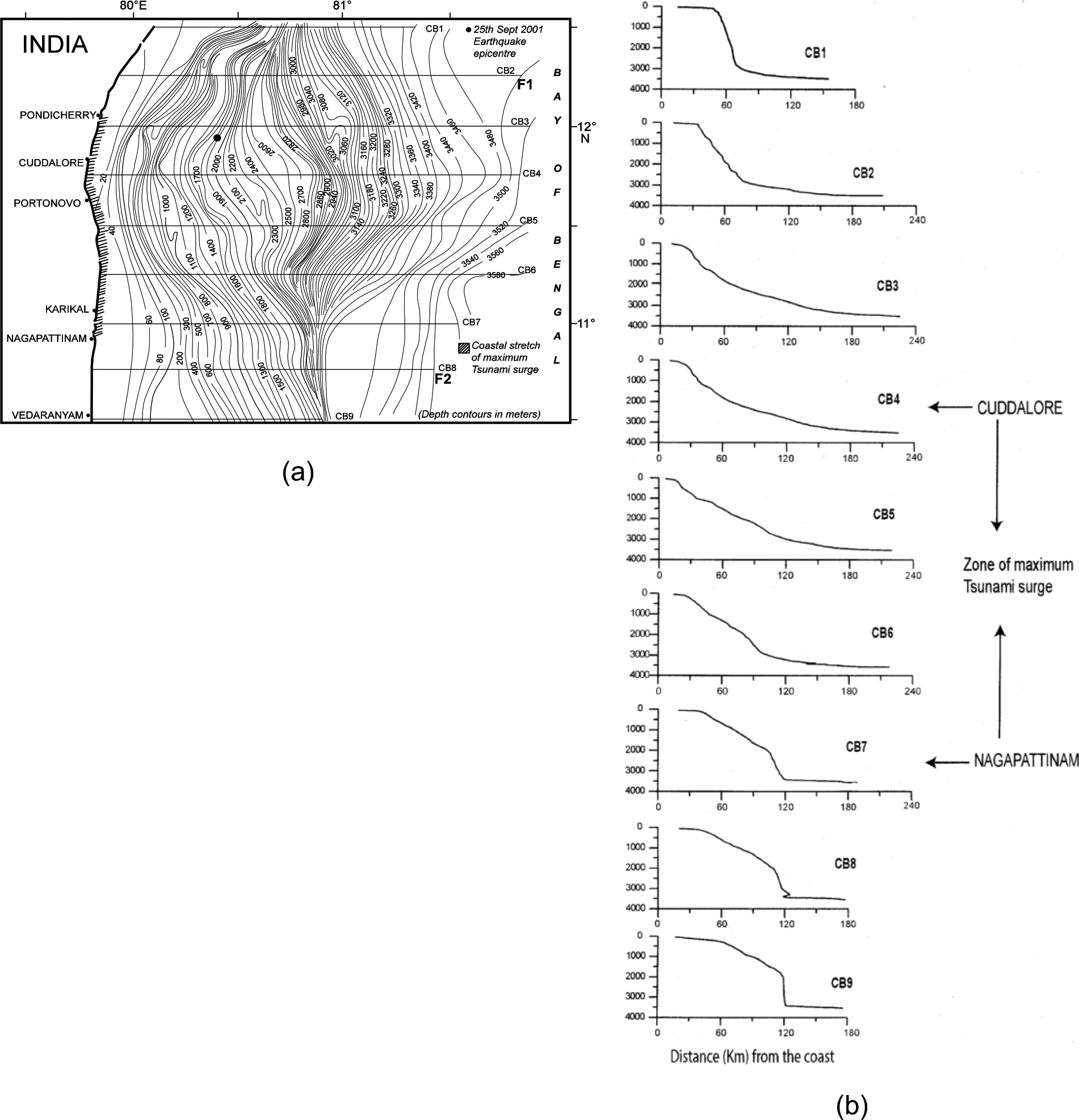
(a) Detailed bathymetry map of the Cauvery Basin, Tamil Nadu coast (Murthy et al., 2006b) and (b) bathymetry sections over the offshore Cauvery Basin (Murthy et al., 2006b).
The sections off Vedaranyam in the south and that in the north of Puducherry indicate a wider shelf with steeper slope, representing the southern and northern boundaries of the concave shelf. The area within these boundaries is more affected by the tsunami surge.
The earliest bathymetry observations over the offshore Cauvery basin revealed the presence of submarine canyons off Cuddalore and Puducherry (Varadachari et al., 1968). Subsequent geophysical studies also suggested that major valleys off Puducherry are formed due to the existence of mega lineaments (Rao et al., 1992). The lineament pattern played a major role in shaping the continental slope morphology, besides erosional and depositional processes. Bastia et al. (2011), from multi-channel seismic reflection data off the ECMI, concluded that the slope instability and slope canyons are the important geohazards throughout the east coast of India, particularly off the river basins. The high run-up heights and inundation in case of the Nagapattinam and Cuddalore shelf are therefore due to favourable seabed morphology, which in turn is the result of the faulted basement structure.
Conclusion
Hazard management of coastal areas requires systematic data collection and continuous monitoring of different oceanographic processes and their impact on the coastal morphology, in particular on the stability of the coastal zone. The ECMI represents a mosaic of basinal and non-basinal morphology and is affected by both oceanographic processes and deltaic processes. The geodynamic processes of this passive margin since its evolution defined the shape of the present coastline. The Pre-Cambrian onshore tectonic lineaments have their offshore expression and most of the offshore river basins are confined within these lineaments. The morphology of the continental shelf off the river basins is dominated with the presence of submarine canyons, sediments slumps, slope failures and other such marine geohazards, which need to be studied in detail. Three zones of neotectonic activity with reported micro-seismicity were identified over the ECMI: off Puducherry, Ongole and Visakhapatnam (Vizianagaram shelf). Coastal erosion due to eustatic sea level changes as well as due to human interference is also a major hazard over the east coast.
Footnotes
Acknowledgements
This work was carried out as part of the IITB-CSIR-NIO collaborative project sponsored by the Ministry of Earth Sciences (MoES/P.O. (Seismo)/1(141) 2011).
Declaration of conflicting interests
The author(s) declared no potential conflicts of interest with respect to the research, authorship and/or publication of this article.
Funding
The author(s) disclosed receipt of the following financial support for the research, authorship, and/or publication of this article: This work is supported by the Ministry of Earth Sciences.