
Abstract
This article discusses the recent developments in modelling and simulations for analyses of airspace structures and traffic flows. The topics discussed are new models/methods proposed by researchers in the world for optimal flight paths/routes, optimal route structures, sectorization and so on and also new developments in the Association of Southeast Asian Nations region. An Association of Southeast Asian Nations modelling and simulation function has been established, so as to perform analyses of airspace structures and traffic flows throughout the Association of Southeast Asian Nations and produce solutions for capacity and efficiency enhancements. The challenges for such research in the Association of Southeast Asian Nations region are also discussed. This review has helped to identify the research gap. The research on air traffic management in the Association of Southeast Asian Nations region is still lacking. Much more efforts should be made in order to meet the demands of this most dynamic and fast growing aviation market in the world. Research on optimal flight paths/routes, more efficient airspace structures and sectorization is expected to be more intensively conducted especially in the Association of Southeast Asian Nations region.
Keywords
Introduction
With the surge of low-cost carriers (LCCs), studies have been conducted on how they may affect the efficiency of air traffic. Choo and Oum 1 found that airports with the increasing number of LCCs actually had decreasing efficiency. Hence, more studies should be conducted to increase the efficiency of air transport operations with increasing LCCs. 2 The profitable adaptation of LCCs to long-haul flight operations is also under intensive discussions, and regular long-haul operation LCCs are possible if appropriate trunk routes are determined and full-service carrier (FSC) products are not bundled. 3 The fares are affected by the competition where the route is provided, and FSCs tend to reduce fares on the routes that are also offered by LCCs. 4
The transfer cost, market capacity and relative location of cities are important elements influencing competition and cooperation, 5 and travellers normally choose routes in order to reduce the travel cost as much as possible. As passengers sensitively respond to the service level offered, airlines must understand passenger’s behaviour of selecting routes. 6
The airport capacity is a largest threat facing the expansion plans of airlines as airports have witnessed exponential growth, and the associated risks include congestion, delays and dissatisfied passengers. 7 The competing high-speed rail links and the access to airport slots are the most efficient entry obstructions within the European market, 8 and significantly congested airports in Europe and the United States are crucial elements for restraining entry into a certain route.
Corporatization, diversification and low-cost transport enhance the ability of airports to govern costs. 9 To deal with the growth of air passengers throughout the world, it is crucial to know passenger flows to forecast future service levels and capacity constraints. 10 It is important to determine vulnerabilities to climate changes and develop programs to adapt to climate changes and mitigate climate impacts, 11 and seasonal forecasts can be employed for strategic schedule/route planning.
The continuous growth of the gross domestic products (GDP) influences the air traffic increase as well. 12 The region where the author of this article is related to is believed to be one fastest growing aviation market in the world. The air traffic demand in the Association of Southeast Asian Nations (ASEAN) region is growing tremendously. The air traffic is forecasted to triple in the region by 2033. 13
However, until recent years, systematic research on air traffic flow management was lacking in this most dynamic and fast growing aviation market in the world. Therefore, this overview paper reviews the recent developments in modelling and simulations for analyses of airspace structures and traffic flows, with the hope to identify the research gap. Recent developments/findings and new methods published recently in the world are reviewed and summarized. Then, the new developments in modelling and simulations for analyses of airspace structures and traffic flows in the ASEAN region are presented. The challenges for such research in the ASEAN region are also discussed.
New models/methods proposed for optimal flight paths/routes
Research on optimal flight paths/routes is intensively carried out, which is summarized in Table 1 and briefly discussed in this section.
Summary of new models/methods proposed by researchers for optimal flight paths/routes.
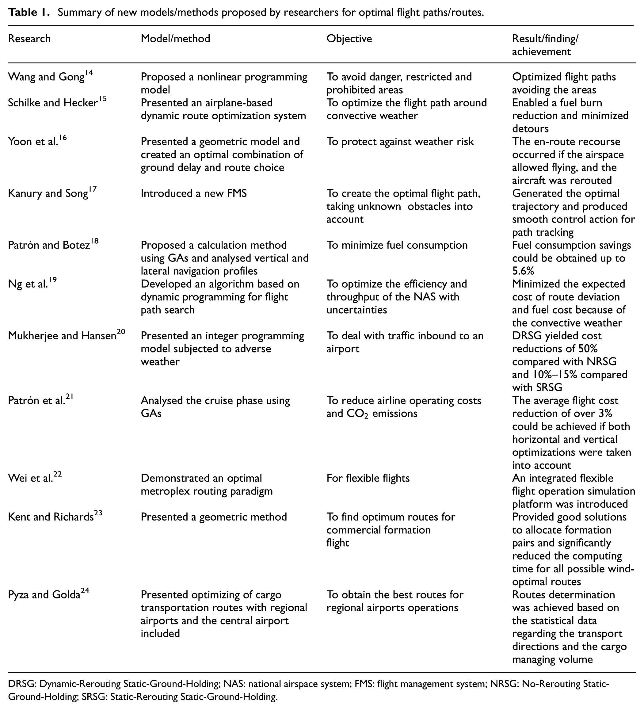
DRSG: Dynamic-Rerouting Static-Ground-Holding; NAS: national airspace system; FMS: flight management system; NRSG: No-Rerouting Static-Ground-Holding; SRSG: Static-Rerouting Static-Ground-Holding.
To avoid danger, restricted and prohibited areas under the condition of the operating cost and flight safety, Wang and Gong 14 proposed a nonlinear programming model for air route network (ARN) nodes based on the cellular automata (CA) theory with the neighbours of Moore and found the solution for the model by minimizing an objective function being the shortest path of the ARN. They optimized flight paths H33, B458 and A596 in part of the airspace of China, avoiding danger, restricted and prohibited areas.
Schilke and Hecker 15 presented an airplane-based dynamic route optimization system that optimized the flight path around bad weather, based on updated weather forecasts transmitted to the aircraft through the data link. This approach enabled a fuel burn reduction and minimized detours.
Yoon et al. 16 proposed a geometric model to protect against weather risk and created an optimal combination of ground delay and route choice. The model had four parameters (ground–airborne cost ratio, maximum storm duration time, storm size, storm location) and two decision variables (route choice, ground delay). If a uniform distribution was followed by the weather clearance time, the model permitted route hedging, ground delay and recourses. The objective function included expected total airborne and ground delay costs. A solution algorithm resulted in the global optimum of the model. The en-route recourse occurred if the airspace allowed flying and the aircraft was rerouted.
Kanury and Song 17 presented a new flight management system (FMS), which produced the optimal trajectory and created smooth control actions for path tracking. Given the target positions, genetic algorithms (GAs) were adopted to create the flight path, taking unknown obstacles into account. They also developed a memory-based control strategy to guide the vehicle along the created trajectory, which was dynamically adjusted based on the changing flight conditions.
Patrón and Botez 18 proposed a calculation method using GAs and analysed vertical and lateral navigation profiles to minimize fuel consumption. They generated a three-dimensional (3D) grid around the original flight trajectory to calculate the optimal trajectory during the cruise phase to reduce carbon emissions and flight costs. Waypoints in the grid were represented by altitude, longitude and latitude. With the performance databases for commercial aircraft, various flight trajectories were calculated using GAs to reduce computational time and power. After cycles of elimination, the most-fitted individual would be the optimal solution. Simulation results showed that fuel consumption savings could be obtained up to 5.6%.
Ng et al. 19 proposed an algorithm for flight path search based on dynamic programming, which employed the forecast probability that an airplane would avoid convective weather. The algorithm optimized the efficiency and throughput of the national airspace system (NAS) with uncertainties. The optimized routes were alternatives to the departure routes, rerouted pre-departure flights around air traffic constraints or weather and minimized the expected cost of route deviation and fuel cost because of the convective weather. These routes had the best deviation probability, which was forecast using a formula for all path candidates.
Mukherjee and Hansen 20 presented an integer programming model subjected to adverse weather to deal with traffic inbound to an airport. They used the weather information provided by probabilistic weather forecasting tools. The model solutions were input to a resource allocating algorithm, which determined release times and routes to airlines or flights. The optimization model supported the decision-making for flight rerouting and ground holding during instances of adverse weather and allowed the dynamic decision-making process that updated itself based on evolving information of current future weather. Three different models were considered, namely Dynamic-Rerouting Static-Ground-Holding (DRSG), Static-Rerouting Static-Ground-Holding (SRSG) and No-Rerouting Static-Ground-Holding (NRSG). SRSG and NRSG were for the purposes of comparison to DRSG. The DRSG model minimized the total expected delay cost subjected to 13 constraints. The research provided reduced delay costs for controllers and users in most cases. Simulation results showed that DRSG yielded cost reductions of 50% compared with NRSG and 10%–15% compared with SRSG.
Patrón et al.
21
analysed the cruise phase using GAs because the fuel economization during the cruising phase could give reduction in airline operating costs and emissions of
Wei et al. 22 demonstrated an optimal metroplex routing paradigm for flexible flights. An integrated flexible flight operation simulation platform was introduced, which had multiple functional modules including flexible flight candidate plan estimation, flexible flight selection, scheduling and routing. The metroplex routing algorithms were implemented by constructing a network data structure from the jet routes and waypoints. Two algorithms were applied with and without the en-route traffic congestion constraint. A jet-way network data structure was constructed to design the optimum routing algorithm under the congestion constraint of the en-route traffic. The data structure was constructed from navigational aids, fixes, waypoints and jet routes obtained from the Future ATM (air traffic management) Concepts Evaluation Tool.
Kent and Richards 23 presented a geometric method to find optimum routes for commercial formation flight. They adapted the Breguet range equation for representing realistic aircraft and the weight changes due to fuel burn. They also developed a method to find wind-optimal routes in a formation flight paradigm and to evaluate the effect of the geometric estimation on the formation pair assignment. The approach provided good solutions to allocate formation pairs and significantly reduced the computing time for all possible wind-optimal routes.
Pyza and Golda 24 presented optimizing of cargo transportation routes with regional airports and the central airport included and obtained the best routes for regional airports operations. Routes determination was achieved based on the statistical data regarding the transport directions and the cargo managing volume at airports.
New models/methods proposed for optimal route structures
Table 2 summarizes the models/methods proposed by researchers for optimal route structures, which are briefly discussed in this section.
Summary of new models/methods proposed by researchers for optimal route structures.
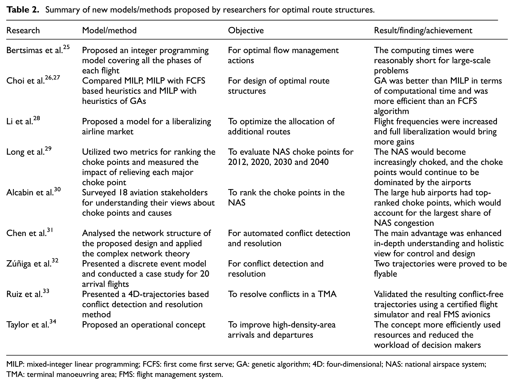
MILP: mixed-integer linear programming; FCFS: first come first serve; GA: genetic algorithm; 4D: four-dimensional; NAS: national airspace system; TMA: terminal manoeuvring area; FMS: flight management system.
An integer programming model covering all the phases of each flight and solving for optimal flow management actions was presented by Bertsimas et al. 25 It allowed rerouting decisions by the imposition of local conditions to represent rerouting options. The computing times were reasonably short for large-scale problems.
Choi et al.26,27 compared mixed-integer linear programming (MILP), MILP with first come first serve (FCFS) based heuristics and MILP with heuristics of GAs for design of optimal route structures. The objective function used was the total travel time. They found that a MILP-based scheduler generated more optimal schedules than an FCFS algorithm. But the long computing time due to the vast search process would allow it to be used only for a small number of flights. Heuristics based on FCFS scheduling could alleviate this disadvantage, but could not deal with the traffic with dense terminal operations. Therefore, they introduced a GA to decrease the computing time, by constructing a dynamic planner framework, which integrated the GA heuristics-based scheduler. 26 They found that GA was better than MILP in terms of computational time and was more efficient than an FCFS algorithm. GA-based heuristic combined with linear programming handled continuous and discrete design variables, efficient for flight trajectory optimization and for lateral and vertical integrated navigation. 27
Airlines commercial rights are governed by bilateral Air Services Agreements (ASA). Restrictions cause substantial loss. Negotiation of liberalizing ASA is lengthy and inefficient procedure. Few quantitative models can be used to develop optimal policies. Thus, Li et al. 28 proposed a model for a liberalizing airline market to optimize the allocation of additional routes. The model simultaneously considered the interactions among the three key players, namely aviation authority, airlines and passengers. The model was formulated as a 0–1 integer programming problem and was resolved using a heuristic enumeration technique. Simulation results showed that flight frequencies were increased and full liberalization would bring more gains and significant traffic growth.
As air traffic keeps growing, if there were insufficient improvements of capacities, the choke points would hinder smooth flight operations in the future. Long et al. 29 presented their evaluation of NAS choke points for 2012, 2020, 2030 and 2040, under assumptions that the airspace and airport capacities would improve. They utilized two metrics (flight delay and throughput) for ranking the choke points and measured the impact of relieving each major choke point, regarding less flight delay or more NAS-wide throughput. The analysis results showed that in the future, the NAS would become increasingly choked, and the choke points would continue to be dominated by the airports.
Alcabin et al. 30 surveyed 18 aviation stakeholders for understanding their views about current choke points and causes, so as to rank the choke points in the NAS. They conducted stakeholder workshops, telephone interviews and meetings, identified 66 choke points and ranked them by counting the times on each choke point when the stakeholders mentioned. The large hub airports had top-ranked choke points, which would account for the largest share of NAS congestion.
For automated conflict detection and resolution, Chen et al. 31 analysed the network structure of the proposed design and applied the complex network theory to the design and analyses of large air transportation systems, with the main advantage being enhanced in-depth understanding and holistic view for control and design.
Grounded on coloured Petri-Nets formalism, Zúñiga et al. 32 proposed a discrete event model, which resulted in a conflict detection and resolution algorithm concentrating on the arrival phase, and successfully conducted a case study for 20 arrival flights. Using a real-time simulator and the on-board FMS, two trajectories were proved to be flyable.
The large amount of air traffic in Europe led to the saturation of certain air sectors during the peak hours, especially in the terminal manoeuvring area (TMA) sectors of the busiest airports. Ruiz et al. 33 proposed a four-dimensional (4D)-trajectories based conflict detection (CR) and resolution method to resolve conflicts in a TMA. The CR subsystem had a spatial data structure with a wake vortex model through 4D tubes to detect separation infringements among airplanes and solved the discovered conflicts with a dynamic and efficient 3D allocation of arrival routes, which considered the continuous descent approaches. They tested the algorithms using a 3D simulation model of the Gran Canaria Extended TMA and several stressing traffic scenarios and validated the resulting conflict-free trajectories using a certified B738 full flight simulator and real A380 FMS avionics.
Taylor et al. 34 proposed an operational concept to improve high-density-area arrivals and departures, which caused complicated conditions occurring in metroplex operations. The responsibilities and roles were redistributed among the traffic management coordinators in the traffic control tower, the route traffic control centre and terminal radar approach control. The redistribution enabled stable and efficient operation of the traffic, increased safety and enhanced decision-making capabilities. They conducted an analysis of a realistic traffic case to prove the concept and the model. The proposed concept more efficiently used resources and reduced the workload of decision makers.
New models/methods for other issues
Models/methods for sectorization, passenger choice and airline behaviour, airline–airport cooperation and uncertainty management are summarized in Table 3 and briefly discussed in this section.
Models/methods for sectorization, passenger choice and airline behaviour, airline–airport cooperation and uncertainty management.
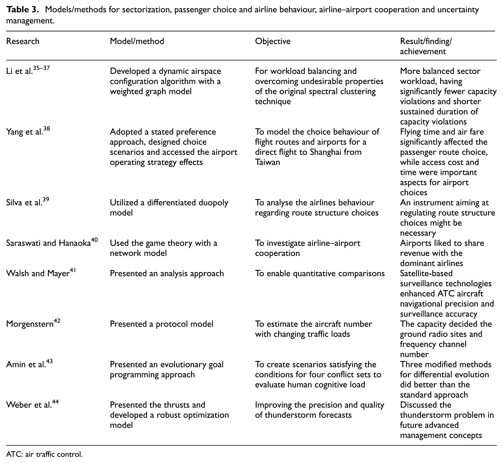
ATC: air traffic control.
Li et al.35–37 developed a dynamic airspace configuration algorithm with a weighted graph model representing the air traffic and air route structure. They formulated the problem as a graph-partitioning problem by bisection of the graph into sub-graphs using a spectral clustering technique to further improve workload balancing and also presented an algorithm to overcome the undesirable properties of the original spectral clustering technique. Sectorization of the airspace was achieved using graph search. The benefits included computationally more efficient, satisfying the minimum distance constraint, and not requiring initial sectorization. Simulation results showed more balanced sector workload, having significantly fewer capacity violations for the worst-case performance as compared to current sectors, and shorter sustained duration of capacity violations. 37
Yang et al. 38 modelled the choice behaviour of flight routes and airports for a direct flight to Shanghai from Taiwan by adopting a stated preference approach, designing choice scenarios and accessing the airport operating strategy effects. They analysed the trade-off among flight attributes, access factors and airport characteristics and found that flying time and air fare significantly affected the passenger route choice, while both access cost and access time were important aspects for airport choices.
Silva et al. 39 analysed the airlines behaviour regarding route structure choices, utilizing a differentiated duopoly model, which considered airline endogenous hub location, passenger connecting costs, traveller benefits from increased flight frequency and congestion externalities. They investigated the route structure configuration and found that an instrument aiming at regulating route structure choices might be necessary, besides per-flight and per-passenger tolls designed to rectify output effects.
Saraswati and Hanaoka 40 investigated airline–airport cooperation in which airlines offered a fixed payment and the airport shared a proportion of its revenue, using the game theory with a network model, which enabled the analyses of the impacts of the cooperation on the operational strategies of the airlines. They observed the revenue share allocation, which maximized the airport profit, and investigated the influences of the revenue sharing on the social welfare and competition. They utilized multi-airline multi-airport non-cooperative games using the network model and found that airports liked to share revenue with the dominant airlines to win the maximized profit.
Walsh and Mayer 41 presented an analysis approach to enable quantitative comparisons, and assessment results of the terminal radar data obtained at key US airports. The satellite-based surveillance technologies enhanced air traffic control (ATC) aircraft navigational precision and surveillance accuracy, which paved the way for decreased separation minima to increase airspace capacity and operational efficiency.
Morgenstern 42 presented a protocol model to estimate the aircraft number with changing traffic loads that a ground station could support. The capacity decided the ground radio sites and frequency channel number that were necessary to support future data communications services.
Amin et al. 43 presented an evolutionary goal programming (GP) approach that created scenarios for the simulations. The evolutionary GP approach targeted to create scenarios satisfying the conditions for four conflict sets to evaluate human cognitive load. Simulation results indicated that three modified methods for differential evolution did better than the standard approach by creating scenarios satisfying the conditions.
Traffic managers would use moderate delaying procedures to reduce the chances for an aircraft to come across thunderstorms along its flight route. Weber et al. 44 proposed the thrusts improving the quality and precision of thunderstorm forecasts, converted the forecasts into estimations of future airspace capacity and developed a robust optimization model based on the estimations. They also discussed the thunderstorm problem in future advanced management concepts.
Besides the topics listed in Table 3, the runway capacity is a popular topic as well, because it is one largest threat facing the expansion plans of airlines. The runway capacity of an airport45,46 is the number of airplane movements that can be safely conducted on the runway as approved by the authorities.2,47 It is reflected as the number of arrivals and departures per hour. 48 The airport capacity is also influenced by the performance of the airlines at that airport. Jenatabadi and Ismail 49 proposed a structural equation method (SEM) to estimate the performance of the airlines. The technique was also employed by Yang et al. 50 and Chiou and Chen 51 about LLCs. Hsu and Liu 52 and Chang 53 investigated the effects of cabin safety on airport capacity. The influences of traffic control on airport capacity were investigated by Kuo et al. 54 More techniques employed to investigate the factors affecting the airport capacity are analysis of variance (ANOVA), 55 time series, 56 regression,57,58 data envelopment analysis, 59 order preference technique, 60 multiple criteria decision making 61 and structural equation 49 modelling. 47 A mathematical probability technique was utilized by Irvine et al. 62 for estimating the capacity of the airports in the South of England and in London. Their study depicted the results of having new runways at various airports and provided ways of increasing capacity using existing runways in a different manner. Pitfield and Jerrard 63 also employed this method for estimating the capacity of Rome Airport and analysing the concept of unconstrained capacity. The advantages of Monte Carlo simulations are flexibility and simplicity 64 via random simulations. 65 Therefore, this method was also adopted in studies of runway capacity in the ASEAN. 47
New developments in the ASEAN region
The ASEAN has decided to form open skies in the ASEAN, although the member states differ largely regarding their aviation policies, strength and size of the aviation industries and GDP per capita. 66 In 2008, the ASEAN member states accepted a Multilateral Agreement on Air Services, which might result in an eventual Single Aviation Market arrangement. 67 With the new open skies policy, it is expected to increase regional and domestic connectivity and thus increase the overall capacity of the ASEAN region. 66
Airlines in the ASEAN region were predicted to have delivery of over 3000 aircraft worth about €500 billion by 2032; Boeing forecasted that the passenger movements within and from this dynamic region would increase by 6.5% annually in the next 20 years and the EU initiated the AATIP (ASEAN Air Transport Integration Project) in 2012. 68 Constructing the regional tourism system 69 would enhance the density of flights and opening up of new routes. How to efficiently increase the aviation capacity is an important issue to promote economy growing sustainably and quickly. 70
Singapore has built its air links, and grown as a hub, connecting its Southeast Asian hinterland to the world via air transport activities. 71 The United States has growing financial ties in Southeast Asia. 72 Studies 73 found competition between China and ASEAN countries declined and integration increased. Air transport is a critical element in the flow of capital and people in the Asia Pacific region. 74
Traditionally, many researches have been conducted in the United States and Europe. Moreover, with the demand for air traffic increasing, the FAA (Federal Aviation Administration) has initiated the NextGen (next generation air transportation system) to upgrade and modernize the ATC system 75 and enhance the capacity of the national airspace. 76 In 2007, the European Commission started the SESAR JU (Single European Sky ATM Research Joint Undertaking) to coordinate all relevant research and development efforts in Europe. 77 SESAR targets to develop the new generation of the European ATM system to ensure fluidity and safety of the air traffic with a high level of efficiency and interoperability for the next several decades. 78
However, until recent years, there was no ASEAN-wide institution that performed research to enhance the capacity and efficiency for the seamless ASEAN airspace from both the operator and airspace user’s perspectives. Therefore, an ASEAN modelling and simulation function has been established by the Air Traffic Management Research Institute (ATMRI) to perform analyses of airspace structures and traffic flows throughout the ASEAN and produce solutions for capacity and efficiency enhancements. Subsequently, the ATMRI can share its experience with the rest of the region. The research subjects include network and local capacity planning, airspace improvement, new route structure and procedures and so on. Full-time researchers and university faculties in the region have also started research projects. Innovative research results may be expected in the context of the ASEAN in the near future.
With the initial task done successfully, ATMRI researchers are able to examine the route structure from its origin to its destination, within and outside the ASEAN. The ASEAN modelling and simulation function has enabled the establishment of the current baseline of traffic demands, 79 which have been processed from the air traffic data provided by the ASEAN Member States. Such analyses have resulted in the determination of the capacity/demand baselines and future demands 80 on the ASEAN ATM system, and modelling and simulation of South China Sea Air Traffic 81 and so on.
Besides the development projects collaborating with EUROCONTROL and various ASEAN Member States, the RACE (Regional Airspace Capacity Enhancement) program in the ATMRI also undertakes basic research. For example, the future air traffic demands in the ASEAN region were forecasted, considering various factors such as GDP, 12 population growth 82 and high-speed train, 83 using various models.84,85 The flight delay caused by bad weather would affect the airport capacity. 86 Visual conspicuity of departing and approaching aircraft was studied by simulations. 87 The airspace load and the relationship between sector size and controller workload 88 were also studied. Recent advances for more efficient air traffic 89 and more efficient airspace in this region 90 were explored. An algorithm based on the A* search technique was presented 91 to avoid prohibited areas, collision 92 and bad weather and to determine the optimal path. Obstacles were randomly distributed, and the algorithm could find the optimal path with the least travelling distance while avoiding prohibited areas and adverse weather. Our study 93 has found that near constant capacity could be close to the maximum capacity when a new route structure was applied. The use of a dedicated flight level with assigned speed during saturation of the air traffic demand would aid in increasing of the capacity in a safe manner.
Phyoe et al. 12 found that the traffic density of Singapore FIR (flight information region) in 2015 was acceptable. The estimated 3D densities of Singapore FIR in 2030 are shown in Figure 1. The colour tones from green to red represent the densities from low to high. Light green represents 5 or fewer flights, green yellow represents 6–10 flights, yellow represents 11–20 flights, orange yellow represents 21–50 flights, blaze orange represents 51–100 flights and red represents 101–200 flights per day for the airway area. The figure depicts a significant increment of density in certain major airway areas. Some junction parts of airways may have 101–200 flight movements per day. Conflicts of 1762 are obtained under the condition of three runways, which are three times the current conflicts. In view of this situation, more efficient capacity planning may be needed in advance.

Estimated 3D densities of Singapore FIR in 2030. 12
The aircraft movement forecasts between country pairs were derived by Raheja et al. 94 using the quantitative method of forecasting. The air traffic forecasts between selected country pairs in the ASEAN are shown in Figure 2. Flights between Malaysia and Singapore will experience the highest aircraft movements from 2016 to 2020 with an average annual growth rate of 9.8%, but the long-term growth will stand at 8% from 2016 to 2030. The expected completion of the high-speed rail between Kuala Lumpur and Singapore by 2026 may hinder the future growth rate of air transport. An average annual growth rate of 6.4% is expected for aircraft movements between Thailand and Singapore from 2016 to 2030. Air traffic between Indonesia and Singapore is forecasted to increase at an average annual growth rate of 6.3% from 2016 to 2030. Flights between Indonesia and Malaysia are forecasted to grow at average annual growth rates of 9% and 7.6% from 2016 to 2020 and from 2016 to 2030, respectively. The flights between Malaysia and Thailand may expect an average annual growth rate of 6.8% from 2016 to 2030.

Forecasts for aircraft movements between country pairs from 2016 to 2030. 94
Existing models might not consider actual flight paths and constraints on segments between waypoints, and waypoint constraints might not be addressed. 95 There is no existing model that can find optimal solutions in reasonable time for large-scale congested airspace that includes all airport capacities, route capacities and controller’s workload. In addition, ground holding and airborne holding costs may differ depending on the airport and airspace where an aircraft is. A model to find optimal routes was proposed by Sailauov and Zhong 95 for the first time for large-scale airspace, like the ASEAN airspace. The model considers all constraints and gives a more realistic optimal solution for congested airspace. The model considers real flight paths, safety issues and controller’s workload, which are not included in other models. The advantages of the new model are the model uses actual routes instead of flown sectors or airports. The model enables more detailed and more accurate representations of routes in real life. The objective function consists of superposition of ground holding and airborne holding delay costs. Linear superposition of the objective function ensures fast calculation of optimal routes. It takes into account differences in ground holding costs in different airports and differences in airborne holding costs in different airspaces. It takes into consideration airport, detailed airspace capacity (fixes and paths capacities) and controller’s capacities. By having the maximum duration of the flight, the ‘fairness’ of the delays is ensured, so that none of the flights gets delayed for a very long time.
Building efficient airspace in the Manila FIR via implementation of the free route concept was studied by Xie et al. 96 Free route structures are simpler and more direct than the current discrete route structure. The workload for the executive controllers and planning controllers has decreased. Especially, the free route concept can reduce the workload of the planning controller by 43.1%. The relief of the air traffic controllers’ workload can contribute to higher safety operation levels of ATC and make traffic controllers be capable of handling more aircraft.
The capacity and cost effects of contingency routes under bad weather conditions were also investigated by Aneeka et al. 97 With a storm block modelled, flight routes N884 and M767 were intersected with the storm block. The outbound flights to Singapore from Manila over M767 would be the most affected by the simulated storm. The inbound flights via N884 would also start descending by the time they reached the boundary of the simulated storm block. The outbound flights via M767 had to be in continuous climb. The research modelled a new contingency route for the outbound flights to Singapore from Manila that usually fly on M767 and investigated the corresponding benefits of cost and capacity variations. The research found that the best possible way to divert the outbound flights to Singapore from Manila would be to allow a new unidirectional route from waypoint REKEL connecting to waypoint TENON. The route should allow the same flight levels that are allotted to the flights over M767. Although this proposed new route intersects with N884, there are no possible conflicts because N884 is unidirectional and has been allotted different flight levels for operations.
Goh et al. 98 found that the amount of conflicts could be significantly affected by the directions of routes. For a selected area, statistically there is no significant difference to the amount of conflicts if we change the number of intersections, contrary to intuition and experience in the ATM field. However, this should not be generalized to every case because the arrangement of the air-traffic-service routes differs in every FIR. The results would be better served as preliminary references for decisions about air route and airspace designs. 98
The tremendously growing air traffic demand brings more needs to reduce green-house-gas emissions from airplanes and air pollution. Figure 3 depicts the original fixed air-traffic-service routes in red and the simulated direct free routes in green. The flights were then simulated to pass through these direct free routes between the selected entry and exit points. Aneeka and Zhong 13 revealed that there might be a great potential decrease of CO2 and NOX emissions with the implementation of free route airspace in the ASEAN. But, the application of the free route airspace concept in complex airspace might decrease the capacity. 99 Our study 13 addressed the problem by exploring the implementations of land-based ADS-B (automatic dependent surveillance-broadcast) coverage over the ASEAN airspace and upgrading to space-based ADS-B in the future.
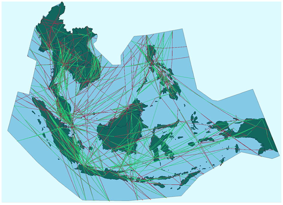
Air-traffic-service routes versus free routes. 13
One challenge for faculties and researchers in universities of this region to start research on air traffic management could be the difficulty to find collaborators in the industry. There are needs for collaborations among the stakeholders in the industry, aviation authorities and academia. As experiments using real aircraft and passengers are difficult, risky and costly (if not impossible), modelling and simulation can be an appropriate approach for academia to start research on air traffic management. When much more research outcomes with more realistic solutions to real-world problems are published, the stakeholders in the industry in this region may be expected to become even more collaborative.
Another challenge is data availability for modelling and simulations. Although a lot of data are available in the United States and Europe, data are not shared openly in this region. Certain member states would insist that their data are always confidential and any open sharing of research results using their data needs permission from them. Therefore, the examples of recent publications and presentations summarized in this section are based on the data collected from the Internet and/or commercial data providers. The annual licence fees for commercial data are expensive. However, the examples in this section of this article also have demonstrated that research and testing of new ideas can be conducted in this region as well. With more collaborations and open-mind from more stakeholders and aviation authorities, data may become less confidential in this region as well and eventually can be openly shared with the public researchers in the future.
Concluding remarks
The aviation industries in the dynamic regions of the world have witnessed exponential demand growths, and the associated possible risks include congestion, delays and dissatisfied passengers. More studies should be conducted to increase the efficiency of air transport operations with the increasing demands. Research on optimal flight paths/routes, more efficient route structures and sectorization is expected to be more intensively conducted especially in the ASEAN region. The ASEAN has decided to form open skies in the ASEAN. It is expected to increase regional and domestic connectivity and thus increase the overall capacity of the ASEAN region. An ASEAN modelling and simulation function has been established to perform analyses of airspace structures and traffic flows throughout the ASEAN and produce solutions for capacity and efficiency enhancements. This review has helped to identify the research gap. The research on air traffic management in the ASEAN region is still lacking. Much more efforts should be made in order to meet the demands of this most dynamic and fast growing aviation market in the world.
Footnotes
Handling Editor: Filippo Berto
Declaration of conflicting interests
The author(s) declared no potential conflicts of interest with respect to the research, authorship, and/or publication of this article.
Funding
The author(s) disclosed receipt of the following financial support for the research, authorship, and/or publication of this article: Part of this research was sponsored by the ATMRI of NTU and CAAS via ATMRI Project No. 2014-D2-ZHONG for Regional Airspace Capacity Enhancement – ASEAN Pilot.