
Abstract
This article aims to historicise the making of the border between the Russian and Ottoman empires in southern Bessarabia, drawn in the post-Crimean War context in 1856–1857. An international commission was appointed for this purpose, and delegates from five empires – Austrian, British, French, Russian and Ottoman – gathered in the province on the ground to demarcate the border decided by Europe's powers. Based on the commission's lengthy protocols, and on the memoirs of several experts involved in surveying, mapping and demarcating the border on the ground, this article delves into the mechanisms of border-making in the field, examining the challenges that commission members encountered with finding a common vocabulary and with balancing larger geopolitical interests with local geographical realities. The case study is also an excellent illustration of what it means to zoom in and out of the different scales involved in bordering. From the diplomatic meetings in Paris to the commissioners’ negotiations in Chișinău and the land surveyors adding names on maps after discussions with peasants in a village close to the Dniester, border making is a complex process that operated simultaneously at different scales, spaces and times.
On 6 January 1857 ambassadors of Europe's heptarchy gathered in Paris to solve several pending issues in the execution of the treaty signed just some nine months earlier. Article 20 of the Paris Peace Treaty, concluded on 30 March 1856 at the end of the Crimean War, had established the general contours of the borderline. This was to separate – in southern Bessarabia or the Budjak (a region now shared by Ukraine and the Republic of Moldova) – the Russian Empire and the Ottoman Empire's vassal principality of Moldavia. The borderline, the treaty stated, ‘shall begin from the Black Sea, one kilometre to the east of the Lake Bourna-Sola, shall run perpendicular to the Ackerman Road, shall follow that road to Trajan's Wall, pass to the south of Bolgrad, ascend the course of River Yalpuck to the Height of Saratsika, and terminate at Katamori on the Prut’. Delegates of signatory states were ‘to fix, in its details, the line of the new border’. 1
This was simpler said than done, and the commissioners who convened in Bessarabia in the summer of 1856 encountered innumerable problems in decoding and enforcing the treaty text. The January 1857 ambassadorial conference was summoned to find a political solution to these disputes, and the ambassadors’ protocol provided a much more detailed description of the new boundary: it started ‘from the Black Sea, 2,936 meters east of Lake Bourna-Sola’ and followed distinctive points marked on a map (see Figure 1) by letters from a to k‴ (triple prime). Two written appendices provided all the geographical landmarks needed to clearly delimitate the boundary and to demarcate it on the ground.
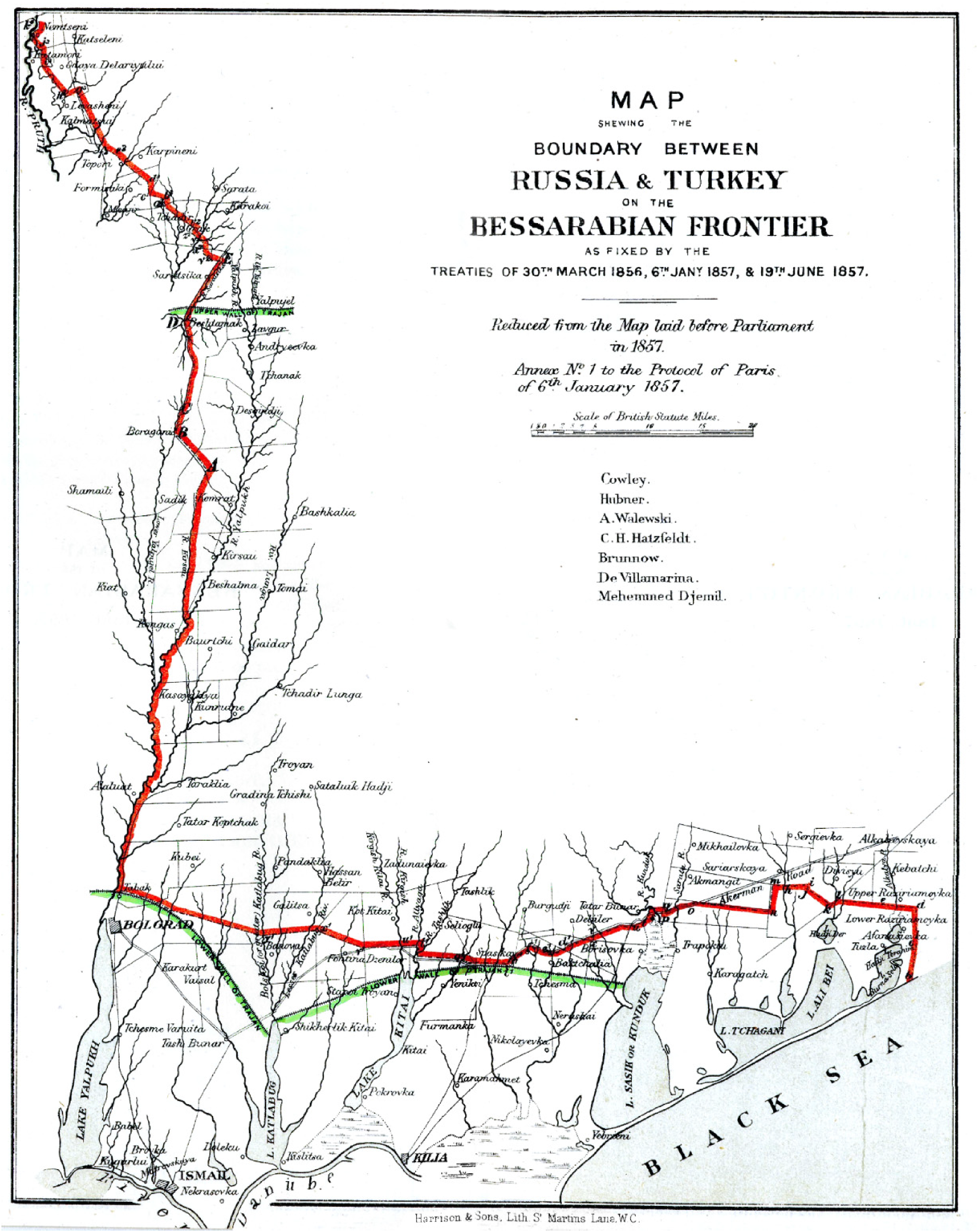
Map of the Bessarabian boundary, 1857.
The difference between the two redactions was the result of busy proceedings by several European commissioners, who surveyed, mapped and bargained in an attempt to reconcile the 1856 treaty's strategic aims with the physical realities on the ground. Historians have produced several interesting works on the larger geopolitical entanglements of the execution of the 1856 Paris Treaty. In detailed treatments of diplomatic history, Harold Temperley 2 and Werner E. Mosse 3 have analysed how territorial issues tested the strength of the Western coalition that defeated Russia in the Crimean War; Romanian historian Dumitru Vitcu 4 has brought some local perspectives on these disputes to the forefront, whereas Moldovan historian Eugen Sclifos 5 has recently published French and Austrian diplomatic documents on the Bessarabian question of 1856–1857. In a recent article, based on British sources and available secondary literature, I have outlined the general context related to the making of the Bessarabian borderline and its geopolitical significance in the aftermath of the Crimean War. 6 In all such analyses of the Great Powers’ politics, the commissioners’ work is usually presented in very general terms and against the background of their states’ larger diplomatic gambles.
There are two levels of decision-making relevant to understanding the establishment of the Bessarabian border: its broader contours were settled by the victors’ top diplomats who had larger geopolitical considerations in mind when making their decision – the main one being to remove Russia from any contact with the Danube River 7 ; the more exact configuration of the boundary was, however, negotiated by the commissioners whom signatory powers sent to Bessarabia to mediate between their governments’ geopolitical aims and the actual geographical and human features of the borderline they were to delimitate and demarcate. The former level is relatively well documented, as mentioned above. This article aims to focus on the latter level, hardly known in the literature, by bringing the border commission to the fore and by detailing its organisational features and decision-making mechanisms. It will further examine, based mainly on the commission's official protocols, the delegates’ proceedings, as well as evaluating their agency and reliance on expertise to produce knowledge and to use it in order to bolster an agreement beneficial for their states’ interests, but also for the human communities in the Bessarabian borderland. I will follow a chronological-thematic approach, with some introduction on the commissioners and their instructions, followed by references to the commission's formation and organisation, the preliminary works done on the ground, disputes and resolution mechanisms, the demarcation of the borderline and its confirmation by the Great Powers’ ambassadors. In all these instances, the commissioners and their staff drew a border that they actually rode along, drove along and walked along – a path off the beaten track for nineteenth-century diplomats and current historians alike. It was such geographical knowledge mapped in small villages in one of Europe's least-known peripheries that would eventually compel the Great Powers’ diplomats – gathered in what was the continent's most influential political centre – to update the peace treaty signed in 1856.
By mid-May 1856 the commissioners of five European empires met in Moldavia's Danubian port-city of Galați, instructed by their governments to fix, ‘in its details’, the borderline that was to separate the Russian and Ottoman empires in Bessarabia. Austria, France and Great Britain entrusted their interests to officers with surveying and engineering expertise (Antoine Kalik, Pierre Marc Besson and Edward Stanton, respectively), while the more directly involved powers appointed two delegates each: General-Major Michel Fanton de Verrayon 8 and Colonel Alexander, Baron de Stackelberg on behalf of Russia, and Major-General Dervish Pasha and Brigadier General Prince Grigore Sturdza (Muhlis Pasha in the Ottoman military ranks) for the Sublime Porte. 9
The main negotiators, Verrayon and Dervish Pasha, were familiar with the Lower Danubian region. The former, a French emigrée who made a career in the Russian army, had been deployed to the Danubian principalities during Russia's military occupation of the principalities (1828–1834); Verrayon had a Wallachian wife, a member of an influential noble family in the country, and was well aware of local politics, 10 a fact that would secure his appointment as Governor of Bessarabia later in 1857. Dervish Pasha, governor of the military schools in the Ottoman capital, had been delegated by the Porte to serve on several missions to the Danubian principalities, such as in 1848 or 1854. Both had the expert knowledge needed when drawing a border, but their appointment had much to do with their negotiation skills and knowledge of the specifics of working in their empires’ peripheries.
Sturdza's choice was also politically motivated, and the Russians initially objected to his appointment. 11 As a Moldavian subject and the son of a former hospodar, Sturdza used his position not only to defend his principality's interests, but also as a springboard towards getting nominated to Moldavia's throne, which was vacant at that time. Sturdza's attitude and his constant ‘sparring with the Russians’, and to the exasperation of most of the other delegates, hampered the commission's works on several occasions. 12 With further delays brought about by governmental disputes and with Dervish Pasha back to Istanbul by late 1856, it was eventually Sturdza who concluded the final agreement on behalf of the Ottoman Empire.
The commissioners received clear instructions from their governments as to their mission. Austria's Kalik was to follow the treaty text as closely as possible; where slight departures from it were needed, adequate territorial compensation had to be found. 13 Stanton was equally directed to follow the treaty text and stay in touch with the Foreign Office regarding any significant deviations from it, 14 while Besson was ordered to complete his mission as expediently as possible. 15 The Russians aimed to prevent, as much as they were able to do so, the division of communal properties, 16 whereas the Ottomans wanted to ‘correct’ the treaty line and obtain ‘a line of defence and the means of protecting the two countries [Moldavia and Wallachia] from an unforeseen invasion’. The Ottoman commissioners thus eyed several strategic sites, which they hoped to acquire with assistance from allied powers. 17
But the Ottoman commissioners failed to mobilise allied support for this. Besson, Kalik and Stanton (a trio I will term the ‘allied commissioners’) were instructed to stick to the treaty text and ‘to adhere as closely as possible to that line, without contending for so-called strategical advantages’ beyond what was mentioned in the peace treaty. The three allied commissioners were instructed to focus on their role as negotiators ‘for arriving at an unbiased and impartial settlement’, 18 regarded as vital for Europe's balance and peace. Even beyond their governments’ instructions, the trio acted generally as honest brokers who aimed to find a workable solution for their states’ interests, but also for the benefit of the human communities affected by the border change.
Some references to the communication infrastructure available in the region are important for better understanding the context in which the commission worked and the scope of the commissioners’ agency in the delimitation and demarcation of the boundary. Telegraph lines were available in Moldavia (in Galați and Iași), and they proved crucial for rapid exchanges with governments, although crossing the Prut River from Bessarabia into Moldavia was sometimes difficult (on account of, among other things, quarantine restrictions). Odessa was a major communication relay with the wider world, but the Russian postal system was hardly reliable, and Stanton reported problems with getting his mail. At one time, ‘the dispatches intended for Colonel Kalick […] were inclosed in the envelope to my address, whilst those intended for me were inclosed to Colonel Kalick's address’. At the same time, Besson's dispatches ‘passed the quarantine without being opened’. 19 Stanton would use British couriers whenever possible, which was oftentimes inconvenient given the relatively bad transportation infrastructure of Bessarabia, especially in rainy days or in wintertime. Sometimes the allied commissioners cooperated for quicker and more reliable communication, such as when Stanton and Kalik banded together to send a messenger to Galați. 20 The Russian commissioners held, via Odessa, a clear advantage in communicating with their cabinet, a time and information edge that they used in order to advance their interests and enlarge the cracks gradually forming in the solidity of the British-French alliance.
With Russia interested in delaying an agreement, and with the completion of the border demarcation set as a condition for the evacuation of the Austrian troops which occupied the Danubian principalities, governments had to allow their commissioners some more bargaining flexibility. This would result in a simplification of voting procedures, in accepting slight deviations from the treaty line and in establishing a framework for concessions needed to bring the commission's task to an end.
Institutionalizing the commission
The commission held three organisational meetings in Galați (on 1st, 2nd and 4th June) and established preliminary rules for its proceedings before heading out to examine the actual borderland they were to divide. Protocols were to be drafted by a Russian secretary, while majority voting was proposed to solve disputed issues. 21 Russia rejected this proposal, and all cases in which commissioners could not reach a unanimous agreement were to be discussed and resolved by governments. 22
Another important issue concerned deviations from the borderline that were mentioned in the treaty text. Besson was authorised to accept slight changes within the delimitation league to prevent the parcelling out of properties. Eventually, the commission agreed to accept deviations meant to reduce the number of mixed properties and to render the borderline functional for local communities. When further discussing the choice between natural boundaries or the administrative limits of communes, the Russians claimed they wanted to keep private properties intact whenever possible, whereas the other commissioners privileged natural boundaries, in view of their superior military and administrative function. 23
Russia's commissioners equally proposed to establish a strip of neutral ground along the entire borderline, a bordering practice that was allegedly used on the empire's land frontiers with Austria and Prussia. The proposal was rejected, as it would have involved complicated expropriation and compensation litigations. 24
After examining in Galați the topographical maps of Bessarabia, the commissioners made plans for conducting the fieldwork to collect the information needed to fix, in its details, the borderline. They agreed to undertake reconnaissance, ‘maps and plans in hand’, along the proposed borderline. The commissioners would inspect an area of 10 km on each side of the line, so as to find suitable compensation for any necessary deviation. The Russian commissioners were to provide the topographical plans of those regions; should doubts exist as to their accuracy, the plans were to be checked by an instrument in the commissioners’ presence. Once the borderline was established, Russian topographical officers would survey it in conjunction with experts from the other powers, by means ‘of a single graduated instrument, and a single alidade board, on which board the figure of the ground shall be determined instrumentally, one kilometre to the right and left of the frontier line, on a scale of 1/21,000, the scale of the Russian topographical plans’ serving for the commission's works’. 25 The commissioners also agreed on procedures for completing the official delimitation map, as well as all required written documents, in the form of a journal or cahier de spécifications, a record of all points, angles and distances indicated on the official delimitation map. All documents were to be confirmed by an ad hoc act of the commission, which, however, was also to conclude a convention on the general directions of the borderline after its inspection on the ground. 26
All in all, roughly three weeks after their initial meeting in Galați, the commissioners had managed to institutionalise the commission and to decide on the organisation of their work. From this point on, they understood that intensive and complex cartographical, technical, but also bureaucratic work was needed to turn the rough contours of Europe's top diplomats into a functional inter-imperial boundary.
When the Paris Treaty did not agree with cartographical reality
The commissioners left Galați on 8th June and proceeded to Bolgrad (now Bolhrad, Ukraine), some 70 km away. Preliminary analysis and reconnaissance had shown that Bolgrad was to be the main bone of contention, given that a considerable difference existed between its actual geographical location and the town's position on some maps (see Figure 2). As Besson simply put it, the Paris Treaty did not agree with cartographical reality. 27
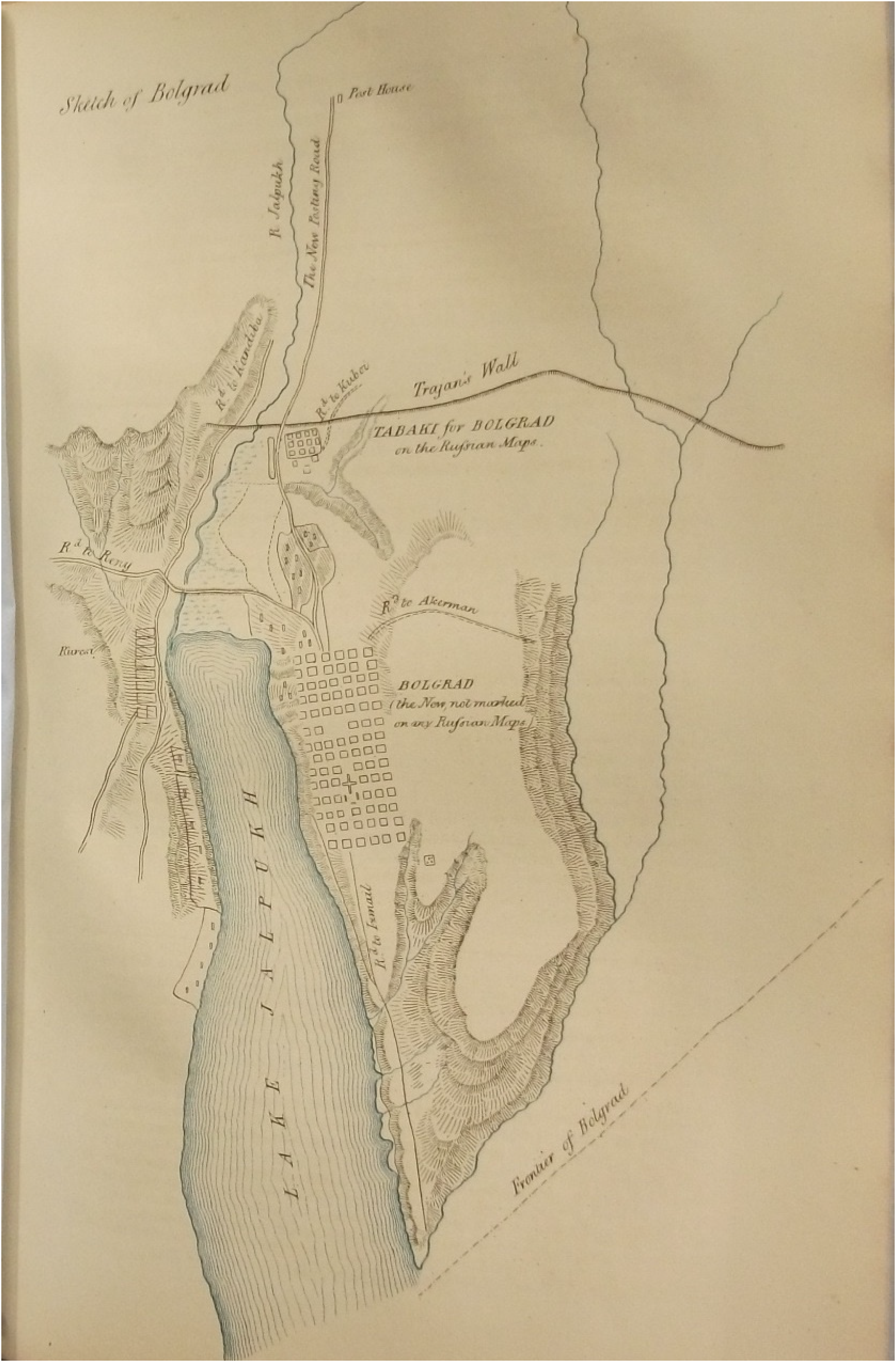
Sketch of the contested Bolgrad region.
When the allied commissioners inspected the area, they realised that the maps used by the framers of the 1856 Peace Treaty had been mistaken and misinterpreted. 28 According to decisions taken in Paris, the new border was to follow a line south of Bolgrad, which Russia was to keep. But Bolgrad lay by Lake Ialpuh (spelled Ialpug in Romanian), in a position that could hardly leave room for a boundary south of it. After inquiries were made among local inhabitants, the commissioners found a second locality, Tabac/Tabak, which had been previously called Bolgrad, and which better corresponded with the position of the ‘Bolgrad’ shown on the Paris map. 29
The commissioners submitted a note to their Russian counterparts, trying to determine ‘whether the said village of Tabac was not the original Bolgrad’ referred to in the Peace Treaty. 30 The Russians replied with a rich historical account of the issue, but insisted that for them there was only one Bolgrad: that which was placed on Lake Ialpuh and had been recognised, since its establishment in 1820–1821, as ‘chief town of the Bulgarian colonies in Bessarabia, residence of the Colonial Administration, possessing a cathedral, schools, and other public institutions’. 31 Russia was determined to keep this Bolgrad, so the border south of the town had to cut across the lake. 32
To the allied commissioners, Tabac was the ‘real Bolgrad’ that the framers of the Paris Peace Treaty had in mind when they described the contours of the borderline. The strategic purpose of the entire border revision – to remove Russia from contact with the Danube River – would have precluded any settlement in which the Russian Empire remained riparian to lakes ‘which are in direct and indirect communication’ with the Danube. 33 As Stanton reported, Russia could accommodate a maritime station on the lake with the seeds of a ‘small flotilla’. Moreover, a boundary across the lake would greatly hamper communication within the different territories that were returned to Moldavia. 34
The allied commissioners tried to find a workable solution to this complicated issue. Their proposal was to have a road built, south of Bolgrad, between the border and the lake. As the road would separate the inhabitants of Bolgrad from the lake, a certain number of designated crossings offering passage for Bolgrad citizens across the road could be kept allowing them to water their cattle in the lake. Another solution was to allow inhabitants to carry out the necessary works to bring the lake's waters into reservoirs dug along this part of the frontier. 35 The commissioners also examined the town's water supply, concluding that Bolgrad had enough options if cut off from the lake. 36
It soon became clear that the issue was too complex for the commissioners to solve and the distinction between the ‘old’, ‘primitive’ or ‘treaty Bolgrad’ (Tabac) and the ‘new Bolgrad’ would keep governments blocked for the coming months until European ambassadors reconvened in conference in Paris, in early 1857.
In expectation of the governments’ instructions on the Bolgrad question, the commissioners started inspecting the borderline, reaching the Prut River by late June and the Black Sea by mid-July. Charles Gordon, one of Stanton's two officer adjutants, who gained world fame in his later life as ‘Chinese Gordon’ or ‘the hero of Khartoum’, described the commission's daily proceedings during this reconnoitring phase: ‘We usually start at four in the morning, and get the journey over by the beginning of the hot part of the day. […] We have now been over the whole of the frontier, from Katomori on the Pruth, to Borna Sola on the Black Sea, a distance of very nearly 200 miles. It is an odd sort of life, going about twenty miles per diem, and camping for the day about ten o'clock’. 37
Two more issues emerged during the commission's fieldwork: one related to fixing the border along the Ialpuh River, the other to bordering Lake Bourna-Sola. In the first case, the problem resulted, once again, from differences between the treaty text, the map used in Paris and geographical realities on the ground. The borderline was to follow the course of the Ialpuh River, which however had two main riverbeds, with allegedly two different names (Ialpuh and Ialpugel, or Little Ialpug). As reported by Stanton, the branch of the river shown on the Paris map as being the main stream was ‘not so, but […] the valley to the west of it is more pronounced and contains more water’. 38 The Russian commissioners, again, alluded to both the orthography on their maps and to the knowledge of native guides employed in the reconnaissance. 39 The Ialpuh issue was also sent to governments, which were to decide which of the two riverbeds was to serve as the border.
The second dispute was that regarding Lake Bourna-Sola. The Russians considered that the body of water named Bourna-Sola on the Paris map was in fact a series of three lakes, the southern one only bearing that name. The allied commissioners, however, did not admit the existence of three separate lakes. 40 Geographically, they claimed, there was only one lake divided artificially to facilitate the exploitation of salt. Eventually, an agreement was made, and the Russians ceded the entire lake to Moldavia for an equal amount of territory on another portion of the borderline. 41
The commissioners’ agency in settling the borderline is clearly visible in Stanton's reports: the border did not follow the Akkerman [now Bílhorod-Dnistróvskyy in Ukraine] road, as directed by governments, but instead was in many cases traced along or around the limits of different communal properties. This had been strongly advocated by the Austrian, French and Russian commissioners, and Stanton agreed to them, despite his government's instructions. His arguments, as explained to the British government, were clear: First, because by so doing we should be enabled to commence the demarcation on the ground earlier than if the questions had to be referred to our Governments; Secondly, because the line proposed did not appear to me to offer any disadvantages that were not compensated by the diminished number of mixed properties; and, thirdly, because the compensation for the portion of territory taken from the Russians at Bourna-Sola could be more easily arranged by following this method than if the Ackerman road was strictly followed.
42
To avoid delays, while awaiting their governments’ responses on the issues mentioned above, the commissioners started drafting the convention describing those portions of the borderline that afforded no problems. They also planned to proceed with the actual demarcation of those sections. 43 The commission remained in Akkerman for the entire summer and worked on drafting the convention. Negotiations proved difficult, and Besson complained about the permanent sparring between the Russian and the Ottoman delegates: ‘They bicker about nonsense, and the cabinets give contradictory instructions’, Besson wrote on 21st July. On 2nd August, again: the commission ‘does not work. The Russians and Turks are as unreasonable as each other, with Sturdza being the greatest nuisance’. 44
Eventually, a new protocol was concluded on 13th August. It included three annexes (two tables and a map) describing and showing the border variants proposed to resolve the Bolgrad and Ialpuh questions. The protocol was turned into a border convention, signed by the commissioners on 24 August 1856. Stanton underlined one of its main principles: ‘We have endeavoured, in drawing up this Convention, to secure to the inhabitants on both sides of the frontier, as much as possible, the advantages they had before enjoyed with respect to the use of water retained by the dykes now in existence’. 45 The ‘best natural line’ was followed wherever possible, and the commissioners strove to ensure that it affected as little as possible transportation infrastructures or the integrity of private properties. Thus, whenever the frontier ran along parts of the Akkerman road, the demarcation line was to be drawn three sajenes (6.40 m) 46 north or south of the road's ditches, ‘in order to preserve the use of the various parts of the road for the state to which they belong, and to allow their future repair, as well as that of the bridges, dykes, etc. which are located on these parts of the road’. 47
To speed up the fixing of the borderline, the commissioners worked out all the possible solutions that governments could reach in the pending issues. This shows that, as the editors discuss in their introductory essay to this special issue, the commissioners’ expertise in the field was able ‘to influence, even reshape, the outcomes of diplomatic agreements’. Initially, the commissioners made calculations for eight possible cases, a combination of three issues (Bolgrad, Ialpuh and Bourna-Sola), which they reduced to four cases when Russia agreed to leave the entire Bourna-Sola Lake to Moldavia in exchange for compensation elsewhere along the boundary. These four cases were indicated on a single map and described in two synoptic tables. Calculations were made on zoomed-in survey plans (at a scale of 1:2,000), and a map at a scale of 1:210,000 was produced, so as to have the entire borderline on a single sheet. Table A included the calculation of land compensation Moldavia and imperial Russia would get in each of the four cases, with reference to the fixed points indicated on the map. 48 Table B provided detailed descriptions of the proposed lines: thus section b, c, dʹ was a ‘line east of Lake Bourna-Sola, slightly broken at c, and crossing the property of Mr. Aphanassieff; b is situated 2 versts 49 and 376 sazhen east of the south-eastern tip of the lake’; section ‘h, m’ was ‘the boundary between the property of Mr Mikhailouka to the north and Mr Marazly to the south’, whereas section ‘m, n’ was the ‘boundary between the commune of Akmanghit to the west and the Mr Marazly's property to the east’. 50
The protocol and its three annexes (the map and two tables), signed by all the commissioners in five copies, were unanimously declared to constitute the preliminary convention, pending confirmation of the accuracy of the plans that the commissioners had used. 51 With this, the boundary was delimitated for three-quarters of its total length. The rest depended on a political agreement among the signatory powers of the 1856 Paris Peace Treaty.
Shaping the borderline on the ground
Relations between the French and British commissioners had been generally good. Besson, Stanton and the latter's staff ate together, taking advantage of the cooking abilities of Besson's soldier servant. 52 The commissioners were given good quarters in villages along the borderline and later in Bessarabia's capital of Chișinău, but the attitude of local Russian authorities towards the commission was rather ‘antipathetic’. As Gordon reported, ‘the commissioners went to one public dinner, and that has been all’. 53 Besson did enjoy more attention from the Russians, at a time when France and Russia were inching closer towards a diplomatic rapprochement, following Napoleon III's new political gambles in Eastern Europe. 54
In October, the commissioners also visited Iași, Moldavia's capital, where Sturdza served as a more entertaining host for Europe's delegates. With much time available while the group was waiting for governmental instructions, hunting was the preferred social activity of the allied commissioners. Both of Stanton's adjutants mention a ‘wolf excursion’ in which the British party was accompanied by Besson, Sturdza and several Russian subjects. 55
Some further problems emerged in the autumn months, when the British and French governments made clear their opposing views on the pending issues in the execution of the treaty. Both cabinets used the reports sent by their commissioners to argue for the geopolitical value (or lack thereof) of Bolgrad. The Foreign Office instructed Stanton to induce Besson to take ‘the same view as you do about Bolgrad’, 56 and pledged the Austrian cabinet to send similar orders to Kalik. 57
Beyond his country's oscillating interests, Besson had been the main broker still trying to find a workable compromise in the Bolgrad dispute. 58 But the Russians rejected Besson's proposal and insisted on preserving Bolgrad. New disputes followed in relation to the political and socio-economic status of the Bulgarian colonies, whose well-being Russia's commissioners claimed to have in mind. 59 On 3rd October, the French government disavowed Besson's latest proposals and instructed him to strictly follow the treaty text, which left Bolgrad in Russian territory. 60 The move was regarded as part of Russia's machinations to break the British-French alliance, and Gordon also mentioned the rumour that the Russians aimed to have Besson replaced, ‘as they do not like the way he treats them’. 61 Besson's censure by his own cabinet put a stop to any further attempts to reach an agreement in the commission, and the delegates had to wait for their governments to reach a political solution.
Meanwhile, from 1st September the commission started demarcating the border on the ground, with two Russian regiments tasked and paid by the two neighbouring states to execute the various earth-works necessary for marking the frontier. 62 Progress was fast, and by 5th October the boundary was demarcated along the sections on which an agreement existed. 63
Demarcation came with clear rules regarding the maintenance of the physical markers of the boundary (truncated cones of earth, prism-shaped stones, and a ditch along the dry border and clearings in the woods) and with cohabitation rules for the neighbouring communes on the two sides of the new borderline. Along the Ialpuh borderline, the inhabitants of both banks retained the right to use the waters in common, and for maintaining the dikes bordering municipalities paid in proportion to the number of inhabitants using those water resources. It was forbidden to carry out any works which could bring about changes in the thalweg that had been plotted and recognised as such during the commission's survey. 64
In October 1856, the commission headed to Chișinău and, in expectation of a political solution to the two pending territorial issues, worked to complete the maps and the other necessary paperwork. Lieutenant James, the second of Stanton's adjutants, noted that they were busily engaged in the commission's works: ‘The plans to be drawn were about thirty-five in number, large and small, and Gordon and I between us made them in triplicate, so that in fact we drew more than a hundred in six months’. 65
In January 1857, the Great Powers’ ambassadors concluded a protocol in Paris, based on the commission's proposals in their August convention. The agreement was mediated by Napoleon III, who left both Bolgrads to Moldavia, but granted Russia the town of Comrat in the Ialpuh region and a colony of about 8,000 Bulgarians. 66 Following this political decision, the commission could finally conclude its works, with 30th March, one year after the signing of the Paris Peace Treaty, set as a deadline. It was an intense period for the commissioners and their staff, with both cartographic work and demarcation processes progressing in parallel. For Gordon, in charge of drawing plans and maps for the British delegation and also for Besson, it was a real headache: ‘For my part, I have had enough of them for my whole life’. 67 Demarcation in winter, with works in the frozen ground, was even more troublesome.
Eventually, everything was completed on time, and the final act of fixing the Bessarabian borderline was signed in Chișinău on 30 March 1857. 68 Two days later, Besson, Stanton and Sturdza handed the Moldavian authorities a copy of the document. 69 Moldavia received a territory of about 10,000 km2 with a population of circa 140,000 inhabitants, about a third of whom were Bulgarians. Their privileges were recognised by Moldavia, but they were a foreign element which proved rather difficult to integrate in the young nation-state. Problems, allegedly stoked by Russia, would soon emerge. 70
Bessarabian territory brought with it other problems. The Russian government had used its carefully induced delays to sell state property to private citizens, such as those belonging to the Danubian Cossack Army, which served as the border guard along the empire's former frontier. Public land was sold for relatively modest prices, and Sturdza protested vehemently at practices that deprived the Moldavian state of its due properties. The Sublime Porte stated that such illegal sales would not be recognised, and it took many years to clarify the juridical status of the lands that Moldavia received in 1857. 71
On 19 June 1857, a new ambassadorial conference in Paris confirmed all territorial changes in the Lower Danube region in an update to the 1856 Paris Peace Treaty. 72 It was the end of a complicated process that involved decisions taken equally in Paris, the centre of European politics at the time, and in the Bessarabian periphery.
Conclusions
The case of the international commission for fixing the Bessarabian borderline is interesting from several perspectives. It included members from five imperial powers. They negotiated the delimitation and demarcation of a borderland that was little known beyond imperial Russia, which had managed, in the four decades since Bessarabia had been annexed in 1812, to survey the region and to produce relatively decent military maps. 73 Most of the commissioners were experts in surveying, and their expertise (and that of their staff) was decisive in settling the course of the boundary, which corresponded both to their states’ interests, and also to the needs of the communities inhabiting the region.
The commission, however, was as much a gathering of experts as a venue for the playing out of political disputes. Acting in the Russophobic environment of the post-Crimean War context, the commission was dominated by the three allied commissioners, who made sure that the strategic aims of the Paris Peace Treaty were fulfilled, while also trying to make sure that their border-drawing did not create additional problems for the communities that were the ‘victims’ of Europe's geopolitical rearrangements. Besson's mission was further complicated by his government's political realignment, although the French commissioner generally acted as an ‘honest broker’. However, as he wrote in a letter when leaving Bessarabia in April 1857, he had ‘to fight in Chișinău almost as hard as in Crimea’. 74
The workings of the commission clearly show the importance of cartography and the power of maps. The Bessarabian dispute started because of the flaws of the map used in Paris by Europe's victors, which was insufficiently detailed and outdated. The problem was eventually solved with more and better map making. Based on Russian military plans, the commissioners produced maps that were sufficient, in terms of scale and detail, to allow their governments to make an informed update to the 1856 Paris Peace Treaty. These maps were produced while riding, walking or driving along the proposed boundary, while interviews with local people clarified issues with the borderland's topography and hydrography. With such knowledge from the periphery, they were able to provide functional solutions to Europe's heptarchy for fixing the boundary in some contested sites, in the form of detailed compensation tables. The commission produced not one borderline, but four possible borderlines, thus speeding up their governments’ decision and completion of a process that proved to be more complicated than governments had believed.
Not least, the case study of the Bessarabian border commission is an excellent illustration of what it means to zoom in and out of the different scales involved in bordering. From the diplomatic meetings in Paris to the commissioners’ negotiations in Chișinău and the land surveyors’ adding of names to maps after discussions with peasants in a village close to Akkerman on the Dniester, this study demonstrates that border making is a complex process that operated simultaneously at different scales, spaces and times.
As has been stated, ‘the actual act of mapping had a performative power, since it did not merely reproduce what was real’, but also had the capacity to create new political realities. 75 The cartography ‘on the ground’ of 1856–1857 created new realities that would prove relevant for the fate of the region in coming decades, first when the region was reannexed by imperial Russia in 1878, and later in the subsequent division of Bessarabia by the Soviet leadership during and in the aftermath of World War II. 76
Footnotes
Funding
The author(s) disclosed receipt of the following financial support for the research, authorship, and/or publication of this article: This work was partially supported by the Leibniz Association Project ‘Contested Waterway. Governance and Ecology on the Lower Danube, 1800-2018’ (no. K237/2019), hosted by IOS Regensburg and GWZO Leipzig (grant number K237/2019).