
Abstract
A key factor in successful military operations is proper reconnaissance of the theater of operations, which includes mapping transport infrastructures to ensure the accurate location of materials, troops, and supplies. The aim of this research is to facilitate the success of logistical reconnaissance using unmanned aerial vehicles to be able to get more accurate information of the state of transport infrastructure. Rail transportation is well suited to carry out this experiment. As a result of an empirical research, an extended visual checklist is defined, which can be used as a basis for investigating the parameters of the elements of the railway infrastructure, including operation possibilities. The elements of the list have been examined by drones and their effectiveness has also been verified. The three-dimensional (3D) model could be created based on the drone-records, provides information on the condition of the tracks and their surroundings. The drawn conclusions will be used to define general requirements for the use of unmanned aerial vehicles for logistical reconnaissance. The application of the presented methodology can significantly improve the effectiveness of military logistical reconnaissance.
Keywords
1. Introduction
It is an important aspect at military operations, which the use of military forces and devices should fulfill to take account predefined requirements. Thus, the different groups of military organizations will make a plan before commencing operations. The plan can help to execute the missions successfully. At the planning and organizing of operations, the availability of information about the assessment of the battlefield is of an upmost importance. The data about the opponent’s power, abilities, political situation, economical situation or factors influencing logistical support (like the transport network) can contribute to the decision-making of the commander’s staff, because these information could have an effect on the volume of applicable forces, the quantity and the use of resources, and their optimal distribution as well. However, having information about the description about the battlefield’s environment is of upmost importance for the staff conducting operations management to help the commander in decision-making effectively. The responsibility of the organizations making reconnaissance is the planning, the organizing, the coordination of the information collection, and the punctual delivery of information coming from reconnaissance.
At the modern operations management the geoinformation is extended also with the time, which is has become the most important factor in the modern militaries and their operations. 1 The fields where the geoinformatics systems ensuring rapidity are inter alia the logistic support and the transport. For the optimal use of the system, the information describing objects are required (for example, technical information).
The initial information needed for planning, organizing, and for the use of geoinformatics systems are ensured normally through the execution of logistics reconnaissance. The processes collecting information of this subheading are including the assessment of transport networks, the determination of locations of the supply sources, their approach, the estimation of capacities of logistical installations, bases, and objects, which are imperative for the organizations concerned for the successful development and the effective operation of an operational supply chain.
The logistic reconnaissance plays an important role in the preparation of military operations, and in the successful planning and organization of logistical support. Planning of the military operation and achieving the objectives can become more challenging without logistical reconnaissance. It is necessary to have information about transportation infrastructures in order to designate the marching and the supply routes, because they can significantly determine the success conducting of transportation tasks, thereby influence the overall success of the military operation. Data of the transportation infrastructure is an important factor because it can determine the method, the direction, and the feasibility of deployments.
Reconnaissance tasks related to the geographical environment are also importance, when the preparation is conducted for the military operation—especially outside the national borders—(when limited data are available about the theater), because it may occur that rail and road networks, seaports, or airports may not be used or only to a limited extent due to topography, soil, and weather conditions during different periods.
For these reasons, it can be stated that it has to pay a special attention for reconnaissance, gathering, updating, and continuously reviewing of the theater transportation data when the preparation, planning, and organization of military operations, especially logistical support tasks are conducted by forces.
It is worthwhile to use means which can assist with the fast and precise execution of site survey of transportation infrastructure when information that is important for the planning of the logistic support is gathered.
In our opinion, the use of unmanned aerial vehicles (UAVs) is the one of these options. The parameters of railways can be identified based on the image and video recordings made by UAVs, and the data can be transmitted to home bases in real-time for processing and evaluation, thereby may speed up the reconnaissance process. This is in contrast to that method when the site survey would only be conducted by filling out a checklist and subsequently forwarding it. Moreover, by using UAVs, it is not necessary for transportation experts to be on-site to gather and evaluate data. It is sufficient to create 3D image and video recordings based on the inspection checklist with UAVs and then transmit them to the relevant organizations.
The transport system contributes to the military defense of a country. Meeting the movement and transport needs of the army is a primary aspect of the defense strategy of a country, and the security of the transport system is a prerequisite for this. It is why one of the key issues in military operations is the mapping of defense (and deployment) lines. Transport systems are capable of performing both defense and deployment logistics functions, and therefore mapping them is one of the first logistical tasks in an operation. The characteristics of rail transport make it an excellent means of performing military transport and movement tasks, thus contributing to the success of the operation. Regarding rail transport, the NATO Transport Doctrine stresses that it is particularly suited to the (combined) transport of materials and personnel, and it is therefore necessary to have the appropriate capacity (track, vehicles, personnel). 2
One of the objectives of logistics reconnaissance should therefore be to assess the state of the rail infrastructure. Accordingly, the aim of this research is to investigate the logistic reconnaissance of transport and, within that, rail systems by introducing new methods.
The reconnaissance is more than just the sum of processes collecting information. It includes the processing of the collected information, their analysis, assessment, and the delivery of the results coming from these processes for the appropriate organizations and commanders. The main purpose of the reconnaissance is:
supporting the commander;
helping the defining, identifying, and highlighting purposes;
providing defense against the enemy’s deception through planning and execution;
supporting the successful operations and reorganizations depending on the occurred changes. 3
Basically, logistics reconnaissance can be executed through two methods: One of them is the site reconnaissance, when the groups and forces dedicated for the task operate to the battlefield and do preliminary assessment about the available supply, operational, placement resources, and transport networks. The other method is, that the forces gather the necessary information with info-communication devices and convert them to usable data. Regarding both methods, our experiences show that the leaders rather prefer the site reconnaissance than the use of modern informatic and audiovisual devices. They are used mostly as an additional information-verifying method than primary resources. 4
It can be also said about the logistics reconnaissance, that although the timeframe could have an affect onto the task fulfillment and the range of the information to be collected. However, there are key information special attention should be devoted. These are the following:
the information about the supply sources, alternatives of their approach and transfer;
the place of logistical installations and objects, their approach, the possible storage of military implements, data on storage buildings, hangars, and warehouse bases;
information regarding the capacity of areas, workplaces, duty stations, and public facilities enabling disposition of forces;
information about facilities for storage and operation of military equipment: premises, workshops;
the capacities of transport networks, capacity data of subsectors and their condition: parade routes, supply routes, transport nodes, terminals, loading and unloading stations, facilities for handling and stowage;
measuring the services included in host nation support;
outer factors influencing logistic support;
components ensuring the sustainability of the supply continuity. 5
The American Navy, regarding reconnaissance operations, bounds the reconnaissance of transport facilities with the reconnaissance of advance routes, which normally precedes the mobility of friendly forces and happens alongside of a marching route, like route, railway, or waterway. The reconnaissance of the route provides new or refreshed information about the environment and the surrounding terrain of the route and the activities influencing the mobility. 6
On the basis of the above, the assessment of the transport networks is one of the most important tasks at the logistics reconnaissance of the battlefield. The main information of the route and railway networks (for example, the network density of the examined field), and the information about the capacity of airports and seaports provide effective help for the planning of the march, installation, and re-allocation of groups. This emphasizes that the logistical organizations of groups at indoctrination and setting—when the forces operate from the garrison to the shooting range and training area—always handle the reconnaissance of transport subsectors as a task has to be performed separately.
Granted to the size and the extended infrastructure of transport networks, it is worth examining the—sometimes sector-specific—methods applicable during the logistics reconnaissance. This article deals with the railway sector, because this subsector can help the execution of military delivery tasks on land significantly, inasmuch as being capable of fast delivery of heavy loads and significant quantity of human resources for long distances. The prevailing capability of use of rail infrastructures is important especially for the military of defense, because the requirements of the strategic-operational mobility are secured by them in specific legislative period. The successful execution of national defense tasks depends on how the subsector can be used for the quick deployment and redeployment of forces, and the delivery of supplies. That is why the rail infrastructure is well situated to examine the effectiveness of drones in logistic reconnaissance.
The UAVs ensure flexibility and adaptability for the wide range of military applications, so the reconnaissance tasks. The combination of developed navigation and communication systems enables the wide range of use of drones in military use. 7 Romanian researchers have said in their previous article in 2010 that the reconnaissance of transport nodes with drones is possible. 8
In our article, the solution of visual inspection of the railway traffic system is discussed. The railway was of upmost importance in military mobility and as Wiktor Biernikowicz states in his manuscript, it will still be, 9 so it is worth doing the examination for this transport subsector. The mapping of the railway infrastructure and the consideration of its parameters contributes largely to the reconnaissance of the battlefield with for example the velocity and the loading of the trains traveling on the infrastructure. 10
So, first of all we determine the aspects for the successful execution of the logistics reconnaissance and the collection of information as an extended visual checklist. In the second part of the article, we show the results of our experiments with drones based on the checklist and make consequences about the applicability of drones in the reconnaissance of the railway networks.
2. Logistics reconnaissance of the infrastructure components of the transport system through the extended visual checklist
In the military procedure it is primary, that the mobility of forces shall be fulfilled through a punctual and detailed logistical support plan. The inspection of the railway infrastructures is one of the important components of planning, which is executed by professionals before the train loading and unloading, the use of unknown routes, and the use of railways and stations in the operations outside of the national border. At the inspection, it is worth for the professionals to collect information about the condition and the capacity of the infrastructure intended to be used. These aspects provide help for the personnel doing logistics reconnaissance to focus on the assessment of components in the railway infrastructure for specific attributes, factors. If there are no aspects, the gathering of information depends largely on the preparedness and the professional competence of the staff. The perform of duties can be hardened, if the logistical officers, non-commissioned officers gain expertise in different sectoral domains, including the military pre-studies and their indoctrination, and they can perform tasks only afterwards (for example, in the fields of supporting officers, supporting transport, or supporting military technology). As we see, preparing a unified list of aspects for appropriate professional inspection and its use would provide help in gathering logistical information concerning the railway subsectors. Based on the uniformity, equivalent information would be collected about every component of the railway infrastructure, which is also the basis of comparison in the same time. It makes the assessment and the decision-preparation processes of the commander easier.
Regarding our list of aspects, The Multinational Council of Interoperability gave recommendations regarding the tasks worth doing during the logistics reconnaissance of the transport infrastructures. The document issued by the council in 2012 defines a simplified list of tasks for railway and route networks, airports, and for seaports. These are applicable for the execution of local inspection. 11
The recommendations provide help especially for the logistical planning of multinational peace support operations. However, these lists approach primarily military aspects, and therefore they need to be supplemented with additional railway sector parameters to ensure that the visual inspection lists can be used effectively for reconnaissance and for tasks arising from the introduction of peacetime and special legal order.
For defining the requirements of the extended visual inspection list, we have taken various factors into account, that can minimally ensure the assessment and reconnaissance of the railway subsector from a military transport perspective. Accordingly, the task lists should be compiled as follows:
the table should provide basic information about the network to be inspected (e.g. date of inspection, name of the railway network, network coordinates, etc.);
the list should include aspects to identify the characteristic parameters of the railway infrastructure (for example, loading gauge and its dimensions, track gauge, permitted speed on the lines, etc.);
regarding stations, it should include criteria for assessing the loading and unloading conditions (e.g. station operating devices and its dimensions, loading equipment, safety devices, etc.);
include the main factors necessary for the assembly, deployment, and loading of military trains;
it must take into account the geographic features of the transport (elevations and gradients, radius of curves, location of bridges, tunnels, etc.).
The list starts with the basic data, including the date of the visual inspection, the weather conditions, the name of the railway network and the network coordinates.
When establishing the characteristic parameters of railway infrastructures, the basic question is whether the inspection is to be carried out at a station or on the open track linking them. In both cases, the gauge is decisive and determines the type of vehicles that can run on them. The European rail gauge is 1435 mm in most countries, but some countries use a wider gauge (e.g. in Russia it is 1520 mm). At the intersection of networks with different gauge widths (e.g. at the border between Hungary and Ukraine), the transport of materials and equipment requires a high degree of coordination and precise planning. The use of gauge-changing equipment (whose mapping should also be part of the task) and the designation and use of gauge-changing wagons can provide a solution for continuous transport on tracks with different gauges. Without them, the only way to solve the onward transport tasks is to transship military equipment.
In addition, with the electrification of railway lines you can gather data on the types of traction vehicles that can be used. The lack of harmonization in some European countries has led to different types of overhead contact line systems (e. g. in two contagious countries, in Austria it is 15 kV 16.6 Hz and in Hungary 25 kV 50 Hz in Hungary), which makes continuous (single locomotive) operation difficult. This can be solved by using multi-current locomotives. The visual inspection should focus on the visible differences between the different systems (e.g. number of contact wires). The exact dimensioning of the rails is of high importance for the infrastructure.
The exact dimensioning of the rails is of high importance for the infrastructure. The dimensions of the rail head determine the track load (axle load), and in most cases, the applicable speed. These are of great importance for the feasibility of transport tasks.
The correct determination of the objects of the open-line safety devices gives an idea of the capacity of the railway line. The presence or absence of track-side markers provides information on the traffic management mode and thus on the throughput capacity (for example, a track-side element of European Train Control System (ETCS), the train detection device (balise) in a yellow box, is easily recognizable by its positioning between the rails).
Accurate knowledge of the location of the open-circuit crossing of the railway tracks can also be important information for detection. The mapping of the railway tracks leading to certain factories and plants is also helpful in that these plants can be directly accessed by rail and possible (military) loading tasks can be carried out here, not only at railway stations.
The critical points of the track are the elements that can compensate for the differences in height: tunnels and bridges. These infrastructure elements are built according to railway specifications and thus in principle have no specific constraints, but as high-priority targets of attack, it is necessary to know their location and possible avoidance options (detours).
The logistical reconnaissance of the rail links of sea- and airports is of particular importance in the battlefield, as the collected data can be used to assess the conditions of military and operational mobility. An important principle for the strategic redeployment of forces is that equipment arriving at ports via cargo ships should be transported by rail, for example to the stationing area, wherever possible. Therefore, when connecting seaports and airports by rail, it is worth examining the distance between infrastructure elements, the throughput capacity of railways (in the seaports and airports), axle load, gauge, loading equipment, line restrictions, and so on of the railway tracks (port, airport).
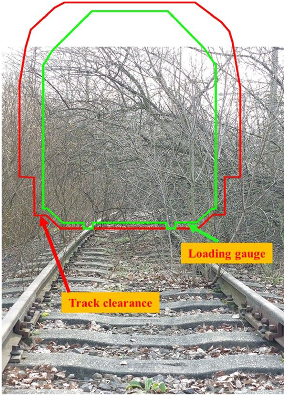
Although, in principle, the design of the track cross-section ensures the accident-free running of trains in all countries. The railway regulations distinguish between two types of cross-section (Figure 1). The smaller, so-called loading gauge, must not allow any part of the train, including the load, to hang out, and the larger, so-called structure gauge, must not allow any object from the track environment to hang into it. The free space between the two ensures the unhindered passage of trains. However, some military equipment (such as fighting vehicles) cannot fit into the gauge, because of their size, but their transport by rail offers considerable advantages. In some cases, rail cargo may be allowed to extend beyond the loading gauge, but it must not protrude from the structure gauge. When organizing such deliveries, due care should be taken and during the reconnaissance process, it should be checked that no objects are protruding into the structure or loading gauge.
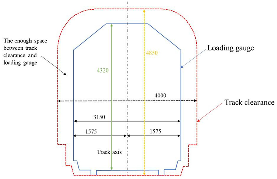
Dimensions of structure and loading gauge, unit: mm.
The geographical environment, including topography and terrain, should be considered to what extent bad weather conditions (e.g. rainfall, snowfall) are a hindrance to the military use of the railway line under consideration, as there may be areas in the battlefield where heavy precipitation (e.g. snow) may prevent the use of the railway line or only after clearing operations (operation of towing vehicles using snow plows).
The topography and ground conditions can have an impact on the design of railway lines and their use. For example, on a line built on a mountain slope, the performance (tractive effort required) of the towing vehicles may have an even greater influence on the composition (towable weight) of the military trains and, accordingly, on their movement. In addition, the natural topography of the area around the railway line may also impede the movement of the trains (e.g. when the notch in the gauge slides or collapses).
When inspecting railway stations, it is necessary to establish the number of station tracks and, where possible, which of these can be used for train movements and loading, and which are electrified and which are not. This requires knowledge of the track connections, the location of the station loading bays and depots, the station loading equipment (e.g. cranes) and the means of lighting. Train movements may be limited by the length of trains that can enter a station. These lengths must be determined at the time of reconnaissance. At railway stations, the adequate length of stations is indicated by a separate object and a train can enter the section between the two objects in such a way that no collision occurs when the train is traveling on the other track. The task is therefore to determine the exact position of these objects. It is important to note that the longest train in Europe can be maximum 740 m.
To accommodate the staff, it is necessary to assess the layout of the station building, its individual rooms, water and electricity supply and rest facilities. It is also necessary to obtain information on communication facilities, IT networks, and radio circuits.
The reconnaissance of the station’s road interfaces (station accessibility, types of station roads) must be carried out in order to enable logistics organizations to assess the military usability of the infrastructure element on the basis of a number of factors. Roads of sufficient capacity and track width are needed for the movement of military equipment, and in particular oversized and overweight vehicles, so that access to rail loading areas can be safely achieved, that is, rail loading and unloading can be carried out without hindrance. Here it is worth identifying the access roads to the station, their types (e.g. dirt or hard surfaced), restrictions and traffic management.
It is essential to assess guard protection options in order to safeguard military materials, equipment, personnel, and equipment. It is recommended to examine the conditions under which station areas, in particular warehouses, passenger and rest areas, toilets, front and side loading areas, can be protected, supplemented by military equipment (e.g. rapid deployment wire fences, mobile watchtowers).
In the battlefield, in addition to railway stations, there may also be open-line service areas where no train service is possible, and therefore, they are not considered as stations, but may be suitable for passenger traffic or loading operations. These may include:
a stopping place: suitable only for stopping passenger trains for the purpose of alighting and embarking passengers (crew);
a loading bay: a service area not open to passenger traffic, where one or more tracks branch off from the open line for the purpose of loading freight wagons;
a stopping-loading point: a service area which serves both functions. 12
In a previous article, we presented an extended visual inspection checklist for the reconnaissance of railway networks, whose several elements can be inspected using drones. The technology will allow for the acquisition of adequate images of the condition of the railway track in almost all details, taking into account the above, so that a decision can be made as to whether it can be used for planned military mobility and transport missions.
To collect this type of logistical information, it is advisable to use a tool that facilitates rapid and accurate visual inspections of the site. The use of UAVs is one such option, and UAVs can contribute to the military assessment of infrastructure elements in transport subsectors such as rail. 13
3. Visual inspection of railway infrastructure with the use of drones
In the previous chapter, some elements of the complex, rail sector–based visual inspection checklist defined in the previous chapter can be assessed using drones. Military mobility can be achieved on the railway infrastructure surveyed with drones, allowing for the highest possible quality of transport tasks. The use of drones in rail transport is already common (e.g. for track inspection), but their application in military reconnaissance is not yet developed. In the following, the requirements and rules for the use of drones will be defined, and the feasibility of visual inspection tasks will be analyzed. The effectiveness of performing logistical reconnaissance will be demonstrated through field experiments.
The current flight capabilities of UAVs do not allow the reconnaissance of entire railway lines, but they do allow the reconnaissance of sections of lines and, most importantly, stations. The complexity and intricacy of the rail transport system requires that all objects, from rail components to buildings or large landmarks, are surveyed as far as possible. This is necessary in order to determine the parameters of the trains that are to run (e.g. gauge). Many parameters have to be examined for the operability of the system, and these have to be recorded in the visual inspection list.
The items on the visual checklist are selected on the basis of suggestions from rail and military transport experts. This may be done in a working group led by a logistics reconnaissance soldier. The research aimed at determining whether the elements of the visual checklist could be examined by drones and whether the parameters required for the use of a particular railway infrastructure and the transport conditions could be determined based on the examined elements. To this end, a drone was flown over railway sections and into a tunnel and pictures were taken of a railway station. From the drone images, a 3D model of the track was created in order to determine the parameters, and the images were used to check the presence of certain railway objects (e.g. signals), which were then checked manually.
3.1. Requirements and regulations
The observation of railway infrastructure with drones has been a concern of researchers and development engineers for several years. The application of UAVs in the railway sector is possible in several areas. Based on the topic of this article, the following areas of railway infrastructure monitoring can be identified based on an Italian study:
monitoring critical infrastructure elements (e.g. bridges, tunnels, stations);
monitoring of the safety of the environment (e.g. detection of objects protruding into the structure gauge);
safety monitoring (e.g. detection of track faults). 14
However, the use of drones is limited by a number of factors. First of all, the weather conditions can be mentioned here (e.g. heavy rain or strong winds). However, reconnaissance cannot be carried out without taking account of weather conditions, and natural phenomena can cause damage to the orbit (e.g. overhead line falls down), which, if detected in time, can prevent serious accidents and increase the success of the mission. It is therefore particularly important that drones can be used in adverse weather conditions.
Another limiting factor is the load capacity of drones. If it is necessary to take images in the dark, the flying vehicle must be equipped with a reflector or infrared camera, and carrying the hardware for instant image processing adds to the burdens.
Currently, the flight time and distance are negligible compared to the extent of the railway tracks. A flight time of 20–30 minutes and a range of 30–40 km is sufficient to detect only a few stations, after which the device needs to be recharged. This may necessitate the establishment of loading bays along railway lines, making it difficult to carry out reconnaissance missions.
The existence and reliable operation of a WIFI network with sufficient signal strength along the entire railway infrastructure is essential for the establishment of a proper data connection. This may be limited by the railway overhead line, whose electromagnetic emissions may attenuate WIFI signals. In most cases, drones are guided remotely for reconnaissance purposes, which requires the control crew to be able to monitor the flight environment at all times. This requires a stable data link during the flight. The flight of an uncontrollable drone can have serious consequences, as it can crash into objects and create a dangerous situation (for example, an overhead line which can be torn down or to a moving train).
Another important requirement is to take appropriately sharp pictures and to be able to evaluate them. In their study, Balázs Horváth and Richárd Horváth propose the distance per pixel (DpD [cm/px]) as a measure for determining the distance at which images are taken with a suitable resolution. 15
International and national legislation regulates the use of drones, while an Italian study describes the technology and technical conditions for the use of drones on railways. 16 However, it does not address the behavior in the overhead line environment. The study by the UN working group also only assumes, by mentioning technical limitations and risks, that the overhead contact line in operation may cause interference with the equipment on board drones. 17
3.2. Investigating the detection capabilities of drones on railway infrastructure
Experiments were conducted to verify the detection capabilities of drones. The experiments included open-line and railway station mapping. First, drone images were used to investigate the condition of the railway open-line infrastructure and the possibilities of identifying inappropriate objects. The measurements were carried out in tunnels and on open track. In the second case, we used drones to reconnaissance a railway station and its immediate surroundings and identify specific infrastructure elements and their usability.
3.3.1. Test method
3.3.1.1. Open line
The open-line experiment was designed to detect small anomalies in the railway infrastructure (detection of track defects, e.g., broken rails) and to identify small inappropriate objects in the infrastructure environment (avoidance of accidents, terrorist acts). Another requirement was the measurability of certain parameters based on the images. These were measured on site using a hand-held measuring device and the two values were compared.
One of the characteristics of rail transport is that it is electrically powered, so we wanted to investigate the effect of the overhead line in operation on the recording. After consulting railway experts, we abandoned this attempt because the experts could not guarantee the integrity of the flying equipment. Thus, during our measurements, we only approached the railway overhead line to a point where the flying object itself did not indicate any interference (about 35–40 m).
The following locations were selected from among those meeting the above conditions, taking into account the train traffic and reversing movements of the site:
Budapest Children’s Railway area (a narrow-gauge line for tunnel measurements);
“Óbuda” station power plant siding (for open-line measurements).
The images were processed using AGISOFT Metashape 1.7.1 professional edition image processing software. After entering the appropriate parameters, the processing of the images and their transformation into 3D models was performed almost automatically by the software. After adding the folder containing the files, the images were aligned using the Align command. Once the software had successfully identified the correct location, a layer called Tie Points was created, which showed the points that would be used to build the model skeleton (Mesh), the Dense Cloud and the actual textured 3D model (Tied Maps). The sparse point cloud now shows the surveyed area, with many points in the immediate or distant environment. These had to be manually removed to produce a detailed model of our target area only. In the next step, we created a Mesh layer based on the sparse point cloud, which is now a continuous surface shape. The Mesh provides the basis for the 3D model, on which the software created a texture mesh based on the photographs, giving a pervasive representation of the real surface. From this, we can then use the photographs to create a plot with each point of the ground at exactly 90 degrees from the top view, so we can see the result of the drone survey in map view (orthophoto).
3.3.1.2. Railway station
For railway stations, we selected as a target area for a flight a transport hub where the railway station has several direct road connections, so that the assessment of the infrastructures could be carried out simultaneously with the execution of a flight. When selecting the location, we took into account the fact that transport infrastructures located in the vicinity of a military facility play an important role in the effective redeployment of military personnel and assets from the garrison to the designated area of operations, one of the prerequisites for which is the successful use of the rail and road networks according to military needs. Based on these criteria, “Tata” railway station was chosen.
To test the applicability of the UAVs in the railway station, we used a DJI Phantom 4 Pro+ drone (Figure 2), as it was considered suitable for the reconnaissance tasks. When flying the drone, we first performed a reconnaissance of the railway station and then of the associated road networks. The aerial photographs taken from the visual inspection lists were then evaluated (to identify the dimensions) using Google Earth Pro+.
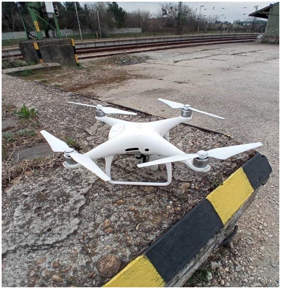
DJI Phantom 4 pro+ drone.
3.3.2 Results and findings
3.3.2.1. Tunnel measurement
The tunnel has the peculiarity of being located in an arc, so that it is not visible through it, that is, it is completely dark inside (Figures 3 and 4). The tunnel also contains life safety settings (Figure 5).
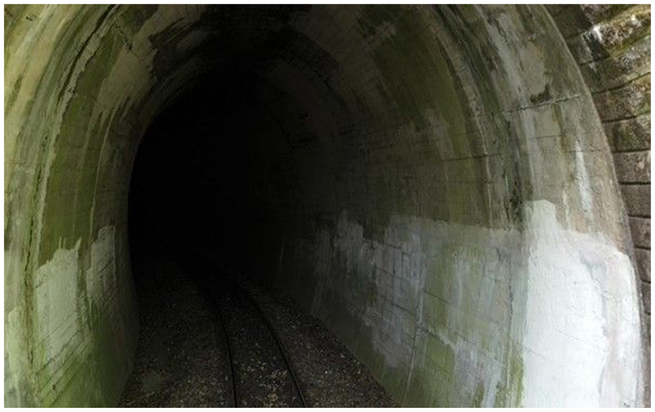
Entrance to the tunnel.
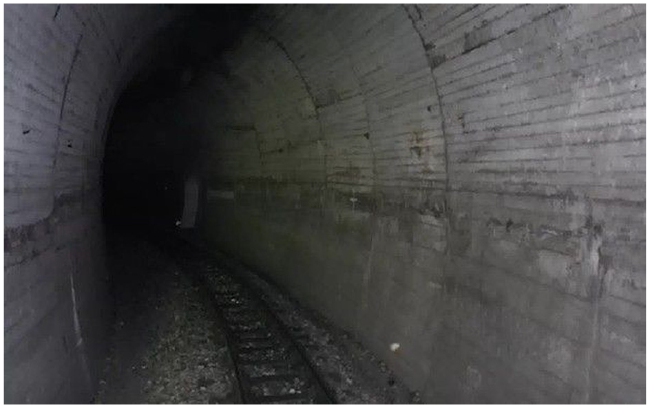
The inside of the tunnel.
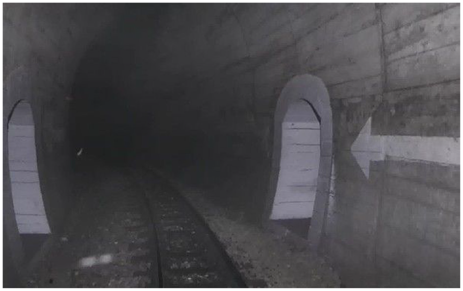
Setting points in the tunnel.
The total darkness caused extreme difficulty, and during the experiment the aircraft was damaged and crashed. A 3D model of the tunnel section (Figure 6) was created from the in-flight images and used to make measurements of the tunnel parameters.
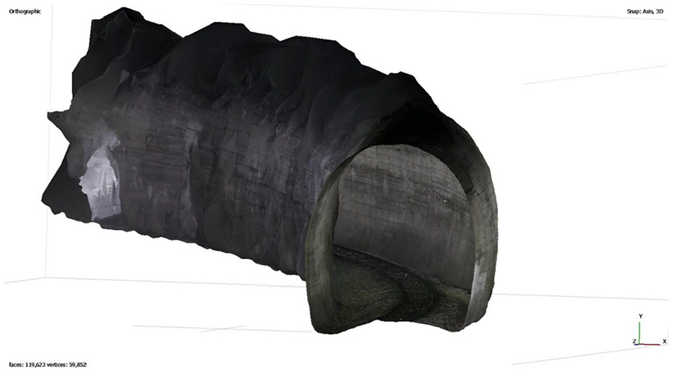
3D model of the tunnel.
The measurements were accurate in terms of the height and width of the tunnel (Figure 7); however, the measured gauge spacing in the tunnel was significantly different from reality (760 mm instead of 538 mm measured gauge spacing, Figure 8). This is already a significant error which could have a decisive impact on the success of reconnaissance in theater.
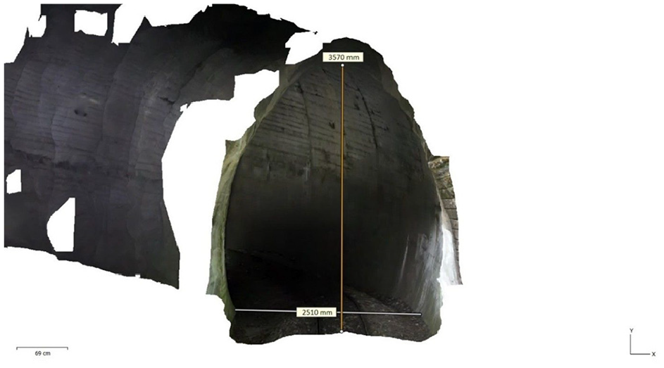
Reconstructed dimensions of tunnel height and width.
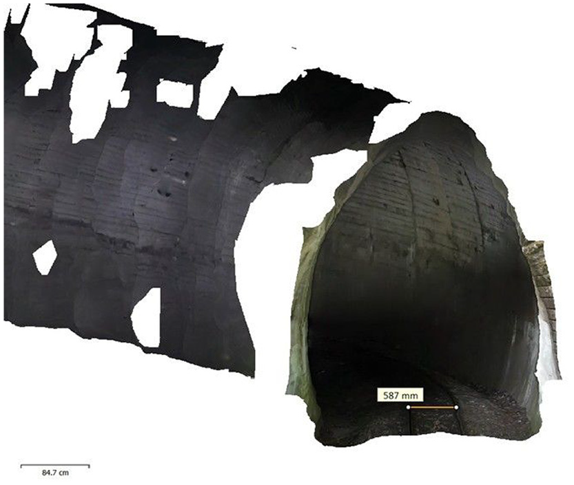
Dimension of the track-axis distance in the 3D model.
The slope of the track resulting from the ratio of the calculated length value to the height was calculated to be 44.7‰, which would only allow gear traction to be implemented on the track (maximum slope value for adhesion traction is 30–35‰, Figure 9). It can therefore be seen that the 3D model did not provide a satisfactory result for the calculation of this parameter.
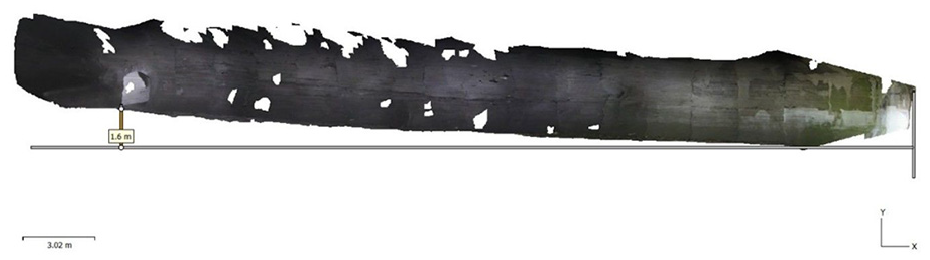
Measurement of the tunnel rise.
The following conclusions are drawn from our tunnel measurement results:
the proper selection of flying devices and remote control of drones in railway tunnels, especially in curved tunnels, requires extreme expertise, but it is also a prerequisite for the substitutability of human reconnaissance or control;
the accuracy of the measurements cannot be considered adequate due to poor lighting conditions;
a 3D model of the tunnel can be drawn from the images taken by the drone;
the confidence model shows that during the operation the flying device identified the tunnel wall with a high degree of confidence, so that the gauge of the space in which the trains can run can be determined;
photographs can be used to identify the safety shelter in the tunnel.
From a reconnaissance point of view, the tunnel inspection has resulted the identification of individual objects and has provided information on the state of the infrastructure, that is, its usability and operating conditions.
3.3.2.2. Open-line measurement
During the open-line survey, the condition of the track and the visibility of inappropriate objects were examined. For this purpose, a crushed stone bedding photograph was covered with a box and placed next to the inner edge of one of the rails, which was also covered with stones found at the track (Figure 10). In addition, stones and tree branches were placed on the unused track rails and a small yellow box was hidden in the crushed stone bedding. During the survey, it was also possible to investigate the electromagnetic field of the nearby railway overhead power line, but only to the extent that the aircraft safety system was signaling interference when the images were taken (at a flight altitude of between 15 and 40 m).
Unsuitable object in the track spacing.
Based on the measurements, the following conclusions can be drawn:
a 3D model of the track could be created from the recordings (Figure 11);
the confidence model shows that the model reliability is significantly higher than the tunnel model for an open line (Figure 12);
based on images taken at different flight altitudes, the visibility of each object varied, the hidden yellow box could only be identified from photographic images, it was not identifiable in the confidence model (Figure 13);
the accuracy of the results of the size determinations made from the model shows a significant variance, with error rates ranging from 1% to 20%.
To verify the structure and loading gauge measurements, images were taken focusing on the track. As shown in Figure 14, vegetation can obstruct the progress of the fittings, so that preliminary work is required to stress the line.
Measurement of the tunnel rise.
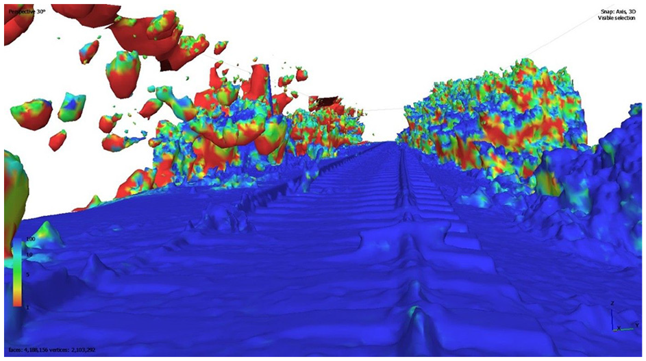
Confidence model of the open line, with mismatched objects clearly visible.
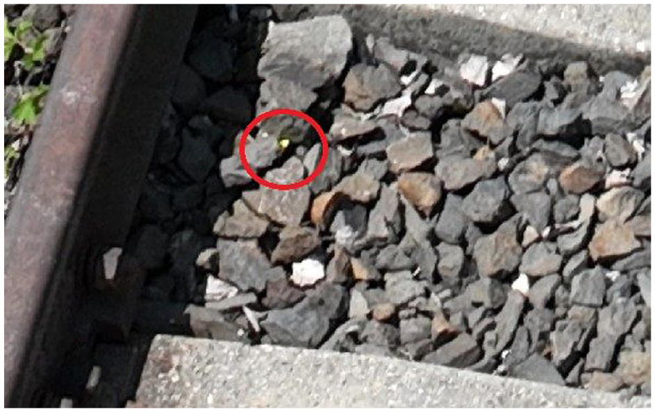
Visibility of the yellow box hidden in the bedding.
Alignment of the structure and loading gauge patterns to the track image.
From a reconnaissance point of view, the detection of objects hidden in the bedding is not good, it is a disadvantage that should be overcome, the parameters (and obstacles) can be well defined under good lighting conditions.
3.3.2.3. Railway station measurements
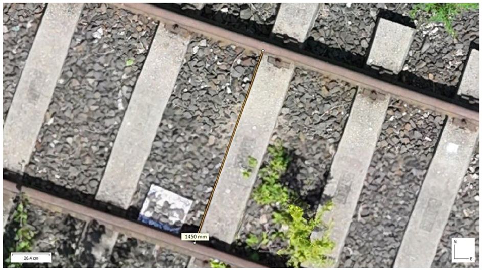
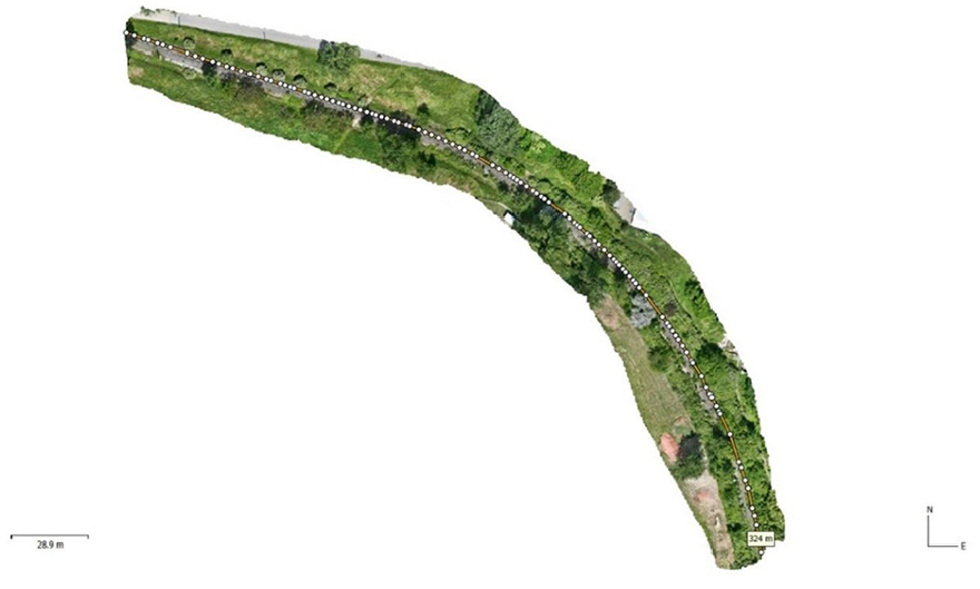
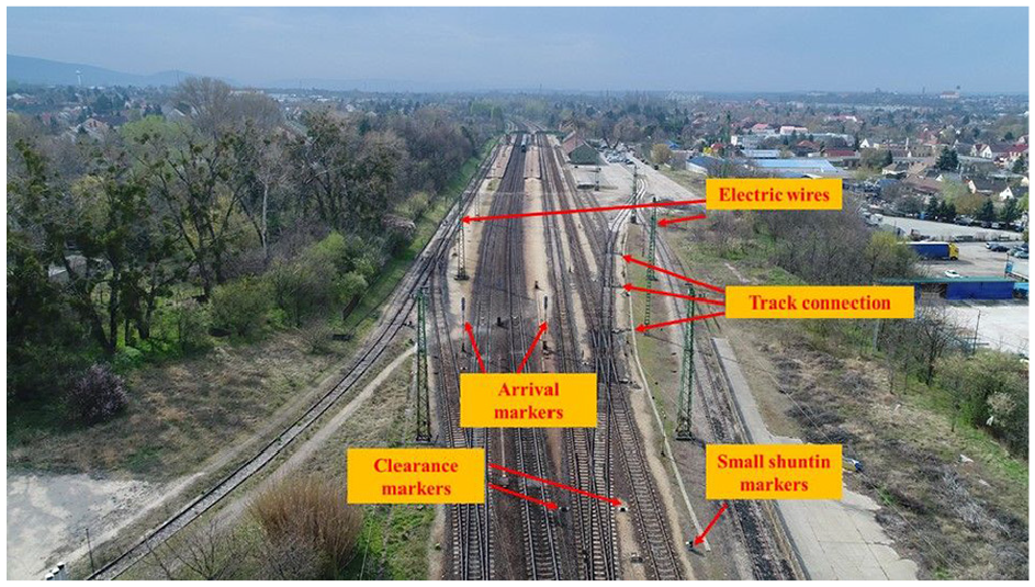
For the baseline data, the visual survey was carried out under good visibility conditions on 07 April 2022. The WGS84 coordinates of the railway station are: latitude 47° 39’ 50” N, longitude 18° 19’ 38” E. The first step of our investigation was to identify the type of station. As the first step of our analysis, we identified the type of station. The drone image (Figure 15) clearly shows the station’s railway facilities (buildings, tracks, loading platforms, etc.). From the image, it can be seen that the necessary guarding military equipment can be installed in the area, thus allowing the protection of materials, equipment, people, and trains.
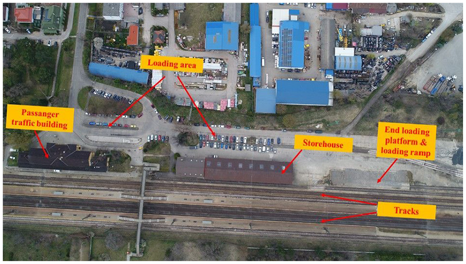
Drone image of Tata station.
Going beyond the criteria in the visual inspection list (station accessibility, type of station roads), the aerial photographs show that the station can be accessed, for example, via the developed roads from the main road No 1, which are paved and suitable for transporting military equipment (Figure 16).
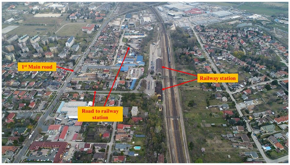
Drone image of the roads around the railway station.
The usable length of the tracks was measured as 850 m for the main through tracks (Figure 17), 722 m for the train receiving tracks, 730 and 710 m for the storage tracks, and 90 m and 260 m for the front and side loading tracks. The track gauge was set at 1.51 m.
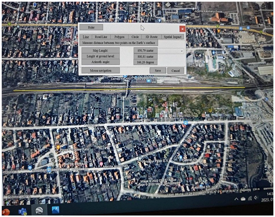
Determination of the length of the main through-track.
The data were cross-checked with the information in the Tata Station Implementation Instruction No. 49486-10/2015/MAV issued by the Hungarian State Railways (MÁV). The discrepancies were in the order of ±20 m for track length and +0.075 m for track gauge (standard gauge 1435 mm). It should be noted that the track gauge deviations are outside the margin of error, as a difference of only 2–3 mm is allowed in rail transport.
The discrepancies are due to the fact that the aerial photographs were fitted to their geometric positions by a rudimentary affine transformation, performed using Google pro+. To obtain better measurement results than this, it is necessary to measure (by way of alignment point selection) some co-planar field points in the field and to create maps, for example, using advanced photogrammetric target software, to obtain more accurate data, which was used for the open line measurements.
The station is electrified and the outdoor units of the protection equipment are identified in Figure 18.
Identification of station equipment.
The axle loads of the tracks could not be determined from the aerial photographs, as the drone did not have the equipment (e.g. instrumentation or system for LIDAR application) needed for more accurate measurements (3D measurements).
By examining the loading aids and loading areas, we found that a side loader was constructed directly adjacent to the warehouse, and a front and side loader were also constructed at a minimum distance from the building. Equipment to assist in the loading and unloading of goods (e.g. cranes, lifting equipment) was not recorded as being available at the station, and therefore special attention should be paid to the provision of the necessary loading equipment when planning and organizing military transport.
The station measurement gave satisfactory results from a reconnaissance point of view, objects were detectable and traffic conditions were identifiable.
The lack of measurements and the impossibility of drone surveys of building interiors also means that it is worthwhile to carry out a visual inspection on the ground, where possible, to provide real data for planning and organizing rail transport.
3.3. General findings
Overall, it can be stated that the drone detection method we have chosen is suitable for inspecting railway infrastructure and detecting inappropriate objects. We hypothesize that one of the possible reasons for the occurrence of the tunnel accident could have been the too large size of the drone; however, in unknown terrain, it is not always possible to select the optimal flying device; therefore, the flying experience with UAVs is also of crucial importance. The following general conclusions are drawn from the visual inspection experiments with drones:
the availability of flying equipment with images of sufficient resolution is necessary to assess the condition of the railway infrastructure, as this is the only way to identify defects in the rail infrastructure (e.g. cracks, breaks);
the 3D models are adequate for diagnostic purposes;
the detectability of inappropriate objects placed on the rails was adequate, so that traffic conditions could be prevented by drone inspections,
the dimensions of the railway infrastructure could be determined from the images and models, but the measurement accuracy of the experiments was not adequate, requiring the use of a more accurate flying instrument;
imagery can be used to identify objects hidden between infrastructure elements, thus preventing certain terrorist acts or covert attacks;
very precise measurements are needed to determine the exact dimensions of the rails;
the choice of the right flying equipment and skilled personnel is a prerequisite for achieving the right results.
Based on the logistical reconnaissance experiment with UAVs, it can be stated that the procedure is suitable for the inspection of railway infrastructure parameters according to the criteria defined in the visual checklist and that it can give satisfactory results, for which the necessary requirements will be defined below.
4. Requirements for drones for logistical reconnaissance of railway infrastructure
On the basis of our experiments, the following set of requirements for UAVs for the logistical reconnaissance of railway infrastructure is established.
4.1. Regarding records
The UAV shall take photographs and moving images that allow it to be identified:
elements of railway and road infrastructure;
the location of railway and road tracks;
the surroundings of the infrastructure elements;
the dimensions of the railway and road tracks;
be able to take high-quality, high-resolution photographs and videos to increase the efficiency and accuracy of the evaluation and, where possible, be equipped with a precision measuring device to accurately measure the track gauge or even the width of the rail head.
4.2. In relation to the flying tool
Based on the information gathered from the aerial survey, the requirements for unmanned aerial devices are as follows:
have (on a full charge): a minimum flight time of 25 minutes and a replaceable battery, so that surveys of up to several hours can be carried out with short interruptions;
the on-board data recorder must be capable of recording a minimum of 4 hours of video, allowing for temporary storage of the results of larger surveys;
the flight distance must be sufficient to survey longer lines (open tracks, station spacing), that is, a minimum of 5 km, but longer line sections may require up to 10 km, for which fixed-wing instruments offer a more efficient solution than their multirotor counterparts;
be able to fly at altitudes of up to 500 meters in order to obtain a comprehensive picture of the infrastructure and its surroundings and to carry out the survey without being detected.
The range of parameters required can of course be extended depending on the possible conditions of use (e.g. operating temperature range), but only the most basic requirements have been defined here on the basis of the visual inspection carried out. These requirements can also be taken into account for the on-site inspection of airports and ports, as the inspection criteria can also be applied to these infrastructure elements.
On the basis of the above requirements, UAVs can be identified that are suitable for the logistical reconnaissance of rail networks and can assist the information gathering processes of the surveyors to be carried out efficiently.
Thanks to the wide range of parameters available for the drones available, it is possible to choose the device with the technical solutions best suited to the nature of each task. However, it is worth pointing out that the most important features of transport infrastructures do not require specialized equipment, as most of the information can be obtained by taking high-quality images and post-processing them in software. As a result, even medium- to high-end UAVs developed for civil use may be able to perform these tasks.
4.3. Further application conditions
The use of artificial intelligence can increase the efficiency of infrastructure investigations and reconnaissance further. The drone, which is able to detect certain faults and anomalies on its own, can send information to the person carrying out the reconnaissance, allowing rapid action to be taken. To realize everything listed above, adequate data connectivity is necessary to achieve the above, and ensuring the security of data connectivity, i.e., strengthening cyber defense, is a key area of concern. At the same time, the researchers also draw attention to the risks of using artificial intelligence (AI; e.g. ethical and existential issues)18,19 and to the fact that AI algorithms are no different from other software in terms of their vulnerability to cyber-attacks, 20 which further increases the need for cyber defense and the need for appropriate regulation.
5. Conclusion
The reconnaissance provides the basic information for planning military logistics processes. The detection of transport networks that enable the realization of transport processes is a particularly important area. With the right information, measures can be taken to ensure that military transport operations can be carried out successfully and safely.
In this article, we have looked at the possibilities for reconnaissance in one of the transport subsectors, the rail sector. The railways are an essential means of transport for the mobility of theater of operations, and the rationale for our study is therefore well founded. In order to achieve a suitable reconnaissance result, we have used drones to survey some elements of the railway network and have drawn conclusions based on the results of these field experiments.
Prior to conducting the experiments, we defined the aspects necessary to successfully carry out the reconnaissance, taking into account the planning tasks of military transports, and provided a basis for evaluating the results following the flight.
In general, the results of the experiments suggest that UAVs can play a significant role in the logistical surveillance of transport infrastructures, but the results also highlight that in some cases improvements in technology may be needed in the areas of remote control and precise object detection. The results of this study have been evaluated to identify the minimum requirements that need to be taken into account when conducting UAV-based visual inspections in the field, which can significantly increase the effectiveness of logistical reconnaissance of railway infrastructures and thus the success of a military operation.
In our opinion, the use of UAVs can ensure the collection of essential information that can assist in the successful execution of specialized tasks related to logistical reconnaissance. Aerial photographs and videos taken by UAVs can contribute not only to the successful completion of the aspects included in the visual inspection lists, but also to the planning and organization of military transports, and thus can be considered as a basic tool for military logistics of the future. Our results may contribute to solving the vehicle routing problem presented by Korean researchers considering reconnaissance and transportation, which was also formulated by the researchers that the wide observation capabilities of military drones can provide data for the selection of efficient (rail) routes. 21
Footnotes
Funding
The author(s) received no financial support for the research, authorship, and/or publication of this article.