
Abstract
U.S. freeways have come under scrutiny for their adverse impacts on low-income neighborhoods of color, primarily in urban centers. This article offers a comparative historical analysis of the impact of freeways on two communities in Southern California, which were ethnically diverse suburbs. Planning authorities in Pasadena and Pacoima chose freeway routes that displaced a greater share of households of color than the proposed alternatives. Meanwhile, neighboring white, wealthier communities successfully influenced routing decisions in consequential ways. Beyond the visible and immediate effects of the freeways, social inequity and environmental degradation persist in both neighborhoods today.
Keywords
Introduction
“Take me to a strange city where I’ve never been before and point out the areas in which Negroes live and I will lay you some neat odds that I can point out the route of the city’s next freeway.”
1
The construction of freeways throughout the 1960s and 1970s destroyed neighborhoods and displaced residents in ways that have become increasingly visible during our present era of racial reckoning. Scholars have demonstrated that the burden of freeway construction was not equally distributed, leaving poorer neighborhoods of color to bear a disproportionate cost. 2
Southern California played a key role in the development of freeways. The Los Angeles metropolitan region created some of the earliest and most expansive plans for freeway construction, and in 1959, California’s Division of Highways and Public Works adopted a freeway plan that amounted to one third of the length of the entire Interstate Highway System. 3 At first, many scholars viewed Southern California’s freeways as a great achievement. Banham described freeways as one of four Los Angeles “ecologies,” 4 while in his “appreciative essay,” Brodsly celebrated the freeway as “the cathedral of its time and place.” 5 These authors wrote about freeways from the driver’s seat, praising speed and freedom but ignoring their negative impacts on neighborhoods. Throughout the second half of the twentieth century, freeways were enablers of suburbanization and the American dream. But this dream was contingent on prosperity from rising income and home ownership, both of which were racially circumscribed to white populations. People of color were systematically excluded from the “pleasant way of life” that typified Southern California; 6 rather than connecting them to prosperity, the freeways displaced them from homes and businesses and severed their social networks.
Most of the literature on the adverse impacts of freeways focuses on marginalized central-city neighborhoods. Avila narrates the history of the freeway through the eyes of marginalized residents in East Los Angeles who resisted freeway intrusion and subsequent displacement. 7 He finds that while freeways represented monuments of progress for white Angelenos, they left deep scars for the Mexican residents of East Los Angeles. Focusing on Southern California’s Inland Empire, Carpio writes about racial hierarchies that granted mobility to some, while denying it to others. 8 Estrada and Gonzales discuss freeways that displaced Latino/as from the central city to the suburbs east of Los Angeles and explain how they expanded the geography of Latino/a Los Angeles and created Brown suburbs. 9
In this article, we focus on the impacts of freeways on suburban areas, a topic which has been comparatively neglected by scholars. Specifically, we examine freeway impacts in Pasadena and Pacoima, two racially diverse suburbs or satellite cities in Southern California. In both cases, we find that white, affluent residents were more successful affecting freeway routing decisions than communities of color. In Pasadena, the Foothill Freeway/Interstate 210 was routed through its thriving Black neighborhoods, even though the cost and destruction of this routing was higher than the alternative routes. 10 In Pacoima, three major freeway segments cut through an ethnically diverse but largely disenfranchised neighborhood. Following loud opposition from white neighbors in the San Fernando Valley, transportation authorities selected a route for the Simi Freeway/State Route 118 that disproportionately affected lower-income communities of color.
Freeway planning involves top-down state intervention and plans that link to regional networks. Examining the multiple routes that were debated at a local level sheds light on opposing preferences and intentions, as well as the unequal power dynamics among residents. Our research reveals that when selecting the routes for freeway segments passing through Pasadena and Pacoima, freeway planners, supported by local planning departments and city councils, targeted neighborhoods of color and spared adjacent areas populated by wealthier, predominantly white residents. Of course, some freeways were built through white suburban areas—though, as we show, residents in these neighborhoods organized visible opposition. Freeways sometimes took less destructive routes or employed impact-mitigating designs, but what remained stubbornly true is that the voices of wealthy, white residents rang louder than the rest. But routing decisions were also shaped by the deafening silence from—or silencing of—residents of color, who did not have a seat at the table. We argue that these choices indicate white privilege that amounts to what Pulido calls “environmental racism.” 11
In the article that follows, we first summarize the literature to give a brief overview of the adverse impacts of freeways on neighborhoods of color and the rising opposition to their construction. We then turn to our two case studies, where we demonstrate freeway planning and siting that adversely affected certain residents.
Literature Overview: The Toll of Freeways
Boosted by the Federal Highway Act of 1956 and generous federal funding, the U.S. interstate highway program connected and radically transformed most major American cities. Biles, Mohl, and Rose review the history of this program that produced nearly 43,000 miles of highways across the nation, one of the largest public works in history. 12 Spanning several decades from the 1950s to the early 1990s, freeway construction aspired to modernize the nation, relieve congestion, optimize productivity, reduce crashes, and bolster military defense. 13 Initially, there was so much funding available that “state highway engineers literally couldn’t build highways fast enough.” 14 The program’s financing (90% of capital costs covered by the federal government) and organizational structure (planning managed by state highway engineers with prior experience designing high-speed, high-capacity rural highways) incentivized the construction of freeways through urban neighborhoods. But dwindling funding and emerging criticism brought the age of large-scale freeway construction to an end in the early 1980s. 15
Early scholarship echoed the boosterism of interstate proponents and celebrated highways (or freeways, as they are called in California) as unprecedented achievements of engineering, city planning, and public policy. 16 However, in the early 1970s, some scholars began challenging the logic and cost of highway modernization programs 17 —even dubbing them a “superhoax.” 18 Later scholarship situated the Highway Era within complex political, and socio-cultural circumstances, exposing its impact on neighborhoods and communities. Recent editions of seminal transportation works were revised to acknowledge highways’ damaging effects, which were not originally discussed. 19 Still, the full effects of the highway system continue to be understudied and underestimated. 20 Nevertheless, scholars have begun to show how transportation planning displaced certain communities, restricting their access to housing, education, and economic opportunities, simultaneously causing significant health disparities 21 —all while affluent, white communities often successfully shielded their neighborhoods from the impacts of highway construction. 22
Highway impacts are diverse and interconnected. 23 As highways cut through U.S. cities, they deliberately targeted “blighted” areas and caused displacement. 24 Enabled by federally backed mortgages and infrastructure, mostly white residents left central cities, using freeways to commute from their new suburban homes to their jobs. 25 Population decline in urban centers throughout the latter half of the twentieth century can be partly attributed to highway construction. 26 This process of metropolitan decentralization resulted in disinvestment, limited mobility, reduced housing options, and diminished job opportunities for those central-city residents left behind. 27 As jobs moved to the suburbs, many of these residents encountered a “spatial mismatch” between their homes and potential employment, 28 having to travel longer distances and pay higher transportation costs. 29 The same populations adversely affected by freeways were also exposed to multiple environmental hazards. Abundant evidence links a neighborhood's proximity to freeways with its residents’ respiratory problems, cancer, and premature births. 30
Freeway impacts on some California communities were particularly visible. In 1961, the local Black newspaper California Eagle addressed the detrimental impacts that freeway construction was having on Los Angeles Black neighborhoods: White residents can find someplace else to live without undue hardship. The Negro is put into a bad position. He can’t go out to the new suburban areas and buy a new home simply because he has the money and the desire....After it is all over, the Negro victim of freeway construction will wind up, more often than not, in another restricted area where he will have to pay through the nose for a second-hand home in a community a cut below that in which he formerly lived.
31
Opposition to Freeways
As highway impacts became progressively visible, opposition started forming in dozens of cities around the country. The first “freeway revolt” took place in San Francisco in 1959; more anti-highway protests followed in the 1960s. 32 The most visible and successful protests were led by white, affluent communities. 33 Avila argues that communities of color were at a disadvantage because they lacked the time, language skills, information, and power to organize and resist at the same capacity as their wealthier, white neighbors. 34 Only certain communities successfully deterred freeways from tearing through their neighborhoods; this success often came at the expense of less powerful residents of color in adjacent neighborhoods.
In the 1950s and 1960s, a multicultural coalition opposed the Golden State Freeway/Interstate 5 in East Los Angeles, and Black communities resisted the proposed route for the Santa Monica Freeway/Interstate 10 in West Adams. Despite protests and grievances, these freeways followed their planned course, destroying residences and establishments—including what the California Eagle described as “the most prosperous, best kept and most beautiful Negro-owned property in the country.” 35 Boyle Heights and West Adams were central-city neighborhoods, but the planning and impacts of freeways passing through suburban communities were quite similar.
Uncovering Evidence: Research Design
We selected two suburban case studies—Pasadena and Pacoima—and used archival research and oral histories to analyze the impacts of freeways on their neighborhoods of color. For each case study, we drew on both primary and secondary sources. We began by searching for newspaper articles from 1950 to 1980 in archival databases (such as ProQuest and the California Digital Newspaper Collection) using geographic and topical keywords. We identified 140 relevant newspaper articles from 13 local newspapers, some of which are no longer in print. 36 These articles gave us information on timelines and milestone events, on stakeholders engaged in decision-making, and expressed public sentiments during freeway planning and development. Moreover, they explicitly revealed that multiple routes were publicly considered and contested.
We complemented our archival research with other primary sources: planning documents, professional studies, maps, and correspondence associated with the Pasadena General Plan of 1962 and the Community Development Plans for Arleta-Pacoima (1973–1974). For the Pasadena study, primary source material was pulled from USC’s Digital Library Archive, UCLA’s Center for Oratory Archive, the Pasadena Public Library’s planning literature repository, and the California Department of Transportation’s (Caltrans) Research Library. Interview materials with past residents were collected from the Pasadena NAACP, A Noise Within Regional Theatre, and California Polytechnic University, Pomona Professor John Lloyd. For the Pacoima case study, we drew from archives at California State University Northridge (CSUN), including papers of chambers of commerce, resident associations, and planning commissions, as well as the Los Angeles Department of City Planning and the City Archives and Records Center, where we reviewed early drafts of the community development plans for Arleta-Pacoima and supporting documents. 37 We also examined past U.S. Census data to analyze changes in the neighborhoods’ demographic composition over time. Additionally, we examined redlining maps, accessed via the Mapping Inequality, as well as Pasadena’s 1995 Ethnic History Research Project. For Pasadena, we consulted with historian John Lloyd and Bridgette Ramirez at A Noise Within, who have studied the history of freeway construction and Black communities, respectively, in the area. For Pacoima, we consulted with local historian and President of the Pacoima Historical Society Crystal Jackson. We found significantly more archival data and oral histories in Pasadena, which is its own municipality, than for Pacoima, a suburban part of the larger City of Los Angeles. We, therefore, conducted additional interviews in Pacoima with civic groups, community members, and a dozen former residents who had experienced freeway construction firsthand. Several of them still live in Pacoima, though not in the same location.
We use the aforementioned archival and qualitative information to reconstruct and present planning processes and decisions that eventually led to specific freeway routings through neighborhoods of color in Pasadena and Pacoima. We also cite quantitative findings of the socioeconomic effects of freeway construction from the broader research project from which this paper was drawn. 38
Freeway Planning for Pasadena and Pacoima
Advancements in technology, the availability of federal funding, and the opening of the Arroyo Seco Parkway in 1940 (the first freeway of the West), drove the highway construction boom in Southern California. 39 In a 1946 planning report, the Los Angeles Metropolitan Parkway Engineering Committee laid out a vision for a new regional transportation network. 40 On the cover, “parkways” superimposed over existing neighborhoods revealed the planners’ vision for a modern city and an efficient transportation network. Under the framework of the 1958 Master Plan of Freeways and Expressways and the 1959 California Freeway System plan, planning authorities proposed connections between downtown Los Angeles and outlying suburbs, as well as links connecting suburbs to each other. 41
Pasadena and Pacoima stand out as comparable examples of freeway routing in the suburbs. As Figure 1 shows, they were among the very few suburban areas in Los Angeles during the era of freeway construction that had enclaves of color. Pasadena was a long-established municipality, 11 miles northeast of downtown Los Angeles; its neighborhoods of color were primarily home to Black residents. Pacoima was a relatively new postwar suburb when the freeways arrived, home to a diverse Latino/a and Black population. Suburban Freeway Sites, People of Color by Census Tract, Central Los Angeles County, 1970. Data sources: calculated by Paul M. Ong, Chhandara Pech, Abigail Fitzgibbon, and UCLA Center for Neighborhood Knowledge team in Anastasia Loukaitou-Sideris, Susan L. Handy, Paul M. Ong, Jesus M. Barajas, Jacob L. Wasserman, Chhandara Pech, Juan Carlos Garcia Sanchez, Andres F. Ramirez, Aakansha Jain, Emmanuel Proussaloglou, Andrea Nguyen, Katherine Turner, Abigail Fitzgibbon, Francois Kaeppelin, Felipe Ramirez, and Marc Arenas, “The Implications of Freeway Siting in California: Four Case Studies on the Effects of Freeways on Neighborhoods of Color,” ed. Jacob L. Wasserman (Los Angeles and Davis, CA: Pacific Southwest Region University Transportation Center, March 2023), https://escholarship.org/uc/item/7mj2b24q from 1970 U.S. Census (Steven Manson, Jonathan Schroeder, David Van Riper, Tracy Kugler, and Steven Ruggles, IPUMS National Historical Geographic Information System: Version 17.0, 2022, https://doi.org/10.18128/D050.V17.0); Caltrans, SHN Lines (Sacramento, CA: California State Geoportal, August 30, 2023), https://gis.data.ca.gov/datasets/77f2d7ba94e040a78bfbe36feb6279da/explore; Esri, USA Parks, December 27, 2023, https://www.arcgis.com/home/item.html?id=578968f975774d3fab79fe56c8c90941.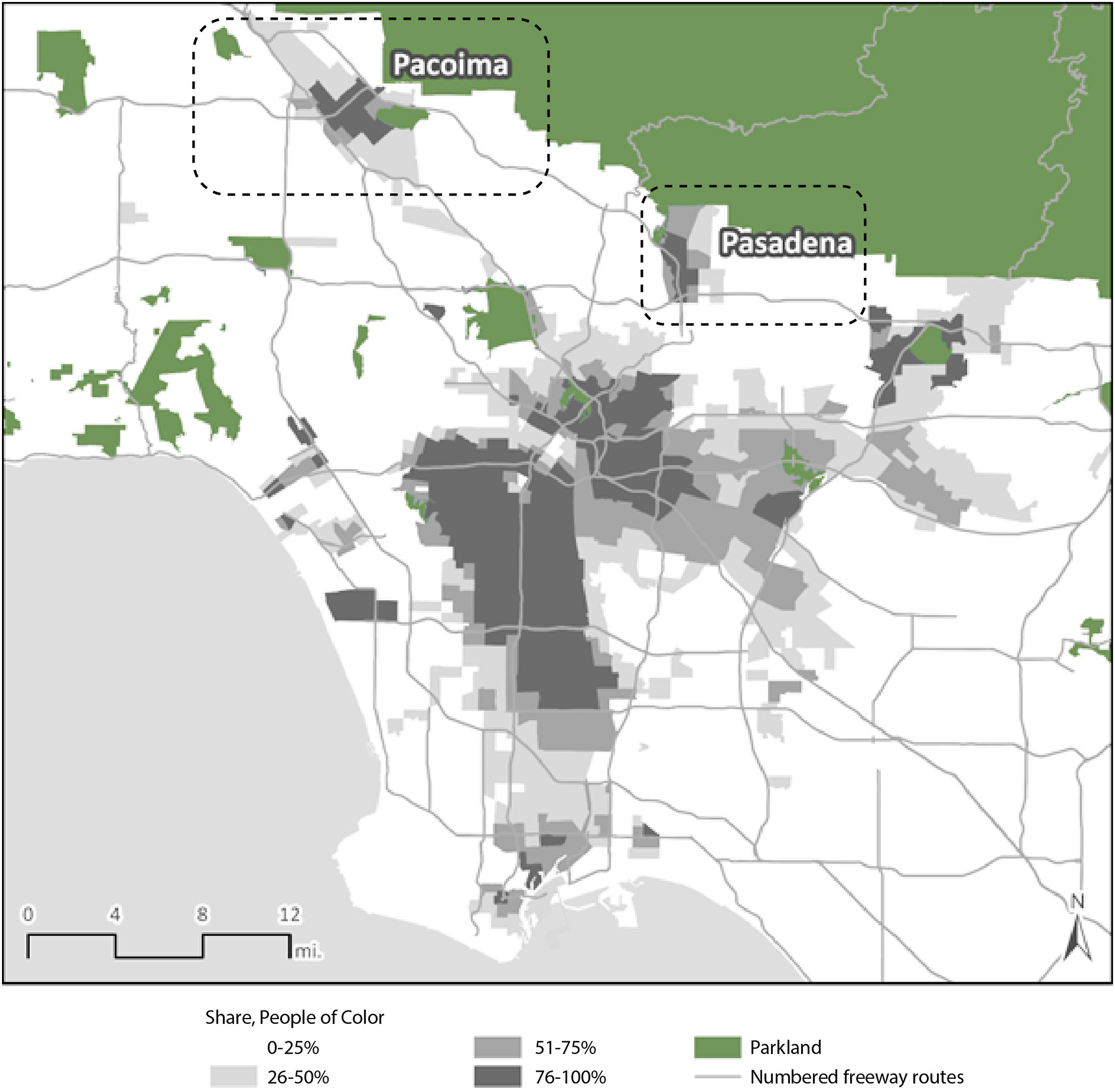
Pasadena
In the 1950s, Pasadena had a diverse and rapidly growing population that was highly segregated within the city.
42
Black residents, who had doubled in number from 1940 to 1950,
43
along with Mexican American, Japanese American, and working-class white families, lived in single-family and multi-family homes in northwest Pasadena
44
in the Orange Grove-Lincoln and Fair Oaks neighborhoods (Figure 2), as a result of restrictive racial covenants that prohibited them living elsewhere in the city.
45
By one estimate, three fifths of the properties in Pasadena had such restrictions in 1942, as realtors went door-to-door to get white homeowners to sign racial covenants.
46
By 1960, approximately 80 percent of northwest Pasadena residents were people of color, compared to 20 percent elsewhere in that city.
47
Pasadena Neighborhoods and Share of Population of Color. Graphic by authors; data source: calculated by Ong, Pech, Fitzgibbon, and UCLA Center for Neighborhood Knowledge team in Loukaitou-Sideris et al., “Implications of Freeway Siting” from 1960 U.S. Census (U.S. Census Bureau, “U.S. Census of Housing: 1960; City Blocks: Pasadena, Calif.,” ed. Wayne F. Daugherty (Washington, D.C.: U.S. Census Bureau, 1961), https://www2.census.gov/library/publications/decennial/1960/housing-volume-3/41994949v3p3ch1.pdf); base imagery: Google, Google Maps, 2024, http://maps.google.com.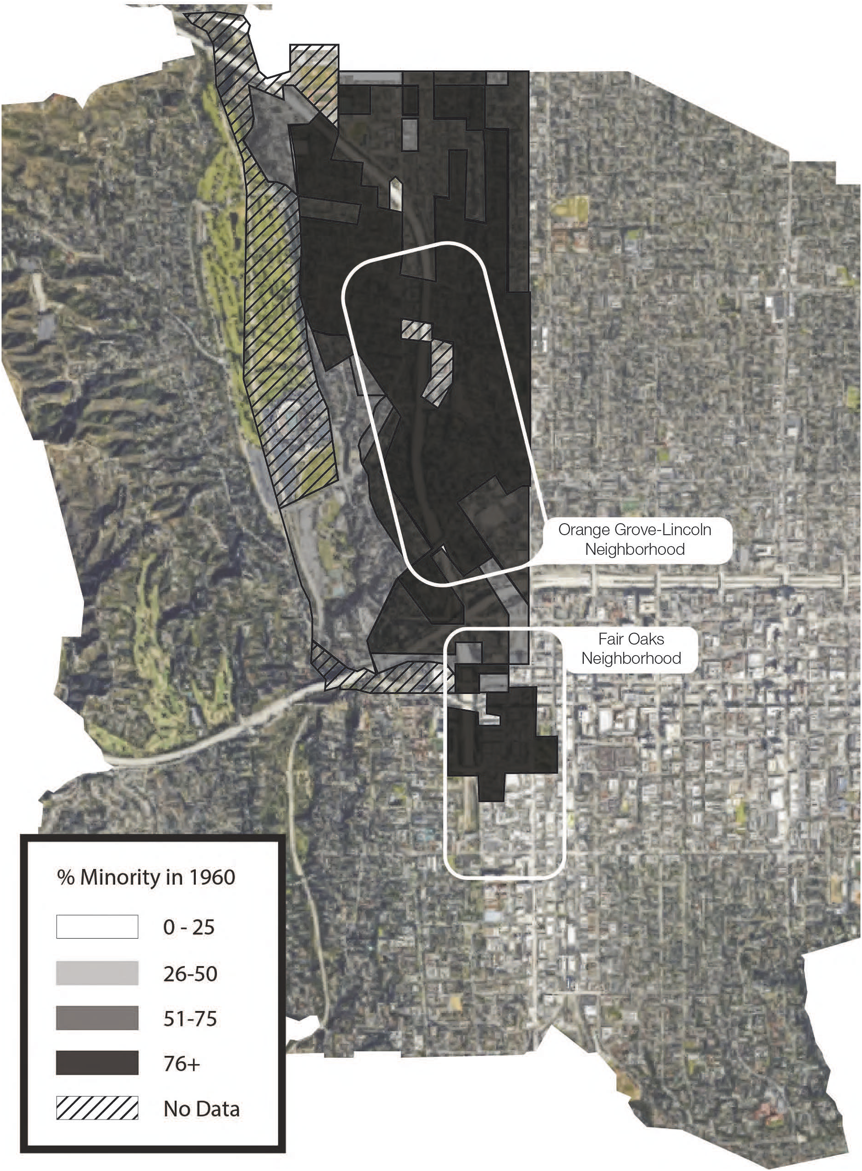
Siting the Freeways
Owing to the war effort and postwar economic boom, many manufacturing and technology jobs had come to Pasadena in the middle of the twentieth century. Several civic leaders believed a freeway would also improve commerce by connecting Pasadena to the rest of the Los Angeles basin.
48
Indeed, Pasadena was a key location in regional plans for a continuous, interconnected freeway network. The city lay at the confluence of three proposed freeways: the Long Beach Freeway/Interstate 710, the Colorado Freeway (part of which was later renamed the Ventura Freeway)/State Route 134, and the Foothill Freeway/I-210. These routes were intended to form a cross that met in western Pasadena (Figure 3). At the top of this cross was the northern spur of the Foothill Freeway, which would bisect and forever alter northwest Pasadena’s communities of color. Pasadena Freeway Intersection. Graphic by authors; base imagery: Google.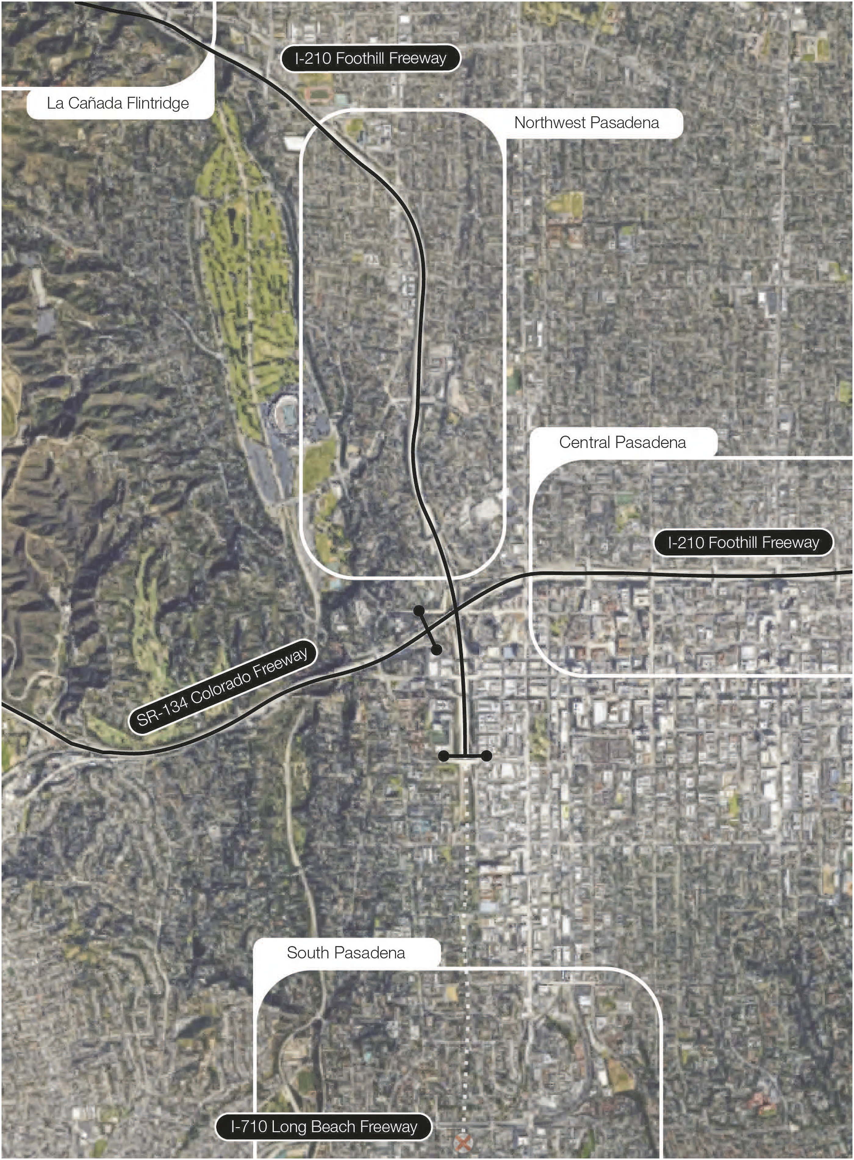
The Pasadena city government chose to locate the northern spur of I-210 through northwest Pasadena in tandem with, and as a component of, their urban renewal program. However, this process took decades. The first published reference to the Foothill Freeway through the City of Pasadena is in the 1943 report Freeways for the Region by the Los Angeles County Regional Planning Commission. 49 It would take another 20 years from that initial report until right-of-way purchasing for the freeway began in earnest and another 12 years until freeway completion in 1975. 50
When planners presented the Foothill Freeway to the public, they included various possible routes but ultimately chose the most destructive route though northwest Pasadena. This decision aligned with decades of racialized planning and urban renewal. Indeed, a quarter-century before the Foothill Freeway bisected northwest Pasadena, its neighborhoods had been deemed “hazardous” and redlined by the Home Owners Loan Corporation (HOLC), as shown in the 1935–1940 HOLC maps of Pasadena (Figure 4).
51
Redlined Areas in Pasadena. Source: Robert K. Nelson, LaDale Winling, Richard Marciano, and Nathan Connolly, “Mapping Inequality: Redlining in New Deal America,” ed. Robert K. Nelson and Nathaniel Ayers, Digital Scholarship Lab, 2023, https://dsl.richmond.edu/panorama/redlining/; lines indicating future freeways added by authors.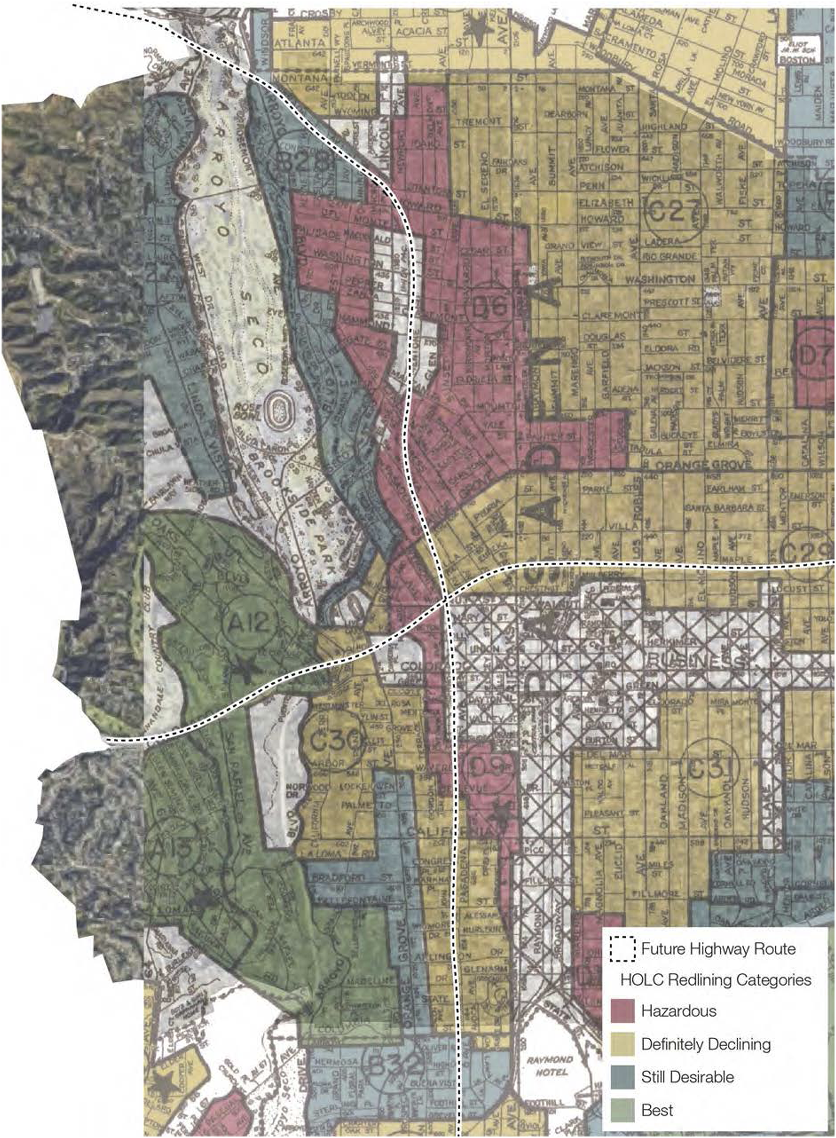
Following the 1948 Housing Act that allocated federal funds for redevelopment, Pasadena designated its first urban renewal initiative (the Pepper Project). This decision was met with opposition from residents. The city’s redevelopment agency hired Black staff to ease racial tensions but then proceeded with the clearance of hundreds of residential and commercial structures in an area previously home to 94 percent non-white residents.
52
In 1955, a few years before the freeway planning process in Pasadena began, the city’s Planning Commission employed again urban renewal to designate the Fair Oaks and Orange Grove-Lincoln neighborhoods for redevelopment.
53
According to a California Eagle article: [Black] Residents of this city girded themselves for an all-out battle to forestall what they charge is a scheme to turn over to private industry one of the largest Negro residential areas and to squeeze its residents into another smaller section of the city also heavily populated by Negroes and members of minority groups.
54
The 1955 urban renewal schemes, reiterated in the city’s 1962 General Plan, changed zoning in the Fair Oaks neighborhood to industrial and displaced its residents. Many of the 2,348 residents were expected to move to the already non-white Orange Grove-Lincoln area, and the northern spur of the Foothill Freeway was slated to run through both neighborhoods. As early as 1955, Black civic leaders were talking about this planned freeway. According to Charles B. Johnson, then president of the Pasadena chapter of the NAACP, freeway construction was estimated to commandeer 15 acres of the 32-acre Orange Grove-Lincoln Neighborhood.
55
He noted the overcrowding that would result: The remaining 17 acres would then have to accommodate most of the 1,233 persons who already live there and another 1200 to 1500 people pushed out of the S. Fair Oaks district. Homeowners would have to stand for re-zoning of their properties from R-1, single family use, to R-4, apartment house use.
56
In 1962, the City of Pasadena published a new general plan which designated areas for urban renewal that closely matched those redlined by the HOLC. 57 Though these neighborhoods were considered “blighted,” the same document described their housing stock as “in good to fair condition.” 58 A former neighborhood resident, Bob Gonzalez, agreed with this description, recalling that the neighborhood had “some of the city's highest concentration of classic Victorian and craftsman style architecture, [which were] within walking distance of local stores, the downtown business district and the city’s Civic Center.” 59
The General Plan did not mention any other routing alternatives, nor did it consider the possibility of building nothing at all. Rather, it presented the “proposed” route as a reality, reinforcing its place in the neighborhood’s future. The dotted line for the northern spur of I-210 cut through the most densely populated area of the city, splitting a residential area in half. In other, whiter parts of the city (Figure 5), planners were careful not to divide residential neighborhoods.
60
The freeway that ensued was built almost exactly as proposed in the General Plan, and the city’s designation of northwest Pasadena as blighted and primed for urban renewal eased the condemnation of land needed for its construction. Pasadena Zoning Map Showing Proposed Freeway and Residential Neighborhoods. Source: Pasadena Planning Commission, “General Plan” (Pasadena, CA: City of Pasadena, 1962); black circles added by authors to show non-white residential neighborhoods. The white circle added by authors shows a white residential neighborhood that appears split by the freeway, but an existing railroad already separated this community. Additionally, in this location, the freeway is submerged.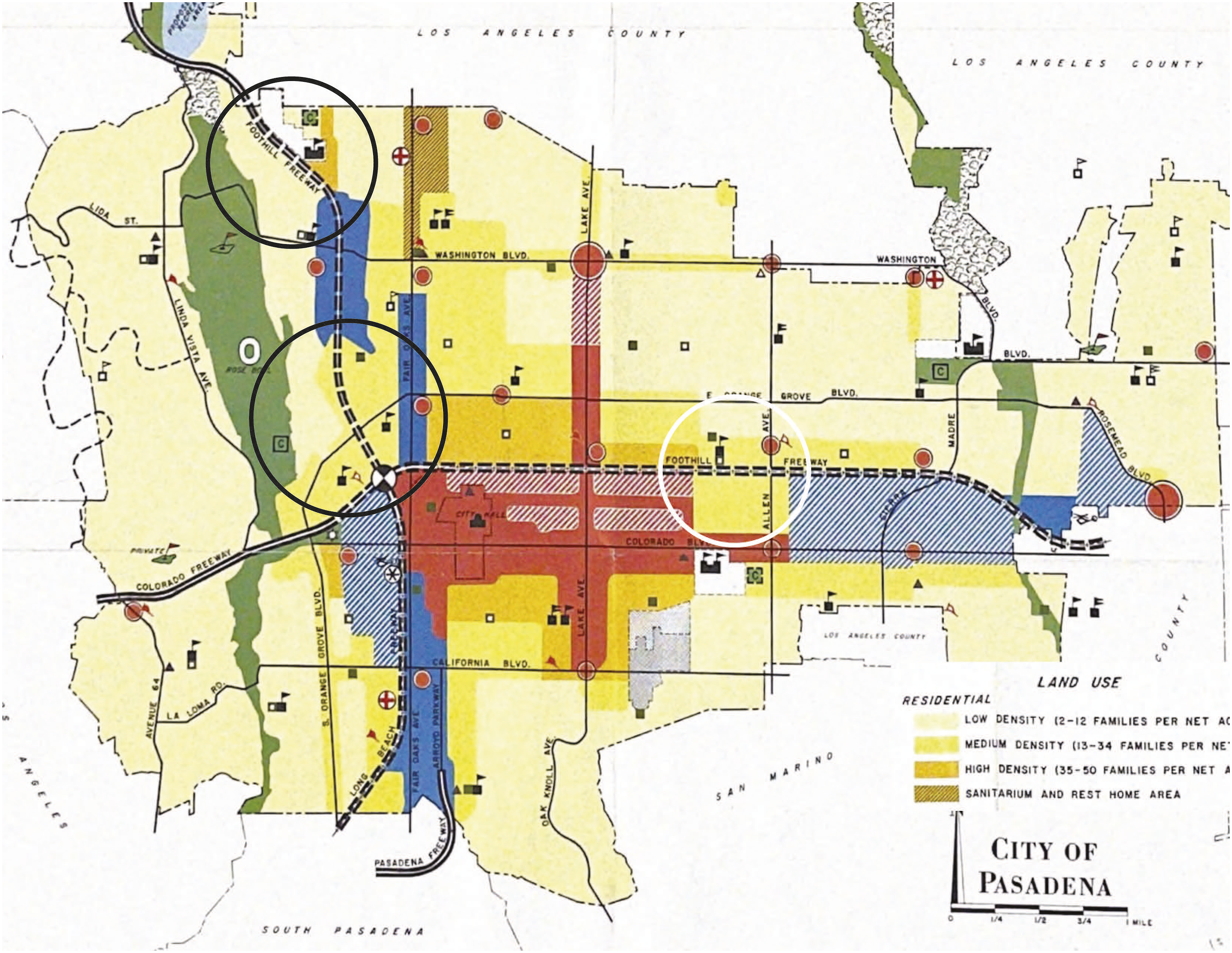
Freeway Routing Options
Public discussions regarding freeway routing options and construction plans across Pasadena began in 1958 and were met with resident skepticism. In July 1958, an estimated 1,400 people packed the Pasadena City College auditorium for a public hearing about proposed Foothill Freeway routing options through central Pasadena (for the eastern leg of I-210 (Figure 3)). Attendees expressed concerns about impacts on property values, disruption of local business, and quality of life. In response, highway engineers warned of dramatic congestion, emphasizing the necessity for a modern highway to handle the increasing traffic, and argued that the freeway was unavoidable as part of a larger regional network. 61
According to newspaper reports from the time, meetings to discuss freeway routes were well attended. Many attendees wore badges identifying themselves as “freeway fighters.”
62
But the audience did not reflect Pasadena’s population diversity; photographs show entirely white audiences (Figure 6).
63
I-210 Freeway Public Hearing. Source: Los Angeles Herald Examiner, Foothill Freeway Hearing, May 10, 1966, photograph, Herald Examiner Collection, Los Angeles Public Library Photo Collection, https://tessa.lapl.org/cdm/ref/collection/photos/id/23554.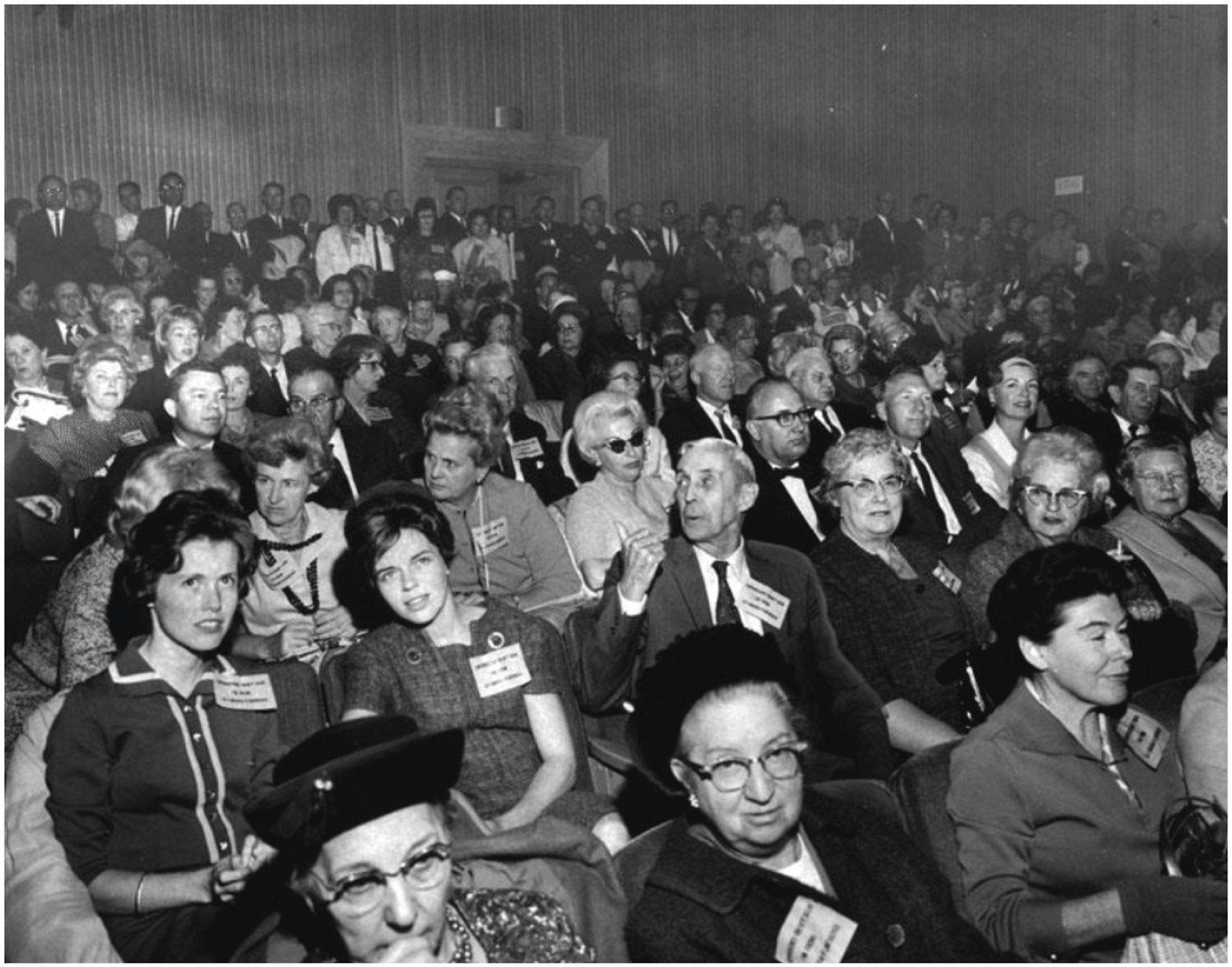
While Pasadenans were unable to stop the construction of the freeway outright, the residents who attended these meetings were able to voice their concerns regarding the siting of the freeway through their neighborhoods. Arguing that other routes would be incompatible with “community values,” central Pasadena residents successfully advocated for a more expensive route for the eastern leg of I-210, which was eventually submerged to avoid bisecting residential zones. 64
Meanwhile, the voices of Pasadenans of color were rarely heard or recorded. In articles chronicling routing decisions in white central Pasadena, as well as nearby La Cañada Flintridge and South Pasadena, published accounts directly quote residents and business owners. But when discussing freeway routing in largely Black northwest Pasadena, communities and civic leaders in La Cañada Flintridge, South Pasadena, and El Sereno were often quoted instead.
State engineers did consider other routing options for the section of the interstate through northwest Pasadena (Figure 7), including a “Blue route” running largely through parkland along the eastern edge of the Arroyo Seco, a “Green route” bisecting northwest Pasadena’s non-white neighborhoods, an otherwise identical version of the “Green route” that took a more direct “Red” cut-off in its southern portion, and an “Alternate route” (shown in white in Figure 7) that combined parts of each of the above routes.
65
Foothill Freeway Northern Spur in Pasadena: Alternative Routing Options. Graphic by authors; data sources: calculated by Ong, Pech, Fitzgibbon, and UCLA Center for Neighborhood Knowledge team in Loukaitou-Sideris et al., “Implications of Freeway Siting” from 1960 U.S. Census (U.S. Census Bureau, “U.S. Census of Housing: 1960”); Ray Hebert, “Pasadena Area Girds for Battle of Freeway: Extension Route Stirs Differences,” Los Angeles Times, May 4, 1964, https://www.proquest.com/hnplatimes/docview/168591343; base imagery: Google.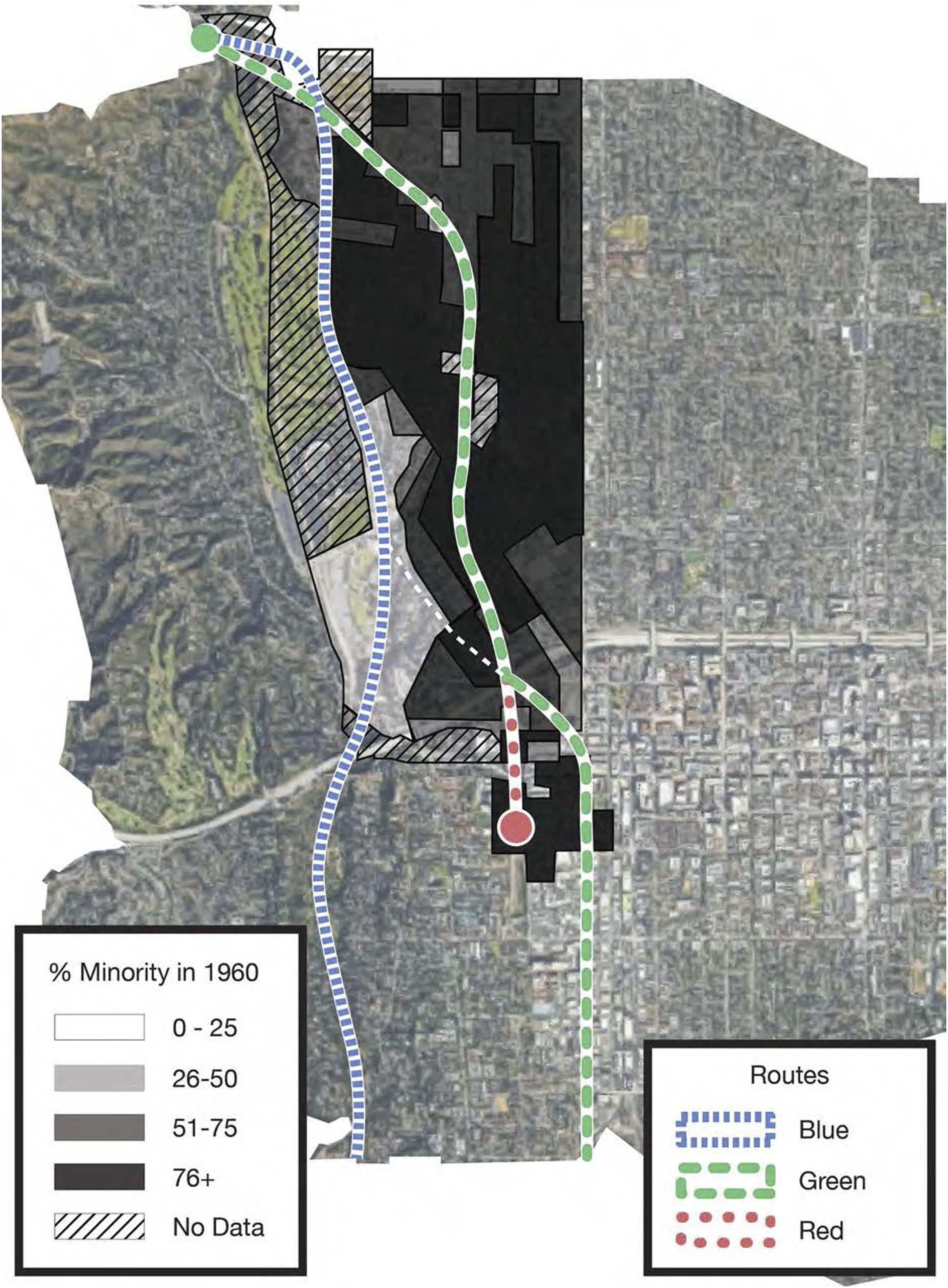
Pasadena officials saw the Green route as the only feasible option, and by 1964, other state officials were wholeheartedly embracing it. According to State Assemblyman George Danielson, “There is no logical choice except to follow the Green route.” He argued that it would have the greatest benefit for traffic efficiency, users, and “communities concerned.” 66 Furthermore, Pasadena administrators used the previously published General Plan as leverage. A 1964 Los Angeles Times article stated that “if a freeway were to be built, a routing along Fair Oaks Ave.... would conform with the city’s general plan.” 67 Pasadena’s city manager agreed, stating that the Blue route was “unequivocally unacceptable” and that the Green route offered “the highest community values in terms of its effect on land development and the neighborhoods through which it passes.” 68
The main argument against the Blue route was that it would destroy the natural beauty of the Arroyo Seco, home to the famous Rose Bowl stadium. The Pasadena Citizens Committee on Freeways, a group chaired by Pasadena Star News editor Lee Merriman, described the Arroyo Seco [Blue] route as a “relentless monster” that would “destroy for all time the one outstanding natural feature of our city.”
69
However, as shown in Figure 8, the Arroyo’s “natural feature[s]”
70
—and its many stadium parking lots—would have remained largely intact, as the proposed Blue route would have passed along its edge. Proposed Blue Route in Pasadena. Source: Pasadena Planning Commission, “General Plan,” with Blue route drawn by authors.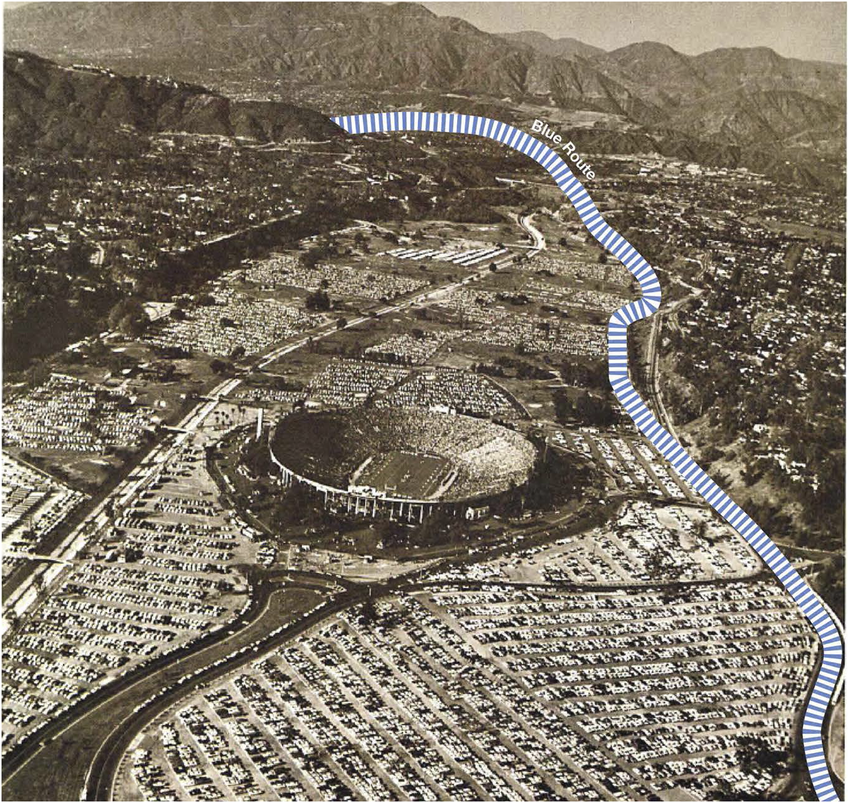
Nearby jurisdictions also weighed in. In a case of strange bedfellows with northwest Pasadena, officials in the relatively affluent and white city of South Pasadena also preferred the Blue route because it would remove fewer housing units in their municipality. 71 Further south, the neighborhood of El Sereno was heavily Latino/a at the time, but in contrast to northwest Pasadena, there is extensive coverage of their interests found in local newspapers. 72 We hypothesize that El Sereno’s alignment with Pasadena’s Green route preference explains the amount of source material we found stemming from this neighborhood of color.
Ultimately, the Green route with the Red cut-off was selected and built. 73 Census data demonstrates that the Blue route would have destroyed almost eight times fewer units of housing, (68 instead of 520), displaced fewer people in total (221 instead of 1,702), and proportionally fewer people of color (54% instead of 76% people of color). 74 Newspapers indicate that residents and public officials were familiar with arguments outlining the harm and injustices associated with freeway plans, 75 yet policymakers and highway planners ignored their inequitable impact all the same.
Freeway Impacts
Freeway development in northwest Pasadena represents a self-reinforcing cycle: the same neighborhoods were initially denied federal mortgage support, then slated for urban renewal, and finally selected for freeway construction. The northern spur of the Foothill Freeway displaced 2,600 to 2,700 people in Pasadena across its full length, of which two-thirds were people of color. 76
The confluence of urban renewal and freeway planning depressed land values in northwest Pasadena, dropping them even more following Pasadena’s rejection of all other routes as “unequivocally unacceptable” in May 1964. 77 Those whose properties were condemned for freeway construction were reimbursed according to “fair market values,” but by 1960 their home values were already only 68 percent of the Pasadena average. 78 Homeowners who were spared from the freeway’s path still suffered detrimental economic and health outcomes and saw their home values drop further relative to the city’s overall. These outcomes entrenched existing structural inequities even for those who kept their homes. 79 The dangers to human health posed by freeway proximity were widely known by 1970, when the California legislature added a statute restricting siting of new schools within 500 feet of a freeway, but construction through residential northwest Pasadena continued nonetheless. 80
While communities of color in central-city neighborhoods opposed freeway construction, in Pasadena they seemed helpless in the face of decision-making processes. Even some locally active white Pasadenans saw opposing the freeway altogether as “impractical and impossible to stop.” 81 Former resident Bob Gonzalez stated that residents of color felt powerless: “We couldn't fight city hall.” 82 The exact reason as to why resistance among people of color was not recorded in Pasadena remains unclear, but our findings reveal an absence of their voices in planning meetings and an extreme dearth of reporting of their concerns. Seeing the past failures of organizing among residents of color against government projects in Los Angeles may have contributed to a sense of resignation. While residents of color in Chavez Ravine fought to keep their homes, they failed to stop the urban renewal machine in the 1950s. Similarly, residents of color opposed freeway construction in Boyle Heights and West Adams (1950s–1960s) but failed to stop the freeways. According to former resident Gonzalez, “Well, you know what happened at Chavez Ravine? See? The government. The city. Money. We couldn’t do nothing.” 83
In contrast to the apparent resigned acceptance of these residents, freeway boosterism by governmental and monied interests in central Pasadena continued ever louder throughout the freeway’s construction, as reflected in a Los Angeles Times article from 1971: Communities along the route of the Foothill Freeway are looking eagerly to its completion in 1975 despite a few trepidations. They see increased opportunities for business as the freeway creates greater accessibility; a higher degree of mobility and population growth. And in the case of Pasadena, which is most fervid in pinning its hopes on the freeway, there are dreams of becoming an important headquarters city for national firms.
84
Comparison to Nearby Areas
In the wealthy, white La Cañada Flintridge, just northwest of our study area, residents pushed back against construction of the Foothill Freeway through their neighborhood. They protested elevated freeways that would generate acute noise pollution and lobbied for a multi-year construction delay. Some of their public officials even threatened to refuse signing any street closure agreements required for construction. 85 Even though they did not avoid the freeway entirely, they won design concessions and successfully delayed construction, allowing the alteration of the freeway route to minimize housing impact from the originally proposed 2,069 homes to the finally demolished 1,397. 86 Furthermore, the built freeway was submerged in the central business district and partially covered by a landscaped platform—the only freeway cap in Greater Los Angeles—making it less intrusive.
Just to the east of the northwestern spur, the City of Pasadena listened to its white residents and re-routed I-210 in central Pasadena away from the initially planned route south of Colorado Boulevard. The city reasoned that such a route would “destroy hundreds of … attractive residences,” and that displaced people “would be unable to relocate in Pasadena.” They also argued that it would “cut off many north and south streets,” creating “a blighted area between Colorado and the freeway, where no one will care to own a home.” 87 Almost identical arguments could have been made against the northern I-210 spur through communities of color, yet that alignment proceeded as planned.
Some neighborhoods near Pasadena managed to prevent freeway construction entirely. Residents in South Pasadena organized to block the extension of the Long Beach Freeway through their community. They had protested freeway routing earlier in the planning process, supporting the failed Blue route, and their anti-freeway objections became louder once the I-710 extension through their neighborhood was being directly discussed. In the 1960 census, South Pasadena was 99 percent white, 88 and their city council appointed a “Freeway Commission” that vocally opposed freeway construction. 89 Their efforts were so successful that the link was never completed: in 2017, South Pasadena residents stopped a last proposal to construct this final leg of the freeway as an underground tunnel. 90
Lasting Effects
Beginning in 1971, clearance of land (Figure 9) and the construction of I-210 proceeded in different segments, with the final spur opening to much fanfare on March 20, 1976.
91
Pasadena’s non-white neighborhoods had been identified as blighted and then rationalized by Pasadena’s General Plan as the optimal location for urban renewal and freeway construction. Underrepresented in planning meetings and decision-making, Pasadena’s non-white residents had their fate sealed decades in advance of construction. The freeway displaced many, and those who remained faced increased environmental degradation and suppressed land values. Cleared Land for Freeway Construction. Source: 210 Construction at Fair Oaks Ave. (1972), 1972, photograph, NAACP Pasadena Branch, izi.TRAVEL, https://izi.travel/en/c2e9-walking-tour-of-the-african-american-history-of-pasadena/en.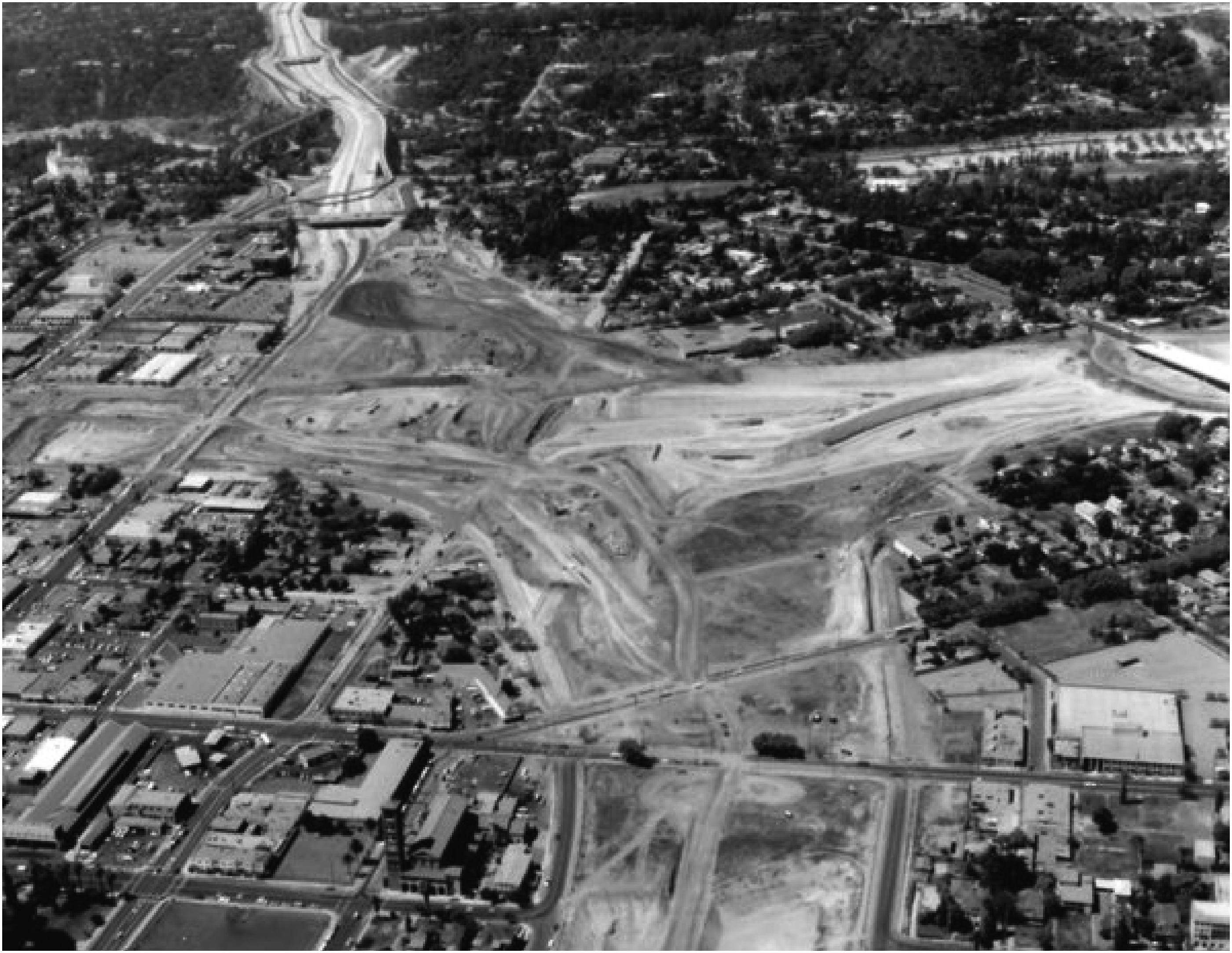
While communities in central Pasadena, La Cañada Flintridge, and South Pasadena won various concessions, the I-210 was built through northwest Pasadena with no mitigation strategies. We see the silence of voices from northwest Pasadena as suggestive of exclusion from participatory processes and evidence of alienation from the public and civic discourse surrounding freeway planning. Such stark contrasts live on, divided by design, and calcified in today’s freeway maps (Figure 10). Northwest Pasadena before and after the Freeway. Sources: A Dense Street Network Connected Neighborhoods in NW Pasadena to the City’s Commercial West Side Prior to the 210 Freeway., photograph, NAACP Pasadena Branch, izi.TRAVEL, https://izi.travel/en/c2e9-walking-tour-of-the-african-american-history-of-pasadena/en; Google.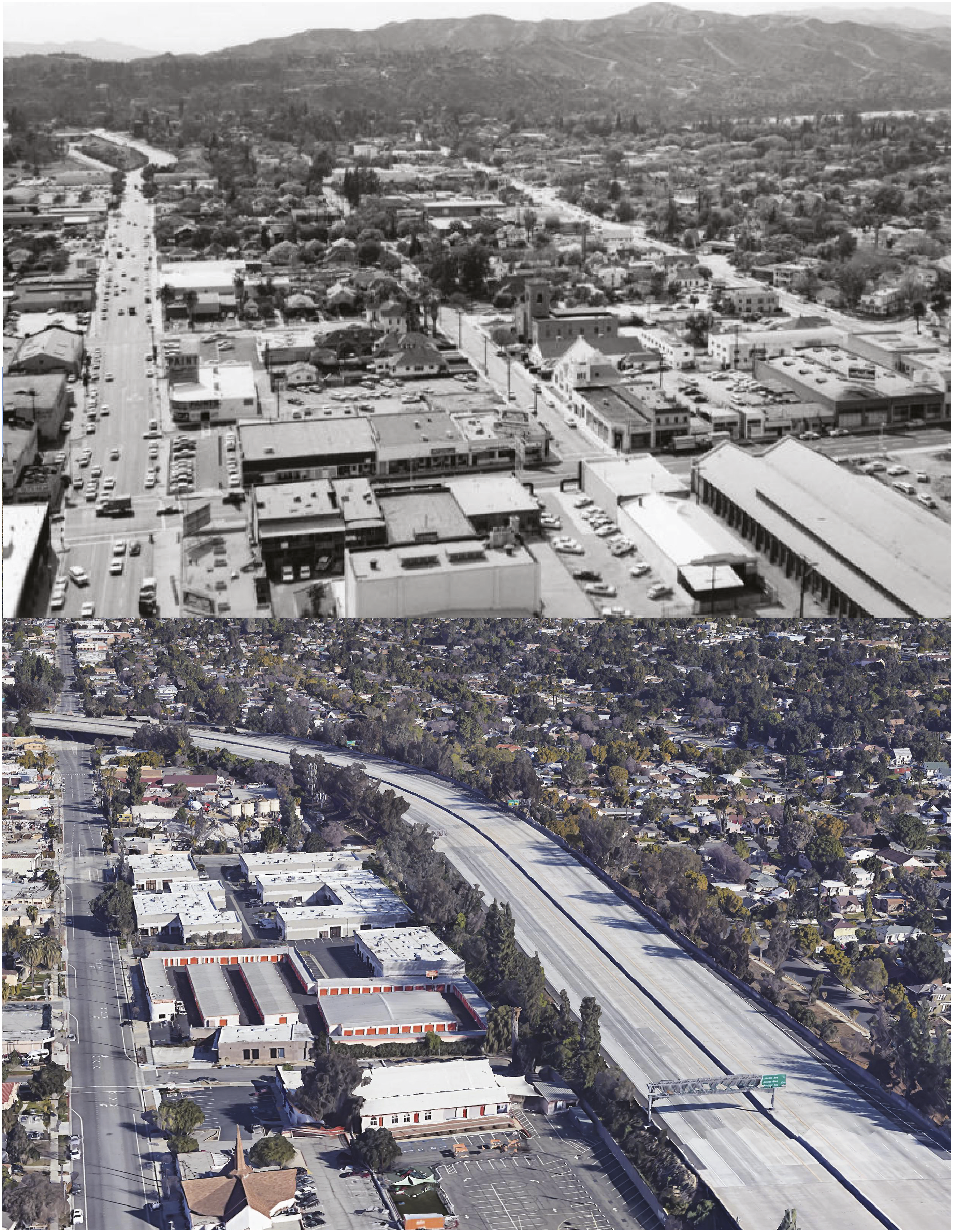
Pacoima
If northwest Pasadena was sliced by one freeway, Pacoima was minced by three. Pacoima is a low-income, predominantly Hispanic neighborhood in Los Angeles’ San Fernando Valley, to the north of the Los Angeles Basin. After the construction of three different freeways through the neighborhood in the 1960s and 1970s (Figure 11), Pacoima residents faced disproportionate environmental and health disadvantages. Freeway Siting in Pacoima. Graphic by authors; base imagery: Google.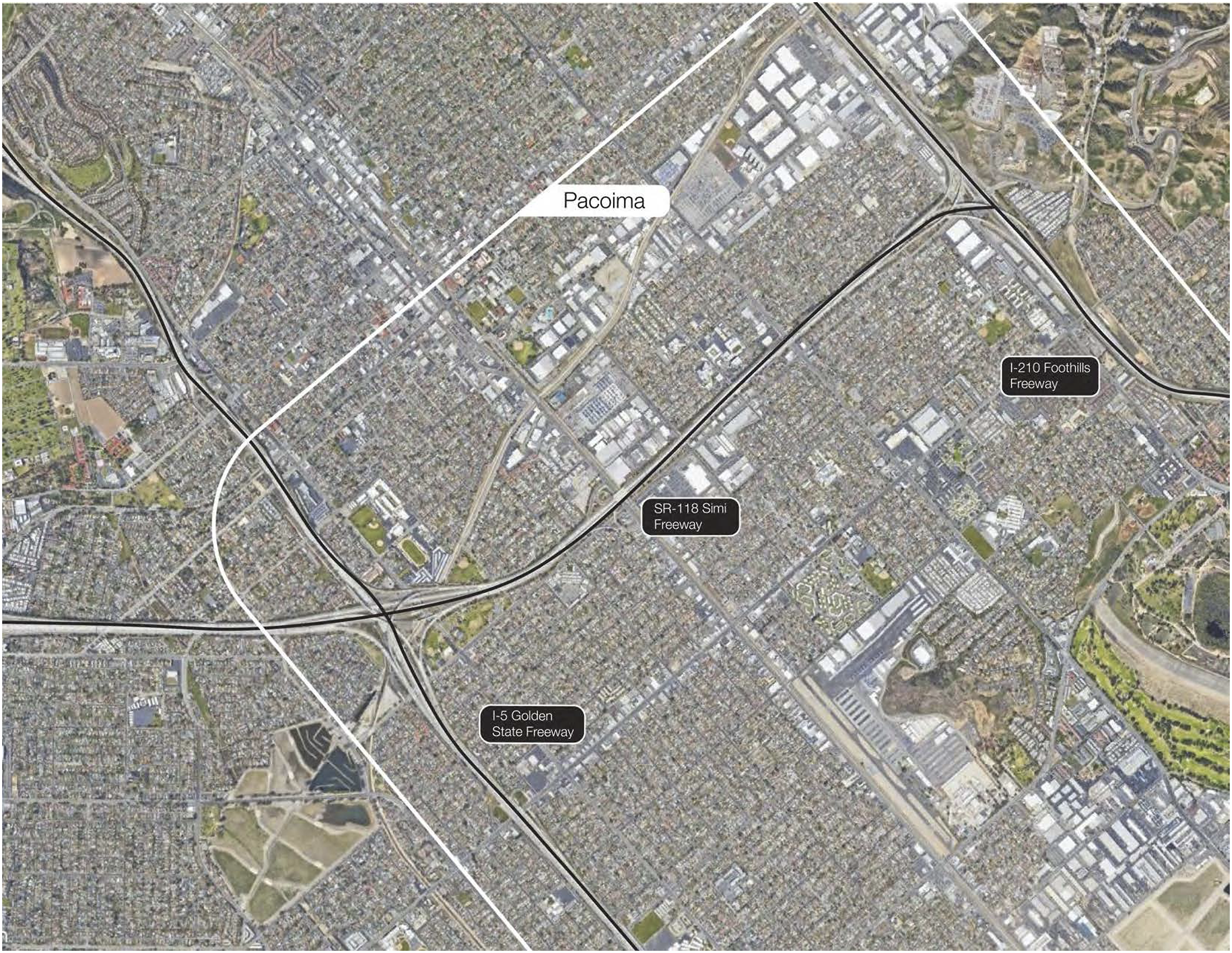
The Golden State Freeway/Interstate 5 was the first freeway to reach the northern San Fernando Valley and one of the final segments of the freeway from downtown Los Angeles through the Valley. When the route was chosen in 1953, 92 it faced opposition from non-white groups in East Los Angeles, at the other end of the route from Pacoima. 93 Nevertheless, construction began, and the freeway was open to traffic in 1963. 94 The Foothill Freeway/I-210—the same one driven through Pasadena’s neighborhoods of color—also extended to Pacoima. This five-mile stretch was part of the final northern section between the Valley and the Inland Empire to the southeast. 95 Studies for the Simi Freeway/SR-118 began in 1956, but the final route was completed in 1979, after several delays. 96 Though relatively small, these segments in Pacoima were crucial in connecting the greater metropolitan region to a growing system of highways across the state and country.
Unlike Pasadena, which dates to the late nineteenth century, Pacoima was relatively undeveloped and agricultural until the 1950s. During this decade, the San Fernando Valley experienced an unprecedented population boom, but housing opportunities were not open to all. As in Pasadena, the HOLC map of Pacoima clearly delineated areas effectively closed to people of color (Figure 12). The center of the neighborhood was redlined, while the rest was not developed enough to be rated. Redlining was widespread across the Valley, and most non-whites could not get a mortgage to acquire a home. Even after Shelley v. Kramer in 1948 ruled racial covenants as unconstitutional, segregation continued. According to the San Fernando Valley Fair Housing Council, between 1950 and 1960 only one Black family managed to find a home in a white region of 750,000 residents.
97
Pacoima was the only neighborhood in the Valley where non-white individuals could acquire property, lease, and occupy homes. Yet, even after a 1959 law made it illegal for all businesses (including real estate brokers) to discriminate on racial grounds, real estate agents continued to find ways around it.
98
Crystal Jackson, President of the Pacoima Historical Society and author of The Entrance: Pacoima’s Story, points out that Pacoima and Watts were the only two areas in the entire City of Los Angeles that accepted GI loans from colored people at the time.
99
Residents recalled that the area was surrounded by more affluent, white neighbors, who lived in more expensive housing.
100
Redlined Areas in Pacoima. Source: Nelson et al., “Mapping Inequality”; lines indicating future freeways added by authors.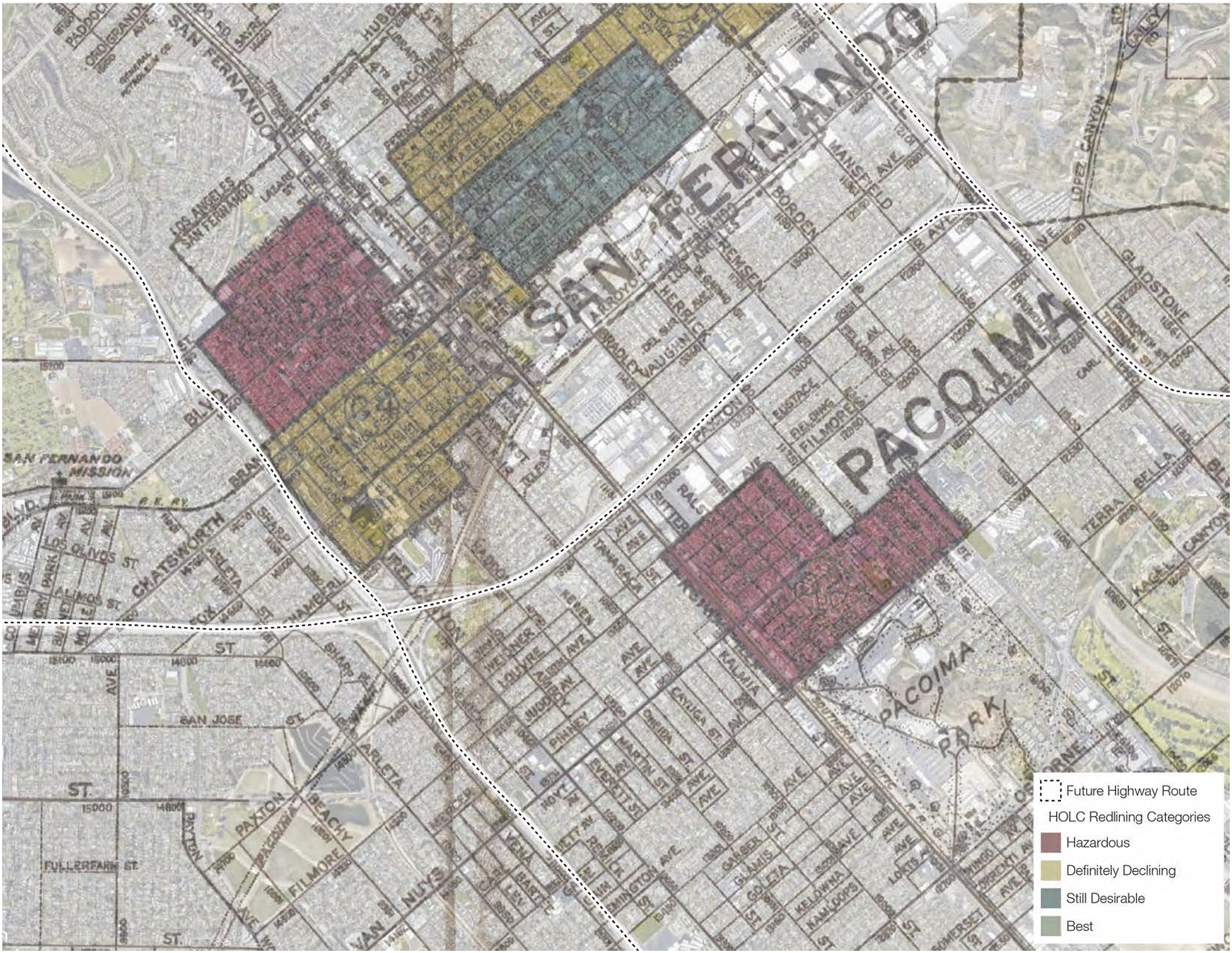
According to census data, before the freeways were built, around 40 percent of Pacoima residents were Black and 26 percent Latino/a. 101 The area was also home to an Asian American community. Former resident Nancy Takayama recalls that “when the Japanese came to live here in the San Fernando Valley, no one would sell them land outside of Pacoima.” 102 On the other side of San Fernando Road, the population was mostly Black. One resident recalled, “It was like a little United Nations on that block....It was African American, Filipino, Hispanic, white, Asian...and that was the beauty of the community.” 103 Mary Helen Ponce’s autobiography Hoyt Street offers insight into “Pacas” (Pacoima) as a place that welcomed Mexican immigrants, white folks, Black ex-GIs, and day laborers. Despite its unique multi-ethnic composition, Pacoima was surrounded by “San Fernando Valley’s intentionally structured white supremacy.” 104
Pacoima experienced a large housing boom during the 1950s. In April 1956, the Los Angeles Sentinel reported 105 that the price of land in one development, Pacoima Park Estates, was soaring. Pacoima’s median income in 1960 was 86 percent of the City of Los Angeles’ and 74 percent of the San Fernando Valley’s. The press coined Pacoima “the heart of the thriving San Fernando Valley” and “the world’s fastest growing residential area.” 106 But unlike most suburbs of the time, a significant amount of housing built in Pacoima throughout the 1950s was designed to appeal to Black residents. 107 The California Eagle consistently ran advertisements for housing projects there, inviting readers to attend free Sunday brunches at a furnished model home. 108 One development, Joe Louis Homes, borrowed the name of the Black heavyweight boxing champion to attract Black residents (though he had no relationship with the project). 109
Freeway Planning and Alternative Routes
Pacoima residents may have not welcomed freeways, but we found no evidence that they were able to actively contest them. Voices from this racially diverse community are notably absent from newspapers, planning documents, and historical archives that discuss freeway planning and construction efforts. This silence suggests that Pacoima’s residents were likely alienated from public opinion and civic discourse. As in Pasadena, Pacoima’s wealthier, white neighbors had greater influence over freeway siting. In 1961, white residents of South Arleta, next door to Pacoima, protested street closures for the construction of the Golden State Freeway, which would lock them in a “20-block island,” cut off from major access routes (Figure 13).
110
But the most significant freeway revolt in the Valley arose against the Simi Freeway to the west of Pacoima. South Arleta Residents Protest against Freeway Construction in 1961. Source: Pacoima Street Blockade Protested, 1961, photograph, Valley Times Collection, Los Angeles Public Library Photo Collection, https://tessa.lapl.org/cdm/singleitem/collection/photos/id/41172/.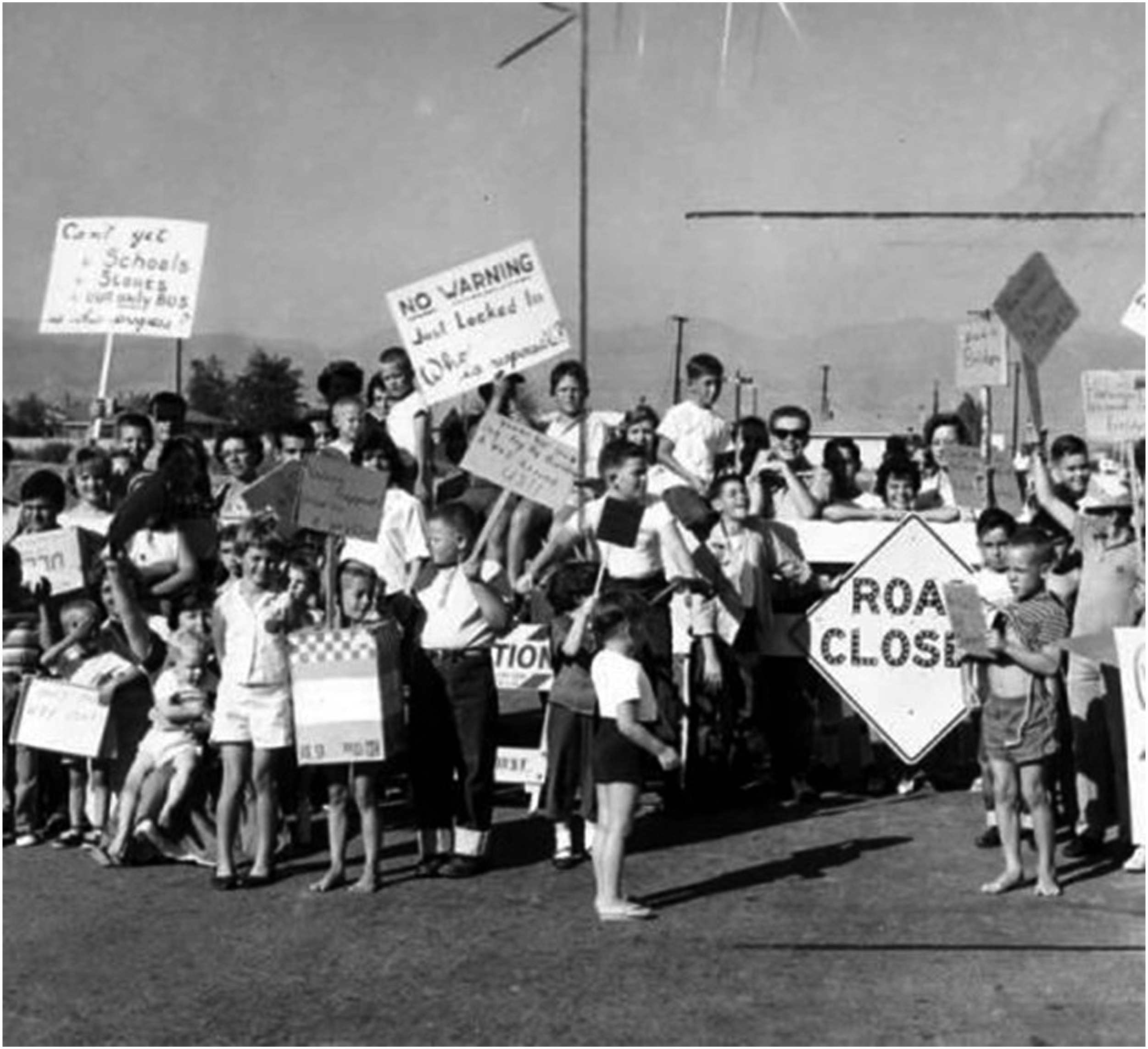
In 1960, the Valley-wide Committee on Streets and Highways and Transportation began collaborating with local industrial associations, chambers of commerce and planning commissions to study possible pathways for the Simi Freeway and corresponding right-of-way purchases.
111
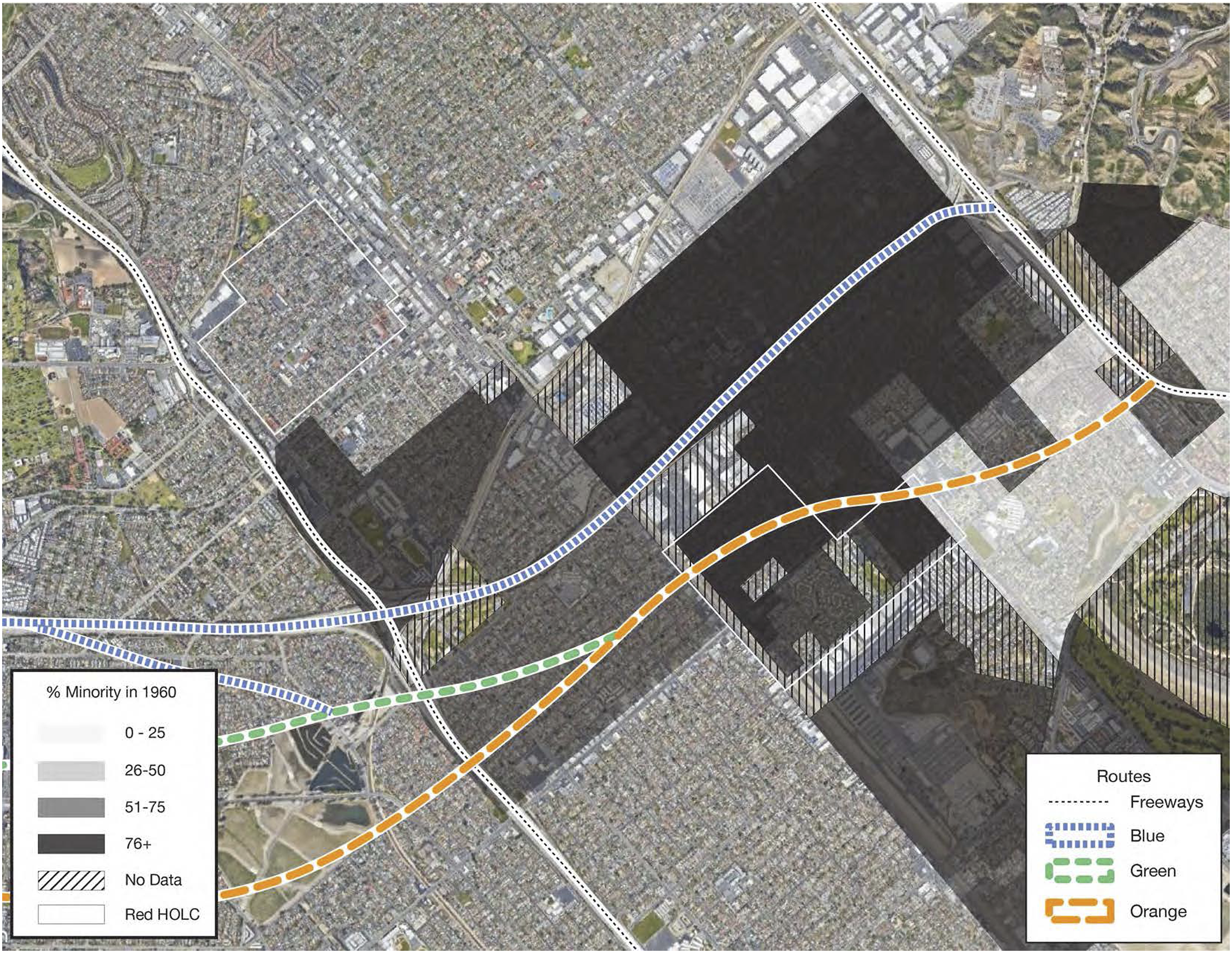
While there was widespread agreement that the freeway across the Valley was necessary, communities in Chatsworth, Granada Hills, Mission Hills, and Northridge all opposed building it through their neighborhoods. By 1963, local civic organizations were loudly voicing their position and advocating for their perceived best interests. As a result, the state’s Division of Highways presented four different routes, also color-coded: Orange, Green, Blue, and Red (Figures 14 and 15). Routing Alternatives in Pacoima and the San Fernando Valley. Graphic by authors; base imagery: Google. Population Distribution of Pacoima Residents of Color in 1960, with Superimposed Routes. Graphic by authors; data source: calculated by Ong, Pech, Fitzgibbon, and UCLA Center for Neighborhood Knowledge team in Loukaitou-Sideris et al., “Implications of Freeway Siting” from 1960 U.S. Census (U.S. Census Bureau, “U.S. Census of Housing: 1960; City Blocks: Los Angeles, Calif.,” ed. Wayne F. Daugherty (Washington, D.C.: U.S. Census Bureau, 1961), https://hdl.handle.net/2027/uc1.d0001533710); Nelson et al., “Mapping Inequality”; base imagery: Google.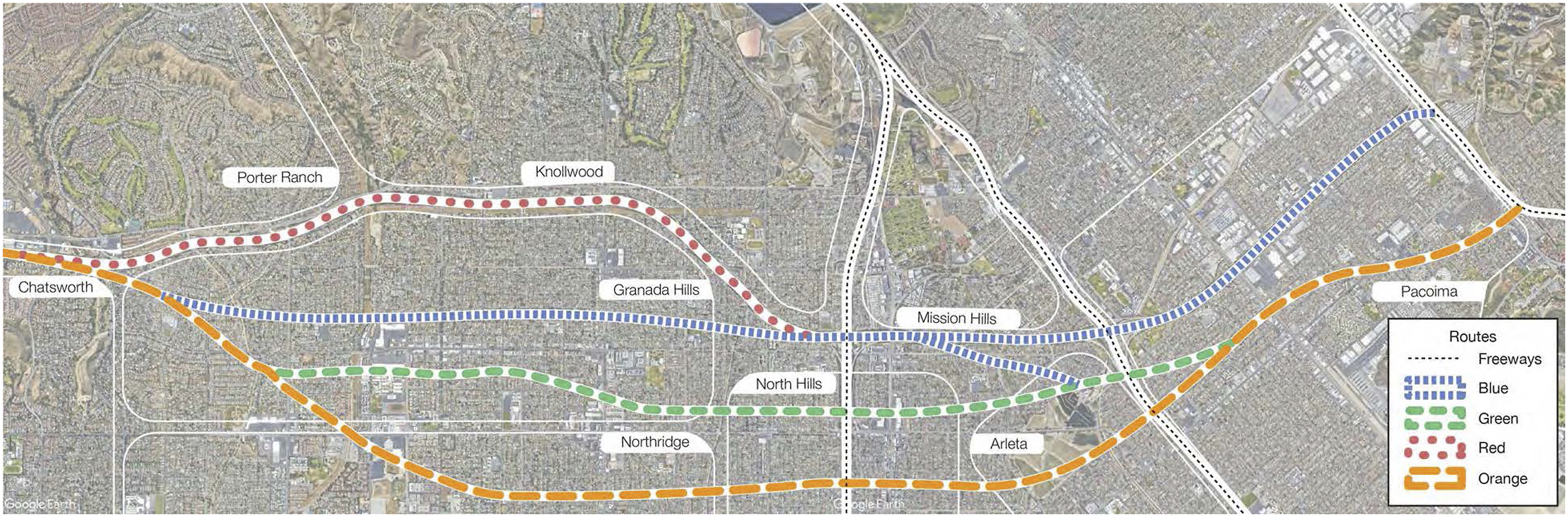
The Valley State College (today, CSUN) and the Northridge Chamber of Commerce joined forces in favor of the northern (Red) route. They adamantly opposed the southern (Orange) route, as it would damage the development of the college and complicate its existing campus masterplan. The Homeowners Freeway Committee, along with the chambers of commerce of Granada Hills, Mission Hills, and Sepulveda favored the southern (Orange) route, which would spare their residential neighborhoods.
112
Mission Hills residents condemned the Red route because it would create a “Chinese Wall” around their neighborhood.
113
Local newspapers reported extensively on the “showdown battle,” and correspondence among the organizations’ leadership demonstrates the importance of the matter (Figure 16).
114
All the while, the different routing options would have different effects on Pacoima at their eastern end, which remained unremarked. Anti-freeway Protest Meeting of Valley Homeowners, to the West of Pacoima. Source: Gordon Dean, Clear Indication, July 1, 1965, photograph, Valley Times Collection, Los Angeles Public Library Photo Collection, https://tessa.lapl.org/cdm/ref/collection/photos/id/59567.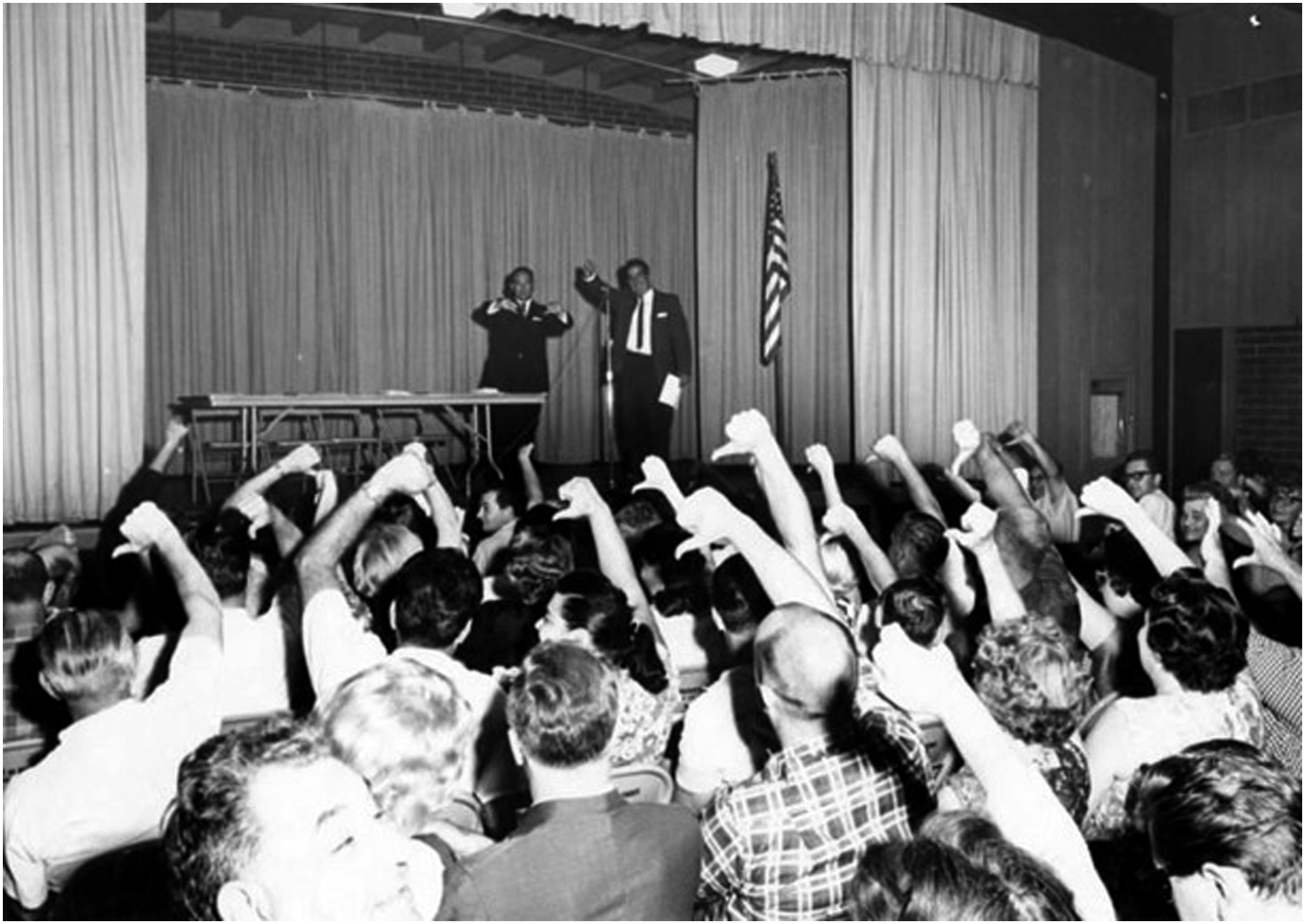
State officials presented the four routes to the public to allegedly give local government officials, civic groups, and all individuals an opportunity to express their views. Yet debates about the different routes centered exclusively on the area west of Pacoima, where white residents and business interests received all the press and governmental attention. 115
Over 2,000 citizens attended the hearings in January 1964 at the San Fernando High School auditorium, where representatives from Valley State College, Northridge businesses, and homeowner associations voiced their concerns. Ultimately, a combination of the Blue and Red routes for the Simi Freeway was adopted. The Division of Highways concluded that this routing would affect 174 fewer homes than the other alternatives and cost $2.9 million less. 116 In response, members of the Homeowners Freeway Committee, west of Pacoima, raised funds and hired a private planning consultant to prove otherwise. They promised “surprising new evidence” that the selected route would compromise 1,200 more homes and cost $1 million more than estimated. 117 This evidence, though, was never released, and their efforts proved unsuccessful.
In stark contrast, there was no public discussion about the route that the Division of Highways selected for Pacoima, which spanned four of the eleven miles of the freeway project. Unlike Pasadena, the chosen Blue route displaced somewhat fewer households in Pacoima, but also traversed an area with 36 percent more residents of color than the alternative route Orange to the south. 118 We found no evidence of Pacoima’s civic organizations or non-white residents participating in any of the hearings or opposing the project in the press, interviews, or relevant archives. Unlike their wealthier, predominantly white neighbors to the west, Pacoima residents lacked political clout and economic power to engage in the participatory planning process that took place prior to the route selection in a consequential manner. 119 Indeed, one civic leader remembered growing up in Pacoima after her parents moved to a house on Filmore and Judd streets in 1955. Her mother and their neighbors recall that when SR-118 was built, none of them were ever asked for their opinion. 120
Pacoima residents’ absence from public debates around freeway siting put this neighborhood first on the chopping block. Freeway construction was planned from west to east, initially leaving the section through Pacoima last. However, construction in Pacoima finished in 1973, while communities to the west bickered over the route and delayed construction. In 1973, 13 homeowners in Granada Hills to the west resisted eviction from homes claimed by the state through eminent domain and were given permission by the court to stay for another year. Strong opposition from communities and a lawsuit filed by the National Wildlife Association delayed construction even further. The delay coincided with new federal legislation, which required the completion of an Environmental Impact Report for freeway projects. 121 In 1974, only after the Pacoima segment was well underway, was such a report produced—solely for the segment to the west. 122
Freeway Impacts
Freeway effects on Pacoima were profound. Massive concrete structures replaced farmland, parks, public spaces, commerce, housing, and entire local streets, destroying over 200 housing units and displacing about 800–900 residents, two-thirds of whom were people of color. Freeway construction also slowed down Pacoima’s housing boom; census data indicate a decline in the growth rate of housing units in Pacoima relative to the San Fernando Valley. 123
Even before the Simi Freeway passed through Pacoima, the neighborhood had lost a 40-acre park to the Golden State Freeway, which required 31 acres for a cloverleaf interchange. When the state purchased the area from the Recreation and Park Commission in 1956, the parties agreed to build another park elsewhere in Pacoima. 124 That promise remained unfulfilled. In fact, according to local planning professionals, Pacoima is today among the most deprived Los Angeles neighborhoods in access to green space. 125
Nowhere in Pacoima is the imposing scale of freeways more visible than at San Fernando High School. Prior to the freeways, hundreds of teenage students walked northwest on San Fernando Road and across Paxton Street to get to class. After freeway construction, students could no longer cross the road to reach their school directly but were forced to walk to the closest underpass or through a narrow tunnel that interviewees described as dark and dangerous. 126
Another victim of freeway construction was the Laurel Drive-in Theater (Figure 17). Residents vividly remember construction because “it displaced the only entertainment we all had.”
127
One resident owned a small family market that was replaced by a gas station soon after the freeway was built. When construction on the Simi Freeway commenced in 1970, eminent domain claimed most of those businesses.
128
Aerial Photograph of Laurel Drive-in Site before and after the Freeway. Sources: Laurel Drive-in Aerial Shot, 1964, photograph, Pacoima Historical Society; Google.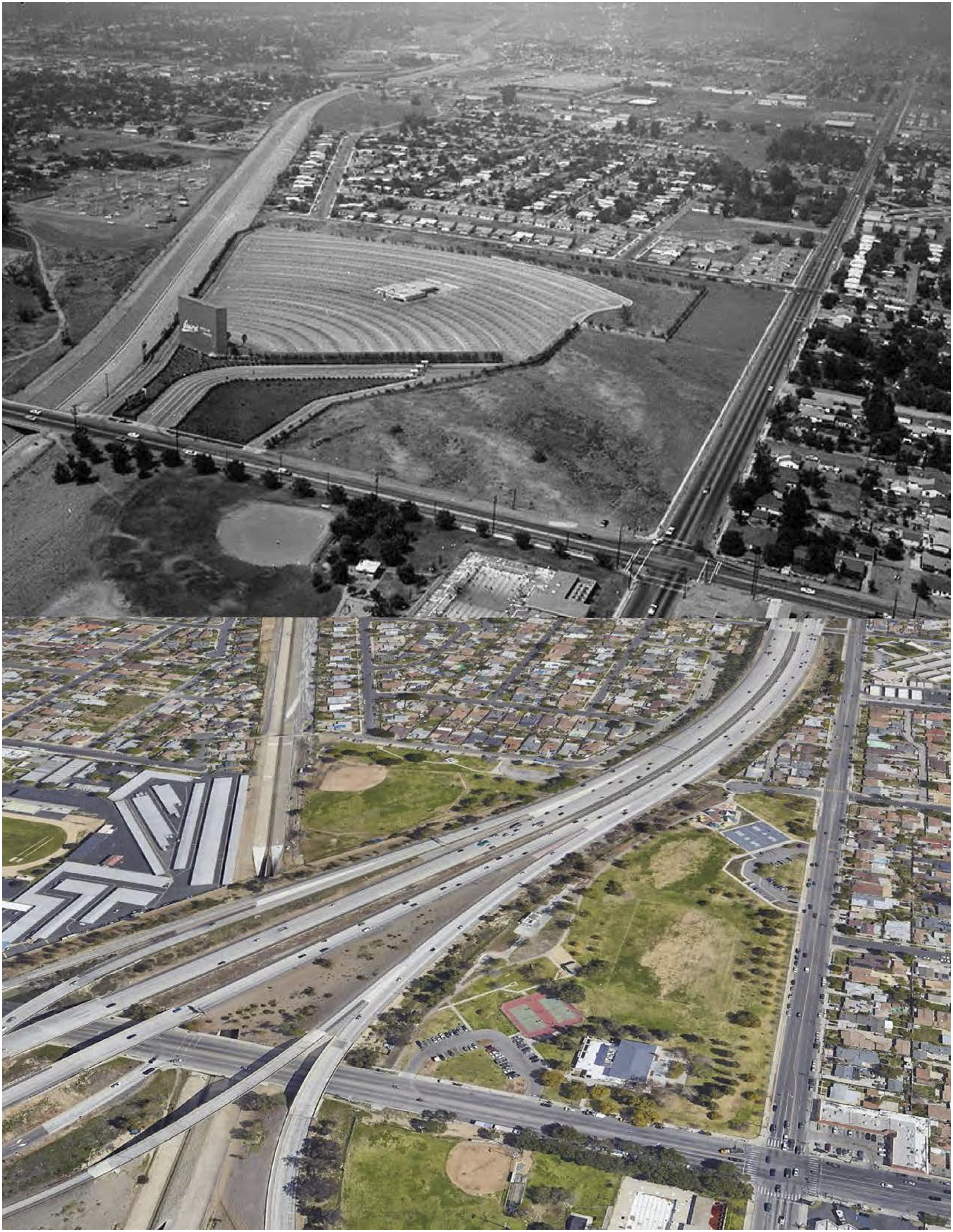
The freeways gobbled up whole streets. Most of Fielding, a three-mile residential street, disappeared. Its homes—most only a decade old—sat in the freeway path and were seized by eminent domain and demolished. Having been absent from public hearings, residents were given a relatively short notice to relocate, and many moved to other neighborhoods. 129 A religious leader recalled that many members of her congregation lived near the church but had to relocate because of freeway construction: “There were sections by the church, where there was house after house, and those houses are gone. Rows and rows of houses between Foothill and San Fernando Road are gone, just gone.” 130
The state compensated homeowners, and in some cases, residents received more than what they had paid a few years earlier. One resident and her family moved to Fielding Street in 1968 and had to relocate in 1971. They were among the last residents displaced. She recalled purchasing their home for $12,950 and receiving $18,500 only three years later. However, finding another home proved difficult and expensive. 131 Many could not afford to relocate in the area, even with the money received from the government. One interviewee recalled that “people didn’t think it was a fair price....Homes were going up, prices were going up, so whatever you got, it wasn’t enough. You were still going to have to get a bigger loan”. 132
Many Black residents could not find nearby alternatives and were forced to look outside Pacoima. A 1966 article in the Los Angeles Times described Valley residents’ varying opinions about right-of-way purchases. One wealthier homeowner whose home and pool were in the route of the freeway was delighted to have the state as a ready-made buyer. But less affluent homeowners lamented the circumstances, as they never intended to move away. “There are cases where individuals lose even though the state pays market value for property,” the Times reported; “One example...is the man who has a low 4.5% GI loan which he won’t be able to get when he buys a replacement.” 133
Residential displacement persisted into the 1970s, as freeway ramps and freeway widening demanded additional space. In 1971, the Times reported that 15 homes would be removed to accommodate changes in freeway plans. At this point, members of the City Planning Commission did raise questions about displacements. Commissioner David Moir complained to the State Division of Highways, “You mean the homes are to be acquired by the state and the people have no idea of it?” The state’s response was merely that they had held “the proper public hearings on the route...some time ago.” 134
Over its course in San Fernando Valley, the Simi Freeway took around 1,500 properties. 135 However, its impact was larger. Citing a real estate broker in 1966, the Times reported that “the people who really suffer are the ones whose homes won’t be bought by the state but will be so close to the noise of the freeway that their property will depreciate badly.” 136
In 1971, when the Los Angeles City Council approved a motion to speed the construction of the Simi Freeway/SR-118, the North Valley Ecology Council (a local environmentalist group) and the Northridge Civic Association objected and called for environmental studies. 137 But because the route was adopted in 1964, it predated the California Environmental Quality Act and National Environmental Policy Act requirements for such review. Not only did Pacoima’s freeways avoid environmental review, but subsequent environmental analyses of initiatives like the Pacoima Community Plan treated them as a given and not subject to mitigation. 138 The environmental impact report for the Pacoima Community Plan in June 1974 announced that the freeways had progressed to the “point of no return,” recognizing that their presence “[would] result in an increase in air pollution and noise levels.” The document noted that the Simi Freeway “already had a direct, irreversible impact on the Community as it [had] cut a 300-foot-wide path across single family residential areas.” 139
Despite the adverse environmental effects, after years of building, residents were growing inpatient to at least see freeway construction completed. A 1972 article paraphrased Edward Kussman, Housing and Community Action Chairman of the Valley NAACP, protesting the living conditions along the freeway routes under construction, whose residents were “plagued by dust blowing into their homes off vacant lots” and “...mounds of dirt piled up along the Simi Valley, Foothill, and Golden State Freeway.” 140 In a letter, Kussman urged the state to complete the freeways, as the area around them had become “unsightly.” Unlike areas to the west, where resident opposition caused delays in construction’s start, Kussman’s letter reveals that in Pacoima, financial challenges delayed SR-118 after building was well underway. He lamented that “the sacrifice made by those who gave up their homes should at least be rewarded with a better area for those who remain. The quality of life should not be lowered for those who cannot move because of economic circumstances.” 141
Lasting Effects
Decades later, the issues Kussman raised remain. In 2002, the nonprofit Pacoima Beautiful and researchers from CSUN and University of California, Irvine tested soil and air quality around Pacoima. They found the highest concentration of lead in the soil at the intersection of San Fernando Road and Paxton Street, just next to SR-118 and two blocks from an elementary school; the worst air quality was found at the athletic field of San Fernando High School, adjacent to SR-118. Three Pacoima elementary schools and one middle school lie within 1,000 feet of freeways. Consistent with research showing the negative relationship between lead contamination, poor air quality, and health, 142 children in Pacoima have experienced learning difficulties because of exposure to lead poisoning, according to an interviewed Pacoima civic leader. Over 20 percent of Pacoima residents had asthma in 2017. Community leaders interviewed believe that the freeways created a precedent for other environmentally detrimental projects and land uses in Pacoima. Since the freeways, the neighborhood came to host an asphalt recycling center, refineries, landfills, and dumping sites. 143
One interviewee argued that the freeways also materialized antagonistic notions of “them and us” between Pacoima and Arleta residents. This in turn stigmatized Pacoima residents, leading to perceived associations with gang culture and violence. 144 Given that stigma, throughout the 1970s, neighboring communities resisted redistricting that would include them in the Pacoima Community Plan. They sent hundreds of letters to the Los Angeles City Planning Commission protesting planning efforts to label their neighborhoods as part of Pacoima. 145 Carved out from the rest of Los Angeles by three different freeways, some residents in Pacoima lost their homes, while others found themselves isolated from the adjacent communities.
Conclusion
Freeways benefit an entire city, and it seems to me the social, as well as financial, cost ought to be borne by all who benefit….I don’t think it’s fair to require the condemned man to pay for the hangman’s rope”.
146
Our historical examination of freeway planning and construction in suburban contexts of Southern California reveals that non-white neighborhoods were often chosen as sites for disruptive freeway projects. Pasadena and Pacoima were among the most ethnically diverse suburbs at the time of freeway planning. These multi-racial suburban contexts reflect inequitable dynamics among groups and demonstrate how more powerful groups prevailed. Freeways largely displaced non-white residents there and adversely affected those left behind. Participatory planning processes were far from inclusive and democratic. In both areas, residents of color were largely absent from such processes and from media discourse. While there may be other reasons for their silence, this absence also suggests disenfranchisement and political exclusion.
Public outreach in both case studies was similar. The State Highway Division held public hearings in local auditoria, presenting the proposed route, answering questions, and hearing concerns from the public. Division engineers often showed a film to promote highways and relied on maps and slides to illustrate specific plans. Meetings were often held several times in one week to give the public multiple opportunities to attend. However, because meetings were scheduled within working hours and in parts of the area farther from neighborhoods of color, many working-class potential attendees and potential attendees of color could likely not attend due to their employment responsibilities and location. We also found fatalistic beliefs among residents of color that their efforts would not matter.
The lack of sustained, recorded anti-freeway protests in Pasadena’s and Pacoima’s neighborhoods of color suggests that their residents’ voices were neither heard nor heeded by official channels. We know from other studies that instead of spectacular protests, some communities employed “silent resistance,” expressed artistically or otherwise. 147 Some residents we spoke to argued, however, that they believed they did not have much choice.
In contrast, the construction of freeways through these suburban communities and other adjacent affluent neighborhoods and cities was fervently opposed by white residents, leaving planners to choose the path of least resistance. In these suburban areas, white affluent interests dominated decision-making and often succeeded in pushing the freeways to the adjacent less affluent, less powerful, and non-white neighborhoods. Planning and transportation authorities deliberately routed major freeways through such neighborhoods, ignoring alternative routes through adjacent areas inhabited by wealthier, primarily white residents.
Thus, the freeway stories we uncovered underscore the power of white privilege. The white communities in Pasadena and in the districts surrounding Pacoima were informed about the planning projects early enough and had the clout and resources to mobilize opposition. Their voices were heard and proved much more effective in stopping freeway projects or having alternative routes approved that did not impact their own neighborhoods and institutions, or submerging the freeway for less impact. The mainstream press largely covered their opposition, while the plight of the neighborhoods of color was sparsely (if at all) covered, mostly by small ethnic or local news media.
Collectively, the case studies of Pasadena and Pacoima add to the existing scholarship by showing freeways’ effects on two previously underexplored suburban areas. In comparison to their urban counterparts, freeways in suburban contexts have garnered less attention from policymakers and scholars. Tracking freeway routing decision-making in diverse suburbs like Pasadena and Pacoima and observing the disparate impacts that shifting routes by a handful of blocks can have allows for a more thorough understanding of the effects of race and economic standing. In particular, the suburban case studies show how freeway siting decisions were interlinked. Not only did planners route freeways through neighborhoods of color instead of whiter areas, but also, routing decisions in whiter areas (e.g., the San Fernando Valley to the west of Pacoima) had adverse effects in areas of color—and routing decisions that should have affected both types of neighborhoods (e.g., northwest Pasadena and South Pasadena) ended up only affecting one. Class dynamics also played into freeway routing decisions; both study areas had lower median incomes than their larger municipalities. Yet the fact that even suburban neighborhoods of color—home to some of the region’s most upwardly economically and socially mobile Black and Latino/a residents—were targeted is telling.
If demolition and displacement were the most visible and immediate effects of the freeways, toxic pollution, noise, economic decline, and stigmatization remained long after and affected those residents whose homes or stores were spared. High-volume traffic on highways worsened air quality, pollution, and traffic injuries, increasing rates of many diseases and chronic conditions. 148 Several decades later, such environmental degradation and social inequity persist in both neighborhoods, which suggests that the path towards restorative justice from freeway construction is still long and fraught.
Interviews
Interviews with 11 Pacoima residents, 3 Pacoima civic leaders, and 4 planning professionals took place from September to November 2021.
Footnotes
Declaration of Conflicting Interests
The author(s) declared no potential conflicts of interest with respect to the research, authorship, and/or publication of this article.
Funding
The author(s) disclosed receipt of the following financial support for the research, authorship, and/or publication of this article: This research was supported by the California Department of Transportation and U.S. Department of Transportation, through funds provided by the Pacific Southwest Region University Transportation Center.
Correction (September 2024):
In this article, captions of figures 1, 2, 7 and 15 have been revised.