
Abstract
Space represented on geographical maps is ordered and navigable, allowing one to ‘know’ features and layouts of places before visiting, and finding landmarks, pathways and spaces of importance that connect you from one point to another, reducing possibilities for disorientation. Maps ‘work’ because they represent a reality already ordered and structured. We argue that this order could be considered a form of Biesta's (2011) socialisation conception of civic learning, where the map reader can know in advance where they are going and what they will find. However, regarding interactions with derelict, historical, new or ‘missing’ spaces, the use of maps with residents can create different understandings of place. The map within these engagements stimulates the unexpectedness necessary to disrupt space as seen ‘from above’. These ground-level disruptions, we argue, are a necessary part of subjectification processes (Biesta, 2011): the map reader becomes map-maker in the creation of an alternative engagement with their landscape. In our paper we report on an empirical study involving two cases: a historical society in a post-industrial location with an invisible history, due to the decline of its heavy industry since the 1980s, and an environment group in an official Conservation Area with a history broadly stable and visible today, both in Scotland. We utilise a psychogeographic methodology that deconstructs the mapreading and mapmaking ‘order’, exposing it to re-explorations by individuals, who in turn construct layered spatial and temporal maps – through their civic actions – towards their subjectification and emergence as political agents.
Keywords
Introduction
There has been considerable attention lately within the human and historical geography field to alternative ways of understanding cartography in practice (Crampton, 2009; Kitchin and Dodge, 2007; Massey, 2008). Maps have been critiqued in post-structuralist geography for generating representations that can be unrecognisable from the perspective of those living in the mapped location. Layering over the issue of unrepresentative maps is the challenge of representing ‘the past’, particularly given the problem of places and pasts that are no longer visible. Green and Green (2003) argue that maps can freeze the effects of time on the landscape. As maps are positioned as representations of what can be seen and navigated in the present, they are, by their very nature, limited in their ability to inscribe memory and change (Green and Green, 2003). In this paper we bring the challenge of the collision of physical space with temporal absence to bear on the use and role of maps and mapping in civic action projects. The map itself appears in two forms: as a tool used to research civic action in the field (the psychogeographic mapping interview method), and as a physical object used by residents in their activities in community spaces subjected to the effects of time upon their place.
In what follows we discuss the work of two civic action groups located in different physical locations: (1) Greenhill Historical Society (GHS) in Bonnybridge, Scotland, a group exploring the disappearance and absence of the heavy industrial sites of their place; and (2) Cumbernauld Village Action for the Community (CVAC) in Cumbernauld Village, Scotland, a group involved in re-configuring the old physical layout of the village onto the contemporary layout. The physical and temporal context for each group is quite different. For Bonnybridge the past is absent and invisible, whereas for Cumbernauld Village, an officially designated Conservation Area, the past has been conserved and preserved into the present and is thus visible. The focus of this paper is on understanding the civic action emerging from the ways participants in each place both respond to and use maps in their actions, where the past landscape is a central part of their work. The idea of representing both space and time simultaneously – and holding them together – provides challenges for researching and understanding human interactions with, and actions upon, places subjected to change. By bringing together cartography and the realm of history, this article connects the map and the historical landscape to human action in the civic realm. We argue that these issues are of relevance to the adult education field, particularly relating to place-based forms of participation and citizenship practices.
This paper is structured in the following way. In the first section we present the main theoretical and methodological framings of our research, focusing on questions of civic learning, civic action and cartography. We then briefly discuss our main data-collection device, the psychogeographic mapping interview. This is followed by a discussion of our two cases. In the final section we draw conclusions about the significance of maps and mapping for civic learning and civic action.
Theoretical considerations: civic action and cartography
In our research we make use of Biesta's theory of civic learning (2011). Biesta's theory makes a distinction between two different ‘modes’ of civic learning: socialisation and subjectification. Socialisation sees civic learning in terms of the ways in which people adopt or identify with existing civic identities and therefore is about ways in which individuals insert themselves into given socio-political ‘orders’. Subjectification focuses on the enactment of political agency ‘outside’ of such orders. It is about the learning involved in how individuals become political subjects in their own right, rather than their taking up of existing political identities. While the socialisation conception of civic learning takes the existing socio-political order as its frame of reference – which implies that democracy itself is understood as ‘ordered’ and ultimately static – the subjectification conception focuses on the constant renewal of democracy, and hence on the ongoing dynamics of processes of democratisation (see also Biesta, 2013).
Although there may be a place for socialisation in civic learning, there is the risk that an exclusive emphasis on civic learning as socialisation leads to the domestication of citizens rather than their emancipation. That is why Biesta favours the idea of civic learning as subjectification, which is seen as an open, experimental process where it is unclear, beforehand, what needs to be learned or, for that matter, what needs to be done. A subjectification conception of civic learning thus centres on understanding the learning that emerges from the ways individuals enact their citizenship in critical and creative ways, in places where plurality and difference are present. The theory therefore has an explicit concern for the political dimensions of civic action as it emerges in as-yet-unknown ways.
The idea of ordering the world, and the interactions between individuals towards the possibility of opening up that order to democratic scrutiny, are key concepts we take forward. We do this with specific attention to the map as both capable of creating an ‘order’ and breaking open that order through challenges by individuals as they read and use maps, towards becoming makers of maps. This means that we use the distinction between socialisation and subjectification first and foremost to identify two different modes of civic action. Here socialisation denotes a form of civic action where people adopt or identify with existing definitions and understandings of their place, whereas subjectification denotes a form of civic action where people invent and enact new ways of doing and being. Seen in this way, we might say that socialisation could be regarded as a passive or adaptive form of citizenship – where people adopt pre-formed identities – while subjectification might be regarded as a more active and generative form of citizenship, where it is possible to see the emergence of a political agent who is asserting their democratic right not to be defined by others and from the ‘outside’.
Cartography has been defined as ‘…a set of techniques for producing spatial knowledge and also a form – the map – for representing that knowledge…abstracted from the qualities of meaning and experience’ (Biggs, 1999: 377). Research on the production of maps and their representations is well documented (Monmonier, 1996; Wood, 1992). The main purpose and history of Western cartography has its foundations in state-sponsored nation- and state-building where the map is a representation of the state (Biggs, 1999; Harley, 2001; Herva and Ylimaunu, 2010; Radcliffe, 2009), the development of national identity (Withers, 1995) and military action in the colonisation of foreign lands, sometimes reflecting aspirational rather than actual land ownership (Edney, 1994). The foundations of cartography and accusations of its links to nationalist narratives (Radcliffe, 2009) have opened up cartography to further criticisms that maps in their traditional format place more importance on official knowledge and understandings of flat, static, characterless lands, rather than place-as-experienced. In this way cartographers are accused of marking the land ‘from above’, creating an outside representation that does not stem from meaningful ground-level engagements, that is, where the map reader is not above space but outside of it (Biggs, 1999). Further criticism levelled at maps as hegemonic structures is exemplified by (mis)representations and exclusions (Radcliffe, 2009). The fixed-scale representations of places as captured in maps have attracted criticisms that they render places placeless (Pearce, 2008) and freeze historical effects on the landscape over time (Green and Green, 2003).
Within post-structuralist theories of maps, there is an explicit move away from the idea of the map as a fixed representation of official knowledge towards alternatives, repositioning the map as a centre-point for demonstrating experience, expression and differences in place. Contextual and interpretive approaches to mapping (Herva and Ylimaunu, 2010) within post-structuralist conceptions of space open out mapping as a challenge to traditional perceptions of maps as rational, objective, neutral, logical representations of inanimate land. Such thinking on the place for cartography in contemporary times has led to explorations of the map as continuously becoming rather than as a fixed unreconstructed object (Akerman, 2009; Crampton, 2009; Massey, 2008). This also includes mapping the unseen through narration (Wickens Pearce, 2008), mapping heritage, past generations and upper- and underworlds (Green and Green, 2003), participative mapping technologies (Buckingham and Dennis, 2009; Goodchild, 2007), volunteered geography (Goodchild, 2007) and mapping as practice (Crampton, 2009). The field of critical cartography seeks to expose the ideologies hidden within the map (Harley, 2001; Pickles, 2004).
Such thinking on developing alternative ways of understanding, and using, cartography creates a challenge to alternative ways of perceiving what a map does, and might do, when used ‘in place’ by residents. Within these ideas, maps move from being considered as objects towards being practices; the map functions through the knowledges hidden within it – and the political field it operates in – particularly mapping as protest, practice and commentary (Crampton, 2009; Pickles, 2004; Wood, 1992). Kitchin and Dodge (2007) deal with how maps ‘become’ in terms of their ‘constant, co-constitutive production’ (p. 335). They position maps as capable of stimulating spatial practices involving performance, sketch maps, counter maps and participatory mapping. In order to deal effectively with the ‘power’ dimension of the map they argue their theory positions maps as ‘practices that have diverse effects within multiple and shifting contexts’ (2007: 337). They believe maps are part of solving relational, context-embedded issues through sets of practices developed through them. Thus, they argue that engaging differently with maps might escape from binary conceptions of maps as either objectivist truths or socially constructed representations. In these works, maps shift towards being re-theorised as processes and practices, which destabilises the map as an objective representation and repositions it as relational according to political, social and economic contexts (Kitchin et al., 2013) and ‘always in the process of becoming’ (Kitchin and Dodge, 2007). Thus, maps emerge through practices as (re)mappings between the cartographer, the individual and the possible solution (Kitchin and Dodge, 2007: 342).
If, as it is argued, that the physical context of the city contains possibilities for democracy (Parkinson, 2009) towards literal forms of public space (De Certeau, 2011; Lefebvre, 1991; Soja, 2011) then maps are central. However, the issue of historical space contains some challenges to understanding their role in public space formation and thus to democracy. Situated in cartographic terms this might refer to physical landmarks as directly represented in map form, whereby official historical sites are marked on maps, or missing completely where they no longer exist. Alongside the notion of ‘hidden history’ outlined by historical geographers and psychogeographers, a map can be understood as a representation of chronological progress, of linear development. Maps of the present (what is represented as ‘there’) are also maps of absences (what is not there) precisely because in terms of physical space, time means erasure, and also change. We consider that time has a profound effect on the official map precisely because reading maps in a conventional way renders the map, and the reader, incapable of representing what has now gone. Green and Green (2003: 286) argue a way through this impasse, connecting maps with the telling of the past, where ‘Evoking the past, landscape stories that are told in the present map out options for the present; generating and regenerating people's senses of agency and their ability to navigate the political environment’. The landscape here is a journey; maps are events. The issue of geography, time and civic participation are issues debated within citizenship writings, specifically ‘geographies of citizenship’ (Desforges et al., 2005), and the public nature of historicising – or ‘public history’ (Barton and Levstik, 2004; Chinnery, 2011; Simon, 2005). In particular, Simon and Ashley (2010), who ask ‘whose history is being referred to?’ and ‘who is defining it for whom?’ Time – in its absent and recorded forms – thus challenges the map and the citizen.
Psychogeographic mapping and the psychogeographic mapping interview
We consider that the ideas of Kitchin and Dodge (2007) in their development of the map as emergent through practice connects with our interest in psychogeographic mapping theory (Debord, 1955), which we utilised in our research (see Biesta and Cowell, 2012, for a discussion of psychogeographic mapping in civic learning). Developed within the Situationist art movement of the 1950s, psychogeography furthers the idea of the map as a situation or a performance, mapping (or we might say, mapmaking) experiences in ways Situationists considered undermined official cartographic representations of cities, breaking apart the conventions, codes and knowledges (see examples of alternative maps by Guy Debord and Asger Jorn in Sadler, 1999). According to Sadler (1999), the Situationists were concerned with the incompatibility between the logic of traditional maps with real experience, where ‘Maps had traditionally been made by those wishing to impose order upon the city’ (p. 82). To subvert this, Situationist cartography developed to show how space is experienced as fragmented, subjective and temporal, where, ‘Situationist maps accordingly declared an intimacy with the city alien to the average street map’ (Sadler, 1999: 82). They present their ‘situations’ as alternative maps that they argue uncover how people actually perceive, understand and use the spaces they traverse. Maps in this realm therefore become capable of presenting such situations as space experienced at ground level, as unstructured maps deliberately refusing scientifically accurate distances. The resulting ‘map’ still uses pieces of official old and new maps, which are cut out and positioned in alternative configurations, in order to make visible the removed, forgotten and hidden contemporary and historical locations that are crucial to the individual's uses, experiences and historical geographies.
In this way, psychogeography is capable of opening out the past, present and future as overlapping and ever-present. Situationist maps thus allow for a multi-dimensional use and representation of space as a continual process, allowing for hidden and lost historical space to become present again. This generates movements and actions with the potential to become political – from the perspective that individuals both create these movements, these maps, and respond to them in many ways. Thus, as we will argue, these reconsiderations of environments in spatial and temporal ways by the people who live there are where alternatives are constructed. To move forward with setting the groundwork for our empirical work next, we position the map as both a representation of a physical place of presences, and thus also capable of demonstrating absences, loss and old spatial configurations. As discussed earlier, we follow other researchers who make a distinction between maps as framing place from the ‘outside’ (cartographer's) perspective – creating a static, known object that can be followed (‘the map’) – alongside the map as a ‘process’ (Kitchin and Dodge, 2007; Massey, 2008). This tension thus rearticulates cartographic mapmaking – as a process occurring in the domain of the civic rather than by professional cartographers – as having potential to provide alternatives to traditional map frames by being put to work through individuals’ use, understandings and subversions of maps from the ‘inside’.
The theory of psychogeographic mapping was developed into our method of psychogeographic mapping interviews. It was adapted to collect, analyse and interpret the research data within the constructs of Biesta's theory of civic learning. As outlined previously, our research involved investigating two civic action groups. In each group we interviewed and observed seven individuals. Each area was chosen for the different physical and temporal challenges they face: the derelict and absent historical space of Bonnybridge, and officially conserved and ‘present’ historical space of Cumbernauld Village. We developed psychogeographic mapping interviews to research the interplay between physical and temporal space, within a civic learning framework. Central to this process was researching with participants in interactive ways capable of demonstrating the multi-layered aspects of their engagements with spatio-temporal space together, the core of psychogeographic theory.
In our empirical work we applied a three-stage process to gathering data: (1) analysis of official written and published materials representing each place on respondents' behalf; (2) observing respondents engaging in civic actions in the present; and (3) psychogeographic mapping interviews to understand what people said about their locality and their work from historical and present perspectives. This research took place over one year. The psychogeographic mapping interviews involved in-depth interviews, which included exercises upon geographic maps. The interviews involved a two-stage process.
(1) Questions relating to their perceptions of their place and the kinds of activities they do there. More specifically, towards discussing their knowledge of the past of their place and the actions they undertook in the present, identifying their historically important physical places and the participatory work they did in and around these sites. Also included was to understand how they were using these sites and their histories in their activities. (2) Mapping exercises with each resident, centring around a map of their area: (a) drawing on the map their perceived boundary/boundaries that make ‘their place’, including landmarks and places ‘inside’ and ‘outside’ these boundaries; (b) areas they engage and do not engage in; (c) areas of historic and contemporary importance to them and the place generally; (d) locating where their civic actions are based. This was to understand firstly how they acted upon historical space and how they were changing it in the present, and (e) highlighting areas that have changed over time.
These exercises by respondents – asking them to read the maps of their place – allowed us to understand what was ‘out of place’: what was missing, mis-mapped or incorrect. Equally, the data allowed us to understand processes of reading Ordnance Survey maps by respondents, and how they were brought alive through their ground-level activities ‘upon’ the landscape. In this way, respondents’ readings of the maps, alongside our observations of their community actions upon the map in their projects in real time, allowed for understanding the interplay between map, resident and (temporal) landscape. In the next sections we present a discussion of the interplay between reading the maps and acting upon their contents – both in a research situation and in their activities we observed outwith the interviews. We show how these twin activities created re-mappings and alternative understandings to what is represented in the map, and in what one might see or not see in both places today. Maps were present in every stage, assisting residents in their ground-level interventions, as boundless and bounded processes of map-reading and map-making.
Case 1
The reconsideration of Bonnybridge: (re)mapping activities by Greenhill Historical Society
Bonnybridge is a semi-rural small town of under 9000 people in Central Scotland, in the municipal area of Falkirk Council (Falkirk Council, 2010). It is surrounded by greenbelt and by working and defunct industrial sites. Networks of smaller roads connect Bonnybridge main to High Bonnybridge. Greenhill was previously a railway village separate from Bonnybridge itself, which became part of Bonnybridge. A railway network runs through Bonnybridge, but these trains, coming from Glasgow, Stirling and Edinburgh, do not stop in Bonnybridge. There are few published official historical accounts dealing solely with Bonnybridge, but there are paragraphs existing in several books dealing with broader historical topics, for example, the Scottish refractory (brick making) industry (Sanderson, 1985a, 1985b), or Falkirk as a district (Scott, 2006). In both examples, Bonnybridge appears as a subset or smaller ‘case’ within a wider subject. However, there are two dedicated resources: a comprehensive account of Bonnybridge history, ‘Vale of Bonny’, by Reverend J Waugh (1994), written in the 1980s, and a history of Bonnybridge iron foundries (Ure, 2008). Waugh's publication was never formally published, and is sold as an A4 photocopied book by Falkirk District Libraries. There is also one picture book by Falkirk Museums, involving photographs of old Bonnybridge (McIntosh, 1994). Falkirk Local History Society has published articles on aspects of Bonnybridge history in their journal, Calatria, and one member conducts a regular talk based on his article, ‘The Baronies of Seabegs and Castlecary’ (referring to the old historical configuration of Bonnybridge as two ‘baronies’, or divisions) to groups in the area (Reid, 2003).
Sitting alongside this lack of official historical representations of Bonnybridge, public agency statistics and planning articulate a place in decline since the 1970s and in need of present regeneration. A local council report (Falkirk Council, 2010) outlines the extensive decline of the area's heavy industry, which accelerated to significant closures by the early 1980s (see Figure 1 for an example of a derelict industrial site in Bonnybridge today). In the 1970s, half of the jobs were in the foundries and brick making industries, causing considerable unemployment, and ‘It is still possible to see remnants of the area's industrial past in the landscape along the corridor’ (Falkirk Council, 2010: 99). There was subsequent public spending on land rehabilitation and job retraining (Falkirk Council, 2010). The town centre is classed as a ‘cause for concern’ and allocated priority in future enhancement projects due to its ‘run down appearance with a number of vacant and boarded up shop fronts’ (Falkirk Council, 2010).
Example of derelict industrial site (ex-brickworks), Bonnybridge (photo by Gillian Cowell).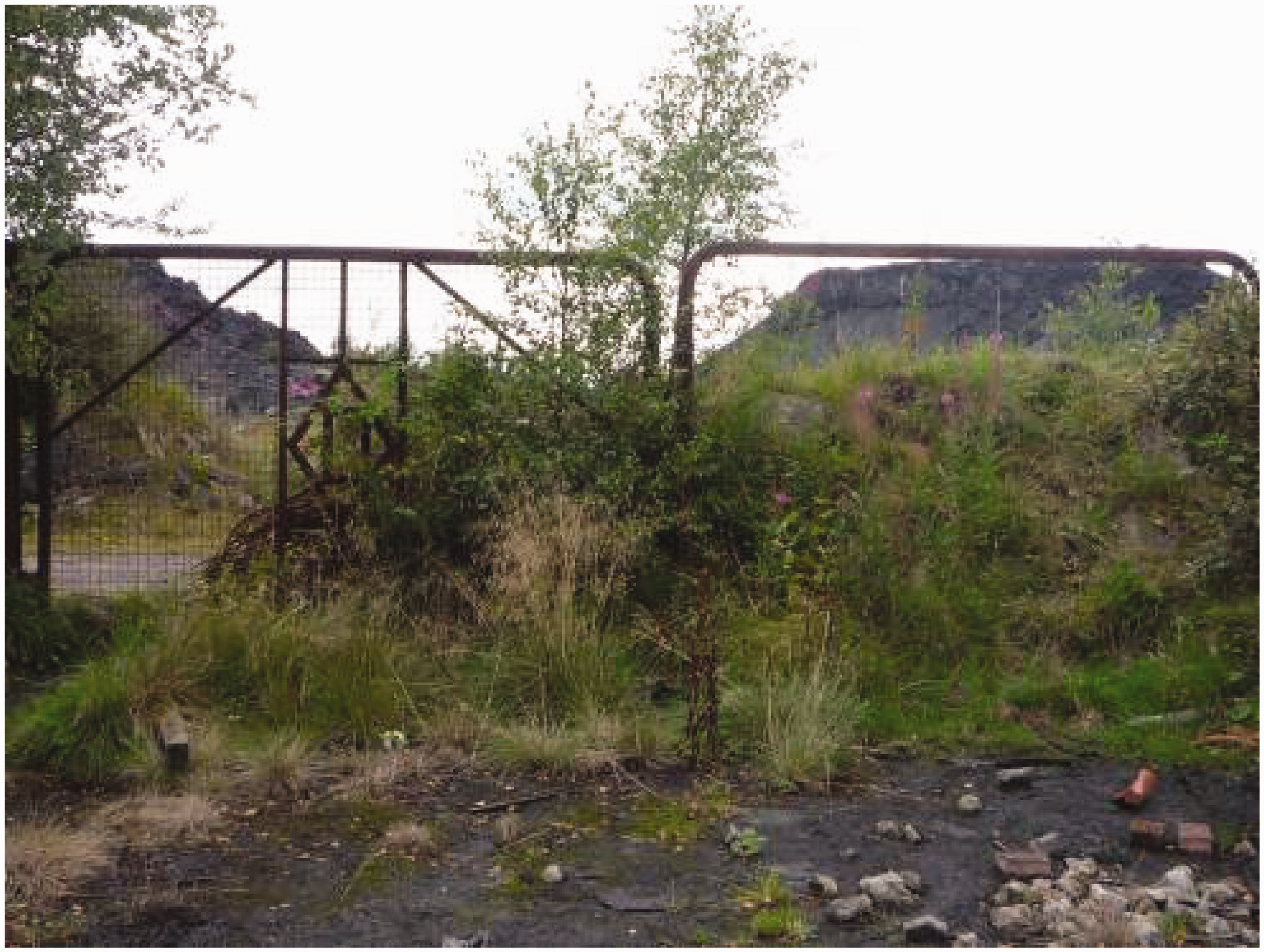
In the latter part of the 1990s and into 2000, the area attracted a wealthier class to large newly constructed private housing estates as the local council encouraged private regeneration through private house building (Falkirk Council, 2010). Over decades, most of the historic public buildings and traditional factories were demolished, causing a decline in community activities initiated, funded and facilitated by the heavy industry employers. There is one community centre functioning mainly as a recreation, sports and youth centre, where the historical society meets. Two notable – failed – campaigns to regenerate the area include the reinstatement of a train station, and regeneration of the town centre. Both projects were part of the area's Strategic Plan (Falkirk Council, 2010). This summary highlights an area of historical significance in industrial terms, as well as a place that is in a transitional state from heavy industry to post-industrial commuter town, subjected to relatively low levels of intervention by various agencies in its present and future.
Operating within this environment of a forgotten past with a damaged landscape, and a lack of physical public space, is Greenhill Historical Society. One of the authors was the Community Learning and Development Support (CLD) Worker in Bonnybridge until mid-2012, and amongst other activities set up adult education projects taking as their inspiration the context where residents live their everyday lives. The Greenhill Historical Society was set up in 2008 and predominantly consists of retired adults over the age of 60 who have lived there most of their lives. In the next section we layer respondents' representations of their place, and their work within the official context, and interpret these as civic action processes of (re)mapping based on their readings and re-readings of maps, both in the interviews and their activities outwith. We argue that the wider context they are operating in influenced respondents' ground-level relations with their spatial and temporal location through working within and against it.
Activities of Greenhill Historical Society, Bonnybridge
From November 2010 to November 2011 we observed a number of their activities. The Society's work mainly concentrates on the area's industrial past through events, exhibitions and publications on their research. They gather new knowledge from residents outwith the group through receiving and archiving donated and lent historical materials, public calls for information, archival materials in local municipal archives and museum stores, and ‘found’ materials gathered from mine shafts, old factory ruins and suchlike. The group regularly walks the landscape using current and historical maps and photography, produce their own photographs and interview fellow local people. Their collections are a combination of their own work and those of residents more generally, and placed into an open format for exhibiting. Rather than creating panels for visitors to ‘read’, they display objects, memorabilia, maps and stories for the wider public to discuss, add to and dispute (see Figure 2). This generates new subject matter and perspectives on the place with the purpose of forming a public conversation, towards gathering more information and materials that might be ‘out there’. These collaborative processes – which had not yet been done on this collective scale – form the basis for their work. They publish a free magazine several times a year, which is a combination of short historical articles by Society members, memories from local people sparked by these articles, introducing new historical topics, calling for information on unknown elements of the past and contemporary and historical photographs and maps. Because much of the history is not already ‘there’ to build on, much of their work is starting from the beginning in ways that allow the group to collect, interpret and represent represent histories that matter to them.
Example of an ‘open exhibition’ by Greenhill Historical Society (photo by Gillian Cowell).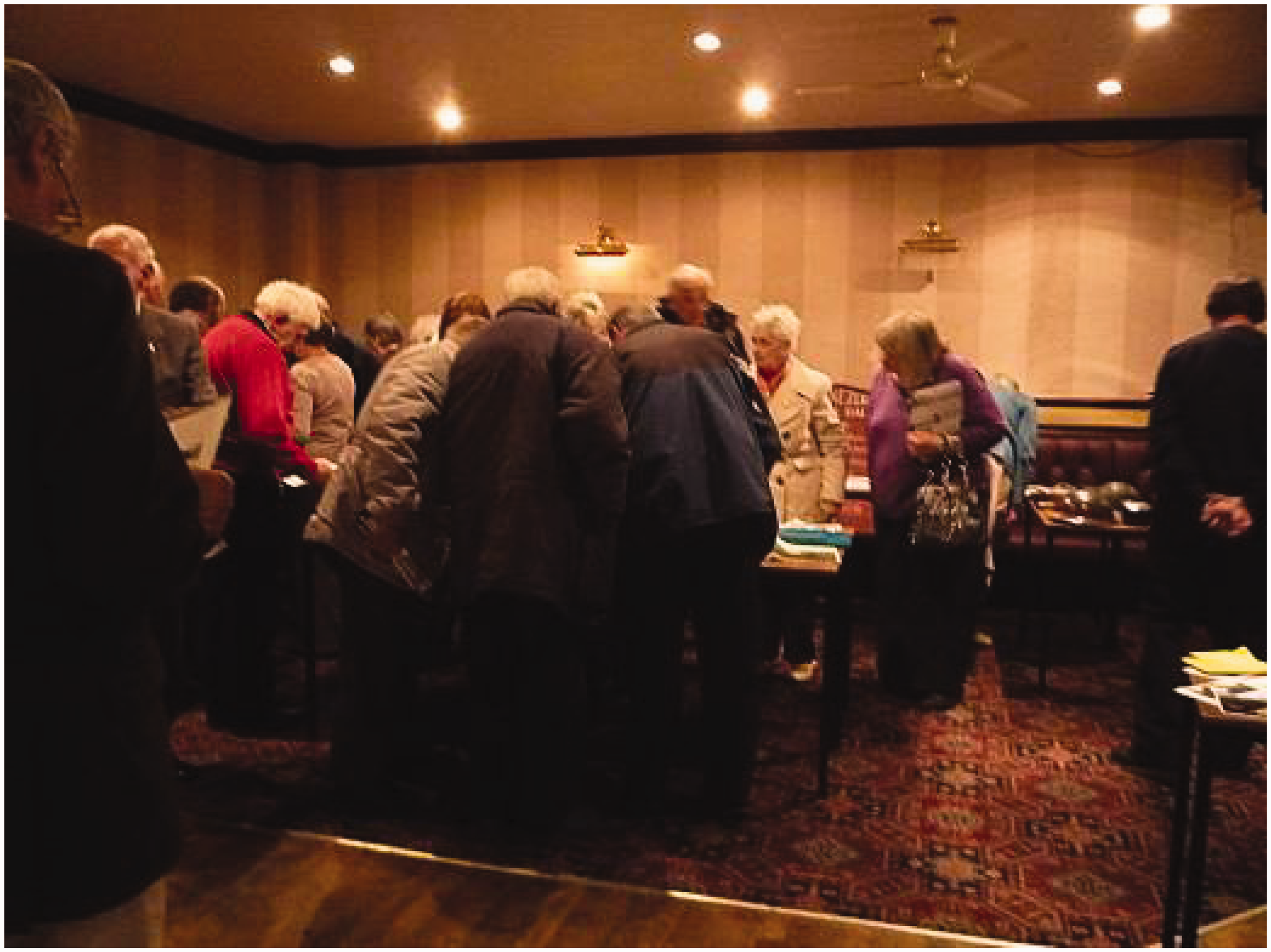
Psychogeographic mapping exercises: re-mapping as reconsideration through civic action
The topic of re-mapping – as a democratic process of reconsideration through action in public – emerged from the data we gathered from the mapping exercises and discussions from the second part of the interviews, as well as observations of respondents’ work in practice. The purpose of these mapping exercises was to understand how respondents related to particular spatial aspects of their location, and the ways they represented them through talking about and acting upon specific sites. The map presented in Figure 3 positions Bonnybridge in its wider context; labelled are the various ‘districts’ of Greenhill and High Bonnybridge, to give a wider understanding of the geography.
Bonnybridge in its ‘whole’ with labelled districts: Bonnybridge, Greenhill and High Bonnybridge. © Crown Copyright and Database Right [2014]. Ordnance Survey (Digimap Licence).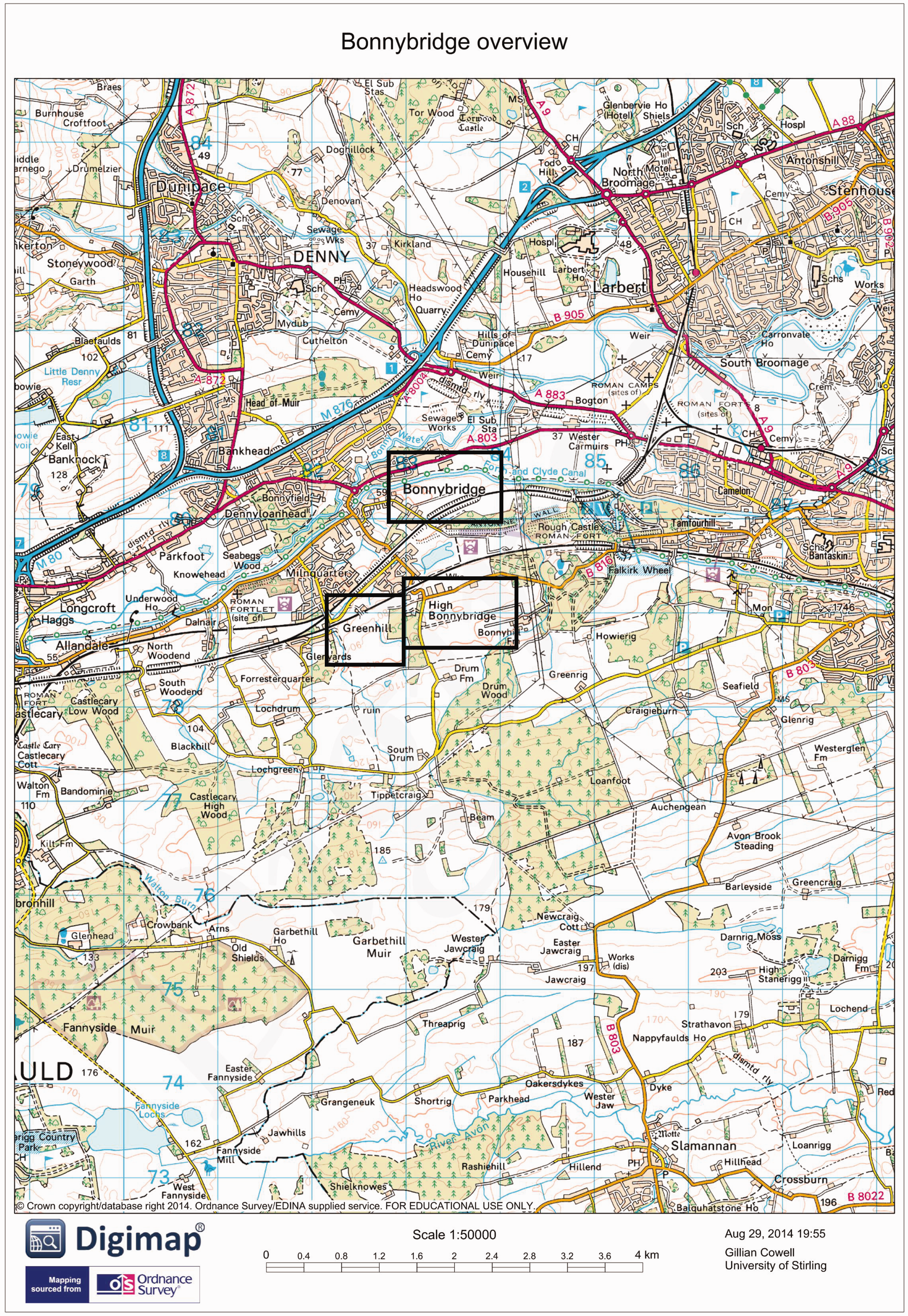
Stemming from this map, Figure 4 is a visual representation of the data gathered from participants – the patterns and boundaries we plotted from the mapping data together, as respondents mapped and discussed their understandings, uses and actions upon Bonnybridge. These mappings result from respondents’ layering of lost and abandoned historical spaces over the present landscape. As can be seen, from the research data Bonnybridge was ‘split’ into different parts as a result of respondents’ layerings of lost and abandoned histories once present, over the present landscape, specifically routes and pathways they knew and used, or had knowledge of as significant historical spaces. These multiple boundary spaces were also formed through excluding those pieces of the geography, of the map, ‘in between’ the boundaries. These in-between spaces consisted of new housing estates, places too far gone to map and areas completely unknown, as well as spaces not ventured into or used in their work. We define this map as resulting from political processes of ‘reconsideration’ in a spatial form – that through residents’ actions and engagements with loss they multiplied ‘Bonnybridge’ as a place with multiple boundaries, and with multiple visible and invisible characteristics defining it. These mappings thus emerged through their active participation in giving the place more solid, yet indefinable- and multiple, shifting and emerging – characteristics.
Outputs of psychogeographic mapping exercises with Greenhill Historical Society (GHS) respondents, Bonnybridge. © Crown Copyright and Database Right [2014]. Ordnance Survey (Digimap Licence).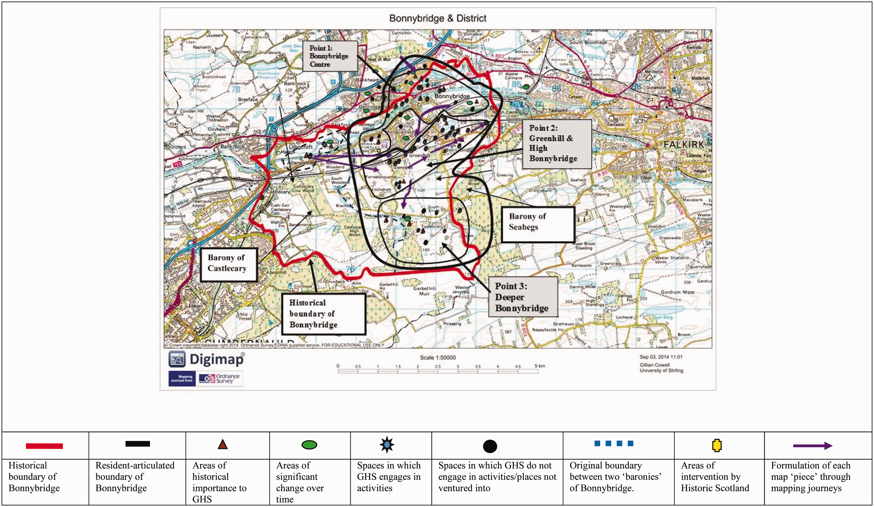
As examples, three of these points formed distinct bounded areas and included the following. (1) Bonnybridge without a centre: the lost buildings, streets and iron foundries forming a boundary around the old to the exclusion of new housing areas. (2) Greenhill and High Bonnybridge – the clay seam lying underneath and thus where multiple brickworks had once been present. Forming a distinct ‘place’ as separate from the first interaction point, these formed a particular pattern through tracing and re-siting the many brickworks that are now gone. Figures 5(a) and (b) show the work of one member, who, based on his own research and data gathered from an open exhibition, re-inserted the brickworks into a map. (3) Southern Bonnybridge – the Targets, Clayknowes and other lost places. This was the wild part of Bonnybridge that is difficult to map because of its remoteness, high levels of decay and declining official knowledge of its spaces. It can be seen that the spaces unknown and not used in their work form the parts in between – and outside – the boundaries. Thus, through the different mappings, artefacts and actions of residents there is no real sense of what Bonnybridge ‘is’ in spatial terms, and is rather multiple sites and places allowing for multiple actions. These are processes of drawing boundaries, and remapping histories – civic processes of spatial reconsiderations that redefined the borders of their place, revealing hidden and lost places through their actions in the historical society.
(a) Open exhibition seeking debate and knowledge on the lost brickworks (photo by Gillian Cowell). (b) Re-mapping lost brickworks (map courtesy of Willie Thomson). (1) John G Stein, Castlecary Works, 1899–1980. (2) Glenyards Fireclay Co., 1880–1964. (3) Greenhill Fireclay Works, Clayknowes, 1860–1922. (4) George Turnbull, Dykehead, 1906–1962. (5) John G Stein, Milnquarter Works, 1887–1971. (6) Bonnybridge Silica and Fireclay, 1874–1972. (7) Woodlea, 1890–1892. (8) James Dougall and Sons: (a) West Works; (b) East Works, 1875–2002. (9) Cochran's Brickworks, 1906–1930. (10) Broomhill Brickworks, 1915–1970. (11) Campbell & Co. Roughcastle, 1892–1965. (12) Bonnymuir Brickworks, 1836–1960.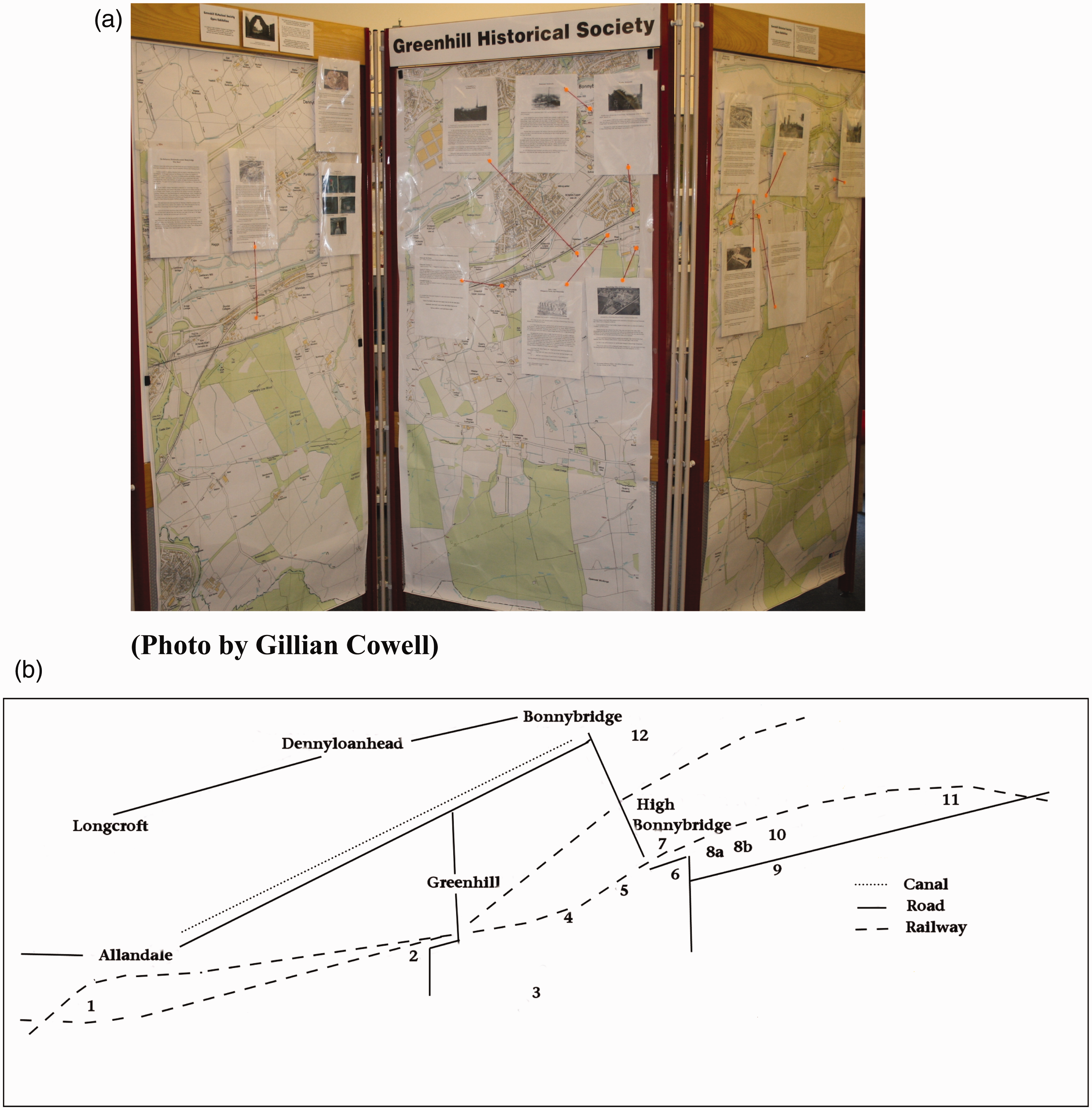
It is worth highlighting that its many boundaries emanate from its abandonment and damaged present, causing it also to be a place of no boundaries through its numerous lost and hidden historical spaces and points in time. We argue that it was precisely in the ways Bonnybridge was forgotten and under-represented in historical literature and by public agencies that allowed respondents to multiply understandings of it, leading to their actions upon the map to multiple it. However, although multiplication allowed for many different actions to emerge, paradoxically these actions were allowed precisely because of the declining and forgotten nature of this place. Thus, multiplying Bonnybridge through remapping involves respondents’ actions in splitting open the smooth cartography of present-day Bonnybridge to represent many different places, rather than one place. Each place had access points rendering hidden or invisible spaces visible again. These ‘interaction points’ that multiplied Bonnybridge put back onto the map areas that had disappeared that were of historical importance to residents.
Case 2
The reconfiguration of Cumbernauld Village: from ‘being mapped’ to ‘remapping’
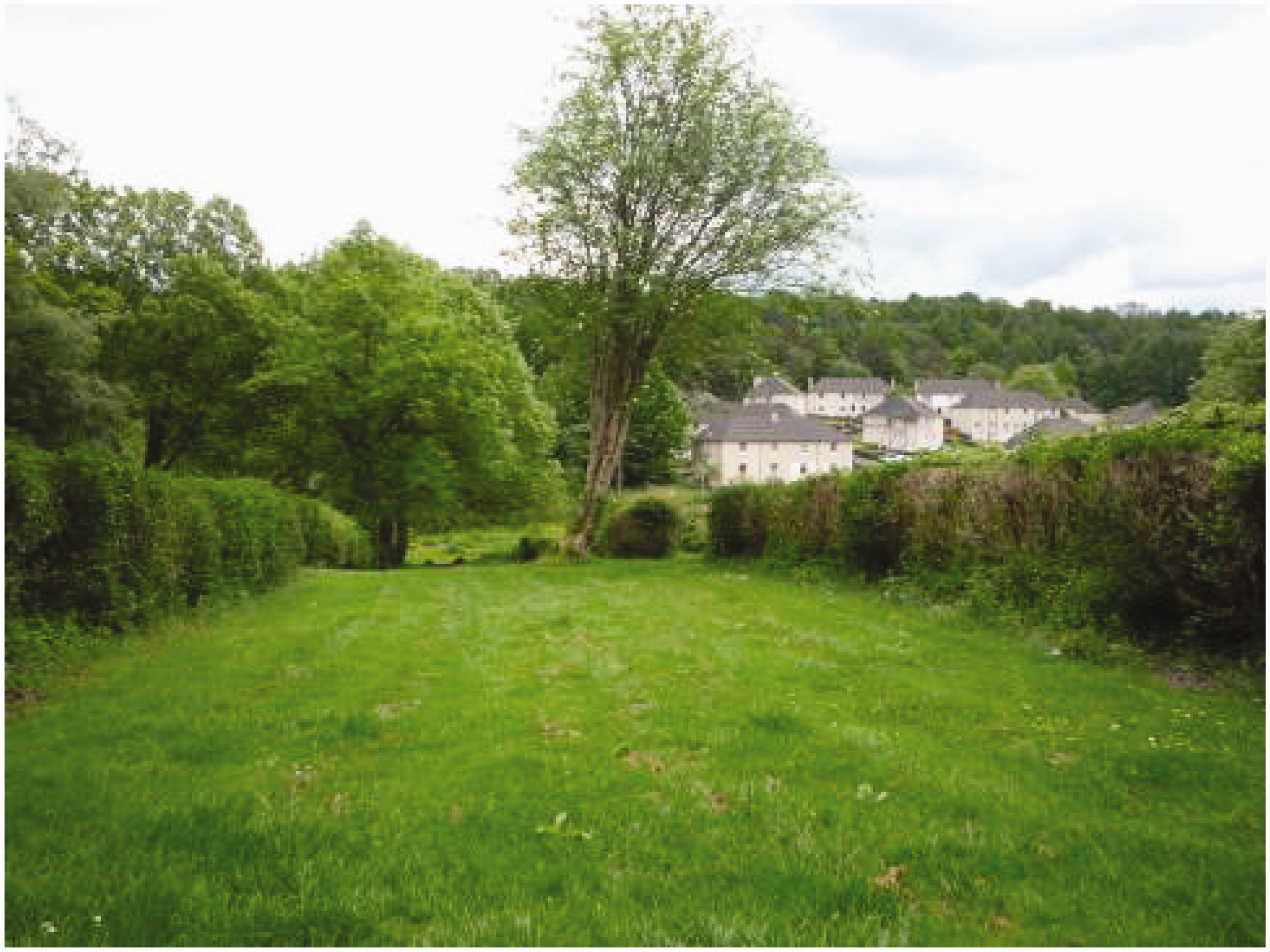
Official historical writings of Cumbernauld Village position it as an ancient pre-medieval village, dating from the time of the Roman settlements on this site, their most northerly frontier, and presently part of the local municipal council of North Lanarkshire (Hutton, 2007; Millar, 1980). The village is located in the centre of Scotland, very near Bonnybridge, and was originally a small rural weaving community with strong brick making and farming industries (Village Community Council, 2012). The characteristics and layout of the village have remained stable over the centuries. This is mainly due to interventionist movements by local and national government town planners, ensuring its historic features are preserved as well as conserved, whilst allowing for new homes to be built within its boundaries (Village Community Council, 2012). Hutton (2007) argues that the government-planned New Town of Cumbernauld, established in 1956, which took its name from Cumbernauld Village, has attracted so much attention that the village pre-dating it is still relatively unknown. Figures 6(a) and (b) show the village located ‘inside’ the New Town that has grown up around it. As Provost Murray (in Millar, 1968: v) states: ‘The geographic considerations that played an important part in the selection of Cumbernauld as the site of a new town, have, since Roman times, caused Cumbernauld to be at the ‘cross-roads’ in a historical sense’.
(a) Cumbernauld Village located ‘inside’ Cumbernauld New Town, which grew up around the ancient village. (b) Cumbernauld Village in closer detail. © Crown Copyright and Database Right [2014]. Ordnance Survey (Digimap Licence).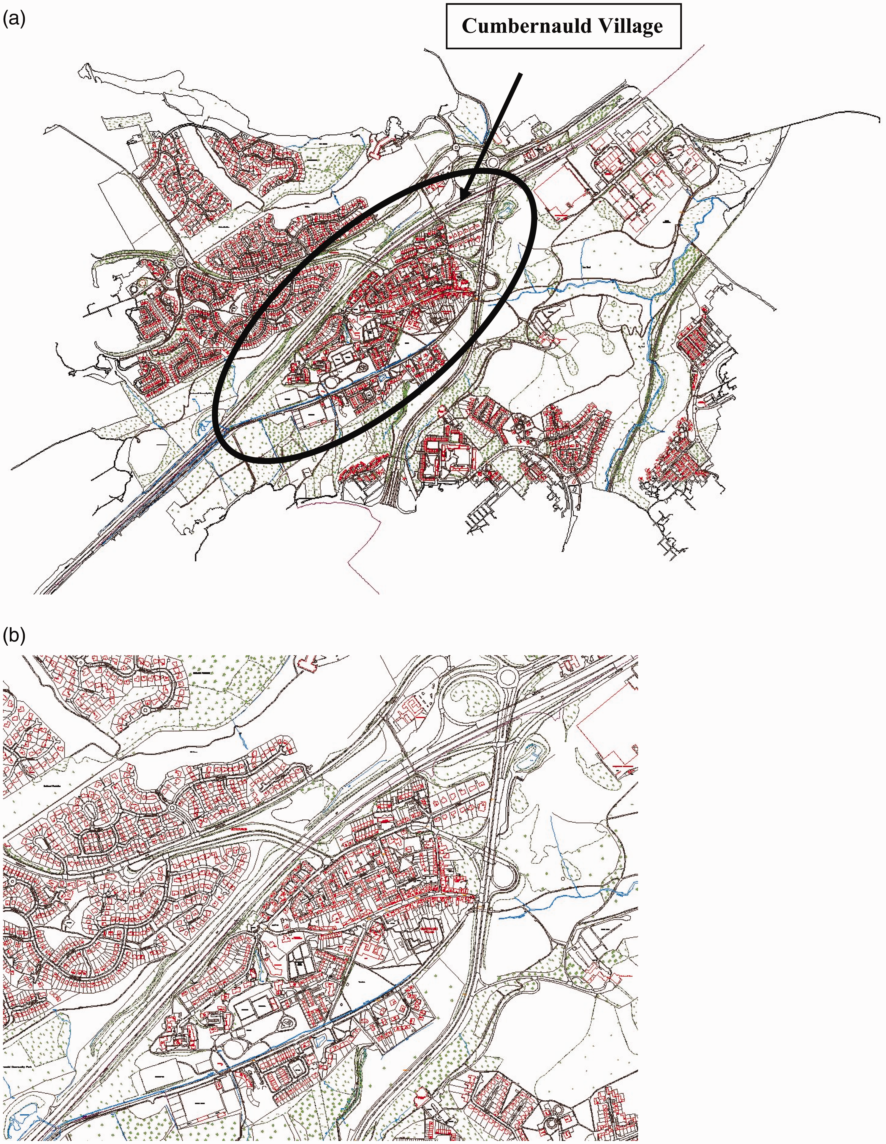
As a Conservation Area, a definable section of the village has been designated historically significant and protected under conservation law from being altered. This is part of a larger scheme to retain the special characteristics of the village and preserve its uniquely historic state, with a Conservation Area Regeneration Scheme (CARS) operating there. A Historic Scotland scheme, the purpose of CARS is to set up regeneration and conservation activities between, in this case, the local authority of North Lanarkshire Council and local businesses and community groups, including CVAC. Thus, the village retains its unique medieval configuration precisely because Cumbernauld Development Corporation, the quango appointed by the Secretary of State for Scotland to manage the building of the New Town (and pre-North Lanarkshire Council), appointed an architect to develop and preserve the character of the Village (Hutton, 2007). This architect, Philip S Cocker, managed a programme of building restoration involving rebuilding houses behind their existing frontages, highly praised by the Royal Fine Arts Commission (Hutton, 2007). Thus, parts of the housing in the Main Street and Baronhill areas, and the langriggs behind – all within the Conservation Area boundary – were restored back to their 19th-century configuration (Village Community Council, 2012). These were previously remembered as derelict in the 1950s and 1960s by residents. The Main Street has changed little over the last century in both layout and building style.
Psychogeographic mapping exercises: from ‘being mapped’ to ‘re-mapping’ – spatial reconfiguration as civic action
Figure 7 represents the data from interviews and mapping exercises with respondents together in one map. Contrary to Bonnybridge, the area emerged as ‘one place’, which we argue is partly due to local councils’ conservation and restoration policies over time and partly to the ‘bounded’ nature of its physical geography. Respondents themselves also broadly articulated the same history in their descriptions of what they considered to be their place in the past, adding to this stable ‘whole’.
Outputs of psychogeographic mapping exercises with Cumbernauld Village Action for the Community (CVAC) respondents, Cumbernauld Village. CARS: Conservation Area Regeneration Scheme; NLC: North Lanarkshire Council. © Crown Copyright and Database Right [2014]. Ordnance Survey (Digimap Licence).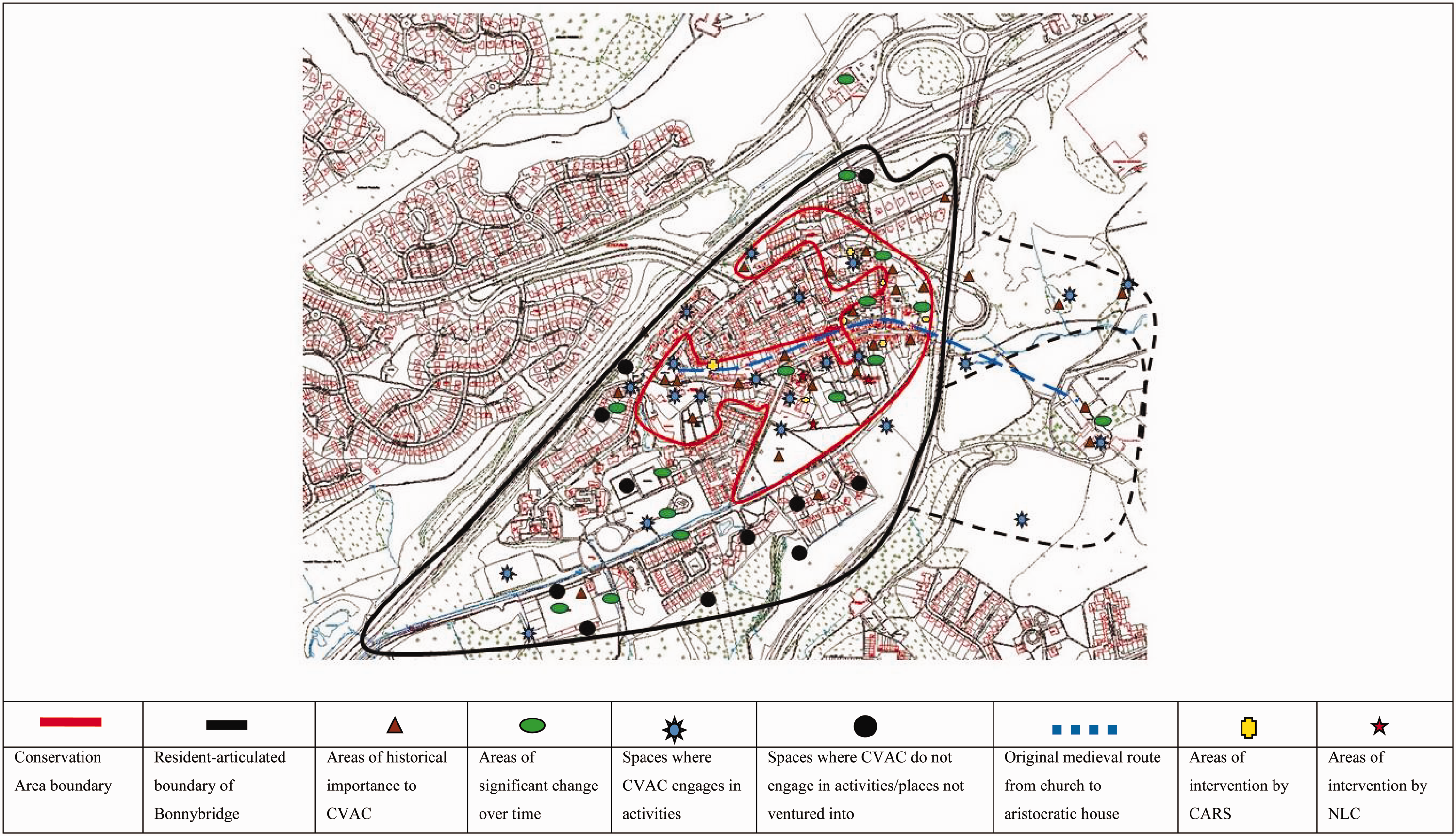
Thus, Cumbernauld Village emerges as an area of restored, singular and visible geography and history through its maintained historic characteristics. However, because respondents did not identify with nor relate to some of the conservation and restoration practices of the local council, residents focused their interventions in certain outdoor spaces. This provided them with opportunities to represent their own landscape. These historical spaces included actions upon the langriggs area (long, narrow pieces of land, previously the market gardens of the village), developing new allotments, orchards and food-producing spaces historically present in the area for over a century. These interventions created another ‘layer’ over the official Conservation Area landscape in the form of an alternative resident-articulated village scape, emerging over the officially conserved landscape. This layer was still based on what was there in the past, but the activities were resident-led, making visible aspects of what they considered to be important to the past of the place. We define these activities as reconfiguration, demonstrating both respondents’ restrictions, and freedoms, to act in and around these spaces. We will deal with one site-specific intervention by CVAC in the village: the langriggs. The langriggs are within the Conservation Area boundary.
Through our analysis of documents on the langriggs, including reports by North Lanarkshire Council, the langriggs have had a continuing visibility over time within policies and campaigns both by North Lanarkshire Council and residents. The Council ‘owns’ and maintains them at an official level. Historically the market gardens of the village, interviewees discussed that the langriggs exist today in their historical configuration because they were the target of recurrent campaigns in the 1970s and mid-1990s to save them from being sold to private house builders (see Figure 8 for a map showing their distinctive shape). As one respondent explained: There was quite a big campaign…to save the langriggs. There was a plan to take away a wee bit down at the corner for two or three houses, and the community council fought it and took it to the Kirk Session and we certainly complained about it and local councillors all complained about it. So we've been guaranteed it will not be built upon. So that was a wee victory that we had too because it's the only example of the langriggs that's left in Scotland I think. Not so many of the full size that are left there.
Close-up of langriggs on map showing distinctive long shapes (2014). © Crown Copyright and Database Right [2014]. Ordnance Survey (Digimap Licence). …it's the oldest and the most complete langriggs in the whole of the UK…In Linlithgow they've got two or one and a bit or something like that, whereas ours are two dozen or more. So what we want to do is bring them back into what they were used for which is market gardens; now they're called allotments. Example of one ‘langrigg’ at ground level (photo by Gillian Cowell).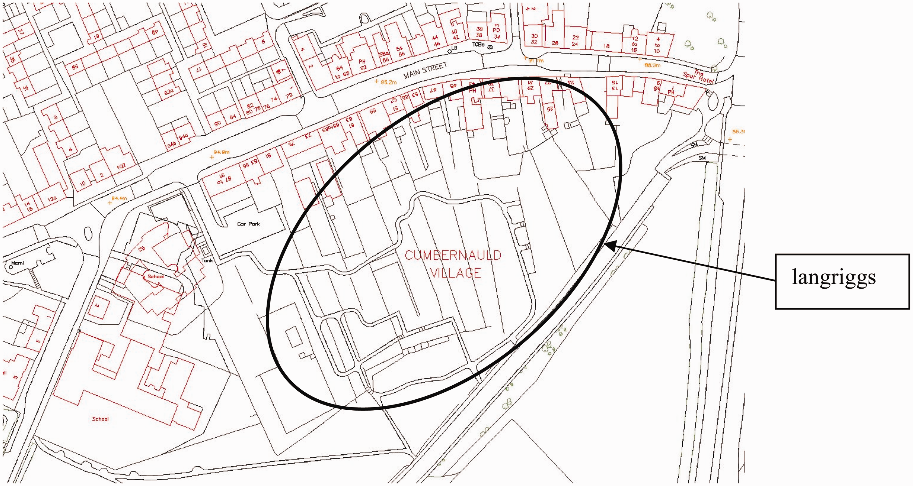
Without the interplay between official and ground-level actions it is possible these configurations would not be included in future maps, because they would have been destroyed in the landscape itself. As has been demonstrated thus far, the restrictions created through conservation rhetoric stemming from the demand by local people to preserve the langriggs – and the resulting continuity of their historic configuration into the present – has resulted in forms of mapping ‘on their behalf’. The group is restricted to keeping ‘within the lines’ of the conserved riggs, that is, their boundaries cannot be altered. However, the paradox is that through preservation they have also been able to create interactive projects on these langriggs, which would not have occurred had there been no public preservation campaigns. It is in this way we argue that respondents have been simultaneously ‘mapped’, tied to working within the lines through their own campaigning, but also allowed to engage in processes of re-mapping – a civic process of developing projects ‘within the lines’ that make demands on others to participate in these historic areas in the present.
Discussion and conclusions: maps as processes and practices
In this article we have explored the role maps can play in processes of civic action, that is, action that is orientated towards a shared, common or public location. We were particularly interested in the active mapping processes central to civic action. Against the background of a distinction between a socialisation conception of civic action – one that sees civic action as the reproduction of existing socio-political identities – and a subjectification conception of civic action – one that focuses on the ways in which individuals can be active and creative agents of political action – we have suggested that active engagements with maps (mapmaking) allow residents to critically open up official representations (mappings) of the locations in which they lead their lives. Mapmaking thus allows for different ways of acting and being in relation to official representations of particular locations and can thus lead to a critical reconsideration or reconfiguration of such locations. Maps used in the cases we explored allowed for possibilities and alternatives to current understandings of place rather than closing them down. Rather than working against the map, it actually allowed space for action towards mapping their place from the perspective of absence.
It is in precisely this sense that mapmaking can be understood as a process of subjectification, that is, of the generation of new social and political identities that not only contest existing representations and prescriptions of how a location should be understood and engaged with, but that at the very same time generate new ways of being and doing in relation to new reconsiderations and reconfigurations of the very location. Against the idea that maps and mapping tend to disempower individuals by keeping them ‘in their place’, our research suggests a much more empowering and emancipatory role for maps and mapping – one that particularly opens up in the space between official representations and contested alternatives. Mapmaking, then, is not only a research tool for opening up official representations of location – temporally, spatially and relationally – but is also a political tool for the generation of new considerations and configurations of community that weaves its way through processes of orientation and disorientation towards reorientation practices that demand attention to alternative forms of places. Maps are, therefore, at the very same time a tool for research and a tool for civic action and democratisation.
Footnotes
Declaration of conflicting interests
The author(s) declared no potential conflicts of interest with respect to the research, authorship, and/or publication of this article.
Funding
The author(s) received no financial support for the research, authorship, and/or publication of this article.
![]() ) is currently Professor of Education at Brunel University London. His work focuses on the theory and philosophy of education and the theory and philosophy of educational and social research. His most recent book, The Beautiful Risk of Education (Paradigm Publishers, 2014), won the 2014 outstanding book award of the American Educational Research Association (Division B).
) is currently Professor of Education at Brunel University London. His work focuses on the theory and philosophy of education and the theory and philosophy of educational and social research. His most recent book, The Beautiful Risk of Education (Paradigm Publishers, 2014), won the 2014 outstanding book award of the American Educational Research Association (Division B).