
Abstract
At the intersections of rapid socio-ecological transformation, Indigenous people in Northern Australia are articulating their aspirations for land management. However, while people reconcile goals, knowledges and practices to care for Country, the available toolkit that might facilitate planning and activities has often constrained ideas because technologies and systems have tended to be both inaccessible and incompatible with non-Western representations of place. In this paper, we report on a cultural landscape mapping project with Marralam Community of the Northern Territory, Australia, undertaken to analyze, advocate and communicate community ideas, knowledge and visions for managing Country. Prioritizing culturally respectful ways of working, we articulate mobile mapping methods that speak to the experiential, emergent and performative, and political aspects of how our research collaboration is mapping together with Country. Harnessing the innovations of qualitative GIS, mapping with Country ‘on-the-fly’ facilitates what may otherwise be conceived of as competing demands and interests, highlighting Indigenous expertise in navigating the complex terrain of natural resource management and knowledge sharing. Mapping with Country foreshadows lively possibilities for mapping as more-than-human collaborative research practice.
Introduction
Its November, early wet season. Despite our late afternoon cooling swim, the kids are restless on the way back to camp. Sweat sticks our backs and legs to the vinyl seats of the 4WD and we wind down the windows to get some air as we snake the vehicle carefully along the bumpy gravel road. And then, as we clear the low hills and speed up along the sandy flats, there is a shout from Bernadette in the back seat “Marai!”. I quickly stop the car and all of us spill out, back tracking into the dust in a race to find the plant. Clustering around Bernadette, we marvel at her keen eyes. Scanning from above in the car she says, “you look down to spot the slender pale green stem emerging from the dry grass”. “Crouching low on foot, you look through the grass for the hanging bell shape of purple flowers”. Bernadette starts digging, revealing a juicy potato shaped tuber. After some excited chatter, we all pile back into the car, the kids settled, immersed into the game. Marai are found as families. Plants grow in close proximity. The prospect of finding more builds an air of anticipation and attention.
Jennifer Atchison, field journal, 2017
This paper addresses the ontological distinctions between how and what we map, by considering the practice of mapping with Country. Mapping ‘on-the-fly’ is our short-hand annotation for a cultural landscape mapping process that we argue works together with Country. It was inspired by a game played for many years – looking for Marai – described in the opening vignette, which we played during fieldwork with members of the Marralam Community, in the Northern Territory, Australia. Our collaboration was tasked by the community to develop a weed mapping project to support goals to address invasive plants, aligned to their recent ‘Healthy Country Plan’. 1 With the focus on weeds, we didn’t plan to map marai – a small, delicate, native lily. However, this game elicited an understanding of Country that was emergent, evoked and shared in response to knowledge, stories and memories embedded in Country. What was shared through this game, and which we share here, is how to work with Country, mapping together through unexpected moments and windows of opportunity.
In Australia, diverse Indigenous peoples use the term Country to refer to all that is, has and will be.
2
Such a description challenges the tendency within natural resource governance to assume it as standing in for what might otherwise be called the ‘environment’ or the ‘landscape’. In their Healthy Country Plan, Gajerrong people describe Country in the following way: Country is like a child. You have to nurse it. . . . Country is a real live thing and it won’t let us ignore it. When we are away from our Country, we cry for it because we are lovesick for it and we feel it.
3
When Gajerrong people cry for Country, they respond to the cries of Country, and they are accountable to their ancestors and other relations. Country’s cries are calls for consideration, demands for acknowledgement and assessments of action; a plant out of place, a co-incidental encounter, a feeling that creeps over your skin as a memory is recalled. Country is a political and dynamic force, it compels action, it governs relations, but it is not undifferentiated; it has moods, a will, a temper and expressions which can be both predicted and surprising. Country signals, it communicates, and has lessons for those who know its stories, and can read and understand it. 4 Crucially, Country includes people – not as components or parts of a landscape, but as together whole. 5 Country without people is diminished, thus the Gajerrong Healthy Country Plan is inclusive of people and their wellbeing. These ontologies of Country seep into the composition and fabric of Gajerrong life. And they disrupt a simplistic reading of the game we played, in relation to our mapping task. A reading of the game as a distraction to our work re-represents damaging western ontologies of nature and culture, as separate and distinct, and where nature is the background to human activity. Instead, Gajerrong ontologies provoke us to consider how Country, as diverse, distributed, multi-dimensional and affective, all at once situated and contextual, cries out for our attention and calls us into action. In other words, how it was already within, and might need to be acknowledged in our mapping work.
The mapping process we describe responds to Gajerrong understandings that Country inspires and shapes these affective agencies of being, knowing and doing. What we are asserting is that when a relational understanding of life is privileged there can be no mapping without Country. By implication, although they may not feature on a map, there can be no mapping without people. 6 Thus, our mapping is also inflected through the social relations that bring it into being, which privilege connection, reciprocity and trust, and which enable us to explore the implications of Indigenous relational ontologies. Jennifer has been working with Marralam Community for 30 years, discussing culture and plants and how they have changed over time. 7 Our relationship includes Jennifer living in community, visits for holiday and family connection, and visits by Bernadette and her family to Jennifer’s home in southern Australia. Jennifer is in regular communication, celebrates milestones and attends sorry business. 8 Bernadette describes this relationship as familial, ‘we’re family, this is not just about working, you know, [you’ve] been pretty much in our lives. We have worked together since me and my siblings were children, and our children have been together’. This relationship affords an understanding and respect of Gajerrong cultural protocols, as well an appreciation for how the community is working to affect change. Never-the-less, Jennifer, Tom and Eli as non-Indigenous scholars, and the latter as more recent collaborators, recognize, their positioning in the academy presents an uneven educational, financial and institutionalized dynamic with power and privilege. Ongoing efforts to be accountable to this positioning include monitoring the project with community to ensure feasibility and benefits, seeking and incorporating advice from peak Indigenous organizations, obtaining formal oversight, 9 and providing financial and practical support, including outside of research activities.
Our aim in elaborating mapping with Country as more-than-human process, is to contribute to what others have offered as the ‘cultivation of a vitalist geographical imagination’ through mapping. 10 Bringing post representational cartographies into conversation with Indigenous and more-than-human mapping, is argued to offer possibilities for ‘re-animating’ or ‘revitalizing’ cultural landscape mapping in a range of social and ecological contexts. 11 In what follows, we explore these possibilities and their limitations. We first outline the tensions involved in mapping with Country in conversation with efforts to illustrate the damaging ontologies and colonial effects of mapping, and emergent discussions to animate the map. We then locate Gajerrong Country and the methodological considerations that emerged in our research. Our results articulate three dimensions of more-than-human mapping, attending to our practice as: experiential, emergent and performative, and political. Together these illustrate how we mapped with Country, but also how Country mapped its way into the process of our research.
Navigating the tensions of mapping, and maps
Here we situate our mapping within critical scholarship addressing the colonial and damaging histories of mapping and maps for Indigenous people, as well as their more hopeful possibilities. Our focus is on mapping as a practice, although descriptions of it as ‘visually explaining and defending issues that arise from cultural use of territory, including land claims, natural resources and sovereignty’, 12 do not provide a satisfactory analytic in relation to the ontological worldviews outlined above. As such, we emphasize mapping as action, 13 with intent to effect. There are (at least) five tensions that inform our thinking about the practice of mapping with Country.
First, the impetus for the current project reflects the contemporary development and environmental governance setting in Australia which, sanctioned through the colonial context, privileges western forms of environmental knowledge, its production and circulation in natural resource management planning. Invasive plant management specifically, privileges scientific knowledge about biodiversity – weeds – to be prioritized in management. 14 Communicating contemporary community ideas about plants thus intersects with rationalist science prioritized in highly articulated structures that govern the environment, and the resources that facilitate management.
In this context, the power of maps is well known to Marralam Community, since it is how they learn about decisions made about their Country from elsewhere, including in the form of recent development proposals. 15 Marralam Community thus recognize the affective nature of maps to represent, and communicate information about their Country to distant others, reflecting their knowledge that maps can ‘codify, legitimize, promote and shape’ the world. 16 In land and natural resource management contexts, cultural landscape mapping is described as a tool through which communities can project their own social, economic and environmental attachments to place although the extent to which such projects ‘reverse, re-orientate, or rework’, colonial power relations are contested. 17 While some have drawn a distinction between cultural landscape and territory mapping, with the latter retaining a legal focus on territorial sovereignty, 18 others have pushed to retain a broad definition, 19 noting cultural landscape mapping can facilitate critique of dominant regimes. 20 Marralam Community are anticipating the possibilities of mapping to influence those with decision-making power, reflecting the difficult position they are in, and their desire to participate within contemporary governance, and protect culture.
Second, as critical cartographers and others note, maps and mapping have an ongoing colonial dynamic in settler societies including Australia, which has been damaging for Indigenous interests. As the artefacts of mapping, maps have been a key element of how Indigenous people were dispossessed of their sovereign lands and continue to be erased. 21 Further, the application of mapping for Indigenous interests has included knowledge being ‘distorted, suppressed and assimilated’. 22 Gajerrong people are acutely aware of these interconnected facts; they read topographic maps which do not recognize their sovereignty, with familiarity, having used them to orient miners and bureaucrats from helicopters, and confirm the location of sacred areas in what is known as ‘clearance’ work, where Indigenous people are asked to participate in designating areas as clear of sacred sites, and therefore legitimate the pursuit of external development interests. Mapping is thus part of how Gajerrong Country has been assumed and damaged.
Cultural landscape mapping may be a vehicle for Indigenous ambitions to be realized, 23 but these are new prospects for Marralam Community. In Australia, cultural landscape mapping has a heritage within planning processes that have sought to include Indigenous people. ‘Working on Country’, 24 ‘Planning on Country’, 25 and cultural planning and assessment, 26 all document methods for mapping with Indigenous communities, although we note their different ontological positions in relation to Country. In ‘Mapping Attachment’, Byrne and Nugent illustrate the depth of ‘stories, histories, memories and emotion’ threaded through landscapes. 27 Counter-mapping, first proposed by Nancy Peluso, 28 engages directly with the assumptions and hegemony of conventional ways of knowing and proposes non-conventional use of technology to step outside cartographic norms. 29 Interventions by Indigenous scholars articulate concerns for a continued focus on affirming sovereignty. 30
Third, a desire for meaningful involvement of Indigenous people in mapping means taking seriously efforts to decolonize this process, 31 and assumptions about it as new. Mapping has been a part of how Indigenous people express their knowledge and attachments to land, sea and sky for millennia. Decolonizing mapping, according to Rose-Redwood et al., implicates a politics of knowledge, specifically how Indigenous knowledges are valued and prioritized. 32 The breadth and scope of Indigenous interests in mapping is extensive; acknowledgement and recognition of the sophisticated and diverse ways by which Indigenous people may express their interests is thus vital. For example, work by the Gay’wu group of women, describes how Yolgnu women ‘cry milkari’, and in doing so, ‘sing the map’. 33 In Brazil, Xavante, Suya and Kayabi Nations express their understandings of the cosmos through mapping and mathematics. 34 Maaori assert that they have been ‘doing cartography and GIS since the beginning of time’. 35 These works hint at the distinct epistemologies through which Indigenous people may articulate and incorporate mapping. 36
Relatedly, decolonizing mapping involves a politics of inclusion, how people participate in the process and what their participation legitimizes. 37 Contemporary geospatial technologies do not automatically improve problematic dynamics, indeed as Robert Rundstrom cautioned nearly three decades ago, mapping and ‘GIS technology, when applied cross-culturally, is essentially a tool for epistemological assimilation, and as such, is the newest link in a long chain of attempts by Western societies to subsume or destroy indigenous cultures’. 38 Some are reporting how digital platforms are being used to facilitate skills transfer and knowledge sharing, 39 and indicate more accessible technologies have helped facilitate a new phase of Indigenous storytelling of place. 40 In the present project, community members are leading the project design, as well as articulating how it will progress. The funding context of this project 41 secures resources for the appropriate discussions and time required to articulate these protocols.
Fourth, and related to the above, decolonizing mapping also requires rethinking the frameworks and the methods used to represent the ontological structures, and ‘syntactic rules’ for categorizing and representing phenomena. 42 Critique from Indigenous scholars pinpoints that the mostly western frameworks (and geospatial technologies) that facilitate cultural mapping continue to marginalize Indigenous people, including because they fail to account for Indigenous ways of knowing and understanding place. 43
Considerations of the practices and performances of mapping are just beginning to unpick western Cartesian conventions for knowing and representing landscapes. 44 In relation to fostering Indigenous cartographies, Sletto illustrates mapping as a social process figured through walking to inspire new forms of knowledge production, 45 while McConachie et al. address Indigenous ways of knowing within cultural mapping to demonstrate and share values. 46 Others have brought attention to the experiences of mapping to reveal and emphasize its non-representational, embodied, and relational qualities. 47 Clancy Wilmott, drawing on Michel Foucault and Doreen Massey, argues mapping bridges the distinction between the subject (mapper) and the object (map) in a practice of drawing relations together. 48 Illustrating the mapping that people do through spatially enabled technologies, Wilmot narrates mapping as attending to the sensations of going around, under, through etc. and the representation of this movement through lines, and polygons. Accordingly, maps become, irreconcilably, representations with presences and absences, and mapping an embedded, performative, political practice in a continuous flow of reading and unreading the world. Our collaboration was challenged to consider how the relational and affective ontologies of Country might be recognized and organized through mapping and facilitate participation.
Fifth, as scholars are attending to the lively nature of mapping, they are also problematizing it as static and maps as finished objects. 49 We emphasize this is presenting our mapping as a work in process. As Wilmott articulates, ‘mobile mapping’ describes a complex and affective process of inscription. Here, the more-than-human might shift from mapped object to agentic subject, as mappers learn to be affected and respond to non-Western perspectives of how place is understood and experienced. We take inspiration from Wilmott and others who are: attending to presences and absences, and noticing and responding to lively companions; 50 tracking to incorporate the voices of the marginalized in conflicts; 51 and exploring mobilities and forced removals as part of colonization. 52 These works draw specific attention to movement, acknowledging the agency and vitality of the world as more-than-human, as theorized by Tsing, Whatmore and others. 53 But they also attend to power through the relational qualities and politics of becoming in the world through mapping, and resultant changes in perspective that ensue, 54 thus providing possibilities for enacting a ‘vitalist materialism’. 55
We recognize, like others, that maps may not dispense altogether with the colonial and damaging pre-occupations of western governance and worldmaking. Instead our primary concern is how mapping may offer insights into other ways of seeing, being with and perceiving in more-than-human worlds, 56 illuminating how humans and nonhumans ‘become-with’ Country together. 57 In this regard, considering the multiple and distributed agencies of Gajerrong Country, we sought to elaborate this process, alongside modern mapping technology, and begin to reinscribe our mapping project.
Locating Gajerrong Country and working with GIS
Gajerrong Country is located in the Keep River region of the Northern Territory, Australia, and is characterized by a monsoonal climate, open savanna woodlands, rocky sandstone escarpments, seasonal freshwater wetlands and expansive tidal estuaries, Figure 1. Since European colonization began, the region has undergone significant change including the modification of Indigenous management regimes and the introduction of cattle for beef production. 58 The region remains relatively remote, and cultural connections enduring and strong, but development pressure includes pastoral intensification, expansion of agricultural production, and an aquaculture proposal. Marralam Community have freehold rights over a small outstation living area, and actively maintain their non-exclusive native title rights to access, hunt and gather over an expansive area, approximately 10,000 km2.

Location of Gajerrong Country, northern Australia. Gajerrong people refer to Hill Country, Plain Country, Wetlands and Saltwater Country. Photos by J. Atchison.
Our mapping methodology was informed by two considerations. First, it needed to align to the Gajerrong Healthy Country Plan, which identifies weeds, amongst other elements, as a priority. We commenced by developing a data management plan, articulating the principles and practices of Indigenous data sovereignty and protection of intellectual property. These documents identify the data that is for community use only, and information that can be shared more widely. We then conducted a relationship mapping exercise, where participants determined the spatial information to be recorded. Plants, animals and places were identified within relational categories: values, practices and concerns, and layers for each created within iGIS. 59 These categories reflect a perspective that entities come to be known through their relations. Each layer captures point, line, polygon and photo data, with the ability to add in comments, observations and other metadata, added to spatial data attribute tables.
Second, our work needed to accommodate Gajerrong Country. In the field, the workflow was designed and adapted to support the mobility of the team, with a four-wheel drive vehicle to cover large transects. GPS positioning facilitated tracking of the vehicle, participants and researchers in the iGIS satellite imagery, and the researchers used a digital audio device to record discussions. When driving, there was constant conversation about social, cultural and environmental changes occurring. As much as possible, we sought to work at a pace which attended to these conversations. Spatial features were added to iGIS based on these discussions and recorded conversations were timestamped, enabling discussions to be checked via cross-referencing. We also recorded data on foot using GPS waypoints and adding polygons while walking around areas of interest, which enabled a finer scale of spatial data collection. This methodology allowed for in-situ recording of place-based data as well as car and basecamp-based data entry, and the ability to examine and query features added from additional information drawn from discussions over time. Post-field, data was backed-up and shape files and attribute tables exported to QGIS, where further spatial analysis was initiated.
These considerations shaped our mapping process. But what was apparent in our reflective analysis, and what we recorded in our journal and mapping annotations, was more than this. We thus unpack our process in the following results, according to three dimensions that emerged in our developing relationship with Country: the experience of mapping, mapping as emergent and performative; and as political practice.
Mapping with Gajerrong Country
The experience of mapping
For the non-Indigenous team members, mapping is work, and something we might ordinarily try to separate from our personal or emotive selves. But, and as we discuss here, this separation is never very effective. Thinking about the experience of mapping thus attuned us to what working with Country required of us all as we moved through this process together – how Country demands certain kinds of embodied sensibilities, evokes memories, elicits reflection and emotion.
For instance, the opening vignette foreshadows mapping ‘on-the-fly’ as a moving and responsive process. Before work can start however, there is a necessary process of adjustment as we all come together. The community welcomes and accommodates visitors, and the visiting researchers make the geographical and cultural leap from urban offices in southern Australia, to remote outstation. Visiting bodies must acclimatize after the shock of relocating to the warmth of the tropics; we learn how to move in less hurried, more deliberate ways, stay out of the sun, and keep hydrated. Country forces us to slow down, and consider how and when we move, reconnecting us to more sensible ways of being in this place.
As we adjust to the heat, one place our bodies find respite from the necessary exertion of moving around, is the car. The game ‘looking for marai’ is played in the car, while we drive along. Moving in the car, with the windows down, cools us all as the rushing air evaporates the sweat from our skin. The air conditioning of the car also provides relief, but it creates contours of comfort which are never entirely satisfactory; too cold for those in the front, not cool enough for those in the back. And it demands more fuel, so even in the heat, we use it judiciously. The car thus facilitates our adjustment to Country, as well as our access.
It is through the car also that we start to pay attention to how Country choreographs our work. Frequently, one visiting researcher is driving, while a community participant provides direction from the front passenger seat. Another visiting researcher works the GIS tablet with participants in the back seat. While we are mapping, our bodies are constantly in and out of cars; opening and closing gates, getting out to look at plants and other features, checking on each other when travelling in convoy. We get in and out of the car multiple times to look for marai. One car that we hire has new AI enhanced driver assistance, replete with seatbelt and door alarms and executive breaking control. It beeps intermittently as we get in and out, and soon enough, we all start talking to the car; hurrying ourselves up to pacify its complaint or laughing in anticipation of its protest. Looking for marai allows us to get out, move and adjust our bodies outside of its confines, Figure 2. As adults, we were more practiced at this sensibility of being in the car. On the days when the children come along, we build in more time to get out and rest.
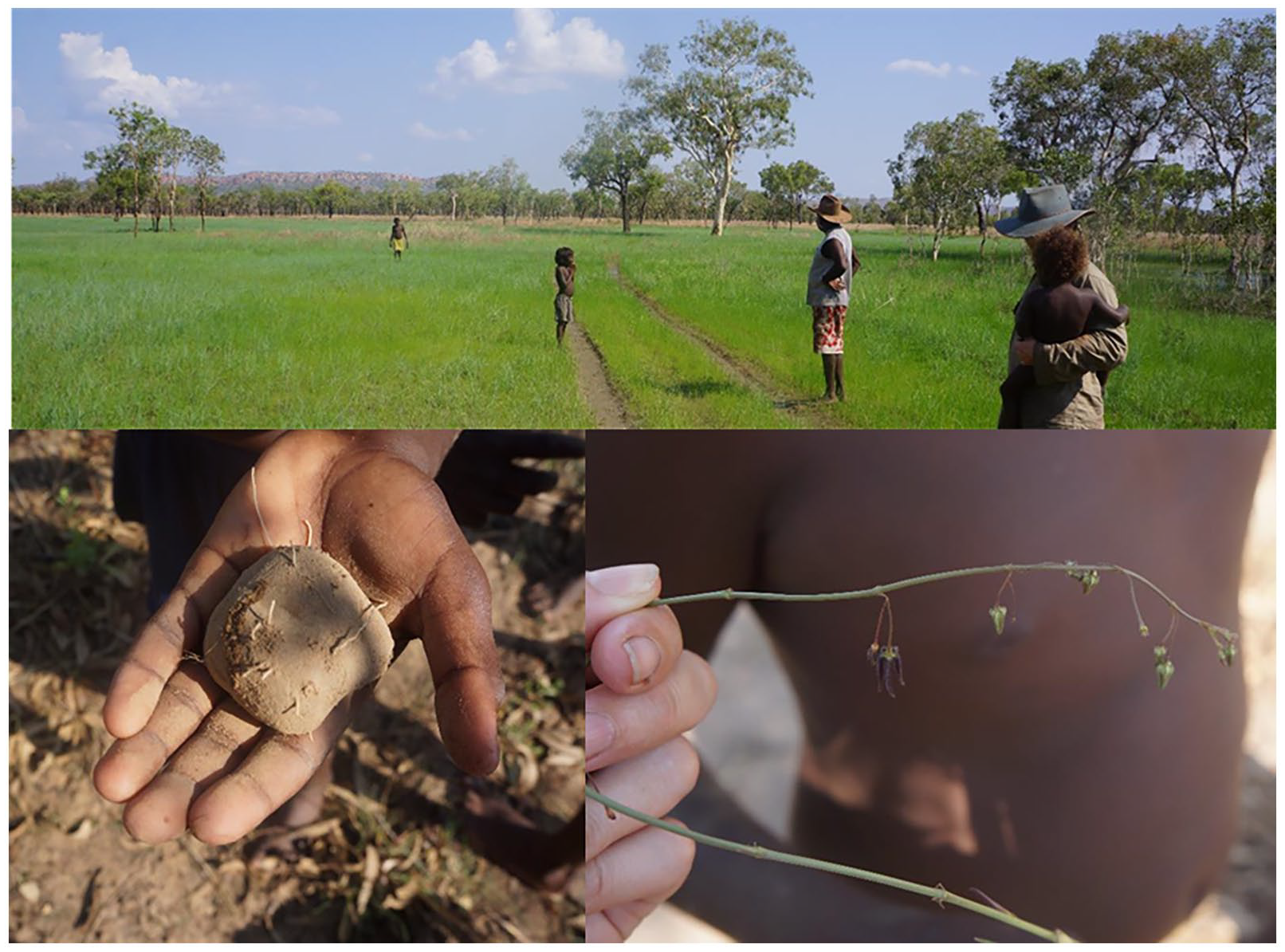
Looking for Marai (Brachystelma glabriflorum) Gadjerrong Country near Sandy Creek. Photos by J. Atchison.
Alongside such embodied sensibilities, we developed an awareness of mapping with Country as affective and emotional practice. Turning our attention to our mapping kit, unpacked weeks of planning, pilot testing and data management backup procedures, which seem to work, but are never seamless. Far from internet and reliant on intermittent power to recharge equipment, there is apprehension about the dust that has started to creep over the kit. The road through the community is only partly sealed with bitumen, and regular traffic throws up fine bulldust that permeates every crevice. Wondering how it will all work, animated conversations start to filter in. We share many humorous moments locating elements with the zoom function on the tablet. The children are enthusiastic and curious users of the technology, zooming in and out of the imagery and adding data points as they recognize features. As the dust settles in, Country works to motivate us and keep our focus on the bigger picture, and the reasons we are here.
Mapping with Country is emotional for us all when we start to talk about the plants and places we encounter. Some plants we meet are useful and recall a shared memory. Marai, a small lily with an edible underground tuber, emerges when the first rains come, Figure 2. It offers a delicious snack, and older community participants remember playing the game and looking for marai as children. Playing the game in our work together brought excitement, attentiveness and calm, and eventually, when plants were located, joy. The game prompted us to tune more directly into the emotions and affects Country was eliciting.
Sometimes for example, concerns are revealed slowly in the conversations that ensue after we sight a plant for the first time, or a plant in a new place. Talking though the encounter draws out knowledge of plants and their geographies. Our initial entry typology prompts us to classify this delineation early, but over time we learn to wait and see how conversations unfold before categorising. At other times, concerns are immediate, and we stop for visceral and heartbreaking conversations that bring sadness or worry, new weeds like Parkinsonia and Mimosa. Occasionally we arrive at places that haven’t been visited in a long time, and memories of the past come flooding through. These feelings, are surfaced through Country, noticed and discussed. Over time, feelings and anticipation of them, help to orient our work, as future deliberations are made about priorities and where to go next.
Mapping as emergent, performative practice
Over time, we have come to describe our work as mapping ‘on-the-fly’ because it captures a sense of the dynamic, mobile nature of working together. As noted above, it is an embodied and emotional experience. But it is also a practice that unfolds between people, and the more-than-human world at particular times. We can prepare for encounters. Never-the-less, it remains a process of the moment that we cannot predict with any certainty. Here, we describe mapping ‘on-the-fly’ as emergent and performative practice, because it involves certain kinds of movements, not only in and out of the car, but in tandem with Country.
The game ‘looking for marai’ was prompted in the car, when we passed through areas of Country where marai grows. The right time to spot marai is limited to the beginning of the wet season, after the first rains when the new green shoots emerge. At this time of year, the colour of the fresh stems and purple flower stalks of this otherwise indistinct plant, contrast to the surrounding brown dry grass, Figure 2. There is only a small window of time before the surrounding grass also flushes green, and you have to be moving through the landscape to see it. Only practiced eyes know when, where and how to look obliquely across the near distance while moving, in order to grasp its form. Moving in the car and looking across the near distance in this way facilitates a particular perspective of marai that is otherwise difficult to achieve. We didn’t plan to map marai. Instead, Bernadette and her father Maurice, and marai, and the car, and the computer tablet, and the children on the back seat, mapped themselves into our work.
Movement is central to mapping on-the-fly, but not intuitive to working with relatively immobile plants. The GIS enabled tablet, on which we record data from year to year, makes it possible to geolocate our observations with accuracy. This description of our work, however, feels somewhat static. Driving, and being in the car, means getting to grips with a particular dynamic of mobility in mapping significant. From the vantage point of the car, we gain height, and we see though angles filtered through vehicle windows; the oblique angles bring particular elements of Country, such as marai, into our purview. On the better roads, we can move as fast as the conditions will allow. When we go off road, our traversing is circuitous and slow as we take care to avoid rocks and sticks. But our vision through and over the long grass, especially from the front seat, is enhanced. When we are moving more slowly, we are more inclined to stop and get out to discuss what we see.
Occasionally, we will see something unexpected, or the movement of the vehicle will disturb animals, and the call to ‘back up’ or reverse the car, rings out. These vehicular manoeuvres can be moments for clarifying what has been sighted. At these instances, data entry can pause, though we might record what happens at its conclusion. Other times, we more deliberately take time out of the work to rest. Here, Country provides both the stimulus and tempo of how we move and choreographs where and when we find ourselves mapping to take advantage of the perspective that the car offers. We change direction when Country opens or closes opportunities, and we move on or linger in response to what ensues.
In attempting to describe the emergent and dynamic nature of mapping ‘on-the-fly’, we note also the small movements required to achieve perspective, which we illustrate through the analogy of viewing rock-art, Figure 3. To understand a painting, a viewer must make small adjustments, akin to climbing into the rock to re-orientate one’s body to acquire the perspective of the painter. Some rock art may only appear or be perceived at certain times of the day or year, when the sun illuminates figures otherwise hidden. Thus, the movements we describe are not just of ourselves, but of ourselves in relation to Country, to ancestors and to each other. These subtle movements reposition our bodies as we repeat and retrace our steps over the course of a day, and from year to year. We might trace pathways once only or set out to visit places only to abandon the trip – perhaps because Country is still wet and access impossible, something community members read as a signal that Country is not ready for us. Over time, we have come to recognize this embodied learning is an enduring feature. Including these aspects, rather than excluding them as ‘dead ends’, involves understanding that mapping with Country is something that is ongoing, and never quite complete. Mapping with Country involves repetition, cyclical movements across space and time, tracing, repeating and re-treading never quite complete trajectories.
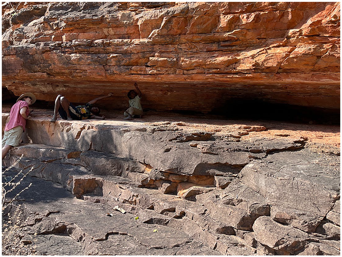
Mapping ‘on-the-fly’ with Country is a mobile practice of inscription that involves a shift in perspective. Mapping places us in new positions, with respect to each other and Country and illustrates Indigenous expertise in this process. Photo by T. Savige.
Mapping as political practice
The third dimension of mapping ‘on-the-fly’ we describe relates to change, which considers it as a process for documenting how Country is changing, and the changing nature of our mapping work responsive to community needs and interests. In the above description of positioning of our bodies, there is also a related political positioning with respect to Country that is necessary to explicate. In articulating mapping change as multidirectional, we thus call attention to the politics of mapping with Country, and its potential for affecting change.
Across northern Australia, weeds are driving distinct trajectories of socio-ecological transformation. Gajerrong Healthy Country Plan responds to the politics of natural resource and weed management that seek to engage Indigenous people, by supporting an Indigenous led response. It represents a small but determined effort by community not only to have a say in the forces of change that impact them, but to initiate and direct responses. But change can happen in surprising ways.
Initially, we set out to map invasive, rather than native, plants. In our first experience of playing the game together, looking for marai responded to the needs of the children that accompanied us. Bringing children along while we work is an important aspect of community life and how children learn from an early age; intergenerational knowledge transfer is a key priority for the community. At present, opportunities for learning are geographically limited due to socio-economic marginalization and a lack of financial resources enabling access to a car. The mapping project provides an opportunity to fulfil multiple needs, including intergenerational knowledge sharing. While working with children can present challenges, Bernadette knew how to dovetail what may otherwise be competing demands, recapturing the children’s attention, and refocusing the mapping work to their interconnected needs as part of Country. The GIS tablet often draws in the attention of the children who engage with the software and imagery. The children remind us that Country includes people and to consider how what we are doing works towards their future.
We have thus learnt to respond to what Country puts in front of us, and how it calls for, even demands, our attention. Widening our attention to the agency of Country, necessarily affects what we are mapping, allowing us to consider weeds, but also other plants as agentic, and embedded in a landscape of connections. 60 Our differentiated positionalities are important in this regard; non-Indigenous collaborators are always accompanied by community members for cultural safety. Cultural knowledge holders make it possible not only to read but to interpret Country in order to connect its meaning to people and their interests. Sometimes the non-Indigenous researchers facilitate access that would otherwise be difficult. One impromptu visit to the station homestead, usually the exclusive domain of white pastoralists, allowed us to participate unexpectedly, in a fruit gathering activity. This spontaneous harvest resulted in new tree seeds transported back to the community garden and ensuing discussions about weeds and other plants. Attending to these politics of positionality, helped the non-Indigenous researchers to recognize the ways Country re-territorializes particular relations between people and plants – in this instance, reconnecting community members with places they are often excluded from, and reaffirming their expertise through our work together.
Country directs where, how and what we work on together, drawing in questions of agency and power. Marai is a small, cryptic plant, but responsive to seasonal rainfall. It stores energy for the dry season, calling people into its sphere of influence and energizing them when the time is right. It reminds us to be responsive to opportunities in our mapping, as conditions, interests and needs change. Thus, our work generates new understandings of who and what matters in this place, and which plants and places we make space and time for, as we are mapping with Country.
Discussion
In this paper, we have sought to document and share our process of mapping with Country, contributing to revitalist cartographies. Mapping ‘on-the-fly’ annotates Gajerrong concerns for how Country is changing, and a concomitant desire to work with Country in responding to change. As such, it refuses a rationalist understanding of Country as something that might go onto the map, undifferentiated object, or separate to people, although it does not sit apart from the colonial context which brings it into being. Here we reflect on the implications of our work for cultural landscape and more-than-human mapping.
Mapping ‘on-the-fly’ necessities a reimagining of approaches that have traditionally been part of spatial data collection within cultural landscape mapping. Mapping while moving, talking and listening is a departure from a highly structured exercise with clearly defined bounds and objectives. Driving across Country while inputting spatial features, listening to one, or more, ongoing conversations, requires a certain creativity. 61 For example, a stand of invasive trees might be signified by a single spatial point with a detailed comment, rather than a polygon outline of their extent. The comments recorded may refer to; the approximate extent of the species, their size, health, attempts at management, risks posed, useful properties or disagreement between speakers on one or more of these topics. These are all elements Strang refers to as ‘contextual’ data. 62 In our case, all data is contextualized and data collection an attempt, however limited, to record relationships with these living elements of Country, providing a richer account than quantitative data alone can offer. 63 These elements are difficult, if at all possible, to capture using ‘traditional’ cartographic techniques, in part because they require a depth of qualitative data to be known. In doing so, mapping ‘on-the-fly’ dovetails what might otherwise be competing demands for detailed spatially locatable and quantitative information, with the richness of qualitative data provided through interviews and conversation.
The challenges of trying to ‘fit’ qualitative place-based and relational knowledge into categorical typologies, even when these are developed through discussion and collaboration, remain. A feature to be recorded may have qualities spanning the typologies defined by community, making it difficult to represent on GIS platforms that require specificity. The struggle to capture instances of cross-categorical data speak to a need for new ‘syntactic rules’ in cartography, 64 and the risk of glossing over such data through the uncritical use of GIS technology. One of our strategies has been to address such aspects as they arise, reflecting relational categories by creating new instances (points/lines/polygons) for alternative categories that can be grouped and cross-referenced once the data is brought into a desktop analysis programme. A plant may be a concern and thus annotated as a weed, but also recorded through other relationships as kin and/or as food. A second strategy we developed is allowing more time for a consensus position to emerge about what should be recorded.
More significantly, we came to recognize these struggles, as Wilmott refers to them, or syntactical ‘slippages’, as also part of the more-than-human agency of Country – instances where Country contradicted or confounded tendencies toward rationalist and systematic data organization and offered other directions. Avoiding the heat, we learnt to map while moving in the car, which required new approaches to annotating and joining details. Attending to the varying perspectives and multi-directional choreography of how we moved, led to repeating, abandoning, or retracing our paths, and to data checking. Responding to surprise encounters, enabled us to reflect community concerns to also develop intergenerational knowledge sharing. Here, Country presented to us in ways that did not fit easily within existing topological and spatial frameworks. We contend that refusing to work against or in spite of these vital agencies, is recognition of the relational dynamic of mapping with Country, involving embodied and situated responsibilities that we continue to explore. Our collaboration is in ongoing dialogue about how the data will be further shaped, analyzed and represented within the processes with which community seek to engage.
Acknowledging the agency of Country in mapping we argue, reflects a relational politics of inscription; how Indigenous people participate, and how distinct worldviews that may inform and structure processes are made visible. Mapping ‘on-the-fly’ requires the perspective of being in relation with Country, according to its syntax, to impress a particular mobile, and situated perspective. This perspective is contingent on the time-places that bring it into being, and the differentiated bodies and social relations that make it possible to attune to presences and absences, as well as their affects and implications. Practicing simple syntactical patterns, we have slowly been able to layer in more compounded, complex and conjunctive data entries that attend overtly to these relational politics, for example, to affective plants, like marai, that inspire people into action, new and/or resurfacing pathways which illuminate concerns, and tactical alliances between people and weeds which challenge management orthodoxy. These strategies have changed our perspective about what matters, since they require us to be open to uncertainty and personally implicated, such that our individual and collective relationships with County are registered. In this respect, mapping ‘on-the-fly’ annotates, through combinations of quantitative and qualitative entries that include the bodies, emotions and experiences of the mappers, the political force of Country revealing itself. It offers therefore, legitimacy to Gajerrong intergenerational knowledge sharing, and to the possibility of accounting not only for plants and Indigenous knowledge about them, but for the relations of which they are a part of, as Country.
Conclusion
Juggling the demands of Country and culture for natural resource management, with the pressing needs of intergenerational knowledge transfer, can be challenging, and present significant risks for Indigenous communities. In this respect, our purpose in documenting and sharing our process has been to provide inspiration for others to consider whether and how mapping may facilitate community aspirations and needs and reflect diverse relationships with place. We hope it will nurture the collaborations that may be required to do so, including those with Country.
Footnotes
Acknowledgements
JA acknowledges Gajerrong Country as ever present in her work. We all acknowledge Gajerrong Country and members of the Marralam Community who have participated in this project, and all those who have supported the work of our collaboration. We thank Rob Leary from the Northern Land Council for continued practical support and advice while we are in Kununurra. For field and research assistance in 2022 and 2024, we thank Maddi Isabella and Laura Hammersley. For research support in Wollongong, we thank colleagues at the Australian Centre for Culture, Environment, Society and Space (ACCESS).
Funding
The author(s) disclosed receipt of the following financial support for the research, authorship, and/or publication of this article: Funding for this project is made available from the Australian Research Council FT200100006.
Ethics statement
The research reported here is goverened by an approved protocol administered by the Human Research Ethics Committee of the University of Wollongong, Australia. For legal and ethical reasons, the research dataset for this project is not publically available.