
Abstract
This article introduces inland waterway guidebooks as cultural objects that deserve further attention from cultural geographers who have begun to shed light on inland waterway cultures in recent years. It contributes to the wider disciplines long-standing interests in representations and representational objects, and more recently the interest in studying representations and their relations to everyday forms of practice. Focusing on a popular series of waterway guide, the Collins/Nicholson Waterways guides, I employ textual and visual analysis alongside an autoethnographic account of using these guides to examine what waterway guidebooks are, how they represent waterway spaces and how they are used in the practices of wayfinding on a narrowboat. By doing so I argue that waterway guides are powerful objects of representation that can tell us much about how waterway spaces are represented and how they are experienced with a guide in hand from the perspective of boat users. In laying out these arguments, I build on the notion of the travelling landscape-object to develop a theory of cruising landscape-objects, which I define as waterway guides that both represent, (re)produce and circulate waterway spaces at the same time as they are representational and material objects that can co-constitute wayfinding practices on the water.
Keywords
Introduction
The UK’s inland waterways (canals and rivers) have received attention in the academic literature as well as in popular televisions programmes, books and industrial heritage exhibitions and museums. Much of this work has focused on the history of canals and ‘canal mania’ during the industrial revolution and their subsequent regeneration as leisure spaces in the latter half of the 20th century.1,2 More recently their aesthetic and socio-economic role in waterside urban regeneration projects has been studied. 3 Although this work has done much to highlight the broad changes in canal use and culture; exposing the history and cultures of canal users, as well as cementing canals as a key part of the British national identity (for some), very little work has focused on the minutia of everyday life on canal boats and the materialities that constitute it. 4 Indeed, it is only in recent years that research from geographers and anthropologists has begun to explore these quotidian and material aspects of waterway life.5–9
This paper makes a contribution to the literature on the materialities of everyday life on Britain waterways from the perspective of cultural geography, by examining popular inland waterway guidebooks as representational artefacts that combine narrative and descriptive text, maps, navigational advice, tourist information, photography and diagrams. At a time when Britain’s inland waterways are attracting large numbers of visitors and dwellers, as well as receiving a great deal of media attention and funding for restoration, 10 I argue that it is important to consider what role popular waterway guides play in (re)producing geographical imaginations and shaping everyday practices in these spaces. I demonstrate that these guides offer representations of life and travel on the water at the same time as being tied up in the material practices of wayfinding on the waterways. With regard to the latter, I show how engaging with waterway wayfinding challenges the popular assertion that digital maps have become the navigational tools for contemporary mobilities. I unsettle the notion that digital maps have simply replaced the paper map on inland waterways, and continue to develop the idea that mapping practices are always situated in specific socio-material assemblages.
Whilst the aforementioned work has begun to examine the materialities of dwelling on waterways, the literature on how life on the waterways is represented in popular guides and how one moves through waterway landscapes with these guides remains scarce. This is despite the efforts of those examining tourist guides and tourist writing in other areas of the discipline. To rectify this, the paper deconstructs inland waterway guides firstly as representations, and then analyses them from a performative perspective to reveal insights into the way that waterway culture is represented and lived.
The article begins by briefly reviewing the history of waterway guides, especially those produced during the post-war leisure boom in canal culture. I then frame my textual and visual analysis of these guides by drawing on the concept of the travelling landscape-object, which Veronica Della Dora has defined as ‘portable graphic images embedded in different material supports which physically move through space and time, and thus operate as vehicles for the circulation of places; worlds in miniature visually and physically possessed by the beholder and yet able to exercise their own agency’. 11 I argue that this theoretical framework offers a useful means for analysing how and why the material and representational properties of these guides matter in circulating geographical imaginations of waterway spaces. Finally, I shift to a performative mode of analysis by providing autoethnographic vignettes of wayfinding-with-a-guidebook on the UK’s inland waterway network between 2015 and 2019. By doing so I suggest that the waterway guides may also be conceptualised as cruising landscape-objects that travel with users, and also shape their experiences of boating through the landscape as a distinct form of ‘slow mobility’.
Post-war inland waterway guides
In pre-war Britain, waterway leisure guidebooks such as the Salters’ Guide to the Thames (1891), The Oarsman’s and Angler’s Map of the River Thames from its source to London Bridge (1881) and the now infamous Guide to the Lakes by William Wordswoth (1810–1835) brought together strip and fold-out maps, tourist information, boating timetables, scenic descriptions, fiction, poems and imagery about the UK’s rivers and lakes. At the same time, itinerary books containing maps and diagrams were commonly used by commercial canal companies for inspection and maintenance purposes (see, for example, the Sheffield and South Yorkshire Navigation Company’s ‘Canal Inspection’ guides dating from the early 20th Century). This is to say that waterway guides are nothing new, have not only been produced for leisure and tourism, and have not only been aimed at canals or rivers. Nonetheless, the post-war boom in leisure and tourism on Britain’s inland waterways sparked a new wave of guidebooks that catered specifically to leisure activities, be that boating, walking, cycling or other. 12 This shift can be roughly marked by the establishment of the British Waterways Board (BWB) in 1962 and the public funding made available by the Barbara Castle Transport Act of 1968, which are commonly understood to be the turning point for canal restoration in the UK.
Guidebooks produced after 1962 are notably different from those produced before the Second World War, with the shift most clearly seen in the way that they began to mirror the form, content and style of the general-purpose pocket travel guides being produced at the time. In contrast to the narrative descriptions of journeys down one river or aquatic region identified in pre-war guides, these guides closely resemble the bricolage of representations that we have come to associate with travel guides; combining maps, practical information, landscape descriptions, navigational assistance, restaurant, café and pub recommendations, useful telephone numbers, directories, places of interest, commercial advertisements, information boxes and scenic photography in formats ranging from tall and portrait hardbound books, to soft and ring bound books with a landscape orientation. Similar to other travel guides, they quickly developed as commercial enterprises aiming to satisfy the market for cheap and easy to use guides.
The market for waterway guides is now large and diverse. Some are general guides aimed at boaters, some at walkers and cyclists, whilst others are designed to appeal to all user types at once. In addition to these, there is market for boater manuals and handbooks, waterway maps, photographic guides and coffee table books which depict waterway life in high definition on glossy paper. What we can gather from this is that they are not only designed for and used by tourists. Many regular visitors of the waterways make use of them, as do those that live on the waterways. There is no one-size fits all definition for guidebooks due to the complex and contextual ways that they are embedded in the lives of the advanced and amateur traveller alike.13,14 And yet, many of us continue to assume that we know what a travel guide is and why we would want to use one or not.
Collins/Nicholson waterway guides
For the purposes of this article I will focus on general waterway guides designed primarily to be used by boaters, walkers and cyclists as they move along inland rivers and canals. Specifically, I will focus on the Collins/Nicholson Waterways Guide series (Nicholson guides hereafter), which are often described as the most popular of these post-war guides (see Figure 1). 15
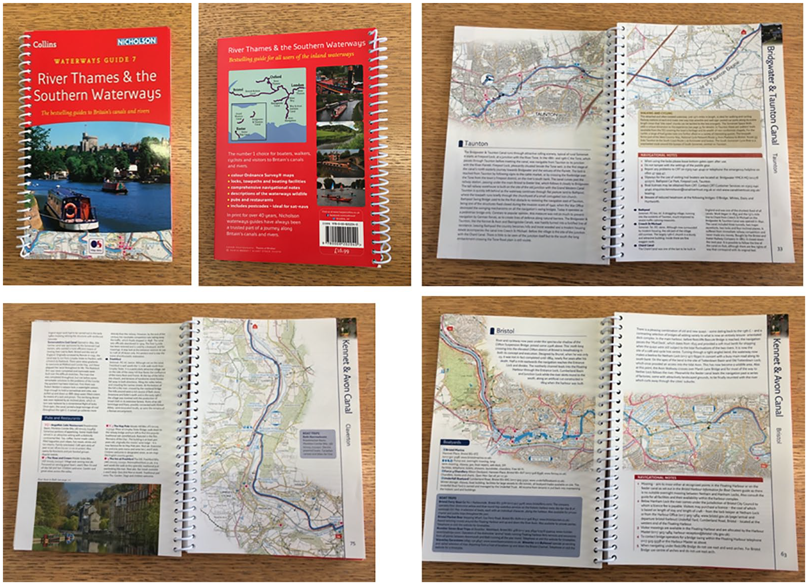
The Collins/Nicholson’s Waterways Guide 7: River Thames & the Southern Waterways (authors photo, 2020).
Surpassing other notable publications including the BWB’s British Waterways Inland Cruising Booklet (sometimes referred to as the BWB ‘Bluebooks’), the Pearson’s Canal Companion series, Imray guides, and Heron Maps, the Nicholson guides that originated in the late 1960’s and early 70’s after the BWB commissioned Robert Nicholson to produce a series of four guides to Britain’s inland waterways have become travelling companions to many users of the waterways. 16 In the following section I situate these guides as ‘travelling landscape-objects’ and question why it is that they have yet to receive attention from cultural geography and then how we might understand their use as representational objects that are important to waterway culture.
Travelling landscape-objects
Cultural geography has a long history of studying representations and representational artefacts, often situating them in terms of the imaginaries, cultures and politics of the spaces and places that they depict.17–19 More recently, the discipline has become accustomed to examining representations and representational artefacts from relational and more-than-representational perspectives.20–22 There has also been interest in examining representations and representational artefacts from more-than-human, 23 object-oriented 24 and networked perspectives. 25 Throughout this interest in the role that representations play in cultural practices, inland waterway guides have been understudied by the discipline. This is a curious omission, especially when we consider the wide range of representations that are included on their pages; descriptive text, navigational advice and instruction, tourist information, utilities information, maps, diagrams, tables, index’s, photographs and other imagery. This is highlighted further still when we consider the attention the discipline and the wider cultural studies field have given to travel writing and tourist guides, which include many of these aforementioned representational forms,26–32 and the attention the discipline has given to canals and canal culture in recent years.33,34
In the field of critical cartography, a similar pattern has emerged whereby maps have been recognised and studied as powerful representations with agency to affect understanding of space, place, culture and politics,35–38 as artefacts with more-than-representational performative capacities,39,40 and more recently as material objects that act in the world, in and of themselves. 41 As maps and diagrams have long been central to waterway guides, it is similarly interesting to note their absence from this literature. Indeed, many of the claims made about maps could be applied to these guidebooks; they are representative of certain spaces, places and cultures, are not apolitical, have a capacity to evoke performances through use and can be regarded as cartographic objects with their own life trajectories. In light of these absences, this article attempts to situate inland waterway guides within these two bodies of literature, to examine them as (1) socially produced representational artefacts (2) objects with a materiality that matters and (3) objects with the capacity to evoke performative practices.
I employ the theoretical framing of the ‘travelling landscape-object’ as one way to situate waterway guides as representational artefacts with performative capacities that are realised through mobile practices. There are many other ways these guides could be studied, for example as ‘cartifacts’ that have agency in a wide range of social contexts that are not even directly related to canal life. 42 Equally there are many other ways in which the contexts of their use could be examined to analyse where they are used, why they are put use, and by whom. 43
Following Della Dora’s use of the term, cultural geographers have paid much attention to examining landscape representations as static visual texts, but there is further scope to examine the materiality of representational objects that travel between actors in different space-times. Waterway guides are notably different from the portable graphic images Della Dora identifies as travelling landscape-objects (e.g. postcards, paperweights and paintings), in the way that they are more than just graphic representations of the landscape. Yet they do share some of the key properties that she identifies. They include graphic images, are embedded in different book forms (in term of size and structure) and do travel through space and time as circulating references of the waterscape as guides are exchanged, stored and revisited as souvenirs. 44
I argue that the Nicholson guides are travelling landscape-objects because they depict, circulate, and bring to the surface geographical and historical imaginations of waterway landscapes. By restricting my analysis to only one guide in the series, I follow Vincent Del Casino and Stephen Hanna’s deconstructive approach to ‘reading’ maps, where close attention to one artefact can be considered representative of a wider series of representational objects that have a similar form and style. 45 I also build on the suggestion put forward by Victoria Peel and others, that a focused analysis and close reading of guidebooks is necessary for unpacking their agential capacities. 46 By examining one edition of the Nicholson guides, we can see how format, style and narrative tone effect what kinds of cultural landscapes are represented through these artefacts and what kinds of geographical imaginations are brought to the fore through their use. The specific guide chosen is the Waterways Guide 7: River Thames and the Southern Waterways (2017). At the time of writing, this is the most recent edition of guide 7 and is therefore evidence of what the guides represent today.
Representing rural idylls and industrial heritage
Rural idylls and the materiality of urban-industrial heritage are prevalent in the images, maps and text throughout the guide. There is very little recognition that the British countryside is anything but natural, and only passing recognition of the industrialised past beyond its material legacy. It is very much a representation of the waterways through historical facts, architectural details and landscape description. What the reader gets is an ‘objective’ and pragmatic narrative of what can be seen as one travels along the waterway. This is seemingly how the author wants to represent the waterways through the texts, maps and photographs. Indeed, there is very little evidence to suggest that the author wants to engage with complex social histories and imaginations of either. The photographs in Figure 2 are indicative of this in the way they intend to simply represent waterways as leisure spaces steeped in British industrial heritage.
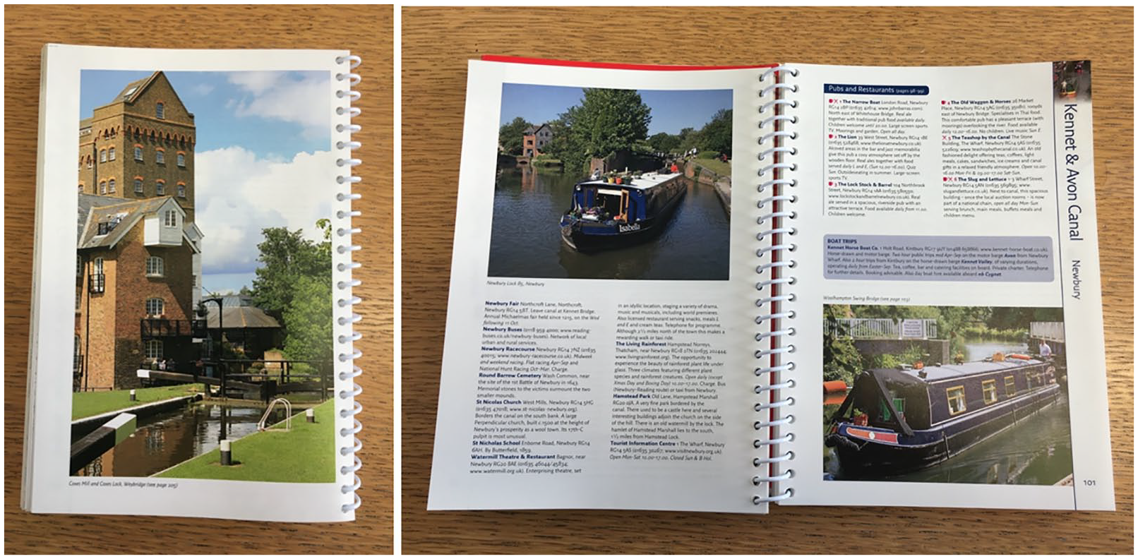
Examples of the photographs found inside the Collins/Nicholson guides. These are representative of two themes in the guides (1) waterway spaces as part of British industrial heritage (2) waterways as leisure spaces (authors photo, 2020).
This is perhaps unsurprising, for as Bouke van Gorp has argued, guidebooks trade in notions of assumed objectivity and authenticity. 47 They are designed to paint a picture of certainty and represent stability amongst the other uncertainties of travel. In short, to offer a nuanced and critical analysis of the landscape is certainly not what waterway guides were designed for, nor is it what readers are probably looking for. To give a flavour of this, I include an excerpt below from the Tadpole section of the guide (p. 116).
Tadpole
A very isolated, rural stretch of river, meandering through meadowland and having little contact with civilisation. The river divides at Radcot where two fine bridges, the ever popular Sawn Hotel and a large picnic area opposite are always busy with visitors on summer afternoons. Caravans line the north bank as once more the Thames enters open meadowland around Radcot Lock and then meanders on to the splendid Rushey Lock, with its charming house and fine garden, and the handsome 18th-C Tadpole Bridge. Then again the Thames enters lonely country, passing to the south of Chimney. It is about as far away from it all as you can get on the river.
The guide’s descriptive tone follows a style guide going back to the early days of its publication. Moreover, the inclusion of Ordnance Survey (OS) maps gives the guide a reassuring stamp of authority that the spatial information described and shown is accurate and useful. What is interesting about these maps, which have been licensed from the OS to include additional design features that are unique to Nicholson brand, is how they are used to highlight points of interest and importance that are assumed to be related to waterway culture. For example, as seen in Figure 3, the guide pays particular attention to representing pubs as prominent sites of interest. As in other studies of maps, 48 what we see here is how a popular guide may both represent features that are important to users, and also reproduce the notion that pubs are intrinsic to waterway culture.
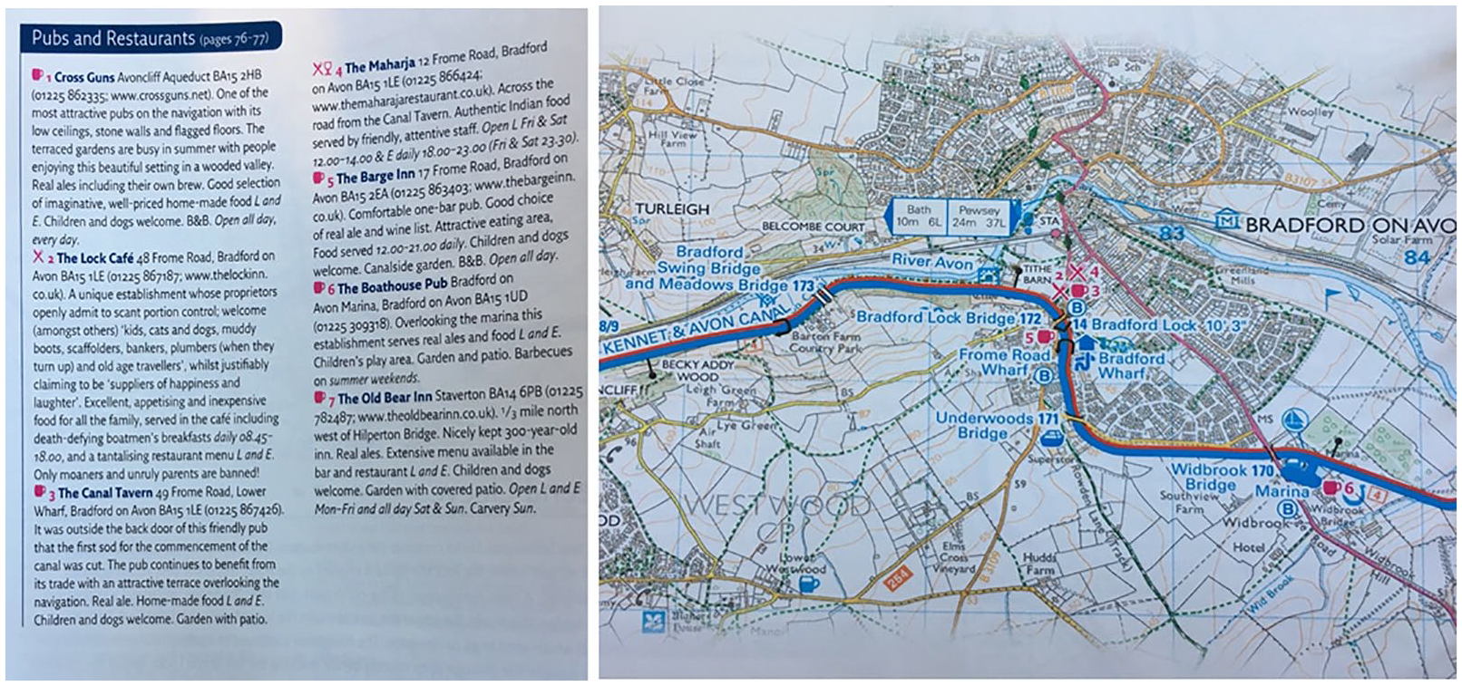
Pubs listed in relation to how they are represented on the map, indicated by a beer glass symbol. Taken from the Collins/Nicholson’s Waterways Guide 7: River Thames & the Southern Waterways (author’s photo, 2020).
In addition to and in close conjunction with representations of heritage, the guide also reproduces stereotypical views of waterway culture. Though they are not only used by tourists, we can say that they structure the tourist gaze in a similar way to other guidebooks based on practices of ‘othering’.49–51 This is done by imagery that situates boating and countryside rambling as a quaint and leisurely activity done by the middle classes, through the inclusion of pubs as one of the most prominent point of interest for readers, and through the narrative description, which paints a picture of waterway travel through urban and rural England that escapes the realities of social life that might be happening just a stone’s throw from the tow path. Again, this is likely intentional for the market they are trying to attract. Nevertheless, such representations play with the space-time of waterway culture, depicting it as a stable leisure practice, which it may be for some, but which it clearly is not for all. As the work of Titika Malkogeorgou has shown, the space-times of waterway life are much more complex than these representations would suggest. 52 She makes it clear that there is rarely anything static about life on the waterways, nor is there any one culture that can claim the waterways as their own.
Following Della Dora, landscape-objects must be regarded as more than simply ‘visual texts’ and instead must be considered as traveling objects with agency to warp and shift space-time. 53 By highlighting some of the representations in the Nicholson guide, I suggest that the guide does have an agency to warp and shift contemporary space-time in ways that summon the past to the present as well as disrupting the complex realities of the geographies that exist along the waterways. This is done through narratives that bring to the fore the industrial heritage of the waterways, through imagery that conjures imaginations of life once lived on the waterways and through the maps printed on each page, which represent points of interest tied closely to the waterway’s heritage and stereotypical image.
Nevertheless, we must be critical of the interpretive approach taken here. 54 Victoria Peel and Andres Sørensen note, ‘much textual analysis [of guidebooks] frames the reader – the tourist user – as predisposed towards unconditional acceptance of the messages conveyed in words or photographs unmediated by any personal understanding.’ 55 We certainly do not know for sure the myriad ways in which the representations in these guides are viewed and understood by users, and further research is needed to study the work that these representations do in producing geographical imaginations in those that use them. What I hope to do in the next section is to draw on my own experiences of using the Nicholson guide in an effort to demonstrate an example of how they may be received in the practice of using them for wayfinding.
Cruising landscape-objects
In an effort to address the gap ‘between the landscape we walk through and activate through performance, and the landscape of portable graphic representations’ that Della Dora identifies, 56 I argue that waterway guides can be also be described as cruising landscape-objects, where ‘cruising’ replaces ‘travelling’ to suggest that waterway guides are designed to go-with those ‘cruising’ the waterways. 57 This diverges from Della Dora’s landscape-object, where ‘travelling’ describes the process of how material objects are passed from one actor to the next through different space-times, often disconnecting the landscape represented on/in the travelling object with the site in which it is viewed and used. In my use of ‘cruising landscape-objects’ I suggest that this gap can be bridged if we examine the work that waterway guides do to connect those using them with the landscapes that they pass through.
I argue that waterway guides as cruising landscape-objects are not only ‘primary currencies for the circulation of place through space and time’, 58 but are also currencies tied to the mode of travel, for revealing the emergent spaces, places and imaginations of the waterway landscape as one moves through it. Similar to how maps have been studied in relation to the situated wayfinding practices of their users,59,60 further attention should to be paid to how waterway guides, which offer more than the map, travel with and guide users in situated mobile practices. Building on the notion that maps are ontogenic objects that are always coming into being, 61 I argue that waterway guides are also processual objects that come into being (e.g. becoming navigationally useful) as one moves along the water and through the landscape. This is further tied to the notion that waterway landscapes and our imaginations of them are equally ontogenic, ushered into being through the repetitive process of translating information – in this case from the guide – onto the environment in front of us.
By taking this processual approach I hope to shed further light on the broader relations between mobile practices, navigational visual objects and their materialities. To date, many have shown how maps shape wayfinding, but further attention should be paid to how such objects, and the specific socio-material assemblages in which they are used, shape mobile practices and geographical imaginations of the landscape. Wayfinding mobilities must be seen as a contextual practice that emerges over time with navigational visual objects, the mode of mobility, the material environment travelled through, and as a socio-historical practice that is contingent on who is present. I argue that my analysis of cruising with the Nicholson guides is illustrative of the interplay between these interlocking elements, and could push wayfinding studies forward by calling for more contextual studies that focus on how reading maps and the landscape relates to the socio-materialities of mobility modes and social situations.
In the following autoethnographic vignettes, which describe my own experiences on the UK’s inland waterways, I attempt to clarify this by showing how wayfinding on these waters is a practice shaped by the materiality of the landscape and its multiple relations to the guidebook. These vignettes are taken from four successive summer trips on Beatty between 2015 and 2019 where I kept an intermittent diary of what I used the guides for and why. On these trips we cruised the ‘Leicester Ring’, the ‘Avon Ring’ and the ‘Warwickshire Ring’ (popular two-week canal trips in the Midlands of England) and stretches of the Kennet and Avon canal, the Leeds and Liverpool canal, the Llangollen canal, and the Trent and Mersey canal.
The autoethnographic approach was adopted as a way to uncover the minutiae of situated and performative guide-practice, which is an approach not generally taken in studies on guides, where attention has instead been given to content analysis and interviewing participants before or after trips taken. 62 I did interview Johnathan Mosse, the current editor of the Nicholson guides when carrying out the research for this paper and his insight was very helpful, but As Tessa Muncey has argued, taking a reflective look at one’s own practices can provide a rich source of detail that other types of qualitative research such as interviews, focus groups or participant observation might neglect.63,64 I followed others in the discipline here, who have used autoethnography as a situated method for examining the embodiments of moving through and being in the landscape. 65 Muncey’s point is not that other methods cannot access these details, but that they can be particularly difficult to draw out of research participants. Moreover, as Chris Perkins suggests in relation to mapping practices, 66 autoethnography, or what Giada Peterle calls the ‘auto-cartographic’ perspective, 67 can be valuable in assessing the performative aspects of what one does with the map in situ. Although autoethnography is limited in the sense that in only captures and selectively represents my personal experiences, I contend that it remains a useful method for drawing attention to the situated and nuanced experiences of using a waterway guide and demonstrating how it travels as a landscape-object.
Knowing as you go
Time and distance are judged by working with the guide as we move through the space it represents. More precisely, Elle and I calculate time and distance by how many bridges, locks and mile icons we have ticked off the map, or how many pages we have turned over (3-5 on a typical day if there is not too many locks is the message passed on from Elle’s Dad). The numbers adorning each bridge and numbered on the map become important landmarks here, for they act as frequent, reliable and material reference points that we see approaching and disappearing as we cruise beneath them. When I first started on the canal boat, I was struck by how much attention I paid to these structures, which in other contexts would have barely any significance to me at all. These numbers, along with the bridges themselves, quickly became the symbols that I used to calibrate my understanding of time and distance, which when travelling at 4mph, is a very different calibration than when travelling at faster speeds in other vehicles.
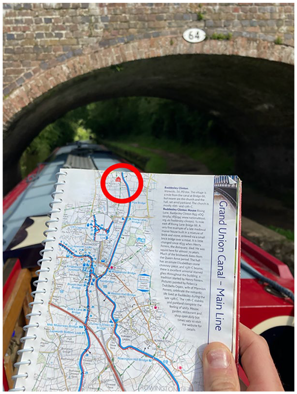
If we are both on deck, approaching bridges often has one of us looking up before turning to the guide to see which number it is in relation to that which is represented on the map. We either look first at the bridge for the number, which is usually centrally adorned at the peak of the arch (see Figure 4) and then locate it on the map, or locate it on the map and then look for the bridge. Standard OS maps are fairly useless here because they do not include the bridge numbers or mile icons included in the guide. Google Maps is also useless in this situation because it does not have any functions for canal boat navigation, no estimated time of arrival or waterway traffic overlays. Even with mobile signal, which is sketchy along much of the rural sections, the physical guide has more immediate practical use for us. It is always to hand, and importantly, easy to use whilst steering the boat. Fiddling with my phone requires more attention, not only because I might have to zoom in and out of the map and type in search queries, but more likely because I am distracted checking emails and choosing which podcasts to listen to. . .
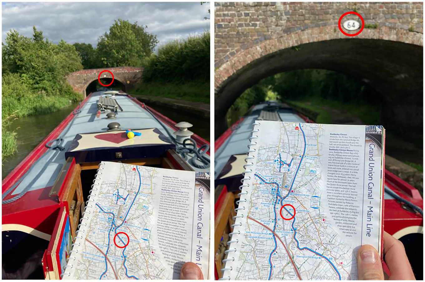
A numbered bridge (64) crossing the Grand Union canal. The numbering can be seen on the white and black iron plaque that sits above arch at the centre of the bridge. This number corresponds to the numbering on the map in the guide (author’s photo: June, 2019).
Tim Ingold has said that phenomenological knowledge and perception of the environments we live in can only truly be developed by our movement through them. 68 In the case of inland waterway environments, I developed my knowledge and perception of them by moving through them and taking notice of signs in the environment and symbols on the maps; something that is further understood through repeatedly moving through them. Speed and temporality of movement is also key here. By moving slowly through the landscape, as one does on a canal trip, I engage with the material environment in distinct ways. Structures like bridges get more attention and focus as I see them on the map, approach and cruise beneath them. This is a different kind of engagement between the map, mode of transit and the landscape compared to other forms of wayfinding such as when driving.
In this sense Waterway guides, as cruising landscape-objects, are spatially and temporally bound up in how the water wayfinder ‘feels his [their] way’, 69 for they act as part of the material and representational apparatus that we used to guide ourselves from one point to the next. As I have described, this process involves studying the guide in relation to the material environments that we pass through. It is also a process similar to that recognised in studies of how we use maps for navigation and wayfinding, where it has been shown through ethnographic and video-analysis that navigation is a process that emerges through frequent negotiations between what is represented on the map and the material environment that one moves through.70–72 Much of this work goes beyond Ingold’s initial approach to environmental perception by highlighting that wayfinding is also a social process where who we are and who we are with determines how it unfolds. 73 Reflecting on my experiences of being on the boat with the guide, I should also highlight how the presence of my partner affects much of the aforenoted experiences in ways that would not be the same if I were always by myself.
Finally, the vignette describes wayfinding as process of working with the materiality of waterway environment; namely the numbered bridges that we pass under. In other studies of wayfinding it has been recognised that landmarks play a role in how we navigate. Whether it be iconic buildings in the city, 74 stars overhead, 75 or landscape formations, 76 material markers are used to guide the wayfinder along a route that emerges in situ. This is not to say that the skills required to work with markers and the degree of difficulty in navigating different landscapes is all the same. The canal is clearly not equal to other environments that are far less constrained by concrete and stone channels. Instead, it is to say that all environments, even those as seemingly stable and straightforward as canals, do require the wayfinder to perform cognitive work with the environment and material objects if they want to get anywhere. Similar arguments have been applied in semiotic approaches to environmental perception, where knowing as we go is said to be process that emerges through our relations and responses to signs, be they social, material, human made or ‘natural’. 77 In this case the signs at the forefront, but by no means containing these wayfinding experiences, are those of and in the guide, the waterway channel and the numbered infrastructure of bridges and those that emerge socially between me and my partner, Elle. There are also similarities here with those that recognise our cognitive practices as always-already extended and connected with the environments that we move through and the technologies that we have to hand. 78
Guidebook materialities
Following on from this analysis of wayfinding, I now want to take a closer look at the guide itself. By paying close attention to the material form that the guide takes we can expose how its size, bindings, page structure, orientation and durability also shape wayfinding practices. In the following vignette I demonstrate the importance of the guide as a cruising landscape-object.
Usually it lies on the metal toolbox or seat in front of me, encased in a plastic folder if raining and out in the open if not. It can be seen all over the boat throughout a typical day as one of us picks it up, flicks through to see where we are and drops it down again. This leads to frequent calls of ‘have you seen the book?’ (see Figure 5). The pages of the guide are not always linearly structured nor used in a linear fashion because the guides cover canal regions rather than necessarily individual canals. On pages where one canal joins another, the guide is forced into following one, which means the other is relegated to some other part of the guide, or even another book. You need to pay attention to the numbered arrows that direct you to the next logical page or you risk ‘choosing your own waterway adventure story’ rather than continuing on the same canal you thought you were on (see Figure 6). This is further complicated by the changing orientation of the map and text on the pages, which change from landscape to portrait according how the canal relates to North (always at the top of the page). The result is that one is often flipping back and forth between pages. This, however, is made easy by the spiral binding of the book which allows for quick transitions without any worry that you might lose the page you were on. The spiral binds are especially useful when steering as it means you can easily fold the book in two and hold it one hand while the other is on the tiler. Not all guides have this small but significant feature; some for example, use larger folder out formats that although useful for planning purposes, would make them cumbersome to use while steering.
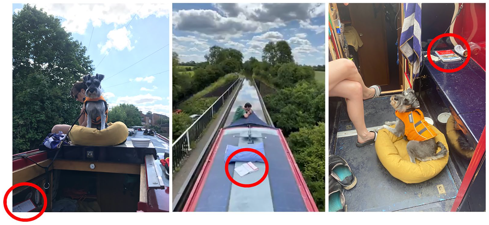
The Nicholson guide follows us around the boat as it is called into use. It gets left where it was last used and brought back into navigational use as and when its required (author’s photo: June, 2019).
The structure of the guide is not always linear. Rather than progressing chronologically through the book, the numbers on the map guide the user to the next logical page (author’s photo: June, 2019).
As this vignette describes, the different materialities of the cruising landscape-object matter for how it is used. This is supported by others in the discipline, whom have demonstrated how and why the materiality of representational objects should be considered in our analysis of them.79,80 In more recent work on the materiality of maps and mapping practices we can also see parallels with the waterway guide, not least because maps feature prominently in them. Tania Rossetto has shown that using a map is a tactile process whereby the materiality of the map, and especially its surficial properties are significant to how and why it is used as a cartographic object. 81 Her focus on how we engage with maps through touch, haptics and tactility resonates with the experiences described above. That I place great significance on the seemingly banal plastic spiral bind and handy size to work the guide is an indicator of the importance of the materiality of these representational objects. The tactility of the guide makes it more attractive to use as a cartographic object than say a digital map presented on a smartphone, which forces a different kind of tactile engagement that is not so simple when steering the boat. At a time when digital mapping and GPS technologies continue to transform other aspects of our daily wayfinding practices, the material and performative geographies of boat journeys have not been untouched by this shift. Nevertheless, they remain thoroughly (and sometimes necessarily) entangled with analogue mapping practices and learned wayfinding techniques, which deserve further attention.
Even in a world of prevalent digital mapping technologies and the seamless ease-of-use that we expect from them, the materiality of the map surface and the situated ways that it is engaged with shape how and why it is used. 82 It is not so simple to deduce that digital maps are always easier to use than analogue alternatives, despite the assumptions made (and sold) that digital technologies are always more efficient technologies. Collectively their work shows that the materiality of the map is not to be overlooked for it is often central to how we orient ourselves in space, how we align the map and what value we give to the map in a given context. I suggest the same might be said about paper guides in the context of wayfinding on the boat, where the usually appreciated affordances of digital alternatives can become cumbersome tools in comparison.
Map/text/image relations
Until now I have focused my analysis on the relationship between the form and content of the waterway guide, and how both were used with the landscape as I moved through it. In this final section I turn my attention to the examine the content of these guides, to analyse the different representations on the pages of the guide and how they relate to each other in the practice of wayfinding. In the following vignette I demonstrate how I work with the map and the text:
Turning a new a page begins with a glance at the map and page numbers before scanning the text to look for navigational instructions, which are embedded in the narrative descriptions on each page and more precisely in the ‘navigational notes’ boxes that sometimes feature. Sometimes there is little to read or think about such as when the channel in front is straight, quiet, and without locks or bridges. At other times the water in front can seem a lot more complicated than I anticipate; this is at odds with the tranquillity I used to associate with boating! Shallow areas, strong currents, weirs, narrow passing areas, stubborn lock gates and paddles are all things to look out for in the text; they are all things to upset the imagined tranquillity and have the potential to create stressful situations. When I spot something significant in the text, I cross reference with the map and my location (determined by a bridge) to come up with a plan. This gathering of spatial information becomes acutely important when steering solo, but much easier when sharing the load with Elle.
An example of this navigational instruction can be found in the guide to the River Thames and Southern Waterways (2017: 107), where the text warns boaters to be wary of a strong weir beside Fobney Lock on the Thames in Reading:
2. Fobney Lock – care should be taken when using the landing stage below the lock as a strong weir stream flows at right angles 3. To operate County Lock 106 it is advisable to first moor under the Inner Distribution Road Bridge, on the east side, to drop off crew to set the lock. Once prepared, power into the lock to avoid being swept to the west side of the river, towards the weir and away from the lock entrance
The map-text relation described here reveals something of how these guides are intended to be used as tools for wayfinding, and a little about how navigating with the map is a process of anticipating and mitigating for possible risks. 83 Van Gorp’s analysis of tourist guides recognises the variety of ways that information is structured and laid out in these books, from those that favour full page photographs and information boxes to those that favour rich textual descriptions or short bullet points. 84 The information lay-out of waterway guides is distinct in way that text, information boxes and images often surround or wrap around the map that takes centre stage (see Figure 1). As Wiebke Ramm’s study of travel guides found, ‘some guides keep text and maps strictly separate whereas others make extensive use of cross-referencing, often by means of numbering items referred to in the map and in the text.’ 85 This is certainly the case for the navigational advice and instructions that are present through the Nicholson guide, though it is the narrative descriptions in the text that can be seen on the map rather than the numbering of items.
Conclusion
Inland waterway guidebooks are understudied cultural objects that can reveal much about how waterway spaces are represented and lived. In this article I have theorised a popular series of these guides as travelling landscape-objects (following Della Dora) and as cruising landscape-objects in order to analyse them as both representations of the waterway landscape and as objects that may be used to reveal the waterway landscape as one moves through it. By doing so I have demonstrated that these guides should not only be regarded a objects which represent and circulate certain historical and stereotypical geographical imaginations of the waterways, but also as representational objects that co-produce specific wayfinding practices through the landscape.
I argue that this theoretical framing could be useful in other studies of guidebooks, particularly when we consider the range of ways and contexts in which they are put to use. Guidebooks of all kinds are travelling landscape-objects in the sense that they act as circulating references of place that (re)produce geographical imaginations, but they also move with their users and shape their mobile practices in situ. Here I have focused on cruising landscape-objects to evoke the situated practices of boating with a guidebook, but there is much further scope to examine guidebooks as traveling landscape-objects bound up in other mobile practices and not only wayfinding.
This analysis calls for the study of mobilities and wayfinding to consider further the socio-material interactions between visual navigational objects, modes of transit and the sites and social situations of their use. By giving an autoethnographic account of guides on a canal boat I have shown that they are entangled in wayfinding as a socially situated material practice, and that their presence with users is tied to ‘cruising’ as a specific form of spatio-temporal engagement with the world, which does not foreground speed and the destination, but rather the slow journey taken through waterway landscapes in the UK. Cumulatively, this article offers a form of analysis where the focus is not so much on how representational technologies are tied to ever accelerating auto-mobilities, but instead on how such technologies may also be tied to the so-called ‘slow mobilities’ that have (re)emerged alongside them. 86
Finally, this article calls for more nuanced approaches to studying maps in mobile navigational practices. As I’ve highlighted, the paper map still holds great importance for wayfinding on the waterways. Digital maps have, of course, become part of the wider toolkit of the canal user, from planning trips to looking for sites of interest, and yet in the act of wayfinding they have not eclipsed the paper format. There are many reasons including how the material structures of paper guide are more suited to wayfinding whilst steering, to the lack of cellular signal needed to operate digital maps on low lying waterways, and the generational approaches to maps and wayfinding. There are likely economic reasons for this too. Popular commercial digital mapping applications do not yet cater for canal users, presumably because they see no significant monetary value to extract from them through data collection. There have been digital wayfinding maps created specifically for canal users, but they have often not lasted the test of time in the same way that the paper guides have. This could be partly to do with financial backing, but it could also be to do with the association the paper guides have to a certain way of moving through the landscape, where the slow speed and mode of mobility are seen as a better match for the geographical imaginations associated with life on the waterways.
Footnotes
Acknowledgements
I would like to thank three anonymous reviewers for their generous and helpful suggestions in shaping this paper. I would also like to thank Johnathan Mosse, the current editor of the Nicholson guides, for his valuable insights, and of course to Beatty for being the vessel that kept this project afloat.
Funding
The author received no financial support for the research, authorship and/or publication of this article.