
Abstract
This article examines the coordinative capacity of strategic spatial planning conducted as persuasive storytelling. It suggests that spatial imaginaries and metaphors developed in storytelling gain coordinative capacity when they perform as boundary objects. Boundary objects are conceptually flexible to lend themselves to the stakeholders’ varying interpretations, and artefactually robust to provide joint targets and tools for coordinated strategic action. This is demonstrated with the example of Aalborg, Denmark, where the spatial imaginary of the ‘growth axis’ and the associated boundary object of the light rail transit/bus rapid transit spine have played important communicative and coordinative roles in the city’s spatial strategy of transitioning from an industrial city to a knowledge and culture city. The aim of the Aalborg example is to illustrate the feasibility and relevance of the theoretical approach, developed in the article, for future case research.
Introduction
In this article, we draw on the approach to strategic spatial planning as persuasive and constitutive storytelling about the future (Olesen, 2017; Throgmorton, 1996). Strategic spatial planning has developed into an exercise of storytelling (Olesen, 2017: 989), since the state has lost its direct steering capacity and needs ‘to “steer” by persuasion, seduction and inducements’ (Healey, 2007: 182). Indeed, since the 1990s, spatial strategies have gained prominence as vehicles of steering. In their seductive discursive framing of local histories and resources as well as imaginative envisioning of futures, they may mobilize attention, persuading a range of different actors to collaborate across an increasingly complex and fragmented governance landscape (Healey, 2007). Moreover, according to Healey (2009), strategies can motivate joint action not only by persuasive visioning but also ‘by providing an orientation, or reference frame, which gets shared by many stakeholders in urban development processes’ (p. 441). This is needed, as strategic spatial planning aims to be integrative: it purports to bring different sectors and scales of governance, as well as private actors and nongovernmental organisations (NGOs), all with their diverging interests and understandings, together within its strategic frame. In order to bring together actors, the strategies should be equipped, not only with communicative, but also with coordinative governance capacity, ‘to enrol many with the power to invent, invest and regulate subsequent development’ (Healey, 2009: 441). It is this coordinative capacity of co-aligning actors in strategic spatial planning that we set out to examine in this article.
We explore the features that characterize coordinative capacity of successful storytelling and related spatial imaginaries and metaphors across different groups in strategic spatial planning. We hypothesize that persuasive storytelling is effective in its coordinative capacity when the spatial imaginaries and metaphors it employs attain the characteristics of boundary object or are operationalized by boundary objects (see Star and Griesemer, 1989).
By connecting persuasive storytelling and related spatial imaginaries and metaphors with the concept of boundary object, we draw attention to their artefactual anchoring beyond their conceptual flexibility. Thereby we examine, whether boundary objects play a role in striving for coordinated realization of strategic spatial planning as persuasive storytelling. By reaching out beyond the ‘inter-conceptual level’ of storytelling and its components, the source of their communicative capacity, to the ‘inter-actional level’, our aim is to develop a theoretical basis for future case research on the coordinative capacity of persuasive storytelling in strategic spatial planning. Such a basis is needed, as the sources of coordinative capacity of persuasive storytelling in strategic spatial planning is rarely discussed explicitly, while research has mostly focused on its communicative capacity.
We reflect on the implications of our theoretical work for case research by referring to the example of Aalborg, the regional centre city (population 136,600 1 ) of Northern Denmark (population 580,000). In doing so, we utilize previous case research on storytelling and spatial imaginaries in the city’s recent ‘growth axis’ – focused strategic spatial planning (Kidmose and Kristensen, 2018; Olesen, 2020; Popescu, 2016; Scharff, 2018; also Andersen, 2013; Jensen, 2007) – and engage in empirical ‘pilot’ research of our own. We analyse the planning and strategy documents of the City of Aalborg and other related actors, and draw on interviews and discussions. In October to November 2018, we interviewed the City Architect, the Head of Regional Development of the regional government and the Development Manager of a major local social housing developer.
We begin our account by theoretical examination of the role of persuasive storytelling and the performance of related metaphors and spatial imaginaries as boundary objects in strategic spatial planning. Subsequently, we draw on the case of Aalborg to illustrate the importance of storytelling in strategic spatial planning and the coordinative capacity of artefactually anchored spatial imaginaries and metaphors. In the final section, we discuss how our theoretical approach contributes to research on strategic spatial planning as persuasive storytelling and what insights can be gained from it for future case research.
Persuasive storytelling in strategic spatial planning
Healey (2007, 2009) has proposed the famous idea of approaching strategic spatial planning as strategic framing. In strategic framing, the history of a locality and visions for its future, as well as its resources and potentialities, are brought together in a way that mobilizes the attention of local actors towards joint transformative action. In Healey’s view, strategic framing brings together local resources and imaginative visioning into a setting that invites the actors to change their thought and action schemes, and approaches to each other. Strategic framing is based on the idea that strategic plans cannot simply be implemented but that strategic spatial planning needs to be equipped with coordinative capacity among public and non-public actors, who have the necessary resources to turn strategies into reality. It is thus crucial that a strategic frame is drafted in such a way that it opens a pathway to a jointly desirable future and, at the same time, inscribes mutually interdependent roles to the actors conditioning its attainment. According to Healey (2009: 451), narratives, imaginative stories and artistic images are among the building blocks of which such strategic framings are made, because they have the capacity to convey strategic ideas and persuade and inspire actors in different arenas (Healey, 2007: 182, 185). In this way, the strategic framing of spatial strategies plays an important role in building governance capacity.
Indeed, persuasive storytelling (e.g. Fisher and Forester, 1993; Sandercock, 2003; Throgmorton, 1996) and related spatial imaginaries (e.g. Davoudi et al., 2018) are powerful media of strategic framing. This has been acknowledged in different geographical settings and scales of strategic spatial planning (e.g. Boudreau, 2007; Haughton and Allmendinger, 2015; Jensen and Richardson, 2004; Purkarthofer, 2018; Wetzstein, 2013). In previous studies, storytelling (e.g. Bowman, 2016; Colville et al., 2011; Lauerman, 2016; Olesen, 2017; Van Hulst, 2012) and spatial imaginaries (e.g. Davoudi et al., 2018; Golubchikov, 2010; Westerlink et al., 2013) have been perceived as instrumental in complexity reduction and meaning-making, as well as in framing planning issues, conveying particular ways of conceiving space and providing guidelines for action.
In promoting a particular urban form or structuring principle of a city or region, spatial imaginaries are usually accompanied by metaphors (Hajer, 2006; Throgmorton, 1993). Such metaphors as ‘global city’, ‘smart city’ and ‘liveable city’ are common, when a particular type or idea of city is promoted (Baker and Ruming, 2015). Here, metaphors and spatial imaginaries are understood to perform the same basic function, although their media are different, the former employing words and the latter visual images. They both are used to represent their referent objects in certain ways with the intention of thereby generating new perceptions and ideas on what to do with these objects. They are thus prescriptive through their particular ways of being descriptive. (Davoudi et al., 2018; Schön, 1983). 2 To borrow Healey’s (2009) term, metaphors and spatial imaginaries are used to mobilize attention. However, as we suggest in the next section, further attributes are needed for them to gain coordinative capacity in this mobilization.
In recent research, the role of storylines and related spatial imaginaries and metaphors in shaping attention and coalition building has been emphasized (Baker and Ruming, 2015; Balz and Zonneveld, 2018; Vigar et al., 2005; Wetzstein, 2013). In their selective illustrativeness and interpretative flexibility, storylines, imaginaries and metaphors host multiple meanings and viewpoints. Thereby, they can cross disciplinary and lifeworldly boundaries and arrange multi-actor framings of diverging interests. They are instrumental in gaining a sufficient level of shared understandings. This, however, does not yet guarantee becoming coordinated in action.
Olesen’s (2017) study of the Loop City Vision for the Danish/Swedish Øresund Region is an example of combining a strong metaphor and a strong spatial imaginary in a highly selective framing of an inter-regional vision. The ‘Loop City’ metaphor and imaginary, coupled with persuasive storytelling, resulted in an agreement between the State of Denmark and the local governments of co-financing a perpendicular light rail line crossing the ‘fingers’ of the Copenhagen metropolitan region at its outer fringes. The rail connection had been on the agenda of the local governments for decades, but finally, with the appropriately persuasive storyline and associated key metaphor and spatial imaginary, support for the project was mobilized (Figure 1) (Olesen, 2017). Therefore, spatial imaginaries and metaphors may play more important roles in achieving political goals than legal or financial instruments (Kunzmann, 1996).
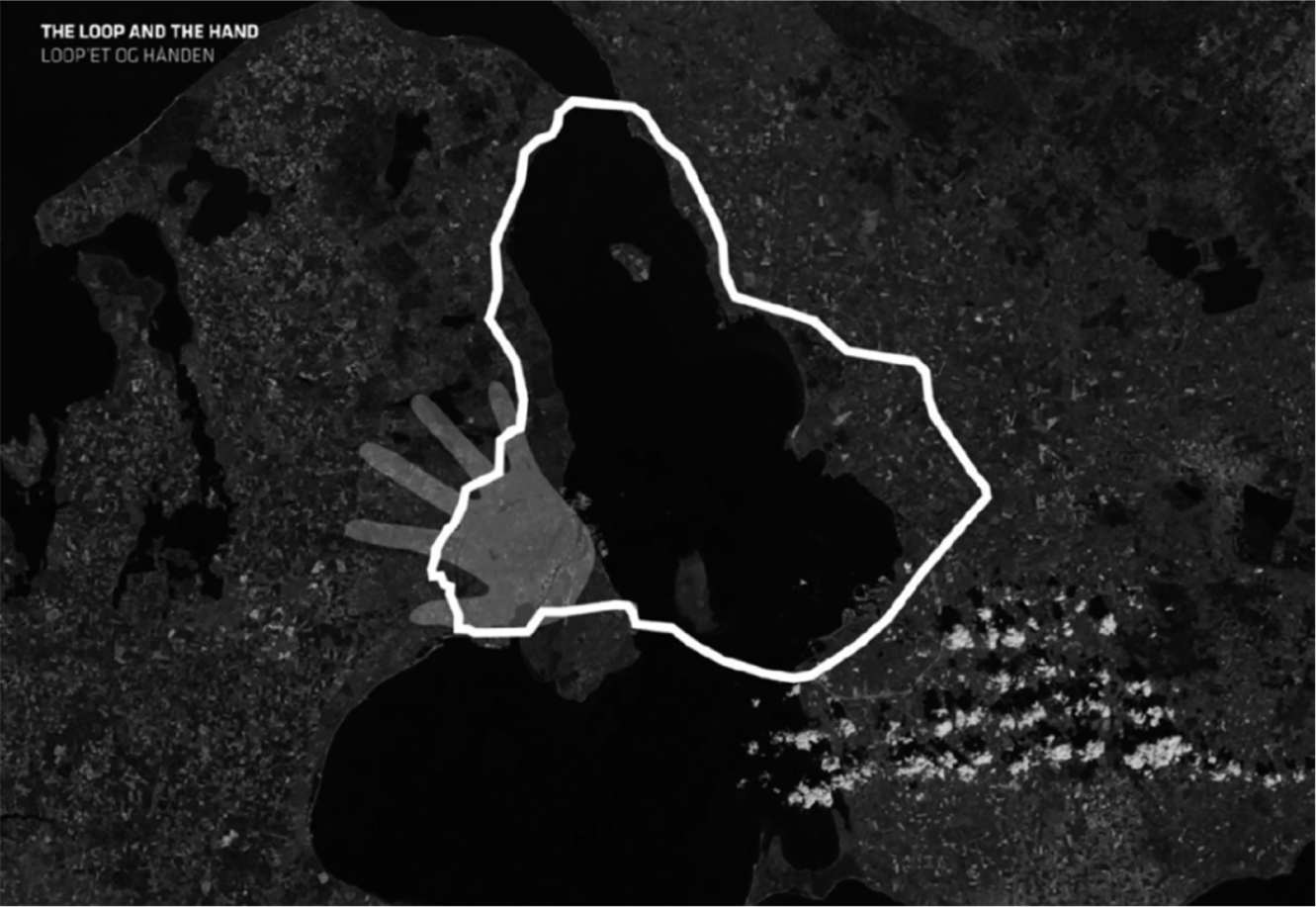
The Loop City spatial imaginary of an integrated public transport loop around the Øresund strait challenging the long-standing Finger Plan spatial imaginary of Copenhagen metropolitan region.
As a means of planning communication, storytelling has a capacity to communicate across different ‘social worlds’ (Star and Griesemer, 1989). Storylines and their metaphors and imaginaries are meaning-making devices, which can ‘create an intersubjective sense of shared meaning’ (Bowman, 2016: 81), and thus they have the potential to shape and frame meaning and action (Healey, 2007; Humphreys et al., 2011). The boundary-crossing virtue of storytelling is its familiarity, with its use of everyday language and multiple forms of representation. The familiarity of a story is also its means of simplification: ‘Just as a sensible event resembles one we have seen before, then a good story is one that we have either heard before or that echoes or resonates with one we have heard before’ (Colville et al., 2011: 8).
Spatial stories, according to Harris (2016), ‘combat the chaos of data overload by providing organizing themes that collate a complex flow of events and places into a meaningful form that can be communicated to others’ (p. 323). Accordingly, metaphors, often presented as one word or phrase, and the imagery of spatial imaginaries, frame planning problems and reduce complexity by simplification (Kunzmann, 1996; Van Duinen, 2013; Zonneveld, 2000). 3 Their persuasiveness and communicative capacity are based on their impreciseness and flexibility. In their simplified and selective description of the city (across time and space), metaphors and imaginaries afford many readings and meanings (e.g. Davoudi et al., 2018; Hincks et al., 2017; Lauerman, 2016; Throgmorton, 1996). Furthermore, they may interlink adversarial interest groups by enabling arguments for different political views and interests, while providing a ‘lightening conductor’ for joining-up, coalition building, agenda-setting and discourse (re)production (Boudreau, 2007; Davoudi et al., 2018; Vigar et al., 2005; Wetzstein, 2013).
In other words, due to their vagueness and simplicity, stories, metaphors and imaginaries provide a stepping stone towards a form of ‘settlement’ or shared reasoning. The more meanings stories, metaphors and imaginaries accumulate, the more support they attract, unless these meanings are contradictory (Van Duinen, 2013). On the contrary, because they do not have fixed meanings (Davoudi et al., 2018; Vigar et al., 2005), their new situational readings may create mutually discordant interpretations, leading to failures in policy coordination (Van Duinen, 2013).
In their selectiveness in representing reality, imaginaries and metaphors are deeply political (e.g. Jonas, 2014), and their flexibility has been used to depoliticize spatial planning (Olesen, 2014a; Swyngedouw, 2010). According to Davoudi et al. (2018), ‘their role in power struggles over places and spaces is masked in the processes of de-politicisation, in which dominant imaginaries are essentialized and naturalized’. (p. 98) Indeed, in shaping attention, the imaginaries portray certain investments and development projects as ‘sensible’ and ‘necessary’, while others fall outside their ‘imagination’ (Lauerman, 2016; Throgmorton, 2003).
Metaphors and spatial imaginaries as boundary objects
As discussed above, persuasive storytelling in strategic spatial planning utilizes metaphors and spatial imaginaries. We suggest that the coordinative capacity of metaphors and spatial imaginaries depends on their performativity as, or operationalization in the form of, boundary objects (cf. Carlile, 2002: 24; Engels and Münch, 2015; Marjanovic, 2016: 5037).
The concept of ‘boundary object’ was coined by Star and Griesemer (1989), in the field of social studies of science and technology, to explain boundary-crossing capacities of coordinated action in local contexts involving actors from different ‘social worlds’. According to Star and Griesemer (1989), boundary objects are both plastic enough to adapt to local needs and the constraints of the several parties employing them, yet robust enough to maintain a common identity across sites. [. . .] They have different meanings in different social worlds but their structure is common enough to more than one world to make them recognizable, a means of translation. (p. 393)
In boundary objects, the inter-conceptual flexibility of interpretation is combined with the robustness of artefactuality. Star and Griesemer (1989) identified the use of several boundary objects in their ground-breaking study of the establishment and early development (1907–1939) of Berkeley Museum of Vertebrate Zoology, University of California. These included repositories, filing systems, geographical boundaries and fill-in forms. They were efficient as boundary-crossing objects and tools between the different actors involved (researchers, trappers, nature enthusiasts, university administrators and the private sponsor) not only because of their conceptual flexibility to different interpretations but also because of their artefactual robustness and attachment to the actors’ varying socio-material activities with differing goals. By being conceptually flexible, boundary objects invite different interpretations. However, at the same time, by being ‘artefactually anchored’, as shared objects of the different socio-material activities, they enable joint coordination of these activities, in the sense of aligning them so that they are mutually supportive.
According to Star (2010), ‘[b]oundary objects are a sort of arrangement that allow different groups to work together without consensus’ (p. 602). Similarly Galison (2010), in describing trading zones, a concept closely related to the concept of boundary object, 4 argues that they focus ‘on coordinated, local actions, enabled by the thinness of interpretation rather than the thickness of consensus’ (p. 37, italics in the original). This has inspired planning theorists to view boundary objects and trading zones as situated tools and platforms that would enable relaxation on the consensus approach to communicative planning, focusing instead on the context-specific and issue-based conditions for the stakeholders’ joint coordination, despite the dissensus regarding their deep-seated values and goals (Fuller, 2006; Mäntysalo et al., 2011; Mäntysalo and Jarenko, 2014). In Star and Griesemer’s case study, the boundary objects enabled the co-alignment of different socio-material practices of different actors with differing goals. There was no need, for example, for the trappers to share, or even grasp, the goals of those of the researchers or university administrators. Still, by using shared boundary objects, they became coordinated, so that each could pursue their own goals in a manner that benefitted also others. Although the actors did not have shared goals, they were dependent on each other’s activities in pursuing their own goals. Managing such contentious interdependence is what characterizes planning to an increasing degree (Forester, 1999). Indeed, in such conditions of actors being mutually interdependent in the pursuit of their own goals, yet lacking mutual consensus and even deeper comprehension of each other’s goals, the coordinative capacity brought by boundary objects becomes highly valuable. Here, coordination is understood in the sense of co-alignment of actors, so that they may benefit from each other’s actions, despite not necessarily sharing each other’s goals.
Some studies in different fields have drawn on the concept of boundary object and its connections to storytelling and imaginaries. For example, Bowman (2016) argues that products of storytelling may offer a ‘mechanism, in the form of a meaningful artefact that can help transfer knowledge through complex, pragmatic boundaries’ (p. 83). In turn, by connecting the concepts of imaginary and boundary object, Engels and Münch (2015) argue, in their case study of an urban innovation campus in Germany, that the transformative success of the studied imaginary resulted from its coordinative performativity as a boundary object.
The aspect of artefactual anchoring has a crucial role in the coordinative capacity of boundary objects. With artefactual anchoring, we do not necessarily refer to concrete physical objects (see Carlile, 2002: 452). It is the nature of the planning problem at hand that determines the appropriate concreteness of a given boundary object. At a certain stage of strategic spatial planning, a certain spatial vision may appear as sufficiently concrete to gain coordinative momentum, while at some later stage, it may appear as uselessly abstract and vague. As boundary objects, artefacts are ‘externalized’ inter-cultural objects (see Hauser, 2017; Miettinen et al., 2012). They coordinate action by performing as triggers, such as environmental cues, that prompt responses, and/or placeholders, such as planning documents, that instruct what to do (Susi, 2005). Artefacts have different functions: on one hand, they may be objectified as targets of coordinated efforts; on the other hand, they may provide material or discursive tools and means for coordinated action. It is the arrangement of the activities at hand that determines the use of the artefact (Kangasoja, 2017).
In relation to strategic spatial planning, previous literature has mostly emphasized the inter-conceptual, communicative capacity of spatial imaginaries and metaphors (e.g. Hincks et al., 2017; Vigar et al., 2005). However, some previous studies have acknowledged their coordinative capacity at the inter-actional level, too (Baker and Ruming, 2015; Jensen, 2007; Wetzstein, 2013). For example, in the Australian context, Wetzstein (2013) shows how imaginaries have resulted in key events, programmes and investments in physical infrastructure. Furthermore, Baker and Ruming (2015) describe how a strategic plan and infrastructure planning became the anchoring points of the Global Sydney imaginary. On the other hand, in the Dutch context, Van Eeten and Roe (2000) argue that the regional imaginary of the Green Heart has sustained a strong, normative and spatially anchored role, despite the contestation of its ‘real’ existence.
In a case study of strategic spatial planning in the city of Kuopio, Finland, Mäntysalo and Kanninen (2013) have analysed the conception and implementation of the so-called Kuopio Model, a spatial imaginary (and a related ‘transport city’ key metaphor) portraying the city as a system of overlapping fabrics of the ‘walking city’, ‘transit city’ and ‘car city’ (Figure 2). The study highlights the role of the artefactual level of this spatial imaginary, brought by the coordinative capacity of boundary objects that have operationalized the Kuopio Model, especially between the land use and transport planning sectors.
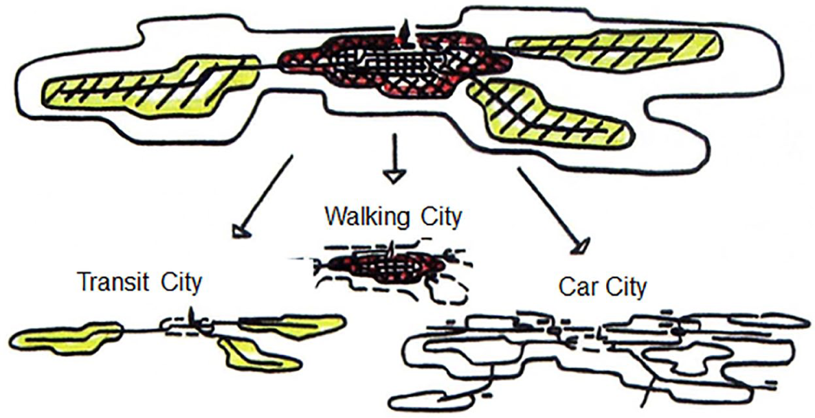
The Kuopio Model: a spatial imaginary of the urban system and a basic boundary object, unfolding into further boundary objects (physical, data, plan and model artefacts) in the course of inter-sectoral planning work in Kuopio.
The Kuopio case exemplifies the importance of artefactual anchoring via boundary objects for the success of a spatial imaginary. It provides triggers and placeholders for bringing the different activities together (e.g. planning and design models, statistical survey categories, key environmental objects) while being conceptually plastic enough to afford multiple interpretations. Such coordinative capacity would be lost, if the spatial imaginary were too abstract, fuzzy or ‘fluid’, lacking the level of shared artefactual objects. This could be the case especially when fluid spatial imaginaries and associated fuzzy cartographic presentations and relational metaphors are purposively used to establish political consent and depoliticize planning processes (Davoudi and Strange, 2009; Jensen and Richardson, 2004; Olesen and Richardson, 2011). Another risk is that they are purposively (re-)designed or continuously watered down in political discourses to avoid or camouflage conflicts (Van Duinen, 2015).
An illustrative example of such dysfunctionality of a spatial imaginary is presented by Granqvist et al. (2019) in a case study of the City Plan of Helsinki, Finland. In the Helsinki metropolitan region, the spatial imaginary of polycentricity had been used as a vague, politically pacifying concept among the local, city-regional and regional governance organs, each of which had different meanings given to polycentricity in terms of scale of reference, the status of centres vis-à-vis each other and the transport system interconnecting them. Here, the imaginary did not provide coordinative capacity, as the artefactual level with associated boundary objects was missing.
In the discussion above, we suggest that the performativity of a spatial imaginary, or metaphor, as a (set of) boundary object(s) is crucial for the coordinative capacity of strategic spatial planning as persuasive storytelling. In particular, we are interested in coordinative capacity generated between different (government and non-government) actors, not necessarily due to institutionalized forms of collaboration or coalition building, but simply due to co-alignment of activities. It is in exploration of this particular form of coordinative capacity that we see the concept of boundary object to provide a helpful analytical lens.
In addition, we suggest that it may not be sufficient for storytelling and associated spatial imaginaries and metaphors to be conceptually flexible to provide coordinative capacity. There is also a need for their artefactual anchoring. How it might be achieved is highly context-dependent. It may be achieved through implementation of new transport infrastructures, for example, but the anchor does not necessarily have to have such an explicit material expression, as in the case of Aalborg growth axis.
In the next section, we provide an example of strategic spatial planning as persuasive storytelling in the city of Aalborg. We demonstrate how the spatial imaginary of the ‘growth axis’, and metaphors related to it, is made artefactual in the city, anchoring the city’s strategy in the form of boundary objects and thus generating coordinative capacity.
The Aalborg growth axis
Since the beginning of the 1990s, the city of Aalborg has, as many other European cities, been in a transformation process, adjusting to the decline in the primary industries and the rise of the knowledge economy. In Aalborg, this process has been promoted by the municipality through the persuasive story of the city transforming from an industrial to a knowledge and culture city (Andersen, 2013; Jensen, 2007). This transformation has been quite visible in the city, most notably in the regeneration of the harbour front (still ongoing) and a number of architectural flagship projects hosting cultural institutions, such as the House of Music and the Utzon Centre (Andersen, 2013; Galland and Hansen, 2012; Jensen, 2007). In addition, the urban transformation has been guided by an urban branding agenda, focusing on changing the image of the city and attracting what Florida (2002) has coined ‘the creative class’ (see Jensen, 2007). In its initial redevelopment phase, the transformation of the city was rather entrepreneurial, relying on attractive lighthouse projects without an overall framing vision (Andersen, 2013). By the end of the first decade of the new millennium, this was to change.
Entering strategic framing: ‘the growth axis’
The arrival of a new city architect in Aalborg coincided with a new approach to strategic spatial planning in the municipality. The need for a more strategic approach to municipal planning in Denmark had been debated in planning circles since the 1990s, and in the 2000s, it became obligatory for municipalities to prepare a strategic plan. Part of the motivation for strengthening spatial planning’s strategic dimension was to increase the politicians’ interest in spatial planning (Grange, 2014; Scharff, 2018). In Aalborg, this agenda became an integrated part of preparing the strategic plan 2011, titled North Denmark’s Growth Dynamo (Aalborg Municipality, 2011). Reflecting on the 2011 strategic plan, the city architect explains, The strategic plan 2011 has since set the agenda for the development. The clear political goals explained briefly and clearly (approximately 40 pages)
5
meant a revitalisation of the political debate and the political ownership. Planning entered, so to speak, the political agenda – again. (Nielsen, 2014: 11, authors’ translation)
A crucial part of bringing spatial planning back to the political agenda was the development of a shared frame of reference, a commonly accepted strategic frame. The metaphor of the ‘growth axis’ emerged with an amoeba-shaped spatial imaginary across the city, providing some structure and logic to the otherwise somewhat scattered urban development projects that had already been decided upon or constructed (Figure 3). In the 2011 strategic plan, the growth axis imaginary was introduced as the main area for urban development and municipal investments in infrastructure (Aalborg Municipality, 2011). In the strategy, the growth axis is further metaphorically referred to as ‘the dynamo’, ‘the spine’ and ‘the driving force’ for growth in the entire region of North Denmark (Aalborg Municipality, 2011: 5). It is perhaps best understood as partly a description of ‘what reality looks like’, and partly a strategic prescription to channel public and private investments into particular urban redevelopment sites in the city, with the aim of supporting economic growth in Aalborg and the surrounding region (Olesen, 2020).
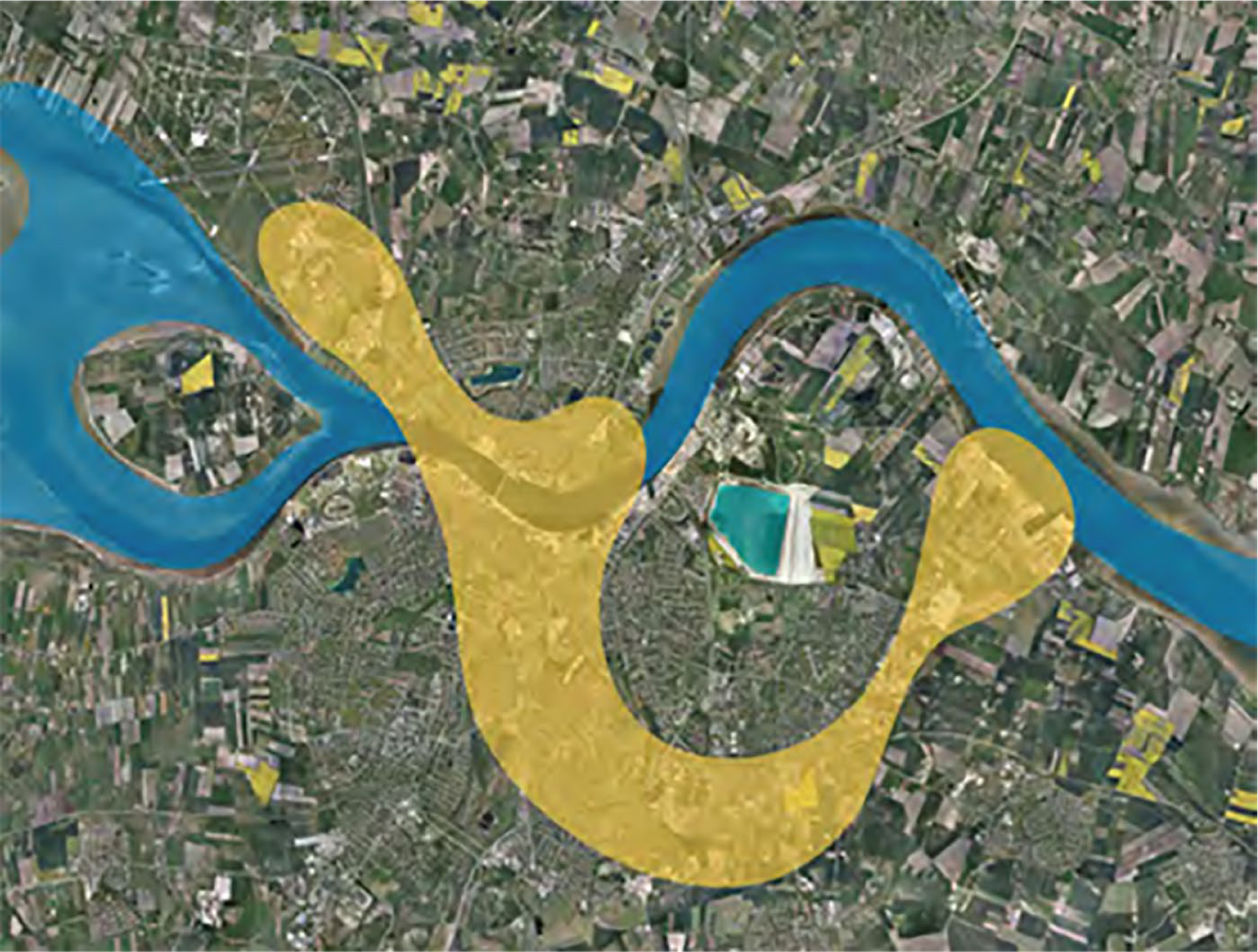
The growth axis connects the airport in the north-western part of the city, the city centre, the university campus and hospital in the south, and the port in the east.
The 2011 strategic plan recognizes that the growth axis is more about constituting a brand for urban development than clearly defining an urban development area: The growth axis does not have sharp geographical boundaries like a traditional urban development area. It is rather an area, which is created by the development and the projects that exist. A name or perhaps rather a brand for the development and the great potential there is in Aalborg. (Aalborg Municipality, 2011: 8, authors’ translation)
Nevertheless, as a metaphor and spatial imaginary, the growth axis has been important for mobilizing attention to the urban transformation of Aalborg, and as a structuring principle of spatial planning in facilitating this development. In addition, the concept of ‘growth’ resonates well with the imaginary of the city, to which the city council and private investors easily can subscribe. Scharff (2018) notes how the imaginary of the growth axis already was on the retina of the politicians and developers in Aalborg before the strategy was published. In essence, the spatial imaginary conveys a very simple message to both politicians and private investors: ‘Invest here, please!’
What has been another important aspect of the strategy is communicating the growth axis to key actors in the city and to the general public as a common spatial imaginary of the city. This ambition is clearly stated in the 2011 strategic plan: It is a clear goal that the planning strategy is not only the city council’s, but the entire municipality’s. The goal is that the businesses, developers, entrepreneurs, planners and not least the citizens develop co-ownership of the strategy, so everybody knows what to expect in the years to come. (Aalborg Municipality, 2011: 7, authors’ translation)
The ambition has also been that the strategic plan, and associated spatial imaginary, is anchored not only in the planning administration but also across the different administrations of Aalborg Municipality (Nielsen, 2014). As the city architect elaborates, The corporate body of Aalborg Municipality could use the strategic plan’s clear visions and goals to formulate an entirety for all sectors’ goals and visions. Given that spatial planning abstained from formulating ‘a plan one has to follow’, but instead set up a common image of where the municipality is moving, the understanding was created that the municipal plan could be a common instrument, which partly still is ‘authority’ for the spatial (local plans and building permit applications), but which also can be used in the corporate body’s need for a common strategy and vision of the municipality’s development. (Nielsen, 2014: 12, authors’ translation)
The spatial imaginary’s clear, concise and simple message has been important for gaining political support and revitalizing political interest in spatial planning in Aalborg. Furthermore, the imaginary of the growth axis has almost become synonymous with the urban transformation of Aalborg, as it provides a spatial logic to the many redevelopment projects in the city. In addition, the growth axis features as a brand or logo in several municipal policy documents, booklets and posters, and has in this sense developed into a unifying spatial imaginary for the entire municipal administration. At an inter-conceptual level, the imaginary and metaphor of the growth axis seems to be sufficiently strong to mobilize the attention of politicians, developers and various municipal administrations within its frame, while allowing space for various interpretations of the growth axis, for example, in terms of its geographical boundaries. However, gaining coordinative capacity between the actors, in mobilizing their attention, would require the attributes of boundary object and related artefactual anchoring to be found in the growth axis imaginary and metaphor. We will turn to this issue in the next sub-sections.
Artefactual anchoring: the light rail transit/bus rapid transit spine
Even before the conception of the growth axis, the dream of having a light rail transit (LRT) system was on the political agenda in Aalborg, as implementation of LRT schemes was discussed and planned in other major Danish cities (Nicolaisen et al., 2017). In the 2011 strategic plan, the light rail project was reframed in the context of growth axis and thereby given renewed political importance: The ambition of the light rail is an important piece. The city council is working intensively to investigate this possibility. Aalborg does not at present have the size and thereby the passenger volume, which is needed to support this mode of transport. But if we concentrate growth in the growth axis, the necessary ‘critical mass’ can be created. (Aalborg Municipality, 2011: 13, authors’ translation)
As the quote above suggests, the municipality’s spatial strategy of the growth axis might serve the dual purpose of concentrating urban development in the desired areas of the city, while providing the passenger base needed for the light rail to become a socio-economically feasible investment. In the municipality’s spatial vision 2025, published in 2013, the growth axis and the light rail project are integrated further. The spatial imaginary of the growth axis presented here is metaphorically referred to as ‘the city’s engine’ (Aalborg Municipality, 2013: 10), and the light rail is argued to constitute ‘the spine of the growth axis’ (Aalborg Municipality, 2013: 11). In this way, the light rail project provides a clear infrastructural anchor for the otherwise somewhat loosely defined growth axis. In this spatial imaginary, the light rail project gains significance as the very artefactualization of the growth axis – bringing the growth axis into life. In this way, the light rail project – and not least the proposed routing of the light rail line along the growth axis from the western part of the city, via the city centre to the university campus in the east – develops an artefactual status in the municipality’s spatial planning and the region’s transportation administrations (Figure 4) (Popescu, 2016).
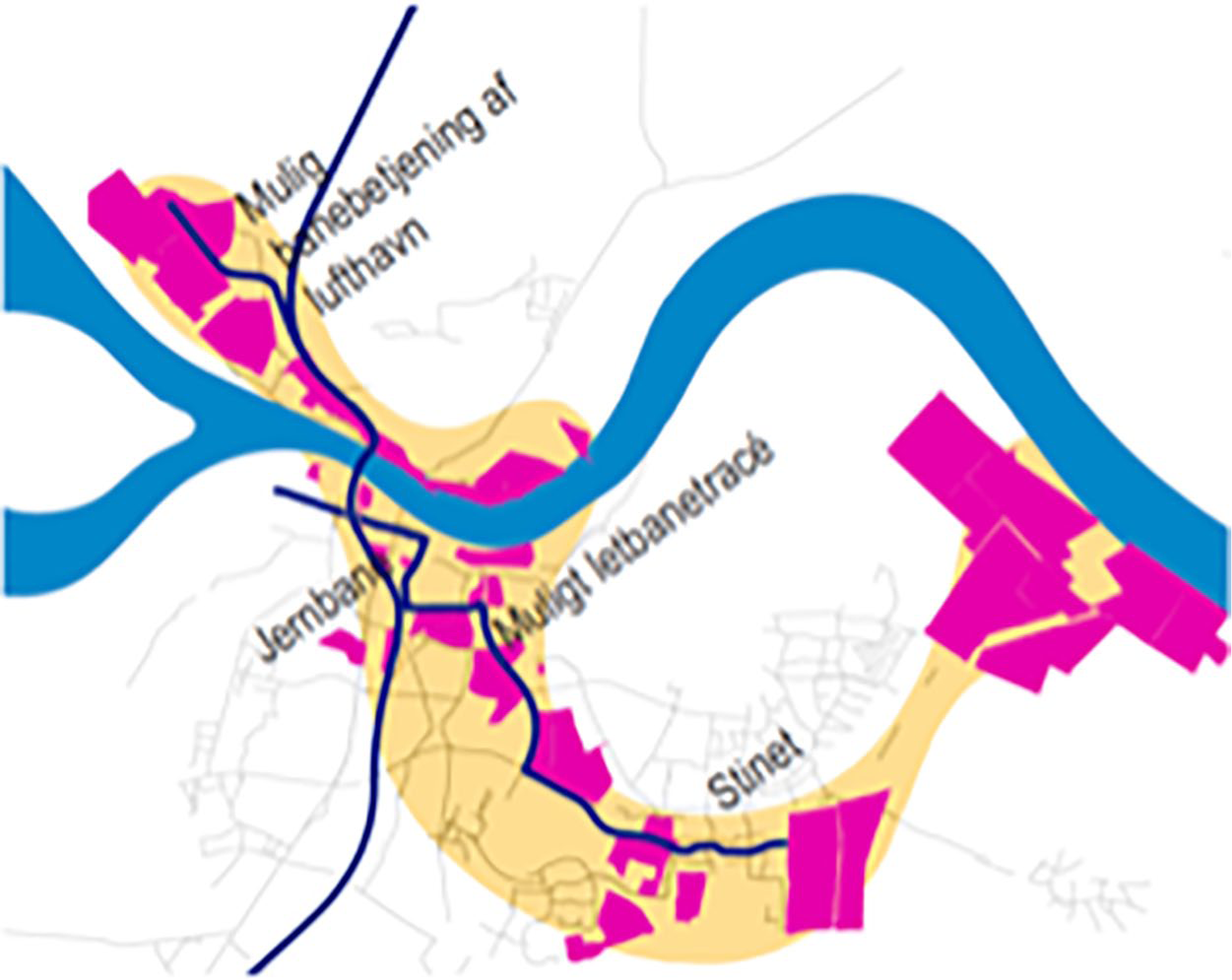
The LRT/BRT line along the growth axis in connection to the north–south rail line, with major development sites depicted.
While the growth axis has played an important role in gaining political support and revitalizing political interest in spatial planning in Aalborg, the light rail project provided the artefactual anchoring needed to maintain the commitment and support for the urban transformation project. Furthermore, the light rail project played an important role in providing a sense of determination and certainty for developers seeking to invest in the growth axis (Olesen, 2020).
In 2015, the newly elected liberal-conservative national government withdrew the previously agreed government funding for the LRT scheme in Aalborg, and as a consequence, the light rail project was put on hold. In the municipality’s most recent strategic plan from 2016, the LRT system has been replaced by a bus rapid transit (BRT) system, following the same routing along the growth axis, and thus resuming the promotion of the overall agenda of urban transformation (Aalborg Municipality, 2016a; Olesen, 2019). In 2017, with the support of the opposition parties, the national government granted a funding of 250M DKK (50% of the estimated total costs) to the BRT system in Aalborg (Kidmose and Kristensen, 2018).
In the municipal policy documents from 2016 and onwards, considerable energy has been put into incorporating the BRT scheme into the spatial imaginary of the growth axis and the overarching story of Aalborg in urban transformation (Kidmose and Kristensen, 2018). In a booklet promoting the BRT scheme, the municipality articulates the BRT scheme, labelled ‘+BUS’, as the ‘the city’s new life nerve’ (Aalborg Municipality, 2016b: 1). The municipality’s plans are ambitious in their designs of the streetscape along the BRT line and urban spaces around the ‘BRT stations’, in order to maintain, as much as possible, the qualities associated with the light rail and its properties as catalyst for urban development (Kidmose and Kristensen, 2018). In this way, despite a (significant) replacement of transport technology, the municipality has managed to maintain the developers’ and real estate investors’ interest in sites along the growth axis. Due to the municipality’s revived storytelling, the artefactual anchoring of the growth axis has been maintained.
Boundary object and coordinative capacity
We now return to the properties of the growth axis as a boundary object and its coordinative capacity. As discussed above, the simple and easily conceivable imaginary of the growth axis, and the related metaphors, has played an important role in gaining political support for strategic spatial planning in Aalborg, as well as in providing a shared frame of reference across the municipality’s administrations. In addition, the LRT/BRT scheme has provided the growth axis with a ‘spine’ in the sense of artefactual anchoring of the growth axis and has been important for maintaining the support for the growth axis strategy over time. At the same time, the growth axis has provided a clearer sense of strategy for the urban transformation of Aalborg, uniting seemingly fragmented urban development projects into a meaningful scheme.
The clear message of the growth axis has also resonated with the aims of some of the main developers in the city. By clearly communicating where the municipality intends to invest in the city, for example, in terms of transport infrastructure, the private investments seem to have followed suit. Scharff (2018) notices that it appears as if the municipality and the private developers were ‘clapping in sync’ (p. 54). This suggests that the growth axis also plays a coordinative role at the inter-actional level. An example is one of the main non-profit housing developers in the city, which adopted the growth axis as the spatial reference frame for its new housing programme, launched in 2015, and used it as a point of departure for its negotiations with the municipality (Figure 5). In this way, the growth axis has developed into a shared imaginary that developers have to adapt their projects to in order to get their development projects approved. Another example is the Port of Aalborg (2017), which in its corporate social responsibility strategy presents itself as a catalyst for growth in Aalborg and the North Denmark Region, by making a reference to its location within the growth axis. In this way, the growth axis seems to perform a coordinative role, very much in the sense of a boundary object.
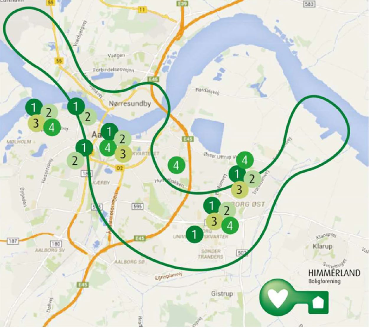
A map in the local non-profit housing developer’s housing programme, depicting its housing development proposals in relation to the growth axis. The sites of proposed development do not fully match with the growth axis, and the developer has stretched the boundary of the growth axis to display it as better fitting with its sites of new development. In the interview, the City Architect claimed that this is not a problem for the municipality, as the developers’ sites of interest match well enough with the area of the growth axis, and as the growth axis delineation in the plan is not meant to serve as a regulative zoning tool.
In this regard, the findings so far are not yet clear on the importance of artefactual anchoring with the BRT line. Kidmose and Kristensen (2018) observe that the artefactuality of the BRT line seems to be more important for housing associations than for private developers, as residents in housing associations tend to be the primary user group of public transport (at least bus solutions). On the contrary, it is indeed this artefactual anchoring that the municipality is seeking to strengthen by relying as much as possible on the LRT-lingo in their storytelling of the +BUS (Kidmose and Kristensen, 2018).
Concluding remarks and discussion
In strategic spatial planning, persuasive storytelling, equipped with spatial imaginaries and metaphors, plays an important role in mobilizing attention of different actors. By affording many interpretations, such storytelling invites engagement. However, interpretative flexibility may also become its greatest weakness: the multiple interpretations may be revealed to be mutually discordant, when attempting at identifying joint spatial planning targets and tools.
The hypothesis that we have sought to develop in this article is that persuasive storytelling and associated spatial imaginaries and metaphors have to be not only conceptually flexible, but also artefactually anchored, in order to build the needed coordinative capacity for interaction in accordance with the strategic frame. This means that with the unfolding of the strategic plan, sufficiently robust intercultural artefacts have to be identified and generated as tools and targets for the joint coordination of the stakeholders involved. In order to perform as coordinative media at the ‘inter-actional’ level, beyond being broadly communicative at the ‘inter-conceptual’ level, the metaphors and spatial imaginaries have to reach the performativity of boundary object. This performativity provides artefactual anchoring for the actors’ co-alignment.
Our preliminary observations of strategic spatial planning in Aalborg suggest such performativity, but further evidence is needed. Indeed, our intention is not to make definitive empirical claims of the Aalborg case itself, as further case research is needed. Instead, through our tentative reflections on the empirical example, we have aimed to show the feasibility and relevance of our theoretical approach for future case studies, interested in examining the coordinative capacity of strategic spatial planning as persuasive storytelling.
For the research design of such a case study, the point of departure would be the identification of the storylines, metaphors and spatial imaginaries, produced by the studied city government or other public body in charge of developing a spatial strategy. It would be conducted by analysing the related policy and planning documents and the interviews made. The next step would be the identification of the other actors that are thereby addressed: Who are being persuaded with persuasive storytelling and whose imagination is invited with the related spatial imaginaries and metaphors? Can boundary-crossing qualities be identified in how the storylines, metaphors and imaginaries are constructed and designed? How, then, do the actors addressed respond to such persuasion? Can they be found to resonate or reproduce the storylines, metaphors and imaginaries in their own documentation and interview accounts? If so, what kind of interaction is there between the public body and these other actors, related to the spatial strategy? How do they characterize this interaction in the interviews? If they report mutual coordinatedness, do the decisions and plans by each, and development ‘on the ground’, identified by field study, support such claims? If the answer is yes, how, then, could this coordinatedness be understood and explained?
The case study would then turn to examining closer the qualities of this coordination. Besides document and interview analysis, such an inquiry would benefit from an ethnographic or participatory observation approach, by observing the actual interaction between the actors in joint meetings and other events. What kind of (sets of) ‘work arrangements’ (Star, 2010: 604) are generated? Can the metaphors and spatial imaginaries (re)produced be identified to perform as joint tools and targets in these arrangements? How do they perform as such? Do they provide shared, yet differentiable, objects to the different actors involved? Do these objects indicate spatial fixes acknowledged by the actors, in the sense of artefactual anchoring? Are there thus boundary objects in place? Are they the key to how the coordinative capacity in strategic spatial planning can be understood and explained, in the studied case of strategic spatial planning as persuasive storytelling?
The identification of the actors involved and the means of their involvement may well beget a further inquiry regarding the political dimension of coordination enabled by the boundary objects of strategic spatial planning. How do the boundary objects enable engagement of the actors addressed, both inter-conceptually and inter-actionally? Which boundaries are they designed to cross, and which not – and who are thus excluded?
This latter set of questions brings us to critical reflections on the political and power implications of boundary objects. The example of strategic spatial planning in Aalborg clearly demonstrates how the municipality, developers, investors and other resourceful actors form a growth coalition (see Molotch, 1976) around the city’s growth axis strategy. In this reading, the boundary object of the growth axis contributes in fostering this growth coalition, centred on the narrow political agenda of economic growth. Accordingly, the LRT/BRT project can be seen to represent a travelling idea (Olesen, 2014b; Tait and Jensen, 2007), promoted with the aim of boosting Aalborg’s image and self-esteem as a competitive and foresighted city. The growth axis and the related LRT/BRT project can, in this vein, be understood as expressions of neoliberal storytelling characterizing strategic spatial planning in Aalborg. Indeed, following this line of inquiry, Olesen (2020) has recently made critical observations on the power implications of the Aalborg growth axis strategy. In this sense, Olesen’s article is complementary to ours.
We thus argue that there is a need for incorporating a critical perspective into the analysis of spatial imaginaries and metaphors and their possible performativity as boundary objects. As Olesen (2017) has demonstrated in the case of the Loop City, strategic spatial planning as persuasive storytelling can play important roles in supporting the ongoing neoliberalization of strategic spatial planning (Olesen, 2014a) and in promoting transport infrastructure projects as solutions to urban problems (Dodson, 2009; Olesen, 2020).
Our primary interest in this article has been to hypothesize how strategic spatial planning as persuasive storytelling can gain coordinative capacity. With this choice of focus, our intention has not been to undermine the importance of further research questions regarding the political dimension involved: who are and who are not to be coordinated with the ‘work arrangements’ identified, what for and with what justification? Gaining insights on how the mechanisms of coordination operate increases also our ability to understand how these mechanisms contribute to the selection of the actors to be involved in this coordination.
Footnotes
Funding
The author(s) disclosed receipt of the following financial support for the research, authorship, and/or publication of this article: This work was supported by Academy of Finland [Grant Numbers 303538 and 288848].