
Abstract
This article uses the resolutional relationship between digital image and planetary surface in satellite remote sensing as a lens through which to view the reliance of visual culture on mineral resources. While most studies of resolution in satellite imaging have focused on visibility and invisibility, the author argues that the equivalence between pictorial and geographic space in its cm/pixel specification offers an opportunity to consider the physical relationship between the two. The proposed inversion enables the satellite and its transmitted images to be understood as contingent upon an unsustainably extractive industrial model. The article then traces the material trajectory in geophysical prospecting applications of remote sensing, identifying a recursive loop in which images are used to produce minerals that are used to produce images. The potential geopolitical impact of this circularity is then assessed with regard to an example of future remote sensing emissions governance.
In this, and many other climate-critical applications, remote sensing potentially plays a vital role, yet its instrumental gaze tends to shape the earth as an informational resource whose mineral reserves should be capitalized upon. Ultimately, the author’s aim is not to denounce earth observation as ecologically untenable, but to propose that we find a measure with which to assess the planetary impact of the various aspects of industrialized visual culture. Conceiving of resolution not as a measure of pictorial space but of the terrestrial cost of producing, consuming, distributing and permanently storing digital images might enable a more relational understanding of image and ground, pixels and planet. Accounting for the inverse resolution of an image could bring the deep temporal costs of digital visual culture into focus.
Gazing down on northern Europe at a resolution of 1 km/pixel, 60 kms to the west of Hamburg lies the Rotschlammdeponie, a dark red square, a single pixel of almost pure colour in a matrix of variegated greens that we instinctively interpret as a rural, arable landscape (see Figure 1). If this lake of red mud is only 1 m deep then it would contain approximately 1 million tonnes of Bauxite waste, the discarded by-product of Aluminium Oxide refinement at AOS Stade 10 kms to the east. Gazing down at the Google maps satellite image of this region, reproduced on my laptop screen at a resolution of 4,096,000 pixels, I see a landscape transformed from environment to image, a process of visualization that Lisa Parks (Parks and Walker, 2020: 8) has referred to as ‘digital approximations of remote realities’. Species of foliage are enumerated into various chromatic hex codes of green, homes are folded into its gridded grain. The laptop screen on which I watch this locality become an image is encased in ‘space-grey’ brushed aluminium, which was once refined from Bauxite.
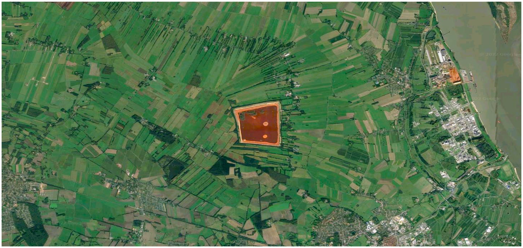
Google satellite image of the Rotschlammdeponie in Northern Germany.
Resolution is commonly understood in photography as having a singular meaning: the dimensions or area of a digital image. It is measured in pixels. Resolution tends to be exclusively thought of as a spatial quality of the image and the recent technical history of photography is dominated by a progression of resolutional standards: from SD to HD, from 6 to 16 megapixels, from 2k to 4k to 8k. In satellite and airborne imaging, resolution is measured in cms, ms or kms per pixel, and so becomes not only a definition of the size of the image itself but also of its equivalence with the territory it represents. This relationship between aerial image and planetary surface has been theorized almost exclusively from the position of visibility and invisibility: what is captured and what is occluded by resolution. Hito Steyerl’s now canonical video How Not to Be Seen (2013) has been key in enshrining this understanding, at least among contemporary art audiences. And Eyal Weizman (2017: 30) describes the cm/pixel measurement that scales real space to pictorial space as ‘the threshold of detectability’, a dimension beneath which all subjects and objects disappear, averaged out from the photon flux of a single pixel. Resolution, from this perspective, is akin to a sieve in which grains of a certain size are held, while others – most notably for Weizman, human beings – pass through undetected and invisible. The active capacity foregrounded by this conception of resolution is the satellite’s ability to make things appear or disappear in its visualizations. But the satellite also acts directly on the ground in two ways: perceptually and physically.
I will concentrate here almost exclusively on the physical relationship between Earth and Earth observation. However, before doing so, I will briefly address its perceptual effects. In one view, the dislocation of embodied perception offered by the vertical gaze upon the planetary surface increases humanity’s false sense of superiority and reinforces our dissociation from a biosphere upon which we are wholly reliant. For TJ Demos (2017: 28), for example, aerial imaging ‘plays more than an illustrative role’, conferring ‘a sense of control over the represented object’ and tending to ‘reinforce the techno-utopian position that we have indeed mastered nature, just as we have mastered its imaging’. If Demos’s opinion holds, then the deep irony is that this perceptual effect runs completely counter to the epistemological lessons drawn by climate scientists from the same data: the very tool that we use to assess the catastrophic ecological impact of current industrial practices tends to perceptually defer a sense of mastery merely by its perspective.
In framing the discussion of the physical effects of earth observation that follows, I would like to pick up on Sverker Sörlin and Nina Wormbs’ (2018) concept of environing technologies, of which they offer the satellite as one example. Sörlin and Wormbs define environing as ‘the process through which humankind impacts nature to form environment’ (p. 3). They articulate three distinct but entangled types of environing: sensing, writing and shaping, which they describe as being more often interconnected than distinct. Since the 1980s, the applications proposed for satellite remote sensing have mainly been various forms of resource management – be they agricultural, infrastructural, mineral, or atmospheric. The European Space Agency’s Sentinel-2 User Handbook (2015), for example, lists land monitoring as its primary application stating that it ‘supports a variety of applications including spatial planning, forest management, water management, and food security’ (p. 39). The major applications of satellite remote sensing either directly shape, or inform the shaping of, terrestrial space by industrial and agricultural production. Satellites do not merely sense the environments they monitor but the consequences of their imagery lead to an active environing of landscape.
In what follows, I would like to think of resolution not just as a technical specification but as a physically-shaping environing technology. To do so, I will focus on a singular application of aerial and satellite imagery where it serves as a tool in mineral prospecting, a process Jussi Parikka (2015b: 127) has described as ‘the earth becoming a source and a resource through software visualisations that assist mining and drilling companies, geoscientists and the construction industry’.
Inversion
The thought experiment that I would like to propose is a simple inversion of the cm/pixel measurement of resolution: not how much geographic space is represented by a single pixel, but instead how many pixels can be produced from each square metre of terrestrial resources. Through this inversion I hope to come to an understanding of resolution that might be able to balance both sides of the cm/pixel equation, one which accounts for the planetary space surveyed as well as the instrument of surveyance. In this way, I want to ask quite simple, elementary questions about the ecological impacts of visual culture, questions that – in spite of being largely quantitative – are at present almost incalculable. What are the direct impacts of digital imaging on geographic space? How many square metres of terrestrial surface are cleared, quarried, mined, or polluted for every megapixel of photographic apparatus manufactured? How many pixels can the planet support?
You might argue that in the word footprint we already have a perfectly decent term for describing these sorts of impact. However, the term footprint has become so attached to the notion of a carbon footprint that in common usage it is considered to be a measure of direct emissions generated by a single process, often occluding the indirect emissions produced during manufacture and shipping as well as those generated after obsolescence. Furthermore, as Rebecca Solnit (2021) pointed out in an article for The Guardian, the term carbon footprint was the brainchild of an advertising firm hired by BP to promote the idea that climate change is a matter of personal rather than corporate responsibility. And, in satellite broadcasting, the term footprint has a somewhat different meaning where – as Lisa Parks (2005: 49) writes – it is ‘typically understood as a technical term referring to the geographic boundary in which a given satellite’s signal falls’. The understanding that I am more interested in was recently outlined in an article in Scientific American where the term material footprint was defined as ‘the aggregate quantity of biomass, metal ores, construction minerals and fossil fuels used during production and consumption of a product’ (Dhara and Singh, 2021) and even that definition fails to account for environmental impacts that follow disposal.
The idea of inverting resolution echoes Peter Sloterdijk’s use of ‘inverted astronomy’ to mean ‘looking down from space onto the earth rather than from the ground up into the skies’ (see DeLoughrey, 2014: 257). Here, I follow artist Bethany Rigby who previously picked up on Sloterdijk’s term, using it as the title of a research project that sought to counter what she describes as ‘the removal of satellite imaging from environmental responsibility’ (Rigby, 2017) by connecting satellites to their material beginnings in quarries and mines. By researching the manufacture of a satellite’s components, Rigby made a list of 26 minerals essential to their construction and the sites of their extraction. In her series Mineral // Mine, photographs of mineral samples are paired with magnified satellite images of the mine where they originated, demonstrating a visual correspondence of micro and macro perspectives. More recently, Rigby has assembled a collection of these Satellite Minerals (Figure 2), samples of rock obtained from global mining companies, and laser etched them with the GPS co-ordinates of their origin or diagrams of the satellites they might otherwise have become. Since Sloterdijk’s coinage of inverted astronomy in 1990, the epistemic functions of satellite imagery have expanded considerably and the aerial view is so widely available that today the general public can access and download multispectral images of the entire planet, updated daily.
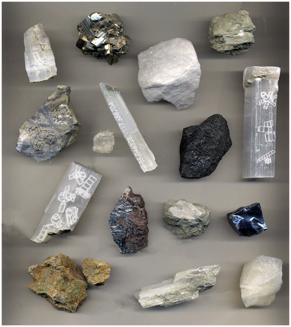
Bethany Rigby – Satellite Minerals (2017).Reproduced courtesy of the artist.
The inversion of resolution I am proposing also inverts the gaze of these satellites so that, instead of perceiving the planet through these orbital technical sensors, we perceive their capacity to sense through the minerals from which they are produced. This aligns with the position that Parikka (2015a) takes in considering media to be extensions of the earth rather than extensions of human perceptual faculties. In thinking resolution from the ground up, rather than from the lens down, we afford primacy not to technology, apparatus and instrumentation but to mineral sands, metallic ores and terrestrial elements, asserting the planet as the sole, finite source from which all that we manufacture must be drawn.
Understanding the vertical perspective from the ground up also inverts the conical space of perspectival vision. Technologized sight becomes not an ever-widening beam of visibility but an ever-narrowing frame of reference: a kind of tunnel vision that sees only instrumentally, perceiving the earth only as raw resources for the production of images. This leads us to the obvious yet pertinent realization that the materials required for the perpetual escalation of photography which we are currently experiencing are far more extensive than the instruments they produce. Another question then: at what height would a satellite have to orbit for its km/pixel image resolution to also be a measure of its resource consumption? While questions like this might appear to be simply a conceptual conceit, my intention is to take their provocation seriously. The production of scientific knowledge, of climate data and of visual culture are all equally implicated in the imperative to reduce their resource consumption. Taking positive steps to achieve such reductions will inevitably require some means of quantitative accounting for priorities to be established and trade-offs understood. Might it be possible for the consumptive scalar relationship between image and ground to become a new understanding of resolutional standard? A ratio with which to quantify the unsustainability of perpetually imaging everything?
To invert resolution in this way we must reinforce an understanding of the pixel drawn from recent materialist media theory (see Cubitt, 2011, 2016) where it is considered as hardware rather than data. In this definition, the pixel becomes distanced from its etymological origin as a ‘picture element’ and is instead understood as either the micron-scale cube of highly refined silicon in a camera sensor or the individual light-emitting diode of a screen. A pixel is a physical object closer to a highly technologized grain of sand than it is to a square of colour. This prioritizing of the physical form of the pixel over its informational or pictorial value runs counter to the recent economic tendency to increasingly quantify and monetize the immaterial. However, a focus on material resources over and above the informational and attentional products they produce is foundational to all ecological arguments. In this understanding of resolution, a pixel is not a numerical value, a fragment of code, or a tile in a mosaic but a solid object drawn from and contingent upon the extraction and refinement of a definitive quantity of mineral resources, energy expenditure and carbon emissions. As elements of an image, pixels are fleeting, mutable and impermanent, but as hardware they are tangible, persistent, microelectronic objects whose manufacture, involving both intense heat and acid etching, cannot simply be reversed. The traces left by these processes in our environment will outlive not only the individuals looking at them, but quite possibly our capacity to store and reproduce those images too. Yet, we have somehow come to perceive long-term, often irreversible, environmental degradation as an acceptable collateral for the instantaneous transmission of momentary images.
Before continuing, it is important to clarify my aims here. Satellite remote sensing is, and will likely remain in the longer term, absolutely crucial to countering climate change. Compared to global streaming services, the emissions from storage of open access earth observation data is a drop in the ocean. As Benjamin Bratton (2019: 1) succinctly puts it, ‘the ecological cost of culture is greater than that of science.’ Using satellite remote sensing as my primary example here is not intended to implicate it as particularly egregious, but to use the geotechnical equivalence embedded in its imaging specifications as a lens through which to view the imbrication of digital imaging more broadly with extractive, wasteful and wholly unsustainable practices. Resolution has become a technical metric through which to industrially induce obsolescence. The development of resolutional standards over the last two decades reflects the economic ideology of perpetual growth of the capitalist system under which cameras and displays are manufactured and sold. What is required, urgently, are means of re-thinking quantitative image metrics so that, rather than reinforcing models of continual market expansion, they might be used to inform and enforce sustainable visual practices. I am not then aiming here to denounce earth observation as untenable on ecological grounds, but instead proposing that we begin to account for the real material and emissions costs that all aspects of industrial visual production and cultural consumption entail. If we were able to account for the inverse resolution of each digital image, then the deep temporal costs of wider visual cultural practices of image production and distribution would come into sharper view.
Accounting
Grasping the pixel as hardware rather than code means that we can begin to account for the raw material costs of its production. According to a US Geological Survey report on the use of by-product metals and rare earth elements in the production of light emitting diodes, 22 billion handheld electronic devices were manufactured in 2014. The LED screens in these devices used 120kg of arsenic, 170kg of cerium, 130kg of gallium, 180kg of lanthanum and 2,100kgs of yttrium (Wilburn, 2012). If we knew the average number of pixels in each of those devices and their average working lifespan, then we could calculate the geological cost per pixel of our screen time. However, the processing of these minor metals is also not straightforward. These elements are referred to as ‘by-product metals’ as they can only be extracted from raw ores during the refinement of other, more abundant or more easily acquired metals. Gallium, for example, which is alloyed with Indium and Arsenic to image near infrared portions of the spectrum, is mostly extracted as a by-product of aluminium or zinc production. As a result, untangling the direct energetic costs and geographic area impacted by the production, for example, of each pixel of an IndiumGalliumArsenide image sensor is a daunting task. And yet this is exactly the sort of resource accounting which will be required if we are to begin to make informed choices about the allocation of our remaining carbon budget and the other finite resources on which our cultural and epistemic industries depend. To my mind, it would be preferable to dispose of, transcend, or somehow escape from this paradigm of economization altogether: that we would not need to quantitatively ‘account for’ these costs but would simply perceive their unsustainability. But, as discussions around replacing GDP with a measure that accounts for social wellbeing evidence, transitioning away from quantifying metrics is not achieved overnight. For as long as our culture remains one that is dominated by economic rationales and accounting metaphors – as with the ecological movement’s adoption of a ‘carbon budget’, we should perhaps begin to leverage these economistic analogies to evidence the damage that they reproduce.
The editor’s introduction to the Manual of Remote Sensing (Colwell, 1983: 1) published by the American Society of Photogrammetry, begins with a proposition that remote sensing might be used to enable ‘prudent management’ of planetary resources. Almost four decades and innumerable satellite missions later, the same claims are routinely made, yet we are no closer to achieving this goal. And while remote sensing has now become a vital tool in monitoring both the causes and effects of climate change, it is also increasingly being touted as a means of geophysical prospecting, potentially escalating rather than contracting the extractive industrial model.
Australian artist Robert McDougall’s excellent (2021) film Rare Earth (Figure 3) does attempt to account for the imbalance between industrially useful raw materials and ecologically toxic waste materials, tailings or effluvia, produced from their refinement. McDougall takes as his subject the tailings pond at Weikuang Dam, into which the manufacturing wastes from the majority of China’s rare earth element refineries are pumped: It is roughly 2.8 kilometres wide, 3.5 kilometres long, around 50 metres deep and high. It is roughly 11 square kilometres in volume. Every year 140,000 tons of purified rare earth elements, produced in the adjacent factories are shipped across the world, while every year 7 million tons of radioactive tailings are pumped into the lake. The tailings are slowly seeping into the Earth to subterranean aquifers. The lake is just 10kms from the yellow river, the second biggest river in China, from which 150 million people source their drinking water. (McDougall, 2021)
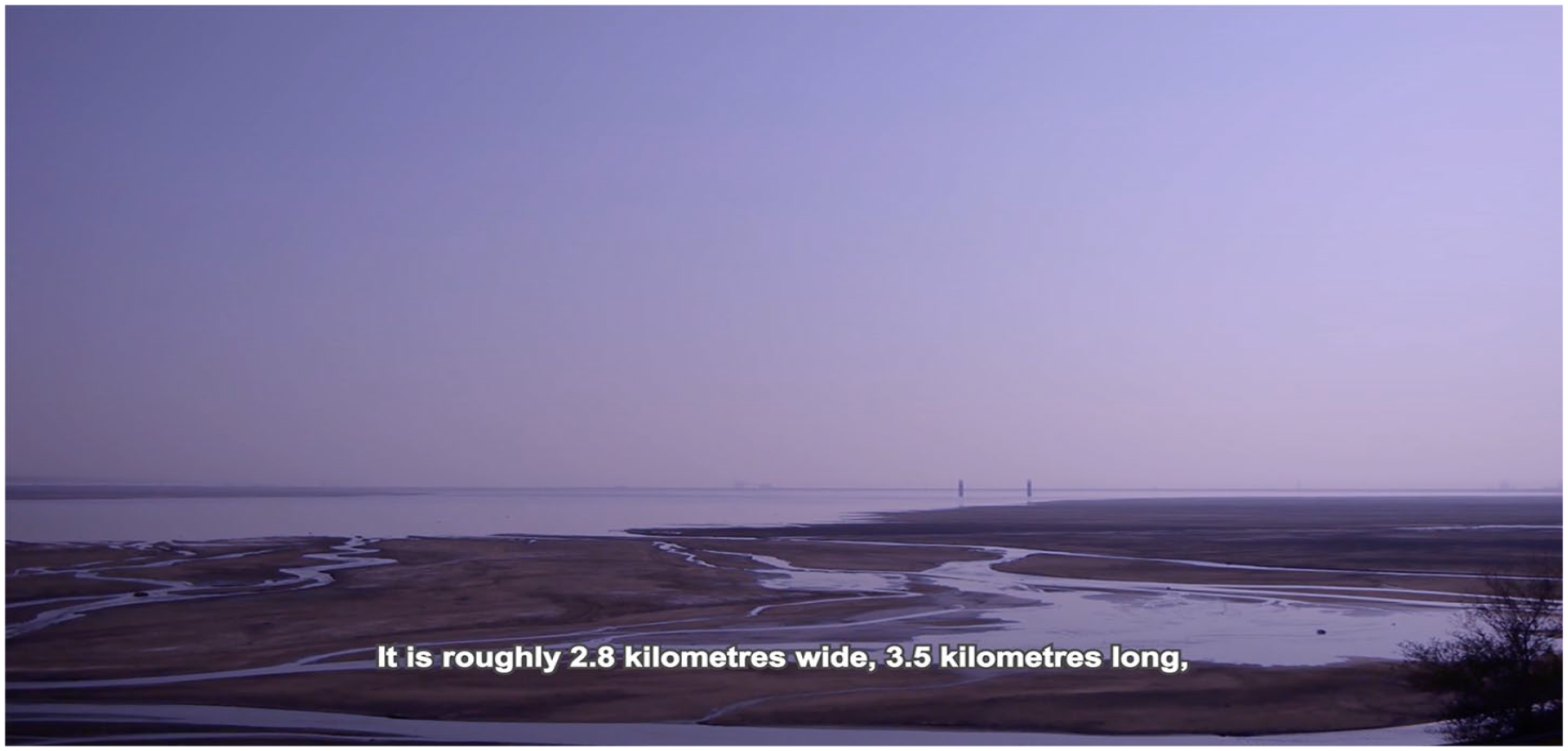
Still from Robert McDougall – Rare Earth (2021). Reproduced with permission.
Faced with these statistics, in which the volume of waste products from rare earth manufacture are 50 times the volume of the metals produced and heavily contaminated with uranium and thorium, it is difficult not to see the technical capacities these elements enable as pyrrhic – coming at such a vast ecological cost that their use value should perhaps be called into question, or at the very least accounted for and regulated. This ratio of 50:1 for rare earth elements gives us some sense of the scale of the inverted cone of perspectival vision I invoked earlier, and yet this accounts only for the relationship between product and waste material at the site of refinement, excluding the material footprint at Bayan Obo where the raw materials are mined, the emissions generated in both processes and the shipping of raw materials. And all this is before any functional object has even begun to be manufactured. In her book Rare Earth Frontiers (2017), geographer Julie Klinger describes places like the Weikuang Dam tailings as ‘sacrifice zones’, writing that ‘the destruction of landscapes and lives in pursuit of rare earth mining has generally been considered a fair price to pay, generally by those who do not live in the sacrifice zone’ (p. 12).
Neither Rigby, McDougall or myself live in or near such a sacrifice zone, and the production and distribution of digital artworks are equally implicated in the material and social injustices borne of the globally digitized economy of images through which such work circulates. As McDougall says in the opening sequence of Rare Earth, he shares ‘total complicity in every stage of an epic, extirpating drama’. McDougall and Rigby have both explicitly chosen to work with images and methods directly implicated by their own critiques. To some extent, this also reflects the condition of the satellite images they have both worked with, whose aerial perspective powerfully evidences the environmental scale of the degradation they themselves contribute to. Rigby (2022) even gestures towards the circularity of this position in the engravings found on her Satellite Minerals, some of which are ‘diagrammatic depictions of the satellite that took the image of the mine/quarry that resided on Google Earth when the sample was acquired’. This embedding of critique within the material of its subject is reminiscent of the argument posed by Michelle Henning in her contribution to Residual Media (2007). Henning writes convincingly of the power of obsolete media – once the embodiment of a certain promised lifestyle – to critique, by their very material persistence, the failure of that promise to materialize. A similar logic is at play here, wherein Rigby and McDougall both turn the gaze of the industrialized digital image onto its consequences, forcing the image to reveal its own shameful collateral.
Circularity
In one of the few essays to tackle the reliance of photography on resource extraction, Siobhan Angus (2021: 57) argues that ‘the relationship between mines and photography is not a linear movement that sees raw materials transformed into commodities, but a more complex interplay between the two.’ She uses the example of a real photo postcard of a strike at the Cobalt Silver mine in Canada in 1907. Describing the material trajectory in the image she writes: Silver, materially transformed by metallurgical processes from the raw silver ore extracted in the mining camp, returned to the site of extraction to circulate the perspective of the worker: to communicate with supporters, labour activists and families. (p. 70)
Angus identifies a circularity from the production of the raw materials through which photography materializes to their communicative function in conveying the experience of labourers at their origin. Considering the metals used in earth observing image sensors, we can trace a similar arc in which silicon, germanium, indium, gallium and other metals are processed from rocks and alloyed into optical semiconductors. The images they acquire on drone or satellite missions are now routinely used to analyse the mineral composition of the ground below. So, here, raw ores are refined into imaging instruments and sent into orbit to prospect for new orefields, the refinement of which precedes the manufacture of all camera hardwares. The trajectory between minerals and images in this instance is one of recursive circularity: images are used to produce minerals which are used to produce images.
Remote sensing then provides an example of circularity in the relationship between image and geology. But this is not the circularity imagined by the European Commission’s report on critical raw materials: a still somewhat theoretical model of the Circular Economy, in which end-of-life devices and manufacturing wastes are mined for their raw materials, reducing the need for new extraction sites. Quite the contrary of this ambitious and problematic model, one of the most notable consequences of digitization – the machine legibility of images – has led to a rapid and much commented-on expansion of the use of images within technical processes, what Harun Farocki presciently foresaw as the rise of the operative image (2001). Multispectral or infrared imaging is now proposed as a machinic outsourcing solution in numerous realms of visual inspection: crops, food packaging, forests, infrastructure, logistics, pharmaceuticals, carbon emissions, the sorting of recyclable waste – all can be supported by infrared image analysis, leading to a massive increase in demand for the critical metals which enable visual access to infrared spectra. A technique initially developed for astronomical imaging and available only to national and international space agencies is now fast expanding through implementation in multiple industries. In its airborne variants, the availability of consumer drones and portable multispectral cameras make infrared image analysis accessible on even modest budgets. Furthermore, circulating just metres above the ground dramatically increases the pictorial resolution of one’s data, and therefore – in geological applications – the accuracy and granularity of one’s mineral forecasts. However, this potentially dramatic shift in the ratio of pixels to cms expected in geophysical prospecting is matched by an increase in the technical consumption it engenders, with whole ranges of new commercial products and services being brought to market, and concomitant increases in data storage and computational energy exhausted in their analysis. This increase in pictorial resolution is echoed by a dramatic expansion of spectral resolution, further proliferating technological consumption and data production. The multispectral standard that distinguished generalized portions of the spectrum is now being replaced by a hyperspectral ability to image individual frequencies. In the geological gaze of current prospecting projects for technology metals, the circular relationship between resource and imagery is far from one that enables a circular re/production of those materials, but conversely, one which has the capacity to further accelerate an already catastrophic rapacious consumption.
Sensing, writing, shaping
In this example of geological prospecting, the circular relationship between image and landscape cycles through the three modes of environing identified by Sörlin and Wormbs (2018): sensing, writing and shaping. Sensing is an integral capacity of the instrument, the data collected from remote sensing surveys is then used to analyse and annotate its representation – inscribing understandings of the landscape as distinct raw materials and thereby establishing the terms by which it will become shaped in order to extract the profitable material.
Taking the example of the Sentinel 2 satellite, sensing takes place across 12 distinct bands that far exceed visible light. In the resulting spectral data visualizations, colour bears no relationship to human perceptual experience but becomes a manipulable construct in which R, G and B no longer correspond with the sensitivities of retinal cones but are ascribed to different spectral bands for different analytical purposes. The trichromatic synthesis of biological sight is appropriated to visualize various qualities of the reflection and absorption spectra of the surface. The epistemic priorities I cited earlier are mirrored in the descriptions of these spectral indices: forestry coverage band, soil adjusted vegetation index, atmospherically resistant vegetation index, chlorophyll index, agriculture, healthy vegetation, vegetation analysis, normalized difference water index, atmospheric penetration, atmospheric removal, normalized difference snow index, deforestation index and fire detection index.
In each of these visualizations, spectral bands are combined mathematically, so, for example, the deforestation index is calculated by the following equation: the sum of green plus water vapour, multiplied by the sum of the two shortwave infrared bands. Light and non-visible spectral radiation become inputs into chromatic equations, which write out our understanding of our environment. As Nicole Starosielski (2019: 150) has written, this thermal media gaze ‘recasts the world as a series of differentiated areas: healthy and unhealthy, normal and abnormal’. These photographic operations render the planetary surface as codified and calculable, reinforcing the perceptual effect of the vertical gaze mentioned above through a spectral technics of colour. The operative image of multispectral remote sensing produces an operative landscape, whose resources and productivity can be monitored and optimized from orbit. These images shape the landscape by predetermining the epistemic framework through which we conceive the ground.
And this methodology is now being extended to mineral mapping, by multi- and hyperspectral camera manufacturers such as the Finnish company SPECIM, who advertise their spectral imaging techniques to geophysicists. Several scientific research projects are currently underway to prove the viability of this technique in search of suddenly valuable deposits of the critical raw materials required to resource the digital economy and energy transition away from fossil fuels. Photography – whether at the level of consumer technologies or international satellite missions – is deeply implicated in this resource race. Gregory Bateson (1972: 407) writes that the subject matter of cybernetics ‘is not events and objects but the information carried by events and objects’, and in the case of geological remote sensing what Bateson refers to as ‘the informational aspects of nature’ are emphasized twofold. Not only does this spectral imaging technique interpret the reflection of light and other electromagnetic radiation in a purely informational manner that obscures the value of landscape, habitat, or wilderness. But, in doing so, it exclusively prioritizes the materialities of rock that are used in the manufacture of informational instruments with which to create, process and transmit data. The application of the informational technique of spectral sensing to terrestrial space reduces the conception of the planetary surface to its cybernetic potential. To take two examples – the capacity of quartz to transduce vibration into electrical energy, or the radioactive emissions of the uranium and thorium in pegmatites – these informational capacities first allow prospecting surveys to target them with their instruments and subsequently allow the extracted material to be exploited to carry the information or energy that is currently deemed more important to human cultures than their capacity to form and maintain the planet we inhabit. The epistemic images of remote sensing go much further than being ‘digital approximations of remote realities’ (Parks and Walker, 2020: 8), they are instrumental abstractions which obscure the lived experiences on, and ecological value of, the ground they depict in favour of shaping the earth as an informational resource whose mineral reserves should be capitalized upon. In the multispectral vertical gaze, the value of landscape is one that can only be grasped through extraction.
Conceiving of resolution as something which begins in the ground rather than the instrument emphasizes that this extractive gaze is merely an extension of the already extractive nature of the technical image. The manufacture of the camera shapes the earth before it has recorded an image. The consequences of its images continue to shape it in the same manner. Increasing demand for digital image technologies lays waste to a variety of ‘sacrifice zones’ across multiple continents, while sensors mounted on drones and satellites scout out more territories ripe for extraction. The technical image is being operationalized to feed its own reproduction. Capturing the Earth photographically is both preceded by and a prelude to a capture of its mineral reserves.
Emissions governance
What would be the consequence of re-thinking resolution as a measure of terrestrial cost rather than one of image quality? Can we meaningfully connect megapixel counts to megawatts of energy consumption and megatons of carbon emissions to accurately assess the ecological cost of producing and sustaining what Flusser (2011) called the Universe of Technical Images, which a large proportion of the planetary population now seem to inhabit more than they do the landscapes from which these images appear. In some sense this follows Weizman’s (2017: 274) call that ‘aerial photography must not only concern itself with reading the surface captured digitally or on film, but also with the technology and politics that placed the camera up in the air in the first place.’ For Weizman, this refers primarily to the military and state agencies which dominate and benefit from orbital and airborne surveillance. But we could also read this dual perspective on aerial imagery ecologically, as I have done here. To conclude, however, I would like to try connect the two, to offer an example which locates the political power generating the image and the collateral landscape generated by its production in relation to one another.
One recently proposed application of remote sensing is in emissions governance. Projects are underway both in the European Space Agency and the US private sector for satellite missions whose capabilities include remote measurements of carbon dioxide and methane emissions from each pixel of their hyperspectral imager. The ESA project, dubbed CarbonSat, has been explicitly designed to address the Kyoto protocol’s requirement for independent verification of emissions reporting. Its technical specifications were conceived to enable accurate monitoring of emissions from individual power plants and, in the (2010) paper outlining the remote sensing technique used, the scientists mention the rapid increase in the construction of coal-fired power plants in China and India as a contextual motivation in its development (Bovensmann et al., 2010).
The concept of CarbonSat was developed at the University of Bremen, and the satellite is now being manufactured by German company OHB for a (2025) launch. The European Space Agency and OHB have published factsheets which discuss at length the rationale and technical specifications of the mission. I can find out very quickly that the constellation will consist of five satellites, each with a 500m swath, so together covering 2.5km on each orbit – a width that enables the constellation to image the entire earth every day. The spatial resolution of its images is relatively low at 2km/pixel, but its spectral resolution enables it to distinguish reflected wavelengths of 0.1nm in the near infrared and 0.3 and 0.5nm in its two distinct bands of shortwave infrared. It will transfer this data back to ground stations at 320Mbit/sec. It is, in short, easy for the general public to access an obsessive level of quantitative data regarding the instrumental specifications of the satellite. However, when it comes to its materiality, the sources and trajectories of its constituent raw materials are entirely opaque; all we know is that the constellation will weigh 750 kg. Accounting for the mineral origins of those 750 kg of metal is currently neither an industrial priority nor a regulatory requirement. So, it is left to artists and researchers such as Rigby, or Matthew Hockenberry and Colette Perold (whose web platform, Manifest, 2023, visualizes and documents the supply chains, production lines and trade networks involved in the manufacture of numerous commodities) to retrospectively piece together the material trajectories engendered by its production.
However, for the sake of this article, let us trace a hypothetical material trajectory of the minerals in CarbonSat. In the currently globalized economy, it is safe to presume that the minerals refined for this satellite came from at least three continents, and very likely include China and Australia, who are together responsible for a large proportion of the fast-developing global trade in technology metals. For example, any rare earth elements used could well originate at the Bayan Obo mine (Figure 4) and have been refined in Baotou. These metals, extracted and refined in China, are then probably not exported directly to Germany as, although OHB is responsible for building the satellite, it will more than likely source many of the components for CarbonSat from subsidiary contractors worldwide. These components are then assembled in Germany, and will be launched from ‘Europe’s Spaceport’ which is not in Europe at all, but in French Guiana. The images from these satellites will be transmitted to the ESA data centre, which is actually within European territory, in Madrid, where they will be analysed in order to provide evidence for the enforcement of emissions commitments by, among others, China. To summarize, a technology whose hazardous production phases and toxic by-products are performed in and absorbed by the Global South will then be used to ensure that the carbon emissions generated by these heavy industrial processes do not exceed commitments made at international climate summits.
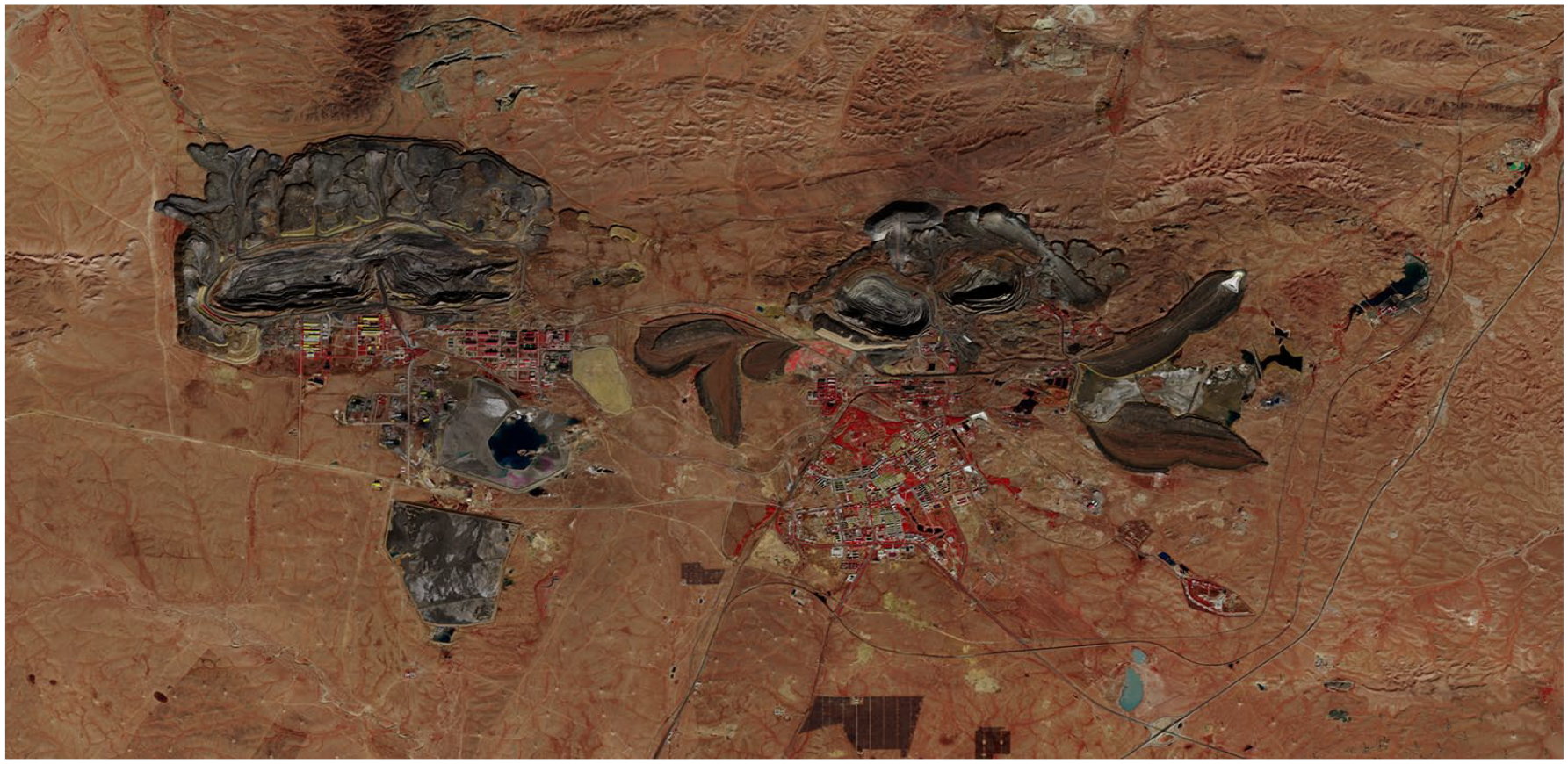
ESA Sentinel 2 infrared image of Bayan Obo rare earth mine, Mongolia.
The cyclical trajectory of minerals being used to create images which are then used to locate further minerals here takes on a post-colonial hypocrisy in which not only are high-tech imaging systems used to monitor the energetic expenditure of their own production, but this recursive relationship is enacted across a geopolitical imbalance in which the agencies demanding raw materials could end up using them to moralize the suppliers over the environmental costs of their extraction.
Conceiving of resolution not simply as a quality of an image but as the holistic material footprint of producing a photographic technology and maintaining open access to its data might bring us to a more relational understanding of image and ground, pixels and planet: that the spatial relationship between the two is never only one of abstract measurement but always also one of direct reliance. Images come from the ground, and their very production entails environmental damages that should also be accounted for in the technical specifications of our instruments. Understanding and articulating the ecological double bind at the heart of remote sensing projects such as CarbonSat might enable exactly the kind of ecological cost–benefit analysis that it itself is bidding to enforce. If we acknowledge and account for the material footprint of industrial production then the incidental and unintentional environing performed by technologies with which we image terrestrial landscapes come into sharper view. By inverting resolution, we can see that the relationship between camera and landscape, between image and geology, between earth and earth observation is always a reciprocal one, physically and photographically. The camera is shaped by the landscape and the landscape is shaped by the camera.
Perhaps what look, to our anthropocentric eyes, like photographs are merely the ephemeral optical by-products – the cultural effluvia – of a continuous planetary photochemistry. Thinking photography from the ground up allows us to see the planet as a photosensitive surface caught in a perpetual orbital solar exposure and to see its terrain as a mineral emulsion that captures inscriptions of our activity and reveals its materiality through its albedo: the relative reflection and absorption spectra of light falling upon it. What if, rather than always thinking of the construction of instruments and their outputs as the aim, the product and the outcome, we considered the collateral landscapes left in their wake as the major cultural contribution of our industries. Then it becomes the quarry and open-pit mine that are the real legacy media: the polluted pixels of the Weikuang Dam and the Atacama Desert, the over-exposed landscapes of Bayan Obo and Mount Toromocho, and numerous other exploited zones that will remain as the World Heritage Sites of the information age.
Footnotes
Declaration of conflicting interests
The author declared no potential conflicts of interest with respect to the research, authorship and publication of this article.
Funding
The author received no financial support for the research, authorship and publication of this article.
Address: Winchester School of Art, Park Avenue, Winchester, SO23 8DL, UK. [ email: