
Abstract
The Overland Telegraph system linked Australia to nascent global information and communication networks. Its arrival marked a key milestone in what we call Australia’s ‘telegraph time’—a fifty-year period from 1854–1904 when telegraphic systems were a significant driver of changes in economic, political and cultural activities. This British colonial infrastructure also marked the beginnings of the displacement of First Nations people along the route. In this paper, we explore how a multi-method and cybernetic, or complex systems, approach to the study of large-scale systems like telegraphy can make these histories and heritage more legible and meaningful today. We combine industrial, historical and indigenous archaeologies, systems engineering, cultural anthropology, photography, and critical theory to research the Overland Telegraph Line (OTL) and, in so doing, better reveal the socio-technical scale and impact of the OTL as a circulatory infrastructure. Our multi-disciplinary study of the ‘flows’ of the OTL—the material, the archival, the decommissioning, the repurposing, and the corridors of connection that remain—make visible its workings and highlight its enduring impacts. This multi-methods approach case study provides a model for archaeology generally, but especially the archaeology of linear features, such as pathways, journeyscapes, Songlines and linear infrastructure.
Keywords
Introduction
Writing the history of 19th-century telegraphy can be straightforward—primary source documents, reports, photographs, and even engineering specifications can all render the technology visible (Curtis and Pearcy, 1988; De Percy, 2021; Livingston, 1996; Moyal, 1984). But understanding telegraphy as a socio-technical system requires encountering its materiality, management and day-to-day impact, and also its enduring consequences. It can be seen in laws, regulations, contracts, as well as archaeological sites and human encounters, both past and present. This way of making sense of 19th-century telegraphy requires a multi-disciplinary, multi-methodological approach to truly make it visible and legible in the present.
Over the last 30 years, we have been exploring, encountering and even building large-scale socio-technical systems (Bell et al., 2021a, 2021b; Bell and Dourish, 2011; Paterson, 2008, 2011; Traw, 2001) and we draw on our diverse disciplinary backgrounds and expertise here. As scholars, we have been especially interested in how we might bring a cybernetic, or complex systems, approach to the study of large-scale systems like telegraphy (Bell, Gould, and O’Brien et al., 2023; Bell et al., 2024; Carey, 1983), and in so doing, find new ways to interpret them and make sense of their enduring impacts.
In Australia, the Overland Telegraph Line (OTL) is one such large-scale system (Clune, 1955; Gooley, 1972; Pugh, 2022; Taylor, 1980). Constructed between 1870 and 1872, the continental portion, the Overland piece, consisted of eleven purpose-built Repeater Stations spanning Adelaide to Port Darwin connected via thousands of kilometers of wire and poles (see Figure 1). At the time, it was the longest land telegraph project ever completed. Its impact, however, derived as much from the fact that it connected Australia to the rest of the world via submarine cables, as from the sheer scale of the land-based engineering project. In linking Australia to the emerging global information and communication networks, the OTL represented an important milestone in what we call Australia’s ‘telegraph time’—a fifty-year period from 1854–1904, when telegraphic systems were a significant driver of changes in economic, political and cultural activities (Bell et al., 2024). Map of the Overland Telegraph Line, 2024. Created in collaboration with John Frith.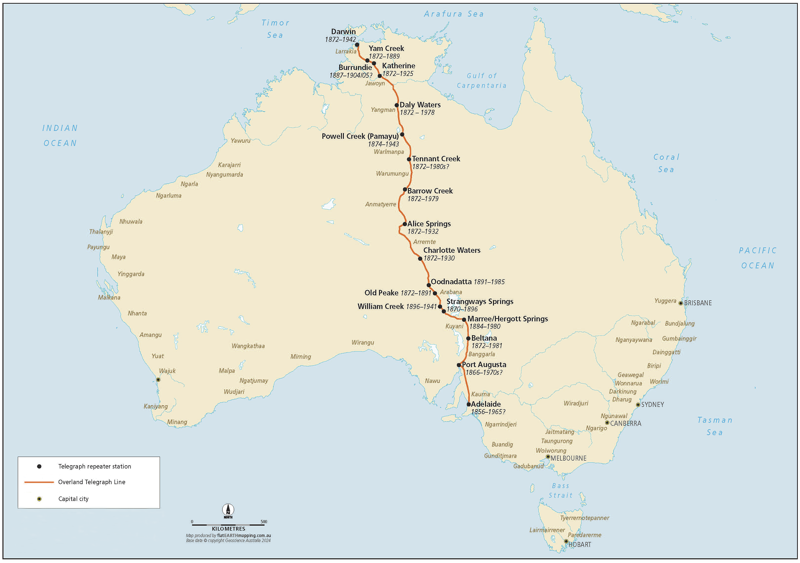
The development of an Overland Telegraph across Central Australia represented the beginnings of colonialism and invasion. As it cut north from areas settled in the 1850s and 1860s by farmers, the line bisected the traditional lands of Arabana, Arrernte, Anmatyerre, Kaytej, Warumungu, Warlmanpa, Jingili, Yangman, Jawoyn, Wagiman and Kungarakany nations, and arrived to meet the emerging submarine cable on Larrakia country, where Darwin is today. The arrival of Europeans and their technology featured in the history of claims for land recognition—e.g., ‘[t]he alienation of Warumungu land began with the building of the overland telegraph line in 1872’ (Bell, 1982: para 4). Many forms of European settlement in central Australia such as sheep and cattle stations, or state infrastructure such as police stations and ration depots (Rowse, 2002) were abandoned when they faced environmental, fiscal and other challenges. However, as the telegraph line was a connected system that required every element to work, abandonment was not an option. Aboriginal resistance was met with force. The most infamous example of cross-cultural violence occurred at Barrow Creek in 1874, when Kaititja warriors killed two telegraph workers as a reprisal for kidnapping Kaititja women (Ryan et al., 2025). The police responded with reprisal expeditions involving staff from Barrow Creek, Tennant Creek and The Peak Telegraph Stations in which over six weeks up to 80 Aboriginal people were murdered (Bell, 1983; Nettelbeck and Foster, 2007).
The route of the telegraph created a spatial template for the invaders, one which saw Europeans occupying resources and routes previously preferred by Aboriginal people. While the order of European colonial institutions varied along the line, the ingredients of colonisation were similar—the telegraph system, pastoralists and their animals, the police and rations depots. Many colonial people were involved in multiple aspects of these activities, and certain sites acted as ‘super waterholes’ (Elkin, 1946) where Aboriginal people were drawn into colonial settlements (Paterson, 2008; Rowse, 2002). The OTL was not a neutral or natural process, and First Nations people were not passive observers—rather people reacted, attacked, and were drawn into the telegraph and its associated colonial companions. It is impossible then to see the telegraph system infrastructure as anything else but a colonial artefact of Empire, but with very local realities at the level of Aboriginal nations. The OTL was not benevolent or outside imperial and colonial thinking—it was a conduit for this ideology as well as a setting for colonialism and the activation of Indigenous responses, similar to elsewhere in the world, for example, with the arrival of the telegraph and associated institutions in Native American lands (Gage, 2020).
Throughout our research on the OTL, we have been attentive to First Nations voices and scholarship, such as the truth-telling work of director, producer and writer Kieran Mpetyane Satour’s commission for the National Communications Museum, The Truth about the Telegraph (Satour, 2024). We were fortunate to share some of our archival and fieldwork insights with Satour in the preparation phase of this project. We have also engaged with Aboriginal communities as part of previous research on archaeology and the OTL (e.g. Paterson, 2008).
Whilst Federation might have initially relied on telegraphy as an infrastructure of control and communication, rapid advances saw the adoption of new technologies—radio, microwave, television—that displaced telegraphy. For something that had been so instrumental, telegraphy disappeared, slowly at first and then all at once, until all that seemed to remain were lonely buildings, the occasional metal pole and the debris from broken insulators. Bringing together systems engineering, cultural anthropology, industrial archaeology, photography and critical theory, and building on our prior work (Bell et al., 2024; Bell et al., 2025), we wish to make visible and legible again the socio-technical scale and impact of the OTL, as well as the infrastructure.
A cybernetic approach to telegraphy
In this paper, we draw on a range of primary and secondary sources, including newspaper accounts, government documents, and photographs, as well as contemporary archaeological and heritage work. Our approach is centered on a cybernetic analysis of telegraphy as a socio-technical system that can only be understood through exploring the relationships between technology, the humans and the environment in which the system transpires (Bell et al., 2021b, 2023, 2024). Cybernetics offers an array of conceptual and methodological applications that enable multiple inquiries and the development of a shared language, helping establish a ‘legitimacy exchange’ (Bowker, 1993: 116) between and within disciplines. Examples include the Macy Conferences on Cybernetics, held between 1946 and 1953 (Heims, 1991) and the contemporary work of the Australian National University’s School of Cybernetics on cybernetic leadership (Gould et al., 2022) and on art and technology (Meares et al., 2024).
Architect and design theorist Ranulph Glanville states that ‘cybernetics studies circular systems and their consequences’ (2007: 1200). Examples of early cybernetic approaches to circular systems include: the work of neurophysiologist Warren McCulloch and logician Walter Pitts describing the nervous system as containing ‘many circular paths’, which helped inspire the design of John von Neumann’s EDVAC computer (McCulloch and Pitts, 1943: 117; Von Neumann, 1945); ‘purpose controlled by feed-back’ in the 1943 work of physiologist Arturo Rosenblueth, mathematician Norbert Wiener and engineer Julian Bigelow; and the illustration in the title of the inaugural 1946 Macy Conference on Cybernetics named ‘Feedback Mechanisms and Circular Causal Systems in Biological and Social Systems’ (Heims, 1991).
As the materiality of the OTL is largely an historical and archaeological project, our approach is also strongly influenced by the recent work of Wilkinson (2019) in theorizing infrastructure in an archaeological context. He defines infrastructures as: [L]arge and immovable technological apparatus that are distinguishable from more portable objects, (2) which imply supra-household communities in their construction and ongoing use, but (3) excluding most architectural structures, such as residences and other human-oriented buildings. (Wilkinson, 2019: 1223)
Wilkson’s idea of infrastructure feels akin to our socio-technical systems, and his ontology has useful methodological implications for how we might ‘see’ a system and engage with it. Indeed, his work is in productive dialog with many cybernetic concerns. His identification of a circulatory form of infrastructure that is designed to support transportation, or transmission, feels especially relevant to telegraphy. Inspired by the methodological work of sociologist Star, who states that ‘infrastructure is both relational and ecological’ (1999: 377), we seek to build on Wilkinson’s invitation to consider an infrastructure topology, as listed above, ‘ultimately to make sense of our assemblages’ (2019: 1237). We align our approach to telegraphy in a similar way to Wilkinson’s description of a port or harbour as ‘not really one kind of infrastructure, so much as a convergence of several different kinds, all operating together, and with each fulfilling different, often multiple, goals’ (2019: 1236). Thus, our consideration of telegraphy as a circulatory infrastructure is consistent with cybernetics’ origins and ongoing interests in circular systems, as well as our own interests in bringing this approach and its methodological implications to a range of our applications.
It is significant to Australia, and relevant to everywhere where a telegraph system occurred in colonial settings, that a cybernetic view of the telegraph necessarily understands the telegraph and its technical and social systems as an expression of the colonial world. An expanded view of the telegraph requires thinking about First Nations people and their Country. This is demonstrated by reflecting on the reality that the OTL was developed around natural water sources which were already significant to Aboriginal Australia. As described by Mike Smith, citing Judith Wright’s poem ‘Sanctuary’, the completed OTL was ‘like a long fuse’ (2005: 11) from which Europeans would explore and eventually settle. Archaeological sites reveal the spatial relationship of Aboriginal people to the telegraph stations as well as the use of new materials, for example, ceramic telegraph insulators being modified to produce flaked tools (Munt and Owen, 2021).
This paper is framed around three quite different but interlocking approaches to a large-scale, historical, socio-technical system—a circulatory infrastructure. In section one, we examine telegraphic routes and sites; in section two, we explore visual representations of telegraphy; and in section three, we share a critical self-reflexive pedagogy. Through these frames, we find ways to encounter 19th-century technology anew in the 21st century. In so doing, we articulate a methodological suite that could help examine other such large-scale systems from railways to electricity, the internet, and even data centers, and re/assert their legacies and lasting impacts.
Following the route—circulatory infrastructure and the sites in-between
The most obvious forms of infrastructure tend to be circulatory, and as the name suggests, they facilitate the dissemination and transport of people, animals, goods, resources, waste, and information. Common varieties include roads, canals, bridges, railways, aqueducts, viaducts, drains, sewers, causeways, and power grids.… Fundamentally, circulatory infrastructures are entities that remain immobile, so that other things can move. (Wilkinson, 2019: 1226)
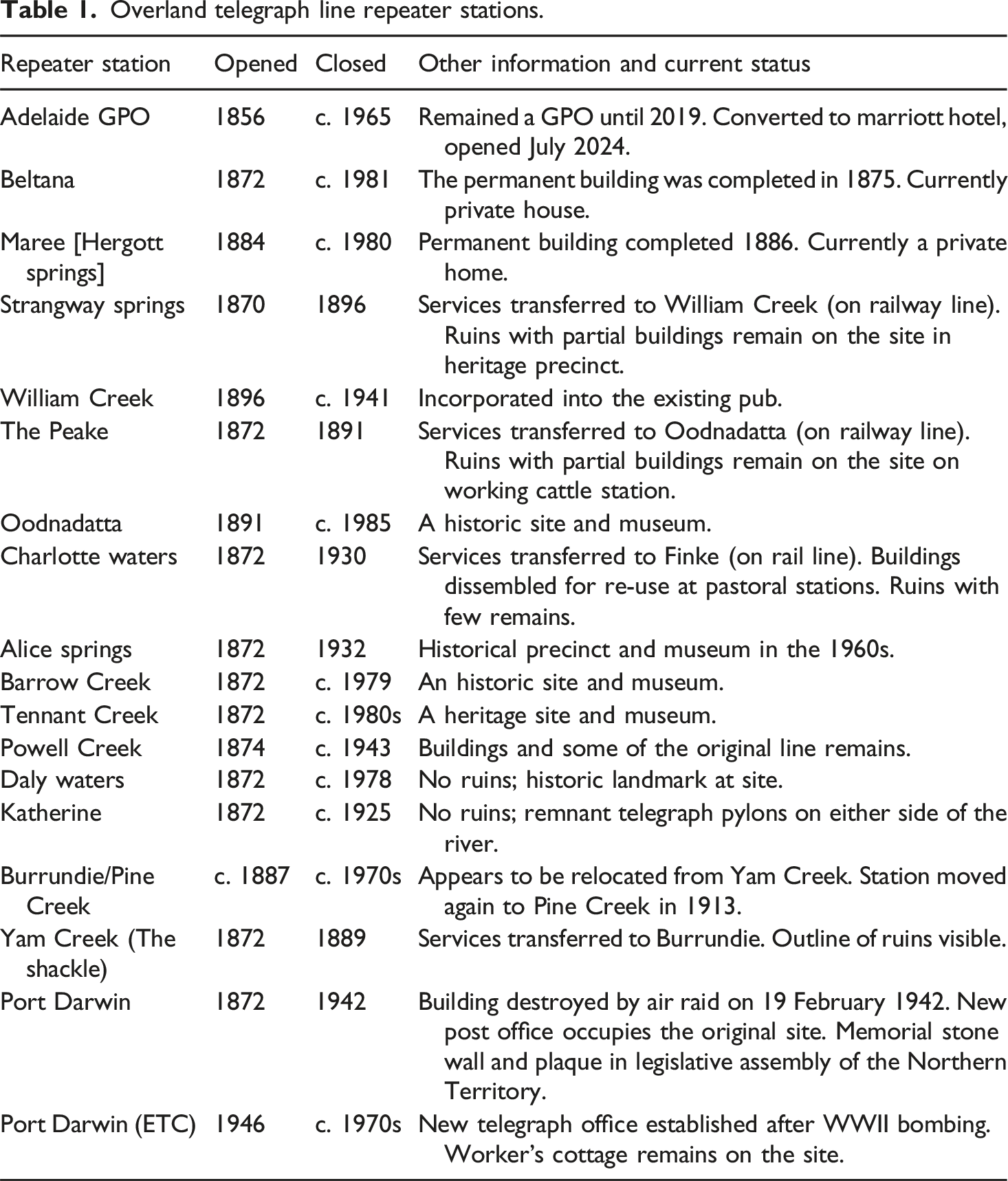
Overland telegraph line repeater stations.
Here we take Wilkinson’s idea of circulatory infrastructure as our point of departure. Specifically, we want to move from the Repeater Station locus to some of the network routes and flows; the spaces in between, the lines themselves and their reworkings, and the ways we might encounter them. After all, in many ways a telegraph line is a circulatory infrastructure. It is an immobile entity that facilities the movement of information. However, unlike a road or a railway, its route is a little less rigid, a little less immobile.
Beyond the fixity of Repeater Stations, 19th-century telegraphy was all about the route and its flows—flows of information, flows of electricity, even flowing wires. And in the case of the OTL, the line itself was repeatedly re-poled, re-wired, re-insulated and relocated, bypassing some Repeater Stations and building new ones. This suggests that 19th-century telegraphy, especially cast as Wilkinson imagines, might benefit from a more expansive archaeological gaze. Seeing the OTL as a large-scale socio-technical system, or infrastructure, means being attentive to its routes, not just its stations.
The route: In-betweenness and flow
The Repeater Stations are often seen as the sum of the OTL in Australia—several of them are museums today and their names are well known. However, in understanding and seeing the OTL, we have also come to identify the ‘route’ as an equally important site type. By ‘route’ we mean the telegraph line itself, which stretched between the Repeater Stations with key elements like cleared vegetation, removal of rocks, and repair. The route is reflected today in physical elements such as evidence of posts and poles, insulator scatter, and in places where the tracks or fences reflect the past geography of the line. At first blush, these artefacts suggest that a line once flowed here as an immobile entity. However, as an inventory of the Repeater Stations on the OTL shows (see Table 1 and Figure 1), the line was an evolving infrastructure—the buildings themselves changed in shape and function, flexing and adapting over time (Brand 1994). What Table 1 also makes clear is that the line in-between the Repeater Stations must have flexed and moved—the route was not stable, even if the messages that flowed through it were. Making sense of the OTL’s route then represents an interesting methodological challenge.
The OTL had a very particular kind of route infrastructure. Charles Todd (1836–1910), longtime Superintendent of Telegraphs in South Australia, and the architect of the OTL, preferred to build telegraph lines along existing throughways, and where that was not possible, he encouraged his surveyors to survey for both the telegraph line and also throughways. Writing in 1862, he was clear about his direction: A plan was adopted which I recommend should be pursued in all future line which many traverse unsurveyed districts, viz., that a line of road should be laid out simultaneously with the telegraphy so as to avoid an expense hereafter in shifting the latter to suit a road surveyed subsequently to the erection of the line. (Todd quoted in Gooley, 1972: 12)
In practical terms, this meant that the path of the telegraph line might also set the path for further roads, rail and other forms of infrastructure.
In South Australia, north of Strangways Springs, there were not yet clear European throughways, and the majority of the OTL had to be surveyed in real-time as it was being constructed (Clune, 1955; Richards, 1914; Taylor, 1980). The route did have specific requirements, most notably the need for reliable sources of water to support both humans and the batteries that electrified the line. In determining the path the OTL would take, different surveyors worked on Todd’s brief, the requirements of technology, and human needs. They located permanent water sources, identified paths between them and then Repeater Stations were built; land was cleared, holes were dug; poles were planted and wires strung. In many places, the route materialized in a season.
The original installation of the line called for a pole every 80 m — a distance determined to best support the transmission of data down the wire. In this regard, Todd’s orders were straightforward too: [T]he line is to be erected in a most substantial manner and the poles are to be placed not fewer than twenty to the mile. Where suitable timber is available, wood poles are to be used not less than nine inches in diameter at the butt. (quoted in Gooley, 1972: 10)
Over the years that followed the initial build, OTL linesmen worked to ensure that a chain’s length (20.11 m) on either side of the line was also permanently kept clear of all obstructions, to protect the line and prevent disruptions. The results sometimes created permanent changes in the landscape that remain present today and can be readily seen in satellite and drone imagery.
Within the Frew Ponds Overland Telegraph Memorial, south of Katherine, there are 52 Oppenheimer poles (Engineers Australia, 2012) still extant in an approximately five km line. Whilst they are not in their original 1872 locations, and the line is not being cleared a chain on either side, the poles are from a period when the line still functioned and was maintained. In situ, they give a sense of the sheer scale of the OTL infrastructure, and of its in-betweenness (see Figure 2). Frew Ponds Overland Telegraph Memorial, 2024. Photo: Andrew Meares.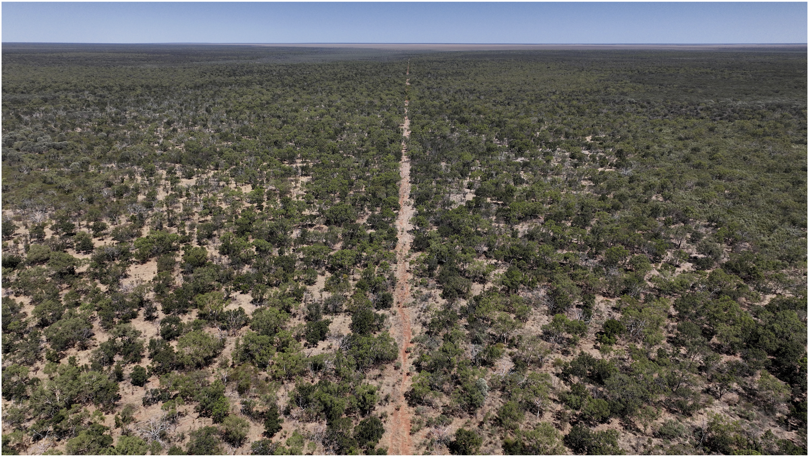
The initial building out of the OTL was completed in 1872, but for nearly 50 years the line was constantly updated, modified and relocated (see Table 1). In the late 1880s with the completion of the Great Northern Railway from Port Augusta to Oodnadatta, several Repeater Stations were closed, and the services were transferred to new sites closer to the railway and co-located (Austral Archaeology, 2001; Fuller, 1975; South Australian Register, 1896). During this period, much of the line from Beltana to Alice Springs was re-poled, with galvanized metal poles replacing the original wooden ones (Engineers Australia, 2012: 12–13). In the 20th century, with the aftermath of the nationalization of the telegraph network into the General Post Office (GPO) (1904), and the extension of the Great Northern Line to Alice Springs (1929), another flurry of activity transpired along the line with site closures and consolidations (NRETAS, 2011; NT Government, 2001). Ultimately, the adoption of new technologies—microwave links, telephony, satellite—led to the final decommissioning of the OTL in 1979: The entire Overland Telegraph Line was augmented many times. A second (copper) wire was added in 1899 and a third (copper) wire in 1941. After this there were major additions and augmentations, including the conversion to two wire voice circuits starting in the 1920s. A microwave link parallel to the wire circuits was also added in the early 1970s. Later still underground fibre optic cables were laid along the Stuart Highway. (Engineers Australia, 2012: 8)
This gradual decommissioning of the OTL was ad-hoc, patchy and poorly documented. Equipment and personnel moved when services moved. Systems were upgraded and old ones discarded (Engineers Australia, 2012: 17–18). Buildings were repurposed as homesteads, mining sites, and administrative centers. There are various reports of pieces of the OTL being removed and repurposed. For instance, Oppenheimer poles grace any number of verandas and gates from Marree to Darwin. In the case of Charlotte Waters, it is the building material itself that was removed: ‘Between 1938 and 1948 the station buildings collapsed and were progressively scavenged for use in buildings at Andado and New Crown’ (NRETAS, 2011: 9). When the telegraph line was officially decommissioned in the 1970s, the original route became harder to discern.
In some places, in-between traces of the route can still be seen (Crouch, 2020: 31–33; Engineers Australia, 2012; Gee, 2000: 55; Kent, 2003; Wilson, 1983) in solitary telegraph poles, remnant sand-anchors and wooden stumps, and insulator debris. A keen eye can find the line, in many places, with relative ease. Locate an insulator debris field, walk 80 m in the right direction, and you will find another and another—this is as true near Strangway Springs as Charlotte Waters and Powell Creek. We assume complete insulators have been more likely collected as curios, while fragments of broken insulators remain.
Pieces of the OTL were even overwritten by other forms of infrastructure — railways and roads principal amongst them (Engineers Australia, 2007). In some places the route can also be seen today not in the material remains of the 19th-century telegraph system, but in the throughway that developed along the route, between Repeater Stations, along the telegraph poles: a dirt track that ultimately became the Oodnadatta Track in South Australia and the Stuart Highway in the Northern Territory (Engineers Australia, 2007; Nicol, 1978). The telegraph route also became a road. Different kinds of infrastructure shared the same space, with the Repeater Stations anchoring not just data transmission but also stock movements, travel and even tourism (Clarsen, 2008; Wright and Goldman, 1993).
In defining telegraph site types (Bell et al., 2024: Table 1), we did not attempt to articulate these kinds of decommissioned flows of materials, as they clearly do not represent traditional sites. They are more akin to artefact scatters. Even then, this is not how that idea is articulated as a research tool.
The OTL route was always more than just an infrastructure. More widely the route provided a permanent reference point that underpinned new forms of colonial surveillance across Australia. For the closing years of the 19th century, the OTL provided a geographical reference for European explorers (Forrest et al., 1875; Giles, 1875), scientists (Morton and Mulvaney, 1996; White, 1914) and colonists, and the line out from which much pastoralism transpired. The OTL bisected the continent physically and metaphorically, and in so doing fundamentally changed the lives of the Aboriginal people whose country it crossed. It was a sometimes-violent reordering of daily life and sacred sites in which Repeater Stations were flash points (Jones, 2023; Koch, 1993; Satour, 2024). Overtime, the Repeater Stations also were sites of policing, detention, ration distribution, kinship, and labour (Jones, 2023; Martiniello, 2003; Powell and McRae, 1996; Rowse, 2002; Wills, 2020, 2021). Individual poles on the route also became settings for cross-cultural negotiation. Insulators and spare wire were left at the base so that Aboriginal people did not remove them from the line itself, thus protecting the operations of the telegraph system while also providing material for fishing hooks and spears, and ceramic for flints (Jones, 2007). This evidence reflects the re-ordering of Australia’s colonial-era social landscapes and the consequences for Indigenous agency, as has been explored with other forms of routes in colonial settings, for example for railways in Australia (Duke, 2019), telegraphy in the US (Gage, 2020), and road networks in colonial New Spain (Staski, 2004).
As a circulatory infrastructure, the OTL’s route is not straightforward. The traditional narrative of the OTL focuses on the technology and the work required to build the system, and the resulting social and political consequences. However, the ongoing development of the system reveals ever greater levels of complexity over time. The telegraph system influenced the geography of the Northern Territory. Changes in the technology resulted in changes at the level of the site. For those parts of the systems that became abandoned we find archaeological sites comprised of ruins, artefact scatters and traces. But equally, we also need to examine how sites became transformed in use over time both during and after the telegraph system (Brand, 1994). Rendering the OTL visible and legible requires tackling not just its immobility but its various, interrelated flows.
Looking at the line: Visual cybernetics of the OTL
In this section, we turn to visual cybernetics as a generative way to encounter the socio-technical nature and scale of the OTL as a system. When it comes to the visual representations of 19th-century telegraphy, there is an interesting range of contemporaneous material—lithographic, photographic, and various forms of artistic representation, including sketches and paintings (Morash, 2020; Taw, 2025). Building on prior work with historic images and imaginings of the OTL and Morash’s (2020) analysis of global telegraphy imagery, here we take a more expansive approach to shape our thinking and focus ‘our attention on process and change’ (Kepes, 1956: 230) within the OTL. Put another way: seeing the system lets us encounter its scale and lasting impact.
Our application of visual cybernetics is participatory and performative in the way cybernetic artist and theorist Gordon Pask describes, where ‘interaction with the system is performed, and in which cybernetic hypotheses appear’ (1958: 172). This immersive and iterative feedback-informed approach to creating relationships between the visual archival materials and OTL sites and routes has framed our thinking, ongoing conversations, and new investigation methods and sites. It has also built a greater understanding of the OTL as a circulatory infrastructure system, its materiality and temporality (Ascott, 1964, 1968; Kepes, 1956; Glanville 2007; Pask, 1958; Pickering, 2024).
Our approach to navigating the archive draws inspiration from past literature on encounters with and use of archival collections (Andrews, 2024; Kovacic, 2006; Schwartz, 2000). Andrews’ call to ‘bring historical collections into direct relationship with the present’ and her desire to ‘purposefully disrupt disciplinary conventionality as a way to make room for other ways of building knowledge with objects’ (2024: 112) are especially helpful. We are also inspired by Schwartz’s call to be attentive to the role of the photographer, and the political economy of the image making, not just the photograph itself: The way archives appraise, acquire, arrange, describe, and make accessible photographic records depends upon our understanding of the role of photographs in the business of life and, indeed, in the life of business – personal business, group business, corporate business, government business. (2000: 40)
Likewise, we draw on Kovacic’s call to ‘explain, develop and expand the significance of the image, not narrow it down’ (2006: 99). In seeing and rendering visible the OTL, and 19th-century telegraphy more broadly, we are acutely attuned to the work that this imagery can and should do. We do this through two key approaches outlined in the following.
‘Here and now/there and then’ visual comparisons
In attempting to see the scale of the OTL and to render it visible again in the 21st century we have turned to an approach that allows for a visual comparison of what remains today with what archival photographs show of the same location. We travelled to OTL sites with archival photographs depicting that site printed to a large size and laminated. This enabled us to match significant features in the photograph, such as horizons, sunlight direction, and the built environment, to any similar features and absences remaining at the site. We call this method Here and now / there and then. This method was informed and constrained by the visual documentation in the archive dataset depicting the construction, modification and decline of the telegraph Repeater Station buildings, and the infrastructures and people associated with the OTL. Seeing the site and the archival depiction of the site together provides the capability for the reader to ‘see’ or imagine changes and absences (Bear and Albers, 2017).
Acting as participant-observers, by both making and interpreting photographs, our interpretation of the contemporary OTL sites opened up a new visual dialogue with the OTL archival records, and vice-versa. Beyond accumulating site and object documentation, this interactive and immersive photography practice enhanced our capability to contextualize and see the ‘in-between’ of the OTL. In turn, this process revealed the benefits of a visual cybernetic approach to our substantive enquiries.
For example, we have applied this method to two photographs of the Strangways Springs Repeater Station found in the South Australian State Library collection—SLSA B1490 attributed to 1876 and SLSA B1487 attributed to 1872. Both physical descriptions of the records in the State Library of South Australia note they are ‘Negative (glass plate); 20.5 cm × 25.5 cm.’
Our close examination of the Strangways Springs Repeater Station in SLSA B1490 revealed a dog as well as the rendering of the shadow of a dog projected on the sun-facing wall of the main building. Due to the length of the camera exposure, likely in excess of three minutes, a shadow of a dog sitting, as well as the dog lying down, was rendered on the emulsion. Given the extreme summer temperatures at the site, we surmise this image was made in the cooler months with the dog seeking warmth in the morning sun. This revelation offered us a more expansive understanding of the visuality of process and change, even within the limited confines of a single archival photograph’s exposure.
Our process of correlating image features to site features while standing in the very location of the archival photographer revealed that SLSA B1490 and SLSA B1487 could, in fact, be two images designed to be joined. Taken together, these two images show all the buildings at Strangways Springs, perhaps motivating the panorama approach popular in the period (see SLSA ‘Panorama of Adelaide’, 1870, B16004). By overlapping the images to create a two-frame panorama (Figure 3), there is a consistent horizon line, sunlight direction, and exact matching of foreground features. Despite the discrepancies in the metadata date attributions, it seems likely these photographs were taken at the same time, from the same tripod location, with the same camera system. Composite panorama achieved by placing SLSA B 1487 over SLSA B 1490. Photo: State Library of South Australia.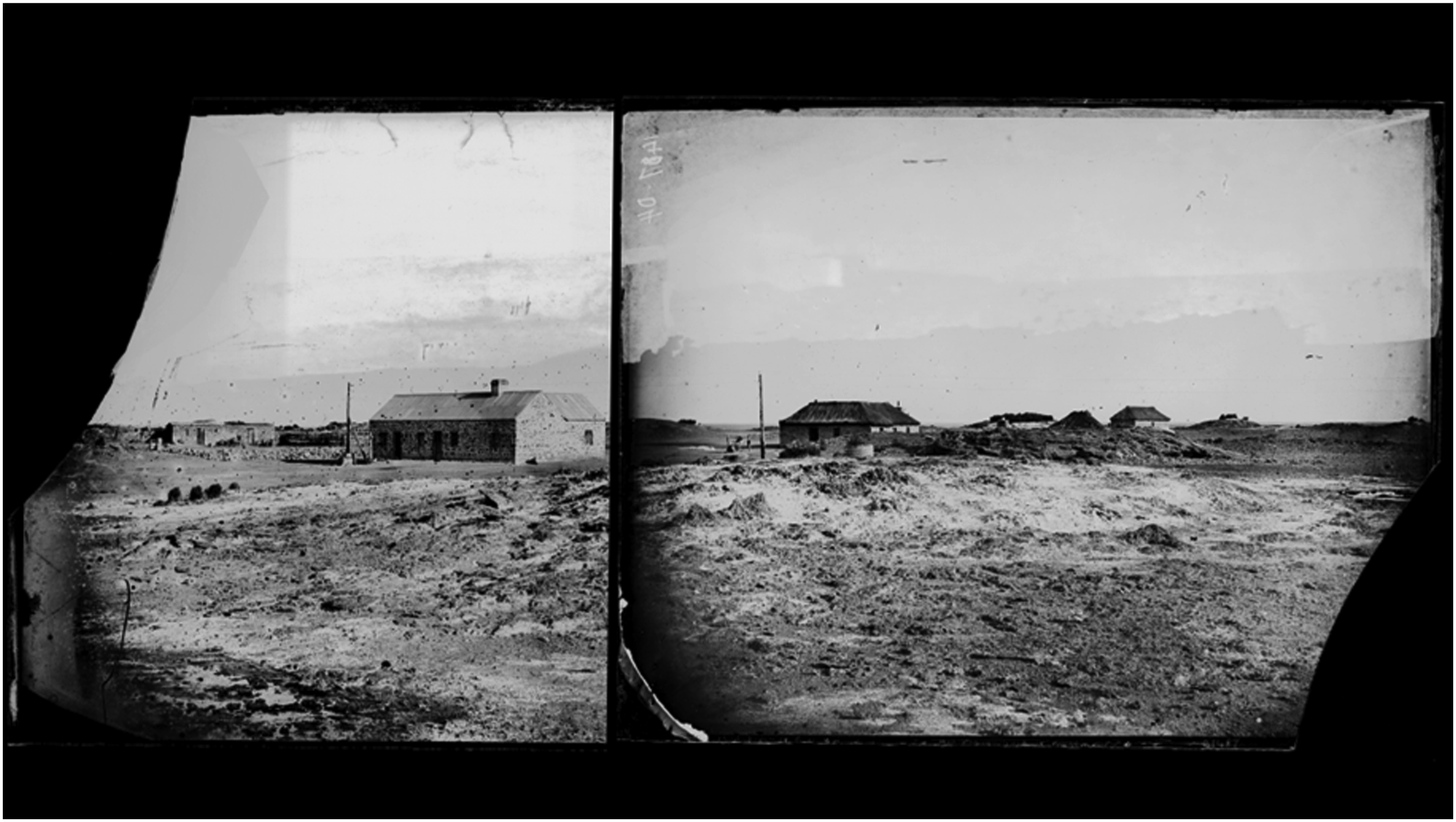
While on-site we took a series of contemporary photos from the exact same spot to match the focal length and coverage of SLSA B1487 and SLSA B1490. To help see the past in the present, we digitally traced the building outlines and infrastructures from the archive images and transposed these onto the photo made in 2022 (Figure 4). Strangways Springs Repeater Station, 1870s. Building outlines traced from archival photographs (SLSA B1487 and B1490) overlayed on a photo made in 2022 from the same origin point. Note the water tank seen in the 2022 image was not present when B1487 and B1490 were made. Photo: Andrew Meares.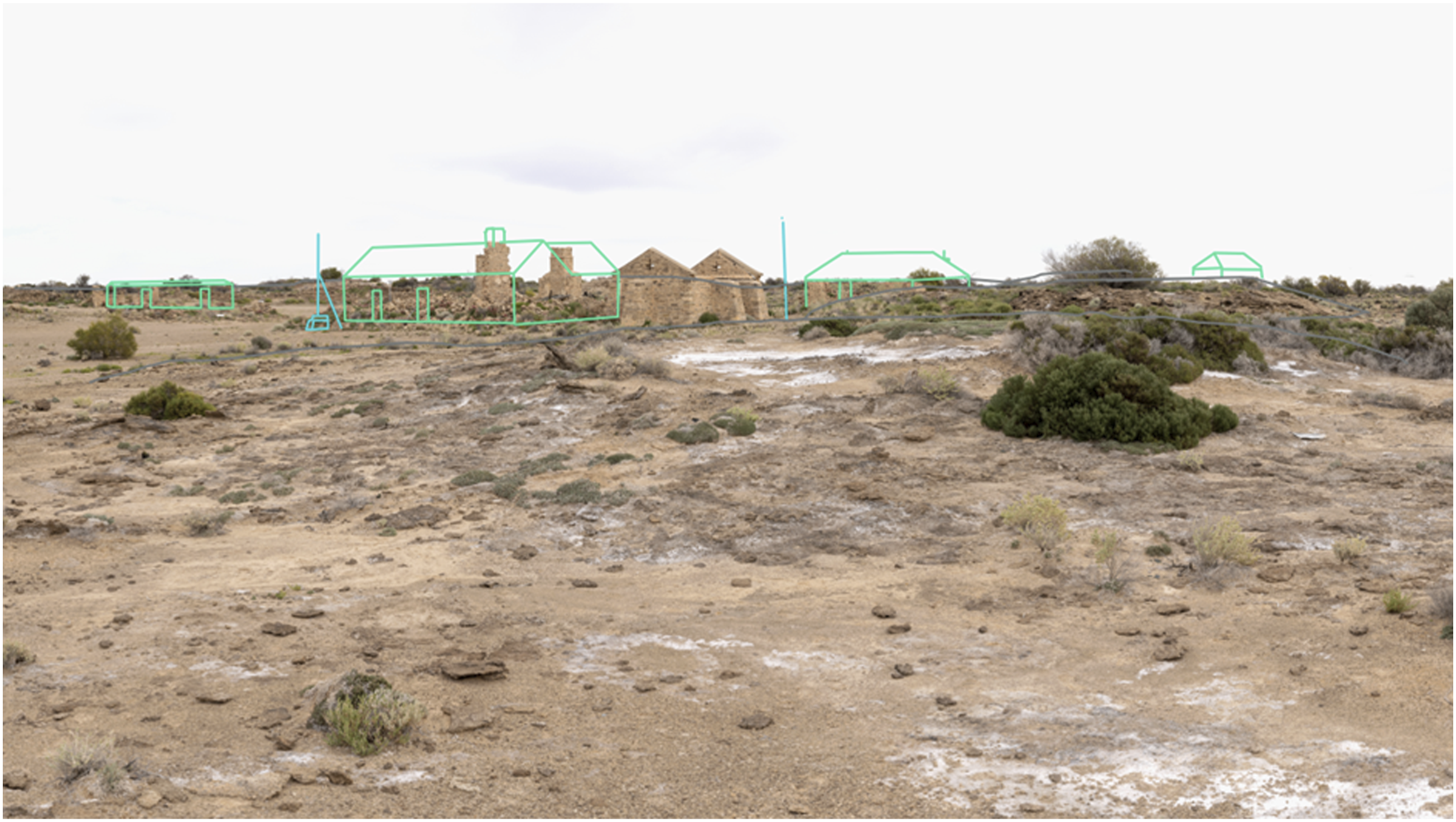
This approach created a useful cybernetic feedback loop—interpreting the archive records in-person during site visits would then inform a re-reading of the archive records, which in turn would better inform a re-reading of the site in-person on a repeat visit. Beyond the direct reading of the indexical aspects of the Here and now / there and then photographs, this visual comparison, as with our awareness of the dog and its shadow, ‘render duration visible and legible’ (Bear and Albers, 2017: 3). By enabling the in-between period to be imagined and reimagined, contextual explorations via visual cybernetics help us to ‘see’ change and systems over time (Bear and Albers, 2017: 3).
Analogue photography practice
Building on the participant-observer stance of visual cybernetics, we have also explored our observation of and interaction with the OTL system and its archive materials using an analogue mechanical camera with a 4 × 5-inch black-and-white film processing photography practice. This approach initially came from a frustration with the contemporary digital photography image resolution compared to the exceptional film resolution quality seen in the glass plate photographs in the archive described above. We obtained a 1947 Crown Graphic camera that uses 4 × 5-inch film for this purpose.
The introduction of a technical constraint, in this case a large format mechanical camera that depicts the frame upside down and reversed in the viewfinder, only takes a single image at a time, in black and white, influenced our site appreciation and visual composition choices. Writing about cybernetic approaches to design, Fischer and Richards argue ‘[c]onstraints give direction’ and can ‘be used as a design exploration strategy’ (2017: 39–40). Their work builds on a foundational cybernetic approach proposed by W. Ross Ashby, who wrote ‘when a constraint exists, advantage can usually be taken of it’ (1956: 130).
As with the Here and now / there and then method outlined above, this analogue photography practice improved our understanding of the OTL archival records, and how and why those archival photographs were made in the context of their time. This practice offered an alternative image-making option to our contemporary digital and aerial imaging platforms (see Figure 5). By creating an image ourselves in a way similar to how the archive dataset was created from the 1870s to 1920s, we found new ways to interpret the site and new ways to appreciate our readings of the archival images. Left to right: Strangways Springs, Angle Pole Oodnadatta, The Peake, 2023. Photos:Andrew Meares.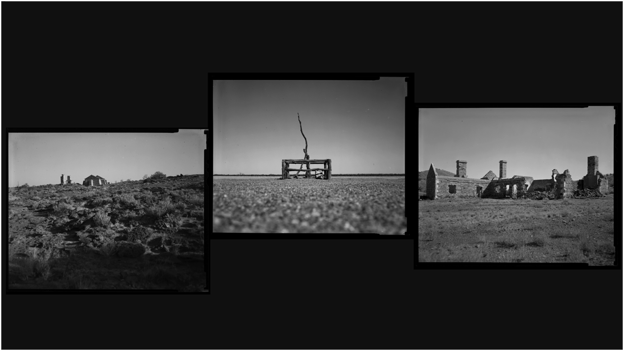
Applying an anachronistic image-making method to a legacy subject, but with a motivation to show a present representation (in our case, of a 19th-century technical system) helped create a liminal reading. Through the material, non-digital, photographic modality and intentional composition choices, as well as the black and white rendering, this approach extended beyond being only a research method. The resulting analogue image invites the reader to contemplate and question a temporal co-mingling.
Our consideration, exploration and application of these two visual genres—Here and now / then and there visual comparisons as well as an analogue photography practice inspired by and reapplied to the chosen visual data set images and field sites—have assisted in the reinterpretation of the OTL made visible, as a system, for both contemporary research practices and audiences.
Reflexive cybernetics: Putting ourselves in the system situated practice
In the context of our historical and socio-technical research, a ‘turning back on oneself’ is important, especially when on fieldwork and re/constructing narratives of the past. As put by Davies, scholars ‘in the field – and out of it – must seek to develop forms of research that fully acknowledge and utilize subjective experience and reflection on it as an intrinsic part of research’ (2008: 5). Informed by the work of Davies (2008) as well as Nippert-Eng (2015) and even Spradley (1979), reflexive practices are thus another key element of our methodology. While in the field, we complement our archaeological activities and visual cybernetics with a series of introspective and pedagogical exercises. These exercises are guided by the principle that ‘researchers are to some degree connected to, or part of, the object of their research’ (Davies, 2008: 3) and must therefore be ‘explored and put to creative use’ (Okely, 1996: 28). This line of thinking is also associated with second-order cybernetics where ‘the role of the observer is appreciated and acknowledged rather than disguised’ (Glanville, 2009: 59) and the observers, or researchers, are considered part of the ‘system’ (Mead, 1968; Richards, 2020; Von Foerster, 1995). Our in-field exercises, then, are a kind of social and cybernetic reflexivity framed by the following instructions each time: As part of this trip, we all have individual responsibilities and tasks. We will also be undertaking some shared tasks. These tasks are designed to experiment with different ways of telling stories, engaging with the material, and sharpening and honing curiosity. There are no “right” answers. We will collectively review the material at the end of each day.
Such ‘shared tasks’ are intentionally interdisciplinary and multimethod to generate reflexive ‘insights that encourage incorporation of different standpoints’ (Davies, 2008: 5). Tasks have included, for example, journalling our first encounters with fieldwork sites, sketching artefacts and surrounding nature, writing haiku verses reflecting on our day in the field, building miniature models of telegraph lines and transport in situ, collecting and contemplating the significance of objects across the colour spectrum, and documenting unexpected moments through a series of photographs. Here are excerpts from two of our activities: HIDING IN PLAIN SIGHT. Take a moment to observe the colour spectrum. Collect five samples of different coloured objects in the bags provided. What do these colours tell you? What might they have meant to the inhabitants of this place? Be prepared to share. MAPPING THE COUNTRY. There are many ways of mapping a place – Western cartography, Dreaming tracks and Songlines, trade networks and relationships. Attached is a map of explorations across Australia (south to north) by McDouall Stuart, Leichhardt, and Gregory in 1861 and 1862. Looking back on this trip, draw your own map of the piece of the OTL you have encountered.
Responses to the colour exercise have ranged from collecting insulator debris and litter to native flora and rocks, and how each object may represent a particular moment in time, a symbol of home to prior inhabitants, or our often-destructive relationships with the environment. In terms of the mapping exercise, responses have included sketches of the OTL route alongside creative prose, as well as the fieldwork route represented by a drawing of gibber plains (Figure 6). Responses to mapping the country exercise. Map of an OTL fieldwork trip accompanied by creative prose (above) and map of an OTL fieldwork trip represented by gibber (below).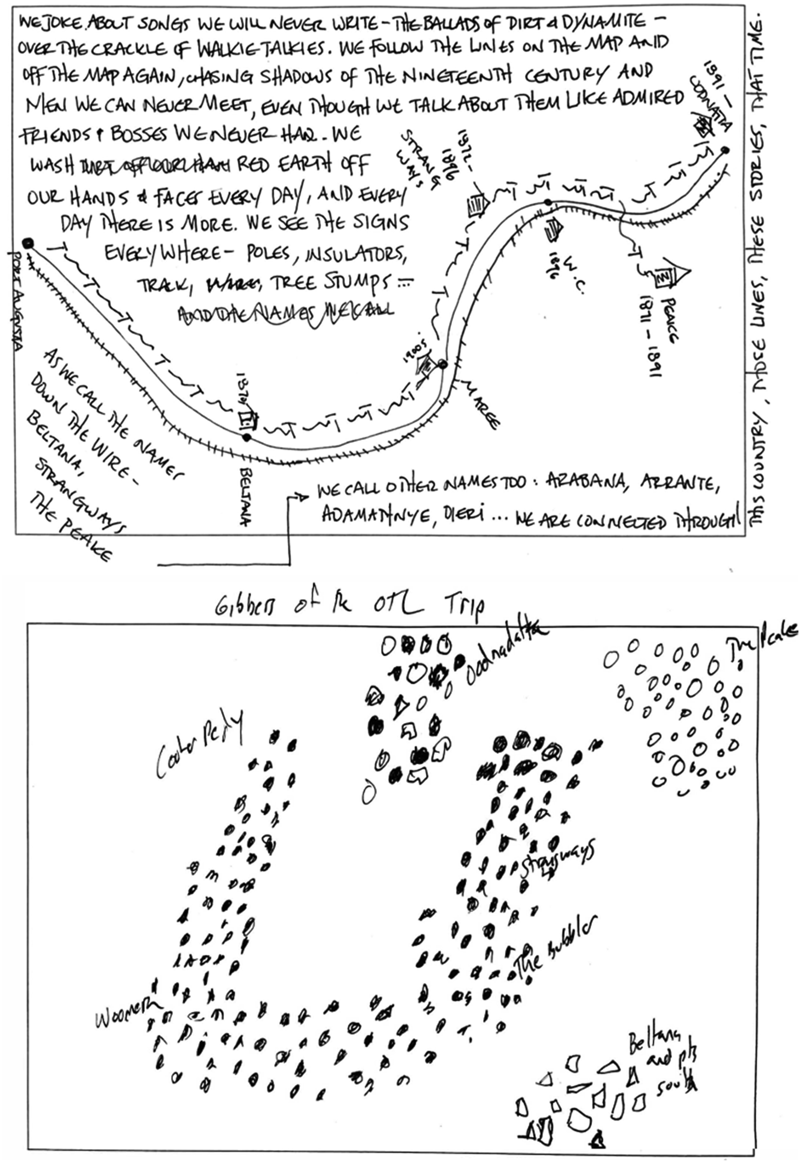
These activities empower us to be physically present, self-aware and better understand the relationships between historical technologies, the natural environment, and past identities in Australia. Every exercise is completed on a different day, in a different location, to optimize diversity in responses and inspire fresh perspectives on the artefacts and nodes of Australia’s telegraphy systems. Additionally, through the process of sharing our individual approaches to the exercises with each other, we move towards becoming ‘fully reflexive’ as our responses are ‘explicitly turned on the knower, who becomes self-conscious even of the reflexive process of knowing’ (Davies, 2008: 7). At this point, we are encouraged to ‘reflect on our own subjectivities, and then reflect upon the reflection in an infinitude of self-reflexive iterations’ (Gergen and Gergen, 1991: 77). In other words, we create a reflexive feedback loop.
Alongside reflexive ethnography, our in-field exercises could also be described as a form of embodied research (Leigh and Brown, 2021; Spatz, 2017; Thanem and Knights, 2019) where we explore the emotions, sensations, and lived experiences of us as researchers and the researched (telegraph workers, surveyors, repeater stations, railway lines etc.). From this perspective, each exercise [E]ngages the body in some way, whether we are observing others by looking, interviewing others by listening and talking, or seeking to share their worlds by touching the artefacts that occupy their surroundings, tasting the food they eat and absorbing the smells filling their spaces. (Thanem and Knights, 2019: 7)
This method encourages us to reflect on the social and physical implications of the OTL system, beyond its technological aspects. Indeed, ‘[e]mbodied research puts the focus on the body rather than on technologies. It does not exclude technology, but its spotlight is on embodied rather than technological possibilities’ (Spatz, 2017: 6). Our exercises involving poetry, physical artefact collection and colour observation, and photography that captures how we feel about a particular fieldwork moment or elements that have surprised us are especially relevant here.
Our reflexive cybernetics approach outlined in this section offers a new angle to understand the OTL that acknowledges the importance of situated practice and the unique background of each researcher. When used in conjunction with archaeology and visual cybernetics, it can help us move towards a more comprehensive and critical interpretation of large-scale complex systems.
Conclusion
In this paper, we have explored the OTL as a circulatory infrastructure through combining various archaeological, cybernetic, and reflexive practices. By following the flows of the OTL — the material, the archival, the decommissioning, the repurposing, and the corridors of connection that remain — we have provided a novel way to encounter a large-scale, historic socio-technical system, and make visible its workings and its enduring impacts.
Typically, the approach taken in archaeology would be to identify the physical traces of the system and attempt to classify the remains in some fashion, as seen with archaeological projects dealing with infrastructure at a landscape level, such as transport corridors (Ruiz, 2016).While our previous work has involved collaborative work with Aboriginal communities along the Line (e.g. Paterson, 2008), future work in Australia would require closer work with the relevant First Nations communities in order to develop and refine new approaches. This also requires determining the location of sites, assessing their integrity, and then using this to inform policy and conservation. A historical approach would similarly locate evidence for the telegraph, particularly in archives and libraries, before moving to consider the sites themselves (although this physical engagement may not always be possible or desirable). Our multi-methods approach can be applied to archaeology more broadly, but is especially useful in the archaeology of linear features, such as pathways, journeyscapes, Songlines, and linear infrastructure. We see this interest in ‘linear heritage’ as bridging the concerns of often separated realms of inquiry, particularly historical/industrial archaeology and indigenous archaeology, but also histories of technology and colonialism.
We have attempted here to suggest a richer process which unifies different ‘traditional’ disciplinary approaches to the telegraph system and reassembles them in new ways to generate a method suited to the challenge posed by cybernetics, to unify the technical and social dimensions of past infrastructure. This information will help better guide heritage policy, but also better reveal the relevance of the past for our understanding of other past and future systems in Australia.
Footnotes
Funding
The authors received no financial support for the research, authorship, and/or publication of this article.
Declaration of conflicting interests
The authors declared no potential conflicts of interest with respect to the research, authorship, and/or publication of this article.
Author biographies