
Abstract
Many communities in southwestern Madagascar rely on a mix of foraging, fishing, farming, and herding, with cattle central to local cultures, rituals, and intergenerational wealth transfer. Today these livelihoods are critically threatened by the intensifying effects of climate change and biodiversity loss. Improved understanding of ancient community-environment dynamics can help identify pathways to livelihood sustainability. Multidisciplinary approaches have great potential to improve our understanding of human-environment interactions across spatio-temporal scales. We combine archaeological survey data, oral history interviews, and high-resolution multispectral PlanetScope imagery to explore 400 years of human-environment interaction in the Namonte Basin. Our analysis reveals that settlement and land-use led to significant changes in the region’s ecology, both during periods of occupation and after settlement abandonment. Human activity over this period may have stabilized vegetative systems, whereby seasonal changes in vegetative health were reduced compared to surrounding locations. These ecological legacies may have buffered communities against unpredictable climate challenges.
Keywords
Introduction
The rural, less-developed landscapes that urban people tend to perceive as “natural” are often anthropogenic in ways that defy easy observation. Landscapes co-evolve with their human inhabitants, so that histories of adaptive decision-making are reflected in various dimensions of ecosystem composition, function, and health, including plant community structure, soil properties, and biogeochemical cycles. Scholars have offered different theories and frameworks to describe and explain historical landscapes, including complex socio-ecological systems (Bliege Bird, 2016; Lansing, 2003; Orr et al., 2015), the anthropocene (Lewis and Maslin, 2015; Steffen et al., 2011), and cultural niche construction (Odling-Smee et al., 2003, 2013), where cultural niches are also socially-constituted “places,” home sites rich with memory and meaning (Cresswell, 2004; Kieth and Pile, 1993).
The people who live in purportedly “natural” ecosystems, often communities that produce the majority of their own food, are critically vulnerable to climate threats (Intergovernmental Panel on Climate Change, 2022; Mugambiwa and Tirivangasi, 2017; Teh et al., 2013). Nearly a billion people, especially those living in marginalized and under-resourced areas, are grappling with the acute impacts of climate change, including food, water, and energy insecurity (Intergovernmental Panel on Climate Change, 2022).
As the climate crisis intensifies, longstanding assumptions about resource use (e.g., “Tragedy of the Commons”: Hardin, 1968) need to be reevaluated. This is particularly critical in regions with formerly colonized nations, where governmental policies frequently assume that traditional economies are inherently unsustainable under deteriorating environmental and socioeconomic conditions (e.g., African Union, 2013; Kull, 2000; Scales, 2012). In these contexts, land- and resource-use policies are often predicated on erroneous assumptions about past land-uses and landscape impacts, particularly that humans inevitably over-exploit common property resources and destroy nature. Meanwhile, investigations into the landscapes themselves offer alternative perspectives, revealing histories of previous resource management strategies interwoven with the making of place. Insights provided by records of multigenerational practices can aid conservationists in developing effective strategies geared towards local-scale resilience and sustainability (Berkes et al., 2000; Langley, 2006).
In this article, we use archaeological and remotely sensed data in combination with oral histories to explore the ecological legacy of human habitation and land-use in the Mikea Forest National Park in Madagascar. Since the park’s founding a decade ago, efforts toward environmental conservation have focused on regulating or banning many human activities, viewing them as destructive external forces on an otherwise “natural” ecosystem (Huff, 2012; Razanatsoa et al., 2021). To examine this perspective in greater detail, we focus on evidence for agropastoralism in the Namonte Basin portion of the park during the past four centuries, practiced among the ancestors of today’s Mikea people, who are well-known as hunter-gatherers but whose oral histories recount a rich history in cattle-herding and agropastoralism (Yount et al., 2001).
The Mikea Forest National Park in Madagascar’s semi-arid southwest was founded in 2012 to protect endangered dry forest ecosystems, including human inhabitants. The World Bank, a major funder supporting the creation of the park, classified the Mikea people as Indigenous and deserving of special protection (Huff, 2012). Park policies are predicated on the assumption that Mikea are hunter-gatherers, defined as “groups of individuals living essentially from wild tubers, honey, and wild animals” (Repoblikan’i Madagasikara, 2010: 22). Park rules exclude non-Mikea from living in the park, while Mikea are permitted to live within designated “controlled occupation zones.” Mikea have use-rights within designated “controlled utilization zones,” but, because Mikea are thought to be hunter-gatherers living in nature rather than farmer-herders in a domesticated landscape, these rights do not extend to clearing new farmland and pasture (Razanatsoa et al., 2021). Mikea people proudly self-identify as hunter-gatherers, yet they also recall ancestors who were wealthy in cattle and who combined farming with foraging. Given that Mikea have a long agropastoral heritage, the “natural” landscapes that the Park seeks to protect may be a product of the very activities the Park currently limits.
Mikea oral historians recall that their ancestors were once farmers and herders, but that they transitioned to foraging and forest life to escape the violent raids and tribute demands of the Andrevola kings who ruled the region until French forces conquered them in 1898 (Tucker, 2004; Yount et al., 2001). It is unclear when and how this transition occurred, and particularly, whether early Mikea continued or abandoned past agro-pastoral lifeways upon migration.
The question of whether early Mikea continued or abandoned agropastoralism within their forest residence is significant for understanding the co-evolution of Mikea cultural adaptations and landscapes. Stewardian human ecologists argued that agropastoral populations adapt to insecurities by developing complex corporate kin structures that consolidate, control, and bequeath land and livestock, while hunter-gatherer populations adapt to unpredictable, wild resources through flexible group membership, egalitarianism, mobility, and food sharing (Netting, 1977; Lee and DeVore, 1968; Isaac, 1990). Following this argument suggests that a population that moves from grassy savanna to dry forests and lakebeds would abandon patrilineal clans and private property norms as they increase dependence on wild resources. More recent cultural evolutionary models suggest that humans adapt to stress by forming social groups that cooperate to resolve potential collective action problems (Boyd and Richerson, 2010; Chudek and Henrich, 2011). These groups are argued to form around shared norms, some of which mark inclusion in the group (e.g., through ceramic styles and other expressions). Other norms dictate social and economic behavior (e.g., norms of fairness) by rewarding conformity and punishing transgressions. This model predicts that as early Mikea became more reliant on foraging, they maintained agropastoral social institutions such as patrilineal clans, as well as the cattle themselves.
Several authors have offered niche construction as a model to explain how pastoralist practices (e.g., the sustained presence of livestock) can cause long-term landscape transformations. Pastoral landscapes are characterized by changes in vegetation, likely resulting from the high nutrient content of dung deposits and the effects of grazing (Bogaard et al., 2013; Klehm et al., 2019; Marshall et al., 2018; McClure, 2015). In the Namonte Basin case, the use of livestock dung as topsoil, fertilizer, and compost would have aided in soil productivity for cultivation and agriculture, which the Mikea and their neighbors also practiced at different times (Andriarimalala et al., 2013; Rajaonahy et al., 2016; Rakotoarisoa et al., 2020). Negative feedback is also possible as overgrazing can lead to soil erosion and degradation of native vegetation.
Niche construction is also a cultural phenomenon, as humans transform geographic spaces into social “places,” where “place” refers to the sensorial experiences, memories, meanings, and social institutions embedded in space (Keith and Pile, 1993; Cresswell, 2004). Common themes in Malagasy placemaking are expansion of kin groups, migration into new spaces, the discovery of new place-specific taboos (fady or faly) required by resident ancestors and spirits, and the founding of new village and tomb sites (Keller, 2008; Osterhoudt, 2010). These are also major themes in Mikea oral histories discussed herein.
In this article, we address the question of when Mikea migrations occurred, using radiocarbon dates from archaeological contexts. We ask how the transitions to forest-based livelihoods occurred, discussing the possible role of herding and farming in early subsistence strategies, using oral histories and remotely sensed data. We use high resolution, multispectral satellite images to investigate the environmental signatures of ancient Mikea villages occupied between 100 and 400 years ago. We then compare these profiles to the surrounding landscape where there is no evidence of permanent occupations.
To locate archaeological sites in remotely sensed image data, we are ultimately trying to quantify and discern the human cultural niche (e.g., Odling-Smee et al., 2013; also see Jones et al., 2010) —i.e., non-random anthropogenic modifications to components of the environment like cattle pens and distinct vegetative signatures. By identifying these forms of cultural niche construction—and the signatures they produce in geophysical data (e.g., shape, electromagnetic reflectance, 2D and 3D profiles, etc.)—we can identify archaeological areas and infer important information about human-environmental relationships (Davis and Douglass, 2021).
Finally, we compare geophysical reflectance signatures and vegetative indices with extant paleoecological records from the Namonte Lake that document mineralogical changes in the Namonte region over the past several hundred years (see Domic et al., 2021). We hypothesize that if pastoralism was a predominant practice we would find the following results: 1. key nutrients associated with dung and herding contexts (e.g., N, P, K, Ca, S, Fe, etc.) should be present in elevated levels compared to surrounding landscapes; 2. electromagnetic reflectance values (Green, Red, and NIR wavelengths) will be statistically distinct between archaeological villages and the surrounding region resulting from changes to soil composition and vegetative characteristics (Ben-Dor, 2011; Ge and Thomasson, 2006; Sripada et al., 2006; Thabeng et al., 2019; Thomasson et al., 2001); and 3. these changes in soil ecology would alter vegetation characteristics by: (a) modifying vegetative health and productivity; (b) introducing new taxa with different properties than surrounding landscapes; and/or (c) modifying the seasonal stability of vegetation.
To address these hypotheses, we use vegetation indices to determine the impacts of soil properties on plant taxa. Overall, we aim to address the legacy effects of land-use practices associated with semi-sedentary pastoralist villages over the last 400 years on modern soil and vegetation systems (Figure 1). Map of the Namonte Basin and all archaeological village sites analyzed within the study. These sites were recorded during surveys in 2018. Other locations mentioned in the text are numbered: 1. Andamotiabo; 2. Ankilitelo; 3. Antanimena; 4. Bebokaky; 5. Vondrobe. Service Layer Credits: ESRI, DigitalGlobe, GeoEye, Earthstar Geographics, CNES/Airbus DS, USDA, USGS, AeroGRID, IGN, and the GIS User Community.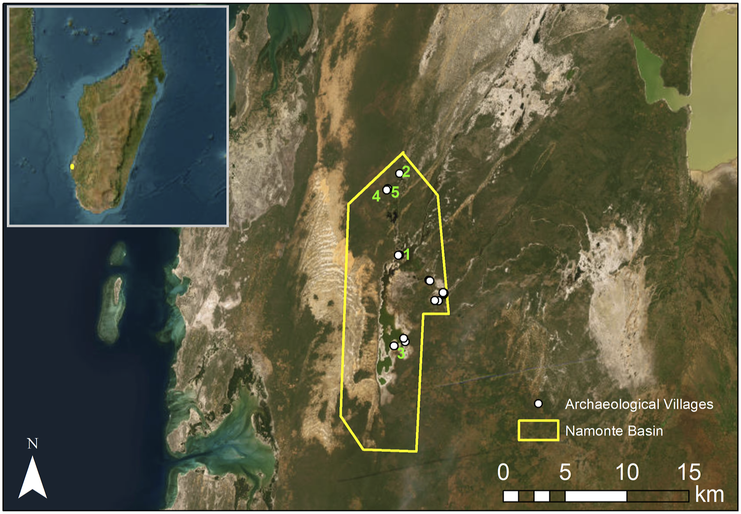
Background
Southwest Madagascar is an ideal site to investigate cultural niche construction and placemaking due to its long history of climatic and ecological variability, a record of known novel disturbances (e.g., extreme shifts in climate, faunal extinctions and introductions), and archaeological, ethnohistorical, and ethnographic evidence of diverse communities shifting flexibly between livelihood strategies. One of the most arid regions of Madagascar, the SW is characterized by a highly unpredictable climate and the highest levels of floral and faunal endemism on the island (Dewar and Richard, 2007; Jasper and Gardner, 2015). The region is also recognized for its high density of fossil extinct megafauna, suggesting it has long been a biodiversity and endemicity hotspot that has experienced significant ecological shifts over the course of human settlement in the Late Holocene (e.g., Federman et al., 2016). Part of the Mikea Forest was designated a National Park in 2012, as an effort towards nature conservation (Goodman et al., 2018). Conservation policies in Mikea National Park have been criticized, however, for disregarding Mikea communities’ needs and placing limitations on livelihood strategies (Huff, 2012; Razanatsoa et al., 2021; Tucker, 2020).
The Malagasy people who live in and around the Mikea Forest (Agnalamikea) self-identify as Mikea, Masikoro-Mikea, or Vezo-Mikea. Astuti (1995) has argued that among coastal Malagasy people living roughly 150 km north of the Namonte Basin, ethnicity is occupation, so that the more one fishes, the more one becomes Vezo, and farming makes one Masikoro. Although Mikea, Masikoro, and Vezo in our research zone consistently emphasize the links between occupation and ethnicity (as if Mikea = forager, Masikoro = farmer, Vezo = fisher), we have found that people self-identify ethnically for a variety of occupational and historical reasons, often inconsistently with their occupational categories, and that most household economies are to some degree diversified. Elsewhere, two of us (BT, T) have argued that purported ethnic occupational specializations are symbolic and related to the stories told of significant ancestors. Farming and herding symbolize the permanence and pride of being vassal to the Andrevola kings (making one Masikoro); foraging symbolizes evading kings by hiding in the forest (making one Mikea); and fishing and sailing symbolize freedom from kings won by sailing away to sea (making one Vezo) (Tucker et al., in review). Mikea individuals often take pride in their hunting and gathering skills. Simultaneously, Mikea venerate recent ancestors who were wealthy in cattle and did some cultivation, accumulating wealth that they hid from outsiders (Kelly et al., 2005; Tucker, 2004; Tucker et al., 2010; Yount et al., 2001).
Radiocarbon dates acquired from archaeological villages in the Namonte Basin.
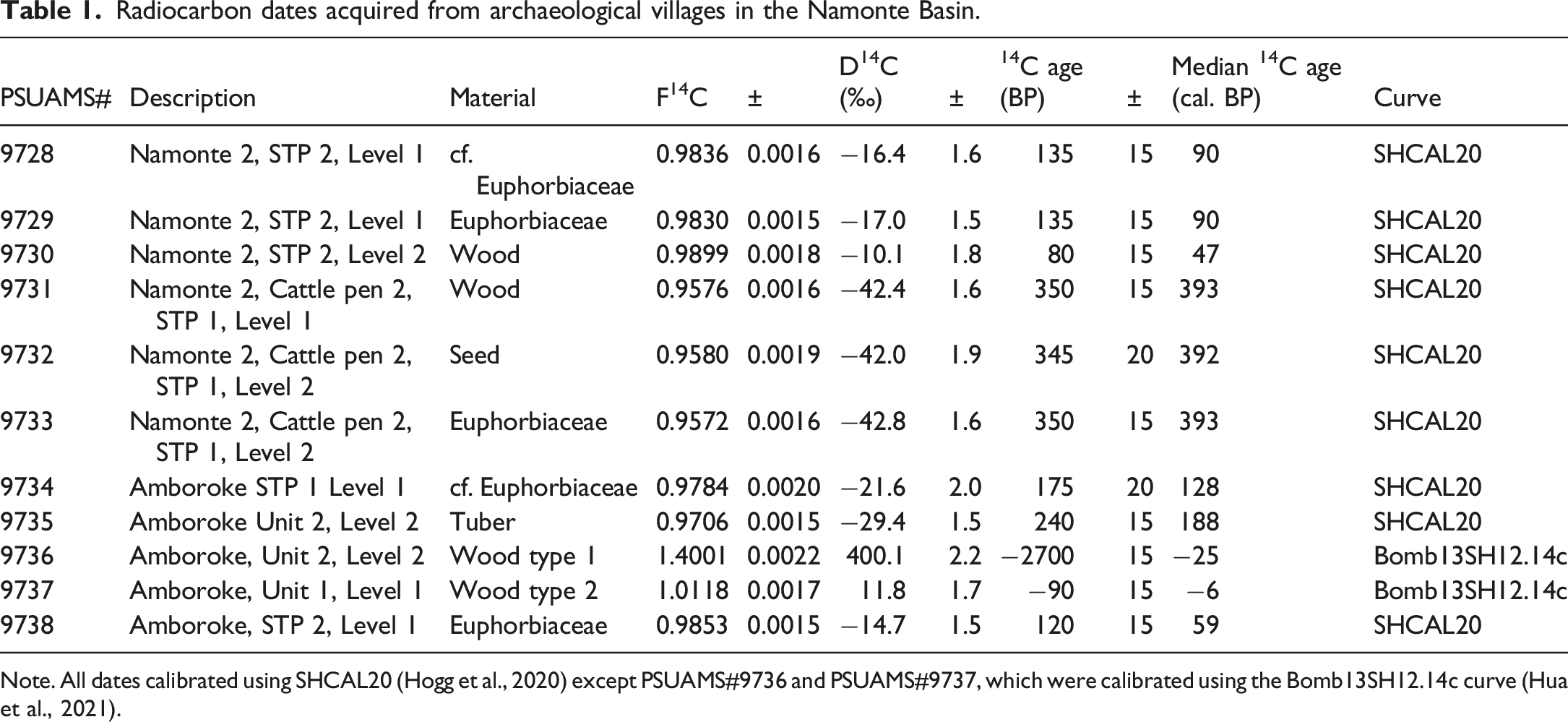
Note. All dates calibrated using SHCAL20 (Hogg et al., 2020) except PSUAMS#9736 and PSUAMS#9737, which were calibrated using the Bomb13SH12.14c curve (Hua et al., 2021).
Methods
In 2018, we conducted semi-structured oral history interviews and archaeological surveys in the Namonte Basin of SW Madagascar. Local historians, typically community elders, were asked about the location of ancient villages and accompanied the field team to sites they knew. At each site, the field team then split into two groups, with part of the team working with Mikea elders to document histories pertaining to the sites (led by BT and T) and the other part of the team conducting surface survey and shovel test pits (KD and MAP team). After establishing informed consent,
1
interviews were audio recorded and handwritten notes were taken. We conducted archaeological surveys in north-south transects spaced approximately every five meters until surface artifact scatters were no longer present. In addition, elders were asked to help identify and locate site features, including ritual posts, remains of houses, and cattle pens (Figure 2). Diagnostic artifacts, such as decorated ceramic sherds and beads, were collected when present. We conducted small shovel test pits of 25 cm × 25 cm in order to recover datable materials (e.g., charcoal) in features identified as cattle pens. We selected a total of 11 charcoal pieces recovered from five different sites for radiocarbon dating. Samples were photographed using a digital VHX-7000 Keyence microscope and taxonomically identified using a reference charcoal collection hosted at Columbia University and the Inside Wood Database.
2
Samples were selected based on preservation, species identification, and life-cycle (long- vs short-lived). We then prepared the charcoal for AMS analysis by pretreating all selected samples using an acid-base-acid (ABA) decontamination protocol to remove humates. ABA consisted of washes with 1N HCl and 1N NaOH for 20-min intervals at 70°C. Pretreatment and graphitization were conducted in the PSU Stable Isotope Geochemistry Laboratory. AMS was conducted at Penn State’s Energy and Environmental Sustainability Laboratories Radiocarbon Facility and dates are reported using accepted standards (Stuiver and Polach, 1977). We conducted AMS calibrations using the SHCAL20 calibration curve (Hogg et al., 2020). A more detailed report and analysis of archaeological and oral history data are provided in a separate forthcoming publication. Dark stains in the soil identified by Mikea informants as the sites of historic cattle pens (valan’aomby). Photo by Bram Tucker.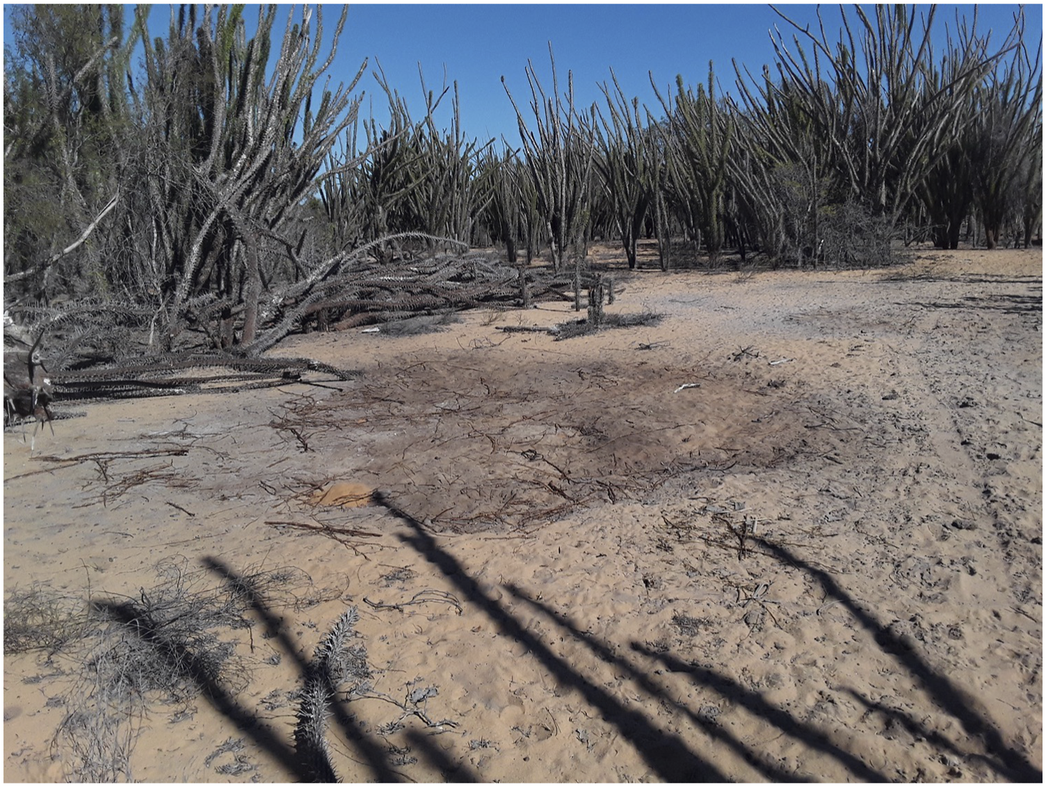
Here, we focus on using high-resolution, multispectral PlanetScope satellite images to investigate spatial relationships between plants, vegetation, and ancient Mikea villages occupied between 100 and 400 years ago. We then compare these profiles to the surrounding landscape where we have no evidence of permanent occupations. Finally, we compare geophysical reflectance characteristics (captured by the satellite images) with paleoecological records from a lakebed in the Namonte Basin that document a millennium of changes in land-use and environmental conditions, via shifts in the presence and abundance of terrestrial and aquatic taxa (see Domic et al., 2021).
Although Mikea and their neighbors recognize four distinct seasons distinguished by rainfall and temperature, 3 we contrast geophysical reflectance between the wet monsoon season (November–April) and the dry season (May–October). Because the landscape drastically changes between these periods, multitemporal analysis is needed to assess the impacts of human activity during both seasons (e.g., Alders et al., 2024). We use multispectral PlanetScope (Planet Team, 2020) satellite images to identify signatures of 16 identified archaeological village sites located in the Namonte Basin. PlanetScope data has four electromagnetic bands (Blue, Green, Red, and Near Infrared [NIR]) with 3 m spatial resolution and is freely available to researchers. These data have proven useful for archaeological analysis in neighboring regions of Madagascar and other Indian Ocean islands (see Alders et al., 2024; Davis and Douglass, 2021). Specifically, we use data taken from June of 2020 (representing the early/middle dry season) and February of 2021 (representing the middle of the wet season) to evaluate the capacity for multispectral imagery to reveal legacies of human land and resource use in the Namonte Basin (∼170 km2; Supplemental Table 1). Images from each season were mosaiced in R (R Core Team, 2020) using the raster package (Hijmans, 2019) for analysis (Supplemental File).
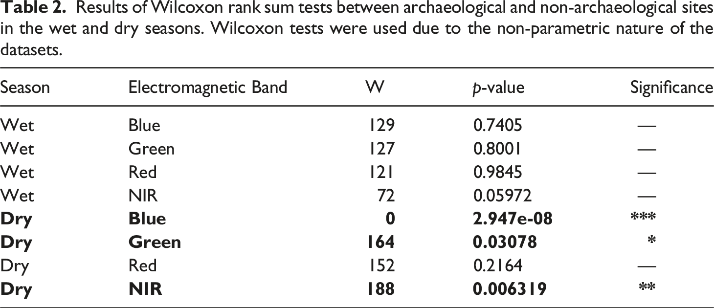
To compare geophysical signatures between archaeological villages (n = 16) and non-archaeological areas (n = 15), we use statistical independence tests to determine if the two datasets are statistically different for each electromagnetic band (Blue, Green, Red, NIR). The amount of light reflected or absorbed in different bands tells us about environmental characteristics on the ground (e.g., higher Green and NIR reflectance signifies the presence of healthy vegetation). Tests are conducted for each season, separately, to evaluate if climatic shifts across the year influence the visibility. We first test the data using the Shapiro-Wilk test to determine whether parametric or non-parametric statistical assessment is warranted and find that the data are not normally distributed (p > .05; see Supplemental File). Therefore, we use non-parametric statistical assessments (Wilcoxon Rank Sum Tests) for our analysis. All evaluations are conducted in R (R Core Team, 2020). If statistical independence tests demonstrate a significant difference between the group of archaeological villages and the group of non-archaeological localities on the basis of geophysical signatures, we can interpret this as an indicator of anthropogenic landscape modification (e.g., Laland and O’Brien, 2010; Odling-Smee et al., 2003).
We can further assess the duration of this effect by comparing these results with existing paleoecological data from Namonte Lake (located in the center of the study region), which provides a 1000-years record of ecosystem shifts that are attributed to land-use change (Domic et al., 2021). If radiocarbon dates from archaeological sites in this region align with the Namonte Lake record, we can establish a relationship between human occupations and changes to environmental conditions like soil and vegetation. Furthermore, long-term records of geochemical changes in soil content can be correlated with geophysical reflectance signatures recorded in satellite imagery. In particular, we hypothesize that if there are elevated levels of nutrients like K and Ca (which are commonly found in elevated levels from dung deposits) at archaeological sites, reflectance values should be higher than surrounding areas in the Green and Near Infrared (NIR) spectra (see Ben-Dor, 2011; Bogrekci and Lee, 2005; Thabeng et al., 2019, 2020; Thomasson et al., 2001). This can help us to extrapolate about long-term human-environment relationships from modern satellite observations.
Next, we use the normalized difference vegetative index (NDVI) to assess the relationship between historic residency and land-use and contemporary vegetation characteristics. NDVI is a standard metric of vegetative health and biomass (Jensen, 2007) and has been effectively utilized on Madagascar (Davis and Douglass, 2021; Phelps et al., 2022). We compare the NDVI profiles of archaeological settlements and non-archaeological areas using the same procedure detailed above and quantify the degree of seasonal vegetative change associated with these zones. We compare ranges of NDVI shift between the wet and dry seasons to examine whether vegetation is more or less stable around archaeological settlements compared with non-anthropogenic areas today. This is important for evaluating claims about the impacts of pastoral lifeways on contemporary ecological conditions.
Results
Oral histories
We added the seven new oral histories collected for this study to an existing set of 60 interviews collected by authors T and BT since 1996 (Tsiazonera and Tucker, in review; Tucker et al., in review; see also Douglass and Rasolondrainy, 2021).
In southwestern Madagascar, oral histories accompany the genealogies that elders recite at ceremonies when venerating ancestors. Ancestors’ names are public information for all who attend ceremonies, so that while clan elders are the primary historians, ancestors’ names and deeds are known by the populace.
The earliest stories we have collected tell of events that caused famous Mikea ancestors to leave the agropastoral world and start a new life in the forest. A major theme in these stories is resistance to the authority and abuses of the Andrevola kings.
In the contemporary Namonte Basin village of Ankilitelo, located in one of the Park’s Controlled Occupation Zones, we heard stories about founders from the Tohaombe clan. Descendants of brothers Retolake and Repaike and their sister Ampelamalaza, the Tohaombe have long occupied the tidal flats on the south end of the Bay of Fagnemotse (Bay of Assassins) where they were rich in cattle. During “the time of the kings” (tamin’ny mpanjaka, the 17th–19th centuries), the Tohaombe attracted the attention of the kings’ soldiers, who demanded tribute in cattle, and took cattle by force. To avoid these abuses, Tohaombe operated remote pasture territories (toets’aombe) in the Namonte Basin, a landscape that offered water and forage but that was insulated from the outside world by dense forest and towering dunes. At first these toets’aombe were sparsely populated satellite communities, but as royal abuses accelerated, they absorbed more migrants and became villages.
Contemporary Tohaombe led us to the sites of the precolonial villages of Andamotiabo and Vondrobe, and the 20th-century village of Bebokaky. They pointed out komba, stones placed in the corners of the old house sites of venerated ancestors, and also cattle pens (valan'aombe), roughly rectangular dark patches of soil.
Cattle pens are a point of pride for southwestern Malagasy people, as they symbolize wealth. For example, a contemporary Masikoro village on the eastern edge of the Mikea Forest bears the name Antaimbalabo, meaning “place (an-) where the manure (-tai-) in the pens (-vala-) is high (-abo).” Likewise, our Mikea informants were proud of the darkly stained soil showing the wealth of their ancestors.
A Tohaombe elder provided a particularly vivid account of what life was like at Vondrobe during the time of the kings. To hide from the king’s slave raiders, the people of Vondrobe chose to cut themselves off from the world entirely. They kept cattle and goats but not chickens, for fear that the noise chickens make would betray their presence. They lived off wild tubers and lake products plus some cultivated food. On the rare occasions when they left Vondrobe, they were careful not to pass the same way twice, to avoid making visible trails that others could follow.
At the contemporary Namonte village of Antanimena, also in the Park’s Controlled Occupation Zones, informants from the Marofote clan repeated a story we (BT, T) have heard repeatedly since our first visits to the region in the 1990s. During the time of the kings, a Marofote man named Redihany lived in the Manombo River valley, which was then the core of the Andrevola domain. After harassment by the king's slave raiders, Redihany and his wife Tsimivandry fled into the dense Mikea Forest, without their livestock. There, they lived for a year as nomads, surviving on wild foods. Eventually they found their way to a place called Andranotsiritse (or Andranosoritse), at the very southern tip of the Namonte Basin. There, they met other refugees, including people from the Ndrambalà and Vazay clans.
When Vazay people in Namonte venerate ancestors, they begin with a man named Bevolo (“big hair”). Like Redihany, Bevolo and his wife had lived in the Manombo River Valley. The king at the time demanded to be able to sleep with Bevolo’s wife; to evade this threat, Bevolo, his wife, and their cattle escaped into the forest, eventually settling in Namonte.
The descendants of Redihany, Bevolo, and others formed the village of Amboroke, the remains of which informants led us to in 2018. Here, as at Andamotiabo and Vondrobe, they proudly showed komba stones that marked the corners of celebrated people’s houses, and the dark rectangles of soil that demonstrated their ancestors' cattle wealth. As the stories go, Redihany and Bevolo both eventually gained up to 200 head of cattle. Hunting and gathering remained a major part of their subsistence life, but stories are replete with mentions of livestock, and also mention manioc, sweet potatoes, maize, and rice.
In the contemporary villages of Ankilimiavotse and Ampijilova we collected stories from members of the Tsimitiha clan, who claim to be founders of a series of villages, each named “Namonte” during its time. Our Tsimitiha informants are less clear about their origins. One source said that, like the Marofote and Vazay, they originated in the Manombo River Valley. Chased for many years by the king’s soldiers and slavers (mpangala’olo), the Tsimitiha eventually ambushed the soldiers and beheaded their captain. Some time later they settled in Namonte and began accruing livestock.
Tsimitiha oral historians tend to emphasize more recent ancestors. Mampalè was a diviner (ombiasa) who was so powerful that after his death he was renamed Ramaromatahotse, “he who is feared by many.” Mampalè’s wife, Tsijefany, was equally famous for her magical power, the source of which was a forest spirit that possessed her in trance ceremonies. Among their children was Tsiasinda, who is regarded as far away as Toliara as the greatest Mikea diviner of the 20th century (he died in 1986). These three figures used their magic to protect Mikea from exploitation by outsiders—the Andrevola during Mampalè and Tsijefany’s time, and the French during Tsiasinda’s life. They could teleport tamarind trees, hide villages, and confuse invaders (for more details, see Tsiazonera and Tucker, in review).
Radiocarbon analysis and paleoecology
The 11 radiocarbon dates from five sites indicate permanent human occupation from at least the last 300–450 years (Table 1). Based on the distribution of the dates, settlement occurs in two distinct stages around 300-400 BP and 200 BP to the present. The dated archaeological features correspond with villages described in the oral history interviews. All of these villages had cattle pens, which suggest prolonged agropastoralist activity. The timing of the occupation of these villages corresponds with significant environmental and climatic change recorded in previously published sediment cores from Namonte Lake (Figure 3; Domic et al., 2021). XRF Measurements for Fe, Ca, and K (black lines) from the Namonte Lake Sediment Core recorded by Domic et al. (2021). These geochemical profiles indicate mineralogical changes to the ecology of Namonte which correspond with geophysical data presented in this article. Code to create figure provided in Supplemental File.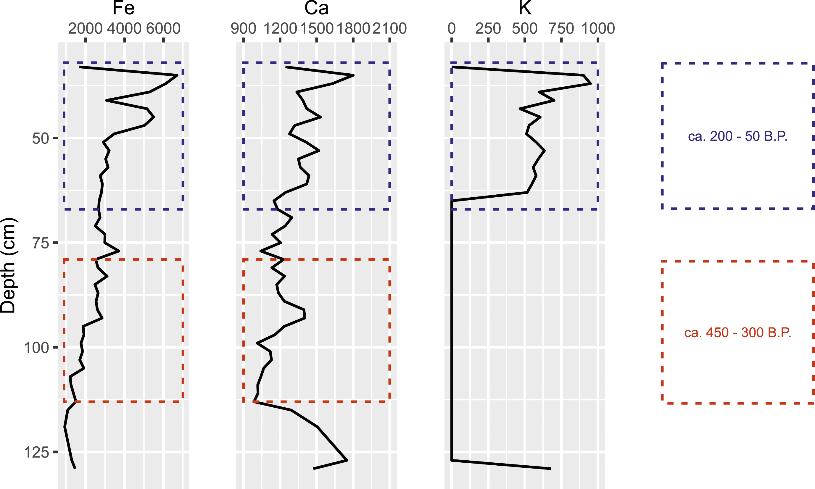
When observing lake core sediment data we see an increase in Ca and Fe levels beginning at 110 cm in depth (ca. ∼450 cal. BP; Figure 3). This lines up in time with the introduction of cattle, as inferred by the earliest dates for the use of cattle pens in and around ancient villages in the Namonte Basin (Table 1). Subsequently, sediment cores show a spike in K levels that begins around 65 cm, corresponding with a second phase of human occupation ca. 200 cal. BP. K, in particular, is often found in higher concentrations in areas that are fertilized, which aligns with evidence of pastoralist communities occupying these areas.
Remote sensing analysis
Results of Wilcoxon rank sum tests between archaeological and non-archaeological sites in the wet and dry seasons. Wilcoxon tests were used due to the non-parametric nature of the datasets.
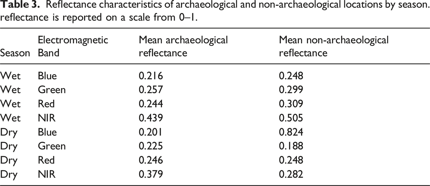
Reflectance characteristics of archaeological and non-archaeological locations by season. reflectance is reported on a scale from 0–1.
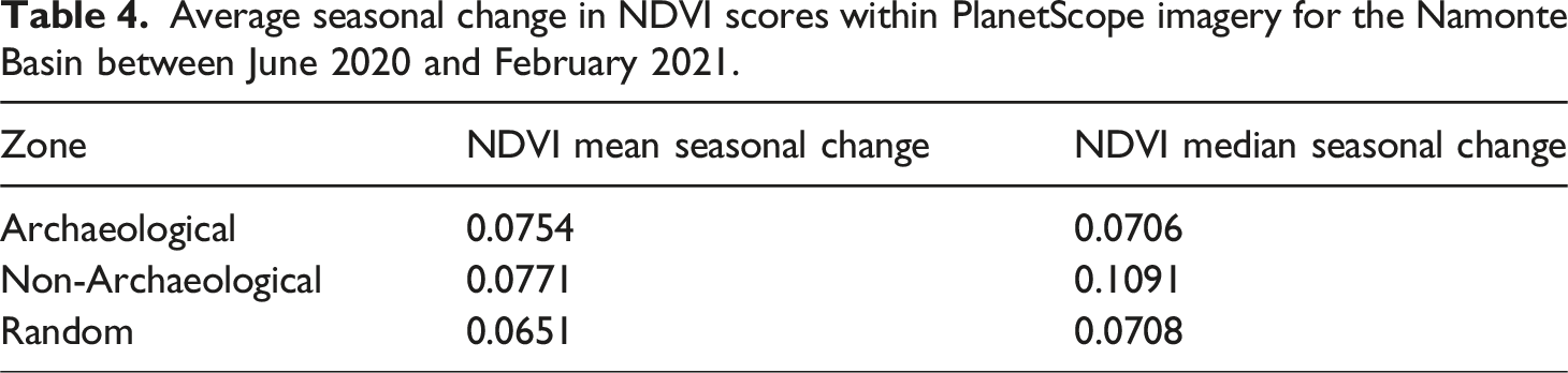
NDVI signatures show sustained differences between archaeological and non-archaeological (and random) locations in the dry season, but these differences are not statistically significant (Dry: W = 109, p = .9185; Wet: W = 111, p = .7405) (Figure 4). Data were non-normally distributed in the wet season but normal in the dry season, but the same result is obtained using parametric tests (Dry: t = 0.022669, df = 20.048, p = .9821; Wet: t = −0.062089, df = 22.77, p-value = .951). Furthermore, the average seasonal change between NDVI signatures on and around archaeological sites is smaller than the change on and around non-archaeological zones, signifying less change in vegetation health (Table 4). Random locations have the lowest mean change (but these areas may contain other anthropogenic components) and archaeological locations have the lowest median change. Mean NDVI values of archaeological, non-archaeological, and random locations throughout the Namonte Basin during the wet (February) and dry (June) seasons. Plot background colors correspond with NDVI values and relative vegetative productivity. Average seasonal change in NDVI scores within PlanetScope imagery for the Namonte Basin between June 2020 and February 2021.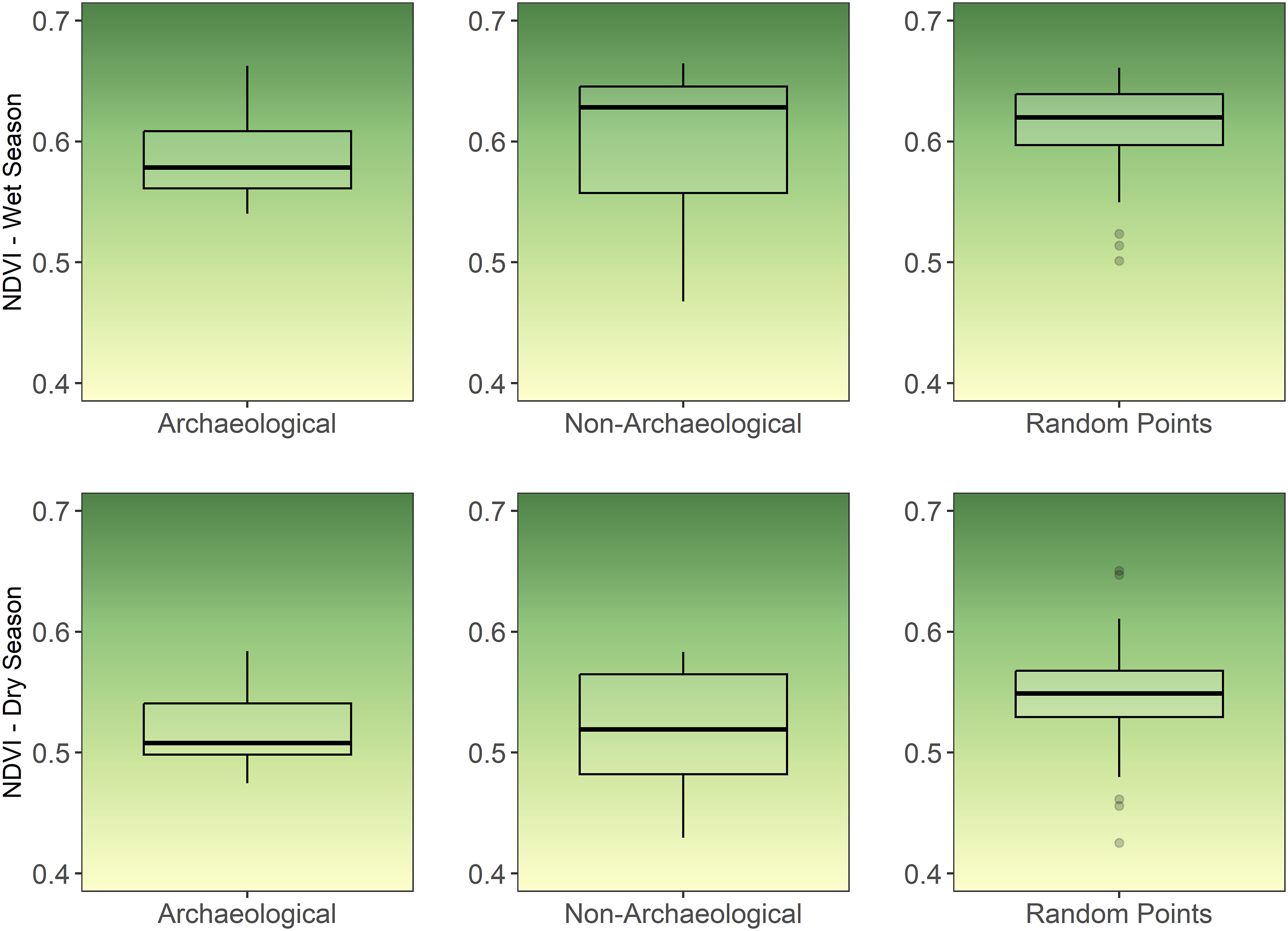
Discussion
Archaeological evidence in the form of cattle pen features, cattle bone assemblages, and associated charcoal materials demonstrate that communities have lived and herded cattle in the Namonte Basin for at least the last 450 years, consistent with oral accounts (Table 1). In this time, the landscape has changed considerably, as evidenced by sediment cores from Namonte Lake (Figure 3; Domic et al., 2021). Alongside our remote sensing analyses, we can find clear correlations between the kinds of mineralogical and chemical changes observed in lake sediment cores and reflectance characteristics recorded in satellite imagery. In addition, these paleoecological records line up with radiocarbon dates for the first instances of cattle pen usage and a shift in aquatic species inhabiting the lake (Table 1; Figure 3).
We hypothesized that if pastoralism was a predominant practice, key nutrients found in dung would be present in elevated levels. The increase in Ca and Fe levels beginning ca. ∼450 cal. BP (Figure 3) temporally coincides with the introduction of cattle, as inferred by the earliest dates for the use of cattle pens in and around ancient villages in the Namonte Basin (Table 1). Remote sensing data shows reflectance increases within archaeological areas in the Green and NIR spectra (Table 3), which can be partially explained by elevated levels of organic matter and minerals like Ca, Fe, and K in the soil (Ben-Dor, 2011; Bogrekci and Lee, 2005; Ge and Thomasson, 2006). Increases in K levels ca. 200 cal. BP may signify an increase in pastoralist community occupations, as K, in particular, is often found in higher concentrations in areas that are fertilized. Studies have demonstrated that archaeological soils with concentrations of Ca and other minerals are spectrally distinct from non-archaeological soils (Thabeng et al., 2019), and that spectrally, soils with concentrations of Ca, K, and other minerals are spectrally separable in the Green and Infrared spectra (Thomasson et al., 2001).
Together, these data suggest that ancient herding communities played a key role in modifying the dry forest landscape, as geophysical signatures of abandoned villages display significant differences in soil and vegetation characteristics compared with surrounding areas. Where there is evidence of pastoral practices (e.g., cattle pen features), we find elevated levels of soil nutrients and changes to vegetative characteristics, likely resulting from dung deposits and grazing effects (Bogaard et al., 2013; Klehm et al., 2019; McClure, 2015). Ongoing research does demonstrate differences in these characteristics across subsistence strategies but this goes beyond the scope of this paper (see Davis et al., in review). Overall, these findings reaffirm our hypotheses that geophysical signatures would be distinct between archaeological villages and the surrounding region and that vegetation could have been influenced by the introduction of new domestic animals into the region.
Furthermore, we find that human activities lower seasonal variation in vegetative productivity, thereby improving ecosystem function in the present (Table 4). These results are important when considering the long-term impacts of archaeological activities. While these metrics of ecosystem productivity are calculated using modern data (2018–2022), they reflect a historic trend in landscape characteristics that are the result of repeated human land-use over 400 years. The use of livestock dung as topsoil, fertilizer, and compost would have aided in soil productivity for cultivation and agriculture which Mikea and their neighbors also practiced at different times (Andriarimalala et al., 2013; Rajaonahy et al., 2016; Rakotoarisoa et al., 2020). This observation, coupled with evidence from paleoecology (Figure 3), shows that soil and vegetation have been impacted by the arrival of pastoralism ca. 400 BP, and the NDVI values demonstrate how these legacies feed into the contemporary state of this ecosystem. Interpretations of such results require the consultation of additional information to better understand centuries of human-environment interaction in this area.
For example, ethnographic and oral history data lend further insight into the patterns observed in remote sensing data. We know that in the Namonte Basin, people tend to remain close to the system of perennial lakes and stream channels (saha) during the dry season because these offer sources of water. During the wet season, however, they often herd their cattle deeper in the dry forest. Satellite observations show that the dry season displays higher reflectance values in the NIR and Green wavelengths and higher NDVI values, indicating increased vegetative health and moisture retention. During the wet season, some of the trends we see between archaeological villages and the surrounding landscape reverse, where the NIR spectrum shows lower reflectance at village sites but higher reflectance in nearby regions where grazing is likely taking place over time.
Altogether, the correlation between geophysical and geochemical evidence suggests that pastoralist communities occupying the Namonte Basin over the past several centuries have significantly altered the region’s ecology in ways that persist into the present. Significantly, remote sensing measurements provide evidence that seasonal climatic changes impact vegetation less within archaeological sites compared to locations outside of extensively occupied areas. This suggests that pastoralist practices (e.g., herding) may provide significant benefits to the landscape by stabilizing local vegetative and soil conditions, contributing to greater resilience of ecosystems in light of changing climatic conditions. This, in turn, likely caused feedbacks for other plant and animal species, which requires further research, but does offer exciting avenues for investigating the sustainability and resilience of pastoralist economies over the long term (also see Brierley et al., 2018; Ullah et al., 2019).
Conclusion
Despite their reputation as exotic hunter-gatherers, Mikea oral histories demonstrate similar placemaking themes as have been documented in other parts of Madagascar: the movement of famous ancestors, representing their clans, into new spaces, which are converted into “places” by the establishment of villages, tombs, and herds. What makes these stories uniquely Mikea are themes of political resistance and independence.
To outsiders, this telling of Mikea history may cause some categorical confusion: are Mikea really hunter-gatherers, if they and their ancestors are agropastoralists? This question, which we are accustomed to hearing from colleagues in hunter-gatherer studies, says more about Western philosophical baggage than it does Mikea lifeways. As Barnard (1999) has documented, the hunter-gatherer category emerged from Enlightenment-era social philosophy about the origins and functions of property and law. Thinkers like Hobbes and Rousseau invented the concept of “man in the state of nature” not from any real data about people, but as a hypothetical contrast to “civilized man,” who owned private property and had laws to protect it. Only later did explorers meet actual people who they shoehorned into the “natural” category, whether it fit them or not. The contemporary category of hunter-gatherer contains a diverse set of peoples and cultures (Kelly, 2013), many of whom have agropastoral roots and diversified economies (Blackburn, 1996; Solway and Lee, 1992; Wilmsen and Denbow, 1990).
Mikea people, few if any of whom have heard of Hobbes and Rousseau, define themselves as hunter-gatherers for their own reasons: because, to this day, they hunt and gather to meet a large part of their food needs, and because foraging symbolizes political resistance and independence. Unburdened with the European obsession over “man in the state of nature,” Mikea see no contradiction between hunting-and-gathering and owning livestock. Like many other Malagasy, cattle symbolize both wealth and the ancestral continuity of clans, and are a point of pride.
The Stewardian model of cultural adaptation predicts that as agropastoralists transition to foraging, property management becomes less of a challenge than seasonal and regional fluctuations in food supply, so that corporate descent groups decline in importance (Netting, 1977). This is not demonstrated in the Mikea case, where histories are structured around stories of clans and cattle wealth. Rather, consistent with cultural evolutionary models of social group formation (McElreath et al., 2003), Mikea maintained agropastoral norms and institutions because these mark group membership and identity, enhancing social cohesion.
Note that evidence that contemporary Mikea have agropastoral roots does not make them any less “Indigenous,” according to the World Bank’s definition (World Bank, 1991), consistent with the United Nations Declaration on the Rights of Indigenous Peoples (2008). 4 Most of the estimated 476 million Indigenous people are not hunter-gatherers, who may number 10 million (Burger and Fristoe 2018).
Overall, our study highlights the long-term co-evolutionary dynamics between pastoralists and their surrounding ecologies over the past four centuries using geophysical, geochemical, archaeological, and ethnographic data. We show how landscape modifications made by communities leave discernable traces on soil and vegetation that persist for hundreds of years, even when there are few-to-no topographic or structural elements remaining (also see Davis and Douglass, 2021). Furthermore, evidence provided here suggests that human activities may have increased the stability of vegetative systems. This runs counter to the traditional narrative surrounding Mikea communities, who are often blamed for ecological degradation of the Mikea Forest (Blanc-Pamard, 2009; Seddon et al., 2000; Waeber et al., 2015; World Bank and ONE, 2003; see discussion in Kull, 2000; Scales, 2012). As such, this finding warrants further investigation and may hold significant insight for rethinking the role of subsistence economies in developing land-use policies that sustain people and landscapes (Phelps et al., in review).
The presence of archaeological, paleoecological, and oral historic evidence for cattle herding, manuring, and farming suggests that Mikea have practiced farming and herding activities in the boundaries of the modern-day park since antiquity, and that the “natural” ecosystems the park seeks to protect may be anthropogenic in origin. Park planners should consider allowing the park’s Mikea residents to practice a wider range of agropastoral subsistence activities, including managed land clearing. If done carefully, increased farming and herding in the park could have win-win consequences, stabilizing ecological relationships and improving the livelihoods of Mikea communities (Razanatsoa et al., 2021).
Supplemental Material
Supplemental Material - Archaeology, ethnography, and geosciences reveal central role of traditional lifeways in shaping Madagascar’s dry forests
Supplemental Material for Archaeology, ethnography, and geosciences reveal central role of traditional lifeways in shaping Madagascar’s dry forests in Dylan S Davis, Bram Tucker, Tsiazonera, Ricky Justome, Zafy Maharesy Chrisostome, Briand Venance Pierre, Alejandra I Domic, Leanne N Phelps, Abiola Ibirogba, Chiamaka Mangut, Carla E Klehm and Kristina Douglass in Journal of Social Archaeology
Footnotes
Declaration of conflicting interests
The author(s) declared no potential conflicts of interest with respect to the research, authorship, and/or publication of this article.
Funding
The author(s) disclosed receipt of the following financial support for the research, authorship, and/or publication of this article: This research was supported by a National Science Foundation SBE Postdoctoral Fellowship Award (SMA-2203789), a Wenner-Gren Foundation Post PhD Research Grant, the NASA Pennsylvania Space Grant Consortium, the National Science Foundation (BCS-1733917), and a SPARC Award. The SPARC Program is based at CAST at the University of Arkansas and is funded by a generous grant from the National Science Foundation (Award #2012590). LNP was supported by the Swiss National Science Foundation (SNSF) [P500PN_206663; P2LAP2_187745].
Data availability statement
All code used to conduct analyses described in the manuscript is provided as supplemental files associated with this article. Archaeological site data (e.g., coordinates) are available upon reasonable request but cannot be publicly shared due to agreements with local communities and ethical concerns.
Supplemental Material
Supplemental material for this article is available online.
Notes
Author biographies
References
Supplementary Material
Please find the following supplemental material available below.
For Open Access articles published under a Creative Commons License, all supplemental material carries the same license as the article it is associated with.
For non-Open Access articles published, all supplemental material carries a non-exclusive license, and permission requests for re-use of supplemental material or any part of supplemental material shall be sent directly to the copyright owner as specified in the copyright notice associated with the article.