
Abstract
The value of maps in geographical and social-scientific research as tools that afford imaginative aesthetic engagement with research topics has become increasingly recognised. We explore here, for the first time, the value of these affordances for interviewing experts. In particular, the imaginative engagement maps can provide may help unsettle routines of thought, and invite reflexivity towards the assumptions on which expert knowledge may rest. This contribution of maps can be particularly valuable in research where anticipating potential future consequences of societal transformations is a central aim. We examine a case study from South Wales, UK, relating to explorations of socio-technical transitions in the field of energy, and show how the imaginative engagements that maps afford for expert participants can facilitate specific ways of anticipating potential futures that avoid simply extrapolating from what is familiar.
Introduction
Reflexivity has become a defining feature of contemporary sociological method, particularly within qualitative research, where it denotes an active awareness of the researcher's role in co-constructing knowledge (Finlay, 2002). Yet, the term ‘reflexivity’ carries multiple meanings, some of which extend beyond methodological concerns.
First, reflexivity can refer to a methodological stance, emphasising the researcher's self-awareness and responsiveness in the knowledge production process. Second, it describes a broader cultural condition of late modernity, in which individuals and collectives are increasingly called upon to reflect on and revise the conditions of their own experience (Giddens, 1991). Third, reflexivity characterises societal responses to unintended consequences – particularly socio-environmental harms – arising from technological and scientific advancement. In this context, reflexivity involves a critical reassessment of the assumption that expert knowledge can reliably predict or control such outcomes (Beck, 1995).
Reflexivity in all these senses has been seen as having normative significance. To acknowledge that the researcher's own positionality might affect how research is carried out and its outcomes has increasingly become seen as an obligation for the qualitative social scientist (Berger, 2015). In both the other senses mentioned, reflexivity is also often seen as bound up with responsibility. Individuals, for Giddens and others, are frequently enjoined to be more reflexive to take responsibility for lives that are increasingly seen in individualistic terms. For researchers in fields such as environmental sociology and science and technology studies (STS), fostering reflexivity about assumptions regarding the consequences of technological innovation is more than a methodological concern. It is viewed as a strategic intervention in the networks of power that shape innovation – networks that often prioritise profitability over broader social and environmental well-being.
In this latter sense, ‘more reflexivity’ has become framed as a specific moral requirement, rooted in a recognition that the production and use of knowledge is highly political. STS scholars point out that certain credentialed forms of knowledge, especially those bound up with technoscientific innovation, are habitually granted social legitimacy and prestige even in contexts where their use may lead to negative unforeseen consequences (Funtowicz and Ravetz, 1990; Wynne, 1996). Part of this legitimacy typically stems from the extent to which technoscience involves confident statements about the future, whether in giving advice to policymakers or in developing new technologies. But increasingly the social use of science involves its employment in tackling ‘wicked problems’ (Rittel and Webber, 1973) characterised by complex socio-environmental processes. Such problems typically involve both great uncertainty about possible futures as well as conflicts over what values are relevant to reflecting on them. Consequently, many commentators have questioned whether highly specialised scientific knowledge alone is sufficient to address these challenges, or whether more interdisciplinary approaches – capable of interrogating assumptions about future outcomes – are needed (Nowotny, 2003).
Seeking to encourage reflexivity in this sense towards the potential limitations of expert knowledge regarding possible futures has tended to focus on ‘the conditions needed for reflexivity rather than simply recommending “more reflexivity” as such’ (Boström et al., 2017: 13). One way of identifying such conditions has focused on participatory and deliberative action research as a way of encouraging recognised experts to interact with a wider range of non-expert stakeholders, including publics (Wilsdon and Willis, 2004), and (like qualitative researchers) to thereby question their own assumptions. Such approaches do, however, risk assuming that expertise itself inclines experts to be relatively lacking in the capacity to be reflexive in this sense (Durant, 2019).
In this paper, we investigate how a specific methodological approach can support and enable expert reflexivity in the context of wicked problems. Drawing on Eaton et al. (2021), who identify four directions for research on expert reflexivity, we focus on two in particular: (1) the kinds of experiences through which experts may develop habits of mind that enhance or undermine reflexivity, and (2) the processes that can help transform constrained reflexivity at both individual and group levels. Our approach centres on the use of detailed and multi-layered maps as ‘things to think with’ (Turkle, 2007) in expert interviews. We demonstrate how these maps can invite experts to reflect on their assumptions about the relationship between society and technology – often referred to as shared socio-technical imaginaries. Drawing on Roberts’ (2013) ‘hauntological’ reading of maps, we argue that maps can open up alternative ways of imagining possible futures – in our case study, of energy transition.
Maps have often been treated by critical geographers and sociologists as objects that fix in spatial form and project dominant political perspectives. Nonetheless, maps are also used in participatory research with marginalised groups as a tool for imaginative and creative engagement. Roberts’ arguments, we suggest, imply that even ‘official’ maps contain within themselves ghosts of repressed pasts and as yet unimagined futures. Their representational form and material presence can invite reflection on the assumptions embedded in the information they convey.
We explore how layering information – physically or digitally – can add latent meaning to even official maps. As our case study illustrates, this layering enables participants to draw connections between the pasts, presents and potential futures of complex socio-technical systems. The making of such connections can be an affectively charged, surprising experience, leading to new cognitive possibilities for expert reflection.
Although our case study focuses specifically on exploring future scenarios of energy transition in Wales, UK, the insights gained from using maps in expert interviews have broader methodological implications. We draw general conclusions about the potential of this approach to support reflexivity in expert settings. In conclusion, we also reflect on the limitations of the method as revealed through the interviews and propose directions for its further development.
Conceptual background
Anticipatory methods and socio-technical change
Expert knowledge often gains legitimacy on the basis of its formalisation, and in particular, quantification and rituals of prediction (Porter, 1996). It has been widely noted, however, that projections of future possibilities, which are typically surrounded by huge uncertainties about whether the future will be like the past, nevertheless tend to overwhelmingly reflect the past, in the form of archived data. Furthermore, anticipatory habits of mind and shared practices within expert communities (including a range of formal methods and procedures including e.g. scenario processes, quantitative modelling, risk-cost benefit analysis, etc.) have been criticised for producing restrictive framings of future possibilities. In doing so, they also tend to exclude other forms of knowledge which may help reflexively reframe problems and solutions (Phoenix et al., 2007). As such, expert styles of anticipation may exhibit a form of orientation towards the future that has been called the present future (Adam and Groves, 2007). This orientation is characterised by the assumption that how the future will turn out can, with enough care, be extrapolated from tendencies that have already been established by dominant forms of knowledge.
Such projections can often become subject to a perspective illusion, in which, once produced, they are seen as fixed and immovable despite not yet existing (Stilgoe and Cohen, 2021), serving as a point towards which actors can orient themselves. In particular, where predictions exhibit quantitative precision, this may grant them a paradoxical reality status, with precision granting them a credibility that may turn out to be specious. Credible predictions, in turn, can serve as solid-seeming supports for subsequent efforts at projecting futures and taming uncertainty. It is often suggested that experts tend to close ranks around such forms of officially certificated knowledge, at the risk of closing themselves off to substantively relevant information from ‘non-experts’ that could force experts to question key assumptions (Wynne, 1996). STS scholars in particular often draw attention to how expert knowledge regarding possible futures can close itself off to some extent from reflexive consideration of its own assumptions.
Sometimes, this notion can be taken too far. Lash and Urry (1994) point out that Ulrich Beck's work on risk and reflexivity tends to place experts in a position where they necessarily need others to critique the limits and overextension of scientific expertise, implying that expertise brings with it a deficit of reflexivity (Durant, 2019). Others working within STS point, by contrast, to the ubiquity of conflicts and contradiction within expert communities as evidence of reflexivity towards even basic assumptions (Irwin et al., 1999).
If reflexivity is seen as essential in conditions of complexity and uncertainty, then there is reason to investigate how experts exercise reflexivity, and in what conditions. The problem is that, as noted above, there are good reasons to suspect such reflexivity may be situationally limited. The same is, however, true of non-experts, particularly where reflection on potential futures is concerned. When interviewed in a purely personal capacity, respondents often find it difficult to discuss futures in a concrete way. This may be because futures are felt to be indeterminate and difficult to frame. Thoughts of the future may also evoke uncertainties which are themselves experienced as discomforting or threatening (Shirani et al., 2015), or simply be negatively valued (Appadurai, 2013). For experts and non-experts alike, then, reflecting on future possibilities can be subject to considerable constraints.
Mapping methods
Maps have long been used by critical geographers as a methodological tool for working with minority publics – particularly those disproportionately exposed to environmental harm – to pursue two intertwined goals: the active production of new knowledge and the empowerment of marginalised communities (Peluso, 1995). In this context, the lived experiences and place-based knowledge of non-experts are seen as vital resources for anticipating the impacts of socio-technical projects and for opening up dominant priorities and framings to critical reflection from non-dominant perspectives.
Traditionally, maps have been viewed as instruments that reflect politically dominant narratives – such as those of nation-states or other bounded communities – casting these narratives into seemingly objective, geophysical forms that lend them authority and legitimacy (Harley, 1989). In contrast, critical cartographic practices strive to use them as evocative resources for qualitative research whose relationship to the world is open to interpretation, contestation and re-definition. Peluso (1995), for example, shows how ‘counter-maps’ produced by forest-dependent communities in Indonesia question the ways in which government mapping of land obscures traditional frameworks of land ownership. This critical and reflexive power of mapping lies in its ability to evoke a geophysical milieu that helps research participants articulate overlooked embodied experiences, practices, and relationships – such as socio-spatial dynamics, attachments to place, and more-than-human entanglements (see Bagnoli, 2009; Pidgeon et al., 2021; Thomas et al., 2022). Maps can also support the exploration of topics that are difficult to express verbally (Nordtug, 2022). In this sense, maps exemplify how the affective and imaginative resonances of material objects – what Turkle (2007) calls ‘things to think with’ – can disrupt habitual thinking and open new directions for reflection. They can help make the familiar strange, drawing attention to background settings that often go unnoticed (Mannay, 2010).
Maps and temporality
How does this well-evidenced quality of maps relate to reflexivity towards futures? Roberts (2013) uses Derrida's concept of hauntology to further articulate the relational and evocative capacities of maps. Rather than simply representing reality, she argues, maps reconstruct it in ways that exceed any simplified relationship of direct representation. They possess a virtual dimension, while at the same time being representations of some reality that can be recognised by an audience as a shared referent. Place names, for instance, evoke histories of place, while mapped landscapes – understood in Ingold's (1993) sense – carry with them implicit taskscapes, the patterns of activity that shape human communities. At the same time, Roberts suggests, maps are haunted by figures of latent futures – what Adam and Groves (2007) call ‘future presents’. These are not linear projections from the past, but imaginative possibilities that emerge from the unresolved tensions of history. They may irrupt into the present through acts of interpretation that draw together multiple temporal threads (Gordon, 1997). Future presents are contrasted by Adam and Groves with present futures: rather than being extrapolations from what is known about the past, they represent imaginative leaps beyond the present. Through such leaps, prefigurings and prehensions of latent futures may be amplified by drawing upon multiple pasts.
These figures are not directly perceptible. Instead, they are evoked through the imaginative and affective registers to which maps connect. Temporality here is not linear but layered: unresolved pasts persist and potential futures insist within the present (Groves, 2021). In this light, maps can be seen as interventions in historical narratives. They haunt the present by carrying traces of loss, oppression, and transformation – such as those found in stories of deindustrialisation or dispossession – while also pointing towards potential futures in which such narratives may be disrupted and perhaps broken off, or else lived with and taken forward in different ways (Ferreday and Kuntsman, 2011).
These temporal qualities echo broader discussions about the generative materiality of maps. Scholars such as Clark (2011) and Powell (2010) highlight how maps possess a generative virtuality – a capacity to evoke futures that are not yet realised. Ravn (2022) describes maps as a class of ‘future objects’ (Ravn, 2022), whose ‘liveliness’ affords ‘material glimpses of the future, or a future that can be, that exist in the present’ (p. 620). Maps can thus draw out ‘futures-in-the-making’ (Adam and Groves, 2007), futures which do not exist but towards which steps may have already been taken (Muñoz, 2019). For Ravn (2022: 620), future objects facilitate discussions about imagined futures by helping to overcome the kinds of difficulties which interview participants often have in talking about the future (Shirani et al., 2015). In doing so, they act as anchors for the narrative articulation of futures, acting as an ‘anticipatory technology’ (Stalcup, 2015). Maps then, can provide material occasions, through their evocative qualities, for explorations of ‘future presents’, futures that emerge with a quality of surprise into the present, as contrasted with present futures, projections which simply reflect what ‘we already know’ about the past and present (Adam and Groves, 2007). Indeed, it has been argued that mapping activities may, by evoking future presents, have specific anticipatory value in enabling research participants to deliberate reflexively upon established assumptions about the future (Cherry et al., 2022; Pidgeon et al., 2021).
Mapping and energy systems – introducing the case study
Our case study for exploring maps as a tool for enhancing expert reflexivity concerns the transition towards decarbonised energy systems. While widely presented as a social and environmental imperative, this transition also carries the risk of unintended and potentially serious consequences, due to the complexity of the transformations involved. As such, it exemplifies a classic wicked problem in the sense described by Rittel and Webber (1973). Consequently, a need for anticipating the future pathways this transition could and should take has been identified. It has been argued that to anticipate in this sense requires broad participation of stakeholders, including publics, to help understand potential negative consequences of transition and to maximise its benefits. The value of expert reflexivity as part of this process has also been explored by some authors (Groves et al., 2021). The function of maps in shaping thinking around the future of energy systems has been examined, given their capacity for clarifying complex infrastructural systems and energy resources – although such maps also hold within them histories of resource extraction, exploitation and the development of unequal power relationships (Castán Broto and Baker, 2018).
It is true that maps may help to obscure the social relations which have shaped infrastructure (Hughes, 1987). Energy maps may ‘become incontestable and foreclose alternative energy futures that emerge from experiences around energy’ (Castán Broto and Baker, 2018: 5). Opening up reflections on the potential futures of energy systems arguably therefore needs to engage with this role of maps, and confront their capacity for collapsing the complexity of the past into an obdurate technological present (Howell and Baylis, 2014).
Methodology
The interviews reported on in this paper follow on from a first round of expert interviews, which examined expert assumptions about the futures of energy system flexibility (Groves et al., 2021) among academic engineering experts, policy practitioners and business representatives associated with the flexible integrated energy systems (FLEXIS) project consortium in Wales. A key finding from these interviews was that expert expectations about potential futures represent energy transition as spatially uneven, as involving a diversity of sociotechnical configurations across urban, peri-urban and rural contexts in Wales.
Interview design for the second round drew on the ‘theory generating interview’ approach to expert interviewing described by Bogner and Menz, in which data from expert interviews is treated as ‘a theoretically rich conceptualization of (implicit) stores of knowledge, conceptions of the world and routines’ (2009: 48). To produce data of this kind, questions are designed with the intention of eliciting implicit knowledge, i.e., key assumptions which structure the assumptions though which problems and concerns are framed within expert communities. The history of sociology is replete with methods for inventorying the implicit assumptions that underlie elite perspectives, including recently the theory-generating interview. Nonetheless, these inventorying methods do not necessarily treat experts symmetrically with non-experts, who are routinely invited to become partners in research and co-produce new knowledge through the exercise of reflexivity – though there are some exceptions (e.g., Perera, 2020).
For the mapping aspect of the interviews, the research team engaged a design agency to design a map of Wales that could integrate geographical, sociological, environmental and infrastructural data. One reason for this was to create an object styled to echo official maps, such as those produced by the Ordnance Survey, so as to lend the map credibility. The desk review of what data to include in the map drew on the study cited previously (Groves et al., 2021) to identify relevant geographical as well as socio-technical elements, as well as additional relevant data that included detailed topography, protected designations for land and marine resources, energy networks, production assets, and strategic areas outlined by the Welsh Government (WG) for future renewable energy developments. In doing this, we sought to produce a map rich with virtuality, one which reflected the multiple histories of environmental and infrastructural governance that have shaped the spatiality of the infrastructures on which Wales depends. In this way, we hoped to go beyond the typical approaches of energy cartography that focus on limited representation of political boundaries, energy systems and energy resources (Howell and Baylis, 2014: 214). Embedding these multilayered pasts in the map would, it was hoped, help highlight key constraints on potential futures. These include, for example, the extent to which landscapes within Wales have protected status in one way or another, limiting infrastructural development, and also the history of controversies in rural Wales during the 2010s over onshore wind power development associated with the identification of strategic search areas (Figure 1) (Parkhill et al., 2016).
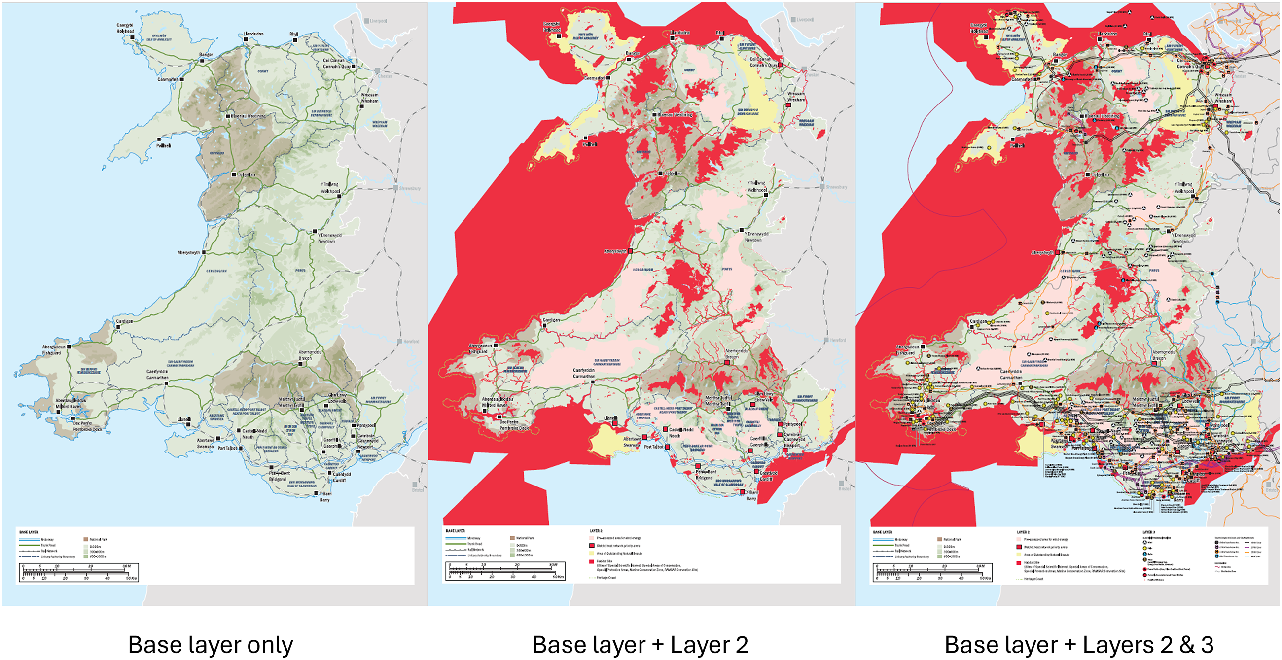
Three layers of energy system map.
As the interviews were conducted during the COVID-19 pandemic, there was an expectation that interviews may well need to be conducted online. With this in mind, physical and digital versions of the map were produced. The physical version was an A1 map comprising three layers, the first being printed on rigid foamboard, and the other two being printed on transparent plastic overlays. There was also a fourth blank overlay which participants could annotate with marker pens. The digital version was a PDF with three layers, each of which could be added or removed by clicking a checkbox, whilst also allowing textual and graphical annotations to be added through Acrobat Reader. Twenty interviews of between 60 and 90 minutes were undertaken between September 2020 and January 2021. The layered construction of physical and digital maps enabled relationships between topological, social, environmental and infrastructural data to be viewed or hidden. This allowed participants to interpret on their own terms both the interrelationships between the distinct layers as well as the spatial logics represented in each layer individually, and in additional to add information they thought was missing, sketch in possible future transformations, and so on. In the end, due to the reimposition of lockdown restrictions within the UK during the interview period, all but two interviews were done online using Zoom.
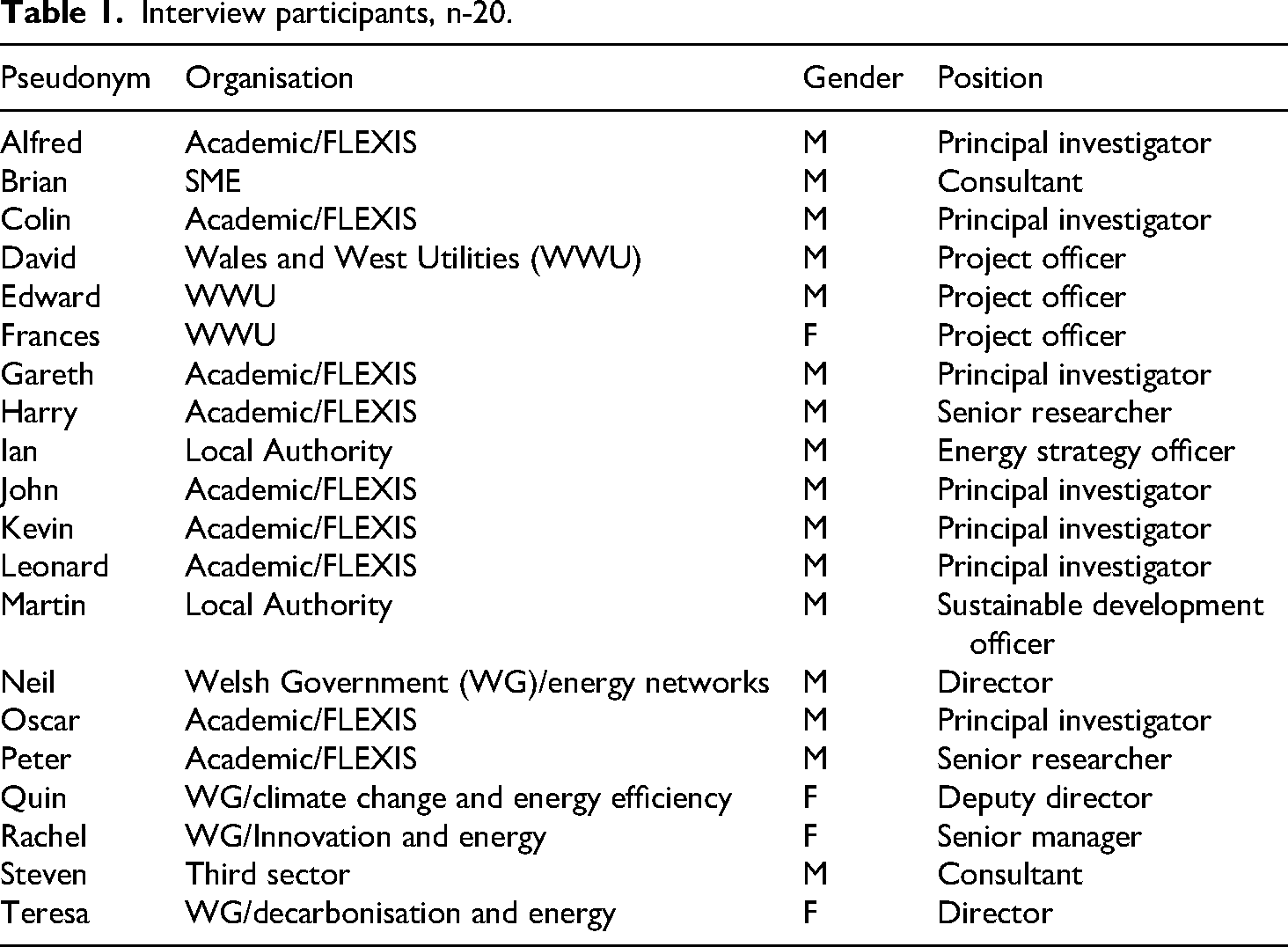
The approach we took aligns with participatory mapping approaches which ask participants to annotate/further illustrate a base cartographical representation (e.g., Boschmann and Cubbon, 2014). The maps were intended to both allow an appreciation of the obduracy and path dependence of the present, and (via the removability of layers and option to annotate and draw on the maps) to allow reflection on ‘gaps’ and opportunities in that same present. As such, and in line with Roberts (2013) and Ravn (2022), the maps were intended as suggestive objects that could evoke insistent, unsettled, futures. The sample, as shown in Table 1, featured several participants who had taken part in the previous round of interviews (shown in bold). Others were recruited using professional contacts to achieve a diverse representation of work areas within FLEXIS and of other categories of stakeholder (paying particular attention to the involvement of different directorates with different policy responsibilities within WG in the project). Participants were interviewed regarding their role on and involvement in the FLEXIS project, and asked to describe key features of work projects associated with FLEXIS in which they were involved. In particular, they were invited to discuss the spatial aspects of these projects (location and socio-geographical context, relations with other projects, connections to other regions and localities within Wales). They were then asked to take some time in examining the map and annotating it to show how they imagined the energy system might change over the next 30 years through to 2050 – showing what forms of infrastructure might be added and where, how social, political and geographical changes might emerge alongside these developments, and what features of the present shown on the maps might disappear and/or be replaced. The interviewer in each case offered prompts to help facilitate the annotating process. After this, the interviewer took each respondent through a series of structured reflections on the changes they had made in order to explore their reasons for the changes they had made.
Interview participants, n-20.
Findings: present futures and future presents in energy maps
Network constraints
Electricity and gas networks are products of the interaction between technological affordances, socio-political and economic structures, and physical geography (Hughes, 1987). In Wales, the processes which shaped these networks include the development of the industrial revolution and the extraction of coal, mainly from South Wales, as the main source of fuel for large-scale steam-powered manufacturing. Later, after WWII, the development of the British nuclear industry saw the building of the Trawsfynydd and Wylfa power stations in north Wales. The high voltage transmission network in north and south Wales, to which large generating assets can be connected, was developed alongside the need to support extractive and manufacturing industry and to connect large power stations (including Trawsfynydd and Wylfa, along with the Aberthaw and Pembroke coal and oil-fired power stations in south Wales, all constructed in the 1960s). These developments reflected projections of demand and required generating capacity that followed on from the development of a high voltage national grid for the UK from 1950 onwards.
Several experts from different backgrounds commented on how the maps, and particularly the energy system overlay, evoked this complex history along with its obdurate legacy, in the shape of a range of socio-technical constraints on the present that would shape the future. They reflected on how they saw this history as the product of political and economic priorities which were evidence of Wales’ significant role as contributor of labour and energy resources to the past socio-economic activity of the UK. Several commented on how the maps confirmed Wales’ position on the periphery compared to England. Well, in my opinion, what you see is a map of Wales with an energy infrastructure that was put into place before devolution. So, what you should see just to understand how that system works, you need to see the map of the UK. (Leonard, Academic, Principal Investigator) The reason all of this stuff built up underneath it, is because of coal. You know, and that's, that was the energy…. So, what happened with industry and population built up because of the energy source that was readily available in those coalfields. (Gareth, Academic, Principal Investigator)
Alongside this evidence of spatial and administrative lock-in (Bridge et al., 2013) and its connection with power, the map nonetheless also opened up reflections on what particular routes might lead into the future. These reflections often solidified into present futures, taking on the shape of extrapolations from what is known about the present. Reading the map evoked interpretations of the key infrastructural problems an energy transition would need to solve, with interviewees typically formulating these in technical terms. For one interviewee, the map presented a spatial and infrastructural analogy with Australia. We’ve got a north islanded grid and we’ve got a south islanded grid. So, if you, if you turned that by 90 degrees that's exactly what Australia looks like. (Alfred, Academic, Principal Investigator)
High voltage transmission lines in Wales run from Trawsfynydd and Wylfa to north-west England, and across south Wales, connecting cities and industrial manufacturing sites there. As Alfred went on to discuss, a key problem in this situation from an infrastructural point of view, drawing again on the Australian analogy, is the limited ability to develop renewable energy production in the mostly rural territories distributed in the area between the two grids, which represents most of Wales. As another interviewee put it, I mean, the one thing, I suppose, that we’ve got to understand from the map […] we need more renewable assets but how does that interact with the grid? Because, you know, it struggles, doesn’t it, to accept, you know, an ever growing sort of renewable base, doesn’t it, really. Our grid currently wasn’t designed for that in mind. (Ian, LA, Energy Strategy Officer) Similar points were made by several participants. Wales was typically described as a resource-rich nation from a renewables point of view, both in terms of exposure to predictable winds, and more generally in terms of the availability of elevated land; lesser valued for agriculture, but highly valued for solar as well as wind power. So, we gotta a north/south issue – right, in terms of population – And if you look in the middle, that's where we’ve got a lot of wind potential (Gareth, Academic, Principal Investigator) I think the challenge in that respect is about the electricity network and whether or not there's the desire to strengthen the electricity network in that area to support those wind developments. (Oscar, Academic, Principal Investigator) Well, I think it's a bit of a no-brainer to say that potentially, the onshore wind resources is very much not where the networks are. (Teresa, WG, Director)
But at the same time, experts saw that there being little planning done to exploit this potential by extending the two halves of the power grid. And there isn’t a clear policy to allow [exploitation of wind energy in mid-Wales] that so that grid companies can plan and put grid lines, or justify putting lines, to take that power away. (Colin, Academic, Principal Investigator)
From this framing of the problem, participants often extrapolated future trajectories for the Welsh energy system in which energy transition would lead to ‘maximisation’ (Colin, Academic, Principal Investigator) of renewable energy production, by exploiting as much renewable (chiefly wind) power as possible. It should be pointed out that maximisation is only necessary if growth in energy consumption – or at least the maintenance of current levels – is also projected. At the same time, many participants also presented maximisation as the obvious trajectory to follow, given the amount of resources available.
In this way, reading the map evoked for many interviewees a framing of the present as presenting society with an infrastructural problem that could be adequately defined in spatial and technical terms. Increasing distribution and generating capacity by extending the grid are, from this perspective, routes into a better future, which face significant obstacles that need to be rapidly overcome. Once such a definition of the problem has been produced, particular kinds of agency are seen as required to unlock planning obstacles and thus solve it. One could argue that a key feature of standard cartographic approaches is the production of an idealised position of a subject who can see the ‘whole picture’. This in turn invites identification with a particular kind of command and control model of governance (Scott, 1998). One interviewee drew connections between the present situation and the planning of the original UK National Grid for power in the 1950s. And similarly, for the grid. Now, I forget his name, but he was an incredibly strong character, he rose to be chairman of Central Electricity Generating Board. So the main thing I wanted to tell you is that these things didn’t just happen by chance, they’re not there just by chance, they’re there by design. […] those senior strategic planners would have done that, you know, in order to provide the kind of infrastructure that the UK has enjoyed. (Leonard, Academic, Principal Investigator)
1
Following these strands through the interviews, the virtual histories evoked by the multilayered map appear to evoke specific imaginative responses, ones which reproduce technical framings of energy transition and tend to view concentration of power as the only way to drive it forward in a timely fashion.
Histories of public opposition
Alongside this theme, others also emerged. Another facet of recent history, the maps evoked for some interviewees was that of public opposition to wind power in Wales and responses to it, chiefly from the WG. Layer 2 of the map shows strategic search areas that were identified by the WG in 2005 in the Technical Advice Note 8 (TAN8) document as potential locations for wind energy generation. One interviewee reflected on these elements of the map at length. […] in refining the areas for TAN 8, there was a bit of logic that seemed to be missed out in my … to my mind which was whilst these are good wind areas that are away from centres of population – so the visual intrusion is less-by the very nature that they're away from centres of population meant that they don't match well with the extent and capacity of grid networks, whether it be National Grid or the distribution network […] So, I think my view is that – and I felt this with the original TAN 8 and I was quite vocal in that at the time – I said what we did was paint ourselves into a corner. (Oscar, Academic, Principal Investigator)
Driven by a need in WG to meet ‘our 2010 targets for renewables’ (Oscar), TAN8 was seen as having encouraged developers to look at areas which were far enough away from centres of population to reduce the prospect of ‘visual intrusion’ (Oscar) and with it, protest. At the same time, this meant that the perceived weaknesses of the power grid in Wales undermined any technical and economic logic for siting. As researchers on public responses to wind power in Wales have pointed out, protests which mobilised against wind development in the strategic search areas based themselves on beliefs about the value of unspoilt rural Welsh landscapes far away from towns and the industrial development, which was felt to have scarred Welsh places in the past (Parkhill et al., 2016). Key to these responses were perceptions of unequal power dynamics between the populous industrialised cities of South Wales and rural Wales, repeating at a different scale the extractive historical relationship between England and Wales. Unspoilt rural landscapes were seen as being exploited for the benefit of regions of Wales to which wealth tended to flow.
Acknowledging this dimension of public responses, Oscar explored the possibility of a different future, one focused on a distinct spatial logic that could represent a political response to public protests against visual intrusion. He alluded to particular examples of Welsh renewable energy visions, such as the Swansea Bay tidal lagoon (Waters and Aggidis, 2016) as positive ‘visual symbols’ of energy transition that embodied the interdependence of society and environment. They represented this as embodying a radically different future for energy transition that would ‘[bring] renewables closer to our communities’, ‘embracing the fact that we accept this challenge as a populace’. Their comments reflected a logic of localisation that was much discussed across the sample as an energy system future ‘more localised to different areas within a region, rather than relying on, you know, distant generating assets’ (Gareth, Academic, Principal Investigator). Here, reading the map as evoking memories of histories of poor governmental decision making and linked public protest opened up the possibility for imagining a different future, one which represented more of a leap from the present (and so, in Adam and Groves’ terms, a future present rather than a present future). In this future, instead of extractive infrastructure being imposed on the landscapes that rural Welsh communities had registered as important to them, infrastructure would be more universally (and implicitly, more fairly) distributed, as well as being linked to localised regeneration, as in the example of the tidal lagoon.
In this case, the layers of information included in the map enabled Oscar to make connections between two distinct histories of the present, and to imaginatively invert the spatial logic of development at the heart of these histories.
Reindustrialisation and value conflict
Responding to the complex virtual histories embedded in the energy system map point, for Oscar, to the need to reimagine a collective response to the multiple constraints on energy system development. This brings us to a broader theme which opened up around ‘gaps’ on the map, more generally. As noted above, the comparison with Australia drives home how the map, for many respondents, demonstrated where ‘gaps’ in the system, embodying the consequences of specific historical patterns of development, could be identified. As Oscar pointed out, these gaps had often been demonstrated through public protest to be in fact full of significance and meaning for communities located in and around them.
Some responses which begin with the identification of gaps represent extractive readings of the map, leading to a static opposition of extractive opportunities to a history of conservation evoked by the areas of restricted development depicted on the map's second layer: ‘I think Wales could have a really good go at exploiting more of its assets’ (Kevin, Academic, Principal Investigator). Once again, these represent present futures – extrapolations from what is known of existing trends. I’d like to just because I think, you know, Wales is quite long coastline, isn’t it, and that access to the seas is, again, is one of our main assets, one of our natural assets. And, you know, we align that with conservation status for those areas is going to be a challenge, but I wouldn’t like to see us – The conservation is important but so is decarbonization and I think we have to balance the two. I wouldn’t like us to see that we can’t build anything in those red areas [coastal conservation areas]. No, I think that would be a little foolish on our part, to be honest. (Ian, LA, Energy Strategy Officer)
Reading the map ‘from above’ for gaps led some respondents to adopt a command and control perspective, with a view to knitting together a comprehensive strategy that looks at production, distribution and supply together, in relation to other aspects of the socio-economic future of Wales. I think there's some really interesting challenges there and, you know, just sort of going into the detail of the map […] [in] Port Talbot is the steelworks and you’re saying, right, so we’ve gotta do this, we’ve decarbonised steel so you’ve gotta use a hydrogen based smelting approach, or whatever it is you’re gonna do. Where does your hydrogen come from? Do… is that a renewable production from Swansea Bay with a barrage? Or, or is it hydrogen coming into Milford Haven because they’ve got the gas handling facilities there already? (Brian, SME, Consultant)
Alternatively, gaps were seen as opening up possibilities for addressing combined social and environmental issues in areas which have historically been poorly served by infrastructure. Reading the gaps in this way allowed respondents to focus on the ways some populations have been ‘left behind’, where there is likely to be increasing demand for energy but not enough supply. We are acutely aware that there's that high density of wind farms, but lower demand, you know, and your map actually shows it quite, quite well, you know, grid constraints. So, there are some particular issues in those sort of areas. But then you could flip that. And that, is that the opportunity? (Quin, WG, Deputy Director)
In such areas, the infrastructure needed to supply demand is lacking, resulting in expensive and higher carbon options being is required. As a result, this reading interprets gaps as demonstrating where a logic of localisation might be appropriate. At the moment in mid Wales we don't have national gas infrastructures and the heating demand is mainly met by electricity, or biomass boilers, or oil, or these type of fuels. So the option for decarbonising heat in mid Wales is really electrification. So, that means if we increase electricity demand in this area, then the best option for supplying that electricity might be using local renewable sources. (Peter, Academic, Senior Researcher)
A common theme across several interviews was how the map enabled thinking about gaps in other infrastructure, such as transport, across rural Wales and how addressing issues here could help develop clusters of combined energy production and storage infrastructure. there's, there's lots of opportunities plus they got 20 stations along that route, so it's been okay, like, if you want to get to the Shrewsbury part. It's a very scenic route but however, you’ve got lots of stop points, where, were not necessarily passenger trains, but you could have milk, milk round collectors going up and down the line picking up the hydrogen, distributing it to South Wales or West Midlands or wherever. (Neil, WG, Director) The easiest way to decarbonise that rail operation is to run that through hydrogen. And, again, what that would potentially lead to is no … a series of nodes and it may be no more than five, six, seven maybe 10 maximum nodes throughout Wales where you've got renewable production of hydrogen that, you know, that then allows for refuelling of trains at depots. (Oscar, Academic, Principal Investigator)
These developments were often imagined as putting in place a foundation for improving transport infrastructure for freight and public transport across rural mid Wales. If you’re living in any of the towns or villages that are currently shown on that map, you need range, you will need some range. So from that point of view, I think it's entirely feasible that, you know, and you probably see that it would be aligned with, you know, the market towns and Newtown and Llanidloes and, you know, these sort of places, all around there. I think it's very likely that we would see the development of hydrogen refuelling. (Oscar, Academic, Principal Investigator)
Nonetheless, all these responses begin from the identification of spatialised gaps in an energy system and lead on to broader questions that in some cases invite imaginative engagement with specific future presents, such as an imagined national picture of Wales in which a variety of societal and environmental values are harmonised. In these imaginative leaps, the narrative that connects future to present remain to be worked out, inviting critical reflection on what is familiar to us in the present. Now who's to say in 100 years’ time, you know, with all the wind turbines in the middle where it's blowing the wind – You know, the, the vast, you know all those beautiful hillsides, you know, why wouldn’t anyone wanna live there? Well, the reason they don’t wanna live there at the minute cos there's no jobs there, and there's no communities. But I bet if you went back 200 years ago, before, you know, the mines were working, there probably was no one there either. (Gareth, Academic, Principal Investigator)
In this quotations, we see Gareth begin by extrapolating from established growth trends in onshore wind deployment but then shifts to evoking a future present that invites reflection on ‘what kind of Wales’ energy transition could make possible. The map, at this level, evokes a range of historically situated values that are associated with particular assumptions about Wales (e.g., the concentration of industrial employment and the importance of manufacturing in some locations, as well as the larger unspoilt rural Wales), whose compatibility is placed in question by the present. Imaginative leaps into future present offer attempts to resolve these tensions and conflicts between values.
The present was often seen by interviewees as politically problematic within Wales. Decarbonising the energy system was generally seen as a goal which challenged a variety of public values that had shaped previous conflicts in Wales over energy infrastructure. The value accorded to Welsh landscapes, reflected in the boldly coloured protected areas to which interviewees often drew attention on layer 2 of the map, was seen as a key feature of debates over infrastructure and development more broadly, but as potentially problematic, given the need to address in some way the gaps in the system. Whatever way forward was chosen for decarbonisation, the future was seen as only being imaginable through a lens of conflict and hopefully renegotiation of these values. As we noted above, Oscar (Academic, Principal Investigator) addressed this theme by imagining a redistribution of the ‘burden’ of infrastructure, which he saw as being made possible by a remodelled, highly decentralised future energy system. Harry (Academic, Senior Researcher) also focused at one point on the theme of how to emplace energy infrastructure development within a Welsh context in ways that recognised the value of landscapes, while also moving in the direction of something like a reindustrialisation of Wales. In rural Wales, ‘instead of having a big infrastructure that connects the entire country, you might have just small cells just connecting those small towns or locations’, meaning that the system ‘will have to evolve’ in a direction where instead of ‘having only one solution’ to the historical tensions embodied by the gaps in the grid, there will need to be ‘a mixture of many’ (Harry).
Discussion
Assumptions about expert perspectives are often framed in reductive terms – such as ‘engineers think like this’. Critical scholarship on the relationship between technical expertise and power has highlighted how expert discourses can suppress reflexivity, particularly toward the deeper assumptions embedded within expert worldviews. Given that reflexivity is considered a vital capability when considering potential futures, this raises an important question: does the value of expert knowledge decrease in relation to complex, uncertain futures? Other, less stringent critiques of expert reflexivity suggest that the opposite is true, and that reflexivity is central to expert perspectives, though these may undoubtedly exhibit constraints, particularly where a key goal is to open up ways of imagining potential futures differently. As noted in the literature review, researchers have often used maps as objects wich which to create new opportunities for thinking differently about the future. In this article, we have explored whether maps might serve a similar function in expert interviews. Specifically, we examined whether using maps as ‘things to think with’ can invite experts to reflect on their assumptions – especially those that tend to lead to futures imagined as mere extensions of the present.
Our findings confirm research that suggests maps, as evocative objects, can indeed exceed the fixity often attributed to them – particularly in the context of energy system mapping. Used as ‘things to think with’, they may embody multiple intertwined virtual pasts while also holding open futures that, together, ‘haunt’ the mode of representation usually associated with maps. Using them as part of the process of posing the questions that are central to a theory-generating expert interview may, we hypothesised, create opportunities for reflexivity. As well as evoking historical narratives that account for the present through the past, maps may hold within them latent tensions that point forward in particular directions. In this way, a map can alter the meaning of interview questions, prompting deeper reflection. Conversely, interviewers may ask additional questions in response to how participants interpret the map, helping surface ‘latent futures’ that haunt the present. A map, viewed in this double-sided manner, enables the question ‘how could things be different?’ in an enriched way, even as they may also reflect dominant narratives about how things came to be.
The central conceptual pairing we have used to analyse the role maps in our expert interviews has been distinction between present futures and future presents – two different ways of orienting toward the future from within the present. Present futures represent the future in ways that reflect habituated and familiar trajectories, and thus tend to mirror unquestioned assumptions about past and present. In contrast, future presents tend to be synthetic, bringing together a variety of potential and often partial trajectories into an imaginative representation of a future that does not simply extend already recognised trends. Future presents embody imaginative leaps that can then invite reflection on the assumptions upon which present futures may have been constructed. Our use of maps demonstrates that experts may interpret them in ways that express present futures – such as the need to ‘maximize’ renewable energy outputs (an interpretation that rests on the unexamined assumption that maximisation is inherently desirable. In these cases, the ‘gaps’ many experts found in the maps were seen as deficiencies to be corrected – historical shortcomings that must be overcome to meet decarbonisation goals. This interpretation often focused on infrastructural gaps, mismatches between supply and demand, or inefficiencies in resource use. One direction of interpretation which moves through the interviews may therefore be seen as relatively unreflective. This identifies historical infrastructural trajectories, shaped by socio-economic priorities and an unequal political relationship between Wales and England. These trajectories are seen as having posed a problem for decarbonisation that recent responses from WG and other actors have not successfully addressed. A key focus of this interpretation is to use the maps we presented to identify lacks – infrastructural gaps, gaps between demand and provision, gaps in the efficient exploitation of available resources. Based on these readings, interviewees imagine ways of closing these gaps that focus primarily on command and control approaches, ones aimed at developing efficient modes of system management suited to a new Welsh energy system built around renewables.
However, the layered structure of the maps also opened up alternative interpretations. Several interviewees engaged actively with the map's interactive features – clicking between layers, expressing fascination, and noting how the format prompted new ways of thinking. One interviewee described being ‘intrigued and jealous of the map that you showed’ (Oscar, Academic, Principal Investigator), while another remarked that ‘it's a good thing to get you thinking’ (Rachel, WG, Senior Manager). These responses suggest that the maps’ credibility and visual richness invited reflection on the spatial logic of energy systems and the socio-political assumptions embedded within them.
In particular, some participants interpreted the gaps in the map not as deficiencies but as opportunities – spaces for imagining more decentralised, democratic approaches to energy infrastructure. This interpretation linked the maps’ visual absences to broader historical and political narratives, including Wales's post-industrial legacy and its evolving relationship with the UK energy system. This was evident in discussions around opportunities for decentralising energy that might challenge the target-led, top-down models of development that in the past had stimulated opposition to wind energy development in Wales. Interpreting decarbonisation as a potentially more ‘democratic’ distribution of the burdens of infrastructure was an example of gaps becoming sites for imagining future presents – futures that emerged from the synthesis of infrastructural, socio-economic, and ecopolitical histories. While still focused on ‘gaps’, these interpretations reworked their significance, using them as springboards for alternative imaginaries.
However, the imaginative production of future presents in our interviews often remained an initial step. What was missing was a deeper interrogation of the implications of these future presents for the assumptions upon which more familiar present futures rest. To fully explore the potential of this methodological approach, a more reflective and perhaps deliberative component is required. One next step could be building prompts into interviews that explicitly invite participants to connect imagined futures to present socio-economic conditions – for example, by asking how a vision of reindustrialisation might relate to Wales's history of deindustrialisation and its current valorisation of landscapes for tourism. How could the value conflicts it implies be brought out and opened up to critical reflection? Another possibility would be to extend this approach into a fully deliberative setting, involving both expert and non-expert participants in structured reflection on the values and trajectories shaping energy system decarbonisation. Such an approach could help surface value conflicts and open up space for upstream engagement with alternative futures. We would suggest that this method is adaptable to other contexts, though careful attention must be paid to design. Presenting information in layered formats to evoke distinct histories requires thoughtful consideration of what constitutes credible representation in each setting. Working with professional designers to translate a variety of data sources into visual formats was for us a key element in considering these issues, though this might not be so for researchers working on other topics.
Conclusion
In this paper, we have explored how the use of maps as ‘things to think with’ in expert interviews can open up opportunities for reflexivity –particularly in relation to socio-technical change. Drawing on methodological research that challenges the view of maps as static representations that encode dominant narratives, we have instead emphasised their capacity to embody multiple temporalities. Following Roberts (2013) and others, we have characterised these temporalities in terms of hauntings, virtual resonances between maps’ representational functions and both alternative pasts and potential futures. Specifically, we suggest that the evocative qualities of maps lie in their ability to facilitate imaginative leaps towards synthetic future presents – visions of futures which do not simply extrapolate from past trajectories. These imaginative futures can prompt critical reflection on the assumptions underlying more conventional present futures. In this way, maps can support expert reflexivity in a manner analogous to their use in participatory research with marginalised groups. As Perera (2020) has shown, maps can prompt shifts of positionality, and we have documented similar effects in our own study. Using multi-layered maps of the Welsh energy system offers insights into how experts may interpret visual ‘gaps’ in different ways. Some viewed them as infrastructural deficiencies requiring technical solutions – an interpretation aligned with present futures. For others, however, reading across map layers led them to frame the problems encoded within the maps very differently, synthesising different histories into interpretations of future possibilities that speak to other dimensions of concern relating to energy. These interpretations exemplify future presents – imaginative syntheses that challenge dominant assumptions and open up new possibilities.
The case study we have presented therefore underlines that the critical use of maps can extend beyond established canonical and undoubteldy important uses, e.g., in providing marginalised groups with tools to critique dominant narratives. We have shown that their use as tools for reflexivity can extend into engagement with experts. The stress placed within STS and environmental sociology on the critical imperative to be reflexive about assumptions regarding the future, has, we suggested, often created assumptions in turn about the nature and particularly the limitations of expert reflexivity. The use of maps as evocative objects represents, we suggest, one way of investigating these assumed limitations and in some cases overcoming them.
By treating maps not simply as encodings of power but as generative, affective, and interpretive tools, we may open up space for experts to engage with alternative futures. These futures are not necessarily simply projections from what is already known, but may become imaginative constructions that emerge out of the complex associations maps evoke. As such, maps can help move expert discourse beyond present futures and toward more reflexive, anticipatory engagements with the future.
We have suggested that this approach is adaptable to other contexts. However, we emphasise that careful attention must be paid to design – particularly when using layered formats to evoke distinct histories. In our case, collaboration with professional designers was essential in translating diverse data sources into compelling visual formats. While this may not be necessary in all settings, researchers should consider what constitutes credible and evocative representation in their specific context. Used thoughtfully, maps may offer a powerful means of constructing future presents and fostering deeper reflexivity in expert engagement with futures.
Footnotes
Author note
This research was conducted while Groves and Roberts were employed at Cardiff University. Christopher Groves is since 1 February 2024 affiliated with the Department of Criminology, Sociology and Social Policy at Swansea University, UK; Erin Roberts is since 30 June 2024 affiliated with the Department of Geography at Swansea University, UK.
Ethical considerations
Ethical approval for this research was obtained from the Cardiff University School of Social Sciences Ethics Committee on 7 July 2021.
Consent to participate
Written consent was obtained from all participants.
Author contributions
Christopher Groves and Erin Roberts: designing and conducting, underpinning research, conception, and writing. Karen Henwood, Gareth Thomas, Nick Pidgeon, and Fiona Shirani: reviewing, editing, and proofreading.
Funding
The authors disclosed receipt of the following financial support for the research, authorship, and/or publication of this article: Support for this research was primarily provided by the Welsh Government through the European Regional Development Fund as part of the FLEXIS project. Prof Pidgeon acknowledges support from the EPSRC UK Energy Research Centre Phase 4 and 5 (EP/S029575/1) and ESRC Behavioural Research UK Leadership Hub (ES/Y001044/1); Dr Roberts and Prof. Henwood acknowledge support from the BBSRC Greenhouse Gas Removal Project (BB/V011359/1).
Declaration of conflicting interests
The authors declared no potential conflicts of interest with respect to the research, authorship, and/or publication of this article.
Data availability statement
No associated datasets are available for this article.