
Abstract
In digital cartography, Google Maps and Google Street View (GSV) are often used side-by-side at the computer interface. This study consists of an analysis of recordings of Geoguessr, an online game that presents players with GSV imagery and challenges them to guess the location of the images on a digital map. Gameplay requires semiotic moves that put the diagrammatic signs of the GSV images and the map into a dynamic interplay. By specifying these practices, the present analysis offers a processual, practice-oriented perspective on theoretical debates in the study of digital mapping. Rather than existing a priori, the constructed or transparent nature of the map, as well as the kind of cartographical subject involved in manipulations of the map both emerge and change through the practical use of the two representations. Furthermore, the abductive inferences that characterize particular moments of gameplay constitute an intersection of reasoning and play.
Introduction
Digital mapping systems such as Google Maps have not only transformed the geographical sciences but also have made an impact on ordinary smartphone users who orient themselves, survey nearby attractions and determine a route to their destination with the help of digital maps. For many years, these tools were limited to the top-down perspective common to traditional maps. In 2007, Google launched Google Street View (GSV), which offers omnidirectional photographs of streets and other public spaces that are captured by a camera assembly mounted onto a car or truck, sometimes called the Google Car. The imagery is made accessible through an online interface that allows users to load new images by pressing directional buttons, giving the impression of exploring a street from the perspective of a pedestrian. GSV is also accessible to developers through an application programming interface (API) which makes it easy to integrate the image data into other programs and systems. GSV currently offers at least some coverage of over 90 countries (Biljecki and Ito, 2021: 2).
Because of the accessibility of the GSV imagery database, it has become a key resource in geographic information science (GIS) projects including classifying road types, quantifying the amount of green space in urban areas, adding detail to top-down maps and even using signs and other typographic features to approximate population demographics (Biljecki and Ito, 2021).
Another novel application of GSV imagery is an online game called Geoguessr. The game presents users with GSV imagery and then challenges them to determine the correct location of the GSV images on a digital world map. As is the case with other online games including chess and Age of Empires, Geoguessr is also an emerging spectator game on platforms like YouTube and Twitch (Gros et al., 2017). This study consists of an analysis of Geoguessr YouTube videos from an account called GeoWizard, which demonstrate how gameplay is practically accomplished. There exists literature on the novel forms of geographical thinking and seeing afforded by GSV, but none that adequately considers how GSV and top-down digital maps are practically integrated in real activities, as is required by many of the GIS projects described above. GeoWizard’s narrated video recordings of Geoguessr gameplay offer an ideal look into these practices.
Guessing is a semiotic task carried out through the recursive manipulation of two kinds of representation: the Google Map and GSV imagery. Like all maps, both of these represent their objects by virtue of structural similarity, making them what semiotician C.S. Peirce calls diagrams. GeoWizard manipulates one of these diagrams so as to find clues about how to manipulate the other, repeating this process until he develops a guess—a single “place” that emerges as the two representations are brought into alignment. While not all Geoguessr gameplay consists in this process, GeoWizard highlights it as the most entertaining and satisfying component of the game.
Theoretical inquiries from fields including communication, information studies, cultural geography, and media studies consider digital maps as not just static representations, but rather interfaces with particular affordances that are only realized through their use. Peircean semiotics offers tools with which we can go beyond describing the interface as generally constituted by active manipulation, and specify the moves that constitute these manipulations. The notion of diagrammatic inference is used because it allows a focus on active processes—“it liberates semiotics from the static idea of the en- and decoding of signs, because the interesting part of semiotics lies elsewhere, in the epistemological dynamics of diagram interpretation” (Stjernfelt, 2000: 379).
Specifically, the map and GSV representations of Geoguessr are diagrammatic signs which facilitate inferences based on recursive manipulations, with transformations of one inspiring a “guess,” or what Peirce would call an abductive inference, about how to productively transform the other. GeoWizard repeats this process iteratively, first focusing on one representation and using the other as context, and then, by means of an abductive leap, switching focus to the other representation that was the source of context. Abduction is here shown to distinguish the ambiguous and uncertain transformations and manipulations that link practices of reasoning and those of play.
Rather than showing how the digital cartography of Google Maps and GSV is material and contingent rather than objective and transparent, the present analysis shows how, through the activity of gameplay, it may come to be seen as material and contingent in the process of strategically reconciling two representations and venturing a guess. Similarly, the kind of cartographical subject who views the map changes over the course of gameplay, as GeoWizard strategically considers himself immersed, using the interface as an “eye” or a “window” into the world of GSV, and also is able to step back and separate himself from the limited perspective of GSV cameras and the top-down cartography of the map. This study does not suggest a particular kind of map-viewing subject a priori, but rather shows how this subject position changes through the strategic moves of gameplay.
Theoretical background
Digital mapping technologies have had profound consequences for the field of geography, including the emergence of the interdisciplinary field of geographic information science (GIS), in which analysts use databases of geographic data for statistical analysis and visualization. GIS itself has been critically analyzed by social scientists, including those that describe their work as “Critical GIS.” This approach, with its basis in Marxist geographies, the critical theory of the Frankfurt school, post-structuralism and feminist geographies, has advanced an emphasis on political economy, the racialization and gendering of space and spatial representations, reflexivity in geographic practices and also an attention to what Andrew Pickering (1995) calls “the mangle of practice” that constitutes the interplay of geographers, collaborators and technologies (Sheppard, 2005). Work in this area includes critical investigations into Google Maps and GSV, technologies that exemplify key parts of the contemporary GIS toolbox.
In a theoretical investigation of the epistemological basis of GSV, scholars ask how GSV complicates the notion, long held in geography, of “the map as an invariant abstraction that coordinates fixed information” and the related contention that “aerial imaging and its vertical gaze provide a disengaged ‘view from nowhere’” (Gibson, 2014: 251; Shapiro, 2018: 1202). In another common strand of critical investigation into GSV, scholars with approaches informed by phenomenology and visual culture ask about how Street View brings with it new ways of interacting with places and spaces. A new kind of GSV subject has been theorized—a subject that emerges due to the ability of the GSV interface to “approximate the perceiving, embodied subject, thereby producing its natural assimilation” (Gilge, 2016: 477; see also Uricchio, 2011: 25). This article addresses these theoretical issues from a practice-oriented perspective, demonstrating how the naturalness or constructedness of the map, as well as the kind of subject that navigates it can emerge and change through the processes of digital cartography.
The present emphasis on the dynamic activities of cartography rather than representational content of maps is indebted to broader critiques of representation. The spaces that geographers study, which have long been considered geometric grids that could be objectively determined according to natural properties, have recently been theorized as meaningful only in relation to the social practices that constitute ways of being in space (Massey, 1994). In response to this emphasis on social processes, some scholars have proposed the use of actor-network theory to accommodate not only social constructions, but also the non-human actors and materials involved in complex geographical systems (Koch, 2005). Furthermore, some critics contend that spaces themselves can be brought into being as the result of social practices (Kitchin and Dodge, 2011: 67). These theories shift the focus of geography from objects of the world which can be more or less accurately placed into the objective, a priori space of the cartographic grid, to the processes through which objects and spaces come to exist as such.
While this theoretical foundation might seem to conflict with the semiotic approach, which is known, in part, from the work of structuralist semioticians like Ferdinand De Saussure (2011), nonrepresentational approaches to geography are well served by the semiotics of C.S. Peirce. While Saussure’s semiotics isolate the meaning-making process within mental structures of interpretation, Peirce’s approach accommodates the dynamic forces of the contextual world as such. Hansen-Møller (2006) uses this distinction to reconcile semiotics and Lefebvre’s theories on the production of space, on which his semiotic analysis of landscape is based (p. 89). Applications of Peirce’s theories in contemporary and digital geography also include Scollon and Scollon’s (2003) “geosemiotics” and Jaworski and Thurlow’s (2011) study of semiotic landscapes (see also Almeida, 2002).
By attending to particular instances of interaction between a human user, digital maps, and GSV imagery, this article demonstrates what is required to strategically coordinate these two kinds of representation—activities which “[illustrate] the power of connecting highly local events within a standardized, global geographic scheme” (Dalton, 2013: 264), and through which “the synthetic operations of assimilating . . . disparate views become efficient and eventually habitual” (Gilge, 2016: 479). The detailed, qualitative nature of this inquiry follows from the suggestion in Laura Kurgan’s (2013) study of digital mapping that “only through a certain intimacy with these technologies—an encounter with their opacities, their assumptions, their intended aims—can we begin to assess their full ethical and political stakes” (p. 14).
Alongside this theoretical cannon in critical geography is the growing literature on online gaming websites like Twitch.tv, which host streamers who broadcast their games to a live audience. Twitch is the topic of a diverse body of research with a range of approaches and foci (see Harpstead et al., 2019 for a review). Recordings of Twitch steams are a valuable resource for researchers because, like the YouTube videos studied here, they include “thinking aloud” narration practices, a “part of the game streaming ecosystem” that gives insights into the processes of streamers (Harpstead et al., 2019: 112). Also like Twitch streamers, YouTube content creators are often aware of the financial prospects of content creation and strategize around financial opportunities of video sharing (Bingham, 2017). The present case is unlike Twitch; however, in that it lacks live social interaction between streamer and viewers who, on Twitch, can comment in a chat window in real time. These interactions have been theorized as a cultural “third place” and a locus of sociability and participatory community (Hamilton et al., 2014; Johnson, 2019; Nematzadeh et al., 2019). The present case consists of YouTube videos that are uploaded after gameplay has taken place and therefore relates to games that have been studied on Twitch, but not to the social dynamics of Twitch streams and chats.
Methods
This study investigates Geoguessr practices through a multimodal interaction analysis of gameplay recordings that have been uploaded to YouTube by an account called GeoWizard. This analysis is primarily concerned with the interactive moves by which GeoWizard accomplishes the task of the Geoguessr game, which consists of reconciling two kinds of representations, GSV and Google Maps, in order to determine the target location. Each round, a number of points, from zero to 5000, is allocated based on proximity of the guess to the target location. The game also includes other modes including head-to-head contests for best distance or longest streak of correct identification of country. These game modes, which build on the classic individual game mode studied here, are not part of this study.
Interaction here does not refer to interpersonal exchanges between players, a key part of multiplayer online games, but rather the way the user interacts with the Geoguessr interface: a player’s action, such as clicking the forward facing button on Street View, is met with a response from the Geoguessr system, which is built on the Google Maps and GSV APIs. Because our interest is in the video as a record of the Geoguessr activity, rather than social dynamics of YouTube, the study foregoes analysis of YouTube comments, focusing on video content alone (Androutsopoulos and Tereick, 2016: 367).
The analysis focuses on particular vignettes that illustrate moments of game play. The first step in this process was selecting a YouTube channel called GeoWizard as the lone YouTube uploader to contribute to the sample. He was selected because he has the most extensive collection of Geoguessr uploads that include moving, panning, and zooming, which, as is explained below, is the most dynamic kind of gameplay. Furthermore, his account, as one of the earliest and most popular Geoguessr channels on YouTube, offers the most extensive insight into the activity. A single account was selected, as opposed to a variety of differing accounts, so as to allow the possibility of demonstrating how the repertoires GeoWizard engages in become routine for him and his viewers, and other ways in which his commentary relies on patterns established over his body of work. The selection of a single account was also inspired by nonrepresentational analyses of online videogame streaming, such as Zhang and Hjorth’s study of gender performance by the streamer Hani9. These authors demonstrate how Hani9’s agency is constituted by particular moves of their performances and how the structural or schematic meanings of, in their case, gendered identity, are frequently disrupted and modified as part of the performance (Zhang and Hjorth, 2019: 810–811). This finding supports our choice not to study a set of streamers for the sake of identifying patterns in their performances, but instead focus on one uploader, their patterns of activity and the ways in which they break from these patterns.
To gain insight into all of the possible interactions allowed by the GSV interface, I sampled GeoWizard videos that include the most active version of the Geoguessr game: one in which moving through, panning across and zooming into the GSV images are all allowed. This excludes many videos that show GeoWizard attempting the more challenging “no moving, panning or zooming” (NMPZ) mode. Some GeoWizard videos that show the moving, panning, and zooming mode were still omitted because they were restricted to 30 seconds per round—these rounds rarely include “moving” due to time pressure. Some videos were omitted because of the “game map” GeoWizard selects for the game. The game map is the set of possible target locations the guesser could encounter. Local game maps produce target locations within a single city or region, as opposed to global maps which offer the entire global library of GSV images. This study includes analyses of only those rounds that use a map called A Diverse World—GeoWizard’s preferred global map.
The videos were then downloaded, imported to ELAN, viewed, and coded for systematic patterns, following Potter and Wetherall’s practice-oriented discourse analysis method, which emphasizes the search for “functional effects and consequences” (Potter and Wetherell, 1987; Winter et al., 2015). Videos analyzed are listed in Appendix 1. Systematic patterns include Geoguessr moves that make distinctive use of the representations available, such as the “retrace,” a pattern that describes the task of finding one’s way back to the target location from another place the location of which one was able to determine. While some of these patterns were hypothesized in advance on the basis on my informal experience with the game and with GeoWizard’s uploads, many emerged in the process of coding. For this reason, several videos had to be re-coded as the coding scheme became more sophisticated. Notions of reliability and bias in this coding exercise are not a concern because coding was not conducted in service of a quantitative analysis. Instead, coding was a practical tool for determining which videos would be best suited for a close analysis of interactions in the particular case.
Using the results of the coding process, I selected vignettes that demonstrate the practical moves of Geogeussr, following the work of Bennerstedt and Ivarsson, who present select vignettes of online gaming to illustrate relevant actions. These authors investigate video game actions using an interaction framework that was originally developed for in-person interactions in the fields of ethnomethodology and conversational analysis (Bennerstedt and Ivarsson, 2010). While much of their work focuses on the social interactions that occur between players in online multiplayer gaming, the role of the environment of gameplay is also essential—Bennerstedt and Ivarsson go as far as to quote Adam Kendon (1985), arguing that, in the case of gaming, “there is a systematic relationship between spatial arrangement and mode of interaction.” They continue to suggest that online videogames constitute what Eric Sudnow (1983) calls “terrain for human involvement.” While they lack the social interaction of multiplayer games, GeoWizard’s Geogessr videos are similar to the gameplay that Bennerstedt and Ivarsson study, as they offer a view into the way users practically cope with digital environments and manipulate representations to strategically modify the environment. The importance of strategically modifying representations of the environment is not unique to Geoguessr, but rather a common feature of multiple forms of online gaming.
The approach taken here, which follows from ethnomethodology, aims to describe the locations that constitute GeoWizard’s guesses not as a part of a cultural text or a political imaginary, but rather as the practical accomplishment of the particular activities of Geoguessr (Garfinkel, 2002). In this way, this study responds to Ross Gibson (2014) who, in an article from the field of cultural studies, suggests to the reader, “try monitoring yourself as you work with Google Maps,” implying that while it is possible to gain insight into GSV from a theoretical vantage, the GSV interface elicits its own unique kinds of moves and manipulations that can be best understood by participating in or observing the activity itself (p. 256).
Analysis
The most basic Geoguessr activities are exploring the GSV representation of a place and exploring a part of the world map hypothesized to constitute the target location. Making connections between the two representations so as to determine the location of GSV imagery on the map is the unique challenge of Geoguessr.
The two representations of Geoguessr
The beginning of every round of Geoguessr starts with the presentation of a single GSV image. In rounds in which panning and zooming are allowed, the user can click and drag to bring different parts of the omnidirectional image into view, and can use “+” and “−” buttons (or a mouse scroll-wheel) to zoom in and out. 1 In rounds in which moving is allowed, white, translucent arrows are projected onto the GSV images to appear like forward and backward buttons on the ground. In rounds that allow moving, panning, and zooming such as those analyzed here, the player typically begins by panning, zooming, and using the white arrows to “move around”—clicking the arrow loads a new image that shows a slightly different area. The map is located in a small window at the bottom right corner of the GSV image. The player can click and drag to move the map to the north, south, east, and west. They can also zoom in and out of the map.
Toward iterative alternating manipulation of the two representations
The most complex rounds of Geoguessr require investigating both kids of representation, the GSV images and the map, using clues from one to direct manipulations of the other. However, easier rounds do not require this level of engagement. Some Geoguessr rounds feature the early discovery of a road sign that indicates a place that is likely to also be indicated on the map, leading to what I call a road sign–based map search. To carry out this search, GeoWizard routinely organizes the windows of the Geoguessr interface to make the sign clearly visible beside the map (see Figure 1), at which point he scans the map to find the place name. Road sign–based map searches make little use of the interactive semiotic repertoire highlighted in the present analysis. They are also seen, by GeoWizard at least, as the least entertaining part of Geoguessr videos. GeoWizard assures his viewers that road sign–based map searches only make up a small fraction of the game. Also, he often edits his videos to artificially speed up the recording of these map searches. Road sign–based map searches lack the complex semiotic activity of abductive diagrammatic inference explained below, which, beyond the mechanistic matching of road sign words to words on a map, can be considered a form of complex reasoning, problem-solving or play.
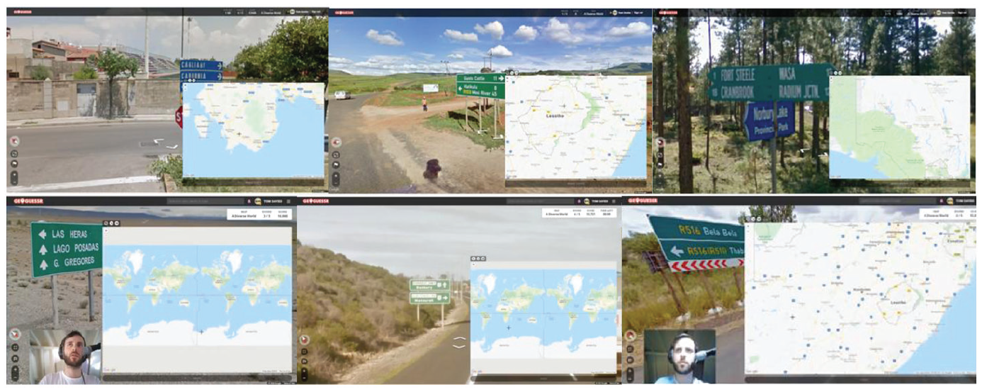
Collection of screenshots showing window arrangement during road sign–based map search (video IDs clockwise from top center: 3, 3, 8, 7, 2, 4).
Geoguessr may seem to be as simple as picking a place on the map on the basis of what is seen in GSV. The first dynamic of gameplay that complicates this explanation is the presence of map clues, features of the top-down map that inspire a hypothesis about the target location or the next move through the GSV images. The presence of clues in the map is generally evidenced by the fact that there exist game modes in which the maps lack labels, to increase the challenge. GeoWizard takes this even further in some videos, called “No map challenges” (not analyzed here), in which he does not use the map at all and simply guesses a place name aloud.
GeoWizard makes use of a clue from the map in Vignette 1, which shows how, after lamenting the dearth of road signs that could enable a road sign–based map search, he looks to the map for clues and quickly identifies a stretch of road that could match the GSV imagery. In this case, GeoWizard implies that the turn to the map was an alternative to continuing to search for road signs in the GSV images.
GeoWizard switches from searching the GSV imagery for road signs to exploring the map for clues. He then determines a possible stretch of road that might match the GSV imagery. Red circle added to show mouse position [VID 5].
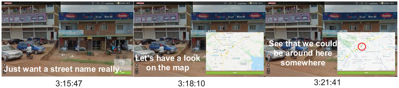
Another common activity involving map clues is a reversal of the road sign–based map search in which GeoWizard searches the GSV images for a feature that is indicated on the map but not clearly present in the GSV. Vignette 2 exemplifies this map clue-based activity, showing GeoWizard searching for a small road indicated on the map that he did not see when he first navigated the area on GSV.
GeoWizard returns to GSV images he had already seen in order to identify a small road that he learned about by looking at the map [VID 1].
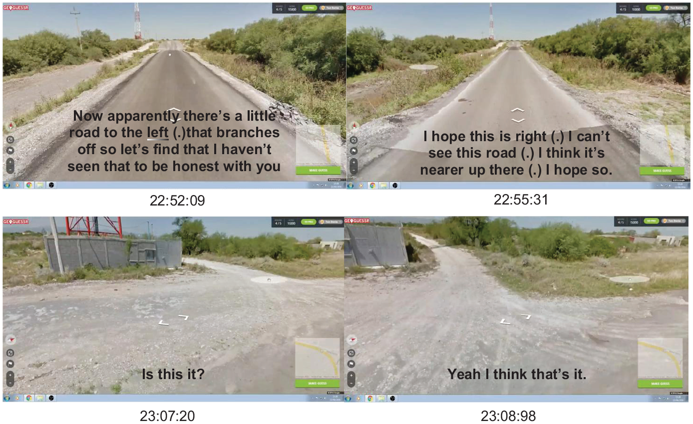
Because Geoguessr activities can start with GSV clues and lead the guesser into the map, or begin with map clues and lead the guesser toward GSV images, it is possible to alternate between the two kinds of representation, using the map to confirm GSV clues and also to inspire the search for new items not yet identified in the GSV images. This kind of activity is a primary strategy for determining a precise location when general clues like road signs have lead the guesser to a particular town or city.
Part of a GeoWizard round in Sweden, shown in Vignette 3, features a series of comparisons between the GSV imagery and indications on the map. In each comparison, a feature emerges as a blend of aspects of each representation. A crossroads, the first feature that emerges in this activity, is discovered and indexed on the map, after which GeoWizard minimizes the map to scan the GSV imagery. He then concludes there is no matching crossroads. This is shown in the top two screenshots of Vignette 3. Then, he moves on to investigate a lake that he sees in a GSV image. GeoWizard demonstrates how the lake emerges as a feature, mapping correspondence between the two representations by moving his cursor across the GSV image from the road “down to the lake,” and then performing a transposition of this action on the map, again moving from the road “down to the lake,” this time moving at a different angle and speed to accommodate the difference in projected space between the two kids of representation (shown in the third and forth screenshots of Vignette 3). Finally, GeoWizard investigates a road, presented in the final two screenshots of Vignette 3, first showing how the road on the GSV image “just leads to a house” and then showing a more extensive road on the map. As was the case with the crossroads, the road to the house fails to emerge in the blend between the two representations and thus fails to constitute a useful clue.
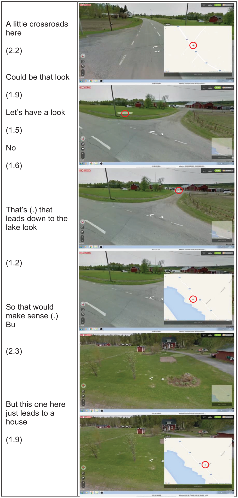
GeoWizard alternates between the GSV imagery and the map, iteratively using clues from one to inform manipulations to the other. Red circle added to show mouse position [VID 1, 15:59–16:20].
This iterative process consists of an investigation into one representation that is guided by a clue from the other representation. What was observed in the GSV images becomes background or context for inspecting the map, and vice versa. Each transition from one representation to the other requires a hypothesis or guess that posits some similarity between two representations which have yet to be fully understood as showing the same place.
The Geoguessr subject substituted for the Google Car
GSV imagery is designed to emulate a first-person point of view. GeoWizard’s narration reflects this perspective—he often substitutes himself for the GSV camera assembly, or “Google Car,” that occupied the position from which the omnidirectional images were captured. While the Google Car which captured the imagery is often, in GeoWizard’s commentary, interchangable with the “I” or “we” of the Geoguessr subject, that is not to say that the car is invisible, or that the user, lost in an immersive experience, forgets about the car entirely. The Google Car is brought to the fore of GeoWizard’s commentary in cases when the imagery it captures makes conspicuous the contingent nature of the Google Car’s vantage point, which is limited by its size, speed, and the rules of the road that its driver follows. In Vignette 4, the first two frames show GeoWizard using the cursor to indicate a narrow passage. The final frame shows a successful attempt to load a new image of the space on the other side of the passage. His narration of this interaction makes use of a blend between the agential capactiy of the Geoguessr user, “we,” and the Google Car’s physical size, which is thought to potentially pose an issue. The Google Car can also become conspicuous regarding its speed and navigation, drawing further attention to the distinction between the Geoguessr user as a free agent who navigates as they please, and the Google Car, which captured a particular set of images contrained by the single path it took through the environment. In Vignette 5, GeoWizard is unable to check the side of the road for signs because the view is obstructed by a large truck. At this point, the passing procedure of the Google Car becomes conspicuous and GeoWizard assesses it as “very slow.”

Metonymic substitution of “we” for the camera assembly, and a blend of subject’s movement with access to further GSV imagery [VID 1].
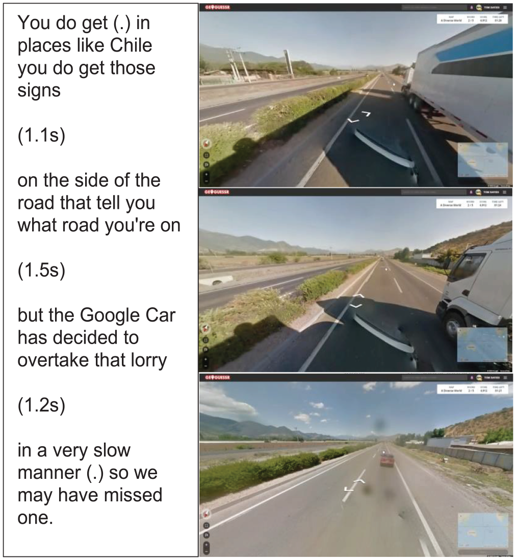
GeoWizard explains the lack of visual access to road signs in terms of the passing speed of the Google Car [VID 6, 5:51–6:03].
These two examples demonstrate how, in the context of particular activities, GeoWizard experiences varying degrees of immersion into GSV. The contingent and limited nature of GSV manifests itself differently depeding on the kind of exploring GeoWizard undertakes. Digital maps have been theorized as interfaces with particular affordances that “invite certain interactions” and even as having their own kind of agency (Lammes, 2017: 1023). In the Geoguessr cases we see how, depending on the task at hand, the interface can seem like a transperent vehicle through which we access the world of GSV, or as a limited system of images constrained by the maneuvering choices of a Google Car driver. The latter sense of GSV as a set of images contingent on the material infrasture through which they were captured, while deflating to the sense of immersion in a “world” of GSV, provides additional meaning for GeoWizard in his efforts to make a guess.
When GeoWizard is able to develop a strong hypothesis regarding his location, he often does so in an area that, because he has moved through the GSV imagery, is remote from the target location in which the round began. He addresses this issue by developing a measuring system to make distances across representations comparable. In one example, shown in Vignette 6, GeoWizard attempts to count the dashed centerline segments, which he calls “dots.” Meanwhile, he is careful to keep his mouse “in the same position” on the display in order to consistently load the next image captured by the Google Car without skipping any images. A few moments later, during the same round, the dashed centerline becomes a single solid line, so the “dots” that GeoWizard was counting are no longer available as a unit of measurement. He continues counting the clicks of his mouse, though (Vignette 7).
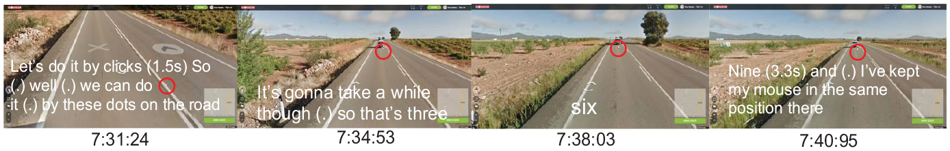
GeoWizard counts the dashes in the center line and his clicks, each of which is made in the same mouse position. Red circle added to show mouse position circled in red [VID 14].
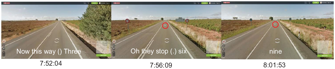
GeoWizard realizes the center line is no longer dashed, but continues counting clicks, carefully maintaining the same mouse position. Red circle added to show mouse position [VID 14].
This strategy is based on the knowledge that the Google Car cameras produce images at regular temporal intervals, so the spatial distance between available images will be consistent as long as the car maintains a single speed. He notes how many “clicks” it takes to get from one end of the stretch of road to the target location, and also how may clicks it takes to cover the entire stretch of road. He then makes a guess on the map based on the proportion of clicks to reach the target and clicks to span the whole road. If the whole stretch of road is 9 clicks long, and it takes only 3 clicks to get to the spot on the road that is the target location, then he makes a guess one-third of the way down the road as it appears on the map.
The choice between counting the dashes on the road and counting “clicks” reflects the distinction between the Geoguessr subject as immersed in the virtual world presented by GSV, and the Geoguessr player as aware of the mediating apparatus of Google Car that is constrained by the practical reality of capturing images. Just as the car becomes conspicuous as it sluggishly overtakes a large truck, it becomes conspicuous here as GeoWizard makes use of the Google Car’s camera technology to measure space. The contingent, material and limited nature of the GSV data serves, in this case, not as a barrier to immersion, but as a tool to make the GSV representation more compatible with the map. Through attention to the material circumstances by which the GSV imagery was produced, GeoWizard extends this representation by measuring distances.
While there is much debate about whether digital maps are transparent windows into the world or contingent, dynamic, and material assemblages, these aspects do not characterize GSV a priori, but are rather both strategically evoked to, in the case of transparency, give the impression that “we fit through the gap” or, in the case of contingency, use the speed of the Google Car to measure distance. In the latter case, the task of manipulating GSV images to make them intelligible alongside the digital map inspires a novel use of the interface that yields a new measuring system and new understanding of distances between places.
Peirce’s abductive diagrammatic inference in reasoning and in play
Seen semiotically, the challenge of making a guess in the game of Geoguessr requires a particular manipulation and transformation of the two available representations. Both GSV and the Google map can be described as icons according to C.S. Peirce’s triadic taxonomy of signs. Peirce’s triad of sign types includes icons, which represent by similarity, symbols which do so by rule or convention and indices, which do so by pointing or directing to the object. Geoguessr representations are icons because they represent their objects, places, roads, features etc., by virtue of similarity. Peirce further distinguishes icons from the other classes of signs by the fact that only icons can be manipulated such that they yield new knowledge—a process which, in the case of the iconic signs of Google maps and GSV, takes place at the computer interface. The premise of the Geoguessr challenge is reflected in an example Peirce uses to explain the icon: “a great distinguishing property of the icon is that by the direct observation of it other truths concerning its object can be discovered than those which suffice to determine its construction. Thus, by means of two photographs a map can be drawn” (Peirce, 1994: 2111 §2.279).
The map is a common example of a particular kind of icon, the diagram, which is characterized by its expression of the relations between components of the object it represents. The map available in Geoguessr is no different from the maps used frequently in Peirce’s examples: it shows a top-down picture of an area as well as the relations between towns and roads. GSV imagery, on the other hand, is most obviously classified as a Peircian “image,” another kind of icon which is distinguished by its sensuous “simple qualities,” rather than schematic resemblance. However, in the context of the practical manipulations of game play, the diagrammatic component of GSV imagery becomes clear:
As soon as you judge fore-, middle-, and background and estimate the distance between objects depicted in [a] pictorial scene, or as soon as you imagine yourself wandering along the path into the landscape, you are operating on the icon—but doing so in this way is possible only by regarding it as a diagram. (Stjernfelt, 2000: 360)
The strategic manipulations GeoWizard performs on GSV imagery constitute this kind of diagrammatic reasoning, such as when GeoWizard invites the viewer to imagine, along with him, the prospect of “fitting through” a narrow alleyway (Vignette 4).
Diagrammatic reasoning, as is sometimes exemplified in geometric diagrams which plainly demonstrate a mathematical principle, can take the form of showing, or making clear through a manipulation of the diagram (Peirce, 1976: 318). This kind of showing is best illustrated in Vignette 3, in which GeoWizard manipulates the map, gestures with the cursor and moves through GSV images so as to investigate for himself and demonstrate to the viewer the ways in which the map and the Street View could be seen as the same place. It is through transformations of diagrams that GeoWizard comes to see the small village photographed by the Google Car in Vignette 3 as the village of Smedsbyn which he sees labeled on the map (Eco, 2000: 125; Peirce, 1994: 3791 §5.181). As has been observed in other semiotic studies, the transformations of diagrammatic inference results in a conclusion of self-similarity: “The Schema sees, as we may say, that the transformate Diagram is substantially contained in the transformand Diagram, and in the significant features to it” (Peirce, 1976: 318; see also Pareyon, 2010; Stjernfelt, 2000: 372). The Geoguessr task is not simply to take the Street View scene as input and produce a point on the map as an output, but to manipulate both representations so as to see the target location as a particular place.
Geoguessr requires players to focus on one representation, either the GSV images or the map, and use clues from the other for guidance or context. This process happens iteratively, alternating between the two representations (e.g. Vignette 3). Having established the semiotic basis on which GeoWizard sees one representation of a place in the context of another, we now turn to the notion of abduction to explain how it is possible to switch focus from one representation to the other and thus iterate this technique. Abduction is a form of inference that Peirce describes, in contrast to induction and deduction, as “a method of forming a general prediction without any positive assurance that it will succeed either in the special case or usually” (Peirce, 1994: 2105 §2.270, for an example of abduction described as “guessing” see 1994: 4543 §7.219). The unsettled nature of the guess is part of what distinguishes abduction from other forms of inference (Peirce, 1955: 154). Having either found enough clues in the GSV images to venture into the map or the other way around, GeoWizard takes an abductive leap of faith into the other representation.
Conclusion
Through the process of diagrammatic inference, various ways of conceptualizing the Geoguessr representations emerge, all in service of making an accurate guess. As is shown above in the example of the click-based measuring system (Vignettes 6–7), the immersive understanding of GSV may give way to one that emphasizes the material and contingent nature of GSV images, which has recently been highlighted in social scientific analyses (Gibson, 2014; Lammes, 2017). This insight also speaks to a similarly relevant topic of the map-interpreting subject (Gilge, 2016; Lammes and Wilmott, 2020: 203). The “I” or “we” of GeoWizard’s subject position changes as he engages in strategies that align with a sense of immersion in the world of GSV, and others that draw attention to the constructed and limited nature of these representations. This contradicts the notion that immersion into an embodied reality of the interface makes an awareness of the constructedness of the map impossible and thus “if the map were acknowledged as creating the boundaries rather than representing them, it would no longer function as the tool that embodied reality” (Farman, 2010: 879). With a focus on practice, questions about the constructedness of cartographic representations and the role of the user no longer appear as a priori qualities of the interface, but rather aspects that come and go as activity progresses.
While this description of the inferential process seems to attribute much of the guessing process to GeoWizard, the diagrams themselves, which reflect the relations of the thing they represent, also play a fundamental role in this process. The transformation of diagrams, according to Peirce, “not only happens in the cortex of the human brain, but must plainly happen in every QuasiMind in which Signs of all kinds have a vitality of their own” (Peirce, 1976: 318). The extension of the semiotic process beyond the player is exemplified in Vignettes 6 and 7, in which GeoWizard actively engages the GSV imagery, relying on the structure of the representation to make a distance judgment. What Peirce here refers to as “vitality” has been described in cultural geography as agency: “interfaces have agency in how meaning is produced and are not just representing visual and spatial information . . . they invite us to make specific translations that call both the landscape and the map into being” (Lammes, 2017: 1023). By attending to the activities by which the Geoguessr subject and digital mapping representations are brought into relation, agency reveals itself not as a static quality of either the interface or the user, but rather one that manifests in various ways in different moments of the Geoguessr process.
The interest that Peirce takes in diagrammatic inference as a way of gaining new insight through the manipulation of an iconic sign may constitute an explanation for GeoWizard’s efforts, described above, to minimize the number of road sign–based map searches and digitally speed them up when they feature in his videos, as these searches do not feature multiple iterative diagrammatic inferences. While it is hard to know if the complexity of the inferential process outlined above is what makes GeoWizard’s videos entertaining, his intuition to value this kind of inference reflects the fact that is at once both a kind of reasoning or problem-solving and also a form of play.
In a discussion of the important processual and performative aspects of locative media and navigational interfaces, Lammes and Wilmott (2020) investigate some conspicuous intersections between mapping and play, suggesting that “the playfulness of [mapping] interfaces is intricately connected to their mobility and interactive transformability, as such interfaces invite users to visually move, perform and play with them. . .their playful agency is related to their ambiguity” (p. 205). More than a general transformability, the present analysis specifies a particular kind of transformative inferential process. The ambiguity the authors mention, which they go on to explain with the example of a bridge that could become meaningful in multiple different ways, is a result of this process and is enabled by the uncertain abductive leap required to iteratively infer about the diagrams of the map and the GSV imagery. The role of abduction in Geoguessr gameplay accords with the theoretical notion, common in the field of game studies, that play cannot be exhaustively described by the rules or equipment of the game, but instead is constituted only through practices in which game equipment and rules are continually repurposed and reinterpreted (Hughes, 2006).
The abductive guess required to move between these two representations also constitutes a component of play that unites it with reasoning and problem-solving. Play has long been theorized as essential in the processes and development of cognitive skills (Smith, 1982). In the case of GeoWizard gameplay, abductive inferences constitute much of the entertaining challenge of the game. Seen in terms of the dynamics of Peircean semiotics, the process becomes comparable to abduction as it has been theorized as a process of visual communication and other cognitive tasks (Moriarty, 1996; Shank, 1998).
Beyond this preliminary analysis of the practices of Geoguessr, further work is needed on topics including signification of cultural difference and how cultural signs, race, and imperialism emerge from the practices and structures of the activity. In another direction, the analysis could be extended by showing how the Geoguessr task structures the performance in which GeoWizard presents himself as a YouTube content creator, following, for example, Zile and Lanson’s (2020) discussion of “platform poetics.” The practical orientation of this study is compatible with further inquiry into how GeoWizard’s talk, gesture and other communication strategies are not simply representative of his thoughts or attitudes, but rather a dynamic performance through which novel places and concepts emerge.
Footnotes
Appendix
Videos analyzed.
| ID | YouTube code a | Title | Duration | Views b | Upload date |
|---|---|---|---|---|---|
|
|
6MgJWoWYDLs | Perfect score on Geoguessr (World Version)—30 minutes 5 seconds! | 31:36:00 | 3,047,154 | 28 April 2016 |
|
|
MSm-UJKNpRg | My first attempt at a sub 20-minute diverse world perfect score. . | 29:33:00 | 310,434 | 20 May 2020 |
|
|
qA3-VKYvWds | Perfect score on Geoguessr “A Diverse world” in 31.42 | 33:52:00 | 341,933 | 12 November 2018 |
|
|
pF9OA332DPk | Geoguessr - 3 Minutes Per Round (A Diverse World) [PLAY ALONG] | 22:07 | 37,703 | 10 May 2019 |
|
|
edyfrpMAeOE | Geoguessr - 3 Minutes Per Round (A Diverse World) #2 [PLAY ALONG] | 19:54 | 62,513 | 23 October 2019 |
|
|
edPiYaSZvx0 | Geoguessr - 3 Minutes Per Round (A Diverse World) #3 [PLAY ALONG] | 17:38 | 80,471 | 20 March 2020 |
|
|
EAoVoLtzovk | Geoguessr - 3 Minutes Per Round (A Diverse World) #4 [PLAY ALONG] | 18:47 | 71,237 | 27 March 2020 |
|
|
rHmy3rNndAc | Perfect score on A Diverse World in 22:49 **streamed live** | 23:47 | 132,386 | 24 May 2020 |
|
|
B5ZFNb99klc | A Perfect Score on “A Diverse World” in 17:31 | 20:37 | 243,988 | 26 July 2021 |
|
|
4ynyB8OacfA | Perfect score on “A Diverse World” In 13:24 [New PB] | 15:49 | 372,803 | 4 August 2021 |
|
|
mFy7k6HtQew | Geoguessr lessons—Long and straight roads! #1 | 10:08 | 43,709 | 28 February 2018 |
For video URL, add “www.youtube.com/watch?v=” before the code.
View counts as of 2 April 2022.
Funding
The author(s) received no financial support for the research, authorship, and/or publication of this article.