
Abstract
A closer look into the history of maritime geomedia reveals a historical intermezzo in which navigation in cases of unstable sight was realized with “Submarine Signaling” (SS). This infrastructure for the purpose of safe wayfinding along coasts operated from around 1900 to the early 1920s, relying upon submarine bells in the global oceans, and hydrophones and telephonic user interfaces in vessels. SS can be regarded as a starting point to the era of electrotechnological navigation, and is of media-historical interest insofar as its operability was based on undersea acoustics: shifting its epistemic focus from sight to sound, SS thus lay beyond the “visual regime” that characterizes our current digital geomedia cultures. Herein, I will reconstruct the genesis and history of SS, use it as a contrasting foil to our postmodern geomedia practices, and finally argue for an understanding of geomedia as historically variable phenomena.
Keywords
Introduction: sounding (out) geomedia
Current geomedia research tends to put a strong emphasis on contemporary geomedia and their practices. This is not surprising insofar as our present-day digital cultures are per se distinguished by space- or location-aware media technologies that, for example, locate users within digital maps using global navigation satellite systems like the Navstar GPS, overlay physical spaces with additional digital data—all forms of augmented reality, culminating in virtual reality—or allow for a remediation (Bolter and Grusin, 1999) of spaces and places in digital media, thus establishing a strong correlation between geography, technology, and their infrastructures (Sheller, 2017). However, it should be desirable to epistemologically and historically ground this kind of “present-mindedness” in the discourse—to apply to geomedia studies a term coined by Harold Innis (1951)—to understand the historical tradition of geomedia and thus to be able to characterize the signum of our postdigital (Negroponte, 1998) geomedia cultures in contrast to geomedia and their practices in history.
As a consequence of the spatial turn in media studies, and a media-cultural turn in geography, there has been increasing interest in the interconnections and entanglements of media technology and geography. The nexus between geography and media becomes even more evident when it comes to questions of navigation. From a geomedia standpoint, the history of navigation is even more interesting since it has always been a mixture of geography and media, videlicet territorial wayfinding on the basis of intermediaries that mediate between territory and position through charts; digital maps; analogue instruments, such as sextants, compasses, and chronometers; or elaborate technologies, such as radar, GPS, or sonar.
This article is concerned with analogue navigational media which are commonly not regarded as geomedia: underwater bells, underwater microphones—hydrophones—and telephone receivers as user interfaces. In their specific interconnection and practical usage, these technical devices became geomedia in the case study of this article, “Submarine Signaling” (SS), which denotes not signaling underseas in general, but an infrastructure for maritime wayfinding in situations of unstable sight when visual navigation was not possible any longer. Here, the telephone has been used not as a medium for bidirectional verbal communication, but as a unidirectional geomedium that translated the problem of maritime wayfinding into hearing operations through communicating geoinformation aurally. The interesting aspect about SS is that, on one hand, it has been a first technological geomedia infrastructure, since its efficiency based on user interfaces and transmission electronics to communicate geoinformation in real-time, and thus, it can be regarded as a starting point for the era of postmodern navigation. On the other hand, SS, although forgotten today and outdated for decades, is the first widely practiced and successful geomedia infrastructure that operationalized the human sense of hearing for the purpose of safe wayfinding.
In the following, I will historically reconstruct SS as geomedia technology, infrastructure, and practice. First, I will unfold the maritime navigational context of around 1900 that made SS desirable. Second, I will investigate the media technology involved in the process of enabling navigators to find their way through geographic territory within this infrastructure and its technologically constructed (acoustic) spaces. Then, from a media practice standpoint, I will elucidate the epistemic shift that went hand in hand with the switch from conventional to acoustic navigation. Because SS had already become technologically and practically outdated by the 1920s—hence, a “dead medium,” in the sense of Bruce Sterling—it is also worthwhile to investigate the reasons for this. Taking a media archeologically influenced retrospective view toward an infrastructure that failed to stand the test of time helps to identify what characterizes our modern understanding and practice of geomedia and navigation. According to this assumption, I will utilize SS as a contrast to our postmodern geomedia technology. I will argue that this case study can be regarded as lying beyond what Nana Verhoeff (2012) calls the “visual regime” of our culture, and that geomedia, in their presentness and historicality likewise, should be understood rather as phenomena: on one hand, as artifactual and practiced representations of spatial conceptions and assumptions that lie behind them, and for which they are indicators, and, on the other hand, as index for the epistemic condition of science and technology at their individual time of emergence. That is to say, geomedia appearance and practice takes place against the backdrop of history, especially the history of science and technology. This strengthens my argument to understand geomedia as historically variable phenomena which are reluctant to definitions that do not take their historical situation into account.
In line with this, it could be helpful not to too narrowly define geomedia, namely, only in relation to nowadays technological condition, which is a digital media culture with smart devices which are infrastructurally interconnected. Interlacings of territory and media, the boundedness of technology and geography on each other, have roots that predate digital cultures. A more inclusive definition of geomedia could thus name technological referencings of geography and, vice versa, geographical referencings of technology—be it for purposes of navigation, mapping, measuring, surveillance, and so on—which depend on the individual historic situation of science and technology and which intervene in the assumption of space and media as a given, but rather as something practiced, socially and culturally learnt, politically regulated, and technically formatted likewise. This has consequences for the study of geomedia and their history as this article will show by means of a case example that actually has been a geomedia infrastructure albeit it resists current definitions of what geomedia are.
It should be noted in advance that SS is an academic desideratum, of interest for the history of acoustics and the history of technology, as well as from the perspectives of (geo)media, communication, sound, and cultural studies. The leading academic in the field of underwater acoustics mentions SS only briefly in reconstructing the prehistory of sonar (Hackmann, 1979, 1984, 1986) as do Elizabeth Bruton and Paul Coleman (2016) in their history of submarine audio technologies during the First World War, as do Gary Frost (2001) and John Shiga (2013, 2015, 2016) in their work in this respect. However, besides a short presentation (Howarth, 2015), no researcher has focused on SS exclusively. What the researchers into SS hitherto have in common is that their interest has been mainly concerned with the involvement of Reginald Fessenden, beginning in 1912, with the outcome of the so-called Fessenden Oscillator: a first prototypical sonar device for transmitting and receiving acoustic underwater signals. My aim here is rather to historically reconstruct SS as a navigational geomedia infrastructure.
This article further situates itself within the oceanic turn in current humanities for which Melody Jue (2020: 16) recently applied far-reaching names, such as “ocean humanities,” “blue humanities,” or “thalassography.” While geomedia research focuses commonly not only on contemporary developments, but also on geomedia on shore—as McQuire (2016) programmatically did—this “going to sea” of geomedia research may allow for a decentralization of “dry land” geomedia studies. In so doing, it becomes evident what Stefan Helmreich (2016: 186) meant when stating “the medium of water needs to be theorized not just as an ambient surround, but also as a medium through which living and knowing happens,” since geomedia investigations within the fluid and literally immersive medium of ocean water offer different epistemic interpretations of human and non-human actors and their sensory skills in wayfinding practice.
Unstable sight: when the eye fails
In 1929, the ‘‘Idaho’’ became stranded on the coast near a missed port entrance in Aberdeen, Scotland, because of precarious viewing conditions in a thick fog (Figure 1). The ship’s navigator was not able to safely find the way into the harbor since he could not rely on his visual knowledge of how to steer a ship, nor could he trust his eyes in realizing unerring wayfinding. This example is just one of many that proves to be programmatic for the problem of navigation, especially since the 19th century when the global marine trade and passenger shipping expanded massively as a result of engineering progress in the shipbuilding industry. Artificial visual aids to navigation near coastlines, such as lighthouses or beacons to warn navigators of approaching dangers, may have a comparatively long history in itself (Stevenson, 1932). However, they often proved to be disappointing or even useless in thick fog.
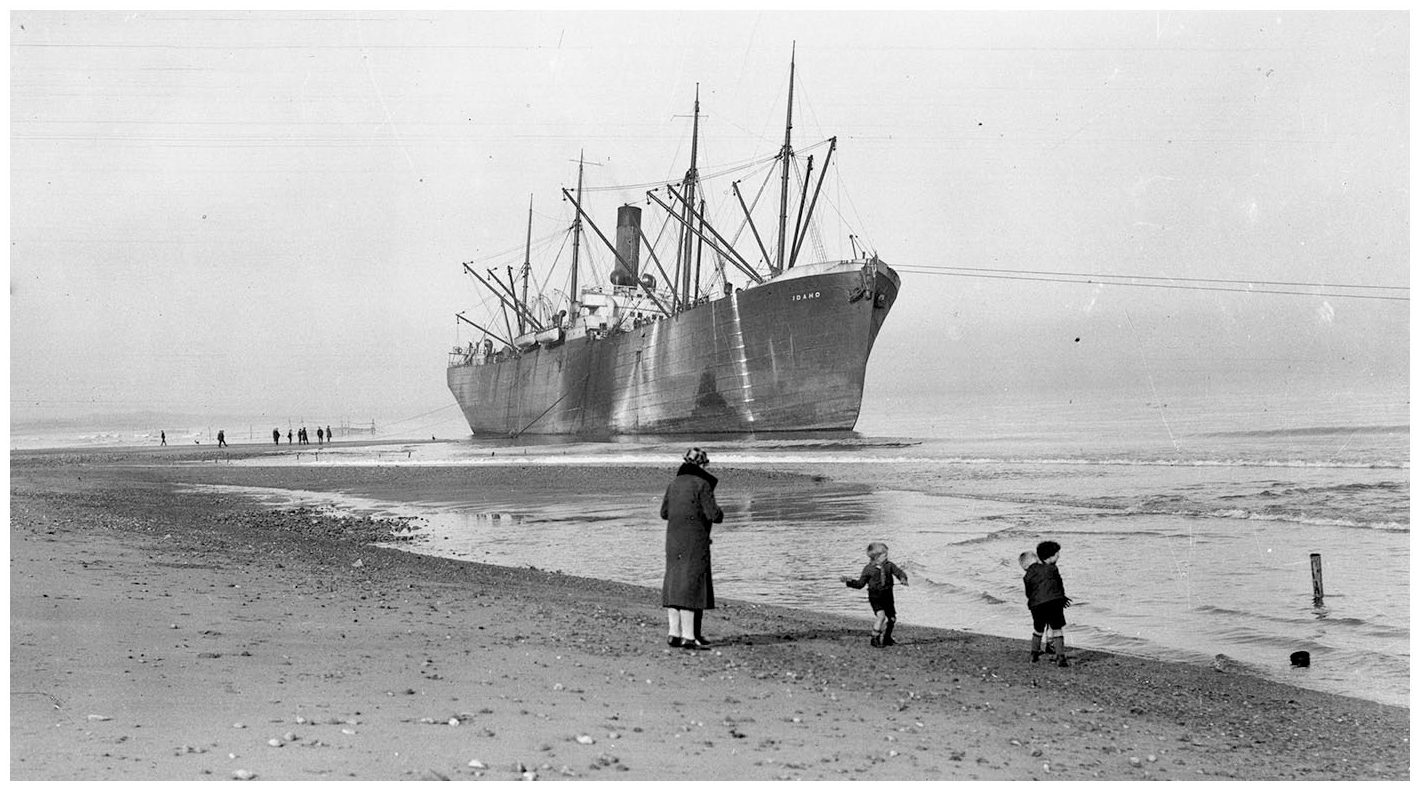
The vessel ‘‘Idaho’’ at Aberdeen Beach in Scotland, stranded after missing the harbor entrance because of fog (Begbie, 2017).
In contrast to the high seas, where fog presents itself not as much as a problematic natural phenomenon for navigation as near shore, in approaching the coast it turned out to be a most dangerous disturbance of the usual practices of wayfinding. Physicist John Tyndall (1874: 183), for example, reported to the Royal Society of London that in the years between 1864 and 1874, 273 vessels were lost alone along the British coastline due to fog and unstable viewing conditions. Another source stated that, globally, between 1893 and 1902 approximately 1000 vessels ran aground due to fog, causing financial damage of about US$57,000,000 and a loss of 530 human lives (Sawyer, 1914: 115). Thus, not only commodities, but also human lives proved to be property worth protecting within the maritime shipping context.
After the conceptualization of some early fog gun prototypes during the 18th century, installation of aerial acoustic fog signals intensified in the 19th century with fog horns, steam whistles, fog sirens, and bells. Despite these efforts, aerial fog signals appeared to be untrustworthy, ironically precisely because of fog itself. As a result, practical experiments with fog signals were prominently conducted between 1860 and 1880 by John Tyndall, on behalf of Trinity House, the British lighthouse authority, in England; and by Joseph Henry, who was authorized by the US government. Both eminent researchers independently concluded that aerial fog signals were absolutely impractical since they were reflected or refracted by layers of air of different density, creating zones of silence—acoustic shadows—and possible echo zones (Henry, 1879, 1886; Tyndall, 1874, 1878). In line with this, aerial fog signals in maritime practice proved to be so useless that they evoked misleading auditory impressions that caused beachings once again (Higginson, 1914: 420). The common knowledge about aerial fog signaling could thus be summarized in retrospect as follows:
The Mariner should not assume:
(a) That because he fails to hear the sound he is out of hearing distance.
(b) That, because he hears a fog-signal faintly, he is at a great distance from it.
(c) That because he hears the sound plainly he is near it.
(d) That, because he does not hear it, even when in close proximity, the fog-signal has ceased sounding.
(e) That the distance from and the intensity of the sound on any one occasion, are a guide to him for any future occasion. (Joly, 1918: 2)
The sole, undesirable solution for protecting loaded commodities and human lives against running aground in coastal fog consisted of anchoring until a fog lifted. For bigger vessels, this could cause financial losses due to shipment delays in the range of US$500–US$4000 per hour per vessel (Wilhelm, 1922: 249). Another source gives similar numbers when stating that anchoring in front of harbor entrances could effect a US$50,000 loss per vessel per day (Blake, 1916: 204). Accordingly, within the context of the 19th and the early 20th centuries, it is fog that has been narrativized as the greatest enemy of navigators since it made existing navigational tools for wayfinding by sight—such as octants, sextants, hydrographic charts, compasses, and binoculars—inapplicable, and therefore, useless:
Of all the perils which attach to ocean navigation the most paralyzing are undoubtedly those caused by fog. No type of ship is immune from its terrors, and the larger and faster the vessel the greater the menace. Every ship captain is well aware that impending death and disaster lurk for him in fog, though his vessel be one which under ordinary, or even extraordinary conditions of wind and wave, is practically superior to all dangers. [. . .] [F]og takes away his eyes and filches from him the sure dependence on his ears which he has in clear atmosphere. (Scientific American Supplement, 1915: 168)
Accordingly, finding a way to realize safe coastal navigation in cases of unstable sight became a most desirable need and a crucial issue. In 1889, in an effort to secure greater safety at sea, the International Marine Conference attempted to address the problem of ships’ collisions in fog, but came to no efficient technological solution (Brooks et al., 1889). Because of the unreliability of aerial fog signaling, contemporary literature attested that fog was indeed the final technologically insurmountable problem facing navigation at the end of the 19th century. Through progress in marine engineering, storms no longer constituted any menace, fires on ships seldom caused the losses of vessels, older wreckages were systematically destroyed, lighthouses were positioned at dangerous points, and coast lines were exactly charted, yet fog still remained unconquered (Lynch, 1922: 469; Perkins, 1914: 29). As the Scientific American Handbook of Travel stated: “More difficult and dangerous becomes the navigation of a ship at times when there is a dense fog, since then obstacles are not visible until it is too late, and a collision or stranding is unavoidable” (Hopkins, 1910: 159). In other words, it became evident that for fog signals, a transmission medium other than air had to be found to maintain maritime wayfinding at times of unstable sight.
Submerging research: fluid transmission media
While the Scientific American Handbook of Travel attested air to be inadequate as a transmission medium for acoustic signals, the more appropriate medium to act as a natural channel for transmitting sonic signals was determined to be the literal carrier medium of seafaring: seawater itself. As Hopkins (1910: 210) noted, water is a “less mobile medium than air, less responsive to marked variations of density arising through changes in temperature and pressure, and, therefore, less subject to variations of homogeneity and more reliable as an agency of the transmission of sound waves.” Since the eminent experiments of Jean-Daniel Colladon and Charles-François Sturm in the first half of the 19th century, it was commonly understood within the scientific community that water is “an excellent sound medium, and does not appear to suffer from the acoustic clouds and erratic reflections found in air” (Sawyer, 1914: 117). However, throughout the 19th century, this remained sheer theory and did not crystallize in any practical form. Lucien Blake, Professor at the University of Kansas, was the first person to formalize the idea of using underwater sound, originating from underwater bells, to receive via microphones in vessels, thus implementing fog signaling into the ocean, and in doing so, constituting the sea itself as “the transmitting medium” (Marine Review, 1904: 21). His idea, however, resulted only in a patent, with no functional system at all: his patent specification, despite being the first writing to use the term “hydrophone” for underwater microphones, stated that “No Model” existed (Blake, 1889).
Some years later, Arthur J. Mundy, supported by Elisha Gray, conducted experiments with underwater sound at Mundy’s waterfront home on Cape Ann, Massachusetts. Financial support for those early experiments was secured from 1899 on by Josiah Byram Millet, who was connected to the American industrialist Henry Melville Whitney. Unaware of Blake’s first research into the operationalization of underwater sounds for navigational purposes, Mundy suggested—as Blake had before—the use of underwater bells and underwater microphones distinct from conventional aerial microphones. Gray, a respected telecommunications engineer and co-inventor of the telephone, was aware of the differences between air and water as transmission media, and suggested positioning the microphones underwater, in a metal case used as a shielding, attached to a thick di-aphragm. This diaphragm carried a kind of button that could be moved to vary the current in an electrical circuit that included a battery and telephone receivers, which made this moving action audible. In this, Mundy and Gray formalized a transducer to convert the vibrational force of underwater sound in varying electrical currents which could then be made sonic again via telephone receivers (Fay, 1963: 8). Though it was Blake who first coined the term “hydrophone,” it was Mundy and Gray who actually built the first prototypes of such as well as underwater bells, and who got also a patent for their invention (Gray and Mundy, 1899).
In 1901, Mundy, in collaboration with Millet and Edward Wood, acquired Gray’s patent rights for this principle and founded the Submarine Signal Company (SSC) in Boston. Insofar as they intended to use subsea acoustics for practical navigational instead of purely scientific purposes, as Sturm and Colladon did before, this marks the outset of the commercialization of underwater sound. In formalizing the future possibility of acoustic navigation in situations of fog, two aspects proved to be especially crucial. First, the very positioning of the hydrophone inside a ship was problematic in that a sufficient signal-to-noise-ratio had to be established to be able to aurally differentiate between signals of underwater bells, on one hand, and the noise of the marine engine and the sound of the sea itself, on the other. Mundy and Millet found the solution to the problem of noise cancelation in placing the underwater microphones in a water-filled tank inside ships, attached to the ship’s hull. In this way, sound signals would pass through the metal hull of a ship, while the residual noise of a ship did not greatly affect the microphones. Second, since human directional hearing does not work when submerged underwater, a technical solution had to be found to the problem of deciding from which direction a submarine signal from an underwater bell came. Following the principle of human directional hearing which is realized through two ears instead of one, Millet and Mundy worked out a principle that made use of two ship-sided technical ears, namely, two microphonic tank-units to receive underwater sound. If these were positioned inside ships below their water line starboard and port side, respectively, the underwater sound was received louder or quieter, corresponding to a ship’s direction in relation to the position of an underwater bell. To determine this, and thus enable wayfinding on the basis of volume comparison, an auditory, telephonic interface (see Figure 2) had to be constructed to switch back and forth between both receivers to compare the loudness of the signals originating from an underwater bell. If the sound originated on starboard side, the sound from the starboard receiver was heard more loudly through the telephone, and vice versa, since a ship’s bow functions like a sound barrier (Figure 3).
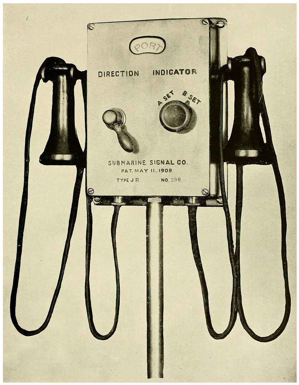
A 1914 illustration of the interface for navigating with submarine signals. The switch on the left side was used to determine whether to telephonically listen to the port or starboard hydrophone. Since two devices were in each hydrophone tank, so that navigation could be realized even if one hydrophone was defective, the switch on the right-hand side differentiated between an “A” and a “B” set of hydrophones. The interface was usually located on the navigating bridge where the navigator operated (Millet, 1914: plate 44).
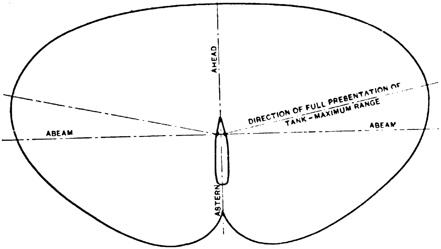
Schematization of the principles of aural navigation with SS: if an underwater bell was heard louder through the starboard receiver, the bell was on starboard, and vice versa. If the volume was of equal loudness, regardless of which hydrophone was listened to, the bell was dead on. A bell was astern if its signals were heard only faintly (Fay, 1912: 1350).
Early contemporaries of the system acknowledged that in its appearance, the SS user interface was not a totally new technical device. One witness stated, for example, the “Gray-Mundy apparatus looks much like an ordinary house telephone” (Marine Review, 1904: 21). It must be noted, however, that the specific formalization of the interconnection of hydrophones and telephone receivers created a media setting in which the telephone did not allow for verbal communication between spatially distant actors. As a listen-only device, in serving the purpose of proving relative underwater positions aurally, the telephone became a geomedium for navigation. Rather than conceptualizing communication and navigation media as discrete categories, one might argue that they overlap here in the case of the SS user interface since it adapted the telephone to ocean navigation. Navigational media might be therefore understood as a special type of communication media wherein the message encodes locational data and is, in this case, transmitted to those close to the relevant location, as has been the case in the coded signals of underwater bell stations. And because this undersea technology and scientific knowledge hardly existed when Mundy and Gray started their research into underwater acoustics, they should be regarded as pioneers in “submerging (geomedia) research.”
Net-working acoustic spaces: infrastructuring and capitalizing underwater sound
The founders of the SSC fundamentally acknowledged that the
crude idea of transmitting sound signals under water would have little value unless backed by expert knowledge, business ability, and financial strength, and proceeded to form a syndicate for developing the invention, thus entering upon its [. . .] stage of commercial development.
Attested Harold J.W. Fay (1912: 1341), a later President of the SSC. And at this historical point of SS, “the hard work had only begun,” as the same Fay (1963: 10) reflected much later. Technologically, formalizing and building prototypes for SS created neither an infrastructure for its usage nor acceptance by navigators. To actually carry out maritime navigation in fog as a mediatized telephonic hearing practice, and to transform SS into a commercially successful navigational aid, it needed: (a) a network of underwater bell stations, (b) their symbolic cartographic representation to identify the coded signals of individual bell stations to georeference them, and (c) comprehensive promotional efforts by the SSC to sell their equipment.
These different elements of evolving SS into a widely practiced and commercially profitable infrastructure were intertwined, as it would have been more difficult to convince skippers to pay for the SS equipment when there were only sparse underwater bell stations installed globally, and vice versa, as it was difficult to expand the network of bell stations if nobody was willing to pay for the equipment to use these for navigation. Fay (1963: 10) commented on this matter in retrospect, that
[t]he first equipment developed was received with skepticism by skippers. They felt the equipment to be of little use when there were but a few bells installed. Lighthouse boards likewise felt it was impractical to install bells at danger spots when ships had no listening apparatus.
The paradoxical situation that the SSC faced was that despite having devised a new practical technology for navigation, there was not anybody to use it. To find their way out of this quandary, rather than selling their first underwater bells to governments, the SSC but loaned them to the US Lighthouse Board, installed them at their own cost, and even paid men to operate them. Four lightships between New York and Boston harbor were equipped with bells: “Pollock Rip,” “Hen & Chickens,” “Nantucket Shoals,” and “Boston.” For the receivers, Henry M. Whitney—who was then both president of the SSC and operator of the Metropolitan Line that served the route between Boston and New York—equipped four of his vessels with these instruments in 1904. These first installations were followed by a large testing, carried out by the US government in June and July 1906, with continuous bell ringing at five bell stations between Boston and New York at day and night, proving whether or not SS could become a state-approved aid to navigation. The system turned out to be effective: the underwater bell signals could be heard through the SS interface at a maximum range of between 6 and 12 miles under normal conditions, and up to 25 miles under ideal conditions. As early as August 1906, the US Lighthouse Board ordered bell equipment from the SSC for ten lightships. The British Admiralty also made exhaustive tests of SS at their Navigation School in Portsmouth beginning in November 1906, and issued a special report of their approval which highlights the advantage of submarine over aerial fog signaling:
The fog signals at present in use in light-ships in Great Britain cannot be depended on to be heard in all conditions, even at one or two miles distance; and a vessel, failing to make the fog signal out, may be on a safe course and in her estimated position, yet she must stop or anchor or alter course out, because she is uncertain. The Submarine Bell increases the range at which the fog signal can be heard by a vessel until it approximates to the range of a light-vessel’s light in clear weather, and, moreover, its bearings can be determined with quite sufficient accuracy for safe navigation in fog from distance far beyond the range of aerial fog-signals, if the vessel is equipped with receivers. (cit. a. SSC, 1907: 54–55)
Due to the effectiveness of these ongoing, on-board field tests and subsequent reporting about it in maritime journals throughout the world, SS became known within the maritime community and in return, this provided the base for expanding the infrastructure in, for example, Canada and Germany. In a 1907 company brochure, the SSC (1907: 6) describes how it is already possible for a navigator of ocean liners to arrive at the east coast of the United States, “get his bearings at Nantucket Shoals and proceed to New York harbor, all by the sound of the bells coming to him through the water.” And one of the first German transatlantic liners to be equipped with the receiving apparatus for SS, the “Kaiser Wilhelm II,” practically illustrated that SS’s usage was not confined to saving life and property, but an equally important commodity, from a commercial perspective: time. When SS was still in its early stages of development, a number of other ships which were not equipped with submarine sound receivers and the Kaiser Wilhelm II together reached the mouth of the German river Weser, where a submarine bell was placed, on a day with deep fog. Of the numerous vessels, the Kaiser Wilhelm II was the only ship able to pick up the underwater bell of the Weser lightship, and to enter Bremerhaven harbor to discharge passengers and cargo—“twenty-two hours before the weather cleared outside and the other vessels could make port” (Perkins, 1914: 30).
If Edwin Hutchins (1995: 117) understands navigation as an operational chain, “in which representations of the spatial relationship of the ship to known landmarks are created, transformed, and combined in such a way that the solution to the problem of position fixing is transparent,” in the special case of SS these “landmarks” are characterized by a hitherto unknown feature: they are not visible, as were conventional landmarks (Figures 4 and 5). Although the underwater bells were nevertheless surely visible if one were looking for them, these landmarks were, crucially, meant to be heard instead of seen, making them what I would like to call sonic landmarks, or—following a term by Murray Schafer (1994 [1977])—“soundmarks.” This had consequences for the way that the material meanings and logistics of navigation had to be carried out in practice, evoking an epistemic shift in the field of fog navigation. In their Hilfsbuch für die Schiffsführung (Handbook for Navigation, no English translation), Johannes Müller and Joseph Krauß programmatically described the embodiment and new techno-acoustic regime of actually doing fog navigation, namely, as an aural practice:
The observer must as far as possible exclude all noises that could reach his ear from the outside. If possible, always listen with both telephones!
The observer should not listen continuously for a long time, but take small pauses from time to time, otherwise the ear will be tired. (Müller and Krauß, 1925: 88; my translation)

Figures 4 and 5 show two typical stagings of the epistemic shift that SS provoked and its new sensory geomedia address of navigators. The images focus on the practice of listening to the newly implemented techno-acoustic regime, while systematically excluding the possibility of looking outside, which had been crucial to navigators hitherto.
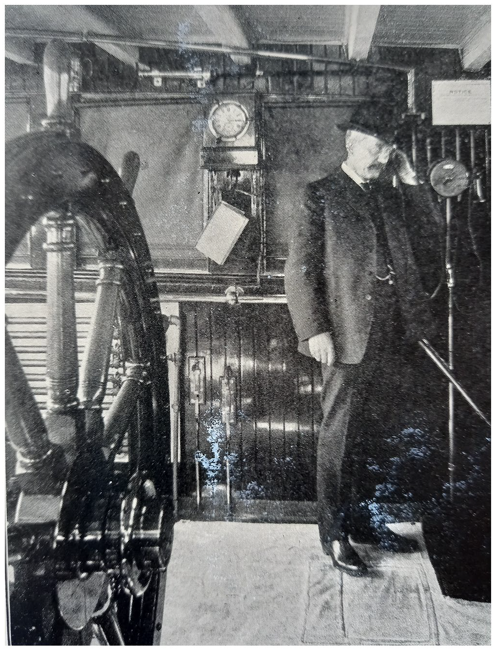
Source: SSC (1907: 59).
Proving the system’s efficacy, by 1907, vessels of the Cunard Line, Hamburg-American Line, North German Lloyd, Holland-America Line, Compagnie Générale Transatlantique, White Star Line, Compañía Transatlántica, American Line, Canadian Pacific Steamship Company, Metropolitan Line, and the Atlantic Transport Line, among others, were equipped with receivers. By 1912, submarine bells were installed along the coasts of the United States and Canada, in the North American Great Lakes, along the North Sea coast and along the coasts of Portugal, Spain, Italy, Brazil, Chile, and China, totaling 138 bell stations across the globe. All of these bell stations transmitted coded signals so that they could be identified on basis of their corresponding number. This global expansion of underwater bells in turn prompted an increase in ships equipped with receivers. While in 1906, not even 200 ships had receivers and acoustic interfaces, as early as 1908, there were about 400; by 1911, about 800; by 1913, about 1000; by 1916, about 1400; by 1918, nearly 2100; and by 1920, more than 3500 vessels were able to sonically navigate the world’s oceans anywhere that underwater bells were placed (Lübcke, 1920: 12). Since the SSC officially asked navigators to send in experience reports, the sonority and “musical quality” (Millet, 1906: 645) now experienced in navigation has been documented broadly. In April 1906, for example, James B. Watt, captain of the vessel “Lucania,” stated:
We had hazy weather with showers of misty rain off the Nantucket Shoals, and we would have failed to locate the light-vessel but for the aid of the submarine signal bell. We heard it 8 1/2 miles distant, while steaming full speed, at 22 knots. We made the light-vessel one point on the starboard bow and passed it 1/3 of a mile off, which enabled us to obtain a good departure. The sound of the bell was musical and distinctly audible, and could not be mistaken for any other sound. (cit. a. SSC, 1907: 13)
In highly frequented shipping areas, the underwater bell network of SS became so closely meshed that it was possible for navigators to steer from the acoustic space of one underwater bell station directly into the sonic realm of the next, as was the case at both the US east coast and the English Channel (see Figures 6 and 7). This geomedia construction of undersea spaces to which navigators listened evoked not only a transformation of geographical territory into acoustic spaces, thus effecting a navigation in and through acoustic territories that were indexically interconnected with geographic ones, but also an aural medialization of space for purposes of wayfinding. One could thus further argue that SS not only implemented techno-acoustic spaces into the ocean but discovered and constructed the ocean as a signal realm in the first place, thereby revolutionizing navigation, as its contemporaries and policy-makers described (e.g. Millet, 1914: 109; SSC, 1907: 6). From a geomedia histories perspective, this is important insofar the claimed revolutionary character of new digital smart devices has a historic index that accompanied also the introduction of SS as a once novel geomedia condition. In an ironic inversion of Friedrich Kittler’s (1999: xxxix) most prominent axiom that “media determine our situation,” one could also argue that, for SS, “media situated determinations”: in this case, sonic determinations of navigation. This acoustic space-making—by means of such comparatively simple and unpretentious kinds of technology as underwater bells connected to buoys, underwater tripods, and lightships—can be regarded as a first endeavor to install a navigational infrastructure that attempts to use electrotechnology to realize safe wayfinding along coastlines across the globe. Although the individual underwater bells were situated locally, their visual interconnection, through the mapping of wide areas, such as the North Sea and parts of the Baltic coast, created a navigational network, and, in this way, a geomedia space of literally far-reaching wayfinding.
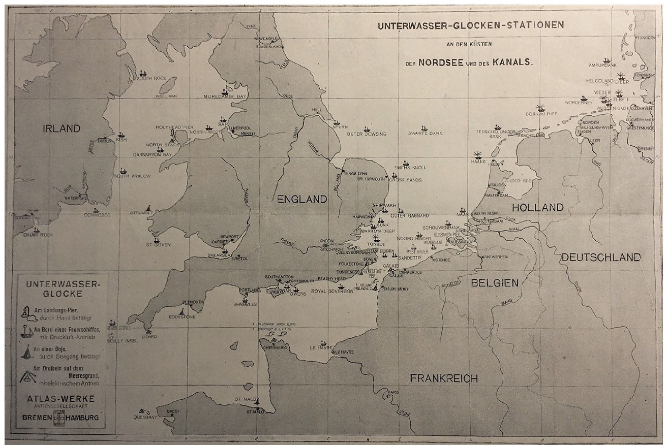
The close-meshed network of underwater bell stations in the English Channel.
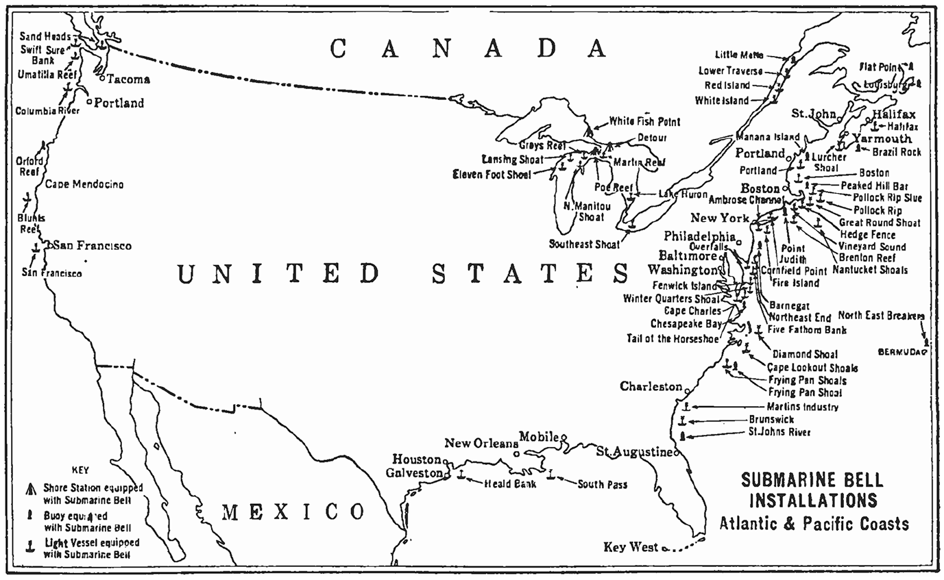
The US underwater bell stations network in use in 1922.
In networking the ocean, the SSC sonically infrastructured, bureaucratized, capitalized, and, finally, technologically organized underwater space. SS did not have a very long history, however. It is not possible to pinpoint an exact date upon which SS ceased to be used in maritime practice, rather, SS became obsolete in the early 1920s with the advent of radio technology, when underwater bell stations were replaced by radio telegraphy to form radio beacon networks. This brought transmission back into the aerial realm, and turned navigation in situations of unstable sight into a solely optical practice again, since fog navigation with radio technology could be realized with the “radio compass” to be directly read off for identifying directions to transmitting stations. In addition, improvements of active sonar technology, which became essential to detect submarines especially during the military conflicts of World War I and II and the Cold War, but which was also of navigational value, made SS obsolete.
More than meets the eye: geomedia beyond the visual regime
As mentioned above, my additional aim in this article is to contrast this infrastructure with the modern understanding and practice of geomedia navigational technology. In our everyday media practice, navigation is—and has always been—circumscribed by a threefold logic of knowing which includes where I am, where I want to go, and how I need to get there. In other words, this can be described as: ongoing determinations of one’s own position (self-locating), definition of a travel destination (an address in the broadest sense, be it a postal address, GPS map data or an otherwise-known territory), and identification of the optimal itinerary. With a phenomenologically invisible data ecology, all of this nowadays is commonly accomplished with screen media.
This is one reason that leads Lev Manovich (2001: 94) already two decades ago to the statement that our society is “a society of the screen,” and Nanna Verhoeff (2012) to the formulation of a “visual regime” for characterizing our current media situation. She notes that, as a result of digital media becoming more and more mobile and connected with our digital media environment that addresses or even privileges the eye more than the ear, we can identify an omnipresence of screens in digital cultures. As a consequence, this screen ubiquity also holds true for the sphere of navigation, which in the most everyday practices is carried out with mobile, digitally interconnected devices as “screen practice” (Verhoeff, 2012: 167). Verhoeff (2012: 13) argues that her proclaimed “navigational turn,” seeming “utterly new, an innovative practice of our time,” is, however, “related to a much older paradigm of relational mobility, which forms a broader cultural logic with historical roots long predating the technology of mobile screen devices.” In other words, the hegemony of visual wayfinding in Western cultures is not caused by screen technology and digital mapping per se, but postmodern technological visual navigation intensifies the cultural supremacy of optical—instead of aural—orientation when it comes to practices of navigation through geographic territory. In accordance with this, Edwin Hutchins (1983) and Hutchins and Hinton (1984) have already illustrated a visual regime when investigating and describing the traditional non-Western and non-screen cultural navigation techniques of Micronesian sailors.
In this article, I investigated an example of a navigational infrastructure whose media and media practices are characterized by neither evoking nor making use of screen navigation, nor does it fit into the “visual regime” at all. On the contrary, SS marks an outstanding historic interlude in the history of navigation wherein sound and the human sense of hearing are the operational basis for the system’s operability and practicality. Both the activities promoting it and the reports describing its use present SS as prioritizing and emphasizing the crucial significance of sailors’ hitherto-subordinate sense of hearing. This, in part, has historic reasons: in the context of the era between 1900 and the 1920s, technological screens, namely, cathode ray tubes, hardly existed; in the 1920s, these were only in use in exclusive scientific environments, mostly as laboratory measurement tools for visualizing voltage characteristics. Furthermore, the technology that is inextricably associated with the evolution of technological screens and from which the very term “display” stems from—namely, radar technology—in its rudimentary formalization dates only to the year 1935, that is, approximately 10 years after SS had already been technologically outdated. The crucial aspect, signum and novelty of SS lies beyond visual prioritization in its substitution of—to seize on Verhoeff’s terminology—visual regimes with aural regimes. Its unique characteristic, or economically speaking, its unique selling point, is its acousticality of maritime wayfinding in cases when visual navigation regimes were no longer applicable, namely, in cases of fog. This temporary substitution evoked an epistemic shift for the field and discourse of navigation and the constitution of seafaring subjects that now became listening actors. Investigating this infrastructure that predates our screen culture and that ultimately turned out to be unsuccessful, is in this respect also worthwhile insofar it shows alternative ways of technologically realizing navigation.
SS also helps to historically and discursively situate the starting point of scientific research into underwater acoustics and its practical application. It was not the German U-boat threat during World War I that triggered an immersion into the field of undersea sounds, as Hackmann (1979) argued and in doing so implicitly supported Friedrich Kittler’s (1996) basic premise that war is the driving force for technological and scientific innovation and progress. In this article, I made clear that it was the non-military, civilian field of navigation in the context of commercial shipping that posed the initial impetus for submerging scientific interests in the sea. This is also of relevance for the new research field of “thalassography” insofar as SS marks the starting point for a technologization of the world’s oceans with professionalized civilian users—navigators—as the early adopters of its corresponding geomedia.
Geomedia as phenomena
Of course, a new interest in the interrelation of technology and geography has been triggered by the rise of mobile digital media and their ubiquitous usage. In connection with the military declassification of GPS technology (Easton and Frazier, 2013)—resulting in GPS modules becoming miniaturized, affordable, and thus capable of insertion into the black boxes of our smartphones—our postdigital era is characterized not only by an invisibility of the digital as an always-present media ecological environment, but also by new technologies of mapping, locating, surveillance, and wayfinding. However, investigations into the interconnection of geography and technology are not necessarily bound to the study of digital media and their practices.
In seafaring practice, SS as a navigational infrastructure of analogue media has been used to find a safe way through geographical territory, thus practically bridging space when traveling. However, SS created its own spaces, following its own inherent acoustic and hearing logics. Claiming this, I do not want to relativize that digital media technology and their location-aware capabilities indeed are somehow historically revolutionary, insofar as the interconnection of the virtual and the physical—digital maps and physical space, augmented reality and geo-territory—becomes computational, that is, processable and manipulatable. However, it becomes evident that SS, as a network, installed acoustic spaces into the ocean, thereby overlaying and pervading physical territory with acoustic spaces. This makes clear that supposedly unique features of digital geomedia can be identified with or traced back to much older space-aware analogue media, such as the media that this article dealt with: underwater bells, hydrophones, and telephone receivers, in their epistemic interconnection for wayfinding on a sonic, thus non-visual basis.
Basing my argument on a historic case study, I want to emphasize that two supposedly dominant features in the current discourse about geomedia are not, by definition, geomedia specific. On one hand, geomedia are not restricted to visual screen technologies. On the other hand, geomedia do not necessarily have to be based on hidden digital platforms or processes—algorithms and big data processing—as their invisible background for the user. Furthermore, it can be stated that media convergence, real-time processing and feedback, ubiquity, and location-awareness (McQuire, 2016: 2) are just one possible but definitely not essential characteristic of geomedia, and instead are merely one manifestation of them nowadays. Seeing digitally interconnected screen technologies as just one temporal intermediary appearance of geomedia may help us to understand them as variable phenomena: they are historically variant with specific characteristics that are more decisive and diagnostic for their (historical) context of science and technology, media-cultural condition and socio-technical situation then for geomedia itself. Stating this, I want to emphasize that individual geomedia, in their diversity and infrastructuring of socio-technically practicing space, have specifics that reveal more about the underlying conceptions and logistics of territory when constructing these very spaces. If it is common sense in geomedia studies that spaces are not a given, then geomedia and their divergent generations of space and place could be taken as a socio-technical lens for investigating their underlying assumptions of geography. This cannot be done in a generalizing way but has to happen for each geomedium individually. It makes a difference if geomedia are meant to allow for navigation through virtual or geophysical spaces, or to generate and access data, or to display territorial information, or all of the above. And it makes a difference when in history they were meant to offer this.
For this case study, it can be noted that the analogue character of SS as an infrastructure goes hand in hand with a bottom-up adoption and pervasion of the ocean qua engineering as an implementation of singular but network-like underwater bell stations. This additive strategy of installing—and finally selling the access to—submarine acoustic spaces is characterized by separate underwater bells that culminate in a co-operative network. The term network should be taken literally here since it is, on one hand, only a working net of acoustic spaces that creates SS, through separate but interrelated bell stations. On the other hand, the term “work” reminds us of the aspect of actively making space by actors upon that space, whether technically, socially, politically, commercially, institutionally, and so on.
To understand the historically varying conditions, affordances, practices, subjects, and space constitutions which geomedia effect and of which they are consequences at the same time, may help us to clarify why today’s digital geomedia are what they actually are and why they have been become so. Understanding geomedia more broadly as a reciprocal reference of technology and geography, mutually making—and making sense of—both, the term geomedia could name technical shapings, pervasions, and representations of space, and, vice versa, geographic shapings of media technology, spawning both geomedia and spaces. Nowadays geomedia may be defined by convergence, visuality, real-time feedback, and so on. In 1920, for example, the geomedia this article was concerned with were characterized by audibility, geo- and cross-referencing and systematic sonic unilateralism (as SS had no feedback channel for its users). This shows that some features of geomedia, such as their interrelation and combination of different kinds of spaces, indeed have a longer cultural tradition, whereas, others are more decisive for their historical context regarding science and technology. In accordance with the non-existence of electronic visual display media within its time, this is the reason that SS media utilized the acoustic instead of the visual as their crucial channel of operation: they operationalized a regime of “more than meets the eye.”
Footnotes
Funding
The author(s) disclosed receipt of the following financial support for the research, authorship, and/or publication of this article: Funded by the Deutsche Forschungsgemeinschaft (DFG, German Research Foundation) – Project-ID 190576466 – GRK 1769: Locating Media.