
Abstract
This article considers how political imagination shapes the articulation of multidirectional utopias and dystopias by Palestinian artists. The cartography of Palestine-Israel has been drawn by many hands: from the lines demarcated by British Mandate officials between 1918 and 1948 to the borders, crossings, and checkpoints constructed by the Israeli government since 1948. As an archive of geopolitical change, the maps provide a helpful representation of the land, and yet, they have another, less visible function as the place names, roads, and routes have counterpoints: missing towns, omitted place names, and roads that close for some, but not others. Just as territory is at the root of utopia, so too do counter-maps offer a foundation from which to re/negotiate what has been and what could be. As space is redefined in the maps by Mohamed Abusal and Bisan Abu-Eisheh, this article concludes that in the context of Palestinian counter-maps, utopia, and dystopia look in two directions, to the past and the future, providing an opportunity for multidirectional cartographical memory work.
Introduction
Maps occupy a useful, yet tricky position in daily life. They appear innocuous: an aid for a journey or perhaps our first encounter with global boundaries in the classroom. On closer inspection, a map can reveal a layered story of belonging, loss, movement, and power with intersecting lines of religion, politics, economics, and social (in)equalities. The questions ‘who crafted the map?‘ and ‘for whom?‘ offer starting points to unravel a cartographical narrative that can tell us as much about how land is perceived, as it does about the topographical features of the area. As boundaries shift over time, country and place names change as areas are populated, depopulated, or renamed gradually, as in the case of the fall of empires (one can think of the Latin ‘Lindum’ becoming ‘Lincoln’), or rapidly, when a new state asserts its national identity and physical presence on an area. In Palestine-Israel, the cartography of the region has been drawn by many hands, creating a ‘metageography’ (Mezzadra and Neilson, 2013), that meshes contested and contrasting historical interpretations of the region. From the 16th-century German and Dutch mapmakers who depicted Palestine as a holy, yet unpopulated, region (Matar, 1999) to the lines demarcated by British Mandate officials between 1918 and 1948, and onwards to the evolving borders, crossings, and checkpoints constructed by the Israeli government since 1948, maps have been, and continue to be, not only reflections of the past and present lay of the land but a blueprint for future topography, toponymy, and political readings of spaces and places.
As an archive of geopolitical change, the region’s maps are dynamic and subjective, capturing not only the changing names and borders (Kadman, 2015; Masalha, 2015; Slyomovics, 1998) but also the texture of the landscape as illegal Israeli settlements are built on the hills, roads segregate depending on the traveller, and the separation wall cuts through Palestinian streets. Alongside the settlements rest the depopulated Palestinian villages and for these sites maps are a vessel for memory work and mnemonic labour: a record of place names that lend insights into the locality and its history (Salmenniemi and Ylöstalo, 2023; Slyomovics, 1998) as well as a reminder of the political violence that resulted in the inhabitants’ exile. In such cases, maps are a dynamic record, at once an archive that points to the legacy of British colonialism, as well as an evolving source as web mapping platforms, such as GoogleMaps, demonstrate the impact of settler-colonialism on how space is read and remembered (Blázquez-Sánchez, 2018; Leuenberger and Schnell, 2020; Quiquivix, 2014). While this article is concerned with the cartography drawn by the Palestinian artists, Mohamed Abusal and Bisan Abu-Eisheh, it is important to recognise the nuances of erasure that occur through everyday mapping tools, since the disappearance of Palestinian place names drives the political imagination at the heart of the cartographical memory work expressed through the artists’ works.
An example of the problems raised by web mapping platforms can be found when searching for the Palestinian village ’Ayn Karim in Google Maps. Once the search term is entered, Google suggests the Hebraized place name, ‘Ein Karem, Jerusalem, Israel’, before taking the user to ‘Ein Kerem’. In the sidebar, a small fact box appears, noting the holiness of the site, the abundance of art galleries, and several popular eateries. While the village is recognised to be ‘centuries-old’, the fact box does not mention of the capture of the village by the Irgun (Etzel) and Gadna forces in July 1948 nor the establishment of four settlements on the land since 1948 (Ein Karem, Even Sapir, Kiryat Menachem, and Beit Zayit) (Abu-Sitta, 1998; Al-Khalidi, 1992). The redirection by GoogleMaps and the omission of the area’s history erases on two levels: First, the village’s name is missing, an absence that adds contemporary online maps to Salim Tamari’s (2002) observation that such spaces are overlooked by history. Second, there is an assisted, corrective erasure by GoogleMap’s autocorrect of the village’s name and the automatic relocation of the user to the Hebraized ‘Ein Kerem’.
The challenge of cartographies in flux continues and resultantly, regional maps remain politically significant in the national discourse for Palestinians, Israelis, and external actors. The maps have a second life, however, as a mechanism to articulate remembrance, social and political aspirations, and alternative visions of the future. Palestinian political imagination is central to these counter-maps and facilitates our understanding of why, and how, the land can be envisaged differently. Over time, Palestinian counter-maps have become enmeshed with utopian visions, whether as ‘a performative statement of utopian vision’, a ‘utopian impulse’, or a way to envision ‘alternative futures in a shrinking political space’ 1 (Tarvainen, 2021; Wallach, 2011: 365, 367). Although utopia implies a forward-looking hopefulness, Palestinian counter-maps offer an alternative: A future tangled with nostalgia, resulting in utopian visions that look in two directions: back, to a past remembered, and forward, to what might be. Considering this dual gaze, this article first questions if (and if so, how) contemporary understandings of utopia can be applied in the context of Palestinian counter-maps? Second, what do artistic representations of alternative geopolitical cartographies tell us about what is absent and what is needed to move towards a utopian society and a ‘natural life’ (Tamari, 2013)? In her later work, Ruth Levitas (2013) observes that utopia is broadly understood as a desirable society in which goodness prevails. This article proposes that in the context of Palestinian counter-maps, desire glances in two directions (past and the future), providing a multidirectional articulation of political imagination via cartographical memory work.
(Re)discovering utopia
While maps have been viewed as utopian projects (Bauman, 2003; Quiquivix, 2014; Wallach, 2011), the concept of utopia itself has come under scrutiny. For some, it is a multifaceted idea that travels with ease from theory to action and is not (and should not be) restricted to social change in its impact (Levitas, 1979). Instead, the idea of utopia can affect an individual (or many) in a multisensory way, including emotionally (Pile, 2008, 2010), sensorially (Schulenberg, 2015), and ideologically. Travelling between disciplines, including sociology, philosophy, geography, and divinity, the varied applications of utopia demonstrate its malleability. As a historical tool, we can learn about a community’s understanding of norms, morals, and aspirations by looking at how they conceptualised utopia in literature (More, 2012 [1516]) and the arts (e.g., Pieter Bruegel [1567] the Elder’s Het Luilekkerland, a satirical depiction of the mediaeval utopia, Cockaigne). Given that utopia often contains an element of a longing for something that has not quite been achieved (Bloch, 1995 [1959]), these depictions highlight not only what was seen as ideal but also what was lacking.
Historical works on utopia vary in their articulation of utopian ideals, and though some are dreamlike (such as Bruegel the Elder’s Het Luilekkerland), most keep a connection to reality, a link that Ernst Bloch identifies in the ‘concrete’ utopia.
Reality without real possibility is not complete, the world without future-laden properties does not deserve a glance, an art, a science any more than that of the bourgeois conformist. Concrete utopia stands on the horizon of every reality; real possibility surrounds the open dialectical tendencies and latencies to the very last [emphasis in original]. (Bloch, 1995 [1959]: 223)
Bloch’s ‘horizon’ is notable for its metaphorical allusion to the landscape. Although the horizon suggests distance rather than proximity, the concrete utopia can feel close enough to inspire individuals to take action to achieve it. When taken alongside Zygmunt Bauman’s thoughts on utopia, the driving element of utopian ideals is formative, prompting the future to mesh with the present to shape (what will eventually become) history, a process Bauman (2010) likens to ‘a knife with the edge pressed against the future’ (p. 3). Second, Bloch’s metaphorical horizon hints at a territorial connection that echoes Bauman’s observation that utopias are ‘territorially defined’, whether from the concept’s etymological roots (‘topos – ‘a place’’) or its geopolitical application (‘associated with and confined to a clearly defined territory’ (Bauman, 2003: 14)). If utopia’s confinement to a defined territory is the starting point of its application, then the addition of socio-political and religious ideologies helps utopia transform from a dream to a tool: a means to critique as well as stir, unify, or divide. In Palestine-Israel, the convergence of different visions of the future and contested narratives of the past results in multiple utopias that simultaneously drive, and are driven by, Palestinian and Israeli political imaginations.
So far, this article leans towards a belief in the force of utopia and yet, it is a subjective and amorphous concept, and its fluidity has prompted scepticism about its potential to facilitate lasting change (Bauman, 2010, 2003; Eagleton, 2003; Levitas, 1979). In part, this is due to its tendency to self-destruct once a semblance of utopia is reached, whether that utopia is realised in its fullness (Levitas, 1979) or simply by speaking the ideal society into existence (Eagleton, 2003). In the latter case, Terry Eagleton places the fate of utopia in language as well as the inevitability of shifting utopian objectives. Not only do we risk revealing utopia ‘as soon as we speak of it’, but we also risk losing that particular utopia, since ‘Anything we can speak of must fall short of the otherness we desire. Utopias rebel against the unimaginativeness of the present, and in doing so find themselves simply reproducing it’ (Eagleton, 2003: 24).
Although Eagleton’s review of utopia is couched in literary representations, his reading of utopia’s fate resonates with Levitas’ sociological understanding of the ideal society. While Levitas’ analysis was written long before Eagleton’s essay, she shares his concern about the realisation of utopia and its afterlife. That is, if a utopia can be realised, what comes next? Two possible paths emerge: either the utopia ceases to exist (Levitas, 1979) or it evolves to meet new needs, ideals, and shifting socio-political circumstances. The first, where it ceases to exist as a utopia, prompts a reiteration of ‘what next?’, and on a deeper level, what does a society without utopian ideas look like? If we invert the force that fuels utopian ideas, such as hope, an answer might be found: Where there is nothing to long for or aspire to, hope is diminished, and society becomes hopeless. However, although Levitas suggests that utopia could ‘cease to exist’, the ‘ceasing’ is not final, as the imagining – the dreaming – of utopias continues, but whether it feels within reach can change. In the worst case, we can dream but without the ‘expectation, hope, intention‘ (Bloch, 1995 [1959]: 7) that it can be realised. In a society affected by conflict and/or a settler colonial occupation, utopia is shaped by what is absent, as much as it is by what is present and dystopian.
The second path acknowledges the malleability of utopia, not only to be subjective but to shift if the ideals are met or missed. A consideration of this changeability reveals several shortcomings of the idea of utopia. At best, it relies on the interpretation of an individual or community and therefore could be unique in its appeal (Levitas, 1979). At worst, utopia can be abstract to the point of ‘satire, fantasy and political philosophy’ (Levitas, 1979: 23), ‘fanciful, unattainable and unrealistic’ (Williams and Ball, 2014: 129), ‘out of fashion’ (Boym, 2007: n.p.), or having acquired ‘the semantic flavour of a fanciful, perhaps inane pipe-dream [. . .] [and] found itself in modern thesauruses in the company of such terms as ‘figmental’, ‘chimerical’, ‘impractical’ or ‘dreamy-eyed’’ (Bauman, 2003: 15). Whether ‘fanciful’ or ‘chimerical’ cumulative critiques of utopia have nudged the concept to become a term of derision (Bauman, 2010). And yet, by repositioning the ‘abstract’ as ‘flexible’ the challenges of utopia become useful, opening the concept to shifts according to ideologies and ideals, as well as time: reaching to the past, reflecting on the present, and looking to the future. To capture these strands, a cue can be taken from Michael Rothberg’s multidirectional memory to recognise not only multiple utopias, but multidirectional utopias. As Rothberg (2009) explains, multidirectional memory views memory as ‘subject to ongoing negotiation, cross-referencing, and borrowing; as productive not privative’ (p. 3). In the context of Palestinian and Israeli utopian visions, memory and the past are inextricably linked to the formation of ideas of utopia and like multidirectional memory, they are negotiated and renegotiated, contested, and countered. Much like territory is at the root of utopia, so too does cartography offer a foundation from which to re/negotiate what has been and what could be.
In the maps examined in this article, the ‘what has been’ features heavily, in no small part due to the multidirectional utopias that the artists envisage. Both Tamari and Levitas suggest that utopias are not always forward-facing: for Tamari (2013), the ‘yearning for normalcy’ is bound with a desire to recapture ‘a past or [. . .] a “return” to a desired form that is invented and imagined, and always projected to a future condition’ (p. 49). It is a specific past, one in which peace is recognised as elusive, yet in its place one can long for solace without violence and disruption, a pause in the protracted conflict (Tamari, 2013: 48). For Levitas (1979), an inclusive definition of utopias allows them to be understood at different points in time. To grasp the link with the past, attention must be also given to the role of nostalgia, and Svetlana Boym provides a strong argument for the importance of the past in the composition of utopias, in part because they are inextricably linked. ‘While futuristic utopias might be out of fashion, nostalgia itself has a utopian dimension – only it is no longer directed toward the future. Sometimes it is not directed toward the past either, but rather sideways’ (Boym, 2007: n.p.).
Bundled together, nostalgia and utopia are given new life in Boym’s work, yet in the context of this article, there remains a complexity. As Tamari observes, there is a desire to capture the past and project it onto the future, which recalls Boym’s (1998) understanding of diasporic intimacy, in which ‘collective frameworks of memory’ are ‘haunted by images of home and homeland’ (p. 499). In the maps discussed in this article (as well as in many other Palestinian artworks) longing for the land, home, and the homeland is a frequent trope; in this respect, diasporic intimacy is a component of both Palestinian political imagination and its cultural expression. However, Boym (1998: 500) raises a significant distinction: diasporic intimacy is, unequivocally, dystopian. Considering the works discussed in this article, this raises an important question: Are these maps and counter-maps (which often look to the past and contain elements of haunting, dreams, and longing) utopian or dystopian? In the context of the art maps discussed in this article, the past is notably present, yet the maps can be argued to be utopian (Bauman, 2003; Quiquivix, 2014; Wallach, 2011). Only once the socio-political context is considered does it become clear that room must be made for the dystopian to exist alongside the utopian, as the vision of a utopian society grows from a nostalgia tempered by loss and longing, as much as hope and expectation.
Contemporary cartography in Palestine-Israel
We often tend to work from the premise that mappers engage in an unquestionably ‘scientific’ or ‘objective’ form of knowledge creation. Of course, cartographers believe they have to say this to remain credible but historians do not have that obligation. It is better for us to begin from the premise that cartography is seldom what cartographers say it is. (Harley, 2011 [1989]: 274)
There is a rich corpus on the political significance of mapping (Harley, 2011; Leuenberger, 2016; Said, 2003 [1978]), and particularly on the politics of cartography in Palestine-Israel (Antrim, 2018; Blázquez-Sánchez, 2018; Kadman, 2015; Leuenberger and Schnell, 2020; Sharif, 2019; Wallach, 2011). Over time, the region’s maps have evolved depending on the cartographer, whose work, through their aesthetic choices, reveals how power is experienced and challenged (Bittner and Glasze, 2021). More recently, the medium of the map (a paper map, a web-based map, or a crowdsourced map app) influences how the user views and knows the land as well as how (and if) they can move through it unimpeded. In Palestine-Israel, maps have taken on another purpose, inviting the user to move through time as archived maps and oral narratives overlay live footage, images, names, and routes from various periods to create a multi-level view of an area, a village, or a specific building. Developed in 2018 by Ahmad Barclay, Majd Al-Shihabi, Hanan Yazigi, Morad Taleeb, Henry Zaccak and Bassam Barham, Palestine Open Maps (POM) draws on multiple sources to create a multi-temporal interactive mapping experience. The impetus for the project arose when several Mandate-era maps of Palestine were digitised and posted online; while a compelling resource, the POM team spotted a challenge when they tried to access a comparative view of the region in the 1940s. Like paper maps, the individual posts required sifting, a process that resulted in snapshots that limited the flow of the evolving images.
To address this, the team merged the digitised maps with data gathered from scholars and Palestinian and Israeli nongovernmental organisations to produce an interactive platform that includes vector overlays of the 1940s and 2020s, base maps that toggle between 1940s aerial imagery, satellite imagery captured in 2022, combined maps of the 1920s and 1930s, and various map scales of Palestine in the 1940s, 1940s/1950s, and 1946, and Israel in 1951 (POM, 2023). Within the scale range, users can select a period, for example, 1928-1947, before viewing a map composed of ‘a “topo-cadastral” series, ‘[wherein] the sheets combine cadastral information – boundaries and names/numbers of land ownership parcels – with topographic information including contours, vegetation and human geography’ (POM, 2023). Once the map is set, the user selects a village and discovers the date that it was depopulated, the population size prior to depopulation, and a list of online archives that record the village, including Palestine Remembered, Zochrot, or Palestine, Today.
The combination of the topographic, cadastral, and archival enables the past to nudge the present, re-inserting place names (Davis, 2011; Kadman, 2015; Slyomovics, 1998) or filling villages that have become ‘voids’ on the landscape (Sharif, 2019). As Yara Sharif (2019) shows in her study of the impact of ‘greening’2 on Beit Iksa, the topographical ‘voids’ left by the depopulated villages have created spaces in which resilience grows, offering ‘new ways to redraw the map and rethink the landscape’ (p. 880) through projects such as Green Roofs and Eco Kitchen. As the projects grow, the satellite image changes as the ruins are transformed by greenery, the buildings are restored into a kitchen for a local women’s association, and a children’s playground and a bird habitat are added to the site (Holcim Foundation, 2014). No longer architectural shells, the site’s revival updates the satellite imagery and transforms the visual narrative, engaging in a cartographical ‘art of resistance’ (Said, 1994) as well as cartographical memory work.
Like ‘Ayn Karim, the example of Beit Iksa is significant because its representation on web-based maps and mapping apps varies depending on the cartographer. When viewed through Google Maps, a low-resolution satellite image of the village is returned, with no defining details. In contrast, POM provides crisp images and local landmarks: the supermarket, the mosque, the schools for boys and girls, and the cemetery, which are accompanied by singular details, such as ‘Abu Ismail’s home’ and ‘Bayt Iksa council’ (POM, 2022). The addition of the landmarks de-anonymises the village and when coupled with the overlays and archival material, the user no longer views Beit Iksa as a cluster of blurry beige buildings, but as a site with functioning amenities and a history that has transformed the landscape. As an act of ongoing remembrance, the work of POM constitutes cartographical memory work: By reading the names of the depopulated sites, learning the dates and the scale of displacement from the villages and towns, users subtly counter the erasure of the sites that occurs in maps, such as GoogleMaps.
POM is part of a growing number of online mapping platforms guided by an ethos of remembrance and narrative-sharing. Other platforms include Jerusalem, We Are Here, PIVOTtheWorld, Palestine Remembered, Queering the Map, and perhaps the best known, Zochrot’s iReturn (formerly known as iNakba, the changed name suggests a shift from the ongoing catastrophe that is the Nakba to an active verb that encourages users to ‘Navigate Palestine, Imagine The Future’ (iReturn, 2022)). While there is a shared purpose regarding remembrance, the platforms are nuanced with some drawing on old maps (POM), others focusing on villages and towns (iReturn), virtual walking tours (Jerusalem, We Are Here), narrative mapping (Queering the Map), or building-specific information (PIVOTtheWorld). For Barclay, keeping the old maps as overlays provides an insight into historical mapping techniques. While showing how the landscape has changed, the team saw ‘a power in making the historic maps themselves available, as they seemed to offer a raw testimony that digital reproductions simply cannot’ (Barclay, 2020: 181). To this can be added the capacity to include non-Palestinian narratives: In Jerusalem, We Are Here, the focus on the Katamon neighbourhood provides an insight into the lives of the Armenian, Greek, and other non-Jewish families who were expelled after 1948. While the virtual connection with the historic maps is limited, there has been an increase in the popularity of visuals and temporal overlays. Both PIVOTtheWorld and iNakba enable the user to visit a site (in situ or online) and discover its history through oral narratives and photographs, while Jerusalem, We Are Here, provides a web-based interactive documentary that encourages the user to join Mona Halaby, Anwar Ben Badis, and Dorit Naaman on a walking tour of Katamon, where, the introduction clarifies, the Palestinian history of West Jerusalem is being erased (Jerusalem, We Are Here, 2023). Starting at the Regent Cinema, the user launches a street view that includes YouTube short films that open in-frame, a brief text explaining the history of the cinema, and oral narratives pinned to Mona, Anwar, and Dorit, who stand smiling on the pavement. In the background, children shout, and birds sing, lending an acoustic authenticity that immerses the viewer in the stories and the environment.
Both PIVOTtheWorld and iNakba adopt a hybrid approach that encourages the user to use their mobile phone as a lens to the past. The opportunity to ‘view’ the past is one facet; a second feature is the altered perspective of the user, as ‘horizontal’ map sheets are replaced by the ‘vertical’ view that brings intimacy and proximity. As Norma Musih and Eran Fisher (2021) explain, [It] suggests a much more phenomenological approach, locating maps at the intersection of knowledge and practice, mind and body, abstract and material. [. . .] iNakba seeks to put Palestinian localities literally in your face [emphasis in original], not just inside your mind but in front of your eyes. (p. 157)
While iNakba contributes a view of the villages, towns, and neighbourhoods, the creators of PIVOTtheWorld, Sami Jitan, and Asma Jaber attend to the details: less focused on sites, PIVOTtheWorld explores ‘PIVOT points’, such as a house or a shop. Drawing on crowdsourced content, once the shop or house is entered into the app, images, and oral narratives from the past and present offer ‘a temporal transformation of space’ (Bouarrouj, 2015). Whether focused on the local or the regional, the mapping apps demonstrate how maps facilitate memory work while asserting the ‘right to a remembered presence’ (Said, 1999: 12) against a backdrop of contested geography that includes ‘ideas, about forms, about images and imaginings’ (Said, 1994: 6).
In the context of mapping, these ideas can be found in the legends, fonts, lines, languages, colours, and shading of a map (Bittner and Glasze, 2021; Blázquez-Sánchez, 2018; Harley, 2011 [1989]), which lend an insight into the political imagination of the cartographer. Where there are multiple contributors, the images and forms become unsteady as creators vie over names, boundaries, and topographic features in extended ‘map wars’ that see the maps edited, re-edited, and un-edited (Leuenberger, 2016; Leuenberger and Schnell, 2010). Online encyclopaedias, such as Wikimapia (Bittner, 2017), are recent locations for cartographical contestation and they mark a continuation of the link between cartography, power, and subjectivity. The power of maps can be attributed partly to the trust we place in them: Our dependence on the sheets of landscape, combined with a faith in the science of mapping, often enables the question of whose map we are viewing, to escape. The cost of this is steep and the unquestioning glance overlooks how maps have been (and continue to be) intrinsic to colonisation, dispossession, and erasure. More than navigational guides, maps are symbolic of power, as well as powerful in themselves.
Much of the power of the map, as a representation of social geography, is that it operates behind a masque of a seemingly neutral science. It hides and denies its social dimensions at the same time as it legitimates. [. . .] The most familiar sense of power in cartography is that of power external to maps and mapping. This serves to link maps to the centres of political power. Power is exerted on cartography. Behind most cartographers there is a patron; in innumerable instances the makers of cartographic texts were responding to external needs. Power is also exercised with cartography. (Harley, 2011 [1989]: 280; 287)
Recognising the power of maps can reveal the myriad ways that the politics is experienced and imagined. By adopting Rivke Jaffe’s (2018) definition of political imagination as the understanding of how power should work, who should (and should not) participate, and who becomes a part of the community, and poignantly, who gets to feel a sense of belonging, opens Palestinian and Israeli cartography to reveal the inequalities of participation, belonging, and community. In the context of utopian cartography, political imagination offers a tool of resistance against the cartographical violence of erasure and marginalisation. Centering Palestinian history, testimonies, and lived experiences builds a living archive of the impact of settler-colonialism that emphasises the continuation of political violence from 1948 to the present day. In this sense, the production of counter-maps and maps, particularly by Palestinian artists, highlights how maps can exhibit alternative cartographical visions that express distinct political imaginations and ideas about multidirectional utopias. These visions do not escape the impact of map wars, but are shaped by them, drawing attention to the desires, losses, and absences as the artists reinsert place names, memories, and narratives.
Alternative maps, alternative utopias
So far, this article has been concerned with the expression of political imagination through maps, the cartographer’s representation of multidirectional utopias, and the evolution of how we experience maps via immersive and interactive technology. What is missing (and is present in the works explored in this section) is the sensory aspects of maps. Certainly, the map apps contribute a visual experience that is educational and poignant. Art maps elevate this by triggering our senses, whether it is touch, scent, taste, and visions and audible cues, all of which complement our ideas, objectives, and knowledge about a mapped area. As responses to a map go, this is a busy mix, but as Steve Pile (2010) shows, a distinction between emotional and affectual geographies can clarify how and why we process maps in different ways. The first, emotional, is bound with the cognitive, ‘the thought’, ‘unthought thoughts’, sensations, and feelings (Pile, 2010: 12) – here Jake Barton’s City of Memory comes to mind, a project that plots emotional landmarks in New York neighbourhoods, including maps of joy, love, and sadness, depending on the stories added to the digital map (Krygier, 2006; Wood et al., 2010). Second, affectual, comprises the non-cognitive that is experienced through, on, or by the body (Pile, 2010: 12) – here, we might include tactility, scent, and taste. If we are to understand how political imagination drives cartography and the utopian ideals embedded therein, then Pile’s emotional and affectual geographies are a vital addition, capturing the emotional and embodied experience of mapping.
The art maps discussed in this paper collectively reflect on the geopolitics of Palestine-Israel, but Bisan Abu-Eisheh’s 2013 installation, Sorry, Your Search for ‘Palestine’ Produced No Results presents and invites commentary from visitors. The work is tactile: the dark grey wooden map centres Jerusalem, the city picked out in lighter grey with minimal place names, except ‘Old City’, ‘Abu Dis’, and ‘Ma’ale Adumim’, among others. The minimalism is a ruse, however, and visitors are invited to pluck pieces out of the map (not unlike a peg puzzle) to reveal the names of depopulated Palestinian villages, such as Al Tour (Aghazarian, 2022). The act of lifting and revealing peels the layers of erasure to reveal the names and places that are missing from guidebooks and maps, and in the process, the visitors engage in tactile memory work, seeking, finding, and learning. And, adding: beside the board is chalk and visitors are invited to add to the map, whether comments, observations, missing sites (such as illegal settlements), or boundaries (Irving, 2013). The engagement of visitors brings a spontaneity that fuels the political imagination behind the project: dismayed by the erasure of Palestine and Palestinian life from the DK Eyewitness guidebook, Jerusalem, Israel, Petra and Sinai, Abu-Eisheh’s installation is an emotional and affectual act of interactive memory work that draws on ideas, remembrance, touch, and audio-visuals (four screens show daily life in Palestine alongside pages from the guidebook). The juxtaposition of Abu-Eisheh’s map, footage, and the guidebook highlights the political power of counter-maps, both as conduits of political imagination that challenge erasure and the use of the master’s (cartographic) tools (Bier, 2017) to remind visitors of the names of the depopulated villages.
Abu-Eisheh’s map is multi-layered, but not in the obvious way that its moveable pieces might suggest. Rather, its function is layered: It is interactive memory work and an artistic manifestation of political imagination. Returning to Jaffe’s consideration of political imagination, she emphasises the centrality of art as a medium to frame imaginings of alternative futures and socio-political change.
This reimagining of ‘the now’ is an especially crucial function in those situations where actual political change appears impossible, and the imagination enables endurance rather than improvement [. . .] the work of the imagination is to actively envision new horizons and future realities, to envision the world otherwise, to assert that another world is possible. (Jaffe, 2018: 1099)
With its focus on the past, we might assume that finding utopia on the map’s board is elusive. However, recalling that maps are often utopian projects (Bauman, 2003; Quiquivix, 2014; Wallach, 2011) opens Abu-Eisheh’s installation to utopian possibilities, including a future where Palestinian life, history, and presence are not omitted from guidebooks, maps, and records. By speaking the village names and showing footage of Palestinian daily life, Abu-Eisheh constructs a concrete utopia that lingers on Bloch’s (1995 [1959]: 223) horizon, at once tied to multiple possibilities, as well as a ‘truth’ whose power ‘lies in transcending reality in the ‘right’ way’ (Levitas, 1979: 20).
Abu-Eisheh’s Sorry, Your Search for ‘Palestine’ Produced No Results subtly meshes the past with the present, symbolically layering the latter over the former as a mirror to the renaming and boundary creation in contemporary regional maps. In Mohamed Abusal’s مترو في غزة (A Metro in Gaza) (2012) (Figure 1), the gaze is on the future – an alternative one in which the Gaza Strip is criss-crossed by an underground metro, its seven lines connecting the coast to the inland, the cities to a functioning airport, and the pollution levels lowered as travellers opt for a quick ride on the underground. The images, and accompanying map (printed in pamphlet form, the kind a tourist would grab as they hurry through the Paris Métro), are ordinary in every sense except for the context. In several images, white sands extend into an azure sea, the brilliance of the blue-sky overhead contrasting with a cherry-red Latin ‘M’, marking the entry/exit point for folks having a beach day. For those planning an overseas getaway, Line 7 is a hop away to the brand-new airport, rebuilt after the many strikes the Strip has sustained.
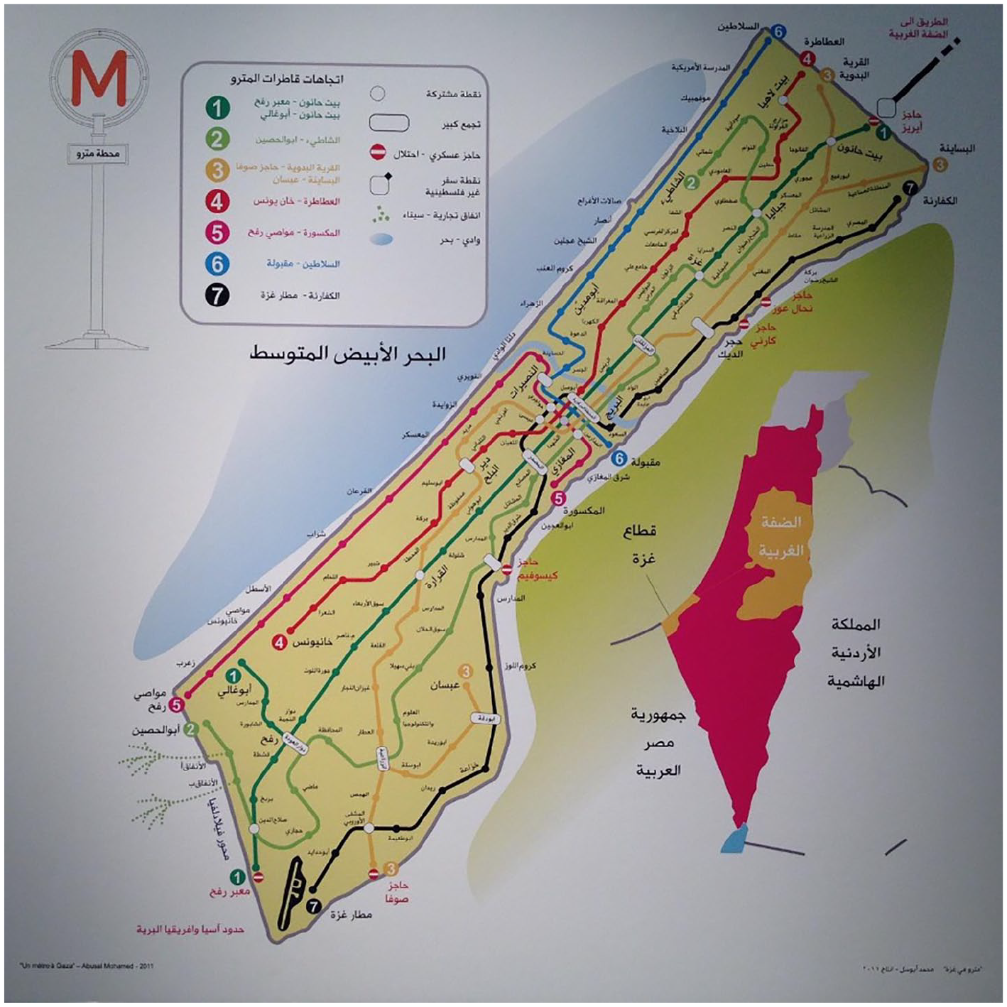
A depiction of the Metro system, by Mohamed Abusal, غزة في مترو (A Metro in Gaza) (2012).
But here is the rub: this is a future in which an airport and a metro can be re/built, for there is no fear of blockades, airstrikes, or wars that will re/devastate the rebuilding. Construction materials flow in and the tunnels that once smuggled people, medicine, and necessities are replaced by billowing subterranean channels transporting workers, school children, and beachgoers. It is a utopia, but one that cannot escape its dystopian present and past, even during the project’s construction.
[Abusal] hesitates after having been warned by some advisers that he may come under suspicion from the Israeli surveillance teams who may mistake his ‘Metro’ pole for a rocket which could be used to launch an attack on nearby settlements. He will discover that it is impossible to carry an iron pole and to roam around freely, despite its being an artistic project. He will also come to the realisation that if he ventures to do this, a dreadful bomb attack could befall the area, endangering the safety of the artist as well as that of the locations he dreams will become the metro sites. (Schembri, 2011)
At the point of creativity, the reality of the ongoing insecurity in Gaza shapes how the project unfolds. While Abusal frames the collection with reference to dreams (‘It’s a dream, an idea I’m putting out there’; ‘It’s a dream: it can cut the traffic and a lot of the pollution’ (Schembri, 2011)), the map and images have more in common with Bloch’s concrete utopia and Bauman’s (2010: 3) knife with the edge pressed against the future’. The possibility of having a metro is imaginable, on the horizon, but while the present merges with the past, the knife’s edge remains on the future. This is perhaps none more so than at the time of writing, as the Israeli bombardment has claimed more than 45,541 Palestinian lives, destroyed 45% of all housing units, decimated roads, and brought the healthcare system to collapse with power cuts, water shortages, and strikes on hospitals (UN OCHA, 2024a; UN OCHA 2024b; UNOPS, 2023). Today, from afar, we gaze on Gaza, the blue sea now meeting rubble, tents, fractured promenades. Abusal’s work once stood as a thoughtful visual commentary on what could be, our focus directed to the metro-signs. Now, our eyes linger on the background, images like Figure 2 a reminder of what has been. No longer just a future-oriented utopian vision, Abusal’s work has, in a time of genocide and urbicide, become a visual archive, an urban witness, and a multidirectional utopian vision that recalls Gaza as it was, as much as what it could be.
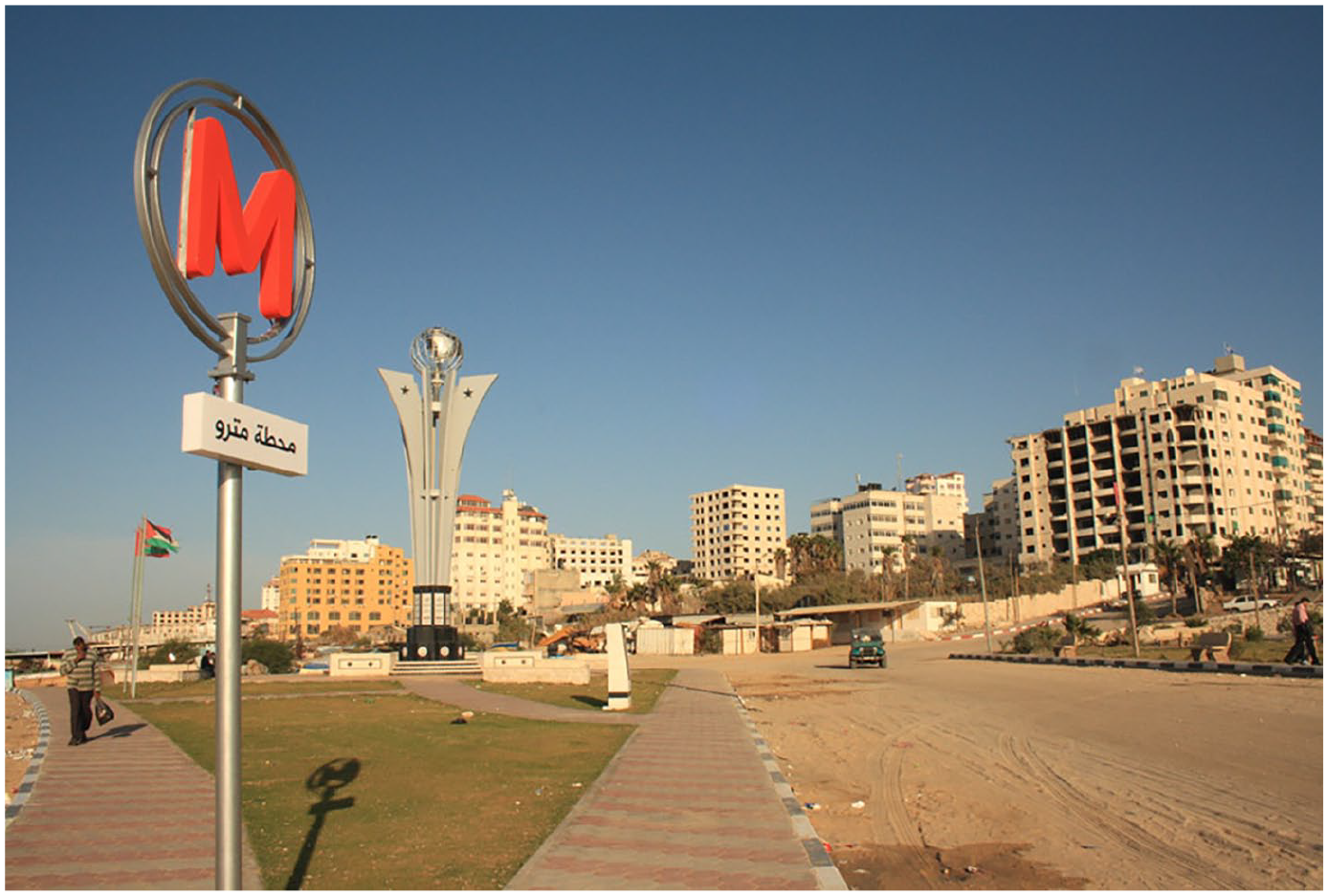
Mohamed Abusal, مترو في غزة (A metro in Gaza) (2012).
The metro signs in the photographs are one component of the project: to understand the political imagination behind the metro in Gaza, we must look at its map. The minimalist pamphlet reveals a paired back Gaza: the yellow Strip flanked by a blue sea on one side and a nebulous white land mass around the three remaining edges. The metro lines run straight, the stations offering regular stops on the journeys between checkpoints, border towns, and the coast. Before the ongoing genocide, the Gaza Strip was densely inhabited: 365 km² and home to 2.1 million people (UNRWA, 2023) – for scale, London is 1572 km² and home to 8.9 million people – and the map offers a vision of movement that circumvents the urban devastation. If Jaffe’s understanding of political imagination reveals how power should work, who should (and should not) participate, and who gets to feel a sense of belonging, then A Metro in Gaza presents a counter: a counter-map to the immobility and insecurity, that envisions stability that lasts long enough to not only rebuild the infrastructure but progress it further. ‘The political situation controls all our dreams. A big project like this would require a guarantee set in stone that it won’t be attacked in a war. [. . .] It can happen, but it depends on the political situation’ (Abusal, in conversation with Schembri, 2011). Abusal’s Metro map is a utopian project, tempered by the dystopia of today: the two cannot be disentangled. At the same time, the map’s familiar style is intentional: there is a ‘yearning for normalcy’ (Tamari, 2013: 49) that suggests an alternative normal is imaginable, albeit in a utopia in which the blockade and bombardment do not exist. The idea of movement that the map suggests is a radical political vision that brushes against the critiques of utopia as fantasy (Levitas, 1979), an impractical pipedream (Bauman, 2003), or unrealistic (Williams and Ball, 2014). Although the critiques of utopia resonate with Abusal’s ‘dreamlike’ work, his political commentary, expressed through the vision of normalcy, demonstrates the multidirectionality of utopia as the map renegotiates and contests the experience of war and controlled movement. In doing so, Abusal plants a seed in the viewer’s imagination that questions what is absent and why, as well as what is needed to move towards Tamari’s vision of ‘a natural life’.
Conclusion
For some time now, there have been murmurings of the death of utopia: are utopian ideals needed in twenty-first-century society? Or, has the dystopia of the climate crisis, conflict, and capitalism engulfed society to the point that imagining utopia is a challenge? The short answer is no: pronouncing the death of utopias has become not only a cliché (Eskelinen et al., 2020) but a tradition. Writing in 1979, Levitas was uncertain about the future of utopias, while the ‘littered debris of utopian projects’, accumulated by the end of the 20th century prompted John Gray (2007) to reflect extensively on the concept’s demise. Looking at global developments, including the rise of right-wing movements, the destruction of the environment, and the plight of refugees (whether arriving at Tunisian or British borders), we are living in bleak times (Lakkala, 2020; Salmenniemi and Ylöstalo, 2023). Similarly, in Gaza, the genocide has taken the human and infrastructural devastation to uncharted levels in the region. Against this backdrop, Abusal’s map becomes a request masquerading as a dream: safety, normalcy, a moment to build, to move freely. While a resolution might not be explicitly mentioned, the freedom of movement envisioned by Abusal signifies an outcome of a potential resolution. Meanwhile, in the West Bank, settler violence is increasing, and 2023 brought the highest death toll for Palestinian children killed by the Israeli forces and settler violence (126 by December 2023; Defense for Children International – Palestine (DCIP), 2024). A cheer for utopian ideals seems Pollyanna-esque, and yet, it is precisely in these conditions that utopia is necessary, as utopia, much like hope, is tempered with ambivalence, never quite severed from uncertainty or shifting circumstances.
The hope associated with utopian ideals is one part of the case for utopia. Another is the variety of ways that utopia can express desire, lack, and what is needed. The first step towards articulating or portraying utopia is to imagine: as Keijo Lakkala (2020) explains, ‘In a situation where it is difficult to imagine alternatives for destructive, anthropocidal capitalism, we need to teach ourselves to dream and to imagine again’ (p. 34). Far from announcing its death, utopia can be seized as a mechanism for imagination (of both the political and sociological kind), resistance, and – as the case studies in this article demonstrate – memory work. This article is concerned with a specific context, art maps by Palestinian artists that offer counter-maps to the alternatives that erase Palestinian place names, history, and life from the guidebooks and online/offline maps. Despite the passage of time and broader context, the conceptualisation of utopia by Bauman, Levitas, and Bloch remains vital, although the critiques of utopia as dreamlike stop short of imagining the potential for ‘pipedreams’ to highlight societal challenges. Instead, recognition of the symbolic significance of utopian visions allows contemporary understandings of utopia to be applied in the context of Palestinian counter-maps.
Both Abu-Eisheh and Abusal are attentive to utopian ideas of the past, present, and future, yet their works also urge the viewer to acknowledge that dystopia cannot be disentangled or discarded. Like earlier creative works with a utopian lean, the aspiration for an underground metro and the desire to be acknowledged suggests that there is a longing for both and implies what is needed to move towards ‘a natural life’ (Tamari, 2013). The reality is that the infrastructure of Gaza, so damaged through war, is unable to sustain Abusal’s dream; the need to speak the names of depopulated villages denotes an ongoing erasure that Abu-Eisheh’s Sorry resists. When combined, multidirectional utopias and Palestinian political imagination produce a cartographical memory work that provokes remembrance not only of names, places, and communities, but questions regarding their disappearance from the map. This is a moment of interrogation, as well as a challenge, both to the dominant political narrative and the mapmakers engaged in erasure. Palestinian political imagination drives vital memory work at a time when maps are increasingly engaged in cartographical violence, whether it is as a tool to visualise military violence in the Gaza Strip or envision spaces ‘empty’ of inhabitants.
Looking forward, there is a deeper question: What do the utopian counter-maps become? For some, they can provide an alternative view of the future from a past vantage point. At others, they emphasise the longevity of human suffering and/or the absence of freedoms and rights that society continues to fight for. In the context of memory, utopian visions paradoxically (given their inclination to look to the future) function as mnemonics: By highlighting what is missing today and what is needed tomorrow, they remind us of what was and what has been left in the past. In doing so, artistic representations of maps offer an insight into what is needed to move towards a ‘natural life’ that satisfies the ‘yearning for normalcy’ (Tamari, 2002, 2013). Through the subtle expression of political imagination and memory via multisensory approaches, such as Mona Hatoum’s Present Tense, or the emotional and affectual approaches of Abu-Eisheh and Abusal’s cartographical works, a multidirectional utopia is mapped visually and discursively, channelling the power of maps towards a narrative of remembrance.
Footnotes
Acknowledgements
The author would like to thank Mohamed Abusal for his support and consent to use his images. Thanks also go to the editors, Dr Inna Perheentupa, Dr Suvi Salmenniemi, and Dr Hanna Ylöstalo for their encouragement, and the Department of Sociology at Aberdeen for their critical insights.
Funding
The author(s) received no financial support for the research, authorship, and/or publication of this article.