
Abstract
The study grasps the transformation of agency in the context of mundane production and use of mapping apps. It is asked theoretically and empirically, who produces and maintains Google Maps as cartographic infrastructure and how is this kind of agency being reflected and acted upon from a lifeworld perspective. Firstly, findings are compiled from various interdisciplinary studies on digital cartography, platform capitalism and digital infrastructures. Since these studies focus on agency almost exclusively from a structural perspective, a qualitative study is conducted to explore the use of Google Maps in everyday life. 20 interviews with German users show that digitalization and datafication profoundly change the dynamics of how agency is perceived and reflected. It can be understood as a form of extension of agency because it is deeply rooted in the entanglement of Google Maps’ infrastructure and city dwellers everyday practices.
Keywords
Introduction
Whether used to organize holidays, as a route planner that navigates from the current to the desired destination, or as an interactive game where the user can catch little creatures along the way, smart mapping apps are more than just digital maps. Smart mapping apps like Google Maps, TripAdvisor or Pokémon Go represent location-based applications that have a multimedia database and are equipped with various sensors. They are installed on mobile devices and are based on GIS (Geographic Information System), GPS (Global Positioning System) or INS (Inertial Navigation System) (e.g. Malek and Hajibabai, 2004, n. d.). Especially since the establishment of mobile devices such as smartphones or smartwatches, consumers can access large amounts of information online while on the move (Sardianos et al., 2018: 690) and use interactive maps. With constantly evolving features and broad societal diffusion, mapping apps not only influence our everyday world as a digital twin distinct from it. They are firmly interwoven with everyday practices and the construction of space and place. Thus, perception, orientation and navigation in the world are closely linked to georeferenced data, and digital information (Kitchin and Dodge, 2011).
In our study we focus on the most widespread and widely used mapping app in the world: Google Maps. It combines places with additional georeferenced information from the commercial Internet and offers several navigation, recommendation and editing functions (Brantner, 2018: 18–19; Willis and Buschauer, 2014: 169–172): Whether it is the menu of a restaurant or the rating of its service, the opening hours of the family doctor or the detailed satellite view of the possible new neighbourhood. Around 15 years after the social diffusion of smartphones, Google Maps as the default mobile mapping app takes on an increasing control and steering function through the continuous collection of usage data and thus also exerts a considerable influence on the construction and perception of our surroundings.
Thus, a peculiar agency is inscribed in mapping apps. Using a mapping app goes far beyond individual and situationally observable actions. On the one hand, the displayed representation of space is based on processes of data filtering that consider specific locations, point in times, mobility patterns, and, in the case of Google Maps, individual consumer behaviour, preferences and interests. On the other hand, installing a mapping app on millions of smartphones is a requirement for its functionality, for example, in displaying traffic jam information or showing visitor flows of museums. In addition, individual comments, recommendations and ratings, and the supply of business information (e.g. opening hours, menus, contact information) have become an integral and indispensable part.
Our notion of agency is focused on the intertwining of cross-situational, technological and economically driven processes of data filtering, which are mostly opaque, and the everyday usage of location-based technologies. In doing so, we draw on a concept of agency derived from practice theory (Gentzel, 2015), which highlights two characteristics: 1) Flat ontology and relationality: The analysis of agency relates practices of human actors (e.g. interpretations, perceptions, routines) to the activities of technical artefacts (e.g. data processing, visualization). Agency in everyday life thus can be understood as an ‘entanglement’ of social and material, human and non-human elements (Hepp, 2022). 2) Materiality: Agency is material, because it is bound to human bodies, technical artefacts and natural objects. Thus, social knowledge and competencies play a particular role, which can be empirically grasped through the analysis of everyday routines.
Recent work in platform and infrastructure studies has highlighted that communication processes, access to and processing of knowledge, and the visibility of work are decisively shaped by the technological features of a platform and/or infrastructure (Gillespie, 2018; Van Dijk et al., 2018; Plantin et al., 2018). The design and function of Big-Tech, in turn, operate strictly according to the principle of profit maximization, as analyses from the field of political economy show (Srnicek, 2017; Zuboff, 2019). How and which data companies collect, select and process remains opaque und thus represents a certain form of power accumulation and inequality (Boyd and Crawford, 2012; Hepp, 2020). Furthermore, authors from the field of human geography argue that the ‘participatory strategy’ (McQuire, 2019: 152) of platform or surveillance capitalism leads to an editorializing (or scripting) of map content which evokes new fields of tensions and challenges concerning presentation and perception of space.
In terms of agency, this means, on the one hand, that more people and institutions than ever are passively (e.g. through app use and browsing) and actively (e.g. through recommendations, evaluations and additions) involved in the provision and maintenance of spatial knowledge. On the other hand, homogenization and closure characterize the transformation of heterogenous data to the visualization of spatial knowledge. According to findings from critical studies, we can assume that the editorialized spatial knowledge stocks and the technical design keep user agency in an expectable and manipulable range (Zuboff, 2019).
These findings derive agency mainly from the structural dimension (e.g. production logic, technical design): The increasing entanglement of technical development and everyday practices (Neff and Stark, 2003; Manovich, 2013), the ‘invisibility’ of digital platforms in everyday life (Chun, 2016) or the breakdown of social routines in case of a failure of digital infrastructures (Plantin, 2018) are intuitively convincing. But at the micro-level of individual everyday life questions arise, (1) which social and communicative practices have changed and how stable or performative they are (Shove et al., 2012), (2) which social rituals and constellations, time rhythms, as well as individual expectations and emotions (Boczkowski et al., 2022) are unfolding.
Theoretical framework: Google Maps in everyday life
Basically, the extent of audience or user agency corresponds to the possibilities of intervention in cultural, economic and social processes through which power is exercised and which can continuously change reality (Slack and Wise, 2006). In our introduction, we have outlined that agency in the context of digital maps cannot be described solely in traditional terms of consumption or reception practices. We need to contextualize agency in the light of overarching processes of change (Dahlgren and Alvares, 2013), especially considering the opaque side of power execution qua data processing (see in more detail Hepp, 2020; Hepp, 2022). Against this background it helps to revisit the fundamental sociological question of how individual agency can be understood in opposition to determinant social structures (Giddens, 1984; Hays, 1994), which are now in state of deep mediatization (Hepp, 2020). It helps to unfold the equality of both dimensions and their complex relationship from the perspective of media culture. The dimensions of the ‘circuit of culture’ depict the social conditions on both the structural and the individual level, in which culture as a way of life is included in this model (Johnson, 1986; Du Gay et al. 1997). This framework is excellently suited to structuring the study of Google Maps from the perspective of its cultural meaning (Mackay, 1997). It aims at to distinguish and simultaneously contextualize moments, articulations or forms of media culture. For our heuristic, illustrative purposes, media cultures can be understood as a circuit of production, products (as meaningful texts), their different readings and the embedding of these products and their meanings in everyday culture. Bounding those elements into a circuit emphasizes, on the one hand, that they need to be observed in relation to each other. On the other hand, it illustrates that each element represents a particular form, articulation or moment of culture.
This framework helps to collect and systematize findings from a widely dispersed and interdisciplinary state of research. Maps are not traditional objects of communication and media studies. Therefore, instructive analyses of digital maps originate from other disciplines like cartography and cultural geography. Another trajectory of informative considerations can be derived from structural analyses of surveillance capitalism and infrastructure studies.
We can now illustrate the different aspects of hybrid agency of Google Maps along the dimensions of production, use, representation (text) and everyday life.
Production
As centrepiece of surveillance capitalism (Gentzel et al., 2021) Google Maps features some typical characteristics of current platforms, for example, it is free of charge, accessible on many different devices, deeply interwoven with the commercial Internet, product of an Big-Tech company (Alphabet) and thus has reached almost a hegemonic status in a specific sociotechnical ecosystem (exact figures are not available, but estimates range from one to two billion requests per day (McQuire, 2019: 53; Ström, 2020: 6). Plantin (2018) characterizes Google Maps as ‘cartographic infrastructure’ and Mc Quire (2019: 155) notes that through the ‘participatory strategy’ it gained ‘structural dominance in the maps sector’. Due to its extensive global diffusion and integration into people’s everyday lives and routines Google/Alphabet receive a constant, georeferenced stream of behavioural data that individuals produce consciously (editing, rating) and unconsciously (using links, creating routes, comparing ways of transport) by installing and using the app. That data is used to categorize place and space and to update the basic services of Google Maps and the accuracy and reliability of ‘Ground Truth’, the base map of Google Maps which provides data sets to users via proprietary APIs. Zuboff (2019) emphasizes that this agency can be understood in terms of maintenance and classification work by the users, that is fed into a second exploitation loop through app use in data submission (user) or collection. In this, the behavioural data are not used to improve the product or the application but to create the most accurate profiles of users possible to predict and manipulate behaviour. In the context of Google Maps that means, for example, the display of restaurants or shops alongside daytime, location and interests, which is curated by utilizing the integrated lists, ratings and links. In that respect the app regulates what knowledge about concrete public spaces is provided, how individuals can perceive and explored these places, that is, whether a restaurant is visited, a monument is seen, a shop is found, and which streets will be used by the autonomously driving Google car in the future. So, for places and spaces, actors, companies, services and communities it is not just about being ‘on the map’ (Luque-Ayala and Neves, 2019), but also about staging and being staged accordingly, that is, making data available, managing ratings, keeping information up to date and staging it aesthetically. Revealing in this context is a study by Luque-Ayala and Neves who accompanied Google initiatives in Brazilian favelas. Based on observations and interviews they conclude that Google`s mapping projects are ‘never meant to be the calculability of communities as a whole, nor of their deficiencies, complexities and aspirations, but of their economic flows and businesses’. (Luque-Ayala and Neves, 2019: 460, 467).
On the one hand, this production logic of Google Maps illustrates that agency is related to it extends beyond individual and situational aspects of concrete observable practices. On the other hand, it points to overarching processes of change in terms of cartography or production of space (Lefebvre, 1991). That kind of map production causes one-sided distortions of spatial representations on the digital map, favouring a few but powerful actors. First, because the production logic of the Google Map is based on the availability of digital data and its surveillance capitalist filtration. This privileges highly datafied areas, countries, cities and neighbourhoods qua production logic. Second, because the option of altering maps (mashups) and the entanglement with the commercial Internet allows actors to map content and knowledge, to balance it through ratings, and thus to cultivate understandings of space that serve completely vague and opaque interests (Farman, 2010: 880; McQuire, 2019: 153).
Representation
The described features of production cause specific patterns of map content that influence knowledge of as well as perception and navigation in space, that in turn mould the production of spaces. In that sense, the map content, literally the widespread worldview, is basically editorialized by the operations of the cartographic platform Google Maps. Mc Quire characterizes Google Maps in this context as ‘one map to rule them all’ (2019). However, cartographers point also to evolving fragmentations of space that are based on filtering mechanisms geared towards probable individualized consumer behaviour (Shapiro, 2018). Some aspects of the Google map as representation or text are critical from a ‘traditional’ cartographic perspective: • Some national borders are not consensual and are mapped in a way that favours one party, as in the case of Taiwan and Tibet (Farman, 2010: 878). • The dominance of some widespread languages leads to signatures and labels that do not correspond to the locally embedded cultural practice of designation (e.g. other names, written symbols, iconic signs). • The above-described production logic privileges highly datafied spaces in which more people use mobile digital media more frequently. They are shown more detailed, are combined with more app functionalities – in short, they have a ‘better’ cartographic infrastructure – than spaces about which and in which somewhat less data is produced. • Obviously economic content is promoted. The signatures for retailers, restaurants or tourist attractions vary in colour, not in size – in city centres, for example, the signatures of fast-food stores are (depending on the zoom) just as large as those of the marketplace, city hall or cathedral. Moreover, the categories of location-based ‘discovery’ – as a feature to stimulate app and further Internet use – are overwhelmingly associated with forms of consumption (e.g. restaurants, clubs, shows, shopping) combined with the time of day and reviews of products and services that factoring in alongside location (McQuire, 2019: 156; Ström, 2020: 9).
Representation and text of Google Maps differ, however, not only in terms of the displayed content that accentuates specific places, shops and actors. Crucial is furthermore the continuously adaption of the map text to individual usage patterns of internet-based applications and programs. In this respect, Google Maps depicts all places on earth, but what it shows is potentially different for each user and ultimately serves to sell products and services. Due to the dependency on location, individual zoom, processed digital usage data, availability and topicality of local data, there is no uniform map text of global and local space anymore. For Zook and Graham, Google Maps represents therefore not just a mapping app, but a producer of a subjectively designed interactive space that influences the agency of the users in terms of the way people interact with their local environment (Zook and Graham, 2007: 480).
Communication and media studies pay attention to data filtering mechanisms if rights violations occur (e.g. the case of Facebook and Cambridge Analytica), or normative principles of democratic public spheres, and thus opinion-forming processes are called into question (e.g. Donald Trump and Twitter). Nevertheless, we should not overlook that public space is also an institution for negotiating social and individual self-understanding, cultural identity and political opinion. Due to the everyday mass use of Google Maps, it has become an essential part of communication culture and of existential importance for a multitude of actors and places, As part of a constantly calculating ‘digital skin’, it represents space ‘[…] visually in the form of maps and images; and informationally in the form of lists, recommendations, tags and categories of what exists […]’ (Rabari and Storper, 2015: 31).
In terms of agency representation and text constitute a symbolic dimension. As described, actions and decisions are bound to available information; practices and rituals are always contextualized socially, spatially, temporally and symbolically. How space is represented, which information is shown as relevant and which is excluded, which functions are offered and which are not, therefore, is crucial for perceiving spaces and acting in them. This symbolic dimension of agency is often bypassed, especially in adopting concepts from the field of Science and Technology Studies (Wajcman and Jones, 2012). However, it is hard to underestimate the meaning of sedimented symbolic worlds, the text of the globe, countries and cities, for questions of reproduction and change of everyday practices, in other words, the practical entanglement in the long run. How ‘deep’ and widespread Google Maps is embedded in our everyday life can only be observed if medial contents, functions and symbolic forms, for example, as expectations, norms or emotions, are taken into account.
Practices and everyday culture
Some researchers have already dealt with the question of mapping apps and agency, mostly by applying a media centric perspective and without connecting their empirical findings to the structural dimension. For example, Hofmann and Mosemghvdlishvili (2014: 265) investigated in their study, how apps with augmented reality elements for navigation affect users’ perception of their surroundings and found that app users are less aware of their surroundings than non-users. Roesler-Keilholz (2014) postulates that maps are not only pure representations of the environment, but also shape the recipient’s view of the world. She highlights that Google Maps offers the freedom for immersion and interaction with virtual maps and that the community aspect is an essential part of the use of such maps (Roesler-Keilholz, 2014: 169, 180). The work of Abend and Harvey points in a similar direction, declaring a digital transformation of map use and observe a development of maps to ‘geomedial action spaces’ (2017).
Supporting our argument, Reichert (2008) claims that the user practices of mapping apps unfold within specific social and cultural contexts and thus should not be defined from the merely uniform perspective of the producers. He considers a gradual dissolution of the binary hierarchy of production and reception as crucial for further investigations of the agency with digital maps. (Reichert, 2008: 155). Mapping apps are not only used for spatial orientation, they also activate a constant reproduction of space through practices of mapping use, interpretation participation etc. (Roesler-Keilholz, 2014: 177).
Agency, reproduction and modification
The particular focus of our study is the hybrid agency that unfolds by using Google Maps. With the help of the circuits of culture, we were able to show how closely connected the use and production of Google Maps are and shed light to what extent the representation of spaces and places is related to the lived everyday culture. Concerning agency, this raises questions that have not been reasonably considered in previous concepts. Exemplary for this are analyses across concrete situations and individual sequences of agency, the consideration of the symbolic dimension that comes with media technologies and artefacts into play. The latter, for example, the appropriation or cultivation of specific symbolic world texts and practices how to interact with them, is linked to questions of reproduction and change in everyday practices.
Thus, we shed light on the appropriation side of Google Maps, analyzing the mediatization of spatial knowledge by exploring the micro-level of individual usage practices, everyday contexts and sedimented expectations. From the viewpoint of agency, the decisive factor is the ‘room for manoeuvre’, which can be smaller (if users’ practices are essentially determined by Google Maps’ structures or affordances) or larger (if Google Maps can be actively and initiatively shaped by its user practices). Also, platform and infrastructure studies point to the entanglement of data-based technological systems and the everyday life of individuals.
This research interest obviously requires a non-media-centric empirical analysis (Morley, 2009). Starting points are everyday practices, rituals, expectations, norms and emotions associated with a situational agency or relying on the constant availability of Google Maps. We investigate empirically following specific research questions from the perspective of grounded theory (Krotz, 2019): (1) What are people doing when using Google Maps? Which practices and rituals have evolved? (2) Which expectations, norms and functions become obligatory after 15 years of mobile Mapping Apps? (3) In how far do people use other mapping apps than Google Maps, and if so, what conditions must be met to use alternatives to Google Maps? (4) What kind of agency do people reflect from a lifeworld perspective?
Methodology
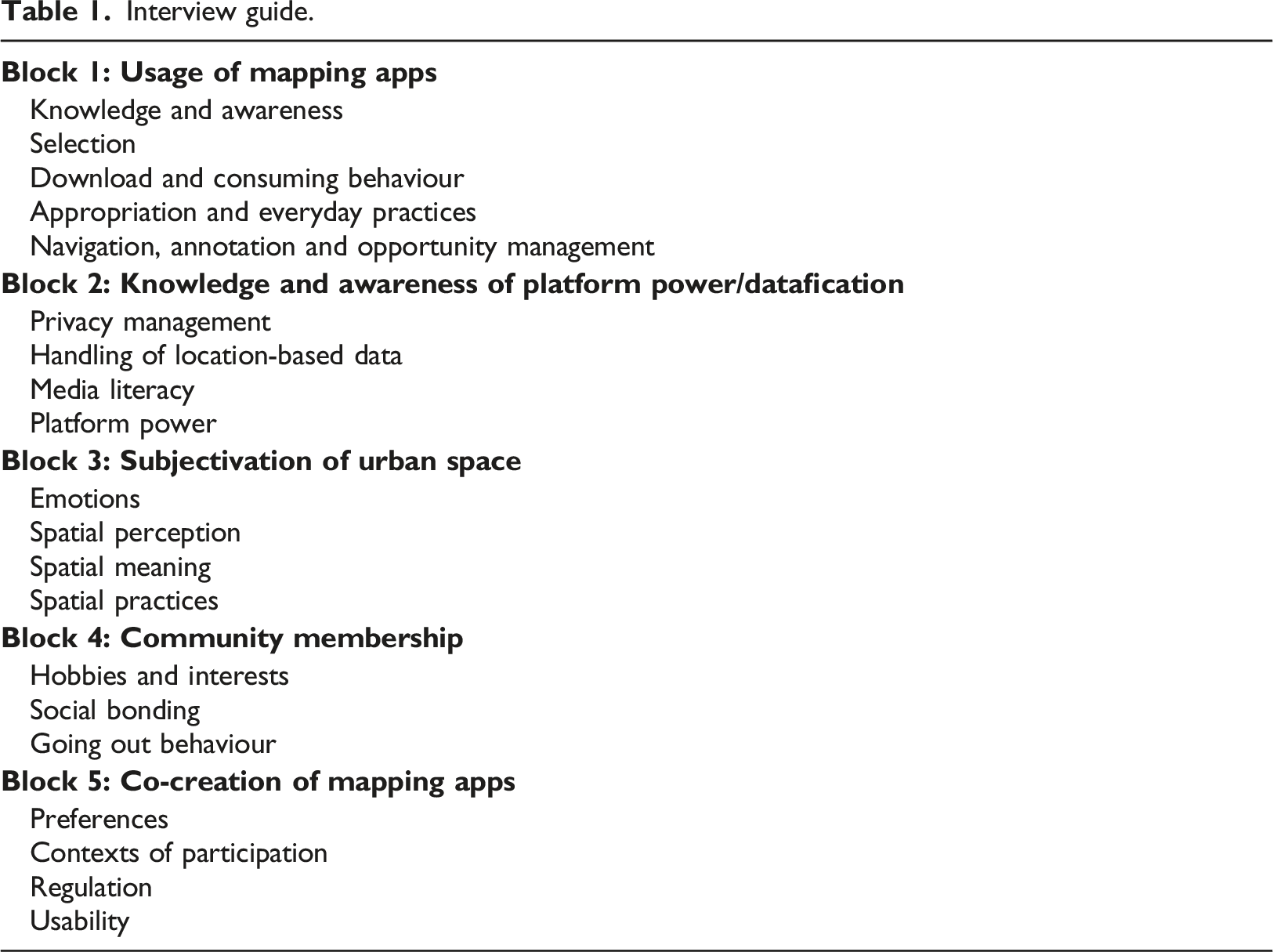
Interview guide.
For the case study, an attempt was made to compile a sample that was as diverse and comprehensive of social circles as possible in the sense of theoretical sampling. In addition to a balanced gender and age distribution, subdivisions were made regarding occupation, leisure activities, media/technology affinity and use of mapping apps. Participants were recruited as a convenience sample in the context of a research seminar, where M.A. students were asked to recruit interviewees from their social networks (Misoch, 2019: 207). In the end, the sample consisted of 20 media users, with the youngest participant being 17 and the oldest 56 years old. It turned out that all of these persons could be characterized as casual Internet user, which fit to research interest of investigating routinized practices in mundane life. All of them were recruited from a medium-sized city in Germany, which was the location of the research network.
On the first sight this selection stands in contrast to media-ethnographically oriented research on media innovations, which focuses from the outset on particularly active forms of media appropriation. Building on this most findings are to be limited in their explanatory power and scope, as they are very specific random samples regarding the media technology, its culture and user. But in the case of Google Maps, it can be assumed that so-called casual users, who are probably not characterized by such a high level of commitment and loyalty, but stand out having many years of experience and a special connection to this app. The pragmatic research justification behind this methodological limitation is the explorative interest in knowledge of the study as a pilot study and the basic assumption that findings regarding agency will be most clearly shown in the case of the casual users of Google Maps. Of course, outstanding further studies will have to check the explorative findings with a representative survey in a next step.
In the interests of ensuring a context-sensitive recording of the integration of mapping apps into everyday worlds and the agency associated with, the interviews were coded using the logic of grounded theory (Linke and Schlote, 2018). From this perspective, starting from individual conversations, the aim is to abstract a larger picture that allows for a theoretical generalizability (Krotz, 2019) of city dweller’s media repertoires (Hasebrink and Domeyer, 2012). Axial coding made it possible to reconstruct the consolidation of the media set based on nine categories (individual background, engagement practices, community membership, outgoing behaviour, city perception, google maps preferences, motives of app usage, app repertoire, media literacy) as well as to establish theses regarding the dimensions and context specifics investigated (see next chapter).
Findings
Practices and rituals of using Google Maps
As expected, Google Maps is the default navigation app of all users. Nevertheless, highly specific practices occur using it such as checking ratings as well as route planning, which are most mentioned by all users regardless of lifestyle and socio-demographics. Google Maps manages to integrate the medium map into a whole media world, even to dominate it, because it works in combination with other interactive applications (e.g. rating, localization). Of course, subjective purposes of use differ heavily among the interviewees, as does the affinity for this app. While casual users mainly exert the navigation function, heavy users, for example, seem to deal with several functions such as the ratings of restaurants, bars and shops. Route planning, that is, the way from A to B, represents the most frequently used feature. Road traffic reports and the possibility of ‘exploring’ the surroundings are also at the top of the list. The change between map and satellite view as well as the option to choose intermediate stops are also mentioned more frequently. The following interview excerpt stands exemplary for the preferences of our interviewees regarding the functions of Google Maps and its central position in everyday media life. ‘What I find very good is [...] that I can see on Google Maps how I can get there by public transport, as well as the distance on foot or the approximate taxi costs, or I can also see how far it is by car etc. [...] I really have a comparison of how I can get there best and fastest. And what I also like is that I also perceive the surroundings, i.e. I can orientate myself a bit and say, okay, there’s the restaurant or the petrol station is shown to me as an orientation point and then when I'm on foot or with public transport, for example, there are often several exits, especially with the underground, and if you’ve accidentally chosen the wrong exit, then it’s simply helpful if you can orientate yourself, where am I at the moment, in which direction do I have to walk now?’ (Alice)
In general, the interviewees show a very strong trust in Google Maps. ‘I actually rely on the app, especially when I need to get there quickly, because I think it will pick out the fastest route’. (Anke) The routes suggested by Google Maps are predominantly perceived as very appropriate and are normally used, as from the users’ point of view they provide a safe and reliable way of planning that also takes little time. It is very much appreciated that not only simple routes are given, but also a lot of information to make planning easier in advance or during travel. For example, changes such as road closures or traffic jams can be displayed, but also alternative means of transport and costs for these are included.
The interviewees particularly highlight that time calculation for routes are given in advance: ‘It’s quick. Which is of course a time saver. It’s practical and easy. You just indicate where you want to go, then the destination addresses, and it immediately suggests how to drive or walk and just suggests different routes. It’s just convenient’. (Maria)
Additionally information about places (e.g. opening hours, review, pictures) is mainly valued: ‘You simply have another personal experience, and you can also find out how other people think about a place and rate it. For example, an opinion about a bar. Then I can draw on other experiences and learn more than just the name of the bar. And it’s not a fake, it’s from normal users, real guests, real visitors. You can rely on that a little bit’. (Lena)
These practices provide a sense of security and control for users that is not questioned further. Through this process Google maps generates and maintains its status of (un)conscious infrastructure, which is central in users’ everyday lives. Because its operating principles are opaque, users are not aware of doing infrastructural work for a worldwide platform. In general, we have only found three critical comments in all interviews, such as this exemplary one: ‘Yes. I find it a bit problematic in general, that they [the destinations] are already dependent on how much the respective company pays Google, that they appear first now, for example, or appear from a zoom level that is further out, and so on. So maybe that would be the only thing that goes more in the direction of marketing. Instead of me really benefiting from it. But on another level, it’s not necessarily for me as a user, but it’s a bit problematic that you, as the owner of a business, are so dependent on being placed on Google Maps, because so many people use it to find the nearest hairdresser’s or fishmonger’s or whatever. So maybe that’s a point of criticism, that Google doesn’t have enough competition or that it’s the most important map tool, with the economic effects’. (Markus)
Obligatory expectations, norms and functions
Goal-oriented navigation is on the rise, strolling through a city is becoming less, even though a desire for (exclusive) ‘surprises’ and ‘insider tips’ is expressed by most respondents. Google Maps manages to economize and rationalize the spatial and urban experience without the business model behind is really being perceived, understood and valued by its users – at least not in terms of infrastructural, maintenance work. By doing so it turns out, that Google Maps clearly monopolized the domains of urban placemaking and mobility from the perspective of practices and doings as well as of (cartographic) knowledge or ‘discourse’. Additionally, the process of subjectivation of positive and negative experiences with Google Maps seems to be very ambivalent among the interviewees, and often focused only on usability issues. A frequently mentioned point of criticism is the unclear directional information that is often displayed when starting a route on foot. The app is not able to recognize the perspective or the angle of view of the user in his or her position. Accordingly, the user cannot intuitively decide, for example, in which compass direction he or she should stark walking or whether he or she should follow the road to the left or to the right. Therefore, the user has no choice but to walk a few steps until the app recognizes the direction and suggests a correction of the path, if necessary, which is often experienced as a difficulty: ‘Sometimes it’s not so much because of the app itself, but also because of the location of my mobile phone, my mobile phone sometimes doesn’t know which direction I’m facing, then it’s difficult. My mobile phone says I'm facing the other way and, well, I don’t know, if I’m standing there and there are four streets leading off and my mobile says I must go that way, then I think to myself that's not right. Then I must look at all the streets first to get an orientation in which direction I have to go now’. (Heike)
One of the frequently mentioned merits of Google Maps is the navigation function. However, it may cause uncertainty and confusion, as the information is not always correct. The reason for this could be, among other things, self-generated content of users, which is not necessarily truthful and is not always sufficiently scrutinized by Google itself. The control of content could therefore play an important role here. Another reason could be obsolete information about locations which should be updated. It can therefore happen that a roundabout suddenly appears in the route instead of a traffic light. The following interview excerpts draw attention to the occasional but crucial situations in which users are confronted with this problem. ‘It’s a funny story if I can elaborate a bit. We were in Thailand in 2018 on one of the islands and then took a rental scooter, it’s a very sparsely populated island, and then we were on a mountain and saw on maps that there was a green symbol and it said something about a temple. Then we thought, cool, that must be the highest point, let’s go there. Then we walked for an hour through the jungle, it was wild, and in the end [...] we arrived there and in the middle of the jungle there was a, that, in Germany that would be a bird house. These are little house temples that people have in front of their houses. And after an hour it was standing in the middle of the forest, nothing else. I was rather disappointed’. (Roland)
Traffic reports, which are perceived as an important feature, are based on data collections of other Google Maps users, which is not validated from the perspective of data handling. These reports sometimes turn out to be incorrect, as the following interview excerpt exemplarily shows – nevertheless this is not detrimental to the centrality of Google Maps: ‘To be honest I think Google Maps sometimes lags a bit behind. Because I just had that yesterday. It showed me red at the main road, but in the end, there was nothing. There was traffic, but it was the wrong color, so to speak. And that's why I don’t really trust it, to be honest. I can see when it’s orange or red that there's a lot of traffic, and that's usually true, but the thing with the traffic jam [...] But I’ve also experienced that once in Sweden, when they showed us a traffic jam and told us to drive around it, because otherwise we’d need 20 minutes longer, and in the end, there was nothing. And that’s just [...] I don’t always know whether I should trust that there’s a lot of traffic. It’s great that road works are indicated because they don't usually disappear from one moment to the next. It’s always up to date, but I honestly trust radio reports more when it comes to traffic jams’. (Lorena)
Besides this process of everyday cultivation of a highly rationalized and efficient route management, users nevertheless virtually desire an individual and exclusive treatment. They have the aspiration to gain an added value, or the possibility to discover new places that they would not have found without the app. ‘Especially on a nice summer evening, walking through the city to see a little bit of something. So NOT [!] according to the motto “the journey is the reward,” clearly’. (Roland) The interviewees particularly emphasized the explore tab, which is not only seen as a positive way to get to know foreign places better, but also to find new things in their own city: ‘I often notice when I’m out with friends and want to have a coffee. Then we often say, “hm, where are we going” and there are a thousand cafés in Regensburg [German City]. But still, I’m always overwhelmed by where to go, and I always go to the same ones. That’s why I think it wouldn’t be so bad to get a bit of inspiration or something, just to be motivated. Just try something new, especially if they upload pictures or audios or something. If you can listen in, oh what kind of music is playing or what are the people like? I think that would be cool. So, I can already imagine that, yes’. (Nadine)
Interestingly, when confronted with our self-developed mapping app the interviewees stressed the aspect of expectations in a much more nuanced way. They voiced that they don’t expect just a map which shows places or routes from one place to another; they want to be actively involved and to be able to contribute to the design of the map itself. Through the interactivity of a mapping app and the ‘collective knowledge’ they expect to receive not just the ‘obvious’, but also ‘insider tips’ and additional information (Roland). ‘There will always be people who know their way around a city better and know other corners. They know insider tips or places that have just opened. Or even if they are more hidden. That I wouldn’t find as a non-local. And that’s practical when others can draw your attention to them’. (Lena)
The relevance of other mapping apps
Additional mapping apps are often only discovered and integrated in the media repertoire, for example, if they better fit to specific pastime practices and their characteristics. An interesting example seems to be motorbiking. Bikers may also reach their destination with Google Maps, but for this group the route is decisive not the destination. Here, winding routes and great panoramic views are particularly in demand. ‘My boyfriend and I ride motorbikes and my boyfriend is a hopeless case when it comes to orientation and he has had the app for a while. I used to just drive around, but now when I’m trying to get somewhere, because Google has a problem, it only shows me the quickest way, often federal roads, and with a motorbike it’s a bit pointless. Calimoto shows you the way, but a curvy route and it avoids everything that's bigger than a main road, so you just have a nice route. It takes a lot longer, but it's a lot more fun’. (Heike)
Another individual means of transport that is not considered by Google Maps is hiking. Maria elaborates on the feature of a specific navigation app for hikers called Bergfex. ‘When I go hiking, the app is a wonderful helper. For example, they make a sound if I leave the path, i.e., if I take a wrong turn, then an alarm sounds and I can quickly look at my mobile phone and see: Hm, I should have turned differently, so that they are a help to me in these specific situations after all and I can just rely on them’. (Maria)
Additionally, the influence of other mapping apps is more likely to be present when the surroundings are not well-known but are essential to everyday activities, for example, being on holidays. Roland, for example, uses the internationally well-known travel app called TripAdvisor, where users can book seats, tours or tickets directly via the app.
The role of participation and agency
Although the interviewees are consistently positive about the fact that Google Maps automatically takes over most of the tasks, it is still a subjective requirement for them to be able to actively participate or at least to have the feeling of being able to do so – but only if asked for. For example, respondents state that they would like to be able to choose their own favourites from the routes presented and additionally adapt them to their own needs, such as the choice of means of transport: The app is rated negatively, if it is not perceived as sufficiently adapted to the user’s individual situation. For example, the location cannot be localised correctly (Anke) or no further settings can be made, such as an adjustment to the vehicle: ‘[…] [S]pecifically for our motorhome […] we would wish if there were the possibility […] that it would then ultimately find the suitable route or road for me based on this. Just like you find it in classic navigation devices in motorhomes that are specially designed for that’. (Mareike)
In terms of agency, options like creating individual routes and saving favourite places are very much appreciated. This gives users the opportunity to have a say in which places could be found on the app and to actively participate in its design: ‘So even on Google I’ve written a lot of reviews, I also like to add pictures and do it in detail. And if I like the app and I’m on the road there myself, of course I’d like to do detailed reviews to maybe bring others closer. Clearly, or also to share my own experiences’. (Roland)
It should be noted here that the respondents consider uploading own content as desirable in principle, but mostly too complicated or time-consuming. But in general, ‘room’ for agency is considered important by the users only on request. Our results show that specific possibilities to actively participate (see in more detail Carpentier, 2011) in and through mapping apps are not known and not really accomplished in the everyday life usage of Google Maps. Although most respondents can be classified as ‘passive’ users that hardly edit the map, the possibility to create own content seems to be of relevance if asked for. This is most likely since almost all interviewees state that they rely on reviews and rating from other users for everyday decision-making situations such as choosing a restaurant or leisure activities. Even though Google Maps already offers some ways to engage and interact with others, it lacks a certain personal touch from the viewpoint of its users. Besides the possibility to give ratings and thus publicly express one’s opinion, a more individual and self-determined form of participation and therefore of agency is missing.
Conclusion and discussion
Agency is changing fundamentally in times of digitality and datafication. The transformation process is multidimensional and contradictory – this is precisely what characterizes the potential of agency in technological environments in general. Building on this we can assume that the central role played by complex, dynamic technology of Google Maps in the data-based constitution of the everyday world navigation and mobility manifests new forms of agency. Although all respondents show an ambivalent, sometime negative perception of Google Maps, for example, because of incorrect information or uncertain position, they show a very strong and unquestioned trust in this application and its usefulness. This can be analytically traced back foremost to a dominant market position, enormous usability and highly routinized practices. It must be emphasized, that casual users find it difficult to reflect on the participatory and agential potential of Google Maps. But it’s amazing, that all respondents are pleased only with the impression of agency and the potential for engagement in urban placemaking and mobility. The real enactment of agency is extended (un)intentionally and happily to the mechanisms and automatisms of Google Maps. So, we can conclude, that the app is taking over important aspects agency indefinitely for now for the connected domains of the lifeworld if the nexus of technology, user and lifeworld is stable, uncomplicated and conflict free. This ‘take over’ should be not understood just as of form of delegation based on human satisfaction and technological usability. It is a form of extension because it is deeply rooted in the entanglement of Google Maps’ infrastructure and city dwellers everyday practices (see in more detail Hepp, 2022:476-478).
By investigating the individual ‘room for manoeuvre’ and its data-related infrastructure and requirements we can comprehend, how Google Maps is able to shape spatial practices and knowledge and how this is perceived by its user. People in urban spaces navigate using Google Maps routinely to traverse space as efficiently, disruption-free and quickly as possible. Moreover, Google Maps’ features of the ‘networked image’ (Gentzel, et al., 2021) have infiltrated expectations and routines of moving around. Because it is taken so granted for the maintenance of everyday life, it is inseparable incorporated into daily routines and vice versa. By doing so, Google Maps is no longer used only as a ‘map’. On the one hand it acts as an intermediary for further information (e.g. opening hours, available goods, prices), reviews of products and services, on the other hand it heavily constructs the perception of space and place.
Our study exemplifies that structuring communication processes and knowledge access through platforms and infrastructures are associated with a feeling of informed-ness and security in the individual appropriation of spatial knowledge. Technical features and options that demand the delegation of agency from the users have become the norm for preparing and presenting cartographic knowledge. While the possibility of individual agency is described as significant and positive in the interviews, its limitations were not recognized and discussed further – addressed only in the context of specific pastime practices. The ambivalence of Google Maps, for example, false traffic information, shows no negative effect on the trustworthiness of the application. In the end the delegation of agency leads to the circumstance, that the wish for active editing of the map among other forms of agency is not developed by the interviewees – nevertheless these forms are highly appreciated when the respondents are confronted with an open-source mapping app. The individual enactment of agency through Google Maps in the mundane lifeworld seems limited to the rather passive evaluation of products and services at specific locations and the retrieval of further information (e.g. opening hours, menu cards) from the commercial Internet.
The feeling of security and control based on comprehensive information is even more impressive for the editorialization of knowledge and thus the pre-structuring of decision horizons. The ability to access current georeferenced data streams (e.g. traffic jams, events) at any time and from any location evokes a sense of sovereignty and expertise. Several critical voices point to biases, selection and standardization processes for the platformization of spatial knowledge (Luque-Ayala and Neves Maia, 2019; McQuire, 2019; Plantin, 2018). This research, which tends to be structure-oriented, combined with a broad exploration of user’s practices, evaluations, and patterns of reflection, could address the distribution and structuring of agency in a much more nuanced way – for the use of cartographic platforms and beyond.
Footnotes
Declaration of conflicting interests
The author(s) declared no potential conflicts of interest with respect to the research, authorship, and/or publication of this article.
Funding
The author(s) disclosed receipt of the following financial support for the research, authorship, and/or publication of this article: This work was supported by the German Federal Ministry of Education and Research, 01UO1820A.