
Abstract
This article examines the military violence of land use and infrastructure. The analysis discusses the case of the British Army’s Royal Corps of Engineers in 1860s British Columbia and in Helmand, Afghanistan following the post-2001 invasion. It charts how across British colonial and liberal military projects, military infrastructure activities have mobilised towards the goal of capitalist development. Drawing analytic lines between the Royal Engineers’ activities establishing the settler colony and colonial capitalism in British Columbia and their role in imposing liberal social, political and economic norms in Helmand, the article puts forward an account of why, how and with what effect military violence can include things such as the felling of trees, the issuing of private land title, the use of topsoil for road fill or prohibiting local farmers from growing tall crops near a roadway. The central argument of this article is that we should conceptualise and understand military activities such as these as violence. This analysis develops understandings of violence within scholarship addressing coloniality, liberal war, settler colonialism; and land, territory and infrastructure. Beyond the immediate analysis of specifically military violence, this discussion has broader implications for understanding the nexus of infrastructure, land and violence.
Introduction
This article begins its journey with two roads. The Cariboo Road was built in British Columbia, Canada in the early 1860s, and Route Trident was built in Helmand, Afghanistan in 2009. These roads, separated by a continent and 150 years, were both built by the British Army’s Royal Corps of Engineers and are linked by common threads through which projects of colonial and liberal capitalist progress, civilisation and development are achieved through the military degradation and appropriation of land and the forcible reordering of human relationships to and with it. Through the example of military engineering, in this article, I understand this material and epistemic reordering of land and environment as military violence, a perspective that stands in contrast to the typically held view of military violence as a matter of individual bodily injury (Scarry, 1985). Doing so involves drawing analytic lines between the Royal Engineers’ activities establishing the settler colony and colonial capitalism in British Columbia and their role in imposing liberal social, political and economic norms in Helmand. The central argument of this article is that we should conceptualise and understand military activities such as these as violence. The article puts forward an account of why, how and with what effect military violence can include things such as the felling of trees, the issuing of private land title, the use of topsoil for road fill or prohibiting local farmers from growing tall crops near a roadway. This analysis furthers understandings of violence that have been developed across scholarship concerned with coloniality, liberal war, settler colonialism; and land, territory and infrastructure.
In 1859, James Douglas – governor of Vancouver Island – wrote to Edward Lytton, British secretary of state for the colonies: ‘[t]he great impediment to the development of the interior resources of the Country now arises from the want of roads. British Columbia can never be great or prosperous without them’. A road building project to address this shortcoming would, he wrote, ‘open a safe, easy, and comparatively inexpensive route into the interior of British Columbia and give facilities at present unknown to the miner and merchant, for the development of its mineral resources’ (Douglas, 1859b). In 1858, the British had sent 150 Royal Engineers to British Columbia as a response to deteriorating order during the Fraser Canyon gold rush (Woodward, 1974: 14–15). The Royal Engineers undertook a range of infrastructural tasks in British Columbia. They surveyed land so that it could be sold, set out townsites including schools, churches and Indigenous reserves, assessed mineral resources, fisheries and the potential of land for agricultural use. But a core concern of the Royal Engineers in British Columbia was building roads including the one Douglas proposed, which came to be known as the Cariboo Road. The road traversed a route of approximately 550 km and is often cited as testament to the Royal Engineers infrastructural prowess (see Figure 1; (The Colonial Despatches of Vancouver Island and British Columbia 1846–1871, n.d.)
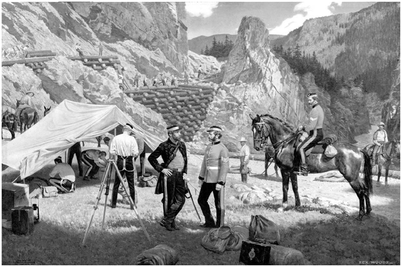
A 1967 painting celebrating the Royal Engineers construction of the Cariboo Road (Source: Courtesy of the BC Archives).
In 2009, in Helmand, Afghanistan, the British Army’s Royal Engineers began building the road that was known as ‘Route Trident’ by the British and the ‘New’ or ‘Big’ road by Afghans (Ministry of Defence, 2010b; see Figure 3).The road connected Helmand’s provincial capital, Lashkar Gah, with the neighbouring town of Gereshk–an ‘economic hub’ (Ministry of Defence, 2010c). It was designed, first, to make British military supply runs to regional patrol bases quicker and ‘more secure’, reducing a travel time of 36 hours to 30 minutes, and second to underpin the economic opening up of the region as part of the British military’s counterinsurgency strategy (National Archives/Ministry of Defence, 2010b). The Commanding Officer of 28 Engineer Regiment described the road building project as ‘a fantastic combined effort of military, contractor and local nationals on a “cash-for-work” scheme’ which would ‘provide a strong and durable route through the area which is already encouraging local markets and social movement around the area’; it was ‘Good engineering, delivering local employment, secure routes, and commercial and social opportunities’ (National Archives/Ministry of Defence, 2010a).
Engineering as a military specialisation is often presented as benign. British military engineers are lauded as historic and present-day builders of life-supporting and life-improving infrastructure. In British Columbia, the Royal Engineers have been the subject of extensive civic reverence as industrious founders of the province. In 2015, for instance, Quesnel Museum celebrated the 150th anniversary of the completion of the Cariboo Road with a Royal Engineers living history re-enactment event to ensure ‘that a vital period of B.C. history is kept alive’ (Quesnal Observer, 2015). The Royal Engineers’ ‘reconstruction’ work in Afghanistan and Iraq was the subject of myriad positive Ministry of Defence press releases and British media features throughout the post-2001 invasions and occupations. These stories typically featured a Royal Engineers regiment engaged in restoring sanitation or electricity, improving local mobility through road or bridge building, or restoring a damaged or dilapidated school (National Archives/Ministry of Defence, 2010a; Tenby Today, 2005). Viewed these ways, military engineering work can seem not only aside from the military business of violence but ameliorative of it. These celebrations of apparently benevolent engineering and infrastructure projects contribute to the legitimisation and exoneration of the broader military and political projects of colonialism, settler colonialism and liberal war, imagining them as also to varying extents benign (Cowen, 2020: 471; Griffith, 2017). This includes popular discourse summed up in the appeal ‘but what about the railways?’, a reference to the supposed positive infrastructural legacy the British left behind in India (Tharoor, 2017). This article is an intervention in this broader political stakes and landscape.
Following, literally and figuratively, the routes opened-up by the Cariboo and Trident roads, the article first introduces empirical examples of the kinds of degradation and appropriation of land that the analysis is concerned with, and then draws on and places several bodies of literature into conversation to derive a framework for understanding these practices and processes as violence that materially and epistemically reorders land and environment and human relationships with it. Applying this framework, I describe how the institution of the Corps of Royal Engineers was organised for the project of British Empire, the establishment of the colonial world system including infrastructure for colonial capital accumulation and the scientific establishment of categories of race. In the article’s central sections, I set out how the violence of the Royal Engineers’ work in British Columbia was predicated on material and epistemic reordering of land and environment in the service of settler colonialism and colonial capitalism, and then how land degradation, appropriation and the reordering of human relationships to land were central to the Royal Engineers’ role in the imposition of economic and governance norms in Afghanistan during the post-2001 occupation and counterinsurgency. The analysis illuminates how violence centring on land has been a feature across different times, locations and over-arching arrangements of the colonial system.
Conceptualising land, infrastructure and violence
During the post-9/11 occupation, the British set up the British Area Claims Office for Afghanistan. Its purpose was to receive and rule on claims from civilians for death, injury or damage to property resulting from British military activities. Taking 2008/2009 as an example, the Office received 2120 claims, financially settling 736 of them with payments totalling £452,707. The records that the Office kept are contained in nine years’ worth of spreadsheets covering 2006–2015. Understandably, claims relating to death and physical injury initially stand out, and Thomas Gregory (2020) has drawn on equivalent US data to write compellingly about the politics of ‘condolence payments’ for civilian death. Analysis like this is vital, but the data are also a documentation of other violences.
A very high proportion of the claims relate to damage to land or farming infrastructure including damage to crops, killing of livestock, appropriation of land for military purposes, destruction of farm walls or wells, prohibitions on farming within a particular radius of a British military position, or on growing tall crops near military positions or roads. In the winter of 2011, for instance, the British Army widened a road to improve access to one of their command posts. The man whose land the road cut through told the Claims Office that in the course of their activities the British ‘cut down 10 fruit trees, took 4 jerabs of his wheat field to extend road and provide aggregate, and demolished 200 m of walls’. 1 In the spring of 2012, another claim records that ‘100 large fruit trees and 200 small fruit trees [were] cut down by ISAF’. In the spring of 2011, the British Army cut down ‘two jerabs of mulberry and pomegranate [sic]’ ‘to allow line of sight’. In the summer of 2010, the Office processed a claim from a farmer who had been prohibited from growing ‘30 Jerabs of corn’ because – in the interests of security – ‘high crops cannot be grown within 300 m of Route Trident’.
We should, I argue, conceptualise and understand military activities such as these as violence. To do so, in this part of the article I bring existing work into conversation. The foundation for the article’s framework is the theorisation of coloniality and periodisation of the colonial world system. From this undergirding account of global power and violence, I bridge to areas of scholarship that engage with violent mechanisms that are of or relate to land and infrastructure. This encompasses conceptualisations of settler colonial violence, land, territory and ‘slow violence’, and the connections between infrastructure, capital and violence.
The colonial world system
Conceptualisations of the colonial world system and coloniality illuminate the connections between the colonial, capital and liberal warfare and the global contours and distribution of violence. As developed by Anibal Quijano (2000, 2007), Walter Mignolo (2007) and others (inter alia Dussel, 1995; Grosfoguel, 2002; Lugones, 2007), accounts of the colonial world system describe how the world in modernity was structured along lines of racial differentiation and hierarchy and organised for European exploitation through ‘colonial/modern Eurocentered capitalism’ (Quijano, 2000: 233). Race was developed as a ‘category of modernity’ that codified difference between those who were conquerors and those conquered. Race was produced as supposedly biological with apparently ‘natural’ positions of superiority and inferiority (Quijano, 2000: 233–234). The systematic, racially organised division of labour and its value was fundamental to this system, including but exceeding chattel slavery (Quijano, 2000: 236). The concept of ‘coloniality’ is used to describe the enduring nature or condition of structures and colonial projects of power and violence, including contemporary imperialism, racial global hierarchies, systems of knowledge and culture in modernity (Mignolo, 2007; Quijano, 2007).
To understand coloniality as an enduring global arrangement, condition and political project instead of a historically bounded occurrence is not to say that it is unchanging. I situate the Royal Engineers’ activities within a periodisation of coloniality developed by postcolonial scholars including Escobar (2004) and Castro-Gomez (2007). This informs an understanding of the Royal Engineers activities in 1860s British Columbia and in post-2001 Helmand not as a matter of historical resonance, lineage or simple equivalence, but as distinct manifestations of particular arrangements of the colonial world system: conquest and ‘postcolonial’ imperial globality, respectively. The settler colonialism in which the Royal Engineers were engaged in 1860s British Columbia was a distinct form of colonial conquest (Grosglik et al., 2021: 908) via the erasure, removal and replacement of the indigenous population by the settler population. In Helmand, the British and other International Security Assistance Force (ISAF) militaries were there to replace existing models of economy and governance with liberal ones and doing so as a violent process of imposition. British military violence in Helmand can be understood as an aspect of global coloniality and imperial globality, through which the culture and the knowledge of subaltern groups is subject to heightened marginalisation within an economic-military ideological order that globally subordinates ‘regions, peoples and economies’ (Escobar, 2004: 207, 209). This form of coloniality works less through conquest and more through imposing norms including those of the market, democracy, consumption and so on: ‘the global economy comes to be supported by a global organisation of violence and vice versa’ (Escobar, 2004: 214). Postcoloniality has meant ‘not the end of coloniality but its reorganization’ (Mignolo, 2002, quoted in Castro Gomez, 2007: 434).
Situating contemporary liberal military activities, liberal war and the liberal world order within this reorganised period of coloniality is key to understanding the violence of these arrangements and processes. Global coloniality and imperial globality centre on the global maintenance of a Eurocentric ordering, privileging White people at the expense of people of colour and non-Europeans (Escobar, 2004: 2016). Ideas of (White, European) civilisation modernity, progress and (racialised, non-European) savagery, backwardness, underdevelopment meet racially differentiated understanding of what – and who – counts as a human life to structure the liberal order and liberal war (Bell, 2013). Within this system, liberal war is viewed not as a precursor to economic and social development. Rather, projects of development and projects of war are entwined. This conjunction originates in how development (as an idea, practice, institution and area of academic study) emerged out of colonial administration (Kothari, 2019: 47) and continues to be animated by colonial notions of progress (Salamanca, 2015).
Land, territory and violence in the colonial world system
The constitution, reformulation and maintenance of the colonial world system, including the ways in which this has been bound to ideas and practices of ‘development’ and ‘progress’, can be understood as projects of land, terrain and territory. Stuart Elden (2010) conceptualises territory as a ‘political technology’ comprised of techniques for both ‘measuring and controlling terrain’ (pp. 811–812). The (colonial, postcolonial) production and reproduction of territory (Elden, 2020: 174; 178–179) occurred and occurs via technical practices such as surveying, cartography, infrastructures such as the road (see Salamanca, 2015) and legal mechanisms of control. Developing on this approach to territory, other scholars have developed analyses of political materialities of land and terrain in ways that engage more fully with coloniality, including in relation to rural economy and legal land title (Blomley, 2019). Sam Halvorsen (2018) situates Anglophone conceptualisations of territory as one of multiple co-existing ‘ideas and practices of territory’ within hierarchies of colonial power, observing that ‘land contains social relations and values that exceed modern private property and exchange value’. Drawing on this work, I understand colonial violence at and as the nexus of competing ideas and practices of territory. The violence of British military infrastructure in British Columbia and Helmand is not violent because it imposes and produces ‘territory’ where none existed before (as per the doctrine of terra nullius), but because of how it refigures Indigenous ideas and practices of territory. As I explore, in the case of Helmand an example of this is the forceful supplanting of customary and communal land use arrangements by formal, individually held legal title.
Theorisations of settler colonialism are explicit in understanding such reordering of land and human relationships to it as violence. As Trycia Bazinet (2023: 186) describes, preoccupations with violence as individual bodily injury (cf Scarry, 1985: 1) are based on a ‘neoliberal approach to trauma and violence’ that relies on understandings of universal humanity located in the private body of the dignified and inviolable individual. Theorisations of settler colonialism, by contrast, have long recognised the centrality of violence that transcends the individual. They understand individual injury as neither unrelated nor disconnected from violence against other sites, scales or bodies, which can encompass and connect ‘humans, lands, waters’ (Bazinet, 2023: 186). As Tuck and Yang (2012: 1) put it, ‘the disruption of Indigenous relationships to land represents a profound epistemic, ontological, cosmological violence’. As this article details, such violence is also often very tangible and material at the same time as it works in and unfurls broader epistemic harms. Kyle Whyte (2018: 125) describes settler colonialism as ‘ecological domination’ that ‘violently disrupts human relationships with the environment’. The literature on settler colonialism in Palestine is particularly useful in how it theorises the violent material processes that unfurl on and through agricultural land and relations, offering a way of understanding how settler colonial violence occurs through the materialities of rural economies. Here, settler agriculture, bound with ideas of modernisation and civilisation, is a means of expansion through dispossession (Grosglik et al., 2021: 906. See also Fields, 2012) and Indigenous agricultural relationships to land are regulated and rendered insecure through uncertainties of ‘water use, cultivation, and future livelihood’ (Joronen, 2021: 996). While these conceptualisations of violence have been developed to account for the specifics of settler colonial violence, they also reveal important things about other colonial and postcolonial political projects, including those within ‘postcolonial’ imperial globality.
Violence conceptualised in these ways can be incremental and erosive rather than sudden and spectacular. The concept of ‘slow violence’ has been developed to illuminate violence which is gradual and ‘out of sight’, ‘dispersed across time and space, an attritional violence that is not typically viewed as violence at all’ (Nixon, 2011: 2). Tracing how violence exceeds temporal boundaries and unfolds beyond neat liberal categories brings land and human relationships with it into view as a space of violence (Davies, 2022; Nixon, 2011). The concept of ‘slow violence’ has illuminated processes of settler colonialism (for instance Amira, 2021) but also a much more expansive range of processes, for instance the contamination of agricultural land during war (Touhouliotis, 2018), land grabs in Russia (Vorbrugg, 2019) and the extractive destruction wrought by industrial mining (Gamu and Dauvergne, 2018). As Davies (2018: 1539) observes, the concept of slow violence illuminates the ‘brutality of certain spaces’. I take forward a focus on the incremental brutality – the violence – of the infrastructural reordering and constitution of spaces as they disrupt and refigure human relationships to and with land.
Infrastructure, capital and violence in the colonial world system
Infrastructure is central to territory as a political technology, and tightly bound with other technical practices of measuring and controlling terrain (surveying, land title). The critical literature on logistics and infrastructure, including that concerned with how military power and violence is exercised through these processes (Cowen, 2014, 2020; Khalili, 2017, 2018, 2021), illuminates how infrastructure has been fundamental to colonial and imperial power and violence, interwoven with the imperatives of colonial and liberal capital. This article takes up Deborah Cowen’s (2020) methodological incitement to ‘‘follow the infrastructure’ across imperial space, time and struggle’ (p. 471). Cowen’s own such journey details the production of settler colonial space and the ‘making’ of Canada through the Canadian Pacific Railroad, including how the ‘laying of the railroad tracks was also the laying of white supremacy’, and ‘rationalized and engineered conquest and genocide’, motivating and underpinning widespread ecological destruction (Cowen, 2020: 480). Laleh Khalili (2018) has examined infrastructure in the context of 20th and 21st century US imperial and economic power (pp. 911–913). Her analysis of the peacetime role of the US Corps of Engineers in what she terms ‘infrastructural power’ reveals how US military engineers were engaged in the production of both physical and virtual capitalist infrastructures. This infrastructural power was a ‘primary modality of establishing liberal capitalist relations’ through ‘racialised labour exploitation, new private property regimes and new discourses, standards, laws and practices’ oriented towards ‘the facilitation of circulation (of goods, people and capital)’. Khalili’s (2017) work has also dealt directly with road building in relation to counterinsurgency (pp. 93–99), including the military use of infrastructure to pacify and incorporate populations and places into ‘global systems of rule’. She observes how roads have long been seen as indicators of and vectors for ‘civilisation’ and development, serving functions beyond those that are militarily tactical. Roads bind populations to administrative centres, and they connect sites of production to markets; they therefore function as a mode of ‘economic integration’.
Grounded in extensive archival and document analysis, this article next applies and explores these understandings of land, infrastructure and violence in the case of the British Army’s Royal Engineers. The research drew on collections held by the Royal Engineers archive and the University of Victoria (Canada) BC Genesis archives of Colonial Despatches alongside a set of (primarily) British military documents that were either produced for external audiences (Ministry of Defence press releases, for instance) or were in the public domain following leaks and Freedom of Information Act requests. Throughout, I am mindful of the limitations and tensions inherent in working with colonial archives. I was guided by the principle that such archives are less ‘reliable’ collections of facts and more spaces of knowledge production and modalities of epistemic violence (Mbembe, 2002; Shellam and Cruickshank, 2019; Stoler, 2002, 2008). Analysing – for instance – the records of the British Area Claims Office for Afghanistan was an iterative process of ‘reading’ the records for granular detail about tangible and material forms of British military violence (such as a destroyed orchard or topsoil taken for road fill) but also being attuned to those violences that were a function of the claims system and its archive, for instance, as a mechanism for the imposition of ‘proper’ (individual, private) land title.
The royal engineers – ‘pioneers of civilisation’
When, in 1858, the Royal Engineers set sail from Portsmouth for British Columbia, Lord Lytton was apparently there to see them off with a rousing speech. ‘You are going to a distant country’ he is reported to have said, ‘not, I trust, to fight against men, but to conquer nature; not to besiege cities, but to create them’.
Wherever you go you carry with you not only English valour and English loyalty, but English intelligence and English skill. Wherever a difficulty is to be encountered which requires in the soldiers not only courage and discipline, but education and science, sappers and miners, the Sovereign of England turns to you
‘You are not common soldiers’, Lytton enthused, ‘you are to be the Pioneers of Civilization’ (Bulwer-Lytton, 1913: 291–292). Lytton’s characterisation summed up an institution that was becoming central to the British colonial project, and which was held to encapsulate White English and more broadly European rationality, superiority and supremacy.
In its contemporary form, the Royal Corps of Engineers are the Corps of the British Army concerned with engineering and technical support (except for mechanical engineering – the domain of the Royal Electrical and Mechanical Engineers). Within this wide remit is included surveying and mapping, the placement or construction of temporary or permanent bridges, the construction of roads and compounds, the construction and finishing of buildings, well drilling and demolition. Soldiers in the Corps are known as ‘sappers’ who, alongside what we might understand as more typical military skills, are trained in a technical ‘trade’ specialisation such as Survey Engineer, Construction Materials Technician, Bricklayer and Concreter, Electrician, Well Driller, Design Draughtsman or Fabricator/Welder (Royal Engineers, 2018: 2-2-1/2). The contemporary Royal Corps of Engineers (like the British Army more broadly – Strachan, 1997: 74) cannot be understood aside from the ways in which it was configured and formalised as an institution for the project of empire. While most histories of the Engineers start with the Norman Conquest (for example, Porter, 1977 (1899): 7), it was the expansion of the British Empire which saw the institutionalisation of engineering as a military specialisation in something close to its contemporary form. The Corps of Royal Engineers were established out of two pre-existing military engineering corps in 1856 (Woodward, 1974: 6–7).
During the height of British Empire, the corps undertook an array of infrastructure and building tasks around the globe. This is as illustrated by the numerous topics covered in their Papers on Subjects Connected with the Duties of the Corps of Royal Engineers, first published in 1837. They constructed barracks and fortifications, canals, roads, bridges, railways, sewage systems, dams and irrigation networks around the world. Building went hand in hand with demolition within the doctrine of ‘savage warfare’, as described in a paper (Sheppard, 1902: 95) on Demolitions in Savage Warfare in India. It is remarked that ‘in all active service on the Indian Frontier, the Royal Engineer officer is continually called upon to demolish village defences, towers, and walls’ and ‘small native mills’. The Engineers also undertook extensive surveying and mapping for the British Empire, including in East Africa, Canada, Palestine, Afghanistan, India and South Africa. As was the case with their other technical activities, not only did the Engineers apply cartographic techniques, but they were also actively involved in developing them. As Elden (2010: 809) observes, the colonial mapping and control of territory was dependent on the development of cartographic tools and techniques that occurred within a ‘calculative’ European relationship with the material world and the emergence of ideas about space, land and territory. The Royal Engineers were, therefore, key to the establishment of European practices and ideas of territory.
The physical mapping of terrain was accompanied by their mapping of populations through racial logics of differentiation. Indigenous populations were presented as a part of the challenging terrain, which had to be documented so that it could be pacified. Part of a Report on the Last 150 Miles of the Great Fish River, South Africa (Nelson, 1856: 7–8) describes the ‘extensive bush’ providing ‘a ‘covered way’’ to ‘predatory savages’ who are then compared to ‘rabbits in a warren’; ‘they have a peculiar facility in rushing through the thorniest bush, scarcely less than that of the wild animals, such as the hyaena, leopard, &c’. Using animalistic descriptions of racialised people in this way was part of the production of categories and hierarchies of the human that fundamentally organised the colonial world system. When those categories were invoked within ‘research papers’ of ‘scientific’ disciplines such as military engineering, race was established as a supposed ‘natural’ category set within calculative political technologies of terrain and territory.
Racial categories underpinned the Engineers extensive exploitation of various forms of ‘local’ labour. The first issue of The Royal Engineers Journal contains – for instance – Notes on Engineering Work in Northern China by a Royal Engineer Colonel who sets out his procedure for contracting local labour and his assessment of the workforce. ‘The Chinese’ he writes (Scott-Moncrief, 1905: 23–26), ‘are wonderfully skilled mechanics, but their labour is much in need of scientific direction’; ‘[a]ny engineer proceeding to North China will find in the people and the resources of the country ample material to his hand. They are clever mechanics, most hardworking, patient and willing, but they require guidance and supervision’. This is a manifestation of something Quijano (2000: 237) describes as ‘a new technology of domination/exploitation, in this case race/labor’ that was part of the structure of the colonial world system and which ‘was articulated in such a way that the two elements appeared naturally associated’. The White European engineer was positioned as the natural overseer of Chinese labour. The emergence, institutional formalisation and undertaking of the military specialisation of engineering in the British Army was therefore inextricably bound to the project of Empire and imperialism and to notions of civilisation, progress and White European superiority and supremacy. In contemporary accounts of the Corps of Royal Engineers, this origin is celebrated as a positive foundational story, with the military mission having skipped lightly from Empire building to liberal nation building. 2
Engineering, land and settler colonial violence in British Columbia
In 1858 and 1859, around 150 Royal Engineers were sent to British Columbia (Woodward, 1974: 14–15). Their tasks are described in a letter sent by Sir Edward Bulwer Lytton to James Douglas. ‘It will be devolved upon them’, he wrote ‘to survey those parts of the country which may be considered suitable for settlement, to mark out allotments of land for public purposes, to suggest a site for the seat of government, [and] to point out where roads should be made’.
In order to fund their work, the Engineers were to sell some of the land they surveyed (Lytton, 1858b; Trevelyan, 1858). They were to report ‘on the value of the mineral resources’ (gold, but also coal) of the area, along with fisheries, timber and the extent to which soils were ‘favourable to agricultural produce’ (Lytton, 1858a) and they were to assess the ‘savage tribes’ and report on whether further military support might be needed to pacify them.
The Corps were to engineer the political technological conditions for converting land into material; forests would become outputs of timber, rivers and seas would become units of fish, mountain ranges would become gold. A Royal Engineer map of the Thompson River District was hand annotated as ‘The Great Gold Region’ and ‘Gold’ handwritten several times across it (Armstrong, 1861 (1859)). Another map (Royal Engineers, 1858) depicts ‘part of the British possessions to the west of the Rocky Mountains’ and includes a key for hunting, fishing and farming and notes on soil quality and conditions such as ‘Banks well wooded. Excellent timber. Soil rich – Indians cultivate potatoes’. The part of the map for Fort Langley carries the annotation ‘Several hundred miles fit for cultivation’. The job of the Engineers in British Columbia was to roll out colonial capitalism. They were to survey land to categorise it according to the material resources that could be extracted from it, set up the infrastructures so that a settler population could be organised to undertake this extraction and instate the infrastructures necessary for the spoils of conquest to be physically removed from the country via roads and ports linking the territory into global flows and relations of capital. The Indigenous population were to be surveyed for their potential as either an impediment to or material for these endeavours.
Building the Cariboo Road (and similar routes throughout British Columbia) was a very literal process of reshaping land. Trees were felled and the roadway cut or blasted into the ground, which was rearranged as road foundations. In 1861, James Douglas wrote to Henry Pelham Fiennes Pelham Clinton, British Secretary of State for the Colonies. Douglas had toured British Columbia and wrote that ‘the newly formed lines of road through the densely wooded country . . . has induced settlers to turn their attention that way and will probably lead to the rapid extension of settlement’. ‘The forests opposite the Town [of New Westminster] are beginning to yield to the woodman’s efforts’ he wrote. ‘[O]ne enterprising proprietor Mr Brown, has discovered . . . a large tract of excellent land, which certainly cannot be surpassed in point of fertility or quality of soil’. Douglas described how, around Hope and Yale, ‘industrious settlers probably about 80 in number have taken land’ ‘and are toiling assiduously in clearing and preparing the soil for crops’ – ‘The carriage road . . . is of great accommodation to settlers who eagerly grasp at every improvable piece of land to which it gives access’. That carriage road (part of what came to be known as the Cariboo Road) was the work of a Royal Engineer called Captain Grant who commanded– by Douglas’s estimation – 80 Royal Engineers and 80 civilian labourers. Douglas wrote that he was ‘especially anxious for the completion of that highly important work’ as ‘a military road leading towards the frontier’ would function ‘as an outlet for the trade of the most fertile agricultural districts of the Colony, and from discoveries which are being continually made, probably the most auriferous [rich in gold]’ (Douglas, 1861). Douglas was describing the degradation of land under the guise of ‘improvement’. Land was seen as ‘improvable’ by which was meant its ‘fertility’ could be converted into extractable material commodity. Land was seen as something to be turned from ‘waste’ to productivity through ‘industrious’ White settlement.
Central to Royal Engineers work was mapping, a process that underpinned their material infrastructural endeavours. Cartography’s centrality to imperial and colonial power has been extensively observed. Mignolo (1992: 59) describes maps as ‘tools that, historically, played a crucial role in European expansion and territorial control of its colonies’. The mapping and cartographic ‘invention’ of the ‘New World’ was central to the process of redefining the ‘idea of Europe’ (Elden, 2010; Mignolo, 1992: 36). Running alongside the epistemic work of mapping in producing colonial understandings of the world, it has been key to very material and tangible processes of dispossession, accumulation, settlement, ecological exploitation and extraction defining imperial and colonial power, control and rule. Surveys and maps were produced and used for the direct purpose of subjugating local populations and extracting their labour, and they were used to make private ownership, and thereby settlement, resource extraction and revenue flows for the colonial state, possible through the generation of land titles (Bhandar, 2018: 51; Brealey, 1995; Webb, 2003: 25–28). As Brenna Bhandar (2018: 4–5, 8) has argued, private property laws were ‘the primary means’ through which land and resources were colonially appropriated, with these legal regimes of ownership and territory being bound with the production of racial regimes: ‘racial subjects and modern property laws’ were ‘produced through one another in the colonial context’. One of the first jobs of the Engineers in British Columbia was to map land to mark it out as a private possession and sell it. As described, in British Columbia, the initial maps they created explicitly depicted land as a source of various forms of extraction. This brought it within the logics of the emergent system of property ownership based on ‘an ideology of improvement’ through which ‘the right to own land’ was grounded in a community’s ability to work the land as ‘rational, productive economic actors, evidenced by particular forms of cultivation’ that resembled the English agrarian economy (Bhandar, 2018: 8).
The Engineers’ mapping activity was fundamental to the processes by which Indigenous territories were appropriated (Brealey, 1995) and to the project of annihilating Indigenous culture. In 1858, Lytton wrote to Douglas suggesting that the Indigenous population might be settled ‘permanently in villages [where] law and religion would become naturally introduced among the red men’ (Lytton, 1858c). In 1861, the Royal Engineers were officially tasked with marking out sites for ‘Indian Reserves’ (Brealey, 1995: 104; see Figure 2). Material infrastructure was bound within colonial logic with the civilising mission, seeing it as a material and spatial conduit for law and religion. The reserve system was also a means of bringing Indigenous people within the relations of colonial capital. Douglas wrote back to Lytton describing his plan for settled ‘Tribes’ to ‘contribute to Colonial Revenue’ through economic activity and direct and indirect taxation. Douglas hoped to avoid what he saw as errors made by the Spanish and Americans in their efforts to pacify Indigenous populations, by making the settlements economically ‘self supporting’ rather than a burden on the colonial coffers. This, he believed, could be a benefit of developing the Indigenous populations to be ‘rational beings’ in the template of (White) Enlightenment Europe through ‘proper moral and religious training’ (Lytton, 1858c). Douglas wrote elsewhere of his ‘settlement and regulation of Indian affairs’ including his belief that if they were correctly pacified, the Indigenous population could ‘on the whole form a not undesirable population’. ‘When not under the influence of intoxication’, he wrote, ‘they are quiet and well conducted, make good servants, and by them is executed a large proportion of the menial, agricultural, and shipping labour of the colony’. The Indigenous population were also ‘of value commercially as consumers of food and clothing’ (Douglas, 1860a). The cartographic production of the reserve system was therefore designed to pacify the Indigenous population by dispossessing them of land for White settlement and extraction and then remoulding them into an economically active population and extractable supply of local labour.
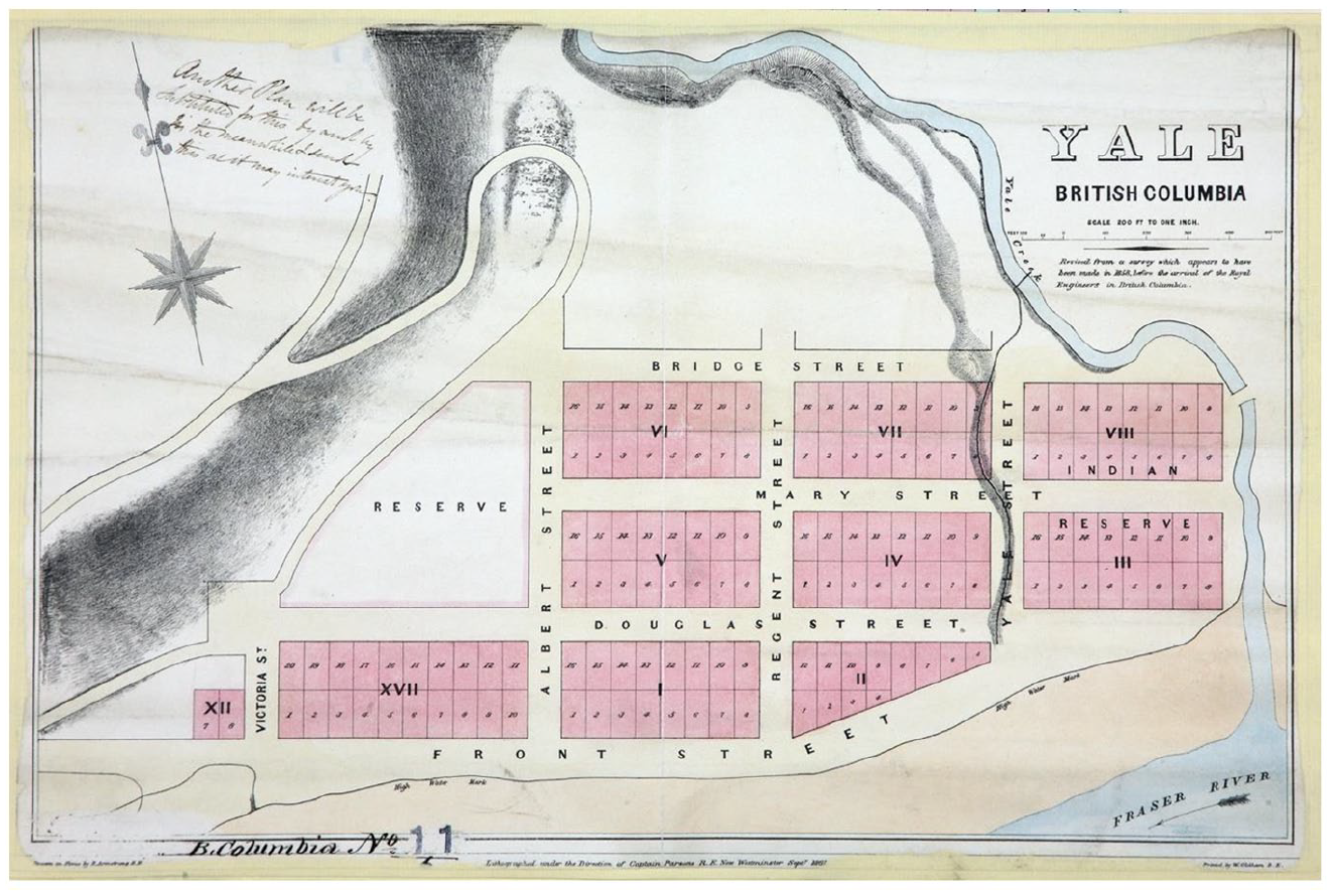
Royal Engineer plan of the Town of Yale, New Westminster (1861) showing numbered lots and First Nations reserve land (Source: BC Genesis archives of Colonial Despatches/National Archives).
Mapping the reserve system was just one element of the broader project of surveying work that the Engineers undertook in British Columbia until they departed in 1863. Through it, Indigenous territories were claimed cartographically – misappropriated – for the settler colony, made subject to land titles and parcelled up for settler farming, mining and colonial infrastructure (Ludgate, 1905; Launders, 1862). The Engineers set out townsites (for example, Launders, 1862; see Figure 2), built or rebuilt roads or sections thereof – including significant parts of the Cariboo Road (Douglas, 1860b), printed British Columbia’s first stamps, designed a colonial coat of arms, planned churches and schools, founded an observatory, set up a Lands and Works Department, a printing office and produced a newspaper. Colonel Moody, the Royal Engineers commanding officer, was the first Chief Commissioner of Lands and Works and also the first Lieutenant Governor of British Columbia (Brealey, 1995: 102; Woodward, 1974: 21). These material and figurative infrastructures underpinned the cultural genocide of the Indigenous population over the rest of the 19th and then 20th centuries, encompassing the reserve system and associated institutions and logics such as those underpinning the church-run residential school system, which delivered Douglas’s ‘proper moral and religious training’ as a mechanism of cultural annihilation.
The example of the Royal Engineers in British Columbia illustrates how colonial military engineering work was a violent process knitting together the material and the epistemic reordering of land and human relationships to it in service of the imperative of settler colonial conquest, bound to colonial capitalism. Territory was a political technology through which the terrain of British Columbia was reordered for the imperatives of European settlement, civilisational ‘development’ and extraction. The building of the Cariboo Road and surveying of land along its route were technical practices of controlling, measuring and ascribing value according to the extractive logics of colonial capitalism. Land was mapped for its potential to yield gold, timber or food. The road underpinned the expansion of White settlement and Indigenous dispossession. It brought settlers physically to sites marked as ripe for European agrarian ‘improvement’, and along its course land was parcelled and sold off to settlers, bringing it within the system of private title and dispossessing Indigenous populations. The reserve system worked in tandem with these processes, being a mechanism to dispossess Indigenous people of their land, and fracture Indigenous land use and epistemic connection, including Indigenous agrarian systems. The reserve system engineered a new relationship between Indigenous populations and land, one in which they were labour for the tasks of colonial extraction. This was a gradual unfurling violence in which Indigenous ties to land were degraded, and European settled territory came to be, one land title and one section of road at a time, a steady reorganisation of land and people towards colonial capitalist imperatives, extraction and resource flows.
Engineering, land and liberal violence in Helmand
One morning in 2010, soldiers from the British Parachute Regiment, supported by soldiers from the Afghan National Army (ANA), advanced on the village of Tor Ghai, ‘a known area of insurgent activity’ in Helmand. Having defeated the ‘insurgents’ in a short firefight, the British and ANA entered the village. The ANA handed out Afghan flags to villagers and the following message was played on loudspeakers: The Afghan National Army and ISAF are here to stay so we can provide security for the development that is coming to your village. You can come out now. This is a new time in your lives, please stay and support your village elders who are working to bring you the many benefits of governance. (Ministry of Defence, 2010a)
Writing for an Ministry of Defence ‘news’ briefing in 2010, the commanding officer of 28 Engineer Regiment described the counter insurgency role of the Royal Engineers in Afghanistan. ‘Our construction efforts’ he wrote, ‘allow for the delivery of security-enabled development’. Military engineering construction work was presented as central to the military strategy of pushing back the insurgents so that the British could then ‘influence and secure the local population and provide an environment within which the green shoots of development can flourish’. The Royal Engineers role was, first, to build and maintain the infrastructure of military occupation– ‘the development and improvement of the ever increasing forward operating bases, patrol bases and checkpoints around the Area of Operations’. This was key to influencing the local population because ‘to give them confidence that we . . . are here to stay, we must live amongst them’. Second, they were to undertake ‘clearance operations’ – something with strong echoes of the demolition practices of earlier colonial-era ‘savage warfare’: ‘I can’t tell exactly how many walls or bridges we have blown up’ the officer wrote, ‘but I do know that over 450 bar mines will never again see the inside of a Quartermaster’s Ammo Store!’ (anti-tank bar mines were here being used as demolition charges). Finally, they were to construct infrastructure for mobility, which was seen to underpin economic development. The jewel in the crown of this infrastructure was Route Trident: a ‘strong and durable route through the area which is already encouraging local markets and social movement around the area’ (National Archives/MOD, 2010a). Across other MOD press releases and briefings, Trident was lauded as an emblem of liberal military success. The road was ‘a real sign of progress which the villagers can see outside their door’ and ‘Route Trident is a perfect example of how we’re extending governance by improving freedom of movement’ (Ministry of Defence, 2010c).
Moving from the Royal Engineers material and epistemic reordering of land and environment within settler colonialism in British Columbia in the 1860s, I next consider the violence of military engineering in Afghanistan as a project of liberal military imposition of development and governance. I detail how the imposition of economic and socio-political norms that is a feature of global coloniality and imperial globality entailed the reordering of human relationships to land in ways that were often very material and at times amounted to forms of dispossession. Examining the Royal Engineers’ activities in Helmand as a violent military mechanism of coloniality, but a coloniality reorganised away (albeit not entirely) from forms of direct conquest towards a prevailing imposition of norms, reveals complexities and nuances in how violence involving land and people’s relationship with it operates in distinct times and contexts within the colonial world system. The imposition of European models of land title were a common feature in both cases, yet in Afghanistan this was not a tool to dispossess Indigenous people of land and transfer it to European settlers, but instead impose European relationships to land, amenable to the market and broader liberal economics, and displace local social relations and values of land (customary, communal) that ‘exceed modern private property and exchange value’ (Halvorsen, 2018). Knotting both cases together are enduring logics and structures of coloniality, including here the supposition of the superiority of European knowledge including European ideas and practices of territory that encompass ways of relating to and living on and with land.
For Route Trident, the Engineers developed and celebrated ‘a whole new approach to road building’ (Bottom, 2010). This was based on the use of a technology called Neoloy, a geotextile made by a private company, PRS (see Figure 3). A Royal Corps of Engineers Major wrote a glowing testimonial for PRS (Bazeley, 2011) and explained to the journal New Civil Engineer how this ‘honeycomb geotextile concertina can be pegged down and backfilled with locally dug soil to form a stable base that is then capped and overlaid with high quality wearing course aggregate’ (Bottom, 2010). In his testimonial, the Major described how Neoloy was chosen by the Royal Engineers ‘after conducting trials in Afghanistan with various infill materials and road make-ups’ (Bazeley, 2011). Neoloy was a compelling technology because it utilised ‘locally dug soil’ to build the road’s foundations rather than expensive aggregate. The use of Neoloy was taken as emblematic of the Royal Engineers’ ingenuity and evidence-based rationality, their ability to innovate, their resourcefulness and adaptability to financial and material parameters. As a technical solution for rolling out Route Trident, and with it controlled, secure terrain and liberal governance, Neoloy was totemic of the Engineers as embodiments of European rationality and industrious liberal ‘improvement’.
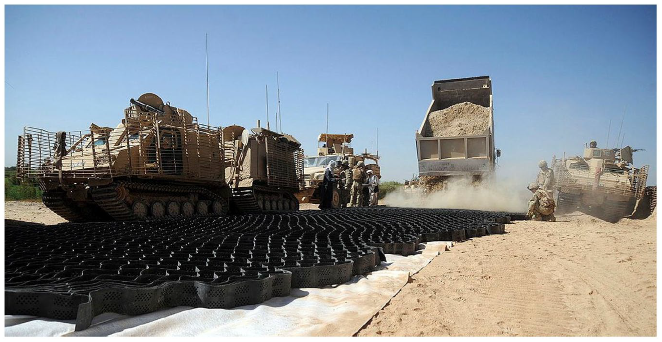
Royal Engineers and Afghan civilian contractors building route Trident using Neoloy (Source: Ministry of Defence, UK MOD Crown Copyright, 2010).
Behind the phrase ‘locally dug soil’ is a process whereby land is appropriated as materiel for the infrastructure of military occupation and capital circulation. The records for the British Area Claims Office for Afghanistan contain a number of claims directly linked to the Royal Engineers appropriation of soil for Route Trident foundation fill. One case reads, ‘Land used for fill for Route Trident’; the British paid out US$1,500. Another record states that the claimant had ‘Soil removed from compound for TRIDENT 1 foundations’ and then details how ‘200 large lorries of soil [was] taken from his 2 jerab compound’. The use of local civilians’ land to extract building material was neither new nor exceptional. Another technology used by the Royal Engineers, the HESCO, is also linked with numerous claims in the records. A HESCO is a collapsible lined mesh container, which can be filled with soil or sand to form a defensive barrier. One claims record reads ‘6 Jeribs of top soil dug up to fill Hesco for PB [Patrol Base] Khuday Noor (PB KDN). Soil planted with wheat’; another, ‘HESCO fill taken from his land’. The Engineers’ appetite for locally sourced fill material seems to have been so rapacious that it was met with a measure of incredulity and queried by the claims office. One record reads: ‘Claims that 100 loads of HESCO fill taken from his 3 Jerabs [sic] of land. Consult STRE [Specialist Team Royal Engineers] as this is getting ridiculous [sic]. How is this being arranged? Have we entered into an agreement at local level? Investigate 27/7/10 Approved 13/8/10’.
This appropriation of ‘locally dug soil’ is based on a particular understanding of land and land ‘use’. British military understandings of Afghan topsoil were that it was a low value, cheap, raw or otherwise waste material. In the case of Route Trident, the fill for Neoloy geotextile literally and figuratively undergirded the plan to impose ‘development’ and pacify the population via liberal capitalist mobility. Rather than the ‘green shoots’ of germinating crops, soil as construction fill is understood to generate ‘green shoots’ of enterprise. One celebratory Ministry of Defence news briefing from 2011 notes that ‘(a)lready, two significant local markets have sprung up along the route’ (Ministry of Defence, 2011). Paying out financial compensation for the appropriation of soil compounds the idea that soil is low value material, which a farmer can physically replace, in contrast to other understandings of value such as those recognising that soil itself and its capacity to sustain life is something that can take generations to achieve. There is currently no available data on what this sort of long-lasting degradation of land would mean for the farming communities affected in this way.
As well as becoming a military extraction zone for construction material, land was also routinely appropriated as a site for building itself and it was degraded through the destruction of crops and civilian agrarian infrastructure. Once again, the Claims Office records provide some partial snapshots of the sort of land appropriation and degradation that accompanied military engineering development work: ‘7 x jaribs of corn destroyed when Route Trident was built’, ‘Agricultural [land] destroyed by the Route Trident Build’, ‘Agricultural Land destroyed by the route trident build 6 jerab of land’, ‘Compound destroyed to make way for TRIDENT 2 build’, ‘Destruction of Wall and Trees to make way for Route Trident’. There are numerous claims such as these in the records. It is instructive that British military accounts of the building of Trident often observe that the planned route for the road originally bypassed villages and went across open farmland. Keen to protect their farmland, local people pressed for it to go through their villages (Ministry of Defence, 2010c). This is presented within the Ministry of Defence briefings (written to generate positive news stories about British counterinsurgency) as illustrating that the road was built ‘for’ local people and responsive to their needs. An alternative reading is one of colliding epistemic relationships to land, and of colliding conceptions of land and security. Farmland was seen from a military engineering perspective as ‘empty’ land that represented a path of least resistance for a road building team, and avoided, in the context of the counter insurgency, the military-strategic insecurities of settlements. To Afghan civilians reliant on the land for food and income, their fields were crucial to their survival and their resource security as well as being, potentially, communally held and valued community assets, meaningful in ways that exceed capital relations.
The way in which the Claims Office for Afghanistan institutionalised financial compensation for various forms of routine military land damage, degradation and appropriation had the effect of binding together land damage with a reordering of the legal relationships that people had to and with land, imposing global liberal and eurocentred norms of property title that are amenable to liberal economy and governance. Compensation claims for damage to land were dependent on the claimant providing documentation proving they owned the land. Throughout the records of the Claims Office are references to ‘LODs’. This was an acronym for Land Ownership Documents, and typically appears in the records as something that was provided or remained outstanding and therefore a barrier to progressing a case. For example, one record from 2010 reads ‘needs ID and LOD 06/04/10 Provided ID and photos and sales agreement. Needs to register land before any assistance can be offered’. The use and ownership of land in Afghanistan has historically been informal, customary and sometimes communal. Decades of war mean that even where official title documents existed, they have often been destroyed, and the population has experienced successive periods of displacement and mortality. It is estimated that as of 2013, only 20% of land was what would be understood as ‘accurately titled’ (Gaston and Dang, 2015). The establishment of legal registration and title of land in Afghanistan was seen as central to economic development and was the focus of several projects including, in 2007, a joint initiative between the Asian Development Bank and the UK Department for International Development (DFID; Gaston and Dang, 2015). The process of claiming for damage to land pressured claimants to seek formal property titles. In this way, the physical reordering of land during military engineering projects was accompanied by the reordering of people’s relationships with land to bring them within a liberal legal regime of private property ownership.
Route Trident, other roads built by the British, and other military infrastructures such as patrol bases, were accompanied by the clearance of land and the exercise of control over what farmers could grow. The Claims Office recorded numerous examples of claims for the felling of often significant numbers of trees: ‘36 non-fruit bearing trees cut down to improve the STAP [Surveillance and Target Acquisition Plan] of CP OBIDULLAH’, ‘up to 300 trees and 100 grapevines have been cut down by ISAF at CP [command post] SHAPARAK, 52 trees (12 Pomegranate, [sic] 20 non-fruit and 20 young non-fruit) cut down at CP [command post] TORA to increase STAP’, ‘72 trees cut down by ISAF to improve security’. As with the appropriation of topsoil, the routine destruction of orchards and vineyards will have had a deleterious effect on rural economies for a significant period of time as trees take years to mature and would not have been replanted during military occupation of the site. There are also numerous claims in the records that relate to the prohibition of tall crops, for instance: ‘Notified that high crops cannot be grown within 300 m of Route Trident’, ‘Prevented from growing corn for security reasons. He will grow low crops. Not allowed to grow tall crops’, ‘30 Jerabs of corn not to be grown for Route Trident security’. The prohibition on agricultural use of land or on the growing of specific crops evidently had a significant impact on farmers. One claim record details how the applicant was ‘prevented from farming land’ and ‘was paid compensation last year’ but ‘this was a once only payment to allow claimant time to make other arrangements’ and the claim was then denied. Another record describes how a farmer ‘Feared being shot by BRITFOR if he tended his fields 50Mr × 50Mr over last three years which are next to FOB [Forward Operating Base] Robinson; has now been told by FOB that it is fine for him to farm field again’. The exclusion from land in ways such as this can be understood as a form of dispossession, one that has the potential to fundamentally reorder people’s relationships to land and position them for particular forms of capitalist labour exploitation as they are compelled to ‘make other arrangements’.
The Royal Engineers were proud employers of local labour on infrastructure projects throughout Helmand and it was seen as a central part of counterinsurgency strategy, bound with notions of economic development. The employment by British Engineers of ‘local labour’ has a long history, as described, and has been central to attempts to pacify populations and bring them within capital relations. In its recent wars of liberal counterinsurgency, the direct employment by the Royal Engineers of local men on ‘reconstruction’ projects has been seen as a means of ensuring they did not join the insurgency (Bickers, 2005: 122–123). One Ministry of Defence ‘news’ briefing described how local ‘civilians have assisted the “sappers” with some of the physical work. Organised as a “cash for works” scheme, effort was made to employ workers from the nearest village to each section of the route in order to engender a sense of local ownership of the project’ (Ministry of Defence, 2011)
and bring ‘welcome cash into the area’s economy’ (Ministry of Defence, 2010c). In another example, 20 people ‘were given jobs preparing and loading crushed stone for repairs to a road in the area of PB TALIBJAN near Musa Qa’lah DC’ (Ministry of Defence, 2010d). Low-skilled and short-term jobs providing labour for Royal Engineers construction projects was therefore framed as an aspirational way for local people to enjoy the benefits of liberal economic development and be secured and pacified by capital relations.
Route Trident illustrates how military violence within global coloniality and imperial globality encompasses the fracturing and reordering of human relationships with land and the imposition of eurocentred knowledges of land and land use. Road building is a technique for controlling terrain and constituting ‘secure’ liberal territory within counterinsurgency, amenable to flows of capital and market. The material destruction of land and environment – its incorporation into roads and fortifications for instance – went hand in hand with more epistemic rearrangements that coerced the population into liberal private property regimes, fracturing long-standing communal relationships with land and rural economies. This and other modes of control over land and terrain such as excluding people from working their land for reasons of British military security, reorganised local configurations of labour, positioning people who might previously have worked their land for menial and racially ordered wage labour.
Conclusion
The creation of the Cariboo Road in the settler colonial context of British Columbia, and Route Trident in that of ‘postcolonial’ liberal warfare in Helmand, illustrate the military violence of land use and infrastructure projects. Military surveying and mapping of land, the destruction of trees, the issuing of land title and erosion of customary and communal relationships with land, the use of soil as military materiel and the prohibition of particular forms of land cultivation: all are examples of the violence of materially and epistemically reordering land and human relationships with it. Such violence has been fundamental to the constitution of the colonial world system and also a central feature within its maintenance. Military infrastructural activities are not benign military processes, adjuncts to or ameliorative of ‘real’ violence and neither are they only contingent upon or enabling of violence happening elsewhere. Military infrastructure is central to the waging of military power, and at the same time it is military violence, violence that cannot be disconnected from other violences including those that target individual human bodies.
Across this article, I have charted how the violent appropriation, degradation and reshaping of land has occurred across different periods, locations and arrangements of the colonial world system, not being limited to colonial conquest but also operating as a key aspect of the imposition of norms within postcolonial liberal war. In British Columbia in the 1860s, the Royal Engineers built both the literal and figurative infrastructures of and for settler colonialism and colonial capitalism, fundamentally and forcibly reordering Indigenous relationships to land through the interconnected projects of White settlement, agricultural development and resource extraction. European political technologies of territory such as the conjoined techniques of surveying, mapping and land title were the Engineers’ primary activities and fundamental to settler colonial appropriation, dispossession and degradation of land. In the case of the infrastructures of liberal war in Helmand, Afghanistan, after 2001, land was violently reordered to support the global economy, in ways that marginalised Afghan approaches to territory, both material and epistemic, encompassing rural economies and their immanent relationships to and with land. In the service of the colonial/liberal imperatives of flow and circulation for capitalist relations, Royal Engineers infrastructure projects such as Route Trident entailed extensive damage, degradation and reordering of land. In its most stark material terms, farmland was utilised as literal base materiel for the road as a mode of liberal capitalist and extractive reordering. Land was also rendered within liberal terms of capital ownership that instated the legal infrastructures for liberal economy, manifesting – for instance – in the refusal to pay compensation claims unless ‘proper’ LODs were produced. This eroded customary and communal approaches to and systems of land use and ownership. Across both cases, this violence was often incremental: one small section of road constructed, a grove of trees felled, a tract of land surveyed, another land title issued, unfurling and amounting to a cumulative process of the attritional fracturing of existing relationships with land and environment.
This discussion of the violence of military infrastructure and land use may, it is hoped, support and open ways of addressing a range of cognate concerns. First, although this article has been concerned with distinctly military examples, its account of the violence of land degradation, appropriation and reordering could be brought to bear not just on military projects but on various state, non-state and corporate activities. Second, while I have been concerned with the engineering processes that initially create infrastructure projects, there is important work to be done in addressing the violent afterlives of military infrastructure that has been turned over (as both the Cariboo and Trident roads now are), to civil use. Third, the approach could illuminate the violence of military activities beyond contexts of conquest and warfare; the militaries of contemporary liberal states are engaged and invested in various forms of liberal ‘capacity building’ that develop literal and more figurative infrastructures to bring states and populations within global liberal capital relations. Fourth, building out from the observation that violence involving land is inextricably connected with that against other ‘bodies’, including human bodies, the approach taken here could provide a starting point for tracing the violent contingencies and circulations that link violence across multiple places and bodies, material and epistemic.
Footnotes
Acknowledgements
Jamie Johnson, Lisa Stampnitzky and members of the IR Group in the Department of Politics and International Relations, University of Sheffield offered insightful and encouraging comments on a draft of this article. The submission was also greatly improved by the generous, supportive and incisive input of the article’s reviewers.
Funding
The author(s) received no financial support for the research, authorship, and/or publication of this article.